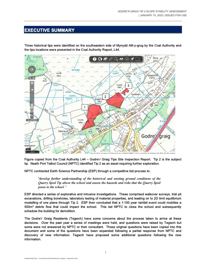
Three historical tips were identified on the southeastern side of Mynydd Allt-y-grug by the Coal Authority and the tips locations were presented in the Coal Authority Report, L44.
Figure copied from the Coal Authority L44 – Godre’r Graig Tips Site Inspection Report. Tip 2 is the subject tip. Neath Port Talbot Council (NPTC) identified Tip 2 as an asset requiring further exploration.
NPTCBC contracted Earth Science Partnership (ESP) through a competitive bid process to:
“develop further understanding of the historical and existing ground conditions of the Quarry Spoil Tip above the school and assess the hazards and risks that the Quarry Spoil poses to the school.”
ESP directed a series of explorative and intrusive investigations. These comprised walkover surveys, trial pit excavations, drilling boreholes, laboratory testing of material properties, and leading on to 2D limit equilibrium modelling of one plane through Tip 2. ESP then concluded that a 1:100 year rainfall event could mobilise a 500m3 debris flow that could impact the school. This led NPTC to close the school and subsequently schedule the building for demolition.
The Godre’r Graig Residents (Tegwch) have some concerns about the process taken to arrive at these decisions. Over the past year a series of meetings were held, and questions were raised by Tegwch but some were not answered by NPTC or their consultant. These original questions have been copied into this document and some of the questions have been expanded following a partial response from NPTC and discovery of new information. Tegwch have proposed some additional questions following the new information.
GodrerGraig Tip 2 – Comments and Questions by Tegwch – Issued for Use
GODRE’R GRAIG TIP 2 SLOPE STABILITY ASSESSMENT | JANUARY 10, 2023 |
One concern is that the properties used in the modelling are overly conservative and there has been an unsubstantiated ‘leap of faith’ that a given (unspecified) rainfall event can mobilise enough material to impact the school building. The remedial options presented comprised of demolition of the former school, installation of a barrier, or removal of the tipped material.
Geotechnical investigations produced geotechnical logs. Visual observations of the material arising from these pits noted particle size up to 700mm. Geotechnical testing was performed on particles less than 20mm in size and then conservatism was applied to these test results. The 20mm particle size appears to be a function of the limitations of ESP’s testing laboratory. NPTC state that larger particle sizes can increase the phi angle (angle at which the material will move)
“If there are many of them, they could interlock and indeed lead to an increase in phi.”. Review of the trial pit logs show that the Coarse Discard particles:
“generally comprises interlocking, angular and tabular boulders and cobbles of weak to medium strong sandstone”
(quoted from the summary of Coarse Discard description). NPTC’s consultant has provided a vague reference to one, two, or three British Standards / CIRIA guides was given for the selection of the conservatism towards these values, but nothing verifiable.
The conservative material parameters were used in the modelling of the slope in the naturally occurring Glacial Diamicton and the weathered bedrock layers. The “realistic case” parameters gave unrealistic Factors of Safety (Factors of Safety below 1) and was noted as such, but still were published in the report. A Factor of Safety below one means that the slope would have failed. An upper case set of parameters were used in the model and these gave a Factor of Safety. However, NPTC note that “a minimum factor of safety of around 0.95 can be assumed when considering the current slope geometries” which is still open to criticism as a Factor of Safety of 0.95 means the slope would have already failed (which is not the case). Additional modelling assessments were performed using an increasingly higher water table. The higher water table was used presumably to mimic the trigger event of a 1:100 rainfall event’s water within the slope. Unsurprisingly the increase in water table decreased the Factor of Safety even lower than 0.95 Factor of Safety.
The modelling performed to date is limit equilibrium modelling. This is purely a ratio of the sum of restorative forces (friction and cohesion) over the sum of disturbing forces (gravity and water). It gives an instant in time of what the ratio is. Once the slope moves there are a new set of forces disturbing a new slope geometry and the model should be rerun. This modelling the slope after movement is observed in the model is effectively Finite Element modelling. This can add a temporal aspect to the model to see how the slope will deform over time and different material properties. If the slope was found to continue to deform over time rapid mass movement modelling could be performed to see if the risk level at the building or other soundings is acceptable given the trigger event. No alternative analysis of a debris movement path has been estimated other than the one section undertaken in the Limit Equilibrium modelling as this is the section between the quarry, Tip 2, and the former school building.
One confounding factor is neither NPTC nor ESP have proposed an acceptable Factor of Safety for the tip or the slope as a whole. This is similar to being given a speeding fine on a road without a published speed limit. It is curious that NPTC do not cite “Guidelines for Mine Waste Dump and Stockpile Design, 2017” in any of their reports. However, there are numerous references to “modern engineering standards” but do not state what these standards are or what Factors of Safety may be acceptable.
According to NPTC’s consultant groundwater fluctuations are the key factor in the stability of the tip. However, there does not appear to have been any quantitative correlation between weather events and groundwater observations in the tip or on the hillside. No magnitude of rainfall other than a vague 1:100 year rainfall event has been proposed as a trigger for a mass movement event. No comment was provided at whether this magnitude of rainfall was likely observed over the life of the tip. (Note NPTC report published in
GodrerGraig Tip 2 – Comments and Questions by Tegwch – Issued for Use
s5sq4q
nhf6y1
j1fnjv
dyf71t
64tpza
ba9w4c
jjc0fn
bb55jd
68z0ky
e1dioc