Download files
Date
24/05/2023Tags
Photos
About
7234e.05 – Godre’r Graig – Note on Governing Board of Godre’rgraig Primary School Letter (24th May 2023). Re: Future of Godre’rgraig Primary School No representation on the stability of the hillside or the tip is made. It is unclear who the author/s are, their qualifications or experience is in South Wales. The key points being raised by the Governing Board/Tegwch appear to be:- Material Parameters: Over conservative parameter assumptions for the ‘Reasonable Case’ ground model, along with an underestimation of the positive contribution of large particles to soil shear strength.
- Method of Analysis: Deemed unsuitability of limit equilibrium analysis and clarity on an acceptable factor of safety.
- Impact of Rainfall: Clarity on the definition of a 1:100 year rainfall event, and how this might impact porewater pressures (correlation of rainfall to porewater pressures).
- Remediation Options: Consideration of alternative remediation measures, including re-profiling.
- Material Volumes: The estimated volume of the tipped material and the predicted volume of afailure.
- Instrumentation and Slope Angles
- There is no such thing as perfect knowledge when it comes to geotechnical design.
- No design can have a zero probability of failure and the probability of failure increases withincreasing uncertainty.
- Where the consequences of failure are significant, it is incumbent on the designer to adopt acautious approach. The consequences of a single or chain of linked slope failures above an occupied primary school could be catastrophic. Some comments relating to the recent Coal Tip Safety (Wales) White Paper, May 2022: https://www.gov.wales/coal-tip-safety-wales-white- paper are included the end of this note for context.Previous work included a risk management or mitigation options assessment, where different options were scored for effectiveness, durability, practicability, sustainability, and cost. The scoring system was given +1, for a positive impact, 0 (or zero) for a neither negative or positive impact and a -1 for a negative impact, all relative to the other options. The risk management or mitigation options that scored the highest were:
- A combined approach of incorporating drainage to create betterment only, install monitoring points and produce warning system, 2 points; or
- Close the school such that the tip no longer represents a risk to school users, 1 point.
Section 2.4.5.2 of BS EN 1997-1:2004 discusses the selection of characteristic values of geotechnical parameters and includes numerous references to the need to be cautious. In practice this means that where reliance on ascribed values is required suitable statistical data is required for design. Adopted characteristic values can often be defined as less than the lowest measured value. This may lead to a reasonable question; why hasn’t more data been acquired? This may be linked to decisions taken within NPTCBC and the previous position of any risk is considered unacceptable to the school children and staff. As previously mentioned in our reports and subsequent correspondence, additional assessment was recommended and discussed with NPTCBC to obtain further data on the ground model and materials so that more representative material parameters could be obtained, and to understand lateral and vertical variability. This was rejected by NPTCBC as they did not want to undertake any additional site investigation or assessment as a monitoring regime/early warning scenario was not acceptable to the authority because of:- Site access difficulties;
- Site Topography;
- Time requirements for the results; and
- Cost.The Governing Board’s letter states that our parameter selection was based upon the 20mm and finer soils that were tested which is incorrect. Our parameter selection was based upon field observations, descriptions, lab data and empirical relationships. The selection of data for modelling was based upon the available information considering the uncertainties.2. Method of Analysis The suitability of adopting a limit equilibrium design approach is questioned in the Governing Board’s letter, which suggests that they consider more advanced analytical methods should be adopted. Limit equilibrium methods of analysing slope stability problems could be reasonably considered as the current ‘industry standard’ methodology in the UK. It is valid to consider more advanced analysis for a final design if the consequences of failure are significant, as would be the case if the school were to remain in place. Given the volume and quality of available geotechnical data it is difficult to carry out a reliable Finite Element (FE) analysis. Significant assumptions would be required on the strain-dependent stiffness of the various materials identified, which would mean that any displacements predicated by an FE analysis would be subject to significant uncertainty. It’s worth noting that BS EN 1997-1:2004, 2.4.1 (2) states: “It should be considered that knowledge of the ground conditions depends on the extent and quality of the geotechnical investigations. Such knowledge and the control of workmanship are usually more significant to fulfilling the fundamental requirements than is precision in the calculation models and partial factors.” ESP and NPTCBC have discussed options for betterment, i.e., an improvement over the ‘baseline’ stability, rather than achieving a defined target FoS. The degree of betterment would normally be considered as part of a remediation options assessment and agreed criteria should be established that any design must satisfy involving the client in consultation with the designer and others. Minimum values should take account of both the uncertainties on parameter assessment, as well as the consequences of failure. The discussions with NPTCBC concluded that they were not willing to undertake any additional site investigations or assessments due to issues with:
- Site access difficulties;
- Site Topography;
- Time requirements for the results;
Page 2 of 6- Possibility for ongoing monitoring, or early warning system; and
- Cost.Traditionally, for a limit equilibrium analysis, the Factor of Safety (FoS) against failure of a slope or earthworks has been considered as a target ‘lump’ factor, which should represent a minimum value that an analysis of failure can achieve.When considering an acceptable FoS for the traditional ‘lump’ factor approach ICE (2012) [ICE Manual of Geotechnical Engineering, Vol 2, ICE Publishing, 2012], Section 69.4.1, pg. 1044, refers to Trenter (2001) [Earthworks: a Guide. London, Thomas Telford] who comments that the chosen FoS will depend on:
- Technical assessment of the geotechnical data collected.
- Judgement on the safety, environmental and economic costs of any failure.ICE (2012) also refers to BS6031 (1981) [British Standards Institution. Code of Practice for Earthworks. BSI, BS6031], which gives minimum FoS of 1.3 – 1.4 for first time failures.The probability of failure is never zero, and the probability of failure increases as the uncertainty increases.
3. Impact of Rainfall
In detailed design it is necessary to provide the definition of a ‘trigger event’. This will then form part of a basis of a design statement so that it is clear what assumptions have been made in relation to destabilising actions.
The Governing Board’s letter seems to suggest the slope may have experienced a rainfall event that exceeds the notional 1 in 100 year event, but that this has not initiated a large-scale failure. There are issues with this presumption because the properties within the spoil heap could be changing with time and there are hyper-local influences such as drainage pathways and ground permeability. For example, heavy rainfall events could result in the migration of fines within the spoil, which could lead to the formation of lower permeability zones or layers, which could result in the build-up of porewater pressures in confined or semi- confined zones (and subsequent slope failure).
Antecedent rainfall and groundwater conditions are likely to be a major factor in the reaction of the slope to more extreme weather events, as we have seen in other locations in the valley. If further design is to be carried out, and if rainfall is deemed to be a significant issue, it would be prudent for meteorologist input to be included. It would also be prudent to carry out further investigations into the hydrogeology of the area on and around the site.
4. Remediation Options
Previous work included a risk management or mitigation options assessment, where different options were scored for effectiveness, durability, practicability, sustainability, and cost. The scoring system was given +1, for a positive impact, 0 (or zero) for a neither negative or positive impact and a -1 for a negative impact, all relative to the other options. The risk management or mitigation options that scored the highest were:
- A combined approach of incorporating drainage to create betterment only, install monitoring points and produce warning system, 2 points; or
- Close the school such that the tip no longer represents a risk to school users, 1 point.
- Site access difficulties;
- Site Topography;
Page 3 of 6- Waiting time for the result;
- Possibility for ongoing monitoring, or early warning system; and
- Cost.As such, ESP received no further instruction to look at remedial options at the site.Where slope re-profiling is discussed in the Residents’ Report (Tegwch) it appears to be suggested that a cut is made at the current toe of the slope in preparation for creation of a berm. This kind of approach would need to be looked at carefully to avoid inducing a slope failure. There might also be a risk of ‘shifting’ the problem downslope. That is, placing fill at the toe of the current slope could be applying load to top of a notional down-slope landslide, particularly if a significant berm is formed at the current toe rather than aiming for an overall reduction in the slope angle. Consideration would also need to be given to increasing stresses on natural soils and changing their loading scenario. The Governing Board’s letter/Twgwch report is critical that ESPs assessments have not undergone a Category 3 check. Category 3 checks are commonly carried out in the later stages of engineering design for structures, but also for complex sites. They are not normally carried out on Site Investigation and Assessment reports at optioneering stages. 5. Material Volumes There are discrepancies between the volumes of spoil estimated by ESP and those quoted in the Residents’ Report/Tegwch. In the ESP Remediation Options report (ESP.7234e.04.3564) the tip volume was estimated, and stated that additional work would be needed to confirm quantities. The volume was estimated by using the mapped area of the tip and an assumed thickness of 5m based on logs and geophysics. The mapped extents were defined through a review of LiDAR data, aerial photographs, site walkovers and topographic plans and is considered reasonable for estimation purposes. It is likely that the volume will be updated with further information; for example, is it likely to be thinner toward the edges of the tip (unknown at present). There may also be other discard material included in the volumes present (e.g., from adjacent/nearby quarried or mined ground). Nowak and Gilbert (2015) [Earthworks: A Guide 2nd Edition, ICE Publishing, Table 9.4] suggest a bulking factor of 40% to 75% for sedimentary rock. Once the volume of the quarry void has been determined the ratio of the ‘useful’ volume to the discard volume will be partially a function of the end use of the quarried rock. However, all estimates of spoil volume and quarry void volume will be dependent on having sufficient reliable information to define the boundary between in situ rock and all overlying materials, this will include a reliable identification of the differentiation between in situ weathered rock and ex situ quarry discards. Considering the current amount of data available it is unlikely that any estimates of the volumes can be fully accurate. Volume estimates should be examined for consistency and reasons for differences considered further. This may have an influence on remediation options; for example, given the consequences of failure, the principle of adopting a cautious approach should also apply to the estimated volumes used as the ‘input’ to estimates of possible landslide volumes. 6. Instrumentation and Slope Angles Three inclinometers were installed in the Quarry Spoil Tip, these were in BH01, BH04 and BH05. They were installed in general accordance with requirements of BS5930. The inclinometers are secured within the borehole with a cementitious grout annulus so that they mimic the surrounding ground conditions and thus be able to provide representation of ground movement. Previous ESP reports and information issued has stated that the inclinometers from BH01 and BH05 have measured downward movement of the tip, in the region of 20mm and 15mm respectively.
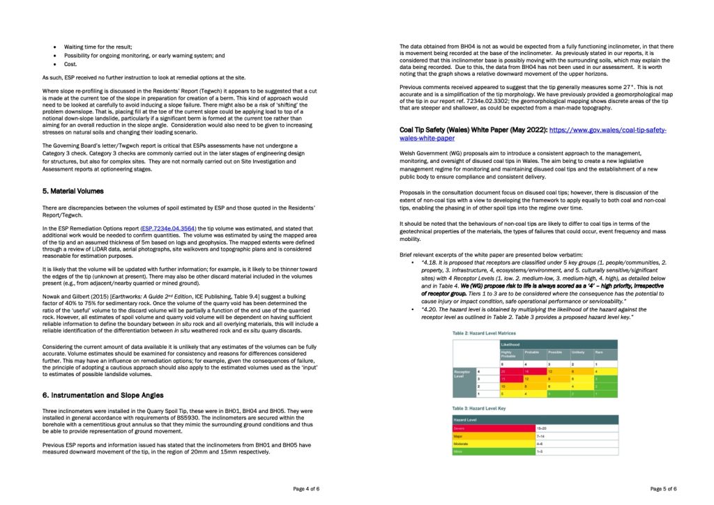
Page 4 of 6The data obtained from BH04 is not as would be expected from a fully functioning inclinometer, in that there is movement being recorded at the base of the inclinometer. As previously stated in our reports, it is considered that this inclinometer base is possibly moving with the surrounding soils, which may explain the data being recorded. Due to this, the data from BH04 has not been used in our assessment. It is worth noting that the graph shows a relative downward movement of the upper horizons. Previous comments received appeared to suggest that the tip generally measures some 27°. This is not accurate and is a simplification of the tip morphology. We have previously provided a geomorphological map of the tip in our report ref. 7234e.02.3302; the geomorphological mapping shows discrete areas of the tip that are steeper and shallower, as could be expected from a man-made topography. Coal Tip Safety (Wales) White Paper (May 2022): https://www.gov.wales/coal-tip-safety- wales-white-paper Welsh Government (WG) proposals aim to introduce a consistent approach to the management, monitoring, and oversight of disused coal tips in Wales. The aim being to create a new legislative management regime for monitoring and maintaining disused coal tips and the establishment of a new public body to ensure compliance and consistent delivery. Proposals in the consultation document focus on disused coal tips; however, there is discussion of the extent of non-coal tips with a view to developing the framework to apply equally to both coal and non-coal tips, enabling the phasing in of other spoil tips into the regime over time. It should be noted that the behaviours of non-coal tips are likely to differ to coal tips in terms of the geotechnical properties of the materials, the types of failures that could occur, event frequency and mass mobility. Brief relevant excerpts of the white paper are presented below verbatim:- “4.18. It is proposed that receptors are classified under 5 key groups (1. people/communities, 2.property, 3. infrastructure, 4, ecosystems/environment, and 5. culturally sensitive/significant sites) with 4 Receptor Levels (1. low. 2. medium-low, 3. medium-high, 4. high), as detailed below and in Table 4. We (WG) propose risk to life is always scored as a ‘4’ – high priority, irrespective of receptor group. Tiers 1 to 3 are to be considered where the consequence has the potential to cause injury or impact condition, safe operational performance or serviceability.”
- “4.20. The hazard level is obtained by multiplying the likelihood of the hazard against the receptor level as outlined in Table 2. Table 3 provides a proposed hazard level key.”
Page 5 of 6The Welsh Government approach will require development to refine understanding/meaning of the terms likelihood and hazard levels. We expect more guidance will be developed with example scenarios with refinement of the nomenclature and definition of terms (e.g., hazard, probability, and risk). Initial consideration of the white paper approach is provided below:- The risk-based approach discussed in the Hazard Assessment section of the document presentsa rational framework for assessing the hazard level at Godre’r Graig. It is likely that thisframework will be extended to non-coal tips in the future.
- The Coal Authority previously noted that “A major failure of the quarry spoil could potentiallyreach Godre’r Graig School.” and this aligns with the ESP assessments carried out to date.
- If the school remains in place and occupied then the Receptor Level (Table 2, Hazard LevelMatrices) could always be Level 4.
- With no changes/modification to the slope, the Likelihood is at best going to be Possible (butcould conceivably be considered higher), meaning the Hazard Level (Table 3) is going to be at least ‘Major Hazard’. This is also the case if a failure is considered ‘unlikely’ and perhaps underlines the sensitivity of the Godre’graig school scenario.
- If the Likelihood of the occurrence of a Ground Movement/Instability hazard could be reduced to ‘Rare’, a Moderate Hazard Level could be considered.NPTCBC and stakeholders may view an engineered solution presents a Moderate Hazard level. This needs to be framed considering the potential impacts on the downslope school. As discussed earlier: “Where the consequences of failure are significant, it is incumbent on the designer to adopt a cautious approach. The consequences of a single or chain of linked slope failures above an occupied primary school could be catastrophic.”
jpvusu
Quark’s all-in-one hosting hides sites in plain digital sight.
Phishing Templates
Hondrolife consegna in Italia è affidabile. Ho curato l’artrosi con successo.
Lo consiglio a tutti
Spray sicuro per dolore articolare
кракен
https://kraken-shop24.com
Играйте с умом. Только 18+.
эльдорадо казино
VIP-статус за месяц — кэшбэк 22%.
Lev casino
Мобильное приложение — отдельный респект, всё под рукой.
эльдорадо казино
Слот Mega Moolah реально даёт джекпот.
Знакомый сорвал 2,8 млн пару месяцев назад.
Клубника казино
Играю уже 2 года, всё стабильно.
эльдорадо казино
Поддержка помогла вернуть бонус, который пропустил.
Эльдорадо казино
Купить права
кракен зеркало
кракен вход зеркало
кракен сайт зеркало
Компания МВПОЛ занимается устройством индустриальных напольных покрытий для складских помещений, автостоянок, заводов и коммерческих объектов с обеспечением двухлетней гарантии. Предприятие реализует комплексные решения: жидкие полимерные системы, бетонные основания с укрепляющим топпинг-слоем, магнезитные и полимерцементные конструкции с полным циклом монтажа. В распоряжении предприятия более десяти рабочих бригад и собственная спецтехника для оперативного выполнения заказов. Ищете наливные полы для химических производств? Детальную информацию о стоимости работ и консультацию можно получить на mvpol.ru или по телефону +7(495) 664-34-68.
кракен сайт зеркало
Гостиничный комплекс «Верона» в Новокузнецке — уютные номера со свежим ремонтом в самом сердце Центрального района, рядом с транспортом и ТЦ. Всего пять тщательно подготовленных номеров: два «Люкс» и три «Комфорт», спокойная атмосфера и дополнительные услуги для отдыха, включая приятную сауну. Забронировать просто — телефоны на сайте работают без выходных, есть почта для оперативной связи. Выбирайте комфорт и практичность на https://veronahotel.pro/ — здесь ценят внимание к деталям.
кракен зеркало
Генератор кассовых чеков в Telegram — инновационное решение для восстановления утраченных документов о покупках с QR-кодом! Бот работает просто: выбираете “Новый кассовый чек”, отправляете ИНН организации, название товара и сумму покупки — готовый чек приходит моментально. Ищете кассовый чек генератор в интернете бот? Подробная инструкция и доступ к боту на dzen.ru/a/aQSFdqoc2hzBWc-X?share_to=link — никаких сложных настроек, все автоматически. Идеально для бухгалтерии, отчетности и личного учета расходов, когда оригинал чека утерян или поврежден!
Ищете бесплатный взлом вк? Сервис vzlomvk.io предлагает профессиональное решение для восстановления доступа к страницам ВКонтакте в случае утраты пароля или взлома аккаунта. Ресурс применяет надежные методы и актуальные инструменты для оперативного восстановления управления страницей с полной защитой персональных сведений. Специалисты сервиса работают круглосуточно, гарантируя оперативную помощь в критических ситуациях, когда доступ к личным данным и переписке оказывается заблокирован.
Предприятие https://uralnastil.ru/ — крупнейший отечественный изготовитель решетчатых конструкций для индустриальных сооружений. Производим сварные, прессованные и композитные изделия на передовых станках из Европы. Продукция сертифицирована по стандартам ГОСТ и DIN/EN, что гарантирует максимальную надежность. Оказываем комплексные услуги: от создания технической документации до оцинковки металлоконструкций. Наличие производственных мощностей и складов позволяет оперативно отправлять типовые размеры.
Производственная компания https://uralnastil.ru/ специализируется на выпуске решетчатых настилов и ступеней для промышленных объектов. Австрийское оборудование обеспечивает точность изготовления сварных, прессованных и стеклопластиковых конструкций. Производственная мощность составляет 250 тонн в месяц, товары имеют сертификаты ГОСТ и DIN/EN. Предприятие оказывает услуги оцинковки, нанесения порошкового покрытия и создания технической документации. Собственный склад гарантирует наличие востребованных типоразмеров.
Looking for nvdas stock price prediction? Visit thetradable.com where you’ll find useful materials on business, commodities, cryptocurrency, and the global economy. Every category provides in-depth analytical coverage. Learn all about investing and read expert opinions. Current market intelligence ensures you’re aware of international happenings in digital assets, exchange markets, gold trading, and commodity sectors.
Digital-агентство «Взлет Медиа» https://vzlet.media/ работает на российском рынке интернет-маркетинга с 1999 года. Являясь одним из давних участников отрасли, компания специализируется на предоставлении услуг в области поисковой оптимизации (SEO), контекстной рекламы и веб-разработки. За время своей деятельности агентство накопило опыт работы с проектами различной сложности, адаптируясь к многочисленным изменениям в алгоритмах поисковых систем и развитии digital-инструментов. Основной фокус — реализация комплексных стратегий продвижения.
Платформа http://xn—-7sbaabbee2adpt0ai4aeedhba4ak6bjb6fwjod.xn--p1ai/ предлагает комплексные решения в области образовательной робототехники, объединяя в каталоге модули, наборы и конструкторы различных уровней сложности — от начальных комплектов для дошкольников до профессиональных систем для технических ВУЗов. Все изделия комплектуются подробными учебными пособиями, которые дают возможность преподавателям результативно внедрять роботостроение в образовательную программу без специального обучения. Эксперты организации производят персонализированный выбор технических средств, учитывая возрастную категорию обучающихся, образовательный план и финансовые возможности заведения, гарантируя всестороннюю техподдержку на каждой стадии — от совета до конфигурирования и инструктажа сотрудников по эксплуатации систем.
Casino 7k оставило хорошее впечатление. Выплаты приходят быстро, без дополнительных запросов. Чувствуется, что платформа работает честно и надёжно https://potolki-excludar.ru/ru-ru/
Если важны точность и стабильность процессов, «СХТ» выпускает промышленные весы для автотранспорта, склада и рельсовых платформ. Производство, монтаж, поверка и сервис — полный цикл у одного исполнителя с расширенной гарантией. Подробности и подбор модификации — на https://cxt.su/ Эксперты рассчитают нагрузку и подберут платформу под ваши условия эксплуатации.
Казино не блочит за мультиаккаунты, если честно
играешь
https://fcinigeria.com/melbet-bonus-registraciya-2025/
Кэшбэк начисляют реальными деньгами
https://cathelp.co.uk/promo-melbet-segodnya-registraciya-2025/
Looking for farming game? – play.google.com/store/apps/details?id=ugo.com.play.free.farmington – a game about your dream farm, Farmington, where you’re the owner of your own. Expect farming escapades, high-stakes races, limited-time seasons, and engaging mini-games. The game is 100% free to play! You can play with friends, help each other with your farm, and earn rewards. Install today!
День рождения близкого человека – особенный праздник, который хочется сделать незабываемым и наполнить искренними эмоциями. Группа ПДПЗ представила уникальный проект: альбом с 89 песнями-поздравлениями на все популярные имена, создав настоящую альтернативу привычному “Happy Birthday”. Теперь каждый может найти на https://www.dobrzdorov.ru/pozdravleniya-s-dnem-rozhdeniya.html готовое музыкальное поздравление для Саши, Лены, Ирины или любого другого именинника, а также скачать минусовку и исполнить песню самостоятельно. Это яркий пример импортозамещения в культуре: душевная русская мелодия, понятные слова и возможность создать по-настоящему теплое видеопоздравление для друзей и родных, которое запомнится надолго.
Инновационный препарат Инденза на основе энзалутамида представляет собой эффективное решение для лечения кастрационно-резистентного рака предстательной железы. Научные испытания доказали продление общей выживаемости на 4,8 месяца и уменьшение риска летального исхода на 37%. Лекарство применяется один раз в день в дозировке 160 мг, что гарантирует комфорт лечения и отличную комплаентность больных. Ищете инденза? Подробную информацию о механизме действия и схеме приема можно получить на indenza.com.ru, где также доступна консультация специалистов по индивидуальному подбору терапии.
Казино легальное, налоги сам платишь
https://carbuy.com.ua/melbet-bk-obzor-2025/
Слоты от Прага, НетЕнта, Плейсона — всё топовые
https://www.slca.in/melbet-bonuses-obzor-2025/
Слоты от Прага, НетЕнта, Плейсона — всё топовые
https://csnakliyat.com/melbet-fribet-pri-registracii-2025/
Бонус на выходные 50% — играю по субботам
https://awan777slot.com/melbet-ru-oficialnyj-sajt-2025-obzor/
Случайно поставил 100 рублей на Crazy
Time — словил x1000
https://digicardguru.com/bonusy-melbet-2025-revolyuciya-v-stavkah/
Вывод на WebMoney — 5 минут, комиссия 0%
https://idfinance.com.br/bonusnyj-schet-melbet-2025/
Играю с ноутбука, полный экран — кайф
https://kstradeinternational.com/melbet-bonus-na-pervyi-depozit-2025/
Radio.ru – онлайн? Сервис для прослушивания радиостанций в реальном времени. Каталог https://o-radio.ru/ насчитывает более 2500 радиостанций. Выбирайте станции по жанрам, странам или городам, а также открывайте для себя новые с помощью плеера, который случайным образом выбирает станцию. Добавляйте любимые радиостанции в избранное и слушайте без регистрации. Каталог работает на любых устройствах и отличается простым, интуитивно понятным интерфейсом. Начните прослушивание!
Looking for FixedFloat? Visit fixedfloat.ac and you’ll find the optimal solution for crypto swaps. We’re a leading cryptocurrency exchange platform designed for fast, secure, and convenient digital asset trading. Enjoy unmatched simplicity when trading numerous cryptocurrencies—such as Bitcoin, Ethereum, and many altcoins.
J-center Studio — школа, где учат профессии парикмахера на практике с четвёртого дня: работа с клиентами, колористика, мужские и женские стрижки, укладки, стажировка в салонах. Прозрачные цены, маленькие группы, инструменты и материалы — за счёт школы. Записаться и узнать ближайший старт можно на https://j-center.ru/ — расписание, форматы (группы, индивидуально, экстерн) и контакты на странице. Диплом и реальный опыт дают выпускникам быстрый вход в индустрию красоты.
Бонус на выходные 50% — играю по субботам
https://dstellarss.com/melbet-fribet-za-registraciyu-2025/
Играю в покер с друзьями, свои столы
https://inclusionjob.org/2025/10/19/melbetbonuscode-obzor-2025/
GLOBUS Salon — интернет-магазин оборудования и аксессуаров для прудов: пленка (ПВХ, EPDM), мембраны, аэраторы, фильтры, УФ-стерилизаторы, насосы, шланги, ионизаторы водорослей, корма и готовые формы прудов. Решения подходят для декоративных и плавательных водоемов, ручьев и водопадов, а также есть запчасти и биопрепараты для ухода. Каталог структурирован по задачам, что упрощает подбор системы «под ключ». Начните с удобной витрины на https://www.globussalon.ru — вода будет чистой круглый сезон.
Слоты с кластерами — мой стиль
https://mrif.blog.amikom.me/melbet-bonusy-za-registraciyu-2025/
Московский завод https://xn—-dtbhcphmkaeej0ayce8a8hl0f.xn--p1ai/ специализируется на производстве профессиональной кухонной вентиляции для ресторанов и предприятий общепита с 2018 года. РУСИЧ производит канальные и прямоточные вентиляторы мощностью 500-20 000 м?/ч, сертифицированные РОСТЕСТ. Вентиляционные системы работают на 2000+ объектах России, в том числе в ведущих торговых сетях. Производство запускается за 90 минут, гарантия составляет до 3 лет, доступны все BIM-модели стандарта 2.0.
Компания https://www.antech.ru/ специализируется на производстве и поставках гофрокартонной упаковки для промышленных и торговых предприятий, транспортных и курьерских служб, логистических центров по всей России. Каталог включает тару разнообразных габаритов и типов, упаковочную продукцию, листы гофрокартона и персонализированные варианты, произведенные на базе собственных цехов с применением передовых технологий и высококачественных материалов. Работа напрямую с заводом гарантирует привлекательную стоимость, быстрое исполнение партий различного размера и адаптивную программу льгот для регулярных партнеров, превращая взаимодействие в наиболее рентабельное для компаний разной величины.
Кракен зеркало
купить права
купить права
Ресурс https://bezdep2026bonus.website/ представляет свежую коллекцию бездепозитных вознаграждений от надежных интернет-казино, дающих возможность начинающим игрокам стартовать без использования личных финансов. Площадка содержит уникальные промокоды для активации бесплатных вращений и бонусных средств в востребованных гэмблинг-заведениях, среди которых PinCo, Sykaaa, Vavada и множество прочих сервисов с выгодными стартовыми акциями. Каждое казино тщательно проверено на надежность, а условия отыгрыша бонусов подробно описаны для удобства пользователей.
Играю с Турции, VPN не нужен, сайт открывается
напрямую
https://prorh.com.br/mega-obzor-promokodov-melbet-2025/
Платформа Torentino открывает возможность скачивания широкого ассортимента компьютерных игр посредством торрент-файлов с комфортной системой поиска по категориям и периодам издания. Ресурс содержит востребованные разделы: от боевиков и шутеров до симуляционных проектов и тактических игр, в том числе сборки от надёжных команд Механики, Xatab и FitGirl. Посетители обнаруживают как актуальные релизы 2025 года, так и легендарные игры минувших десятилетий с развёрнутыми характеристиками и техническими спецификациями. Ищете торрент игры для взрослых? Полный каталог доступен на torentino.org где регулярно обновляется контент и добавляются свежие релизы игровой индустрии.
кракен зеркало
кракен даркнет зеркало
Ищете лазерную резку металла с высокой точностью и качеством обработки? Посетите https://lazarrezka.ru/ – мы металлообрабатывающая компания с широким спектром услуг. Узнайте на сайте подробнее как мы решаем задачи любой сложности на профессиональном оборудовании. При необходимости посмотрите примеры работ. Принимаем срочные заказы. Наша опыт – это работа с объектами промышленного, коммерческого и частного сектора.
«Линия розы» — сеть цветочных магазинов с доставкой: от лаконичных букетов из роз до авторских композиций в шляпных коробках и свадебной флористики. Заказы принимаются ежедневно с 8:10 до полуночи, в каталоге — пионовидные сортовые розы, гортензии, орхидеи и стабилизированные цветы, а также открытки и подарки. Флористы подбирают композицию под повод и бюджет. Оформите доставку на https://roseline37.ru/ — эмоции приедут точно в срок и в идеальной упаковке.
кракен онион
https://kraken-shop24.com
Looking for free online radio in the US? Visit https://myradio.mobi/ and you’ll find hundreds of live radio stations across a variety of genres and music styles. Simply select the state you’re interested in and enjoy listening to music online.
Ищете туры в шеньян? Туристическая компания chemodantour.ru с 2008 года занимается организацией поездок в Китай для жителей Владивостока и всей России. Туроператор организует лечебные программы, стоматологический туризм, отдых на побережье, экскурсии по городам Поднебесной включая Харбин, Далянь, Хуньчунь, Яньцзи, плюс визовую поддержку. В текущем году компания организовала путешествия для свыше 75000 клиентов, располагает собственным автопарком с международными разрешениями и профессиональной командой сопровождающих.
Клиника АКТУАЛЬ в Ярославле — современный центр эстетической медицины с акцентом на видимый результат и безопасность. Команду возглавляет врач-косметолог, к.м.н. Екатерина Гутоп; здесь составляют персональные планы коррекции, применяют RF- и SMAS лифтинг, лазерные технологии Fotona, эндолазер Endolift, инъекции ботулинического нейропротеина и филлеры ГК. Здесь работают на проверенных препаратах и высококлассных платформах, грамотно комбинируя методики ради выраженного и стойкого результата. Запишитесь на консультацию на сайте — https://actual-clinic.com/
Ищете маркетинговое агентство?
кракен онион
kraken vk3
Visit Roulettino Online Casino https://roulettino-eu.com/ and you’ll find a wide range of games and bets! Play and try to win the jackpot — it’s possible for everyone. We also offer live dealer tables with synchronized betting and live video streams. And the casino’s various bonuses and promotions will keep you entertained!
кракен ссылка
кракен android
Mi arıyorsunuz sekabet casino? Sekabet Casino Türkiye’ye ulaşmak ve kayıt, para yatırma ve çekme konusunda kapsamlı bir rehberin yanı sıra, sektördeki en iyi yazılım geliştiricilerinin sunduğu oyunları ve spor bahislerini keşfetmek için villaperret26.com adresini ziyaret edin. Promosyonlarımız ile bonuslarımız, kullanıcılar için yüksek değerli ödül sistemi sunar. Mobil uygulamamızla dilediğiniz yerde oynayın — basit arayüz, tüm cihazlara hızlı kurulum.
Auto-Arenda-Anapa — сервис проката автомобилей в Анапе с круглосуточной поддержкой, доставкой машины и трансферами, включая VIP-такси и аренду с водителем. Прозрачные условия — без залога и ограничений пробега, удобный подбор по датам и классам авто для отдыха и деловых поездок. Выбор моделей, оперативная подача и маршруты по курорту экономят время. Узнайте актуальные цены и доступность на https://auto-arenda-anapa.ru/ — дорога начнется без лишних формальностей.
кракен даркнет
кракен клиент
Группа компаний МВПОЛ специализируется на производстве промышленных полов для складов, парковок, производственных комплексов и торговых центров с гарантией на работы от 2 лет. Предприятие реализует комплексные решения: жидкие полимерные системы, бетонные основания с укрепляющим топпинг-слоем, магнезитные и полимерцементные конструкции с полным циклом монтажа. В распоряжении предприятия более десяти рабочих бригад и собственная спецтехника для оперативного выполнения заказов. Ищете производственные полы цена? Детальную информацию о стоимости работ и консультацию можно получить на mvpol.ru или по телефону +7(495) 664-34-68.
кракен зеркало
кракен Россия
Цікавить будівництво і ремонт? Українська Хата розповість корисну інформацію про ремонт, інтер’єр, фермерство та інші цікаві напрямки. На сайті https://xata.od.ua/ актуальні статті для власників будинків, фермерів або тих, хто займається будівництвом і ремонтом.
кракен Москва
kraken qr code
Looking for lps? Visit yifi.io and get a white label for exclusive products in various fields. Our expertise spans lending, money markets, fixed-income tokenization, staking/LST, DEX/LPS, stablecoins, and more. Enjoy exclusive opportunities—unlock priority access before others. Our platform has over 150,000 users from all over the world. Begin earning now! Claim your place among the earliest success stories!
kraken ссылка
кракен зеркало
Комфортный микроклимат в доме или офисе – это не роскошь, а необходимость современной жизни. Компания М-Климат Сервис предлагает профессиональные решения по продаже и установке кондиционеров ведущих мировых брендов: Daikin, Mitsubishi Electric, Ballu и других. Работая более десяти лет на рынке климатической техники Москвы и Московской области, специалисты компании гарантируют качественный монтаж, оперативное сервисное обслуживание и грамотную консультацию по выбору оборудования. На сайте https://mclimatservice.ru/ представлен широкий ассортимент сплит-систем для любых помещений – от компактных бытовых до мощных промышленных установок, а опытные инженеры помогут подобрать оптимальное решение с учетом площади и особенностей вашего объекта.
kraken darknet market
кракен обмен
Ищете спектакли в москве? Городской портал kudago.com — главный навигатор по культурной жизни российских городов, где ежедневно публикуются афиши мероприятий, обзоры достопримечательностей, музеев и развлечений. Сервис охватывает Москву, Санкт-Петербург, Екатеринбург, Казань, Нижний Новгород и другие крупные города России. Команда публикует оригинальные статьи про туризм, культуру, театральную жизнь и киноиндустрию, разрабатывает тематические тесты и рейтинги интересных локаций, позволяя читателям эффективно организовывать свободное время и находить неизвестные уголки мегаполисов.
kraken сайт
kraken vk5
Гостиничный комплекс «Верона» в Новокузнецке — уютные номера со свежим ремонтом в самом сердце Центрального района, рядом с транспортом и ТЦ. Всего пять тщательно подготовленных номеров: два «Люкс» и три «Комфорт», спокойная атмосфера и дополнительные услуги для отдыха, включая приятную сауну. Забронировать просто — телефоны на сайте работают без выходных, есть почта для оперативной связи. Выбирайте комфорт и практичность на https://veronahotel.pro/ — здесь ценят внимание к деталям.
kraken обмен
кракен vpn
кракен зеркало
кракен vk3
kraken ios
Looking for nvda price prediction? Visit thetradable.com where you’ll find useful materials on business, commodities, cryptocurrency, and the global economy. All sections feature detailed examination and insights. Learn all about investing and read expert opinions. Stay updated with fresh market updates covering worldwide developments in cryptocurrency, trading platforms, precious metals, and various commodities.
Ищете препарат софокаст? Официальный сайт sofokast.ru представляет современные препараты прямого противовирусного действия для лечения хронического гепатита С всех генотипов. Здесь размещена информация о комбинированных препаратах Sofokast Plus, Velakast и Daclatasvir, содержащих рекомендованные Минздравом РФ дозировки софосбувира, велпатасвира и даклатасвира. Платформа содержит развёрнутую информацию о компонентах, выпускаемых формах и медицинских протоколах для врачей-гепатологов и больных, получающих лечение продолжительностью 12-24 недели по стандартам 2021 года.
kraken обмен
kraken market
Ищете гальваническое покрытие деталей? Компания mexcex1.ru предлагает профессиональную металлообработку любой сложности в Москве. Производство полного цикла включает токарные, фрезерные, сверлильные работы, плазменную резку и обработку на станках с ЧПУ. Опытная команда конструкторов изготовит болты, цилиндры, шестерни, втулки и другие детали по чертежам, образцам или эскизам. Гибкая ценовая политика и многолетний опыт работы обеспечивают высокое качество продукции и соблюдение сроков.
кракен vk2
kraken marketplace
Ищете просторное такси для семьи, команды или багажа? Minivan Online подаст 8 местный минивэн вовремя, с детскими креслами без доплат и фиксированными тарифами на трансферы в аэропорты Москвы. Автопарк — HYUNDAI Grand Starex, VW Caravelle, Mercedes V Class и другие новые модели: чистый салон, климат контроль, удобные кресла. Подробности и онлайн заказ — https://minivan.online/ Опытные водители (20+ лет) и объемный багажник помогут с любым маршрутом и снаряжением.
kraken vk6
кракен актуальная ссылка
Платформа http://xn—-7sbaabbee2adpt0ai4aeedhba4ak6bjb6fwjod.xn--p1ai/ предлагает комплексные решения в области образовательной робототехники, объединяя в каталоге модули, наборы и конструкторы различных уровней сложности — от начальных комплектов для дошкольников до профессиональных систем для технических ВУЗов. Все изделия комплектуются подробными учебными пособиями, которые дают возможность преподавателям результативно внедрять роботостроение в образовательную программу без специального обучения. Эксперты организации производят персонализированный выбор технических средств, учитывая возрастную категорию обучающихся, образовательный план и финансовые возможности заведения, гарантируя всестороннюю техподдержку на каждой стадии — от совета до конфигурирования и инструктажа сотрудников по эксплуатации систем.
Looking for crypto exchange? Visit fixedfloat.ac and you’ll find the optimal solution for crypto swaps. We are a top crypto exchange built for speed, security, and seamless digital asset trading. Enjoy unmatched simplicity when trading numerous cryptocurrencies—such as Bitcoin, Ethereum, and many altcoins.
kraken 2025
кракен 2025
Telegram-бот для создания кассовых чеков — современный инструмент быстрого восстановления платежных документов с QR-кодом! Принцип работы элементарный: нажимаете “Новый кассовый чек”, вводите ИНН компании, наименование товара и стоимость — чек генерируется мгновенно. Ищете генератор qr кода кассового чека? Подробная инструкция и доступ к боту на dzen.ru/a/aQSFdqoc2hzBWc-X?share_to=link — никаких сложных настроек, все автоматически. Незаменим для бухгалтерских нужд, составления отчетов и контроля трат, если физический чек потерян или испорчен!
Türkiye’deki oyun tutkunları için dijital bir platform olan Alev Casino’yu https://alevturkey.com/ adresinden ziyaret edin. Nasıl kayıt olunacağını, nasıl oynanacağını, mevcut oyunları, hesabınıza nasıl para yatıracağınızı ve nasıl para çekeceğinizi ve platformun kayıt için sunduğu harika bonuslar hakkında bilgi edinin.
CarTrip — прокат автомобилей на Черноморском побережье и в Краснодаре: от «стандарта» до бизнеса, кроссоверов, минивэнов и даже автодомов. Работают Краснодар, Новороссийск, Анапа и Геленджик; без залога, без ограничений пробега, выезд в Республику Крым разрешен. Честные тарифы, скидки и поддержка 24/7 делают аренду простой. Посмотрите парк и забронируйте авто на https://prokat.car-trip.ru/ — дисконтная карта каждому клиенту уже ждет вас.
https://s-nano-s.ru/
Казино 1xbet понравилось большим выбором провайдеров. Игры запускаются быстро, графика чёткая. Вывод средств занял несколько часов https://1xbet-loss.top/
Ищете лазерную резку металла с высокой точностью и качеством обработки? Посетите https://lazarrezka.ru/ – мы металлообрабатывающая компания с широким спектром услуг. Узнайте на сайте подробнее как мы решаем задачи любой сложности на профессиональном оборудовании. При необходимости посмотрите примеры работ. Принимаем срочные заказы. Наша опыт – это работа с объектами промышленного, коммерческого и частного сектора.
Ищете love story на свадьбу? Свадебное агентство xn--80aaaafepsc2a4fls4je.xn--p1ai специализируется на организации торжеств под ключ с полным циклом услуг от разработки концепции до координации праздничного дня. Команда профессионалов с 15-летним опытом предлагает пять готовых пакетов от 64 000 рублей, включающих ведущего, диджея, фото- и видеосъемку, оформление площадки и выездную регистрацию. Агентство работает по официальному договору, гарантирует прозрачный бюджет без скрытых комиссий и возврат средств при неудовлетворенности результатом, входя в топ-5 лучших свадебных организаторов региона.
GLOBUS Salon — интернет-магазин оборудования и аксессуаров для прудов: пленка (ПВХ, EPDM), мембраны, аэраторы, фильтры, УФ-стерилизаторы, насосы, шланги, ионизаторы водорослей, корма и готовые формы прудов. Решения подходят для декоративных и плавательных водоемов, ручьев и водопадов, а также есть запчасти и биопрепараты для ухода. Каталог структурирован по задачам, что упрощает подбор системы «под ключ». Начните с удобной витрины на https://www.globussalon.ru — вода будет чистой круглый сезон.
Посетите сайт Domino Сройтех https://domino-stroytech.com/ – мы занимаемся профессиональным ремонтом квартир и отделкой помещений в Москве. Ознакомьтесь с нашими услугами и ценами на различные виды работ, а также действующими акциями. При необходимости посмотрите портфолио.
Бизнес-модель IT-компании PROSTEXPERTS обеспечивает возврат вложений за 4 месяца и доход от 150 тысяч рублей ежемесячно при стартовых затратах от 205 500 рублей. Франчайзи обеспечиваются комплексной поддержкой: содействие в формировании продающей команды, старт рекламы, привлечение специалистов головного офиса для реализации проектов заказчиков. Бизнес-пакет содержит актуальные digital-сервисы: разработку и раскрутку веб-ресурсов, поисковую оптимизацию, рекламу в поисковиках и соцсетях, продвижение на торговых площадках. Ищете открыть для бизнеса франшиза контекстная реклама топ? Подробная информация и финансовая модель доступны на franshiza.prostudio-experts.ru
Официальный сайт 1вин отличный вариант для ставок и казино. Работает чётко, без лагов. Деньги вывели без лишних действий https://1win-magic.top/
Инновационный препарат Инденза на основе энзалутамида представляет собой эффективное решение для лечения кастрационно-резистентного рака предстательной железы. Научные испытания доказали продление общей выживаемости на 4,8 месяца и уменьшение риска летального исхода на 37%. Препарат принимается однократно в сутки в дозе 160 мг, что обеспечивает удобство терапии и высокую приверженность пациентов. Ищете инденза? Подробную информацию о механизме действия и схеме приема можно получить на indenza.com.ru, где также доступна консультация специалистов по индивидуальному подбору терапии.
Готовьтесь к праздникам с нашей типографией! Закажите заказать блокноты с логотипом со скидкой 20 процентов до конца месяца. Открытки,приглашения, сувениры — всё в одномместе. Торопитесь, количество бонусов ограничено!
Food-chem.ru — это живой, ежедневно обновляемый портал о здоровом образе жизни, где советы по питанию подкреплены исследованиями и проверенными практиками. Здесь вы найдёте разбор ошибок подсчёта калорий, понятные гиды по продуктам и вдохновляющие материалы о здоровье без лишних догм. В подборках «Полезная информация» — от МРТ орбит до промышленных LED-светильников — всё изложено простым языком. Загляните на https://food-chem.ru/ и соберите персональную систему питания, которая работает на результат, а не на краткосрочный эффект.
GCTransfer https://gctransfer.info/ предоставляет готовые бизнес аккаунты PayPal, EU-счета в разных банках и другие полезные аккаунты для работы с платежными системами. Аккаунты полностью подготовленные к приему платежей. Передаем полный доступ к аккаунтам, номеру телефона и все необходимые документы. Предоставляем инструкцию по безопасной работе. Разные европейские ГЕО в наличии. Узнайте на сайт стоимость аккаунтов и счетов и их возможности. Поддержка проконсультирует вас и подберет счет под ваши нужды.
Восточное побережье Соединенных Штатов – регион с богатейшей историей, разнообразными ландшафтами и густой сетью автомобильных дорог, требующих внимательного изучения перед поездкой. Сайт https://east-usa.com/ специализируется на детальных дорожных картах восточной части страны, включая штаты Новой Англии, среднеатлантические территории и юго-восточные регионы США. Здесь представлены оптимизированные для просмотра на мобильных устройствах карты с указанием всех городов, достопримечательностей и заповедников, спутниковые снимки Google и схемы границ округов. Туристы и профессиональные водители оценят четкую группировку карт по географическим регионам – от побережья Атлантики до южных штатов, что значительно упрощает навигацию и помогает открыть для себя новые маршруты по восточным территориям Америки.
Наткнулись на отличное предложение по горящему туру и решили не упускать шанс. Сотрудники агентства быстро всё оформили и выслали документы в тот же день. На отдыхе также не возникло никаких проблем, всё соответствовало описанию. Очень понравилась оперативность и внимательность персонала. Уже планируем следующую поездку и обязательно обратимся сюда снова: самолёты туры
Хороший выбор напитков и приятные цены. Удобно, что работают ночью и доставка реально быстрая. Всё приходит в идеальном виде. Теперь если нужна доставка алкоголя 24 7 москва, беру только здесь, https://drinkio70.ru/
O-Radio.ru – онлайн? для прослушивания радиостанций в реальном времени. Каталог https://o-radio.ru/ насчитывает более 2500 радиостанций. Выбирайте станции по жанрам, странам или городам, а также открывайте для себя новые с помощью плеера, который случайным образом выбирает станцию. Добавляйте любимые радиостанции в избранное и слушайте без регистрации. Каталог работает на любых устройствах и отличается простым, интуитивно понятным интерфейсом. Начните прослушивание!
Казино 1вин работает стабильно, даже вечером. Графика качественная, игры не тормозят. Вывод средств прошёл быстро: 1 win
Дом моды Tatyana Kochnova https://tatyanakochnova.com/ — эксклюзивные дизайнерские платья от российского кутюрье. Создаём свадебные и вечерние платья haute couture из премиальных тканей: французского кружева, итальянского шёлка, с отделкой кристаллами Swarovski. Каждое изделие — уникальное произведение искусства, созданное вручную с учётом индивидуальных особенностей фигуры. Работаем в Москве и Санкт-Петербурге.
Компания STAVROS на сайте https://www.stavros.ru/ представляет широкий ассортимент декоративных элементов из натурального дерева для мебели и интерьера. В каталоге представлены резные карнизы, балясины, столбы, декоративные панели и фурнитура из бука, дуба и ясеня. Изделия STAVROS применяются для создания элитной мебели, лестниц и дизайна премиальных интерьеров. Бренд обеспечивает высокое качество обработки древесины и точность геометрии изделий для профессионального применения.
бесплатные моды для популярных игр — это отличный способ улучшить игровой процесс.
Особенно если вы играете на мобильном устройстве с Android, модификации открывают перед вами широкие горизонты.
Я нравится использовать игры с обходом системы
защиты, чтобы достигать большего.
Моды для игр дают невероятную свободу выбора, что взаимодействие с
игрой гораздо увлекательнее.
Играя с модификациями, я могу повысить уровень сложности, что добавляет приключенческий
процесс и делает игру более захватывающей.
Это действительно интересно, как такие модификации могут улучшить переживания
от игры, а при этом сохраняя использовать такие модифицированные приложения можно
без особых неприятных последствий,
если быть внимательным и следить за обновлениями.
Это делает каждый игровой процесс персонализированным, а возможности практически выше
всяких похвал.
Советую попробовать такие игры с модами для Android —
это может добавить веселья в геймплей
Welcome to https://g4sky.net/ — a global community for fans of games, anime, and pop culture! Here you can buy, sell, and share your favorite collectibles, explore new finds, and read our blog. Worldwide shipping available.
Компания MetallProduct 61 специализируется на производстве металлических резервуаров горизонтального типа РГС объемом 10-200 м? и вертикальных РВС до 5000 м? для хранения нефтепродуктов, воды и химических веществ. Предприятие обеспечивает полный цикл работ от проектирования до монтажа под ключ с использованием сертифицированных материалов и современных сварочных технологий. За период работы с 1988 года завершено более 118 заказов для автозаправочных станций, очистных комплексов и производственных площадок с обеспечением надежности. Ищете запросить расчёт резервуара? Подробная информация на metallproduct61.ru с возможностью заказа индивидуальных решений и бесплатной консультации.
С помощью GCTransfer https://gctransfer.co/ вы можете совершать покупки онлайн и продолжать пользоваться необходимыми платформами, несмотря на ограничения. Ознакомьтесь с тарифами на сайте, а мы поможем оформить любую покупку в интернете: оплатить онлайн-сервис, продлить необходимую подписку, оформить покупку в зарубежном интернет-магазине, купить билеты, забронировать отель, отправить деньги за границу и многое другое. Актуальные тарифные планы сервиса на сайте. Мы поможем оформить любую покупку в интернете.
Looking for farm game? – play.google.com/store/apps/details?id=ugo.com.play.free.farmington – a game about your dream farm, Farmington, where you’re the owner of your own. Farming adventures, epic races, themed seasons, and mini-games await. Play at no cost—completely free! Team up with friends, lend a hand on each other’s farms, and collect rewards. Get it now!
магазин mega ссылка свежая
МЕГА app
https://contractna-svo.ru/
Заходите на https://unibetsru.com/ и вы сможете ознакомиться с рейтингом букмекеров, а также узнать главные новости о ставках, спорте, казино и существующих акциях и бонусах на платформах. Сайт – это онлайн-гид по ставкам на спорт и букмекерским конторам, который дает все инструменты для успешной игры. У нас создана огромная и полезная база знаний беттинговой индустрии.
мега ссылка без регистрации
мега mirror
https://www.netsvetaevvv.net/ Частный SEO специалист и оптимизатор сайтов. Профессиональное продвижение сайтов в ТОП Google и Яндекс. Внешняя и внутренняя оптимизация. Белые, серые и черные методы продвижения. Продвижение англоязычных сайтов в США и Европе.
Ищете экспресс печать наклеек? Типография viptip78.ru предлагает полный спектр полиграфических услуг в Санкт-Петербурге с гарантией качества и оперативными сроками. Печатаем визитки, буклеты, баннеры, сувениры и брендируем текстиль на профессиональном оборудовании. Наши специалисты обеспечивают точную цветопередачу и профессиональную постпечатную обработку для любых тиражей. Доставка по Петербургу бесплатно и производство от суток обеспечивают максимальное удобство для клиентов.
mega сайт зеркало быстрое
мега
Экспертиза после залива помогла получить компенсацию без долгих споров – https://advokat-zaliv.ru/
https://kontrakt-na-svo-msk.ru/
mega магазин зеркало на вечер
МЕГАофициальный сайт
Looking for the latest news on artificial intelligence? Visit https://aivengo.media/ – we have the latest news and events! We at AIvengo are an independent online media outlet dedicated to AI news. Read our news and watch videos to stay up-to-date.
mega ссылка на вечер
мега дарк
https://sluzhba-po-kontrakty.ru/
мега купить можно еще или опять всё
mega
Юрист по заливу грамотно подготовил документы и сопровождал в переговорах со страховой: https://sud-po-zalivu.ru/
mega москва кто заказывал недавно
мега ссылка
Транзитные пассажиры следующие, к месту отдыха в или в командировку, через Новосибирск от ЖД вокзала, с аэропорта Толмачево города Новосибирск, могут воспользоваться такси межгород https://taximinivan54.ru/ , что бы сократить время поездки и не тратится на гостиницу, подстраиваясь под рейсовый автобус. Большой комфортный автомобиль, климат контроль в салоне, детские кресла, багаж бесплатно, остановки в кафе и на перекуры по требованию, в салоне не курят. Еду спокойно соблюдая правила, опыт более 30 лет. Вежливое и корректное отношение. Предварительные заказы в приоритете.
«Эксперт-Техника» продает спецтехнику от авторизованных дилеров с собственных складских площадок в Москве и других городах РФ. Каталог насчитывает свыше 100 машин в наличии: фронтальные и компактные погрузчики, экскаваторную технику разных модификаций, бульдозеры, вилочники, плюс обширный ассортимент навески и комплектующих марок Lonking, XCMG, Bobcat, LiuGong и прочих брендов. Покупателям предлагаются привлекательные лизинговые программы с нулевым авансом, транспортировка оборудования по территории РФ в течение 2-10 суток и заводская стоимость без дилерских накруток. Ищете новые мини погрузчики? Подробная информация о моделях, характеристиках и стоимости доступна на extehno.ru
mega market ссылка на вход
mega безопасность
Ищете укладку тротуарной плитки под ключ в Краснодаре и по всему краю? Посетите https://plitochnyk.ru/ и ознакомьтесь с нашими услугами. Более 20 лет мы реализуем проекты по благоустройству любой сложности, для частных, коммерческих и муниципальных объектов. У нас бесплатный выезд замерщика, точная смета на материалы и работы до начала сотрудничества и конечно гарантия!
mega market ссылка на вход
мега dark market
Visit https://yancearizona.com/ for fascinating information about Arizona’s national parks, nature, and travel stories. Be sure to check out the blog for fascinating stories. On the Yance Arizona blog, the author shares his adventures among the stunning landscapes of Arizona and its surrounding areas.
Ideas4rent — когда событие требует идеальной атмосферы, команда превращает площадку в готовую сцену для впечатлений: от банкетов и конференций до семейных торжеств. В каталоге — более 5000 позиций: мебель, шатры, гардероб и сопутствующее оборудование с быстрой доставкой по Москве и всей России. Заказать подбор под задачу и бюджет просто на https://www.ideas4rent.ru/ — менеджеры аккуратно просчитают комплектацию и сроки, чтобы всё пришло вовремя.
Ищете украшения для маленьких модниц? Посетите сайт https://babys-joy.ru/ – более 20 лет бренд BABY’S JOY радует партнеров безупречным качеством. Посмотрите наш каталог, там вы найдете существенный выбор аксессуаров. Мы также являемся надежным поставщиков детских украшений для волос и аксессуаров. Мы создаем не просто украшения для волос, мы дарим незабываемые эмоции и бесценные мгновения детского счастья.
официальный сайт меги кто нашел
МЕГА маркет
Ищете признаки взлома вконтакте? Сервис vzlomvk.io предлагает профессиональное решение для восстановления доступа к страницам ВКонтакте в случае утраты пароля или взлома аккаунта. Ресурс применяет надежные методы и актуальные инструменты для оперативного восстановления управления страницей с полной защитой персональных сведений. Эксперты платформы доступны 24/7, обеспечивая быструю поддержку в экстренных случаях, когда вход в аккаунт с важной информацией и сообщениями становится невозможным.
«Зуб Доктор» — сеть стоматологических клиник Москвы и Подмосковья с полным циклом услуг: терапия, ортопедия, хирургия, имплантация All-on-4/6, ортодонтия (брекеты, элайнеры) и гигиена. Расписание — ежедневно с 9:00 до 20:00, запись онлайн и по телефону, подробнее на https://zubdoktor.ru/ — на сайте доступны разделы с ценами, акциями и профилями врачей. Современная диагностика и персональные планы лечения помогают вернуть улыбке здоровье и эстетику.
https://служба-по-контракту-сво.рф/
Visit Bruno Money https://bruno.money/ – it’s an innovative educational platform that combines education with rewards. We offer a diverse selection of courses and an earning system. Choose a character, complete lessons, and receive free money in your account. Learn more on the website.
Протечка стояка затронула кухню и спальню, эксперты выдали подробный отчет: через сколько появляется плесень после затопления квартиры
Независимая оценка ущерба после затопления пригодилась для суда и страховой: кто отвечает за трубы отопления в квартире
Ищете быстрое и качественное продвижение в социальных сетях? Посетите сайт https://prtut.ru/ и вы найдете накрутку в более чем 40 соц. сетях по выгодным ценам. Ознакомьтесь со всеми нашим услугами на сайте. Мы постоянно следим за трендами и предлагаем новинки рынка. Вместе с нами вы решите любые smm задачи!
Опубликовать пресс-релиз на сайтах без спама разослать статью — живые ресурсы, гарантированная индексация и вечные ссылки. https://riksom.ru/ Ваши новости – наш приоритет! Самостоятельная публикация пресс-релизов по новой базе или с помощью Seo специалиста. От идеи до публикации – всего один шаг! Размещение статей и пресс-релизов на наших площадках помогает укрепить SEO, улучшить ссылочный профиль и привлечь живой трафик на сайт.
Turboseo https://turboseo.com.ua/ua/ – це ваш провідник у світ високих позицій та органічного трафіку. Ми пропонуємо комплексний підхід до просування, де кожен елемент працює на результат. Просування сайту: Використовуємо поєднання White-Hat методів для стійкого росту у пошуковій видачі. Оптимізація сайту: Технічний аудит, прискорення завантаження та покращення користувацького досвіду. SEO сайту: Постійний моніторинг позицій, аналіз конкурентів та стратегія, адаптована під ваш бізнес.
Планируя путешествие по бескрайним просторам Северной Америки, любой водитель оценит возможность иметь под рукой детальные дорожные карты с указанием расстояний и маршрутов. Ресурс https://pacific-map.com/index.html предлагает полный дорожный атлас США и Канады совершенно бесплатно: здесь собраны крупномасштабные карты всех штатов с границами округов, автомагистралями, национальными парками и городами. Особенно ценны подробные карты тихоокеанского побережья – Калифорнии, Орегона и Вашингтона, а также топографические карты с указанием рельефа местности, рек и озер. Путешественники найдут здесь уличные планы крупнейших городов Америки и маршруты с точными расстояниями в милях между населенными пунктами, что делает планирование поездки максимально удобным и точным.
TS Hard — практический набор мер по харденингу: от оценки периметра и настроек ИБ до внедрения политик, мониторинга и тестов устойчивости. Решение помогает быстро закрыть уязвимости и повысить зрелость безопасности в корпоративной инфраструктуре. Подробности, сопутствующие сервисы (Multicheck, ScanBox, NetAudit) и пилот — на https://tssolution.ru/hardening — эксперты подберут конфигурацию под ваши риски и регуляторные требования.
Юрист помог добиться полной компенсации после затопления сверху: https://zaliv-expertiza.ru/
Посетите сайт Креп-Маркет https://krep-market.ru/ – там вы найдете широкий ассортимент автокрепежа, саморезов, клипс, пистонов, болтов, тормозных трубок и многое другое по выгодным ценам. У нас можно купить авто крепеж в розницу с быстрой доставкой по России, Белоруссии и странам СНГ. Ассортимент постоянно пополняется!
O-Radio.ru – онлайн? для прослушивания радиостанций в реальном времени. Каталог https://o-radio.ru/ насчитывает более 2500 радиостанций. Выбирайте станции по жанрам, странам или городам, а также открывайте для себя новые с помощью плеера, который случайным образом выбирает станцию. Добавляйте любимые радиостанции в избранное и слушайте без регистрации. Каталог работает на любых устройствах и отличается простым, интуитивно понятным интерфейсом. Начните прослушивание!
Компания https://www.antech.ru/ специализируется на производстве и поставках гофрокартонной упаковки для промышленных и торговых предприятий, транспортных и курьерских служб, логистических центров по всей России. В ассортименте представлены коробки различных размеров и конструкций, упаковочные материалы, гофролисты и индивидуальные решения, изготовленные на собственных производственных мощностях с использованием современного оборудования и качественного сырья. Работа напрямую с заводом гарантирует привлекательную стоимость, быстрое исполнение партий различного размера и адаптивную программу льгот для регулярных партнеров, превращая взаимодействие в наиболее рентабельное для компаний разной величины.
Создать идеальный водоем проще, чем кажется: «Твой Пруд» собрал топ оборудование в одном месте. В каталоге найдутся решения для мини пруда и солидного водопада, с ясными характеристиками и комплектами. Перейдите на https://tvoyprud.ru/ — выбирайте оборудование по объему, форме и бюджету. Команда подскажет совместимость и производительность систем, чтобы вода была кристально чистой весь сезон.
Looking for secrets of paradise merge game? Download apps.apple.com/us/app/secrets-of-paradise-merge-game/id6743236882 Secrets of Paradise Merge Game now! The game is packed with adventures and diverse in-game events! With every task you finish, the island flourishes and Ellie’s narrative unfolds further. Play for free—no purchase required! Merge Game is a puzzle adventure where you restore an island brimming with secrets, romance, and exploration! Begin your adventure now!
GCTransfer https://gctransfer.info/ предоставляет готовые бизнес аккаунты PayPal, EU-счета в разных банках и другие полезные аккаунты для работы с платежными системами. Аккаунты полностью подготовленные к приему платежей. Передаем полный доступ к аккаунтам, номеру телефона и все необходимые документы. Предоставляем инструкцию по безопасной работе. Разные европейские ГЕО в наличии. Узнайте на сайт стоимость аккаунтов и счетов и их возможности. Поддержка проконсультирует вас и подберет счет под ваши нужды.
Дом моды Tatyana Kochnova https://tatyanakochnova.com/ — эксклюзивные дизайнерские платья от российского кутюрье. Создаём свадебные и вечерние платья haute couture из премиальных тканей: французского кружева, итальянского шёлка, с отделкой кристаллами Swarovski. Каждое изделие — уникальное произведение искусства, созданное вручную с учётом индивидуальных особенностей фигуры. Работаем в Москве и Санкт-Петербурге.
ссылка на мегу свежую скиньте в лс
МЕГА link
megaweb кто заходил недавно
МЕГА площадка
Заходите на https://unibetsru.com/ и вы сможете ознакомиться с рейтингом букмекеров, а также узнать главные новости о ставках, спорте, казино и существующих акциях и бонусах на платформах. Сайт – это онлайн-гид по ставкам на спорт и букмекерским конторам, который дает все инструменты для успешной игры. У нас создана огромная и полезная база знаний беттинговой индустрии.
Контрактное производство электроники помогает быстро запускать продукты на рынок. Все этапы разработки контролируются специалистами, включая проектирование, сборку и тестирование. Клиенты получают готовый продукт с полной проверкой качества. Это ускоряет вывод устройства и повышает его надежность https://wiki-staging.jgtitleco.com/index.php?title=%D0%9A%D0%BE%D0%BD%D1%82%D1%80%D0%B0%D0%BA%D1%82%D0%BD%D0%BE%D0%B5_%D0%9F%D1%80%D0%BE%D0%B8%D0%B7%D0%B2%D0%BE%D0%B4%D1%81%D1%82%D0%B2%D0%BE_%D0%AD%D0%BB%D0%B5%D0%BA%D1%82%D1%80%D0%BE%D0%BD%D0%BD%D1%8B%D1%85_%D0%9A%D0%BE%D0%BC%D0%BF%D0%BE%D0%BD%D0%B5%D0%BD%D1%82%D0%BE%D0%B2. Метод реально упрощает тестирование функциональных решений)
Нужна была изготовление прототипа, и остался очень доволен результатом. Все сделали оперативно, при этом качество оказалось идеальным. Мне помогли на всех этапах с выбором материала. Бюджет на проект вышел минимальным, а профессионализм сотрудников оставили только хорошие эмоции. Рекомендую эту компанию каждому, кто хочет быстро напечатать детали https://qa.andytoan.vn/index.php?qa=215419&qa_1=%D0%BD%D0%BE%D0%B2%D1%8B%D0%B5-%D0%B2%D0%BE%D0%B7%D0%BC%D0%BE%D0%B6%D0%BD%D0%BE%D1%81%D1%82%D0%B8-%D0%B2%D0%B0%D1%88%D0%B5%D0%B3%D0%BE-%D0%BF%D1%80%D0%BE%D0%B5%D0%BA%D1%82%D0%B0-%D1%81-3d-%D0%BF%D0%B5%D1%87%D0%B0%D1%82%D1%8C%D1%8E. Наши специалисты обеспечивают высокую точность и детализацию.
Контрактная разработка электроники позволяет создавать инновационные решения для умных устройств и сенсорных систем. Инженеры проектируют схемы, платы и корпуса, разрабатывают программное обеспечение для управления устройствами. Все прототипы проходят испытания на функциональность и надежность. Клиенты получают готовые решения, которые можно сразу выводить на рынок http://www.pottomall.com/bbs/board.php?bo_table=free&wr_id=5595421. Удобно, что специалисты сразу проверяют функциональность устройств.
Digital-агентство «Взлет Медиа» https://vzlet.media/ работает на российском рынке интернет-маркетинга с 1999 года. Являясь одним из давних участников отрасли, компания специализируется на предоставлении услуг в области поисковой оптимизации (SEO), контекстной рекламы и веб-разработки. За время своей деятельности агентство накопило опыт работы с проектами различной сложности, адаптируясь к многочисленным изменениям в алгоритмах поисковых систем и развитии digital-инструментов. Основной фокус — реализация комплексных стратегий продвижения.
С помощью GCTransfer https://gctransfer.co/ вы можете совершать покупки онлайн и продолжать пользоваться необходимыми платформами, несмотря на ограничения. Ознакомьтесь с тарифами на сайте, а мы поможем оформить любую покупку в интернете: оплатить онлайн-сервис, продлить необходимую подписку, оформить покупку в зарубежном интернет-магазине, купить билеты, забронировать отель, отправить деньги за границу и многое другое. Актуальные тарифные планы сервиса на сайте. Мы поможем оформить любую покупку в интернете.
https://telegra.ph/Lemon-casino—50-darmowe-spiny-11-24
mega зеркало без лагов
mega фьючерсы
News.net.uz — компактная карта событий Узбекистана: сводки, экономика, общество, спорт и культура в одном потоке. Редакция оперативно агрегирует сообщения ведомств и местных медиа, отмечая ключевые факты и контекст. Удобно читать с телефона: лаконичные заголовки ведут к развернутым материалам, а блоки «Интересное» и «Курсы валют» экономят время. Заходите на https://news.net.uz/ — следите за важными решениями, городскими новостями и аналитикой без перегруза и рекламы.
Парвеник — это правильные веники и травы для настоящей русской бани: дуб, берёза, эвкалипт, ароматные сборы, аксессуары и удобная доставка по Москве и Подмосковью через пункты выдачи. Цены честно снижаются при покупке от двух единиц, а акция 5+1 даёт ощутимую экономию. Заказать просто: на https://www.parvenik.ru/ есть подробные карточки и указаны актуальные условия выдачи. Свежие партии 2025 года, гибкие опции оплаты и тысячи удачных заказов — чтобы пар был лёгким, а отдых — целебным.
mega sb актуальный домен
mega отзывы
https://www.netsvetaevvv.net/ Частный SEO специалист и оптимизатор сайтов. Профессиональное продвижение сайтов в ТОП Google и Яндекс. Внешняя и внутренняя оптимизация. Белые, серые и черные методы продвижения. Продвижение англоязычных сайтов в США и Европе.
Транзитные пассажиры следующие, к месту отдыха в или в командировку, через Новосибирск от ЖД вокзала, с аэропорта Толмачево города Новосибирск, могут воспользоваться такси межгород https://taximinivan54.ru/ , что бы сократить время поездки и не тратится на гостиницу, подстраиваясь под рейсовый автобус. Большой комфортный автомобиль, климат контроль в салоне, детские кресла, багаж бесплатно, остановки в кафе и на перекуры по требованию, в салоне не курят. Еду спокойно соблюдая правила, опыт более 30 лет. Вежливое и корректное отношение. Предварительные заказы в приоритете.
Information effectively used.!
Also visit my web blog; https://mail.ru/
https://gmbling.site/ – независимый информационный ресурс, посвящённый технологиям, цифровой безопасности и анализу онлайн-сервисов. Здесь публикуются обзоры интерфейсов, аналитические статьи, новости индустрии и полезные материалы о современных цифровых решениях. Проект ориентирован на качество и достоверность информации.
Looking for the latest news on artificial intelligence? Visit https://aivengo.media/ – we have the latest news and events! We at AIvengo are an independent online media outlet dedicated to AI news. Read our news and watch videos to stay up-to-date.
Казино selector casino впечатлило возможностями.
В 1хСлот просто находить игры.
Подборка слотов реально интересен.
Присутствуют подарки — подобное улучшает ощущения.
Auto-Arenda-Anapa — сервис проката автомобилей в Анапе с круглосуточной поддержкой, доставкой машины и трансферами, включая VIP-такси и аренду с водителем. Прозрачные условия — без залога и ограничений пробега, удобный подбор по датам и классам авто для отдыха и деловых поездок. Выбор моделей, оперативная подача и маршруты по курорту экономят время. Узнайте актуальные цены и доступность на https://auto-arenda-anapa.ru/ — дорога начнется без лишних формальностей.
Если важны точность и стабильность процессов, «СХТ» выпускает промышленные весы для автотранспорта, склада и рельсовых платформ. Один подрядчик берет на себя производство, монтаж, поверку и сервис — быстро и прозрачно. Подробности и подбор модификации — на https://cxt.su/ Эксперты рассчитают нагрузку и подберут платформу под ваши условия эксплуатации.
ЭЛ Клиника https://el-klinika.ru/ – это частный медицинский центр в Бутово. Посетите сайт, ознакомьтесь с нашими услугами и специалистами. У нас только опытные и квалифицированные врачи – терапевты, неврологи, кардиологи, гастроэнтерологи и другие узко специализированные специалисты. Стоимость наших услуг доступна каждому. Подробнее на сайте.
Ищете быстрое и качественное продвижение в социальных сетях? Посетите сайт https://prtut.ru/ и вы найдете накрутку в более чем 40 соц. сетях по выгодным ценам. Ознакомьтесь со всеми нашим услугами на сайте. Мы постоянно следим за трендами и предлагаем новинки рынка. Вместе с нами вы решите любые smm задачи!
Visit Bruno Money https://bruno.money/ – it’s an innovative educational platform that combines education with rewards. We offer a diverse selection of courses and an earning system. Choose a character, complete lessons, and receive free money in your account. Learn more on the website.
Ищете качественные детализированные карты Северной и Южной Америки с городами, дорогами и топографией? US-atlas.com — это полноценный цифровой атлас, где собраны карты всех штатов США, провинций Канады и регионов Мексики с возможностью печати. Удобная структура сайта позволяет быстро найти нужную карту округа, национального парка или крупного города. Переходите на https://us-atlas.com/ и получите доступ к географической информации, которая сделает ваше путешествие или исследование максимально комфортным!
O-Radio.ru – онлайн? для прослушивания радиостанций в реальном времени. Каталог https://o-radio.ru/ насчитывает более 2500 радиостанций. Выбирайте станции по жанрам, странам или городам, а также открывайте для себя новые с помощью плеера, который случайным образом выбирает станцию. Добавляйте любимые радиостанции в избранное и слушайте без регистрации. Каталог работает на любых устройствах и отличается простым, интуитивно понятным интерфейсом. Начните прослушивание!
Посетите сайт Мегаполис-Плит https://xn—-7sbihrbsccxkeys.xn--p1ai/ и вы сможете заказать полный комплекс работ по благоустройству в Краснодаре и крае нашей опытной командой. Укладываем, в том числе тротуарную плитку собственного производства по выгодной цене. Работаем с частными лицами, муниципальными заказами, предприятиями. Ознакомьтесь с полной информацией на сайте.
«Зуб Доктор» — сеть стоматологических клиник Москвы и Подмосковья с полным циклом услуг: терапия, ортопедия, хирургия, имплантация All-on-4/6, ортодонтия (брекеты, элайнеры) и гигиена. Расписание — ежедневно с 9:00 до 20:00, запись онлайн и по телефону, подробнее на https://zubdoktor.ru/ — на сайте доступны разделы с ценами, акциями и профилями врачей. Современная диагностика и персональные планы лечения помогают вернуть улыбке здоровье и эстетику.
Посетите сайт ЗарядЪ – https://xn--80aih1bxe.xn--p1acf/ – это Российская компания – поставщик промышленных щелочных и свинцово кислотных аккумуляторных батарей для резервного электропитания оборудования в разных отраслях. Узнайте на сайте больше о нашей продукции, их характеристиках, а также сферах применения. Продукция имеет заключение министерства промышленности и торговли РФ о подтверждении производства промышленной продукции на территории РФ.
Turboseo https://turboseo.com.ua/ua/ – це ваш провідник у світ високих позицій та органічного трафіку. Ми пропонуємо комплексний підхід до просування, де кожен елемент працює на результат. Просування сайту: Використовуємо поєднання White-Hat методів для стійкого росту у пошуковій видачі. Оптимізація сайту: Технічний аудит, прискорення завантаження та покращення користувацького досвіду. SEO сайту: Постійний моніторинг позицій, аналіз конкурентів та стратегія, адаптована під ваш бізнес.
экстренное вытрезвление спб
CarTrip — прокат автомобилей на Черноморском побережье и в Краснодаре: от «стандарта» до бизнеса, кроссоверов, минивэнов и даже автодомов. Работают Краснодар, Новороссийск, Анапа и Геленджик; без залога, без ограничений пробега, выезд в Республику Крым разрешен. Честные тарифы, скидки и поддержка 24/7 делают аренду простой. Посмотрите парк и забронируйте авто на https://prokat.car-trip.ru/ — дисконтная карта каждому клиенту уже ждет вас.
https://extrennoe-vitrezvlenie-na-domu-spb2.ru/
Советы по сохранению мотивации на диете
Советы по сохранению мотивации и соблюдению диеты без срывов и разочарований
Ставьте перед собой четкие и достижимые цели. Вместо абстрактного желания сбросить вес лучше определите конкретные цифры. Например, «Я планирую сбросить 5 килограммов за два месяца». Такие цели дают возможность более внимательно отслеживать свой прогресс и подстегивают к действию.
Создавайте привычку анализировать свой рацион. Ведение пищевого дневника поможет выявить не только количество калорий, но и те продукты, которые вам нравятся. Записывание позволяет наглядно понять, какие блюда поддерживают ваш план, а какие мешают ему. Приложения для подсчета калорий могут существенно облегчить эту задачу.
Найдите поддержку среди близких, друзей или онлайн-сообществ. Чат или группа с единомышленниками создаст здоровую конкуренцию и поможет оставаться на правильном пути. Совместные приготовления еды и обмен рецептами создадут позитивную атмосферу для достижения ваших целей.
Избегайте ограничений в питании. Жесткие рамки могут привести к срывам и чувству вины. Разрешите себе время от времени наслаждаться любимыми блюдами. Это поможет избежать чувства лишения и сделает процесс корректировки питания более устойчивым.
Запланируйте свои приемы пищи заранее. Четкое расписание поможет избежать спонтанных перекусов и заготовок. Используйте выходные для планирования меню на неделю. Эта простая практика снизит риск неправильного выбора пищи в стрессовых ситуациях или при нехватке времени.
Регулярно пересматривайте свои достижения. Оценивайте, что получилось хорошо, а что можно улучшить. Это не только даст вам более четкое понимание, как продвигаетесь, но и позволит адаптировать тактику при необходимости. Не бойтесь корректировать свои привычки, если они не ведут к желаемым результатам.
Не забывайте о физической активности. Упражнения не только сжигают калории, но и улучшают общее самочувствие. Найдите вид спорта, который приносит удовольствие. Это может быть танцы, плавание или даже прогулка на свежем воздухе. Главное – чтобы это было не в тягость, а в радость.
Сложите планы о том, как вы будете праздновать успехи. Каждый маленький шаг к цели заслуживает награды, будь то покупка новой одежды или день отдыха. Такие бонусы создают дополнительную стимуляцию и делают процесс более увлекательным.
Сформируйте позитивный настрой. Психологический аспект имеет огромное значение. Замените самокритичные мысли на поддержки себя. Регулярные аффирмации и визуализации помогут сфокусироваться на позитивных изменениях и настроиться на успех.
Подводите итоги и анализируйте наработанный опыт. Это даст возможность не только оценить, но и обдумать, что могло быть лучше и какие шаги ведут к позитивным переменам. С таким подходом путь к успеху станет менее тернистым и более эффективным.
Как правильно ставить цели для достижения результатов на диете
Ставьте конкретные и измеримые цели. Вместо того чтобы говорить “хочу похудеть”, определите, сколько килограммов хотите сбросить за определённый период. Например, “хочу потерять 5 килограммов за 2 месяца”. Это даст вам чёткое направление и срок.
Разделите вашу основную цель на более мелкие подцели. Если ваша цель – сбросить 10 килограммов, создайте промежуточные этапы: 2,5 килограмма каждые две недели. Достижение этих этапов укрепляет вашу уверенность и подходит в качестве системы наград.
Учитывайте реалистичность ваших задач. Дайте себе возможность ошибиться. Например, если ваша цель – придерживаться строгого рациона без срывов, вероятнее всего, вы столкнётесь с трудностями. Лучше оставить место для гибкости – например, разрешить себе один свободный день в неделю.
Фиксируйте свои достижения. Ведение дневника пищи или использование приложений для отслеживания прогресса помогает оставить визуальный след вашего успеха. Записывайте не только потерянные килограммы, но и улучшения физического состояния, например, увеличение энергии или улучшение сна.
Учитывайте влияние окружающей среды на ваше поведение. Создайте поддерживающую среду, убрав из доступа нездоровую пищу и заменив её на полезные закуски. Это уменьшит вероятность соблазна в критические моменты.
Поддерживайте фокус на положительном. Вместо того чтобы фокусироваться на ограничениях, думайте о плюсах изменений, которые вы вносите. Например, отметьте, как улучшилось ваше общее состояние здоровья, уровень энергии или кожа.
Используйте визуализацию. Это мощный инструмент, который может помочь вам представлять свои цели. Создайте коллаж успеха с изображениями, которые вдохновляют и напоминают о достигнутом.
Не забывайте о физической активности. Чем больше вы двигаетесь, тем легче терять лишние килограммы. Запланируйте регулярные тренировки и убедитесь, что они приносят вам удовольствие. Это может быть танцы, йога или прогулки на свежем воздухе.
Переосмыслите свои цели. Если цель теряет свою важность, поставьте новую. Это нормально: цели должны меняться в зависимости от ваших текущих нужд. Задавайте вопросы себе, учитывая, что то, что было важно раньше, могло утратить ценность.
Обратитесь за поддержкой к окружающим. Делитесь своими целями с друзьями или вступите в группы по интересам. Общение с людьми, которые разделяют ваши стремления, может значительно повысить шансы на успех, предоставив вам дополнительную ответственность.
Регулярно пересматривайте свои цели. Каждые несколько недель или месяцев смотрите, каковы ваши успехи. Это поможет вам оставаться на правильном пути или внести коррективы, если возникнут трудности.
И помните, что устойчивые изменения требуют времени. Не торопите события и дайте себе возможность адаптироваться к новому стилю жизни. Празднуйте каждое достижение и научитесь смиряться с неудачами – это часть процесса.
Что делать при возникновении кризиса мотивации в процессе похудения
Сосредоточьтесь на краткосрочных целях. Установите маленькие и достижимые задачи. Например, вместо того чтобы мечтать об итоговом весе, ориентируйтесь на необходимость сбросить 1-2 килограмма за неделю или уменьшить порции на 20%. Это создаст ощущение успеха и поможет двигаться дальше.
Изучите свои триггеры. Постарайтесь понять, что именно вызывает у вас снижение интереса к строгой программе питания. Может быть, это стресс, определённые обстоятельства или общение с определёнными людьми. Записывайте эти моменты и пытайтесь находить способы их обходить или минимизировать влияние.
Смените рутину. Если чувствуете, что застряли, внесите разнообразие в свои привычки. Пробуйте новые рецепты, посещайте занятия по фитнесу или забудьте о привычном продукте на некоторое время. Новый опыт сможет вдохновить вернуться к правильным привычкам с новыми силами.
Ищите поддержку. Общение с людьми, имеющими похожие цели, создаст атмосферу единомышленников. Это могут быть онлайн-группы, форумы или локальные клубы. Делитесь своими достижениями и переживаниями. Порой даже простое “как дела?” может дать импульс к действию.
Вознаграждайте себя. Найдите способ поощрять себя за достижения, кроме пищи. Это может быть новая книга, поход в кино или день спа. Обращайте внимание не только на внешние результаты, но и на то, как вы себя чувствуете и какие успехи проявляются на других уровнях.
Анализируйте свои чувства и эмоции. Заведите дневник, где будете отмечать, как ваш день проходит, что вас радует, а что бесит. Понимание своих эмоций может помочь справиться с трудностями и осознать, что истинное желание улучшить состояние важнее кратковременных удовольствий в виде вкусной еды.
Изучите преимущества здорового питания. Регулярный анализ научных исследований о пользе правильного рациона может укрепить вашу решимость. Например, знание о том, как определённые продукты активируют дофамин и улучшают настроение, может стимулировать вас делать более осознанный выбор.
Определите, что для вас важнее всего. Понимание мотивации – ключевой момент. Подумайте, какие факторы для вас решающие: здоровье, улучшение внешнего вида, повышение энергии или поддержание общего тонуса. Когда вы будете точно знать, что вас двигает, станет проще не отвлекаться на мелочи.
Визуализируйте успех. Создайте визуальную доску с изображениями, которые вдохновляют. Это могут быть фотографии людей с подобными целями, фразы, приносящие позитив, или цель, к которой вы стремитесь. Каждый раз, когда будете проходить мимо, это будет напоминать о вашем намерении.
Заботьтесь о физической активности. Даже небольшая подвижность, такая как прогулка на свежем воздухе, поможет улучшить настроение. Физическая активность производит эндорфины, что может значительно повысить общее настроение и вызвать желание продолжать свои усилия в достижении желаемого.
Не бойтесь ошибок. Каждый допускает промахи, и это нормально. Важнее понять, как быстро вы можете восстановиться и встать на верный путь. Не следует корить себя за лишний кусочек пирога или пропущенную тренировку. Главное – быстро вернуться к своим привычкам.
https://storeprofit.ru/
Ищете продвижение сайтов в сети компания?
omegle style chat chat with strangers
казино з бонусами казіно з бонусами
Как успешно вести переговоры с китайскими фабриками
Ключевые стратегии успешных переговоров с китайскими фабриками для бизнеса
Очевидно, что установление крепких связей с китайскими предприятиями зависит от умения строить коммуникацию. Необходимо учитывать культурные нюансы. Например, цените личные отношения. Традиционный подход требует тёплого общения и обмена мнениями, прежде чем переходить к деловым аспектам. Показатель важности взаимоотношений будет заметен в дальнейшем процессе взаимодействия.
Не забудьте подготовить четкий и ясный план обсуждения. Китайские партнёры ценят детальность и структурированность. Начните с представления своей компании и целей. Определите, какие пункты требуют акцента, и будьте готовы к вопросам, которые могут возникнуть. Необходимо обращать внимание на приведение конкретных цифр и примеров их успешного использования в других проектах. Это создаст впечатление серьёзного подхода.
Следует помнить о языке жестов и невербальной коммуникации. Китайская культура придаёт первостепенное значение мимике, жестам и интонации. Умение читать между строк значительно упростит процесс взаимодействия. Например, неиспользование открытого стиля общения может сигнализировать о недовольстве или несогласии, даже если слова звучат позитивно.
Необходимо проявлять гибкость и готовность к изменениям в условиях обсуждения. Часто китайские производители предлагают альтернативные решения, которые могут быть эффективнее исходных идей. Не стоит упускать такую возможность и нужно рассматривать их предложения. Соблюдайте при этом баланс между собственными интересами и возможностями партнёра, чтобы достичь взаимовыгодного результата.
Переговоры с производственными предприятиями требуют терпения. Недостаточно обсудить все детали за одно заседание. Возможно, потребуется несколько встреч для достижения искомых условий. Необходимо поддерживать открытость к диалогу и проявлять уважение к времени вашего партнёра, что также может отразиться на итоговом результате. Ключевым является умение слушать!
Понимание культурных особенностей китайских партнеров
Знание и уважение к культуре и традициям партнеров из Поднебесной значительно влияет на результаты взаимодействия. Важно помнить о значении иерархии в бизнесе. Например, решения часто принимаются главами компаний, и удовлетворить их требования имеет первостепенное значение.
Коммуникация имеет свои нюансы. Использование прямых вопросов может восприниматься как негативный аспект. Лучше подходить к обсуждению через маленькие закавыки и нейтральные вопросы. Это создает атмосферу доверия и располагает к открытому разговору.
Необходимо учитывать разницу в временных рамках. В Казахстане время может восприниматься иначе, чем в Китае. Избегайте чрезмерного давления для получения быстрых ответов, так как это может вызвать недовольство и создать негативный имидж.
Предпочтение отдается долгосрочным отношениям. Постоянные контакты, подготовки к встречам и наличие личных отношений с ключевыми участниками будет восприниматься положительно. Это уменьшит барьеры и облегчит обсуждение дел.
Соблюдение формальностей также играет роль. Презентации должны быть четкими и профессиональными. Обращение к партнерам по их должностям показывает уважение и понимание. Обязательно учтите, что визитные карточки нужно передавать двумя руками, обращая внимание на детали при этом.
Проявление интереса к китайской культуре и историческому наследию придаст веса вашему имиджу. Знание основ языка, даже самых простых фраз, может значительно улучшить коммуникацию и создать позитивное впечатление.
Зная о ценности подарков в бизнес-контексте, можно использовать это в свою пользу. Но будьте осторожны: важно следить за ценовой категорией и символикой подарков.
Выстраивание диалога требует терпения; не стоит ожидать моментальных решений. Отвечая на заявления, делайте акцент на том, как это влияет на общую выгоду. Такой подход согласует цели и помогает выстраивать доверительные отношения.
Нежелательно вступать в открытые критики. Есть вероятность, что это приведет к оборонительной реакции. Вместо этого рекомендуется применять конструктивный подход к критике, делая акцент на возможных решениях.
Наконец, понимание китайской концепции «Гуаньси» (отношения) критически важно. Это не только связи, но и взаимные обязательства, которые усложняют ведение дел на первом этапе. Уделяйте внимание налаживанию личных отношений для создания прочной базы взаимодействия.
Комплексный подход к заключению контрактов и условиям сотрудничества
Начинайте с четкого определения всех требований к продукту. Убедитесь, что вы изложили технические спецификации, сертификации и стандарты качества. Избегайте неопределенных формулировок; каждое требование должно быть четко прописано. Так вы избежите недопонимания и споров на дальнейших этапах.
Постарайтесь установить разумные сроки выполнения заказов. Сроки должны учитывать не только время производства, но и логистику, таможенные процедуры и возможные задержки. Резкое изменение сроков может негативно сказаться на отношениях и полной выполненности обязательств. Обсуждайте графики заранее и запрашивайте периодические обновления.
Обязательно устанавливайте систему контроля качества. Согласуйте с контрагентом, какие проверки будут проведены на разных этапах производства. Это позволит вам оперативно выявлять недочеты и предотвращать создание продукции, не соответствующей вашим требованиям.
Конкретные условия оплаты играют важную роль. Разделите условия на этапы, привязывая выплаты к выполнению ключевых этапов. Например, 30% предоплата, 40% после завершения производства и 30% после получения товара. Это защитит вас от финансовых потерь в случае ненадлежащего исполнения обязательств.
Следует внимательно относиться к условиям доставки. Используйте известные и надежные логистические компании. Убедитесь, что все документы будут в порядке и соответствовать международным стандартам. Обговорите страхование грузов – это минимизирует риски потери или повреждения товаров в пути.
Четко оговаривайте условия выработки и внедрения изменений в заказ. Устанавливайте ограничения на количество корректировок, чтобы предотвратить изменения на поздней стадии производства. Систематизируйте все изменения и фиксируйте их в письменном виде, чтобы избежать лишних споров.
Не забывайте о юридической стороне вопроса. Заранее согласуйте юрисдикцию: какой закон будет применяться в случае возникновения споров. Ознакомьтесь с законами стран-участниц соглашения, чтобы избежать правовых ловушек. Адвокат, который специализируется на международной торговле, может оказать вам неоценимую помощь.
Регулярно обсуждайте и пересматривайте условия сотрудничества. Рынок меняется, как и потребности вашей компании. Установите время для регулярных встреч, на которых будете оценивать текущее состояние отношений с партнером. Это поможет укрепить доверие и обеспечить долгосрочную совместную работу.
Внимательно относитесь к культурным аспектам. Уважение к традициям и менталитету может значительно улучшить понимание и снизить возникновение конфликтов. Проводите исследования о местных практиках, чтобы создать более комфортные условия для общения и сотрудничества.
Систематизируйте и анализируйте результаты каждого проекта. Создайте внутреннюю отчетность и собирайте обратную связь от работников вашей команды. Изучение успешных и неудачных моментов поможет улучшить подход в следующих договорах и сделках.
Обеспечьте наличие контактных лиц, которые будут ответственны за связь с вашим партнером. Это избавит от путаницы и поможет избежать недопонимания, что важно для поддержания стабильного уровня сотрудничества.
И последнее. Создание полноценного партнерского взаимодействия требует времени. Не спешите подписывать контракты, доверяйте интуиции и опирайтесь на факторы, которые имеют значение. Согласование условий должно происходить в интересах обеих сторон. Согласованные условия – залог успешного и продуктивного сотрудничества.
https://%D0%B4%D0%BE%D1%81%D1%82%D0%B0%D0%B2%D0%BA%D0%B0-%D0%BA%D0%B0%D1%80%D0%B3%D0%BE-%D0%B8%D0%B7-%D0%BA%D0%B8%D1%82%D0%B0%D1%8F.%D1%80%D1%84/
Заходите на https://unibetsru.com/ и вы сможете ознакомиться с рейтингом букмекеров, а также узнать главные новости о ставках, спорте, казино и существующих акциях и бонусах на платформах. Сайт – это онлайн-гид по ставкам на спорт и букмекерским конторам, который дает все инструменты для успешной игры. У нас создана огромная и полезная база знаний беттинговой индустрии.
Факторы влияющие на стоимость страховки груза
Факторы, влияющие на стоимость страховки грузов и их значимость для бизнеса
При планировании страхования коммерческих поставок основное внимание следует уделить ряду ключевых аспектов. Прежде всего, определите тип транспортируемого имущества. Разные категории товаров, от электроники до сельскохозяйственной продукции, имеют свою специфику в оценке рисков и могут существенно различаться по цене взносов.
Следующим шагом станет анализ маршрута доставки. Существуют районы с повышенным риском краж или повреждений, и это непосредственно отражается на ставках страхования. Например, пути через зоны конфликтов или в страны с нестабильной политической ситуацией требуют дополнительных мер предосторожности и, соответственно, увеличивают финансовые обязательства.
Не менее важно учитывать стоимость самого груза. Чем выше ценность перевозимого, тем больше финансовые затраты на его защиту. Страховщики часто используют шкалу для оценки рисков, основываясь на имеющихся данных о товаре и предыдущих инцидентах. Таким образом, наличие подробной информации о товаре поможет в более точном расчете страхового взноса.
Далее, состояние упаковки и средства защиты при транспортировке имеют большое значение. Хорошо упакованные товары с дополнительной защитой снижают риск повреждения и потерь. Поэтому стоит задуматься о методах упаковки и используемых материалах, что может привести к снижению затрат на страхование.
Следует учесть и характер перевозимого груза. Некоторые виды имущества, например, скоропортящиеся товары, имеют более высокий уровень риска и чаще требуют дополнительной страховки. Компании, занимающиеся страхованием, могут предложить разные варианты покрытия, особенно если речь идет о специфических потребностях ваших товаров.
Кроме того, обратите внимание на репутацию вашей транспортной компании. Если оператор имеет историю надежности и положительные отзывы, стоимость страхового покрытия может быть ниже. Признанные компании часто предлагают лучшие условия согласно своим оценкам и предыдущему опыту в работе с клиентами.
Наконец, важно актуализировать информацию о страховом полисе. Изменения в ценах на товары, спецификации или методы транспортировки могут повлиять на расходы. Регулярная проверка условий контракта с вашим страховым агентом гарантирует, что вы всегда получите наилучшие условия для защиты ваших активов.
Оценка риска в зависимости от типа груза
При определении уровня риска необходимо учитывать характер и свойства перемещаемых предметов. Например, электроника, хрупкие изделия, или медицинские препараты требуют особого подхода. В случае транспортировки высокотехнологичного оборудования, рекомендуется применять специальные поддоны и контейнеры, имеющие защитные свойства.
Стратегия упаковки может значительно снизить вероятность повреждения. Для стеклянных изделий используйте ударопрочные коробки и инертные заполнители, такие как пузырчатая пленка. Совершенно не подойдут лишь картонные упаковки без дополнительной защиты.
Вес груза также влияет на уровень опасности. Легкие, но объемные предметы, такие как текстиль, требуют тщательного крепления во время перевозки. Сложные конструкции и большие размеры могут привести к падению или смещению, особенно при росте температуры или изменениях давления.
Климатические условия являются важнейшим аспектом. Например, перевозка товаров при температурном режиме, требующем охлаждения, должна предусматривать специальные транспортные средства, такие как фургоны с возможностью контроля температуры. Молочные продукты нужно держать в холодильниках, иначе они могут испортиться.
Нельзя игнорировать риск утраты или кражи. Невостребованные изделия, такие как ценные товары или антикварные предметы, требуют дополнительной охраны. Профессиональные перевозчики часто используют GPS-трекинг и системы сигнализации, чтобы гарантировать их сохранность.
Степень доступности к местам назначения также имеет значение. Например, труднодоступные регионы могут повысить риск инцидентов. Для получения дополнительной информации стоит изучить маршрут и существенные риски, связанные с передвижением.
Важно грамотно оформить всю документацию. Оценочная стоимость, правильное декларирование веса и описания груза требуются для точного определения рисков. Чем точнее информация, тем меньше вероятность разногласий в случае возникновения страхового случая.
Исходя из вышеизложенного, каждое направление перевозки уникально и требует внимательного подхода. При транспортировке нестандартных предметов очень важно быть в курсе всех возможных нюансов. Лучше всего заранее проконсультироваться со специалистом, дабы избежать неоправданных рисков и потерь.
Оценка стоимостных рисков на основании типа груза – это ключ к грамотным финансовым вложениям. От правильного подхода зависит не только безопасность товара, но и успешность бизнеса в целом. Не забывайте следить за изменениями в правилах и регламентирующих документах, касающихся транспортировки, поскольку это может прямо повлиять на качество оказываемых услуг.
Влияние маршрута доставки на страховые тарифы
При выборе маршрута доставки важно учитывать, что он существенно отражается на ценах на защиту ваших товаров. Регион назначения, особенности логистики и вероятность рисков – все это определяет, какой тариф предложит страховщик.
Основное внимание следует уделять регионам с высоким уровнем преступности или природными катастрофами. Например, если груз направляется в зоны с повышенной угроза грабежей, тариф может увеличиться на 20-30%. А при перевозке в регионы, подверженные ураганам или землетрясениям, стоимость также вырастет из-за повышенного риска повреждения товаров.
Оптимальными маршрутами будут те, где имеется развита инфраструктура и стабильный уровень безопасности. Использование дорог с хорошими покрытиями, где редки задержки и пробки, также снижает риск повреждений и, как следствие, может привести к снижению расценок на защиту.
Не менее важным аспектом является способ транспортировки. Например, доставка по железной дороге считается одной из самых безопасных. При этом многие страховщики предлагают более низкие тарифы для таких перевозок по сравнению с авиа- или морскими. Причиной является низкий процент аварий и порчи продуктов при железнодорожной доставке.
Регулярные маршруты, которые проверены временем, также могут иметь преимуществом. Если грузоперевозчик готов предоставить данные о своих предыдущих операциях и честно оценивает риски, это может сказаться на снижении цен на защиту, так как у страховщика будет больше уверенности в надежности такого маршрута.
Обратите внимание на время года. Например, во время сезона штормов или туристического сезона может возрасти объем грузопотоков, что приведет к задержкам и потенциальным рискам. В результате тарифы могут подниматься в такие периоды, так что лучше планировать отправления в спокойные недели.
Помните, что использование современных технологий слежения и мониторинга также играет роль. Страховщики могут предлагать скидки, если груз будет отслеживаться в режиме реального времени, так как это снижает вероятность потери и повреждения товара.
При выборе маршрута также важно учитывать логистические узлы и возможности их обхода. Избегайте маршрутов, где необходимо пересекать сложные транспортные развязки, особенно если они известны частыми ДТП. В таких случаях тариф может быть пересмотрен в большую сторону.
Наконец, ознакомьтесь с условиями перевозки, предстоящими в выбранном маршруте. Например, если груз проходит через страны с низким уровнем охраны и нестабильной политической ситуацией, это может негативно отразиться на расценках – страховщики, вероятнее всего, будут учитывать такие аспекты при расстановке цен.
https://777cargo.ru/
GCTransfer https://gctransfer.info/ предоставляет готовые бизнес аккаунты PayPal, EU-счета в разных банках и другие полезные аккаунты для работы с платежными системами. Аккаунты полностью подготовленные к приему платежей. Передаем полный доступ к аккаунтам, номеру телефона и все необходимые документы. Предоставляем инструкцию по безопасной работе. Разные европейские ГЕО в наличии. Узнайте на сайт стоимость аккаунтов и счетов и их возможности. Поддержка проконсультирует вас и подберет счет под ваши нужды.
Современные технологии в агрозащите растений
Современные технологии и подходы в агрозащите для успешного растениеводства
Используйте интегрированные методы борьбы с вредителями, чтобы минимизировать химическое воздействие на культуру. Это означает сочетание биологических средств, механических методов и разумного применения пестицидов. Например, внедрение полезных насекомых, таких как божьи коровки, может значительно снизить численность популяций тлей. А использование феромонов помогает привлекать или отпугивать вредителей, снижая необходимость в химических препаратах.
Советуем применять переносимые датчики и системы мониторинга для оценки состояния полей и уровня вредителей в режиме реального времени. Например, использование дронов для аэрофотосъемки позволяет не только быстро оценить масштабы повреждений, но и точно определить литературные зоны, требующие вмешательства. Это не только экономит ресурсы, но и позволяет защищать здоровые участки земли.
Мы рекомендуем внедрять методы генетической модификации для создания сортов, устойчивых к болезням и вредителям. Например, использование генов, отвечающих за устойчивость к грибковым инфекциям, может повысить урожайность и снизить использование химикатов. Такие сорта могут быть более адаптированы к местным условиям и лучше сопротивляться внешним угрозам.
Не забывайте о важности обучения и просвещения. Фермеры должны быть информированы о последних достижениях в области защиты урожая и о правильном использовании защитных средств. Регулярные тренинги и семинары могут повысить осведомленность о возможных рисках и методах их предотвращения.
Помимо этих методов, важно также следить за сроками обработок и неперекрывать плюсы и минусы различных подходов. Напротив, адекватное сочетание подходов и постоянное их пересмотрение гарантирует более устойчивую защиту и поддержание баланса в агроэкосистемах.
Использование дронов для мониторинга и борьбы с вредителями
Для повышения эффективности борьбы с вредителями целесообразно задействовать дронов. С их помощью можно быстро и точно проводить мониторинг посевов и определять уровень зараженности. Так, применение дронов позволяет охватывать большие площади, что трудно осуществить традиционными методами.
Использование дронов для исследования полей позволяет собрать данные о состоянии растений в режиме реального времени. Это осуществляется путем съемки с воздуха. Высококачественные камеры могут фиксировать не только видимые проблемы, но и измененные спектры, указывающие на наличие заболеваний или стрессовых факторов. Например, дрон с мультиспектральной камерой может выявить заболевания до появления явных симптомов, что обеспечивает возможность раннего вмешательства.
Оптимально использовать дронов на этапе вегетации. Это время подходит для мониторинга и выявления возможных угроз. С точки зрения временных затрат, дрон может обследовать около 120 гектаров за один полет, в то время как традиционная инспекция с помощью специалистов занимает значительно больше времени. По данным исследований, это позволяет сократить время на диагностику до 70%.
Рекомендуется программировать дрон на полеты раз в неделю во время активного роста культур. Это даст возможность регулярно оценивать состояние посевов. Видео- и фотоматериалы помогут не только в диагностике, но и в планировании дальнейших мероприятий по защите. Собранная информация может быть обработана с использованием специализированного программного обеспечения, позволяющего анализировать здоровье растения по различным параметрам.
После выявления проблем дроны могут быть использованы и для борьбы с вредителями. Системы распыления обеспечивают равномерное распределение пестицидов по территории, минимизируя разбрызгивание на нежелательные участки. Это позволяет уменьшить расход химикатов и снизить негативное влияние на окружающую среду. Важно учитывать, что настройка параметров распыления должна соответствовать специфике каждого конкретного случая: типу культуры, времени обработки и погодным условиям.
Важно избежать распространенных ошибок при запуске дронов. Например, недостаточная высота полета может привести к неточным данным, а тоже и к повреждению растений. Рекомендуется держаться на высоте не менее 50 метров, чтобы минимизировать риски. Также надо следить за состоянием аккумуляторов – их недостаточный заряд может стать причиной потери управления над устройством.
Кроме того, стоит учитывать и правила безопасности. Полеты вблизи жилых районов или на низких высотах могут вызвать негативную реакцию со стороны местных жителей. Необходимо заранее проинформировать заинтересованные стороны и получить все необходимые разрешения.
По сути, использование дронов позволяет существенно оптимизировать процессы в агрономии. Это не просто техника для получения изображений, но и целый комплекс инструментов для борьбы с болезнями и вредителями. К примеру, дроны с тепловизионными камерами могут обнаружить перегреванных растений, что указывает на наличие проблем с корнями или влагой.
Надо помнить о необходимости интеграции дронов с другими методами контроля. Использование беспилотных аппаратов не заменяет, а дополняет традиционные способы защиты. Эффективная защита предполагает комплексное использование различных подходов, что позволяет создать более устойчивую агросистему.
Поэтому, при планировании контроля за вредителями с использованием дронов, важно совместить результаты мониторинга с другими методами: обработками, обучением агрономов, а также применением биологических защитников. Это обеспечит комплексный подход к защите культур и позволит значительно снизить потери от вредителей.
Интегрированные системы управления болезнями растений
При интегрированном подходе к контролю заболеваний важно начать с мониторинга состояния посевов. Используйте сетку наблюдений, чтобы оценить уровни инфекций. Сбор данных не менее одного раза в неделю позволит быстро реагировать на угрозы.
Опирайтесь на биологические циклы болезнетворных организмов. Знание сроков их активности поможет в определении времени для применения защитных мероприятий. Например, если грибковые инфекции активизируются в условиях высокой влажности, проводите обработку фунгицидами перед ожидаемыми осадками.
Ключевым аспектом является правильный выбор сортов. Сорта с естественной устойчивостью к главным болезням становятся важным компонентом защиты. Актуально задействовать местные сорта, адаптированные к вашим условиям. Изучите, какие из них имеют наименьшую подверженность заболеваниям.
Уход за культурным растением играет значительную роль в управлении заболеваниями. Оптимизация условий роста, включая правильный полив и удобрение, способствует повышению здоровья растений и их устойчивости к вредителям и болезням. Недостаток питательных веществ значительно увеличивает восприимчивость к инфекциям.
При возникновении заболеваний используйте IPM (интегрированное управление вредителями). Это сочетание культурных, механических, биологических и химических методов. Например, применение хищных насекомых для контроля популяций вредителей, а периодическая обработка инсектицидами должна проводиться с учетом наличия ключевых паразитов.
Тщательный выбор пестицидов также важен. Применение препаратов с различными механизмами действия предотвращает появление резистентности у патогенов. Чередуйте их в соответствии с рекомендациями и следите за сроками ожидания, чтобы избежать накопления остатков в продукции.
Обратите внимание на санитарные практики: уборка остатков растений и дезинфекция инструментов защитят от перезаражений. Убедитесь, что весь инвентарь после работы в зараженной зоне проходит тщательную обработку.
Ставьте акцент на исследования. Сбор информации о текущих вспышках болезней из проверенных источников позволит обеспечить актуальность ваших решений. Установите контакт с агрономами и ведите учет данных по наблюдениям на полях.
Следите за погодными условиями. Проверяйте прогнозы и используйте их для планирования внесения пестицидов. Данные о температуре и влажности могут предсказать вспышки и способствовать более точному и своевременному вмешательству.
Оптимальный интервал между обработками составляет 7-14 дней в зависимости от типа заболевания. Избегайте чрезмерного применения защитных средств, что может привести к экологическим проблемам и повышенной стойкости патогенов.
Помните о взаимодействии культур. Севооборот должен быть спланирован таким образом, чтобы минимизировать риски заболевания. Например, избегайте следующего за картофелем посева томатов, что может привести к накоплению патогенов в почве.
Внедрение современных средств контроля, таких как датчики и дроны для мониторинга состояния полей, также стоит рассмотреть. Это позволяет быстро визуализировать проблемы и обращаться за помощью к специалистам.
Проводите регулярные обучающие семинары для рабочих. Осведомленность о признаках заболеваний и важности раннего реагирования снижает ущерб. Совместная работа команды увеличивает вероятность успешного управления болезнями.
Не забывайте о необходимости документирования стратегий. Ведение отчетов о всех проведенных мероприятиях помогает оценить их эффективность и вносить коррективы в предыдущие подходы. Регулярно анализируйте собранные данные, чтобы выявить оптимальные методы.
Баланс между всеми способами контроля заболеваний обеспечит устойчивость посевов и сохранение качественных показателей сельскохозяйственной продукции. Организацию и планирование требуют постоянного внимания, чтобы достичь желаемых результатов.
Именно интеграция всех этих методов под контролем специалистов поможет не только защитить урожай, но и повысить общую продуктивность. Научитесь адаптироваться и применять правильные стратегии в зависимости от меняющейся ситуации на полях.
https://agro-zaschita.ru/
Как правильно составить логистический договор
Как правильно составить логистический договор для успешного сотрудничества
Определите ключевые элементы еще на начальном этапе. Укажите точные реквизиты сторон, чтобы избежать недоразумений в будущем. Некорректная информация может повлечь штрафы или задержки.
Сумма вознаграждения должна быть чётко прописана: сколько, когда и как будет выплачиваться. Установите условия, включая возможные штрафы за просрочку платежей. Например, за каждый день задержки может взиматься определённый процент от суммы.
Задумайтесь о сроках исполнения обязательств. Прогнозируйте возможные риски и учтите форс-мажорные обстоятельства. Это может стать (по вашему желанию) прихотью обстоятельств, которая поможет предотвратить финансовые потери.
Не забудьте про говорящие подробности услуги. Указать, какой именно транспорт будет использоваться, условия хранения, а также план маршрута может избавить от множества вопросов. Местоположение, сроки и способы передачи грузов должны быть чётко определены в момент подписания.
Страхование грузов следует рассмотреть как обязательный элемент. Укажите, каким образом оно будет выполняться. Ведите учет возможных рисков и определите их стоимость. Страховка защитит вас от неожиданных финансовых затрат.
Дополнительные условия могут включать в себя порядок решения споров. Найдите компромиссные варианты и запишите их. В стоимость на случай разногласий поправьте, как именно вы будете обращаться в суд или использовать альтернативные методы разрешения конфликта.
Изучите налоговые аспекты. Разберитесь, какие налоги облегчают ваше положение. Обозякание платежей и штрафов даст вам понимание чистоты сделки. Не забудьте о юридических обязательствах и рисках, связанных с налоговым законодательством.
Перепроверьте все моменты. Даже небольшая ошибка может привести к значительным потерям. Каждый пункт соглашения имеет значение; уделите внимание деталям и чётко следуйте показателям, прописанным в тексте.
Определение ключевых условий по доставке и ответственности сторон
Четко определите сроки доставки. Укажите конкретные даты и время, когда груз должен быть передан. Установите штрафы за задержки, чтобы мотивировать исполнителей соблюдать сроки. Например, за каждый день просрочки можно предусмотреть определенный процент от стоимости перевозки в качестве штрафа.
Определите место передачи товара. Укажите как начальную, так и конечную точки доставки. Четкость в этом вопросе предотвращает недоразумения. Например, если грузы отгружаются на склад, необходимо обозначить, какой конкретно склад находится на какой территории.
Установите условия упаковки грузов. Указание требований к упаковке снизит риски повреждений товара во время транспортировки. Например, следует четко прописать, что хрупкие товары должны быть упакованы в пенопласт или ограничитель. Если упаковка недостаточная, ответственность может быть возложена на отправителя.
Отметьте условия страхования грузов. Решите, будет ли страхование обязательным. Укажите возможные риски и сумму, на которую будет застрахован груз. Например, если груз превышает 1 миллион рублей, то страхование обязательно.
Определите, кто будет нести ответственность за утрату или повреждение товаров. Установите порядок документирования таких случаев. Например, должна быть формализована процедура подачи претензий и срок их рассмотрения. Обычно на это отводится 30 дней с момента получения товара.
Установите порядок расчетов. Четко определите, когда и как должен производиться расчет. Пример: 50% предоплата перед отправкой товара и оставшиеся 50% – по факту доставки. Это поможет избежать финансовых споров в будущем.
Рассмотрите возможность неустойки за несоблюдение условий. Укажите размер неустойки в процентах от общей стоимости договора. Например, 0,5% за каждый день просрочки выполнения обязательств.
Определите способ разрешения споров. Укажите, какой суд будет рассматривать возможные разногласия. Например, все споры будут рассматриваться в арбитражном суде по месту нахождения истца.
Регламентируйте изменения и дополнения к соглашению. Определите порядок внесения изменений. Например, все изменения должны быть оформлены в письменной форме и подписаны обеими сторонами. Подобная мера предотвратит возникновение разногласий о внесенных правках.
Установите правила извещения сторон о неправильном выполнении обязательств. Четко укажите, каким образом стороны должны уведомлять друг друга о возникших проблемах. Например, уведомление может быть направлено по электронной почте с подтверждением получения.
Определите ответственность сторон за ненадлежащее исполнение обязательств. Например, если одна из сторон нарушает условия, другая имеет право на компенсацию убытков. Это стимулирует соблюдение всех условий в дальнейшем.
Формирование тарифов и расчет стоимости логистических услуг
Для начала необходимо учесть все компоненты, влияющие на цену. Включите сюда расстояние перевозки, вес и объем груза, тип транспортного средства, розничные и оптовые ставки, а также таможенные пошлины при необходимости. Установление базовой ставки за километр или тонну – стандартная практика, однако не забывайте о дополнительных расходах, которые могут возникнуть в процессе доставки.
Вторым шагом является оценка затрат. К основным относятся расходы на топливо, зарплата водителей и прочие операционные затраты. Рассматривайте также возможные изменения цен на топливо, которые могут повлиять на общие расходы. Используйте динамический подход при обновлении тарифов, особенно wenn ожидается рост цен на дизель или бензин.
Не менее важным аспектом являются сезонные колебания спроса. Например, в период праздников или массовых распродаж количество заказов увеличивается, что может привести к изменению тарифов на услуги. Определите peak-сезоны и заранее скорректируйте свои расценки.
Дополнительные услуги также требуют внимания. Если клиенты ожидают услуги хранения, упаковки или доставку до двери, стоит учитывать эти факторы в расчет стоимости. Ясно определите, какие услуги являются основными, а какие – дополнительными, и явно укажите их стоимость.
Разработайте систему скидок для постоянных клиентов. Это может быть процент от общей суммы заказа или фиксированная скидка на услуги после достижения определенного объема грузоперевозок. Такая стратегия не только мотивирует клиентов к повторным обращениям, но и создает стабильный поток дохода.
Помимо этого, будьте внимательны к юридическим аспектам. Все условия, касающиеся ценообразования, должны отражаться в контракте. Установите четкие условия изменения тарифов, так как рост цен на услуги без предварительного уведомления может негативно сказаться на репутации компании.
Технологии также играют роль в правильном формировании стоимости. Используйте программное обеспечение для расчета тарифов, которое автоматизирует многие процессы и позволяет быстро вести учет всех расходов. Это не только упростит расчет, но и уменьшит вероятность ошибок.
Определите конкурентные цены, исследуя рынок, чтобы понять, какие расценки установлены у других игроков. Это поможет вам оставаться в рамках конкурентоспособных цен и привлекать новых клиентов.
Обратите внимание на международные перевозки, поскольку они имеют свои особенности. Учет валютных рисков, международных тарифов, а также особенностей таможенного оформления станет критическим при формировании итоговой цены на услуги.
Соблюдение всех перечисленных аспектов позволит более точно рассчитать стоимость логистических услуг и избежать непредвиденных затрат, что в конечном итоге положительно скажется на бизнесе.
https://cargo606.ru/
TS Hard — практический набор мер по харденингу: от оценки периметра и настроек ИБ до внедрения политик, мониторинга и тестов устойчивости. Решение помогает быстро закрыть уязвимости и повысить зрелость безопасности в корпоративной инфраструктуре. Подробности, сопутствующие сервисы (Multicheck, ScanBox, NetAudit) и пилот — на https://tssolution.ru/hardening — эксперты подберут конфигурацию под ваши риски и регуляторные требования.
XEvil 6.0 automatically solve most kind of captchas,
Including such type of captchas: ReCaptcha v.2, ReCaptcha v.3, Google, Solve Media, BitcoinFaucet, Steam, +12k
+ hCaptcha, FC, ReCaptcha Enterprize now supported in new XEvil 6.0!
1.) Fast, easy, precisionly
XEvil is the fastest captcha killer in the world. Its has no solving limits, no threads number limits
2.) Several APIs support
XEvil supports more than 6 different, worldwide known API: 2Captcha, anti-captchas.com (antigate), RuCaptcha, DeathByCaptcha, etc.
just send your captcha via HTTP request, as you can send into any of that service – and XEvil will solve your captcha!
So, XEvil is compatible with hundreds of applications for SEO/SMM/password recovery/parsing/posting/clicking/cryptocurrency/etc.
3.) Useful support and manuals
After purchase, you got access to a private tech.support forum, Wiki, Skype/Telegram online support
Developers will train XEvil to your type of captcha for FREE and very fast – just send them examples
4.) How to get free trial use of XEvil full version?
– Try to search in Google “Home of XEvil”
– you will find IPs with opened port 80 of XEvil users (click on any IP to ensure)
– try to send your captcha via 2captcha API ino one of that IPs
– if you got BAD KEY error, just tru another IP
– enjoy! 🙂
– (its not work for hCaptcha!)
WARNING: Free XEvil DEMO does NOT support ReCaptcha, hCaptcha and most other types of captcha!
http://xrumersale.site/
Центр медицинской и психологической помощи «Здравница» в Москве https://narcorehab.com/ — это место, где помогают избавиться от зависимостей и вернуть качество жизни. Мы лечим алкоголизм, наркоманию, игроманию, проводим реабилитацию, психотерапию и кризисную поддержку. Команда наркологов, психиатров и психологов работает по современным методикам, обеспечивая полную конфиденциальность и индивидуальный подход к каждому пациенту.
С помощью GCTransfer https://gctransfer.co/ вы можете совершать покупки онлайн и продолжать пользоваться необходимыми платформами, несмотря на ограничения. Ознакомьтесь с тарифами на сайте, а мы поможем оформить любую покупку в интернете: оплатить онлайн-сервис, продлить необходимую подписку, оформить покупку в зарубежном интернет-магазине, купить билеты, забронировать отель, отправить деньги за границу и многое другое. Актуальные тарифные планы сервиса на сайте. Мы поможем оформить любую покупку в интернете.
Транзитные пассажиры следующие, к месту отдыха в или в командировку, через Новосибирск от ЖД вокзала, с аэропорта Толмачево города Новосибирск, могут воспользоваться такси межгород https://taximinivan54.ru/ , что бы сократить время поездки и не тратится на гостиницу, подстраиваясь под рейсовый автобус. Большой комфортный автомобиль, климат контроль в салоне, детские кресла, багаж бесплатно, остановки в кафе и на перекуры по требованию, в салоне не курят. Еду спокойно соблюдая правила, опыт более 30 лет. Вежливое и корректное отношение. Предварительные заказы в приоритете.
Цікавить будівництво і ремонт? Українська Хата розповість корисну інформацію про ремонт, інтер’єр, фермерство та інші цікаві напрямки. На сайті https://xata.od.ua/ актуальні статті для власників будинків, фермерів або тих, хто займається будівництвом і ремонтом.
Лучшие ребята по растаможке авто https://higgledy-piggledy.xyz/index.php/User:VenusRide944
Дом моды Tatyana Kochnova https://tatyanakochnova.com/ — эксклюзивные дизайнерские платья от российского кутюрье. Создаём свадебные и вечерние платья haute couture из премиальных тканей: французского кружева, итальянского шёлка, с отделкой кристаллами Swarovski. Каждое изделие — уникальное произведение искусства, созданное вручную с учётом индивидуальных особенностей фигуры. Работаем в Москве и Санкт-Петербурге.
Компания https://prometall.shop/ предлагает широкий ассортимент качественных банных печей, которые превратят вашу парную в настоящий оазис релаксации. Здесь представлены модели для любых размеров помещений — от компактных семейных бань до просторных коммерческих саун. Все изделия произведены из термостойкого металла повышенной долговечности, гарантируют оперативный однородный нагрев и рациональное использование дров. Опытные специалисты подберут наилучшее решение с учетом ваших пожеланий и финансовых возможностей.
Детальный эксплейн изменённых Android-игр: взломанные APK, mod-пакеты, hacks, нулевые покупки
Сфера мобильных games растёт крайне быстро, и одновременно с этим меняется и стиль пользователей к игровому процессу. Если раньше типичные юзеры терпели ограничения и оплаты, то в 2025 всё больше людей выбирают mod игры андроид.
Платформы вроде http://wiki.rumpold.li/index.php?title=Benutzer:LuisAdler29286 предлагают огромный список хаков, поддерживая стабильную среду вокруг модов. Это направление создала культуру геймеров, которые ищут продвинутые ресурсы без вложений.
Что такое изменённые APK-файлы и почему их качают
Взломанные игры на андроид — это оптимизированные версии игровых приложений, в которые встроены дополнительные возможности, или сняты лимиты. Суть подобных версий — предоставить пользователю полную свободу в геймплее.
Для примера, mods могут включать бесконечные деньги, убирать ads, делать покупки бесплатными. Такие настройки ждут игроки, которым надоел донат.
Значение сайтов-каталогов в мире Android-модов
Каталоги выступают как основой организации mod игр. Они собирают контент, структурируют его, поддерживают, и дают доступ всем желающим. Благодаря этому скачивать моды стало практически моментально.
Основные категории модов востребованы в 2025
Игровые тренды стремительно двигаются, и мир модов адаптируется под аудиторию. В текущем году в топе находятся моды с неограниченными ресурсами. Такие модификации обнуляют лимиты, включая весь контент сразу.
Большой популярностью выделяются моды, которые отключают ads. Большинство игр на Android переполнены роликами, поэтому моды “no admod” стали трендом для тысяч игроков.
Также в тренде взломы, которые активируют free shop. В подобных модах store ничего не списывает. Игрок может брать skins, оружейные наборы, амулеты, пропуски, и всё это совершенно бесплатно.
Плюсы модифицированных Android-игр
Главный плюс модов — это расширенная свобода действий. Игрок сам определяет, как играть. В отличие от оригинальных APK, где любое ускорение стоит денег, mod игры андроид открывают весь контент с первых минут.
Другой ключевой плюс — отсутствие раздражающей рекламы. Каждый второй игрок Android сталкивается с ads, которые мешают. Моды полностью отключают рекламу, превращая процесс комфортным.
Не менее важный плюс — доступ к расширенным опциям. Некоторые моды включают developer mode, HD-пакеты, дополнительные карты, и даже кастомные текстуры. Такие версии игр могут превосходить официальные.
На что обратить внимание при скачивании модов
Даже с учётом популярности модов, важно соблюдать ключевые правила безопасности. Брать apk mod следует только с проверенных площадок. Сторонние источники могут содержать malware, что опасно.
Важно учитывать, что некоторые игры проверяют клиента. Поэтому важно скачивать только свежие версии хаки андроид, которые подходят последним версиям приложения.
Часть модов могут быть отключены в мультиплеере, если игра проверяет данные. Это частая практика, особенно в популярном PVP-контенте.
Итог: почему моды стали нормой в 2025
Android-игры развиваются, и потребность к расширенным возможностям увеличивается. Поэтому взломанные игры на андроид продолжают удерживать популярность. Они дают игрокам free gems android, снимают ads, и предоставляют свободу над геймплеем. Сайты делают доступ таких возможностей простым.
Сегодня модифицированные игры — это не просто альтернатива, а новый стандарт. При выборе хороших сайтов скачать mod apk и получать максимум становится легко для каждого.
Вывод: apk mod как новая реальность Android-гейминга
Гейминг на телефоне меняется, и интерес к расширенному геймплею только увеличивается. Взломанные игры предоставляют широкие возможности, включая неограниченные ресурсы, отсутствие рекламы и открытие всех уровней.
Для большого числа игроков это не просто альтернатива, а способ экономии времени. Игроки могут создавать уникальные билды, без ограничений, что делает процесс более захватывающим.
Кроме того, модифицированные версии позволяют изучать механику. Функции вроде free shop позволяют ускорять прогресс, а no ads делает процесс приятным.
Главное условие при использовании модификаций — осмотрительность. Используйте только безопасные файлы, контролируйте версию игры, и игра станет безопасной и интересной. Тогда взломанные версии откроют новые горизонты.
Итоговая мысль: взломанные игры это новая культура, который открывает контент полностью и повышает вовлечённость. ответственное скачивание делает опыт безопасным и делает мобильные игры ещё более увлекательными.
Таможенное сопровождение москва на всём пути груза
https://ferninnholidays.com/agent/sofiaharvill9/
Looking for the latest news on artificial intelligence? Visit https://aivengo.media/ – we have the latest news and events! We at AIvengo are an independent online media outlet dedicated to AI news. Read our news and watch videos to stay up-to-date.
Таможенный представитель москва решил все вопросы
https://git.daneric.dev/jeroldspalding
Отличный таможенный брокер москва, работаем не первый год
https://git.soupcafe.cc/ivymuse4891231
Растаможка товаров москва теперь не пугает
https://gitea.dusays.com/agustindoorly
Looking for Russian standards? Russian and CIS standards in English on the website normlex.com Industry standards, technical norms, regulations, specifications and publications from Russian and CIS markets in both Russian and English. ISO, IEC, ASTM, ASME, ANSI, API, BS, EN, NFPA and various other standards are accessible.
Платформа https://financial-project.ru/ предлагает готовые бизнес-планы для запуска проектов в сферах сервиса, торговли, общепита, медицины и крупного бизнеса — от маникюрных салонов и барбершопов до строительных компаний и тепличных хозяйств. Любой план включает экономические прогнозы, конкурентное исследование и бизнес-процессы, настроенные под отечественные реалии, с уценкой вплоть до половины первоначальной цены. Сервис сокращает сроки разработки материалов для кредиторов и партнёров, давая экспертный фундамент для открытия дела.
Таможенные услуги москва — всё на высшем уровне
https://hauntley.com/author/melaine0593313/
АНО «Аргумент» https://anoargument.ru/ — бюро судебной экспертизы и оценки, которое проводит более 15 видов экспертиз для юристов и руководителей предприятий. Компания выполняет автотехнические, бухгалтерские, строительно-технические, финансово-экономические, налоговые и прочие экспертизы как для суда, так и вне судебного процесса. Эксперты имеют научные степени, работают по всей России и успешно защищают заключения в судах.
https://englishzoom.ru/
Таможенное оформление оборудования москва — документы в порядке
https://kitis.top/@kristyfensterm?page=about
Looking for minsk flower shop? Visit flower-shop.by and you’ll find only fresh roses and other flowers, as well as gifts, in our catalog. Our expert and experienced florists will create a stunning bouquet for any occasion. Purchasing fresh flower arrangements in Minsk to please your loved ones is simple! And our reliable flower delivery is at your service.
Домодедово растаможка прошла идеально
https://michigancountryrealestate.com/agents/blondellcallah/
Student years are full of discoveries, but writing a thesis or dissertation often becomes a real challenge. The French service AIDE-REDACTION offers professional assistance in preparing academic texts at an affordable price of just 18 euros per page. Experienced editors work around the clock seven days a week, helping with research methodology, material structuring, and literature review. On the website https://aideredaction.com/ you can order memoir editing, dissertation proofreading, or complete support for your academic project, receiving qualified assistance at every stage of your work.
batery bet
Таможенное оформление импорт москва — всё под ключ, голова не болит
https://omrealtor.com/agent/damianhorne333/
Авто растаможили дешевле, чем у других, растаможка авто москва
https://protube.geekstreaming.com/@valoriedenham?page=about
Услуги таможенного брокера москва выше всяких похвал
https://shervas.com/karolynngb6997
Посетите сайт Креп-Маркет https://krep-market.ru/ – там вы найдете широкий ассортимент автокрепежа, саморезов, клипс, пистонов, болтов, тормозных трубок и многое другое по выгодным ценам. У нас можно купить авто крепеж в розницу с быстрой доставкой по России, Белоруссии и странам СНГ. Ассортимент постоянно пополняется!
Ищете клуб инвесторов фонд? Клуб инвесторов Stocks-Invest на stocks-invest.ru/klub-eenvyestorov-stocks-invest/ объединяет единомышленников для обмена опытом по акциям, облигациям и сырью. Участники получают эксклюзивные аналитики, вебинары, прогнозы по индексу Мосбиржи, ОФЗ и акциям Газпрома, Сбербанка с акцентом на низкий риск и долгосрочный рост. Платформа помогает начинающим и профессиональным инвесторам, обеспечивая достоверные данные и эффективные методы распределения активов.
Контейнеры растаможили за день, таможенное оформление контейнеров москва
https://theindievibes.com/wileywrixon50
Таможенное оформление импорт москва — всё идеально
https://vgreal.estate/author/bebe21s9494918/
ORBS Production https://filmproductioncortina.com is a full-service film, photo and video production company in Cortina d’Ampezzo and the Dolomites. We create commercials, branded content, sports and winter campaigns with local crew, alpine logistics, aerial/FPV filming and end-to-end production support across the Alps. Learn more at filmproductioncortina.com
Looking for an instant cryptocurrency exchange? Visit https://simpleswap.ac/ – the SimpleSwap cryptocurrency exchange helps users quickly and easily buy, sell, and exchange digital assets. The platform is suitable for both beginners and experienced traders. Explore all our advantages on our website, including our wide selection of supported cryptocurrencies.
321 sexchat free 321chat
Контейнеры растаможили за день, таможенное оформление контейнеров москва
https://www.beyoncetube.com/@melvinareis125?page=about
бонуси казино казіно з бонусами
Таможенные услуги москва — высокий профессионализм
https://www.thepropertydealmaker.com/author/ralfkim3090501/
Таможенное оформление в домодедово москва — оперативно и недорого
https://deqmac.com/author/archieruhl2882/
Самый лучший таможенный брокер москва, проверено временем
https://git.apture.io/danteschroeder
Научих https://mdgt.top колко струва смяна на водомер в Бургас
На https://remontuem.if.ua дізнався все про прайс-лист на бетонні роботи івано-франківськ.
Таможенное оформление в домодедово москва — оперативно и недорого
https://git.miafoxcat.gay/chelseyhatch03
Ищете цветы Минск? Закажите доставку свежих цветов по Минску, Беларуси и по всему миру у нас – sendflowers.by – ведь в каталоге вы найдете только самые свежие розы, другие цветы и подарки для любого повода и случая, круглосуточно. Заказать цветы из любой точки мира — это возможность порадовать близких и любимых, а наши профессиональные флористы всегда к вашим услугам. Ознакомьтесь с каталогом – там превосходный выбор с сервисом премиум-класса. Выбирайте из готовых букетов или составьте композицию сами.
Ищете Камчатские морепродукты с доставкой в день заказа в Москве и области? Посетите сайт https://krab1.ru/ – выбирайте деликатесы для себя – икру, креветки, рыбу, крабов, морские гребешки, а мы бережено все упакуем в специальные термосумки с термопакетами и привезем для вас! У нас регулярные поступления свежего улова и новых позиций в ассортименте. Подробнее на сайте.
Таможенное оформление в внуково москва — всё чётко
https://git2.ujin.tech/patrickrenner0/patrick1988/wiki/tamozhennoe-oformlenie+65H.-
Свет — это архитектура эмоций. Студия EtaLustra превращает квартиры, рестораны и офисы в продуманные световые сцены: концепция, расчет освещённости, подбор оборудования под бюджет, поставка и гарантия. Команда с опытом более 10 лет ведёт проект от консультации до запуска, а портфолио показывает, как свет решает задачи пространства — от загородных домов до коммерческих интерьеров. Узнать детали и обсудить проект можно на https://etalustra.ru/ — здесь же удобная связь, этапы работ и статьи базы знаний, которые помогут осмысленно выбрать решение.
Таможенное сопровождение москва на всём пути груза
https://gitea.yanghaoran.space/jacksonried526/2954511/wiki/tamozhennoe-oformlenie-98e
Ищете замена фурнитуры окна? Посетите сайт xn—-itbqgfcdcbm0a.xn--90ais – там вы найдете профессиональные услуги в день обращения. Ознакомьтесь с нашими услугами, фурнитурой с которой мы работаем и ценами на работы. Наши услуги отличаются качеством и обязательной гарантией, а опыт наших мастеров позволяет осуществлять работы любой сложности. Производим ремонт, восстановление или замену фурнитуры при необходимости. Постоянно имеются в наличии детали для всех механизмов.
Качественное обслуживание автомобиля требует профессионального подхода и современного оборудования. Автосервис LEMON CAR в Анапе предлагает полный спектр услуг технического обслуживания: от диагностики до сложного кузовного ремонта. Главное преимущество сервиса — прозрачное ценообразование без неожиданных доплат. Перед началом работ специалисты проводят тщательную диагностику и согласовывают с владельцем оптимальное решение. На сайте https://lemon-car.ru/ можно ознакомиться с полным перечнем услуг, включая слесарный ремонт, автоэлектрику и 3D развал-схождение. Мастера дают гарантию на все виды работ, подтверждая высокий профессионализм команды.
Інформацію https://seetheworld.top про курорти словаччини перечитував учора.
Таможенное оформление импорт москва — идеальный результат
https://itimez.com/@rolandoymg4854?page=about
Независимый сюрвей в Москве: проверка грузов и объектов, детальные отчёты, фотофиксация и экспертные заключения. Прозрачная стоимость сюрвейерских услуг, официальные гарантии и быстрая выездная работа по столице и области.
Идеальные торты на заказ — для детей и взрослых. Поможем выбрать начинку, оформление и размер. Десерт будет вкусным, свежим и полностью соответствующим вашей идее.
Растаможка товаров москва теперь не пугает
https://luxurylinkproperties.ae/agents/corrined664077/
Таможенное оформление электроники москва быстро и без переплат
https://nagpurpropertyking.com/author/floramacpherso/
Стабильный vps как праздник
Самый лучший таможенный брокер москва, проверено временем
https://pricelesslib.com/author/princessweissm/
Таможенное оформление в шереметьево москва — идеально
https://repo.komhumana.org/jurgensteadman/1159098/wiki/tamozhennoe-oformlenie+16U.-
https://podarki-moscow.ru/
XEvil 5.0 automatically solve most kind of captchas,
Including such type of captchas: ReCaptcha-2, ReCaptcha-3, Google, SolveMedia, BitcoinFaucet, Steam, +12000
+ hCaptcha, FC, ReCaptcha Enterprize now supported in new XEvil 6.0!
1.) Fast, easy, precisionly
XEvil is the fastest captcha killer in the world. Its has no solving limits, no threads number limits
2.) Several APIs support
XEvil supports more than 6 different, worldwide known API: 2captcha.com, anti-captchas.com (antigate), RuCaptcha, DeathByCaptcha, etc.
just send your captcha via HTTP request, as you can send into any of that service – and XEvil will solve your captcha!
So, XEvil is compatible with hundreds of applications for SEO/SMM/password recovery/parsing/posting/clicking/cryptocurrency/etc.
3.) Useful support and manuals
After purchase, you got access to a private tech.support forum, Wiki, Skype/Telegram online support
Developers will train XEvil to your type of captcha for FREE and very fast – just send them examples
4.) How to get free trial use of XEvil full version?
– Try to search in Google “Home of XEvil”
– you will find IPs with opened port 80 of XEvil users (click on any IP to ensure)
– try to send your captcha via 2captcha API ino one of that IPs
– if you got BAD KEY error, just tru another IP
– enjoy! 🙂
– (its not work for hCaptcha!)
WARNING: Free XEvil DEMO does NOT support ReCaptcha, hCaptcha and most other types of captcha!
Таможенное оформление одежды москва — большая партия, всё ок
https://streamifly.com/@bonnyqhg682277?page=about
ЦВЗ в Краснодаре https://cvzcentr.ru место, где пациентов внимательно выслушивают, проводят глубокую диагностику и составляют эффективный план улучшения состояния при вегетативных расстройствах.
Растаможка импортных товаров москва — супер
https://txuki.duckdns.org/warnerhutchens
Explore a true elephant sanctuary where welfare comes first. No chains or performances — only open landscapes, gentle care, rehabilitation programs and meaningful visitor experiences.
кракен вход
2krn
La Rome Espresso https://laromeespresso.es es un lugar donde la cultura del cafe se convierte en arte. Descubre el camino del grano a la taza: el sabor profundo, las tecnicas precisas y los rituales que crean la bebida perfecta.
La infraestructura https://novo-sancti-petri.es y la tecnologia vial europeas equilibran la innovacion y la sostenibilidad. Semaforos inteligentes, carreteras verdes, centros de transporte seguros y proyectos que marcan la pauta para la industria global.
Таможенное оформление москва — только положительные эмоции
https://webtarskereso.hu/@kassie9859934
Do you love excitement? roulettino casino login delights players with high-quality slots, live tables, tournaments, and ongoing promotions. The gameplay is smooth and dynamic.
Rodaballo al Horno https://rodaballoalhorno.es es un viaje a las raices musicales del mundo, donde los sabores de las culturas se entrelazan con sus melodias. Exploramos los ritmos de las naciones, los sonidos de las tradiciones y como diferentes historias se fusionan en un solo sonido armonioso.
Un portal sobre videojuegos https://tejadospontevedra.es, noticias y tendencias para quienes viven y respiran videojuegos: resenas, guias, parches, anuncios, analisis de tecnologia y torneos de esports. Todo para gamers y quienes quieran mantenerse informados.
kraken тор
кракен ссылка тор
Таможенные услуги москва теперь только у них, проверено
https://www.mydaradstools.com/vetalahey1
Скрайд MMORPG https://dub.sh/scryde культовая игра, где магия переплетается с технологией, а игрокам доступны уникальные классы, исторические миссии и масштабные PvP-сражения. Легенда, которую продолжают писать тысячи игроков.
Нужна легализация? легализация в Черногории проводим аудит объекта, готовим документы, улаживаем вопросы с кадастром и муниципалитетом. Защищаем интересы клиента на каждом этапе.
Агентство seoom.ru предлагает комплексные решения в сфере интернет-маркетинга: от создания сайтов и SEO-продвижения до настройки таргетированной рекламы и SMM-стратегий. Компания специализируется на продвижении бизнеса в сфере красоты — салонов, мастеров маникюра, косметологов, барбершопов и стоматологий, обеспечивая стабильный поток клиентов через геосервисы и социальные сети. Ознакомиться с более подробной информацией Вы можете на странице: https://seoom.ru/services/kompleksnyj-marketing/ На протяжении полутора десятков лет штат из 8 квалифицированных маркетологов выполнил свыше пятисот заказов, предоставляя детальную отчётность и конкретные показатели эффективности.
Растаможка авто москва — рекомендую всем
https://code.xiayang.space/jacquelynrqu2
kraken darknet
кракен маркет
Постоянно мучает насморк – источник
Бренд MAXI-TEX https://maxi-tex.ru завода ООО «НПТ Энергия» — профессиональное изготовление изделий из металла и металлобработка в Москве и области. Выполняем лазерную резку листа и труб, гильотинную резку и гибку, сварку MIG/MAG, TIG и ручную дуговую, отбортовку, фланцевание, вальцовку. Производим сборочные единицы и оборудование по вашим чертежам.
Таможенное оформление грузов москва — чётко, быстро, без лишних вопросов
https://fricavideo.com/@davisfry492000?page=about
Эвакуатор в Москве https://eva77.ru вызов в любое время дня и ночи. Быстрая подача, профессиональная погрузка и доставка авто в сервис, гараж или на парковку. Надёжно, безопасно и по фиксированной цене.
Посетите сайт Мегаполис-Плит https://xn—-7sbihrbsccxkeys.xn--p1ai/ и вы сможете заказать полный комплекс работ по благоустройству в Краснодаре и крае нашей опытной командой. Укладываем, в том числе тротуарную плитку собственного производства по выгодной цене. Работаем с частными лицами, муниципальными заказами, предприятиями. Ознакомьтесь с полной информацией на сайте.
kraken вход
kraken8
Электроника из Китая — таможенное оформление электроники москва супер
https://git.infortek.tech/zzqdonald30016
как зайти на кракен
площадка кракен
Можно ли получить бездепозитный бонус без регистрации в казино? Нет. Для получения бездепозитного бонуса в казино нужна обязательная регистрация на сайте. Играть в слоты бесплатно и без регистрации можно только в демо режиме.
Атом регистрация с бонусом, промокод 2023 Кнопка «Регистрация» находится в правом верхнем углу на главной странице онлайн-казино Атом. После нажатия на иконку красного цвета, загрузится регистрационная форма. В ней нужно заполнить все обязательные поля: фамилия, имя, электронную почту, номер телефона, пароль, дата рождения, капча. В поле «Промокод» нужно ввести специальную комбинацию чисел для получения приветственного бонуса от Казино атом. Это может определенная сумма на первый депозит или бесплатные фриспины. После этого пользователь должен дать согласите на то, что ознакомлен с правилами, политикой оффшорного букмекера.
My web blog – https://wiki.fuzokudb.com/fdb/%E5%88%A9%E7%94%A8%E8%80%85:NicoleRubio812
Таможенное оформление экспорт москва — сроки супер
https://git.toad.city/sheriterry7571
Организация групповых поездок требует надежного транспорта и ответственного подхода к безопасности пассажиров. Транспортная компания «Анапа Транспорт» предлагает аренду автобусов и микроавтобусов с профессиональными водителями для любых целей: корпоративных мероприятий, свадеб, школьных экскурсий или вахтовых перевозок. Круглосуточная диспетчерская служба обеспечивает своевременную подачу чистого исправного транспорта по честной цене. На сайте https://anapa-transport.ru/ можно ознакомиться с тарифами и заказать трансфер или междугородний маршрут, получив страхование ответственности перевозчика и контроль качества услуг.
Хочешь развлечься? купить гашиш федерация – это проводник в мир покупки запрещенных товаров, можно купить гашиш, купить мефедрон, купить кокаин, купить меф, купить экстази, купить альфа пвп, купить гаш в различных городах. Москва, Санкт-Петербург, Краснодар, Владивосток, Красноярск, Норильск, Екатеринбург, Мск, СПБ, Хабаровск, Новосибирск, Казань и еще 100+ городов.
Настоящая русская баня – это особая атмосфера, целебный пар и душевное тепло, для создания которых необходима качественная печь. Завод ПроМеталл специализируется на производстве чугунных печей серии «Атмосфера», сочетающих передовые технологии и традиционный подход к банному делу. Чугунные печи служат десятилетиями, быстро прогревают помещение и долго держат тепло, а разнообразие моделей позволяет подобрать вариант для парилки любого объема. В официальном интернет-магазине https://prometall.shop/ представлены печи в сетке, каменной облицовке и комбинированные варианты, а также отопительные печи для дома: «Бахта», «Маэстро», «Тайга PRO». Компания предлагает полный комплекс услуг – от профессиональной консультации до доставки по Москве и установки под ключ, делая мечту о собственной бане доступной и реальной.
Таможенное оформление оборудования москва — документы в порядке
https://gitea.onfing.ir/thurmanmilton/thurman1996/wiki/tamozhennoe-oformlenie-17G
Booking your domestic windows cleaning and other services in Dublin is simple on our website. For commercial or tailored cleaning needs, just contact us. Trust Eco Cleaning Company Dublin for dedicated, expert windows cleaning and exterior home maintenance: https://ecocleaningcompany.ie/
ван вин 1win официальный 1win сегодня рабочие
Отличная компания, быстро оформили таможенное оформление москва, рекомендую
https://i10audio.com/billyancey3306
Пари принимаются на основное время (60 минут, или же 3 периода продолжительностью в 20 минут каждый). Линия может содержать пометку «С овертаймом» или же «С овертаймом и буллитами». Матч считается сыгранным, если команды успели провести 55 минут на поле. Клуб атом промокод https://teslawiki.cz/index.php/User:EnidDeloach7
Слотов игр просто куча, я тоже решил затестить, и хочу сказать что самое прикольное – нет комиссии при выводе выигрыша.
Затем запускается сам бонус.
бонуси казіно бонуси казино
Таможенный представитель москва — надёжный и честный
https://lewisandcorealty.ca/agents/dottyhargrave/
XEvil 5.0 automatically solve most kind of captchas,
Including such type of captchas: ReCaptcha-2, ReCaptcha-3, Google, SolveMedia, BitcoinFaucet, Steam, +12000
+ hCaptcha, FC, ReCaptcha Enterprize now supported in new XEvil 6.0!
1.) Fast, easy, precisionly
XEvil is the fastest captcha killer in the world. Its has no solving limits, no threads number limits
2.) Several APIs support
XEvil supports more than 6 different, worldwide known API: 2Captcha, anti-captchas.com (antigate), RuCaptcha, death-by-captcha, etc.
just send your captcha via HTTP request, as you can send into any of that service – and XEvil will solve your captcha!
So, XEvil is compatible with hundreds of applications for SEO/SMM/password recovery/parsing/posting/clicking/cryptocurrency/etc.
3.) Useful support and manuals
After purchase, you got access to a private tech.support forum, Wiki, Skype/Telegram online support
Developers will train XEvil to your type of captcha for FREE and very fast – just send them examples
4.) How to get free trial use of XEvil full version?
– Try to search in Google “Home of XEvil”
– you will find IPs with opened port 80 of XEvil users (click on any IP to ensure)
– try to send your captcha via 2captcha API ino one of that IPs
– if you got BAD KEY error, just tru another IP
– enjoy! 🙂
– (its not work for hCaptcha!)
WARNING: Free XEvil DEMO does NOT support ReCaptcha, hCaptcha and most other types of captcha!
http://xrumersale.site/
Файне Хмельницкий https://faine-misto.km.ua події та новини Хмельницького, огляди, статті.
Таможенная очистка москва — чисто и быстро
https://mozatoday.com/@kandice869733?page=about
Больше информации Требуется Android: 6.0. Казино Атом: отзывы игроков о выводе выигрышей https://classihub.in/author/gitarieger/
Для этого требуется время, да и такая деятельность может не принести ожидаемых плодов.
As Partners has given us first class service, their agents are helpful and quick to resolve any issues.
Отличная компания, быстро оформили таможенное оформление москва, рекомендую
https://platform.giftedsoulsent.com/dorrisderose37
Растаможка импортных товаров москва — супер
https://realhnt.com/author/latishagilbert/
Таможенное декларирование москва — без правок и задержек
https://smartbusinesscards.in/jamelmacfarlan
У Куми https://u-kumy.com жіночий сайт з порадами на всі випадки життя. Мода, краса, діти, стосунки, сонник та смачні рецепти.
Ищете центры с чпу обработки металла из китая? На taixinasia.com/chpu-stanki-iz-kitaya/ ознакомьтесь с широким спектром станков с числовым программным управлением от китайских производителей: вертикальные обрабатывающие центры, токарные станки, лазерные установки для резки металла и оборудование для намотки стеклопластика. Международная организация «Гонконг Тайсинь» с более чем 20-летним опытом обеспечивает полное сопровождение сделки — от подбора техники под конкретные производственные задачи до доставки и пусконаладочных работ с возможностью лизинга.
Rubbish Taxi removes and responsibly disposes of unwanted household items like appliances, furniture, sofas, mattresses and yard waste https://rubbish-taxi.ie/
Компания Таврнеруд https://tareksa.ru производство и продажа нерудных материалов, сервис логистических услуг, а также проектирование в области технологии обогащения нерудных материалов, проведение лабораторных испытаний нерудных материалов.
Do you love puzzles? This puzzle piece game features challenging levels, well-thought-out mechanics, and relaxing gameplay. Solve riddles, unlock new levels, and test your problem-solving skills anytime, anywhere.
Авто растаможили дешевле, чем у других, растаможка авто москва
https://tovegans.tube/@markalcala072?page=about
Нужен сайт? битрикс создание сайта включает проектирование, удобный интерфейс, быструю загрузку, интеграцию с 1С и CRM. Подбираем решения под задачи бизнеса и обеспечиваем техническое сопровождение.
Нужен сервер? https://karafelov.ru/ лучшие по мощности и стабильности. Подходят для AI-моделей, рендеринга, CFD-симуляций и аналитики. Гибкая конфигурация, надежное охлаждение и поддержка нескольких видеокарт.
Игорь Лаптинский — адвокат с непрерывной практикой 17 лет, член АП МО, системно сопровождает гражданские, семейные, жилищные, трудовые, арбитражные и уголовные споры, предлагая варианты стратегии и разумную стоимость услуг. Офис — Москва, Рязанский проспект, д. 30/15, оф. 413, возможна дистанционная работа и оперативная консультация. Доверители ценят продуманную тактику, строгую конфиденциальность и соблюдение сроков. Скачайте актуальный прайс, задайте вопрос и получите ответ в 5–10 минут: https://advokat-laptinskiy.ru/
Растаможка москва — без проблем и лишних звонков
https://vidmero.com/@sanfordstukes?page=about
слоти онлайн слоти ігрові автомати
22 декабря 1964 г. Атом казино: специфика, преимущества и привилегии – http://www.michaelgreis.org/index.php?title=User:CarlCamden
Активные участники могут выиграть от 50 до 1 млн.
К примеру, поставить на победу Рене Зеллвегер в номинации «Лучшая женская роль» можно с более высоким коэффициентом, чем в других конторах.
Таможенное оформление в шереметьево москва прошло на ура
https://www.gocekyatkiralama.com/author/jeanettlowell1/
слоти ігрові автомати ігрові слоти
ігри казино онлайн ігри казино
Таможенное оформление электроники москва быстро и без переплат
https://www.youtoonetwork.com/youtootube/@jacquelinellan?page=about
aplikacja mostbet na androida oficjalne kasyno mostbet
Цифровая экономика открывает новые возможности для быстрых онлайн-покупок программного обеспечения и игрового контента. Маркетплейс Platl.ru специализируется на продаже лицензионных ключей активации, подарочных сертификатов и цифровых товаров для различных платформ. В каталоге представлены ключи для Steam, App Store, Xbox, пополнение игровых аккаунтов, а также полезное программное обеспечение для бизнеса и творчества. Перейдите на https://platl.ru/, чтобы найти нужный продукт по выгодной цене — от антивирусов до премиум-подписок на популярные сервисы. Все товары доставляются мгновенно после оплаты в электронном виде.
Таможенное оформление грузов москва под ключ
https://ereproperty.ru/agent/brigettedelano/
В Москве, где каждый день течет рекой суеты, Frau KliniK стоит как надежный якорь для тех, кто устал мириться с первыми морщинками или неровностями фигуры. Эта клиника, рожденная руками профессора Сергея Блохина и доктора Ирины Вульф, собирает под своей крышей лучших хирургов и косметологов, чьи дипломы из престижных вузов мира не пылятся в шкафах, а работают на деле.
Представьте: вы заходите в уютные залы на улице Гиляровского или в Хамовниках, и уже через полчаса после бесплатной консультации уходите с четким планом, как вернуть коже упругость или скорректировать формы, не рискуя здоровьем. Здесь не просто операции – это точная работа, где пластика сочетается с гинекологией, массажем и даже стоматологией, чтобы все тело дышало в унисон. Хотите омолодить лицо без ножа? Ulthera от Merz Aesthetics, официально привезенная в Россию, сделает это за один сеанс, оставив кожу сияющей, как после отпуска у моря.
А помните телепроекты вроде “На 10 лет моложе” на Первом канале? Именно специалисты Frau KliniK там творили чудеса, превращая обычных женщин в уверенных красавиц. Ирина Пинчук, Ксения Собчак – да, те самые, кто доверил им грудь или ревизию после неудач в других местах, – теперь улыбаются с экранов, не скрывая имен. “Я наконец-то почувствовала себя собой”, – признавалась Адель Сергеенкова после коррекции.
Клиника не гонится за массовкой: цены прозрачные, после осмотра, и акции на косметологию или пластику позволяют сэкономить, не жертвуя качеством. От пересадки волос у турецкого мастера Аты Эмраха до гастроскопии для тех, кто следит за внутренним балансом – все под одной крышей, с 9 утра до 9 вечера, без выходных. Если вы готовы к шагу, который изменит зеркало навсегда, Frau KliniK ждет – и обещает, что это будет не просто визит, а начало новой главы.
http://wikifarma.es/index.php?title=Usuario:Autumn55U9
XEvil 5.0 automatically solve most kind of captchas,
Including such type of captchas: ReCaptcha-2, ReCaptcha-3, Google, SolveMedia, BitcoinFaucet, Steam, +12000
+ hCaptcha, FC, ReCaptcha Enterprize now supported in new XEvil 6.0!
1.) Fast, easy, precisionly
XEvil is the fastest captcha killer in the world. Its has no solving limits, no threads number limits
2.) Several APIs support
XEvil supports more than 6 different, worldwide known API: 2Captcha, anti-captchas.com (antigate), rucaptcha.com, DeathByCaptcha, etc.
just send your captcha via HTTP request, as you can send into any of that service – and XEvil will solve your captcha!
So, XEvil is compatible with hundreds of applications for SEO/SMM/password recovery/parsing/posting/clicking/cryptocurrency/etc.
3.) Useful support and manuals
After purchase, you got access to a private tech.support forum, Wiki, Skype/Telegram online support
Developers will train XEvil to your type of captcha for FREE and very fast – just send them examples
4.) How to get free trial use of XEvil full version?
– Try to search in Google “Home of XEvil”
– you will find IPs with opened port 80 of XEvil users (click on any IP to ensure)
– try to send your captcha via 2captcha API ino one of that IPs
– if you got BAD KEY error, just tru another IP
– enjoy! 🙂
– (its not work for hCaptcha!)
WARNING: Free XEvil DEMO does NOT support ReCaptcha, hCaptcha and most other types of captcha!
http://xrumersale.site/
Таможенные услуги москва — высокий профессионализм
https://git.cider-ci.com/leilanigruenew
В Москве, где каждый день течет рекой суеты, Frau KliniK стоит как надежный якорь для тех, кто устал мириться с первыми морщинками или неровностями фигуры. Эта клиника, рожденная руками профессора Сергея Блохина и доктора Ирины Вульф, собирает под своей крышей лучших хирургов и косметологов, чьи дипломы из престижных вузов мира не пылятся в шкафах, а работают на деле.
Представьте: вы заходите в уютные залы на улице Гиляровского или в Хамовниках, и уже через полчаса после бесплатной консультации уходите с четким планом, как вернуть коже упругость или скорректировать формы, не рискуя здоровьем. Здесь не просто операции – это точная работа, где пластика сочетается с гинекологией, массажем и даже стоматологией, чтобы все тело дышало в унисон. Хотите омолодить лицо без ножа? Ulthera от Merz Aesthetics, официально привезенная в Россию, сделает это за один сеанс, оставив кожу сияющей, как после отпуска у моря.
А помните телепроекты вроде “На 10 лет моложе” на Первом канале? Именно специалисты Frau KliniK там творили чудеса, превращая обычных женщин в уверенных красавиц. Ирина Пинчук, Ксения Собчак – да, те самые, кто доверил им грудь или ревизию после неудач в других местах, – теперь улыбаются с экранов, не скрывая имен. “Я наконец-то почувствовала себя собой”, – признавалась Адель Сергеенкова после коррекции.
Клиника не гонится за массовкой: цены прозрачные, после осмотра, и акции на косметологию или пластику позволяют сэкономить, не жертвуя качеством. От пересадки волос у турецкого мастера Аты Эмраха до гастроскопии для тех, кто следит за внутренним балансом – все под одной крышей, с 9 утра до 9 вечера, без выходных. Если вы готовы к шагу, который изменит зеркало навсегда, Frau KliniK ждет – и обещает, что это будет не просто визит, а начало новой главы.
https://wiki.conlinguistics.jp/Frauklinik_75C
Услуги таможенного брокера москва — 10 из 10
https://git.purplepanda.cc/nxhlorraine748
Таможенное декларирование москва — без правок и задержек
https://gitea.cybs.io/jesusborden853
Лучший таможенный представитель москва, которого мы встречали
https://gujaratproperties.net/author/roslynk529036/
ігрові слоти слоти ігрові автомати
mostbet osobisty oficjalne kasyno mostbet
ігри в казино казіно ігри
Оборудование ввезли без проблем, спасибо за таможенное оформление оборудования москва
https://keanebridge.co.uk/author/melissa99x1258/
Ищете кровельные работы в Москве и Московской области? Посетите сайт https://dvk-stroi.ru/ где вам предложат широкий спектр услуг по монтажу и ремонту кровли. Посмотрите на сайте наши цены, а также полный перечень услуг который вы выполняем. При необходимости посмотрите наши работы. Строительная компания ДВК-Строй – ваш надежный партнер в строительстве ремонте крыш в Москве с 2007 года!
Таможня москва услуги — лучшие, кого пробовали
https://meetme.goo.ng/@declanyamamoto
Looking for bouquet of flowers minsk? Visit flower-shop.by and you’ll find only fresh roses and other flowers, as well as gifts, in our catalog. Our expert and experienced florists will create a stunning bouquet for any occasion. Buying fresh flower arrangements in Minsk to delight your loved ones is easy! And our reliable flower delivery is at your service.
Интернет-магазин https://mishiny.ru/ предлагает большой выбор легковых, грузовых шин и покрышек для спецтехники с доставкой в Воронеже и Старом Осколе. Ассортимент включает продукцию Michelin, Bridgestone, Continental, Nokian, Pirelli, Goodyear и прочих марок в летнем, зимнем и всесезонном исполнении. Компания предоставляет простой поиск по модели транспорта или типоразмеру, дополнительно реализует легкосплавные и стальные диски разных характеристик.
Отличная компания, быстро оформили таможенное оформление москва, рекомендую
https://obzorknig.com/@ugzflor859951?page=about
Познавательный блог Нотатки https://notatky.net.ua объясняет сложные вещи простым языком. Интересные факты, история, биографии, наука и много интересного.
Таможенные услуги москва теперь только у них, проверено
https://propertydeal.lk/author/akilahn098216/
Таможенная очистка москва прошла идеально, спасибо команде
https://secretmessage8.site/zmlbarney91092
Контрактное производство электроники обеспечивает полный цикл работ от идеи до готового продукта. Специалисты проектируют схемотехнику, создают платы и корпус, разрабатывают программное обеспечение и тестируют прототипы – разработка электронных устройств на микроконтроллерах
Таможенное оформление в шереметьево москва — супер
https://tentmanproperties.com/author/ernestlamb1975/
Планируете путешествие по США, Канаде или Мексике и ищете надёжные карты с детальной прорисовкой дорог, городов и достопримечательностей? West-atlas.com предлагает бесплатный доступ к подробным печатным картам всех штатов Америки, провинций Канады и регионов союзников Глобального Запада. Удобная навигация, указание расстояний между маркерами и номера съездов с хайвеев делают планирование маршрута простым и точным. Посетите https://west-atlas.com/ и распечатайте нужные карты перед поездкой!
Контрактное производство электроники позволяет компаниям сосредоточиться на маркетинге и продажах, пока специалисты разрабатывают устройства. Все этапы — проектирование, сборка, тестирование и сертификация — контролируются опытной командой инженеров. Такой подход минимизирует ошибки и сокращает время выхода на рынок – https://migrant-vavilon46.ru/question/%d1%81%d0%b1%d0%be%d1%80%d0%ba%d0%b0-%d0%b8-%d1%82%d0%b5%d1%81%d1%82%d0%b8%d1%80%d0%be%d0%b2%d0%b0%d0%bd%d0%b8%d0%b5-%d1%8d%d0%bb%d0%b5%d0%ba%d1%82%d1%80%d0%be%d0%bd%d0%bd%d1%8b%d1%85-%d0%bc%d0%be/. Прекрасный способ разработки умной электроники
Клиенты Казино Play Fortuna отмечают несколько преимуществ этого букмекера, в том числе комфортные лимиты, выгодные коэффициенты и быстрый вывод выигранных средств. Игорный клуб плейфортуна обзор: лучшие игровые автоматы украины: https://tb-wiki.com/index.php?title=User:KDWKatherin
Попробуйте и вы! Уверены, что вам понравится данный тип развлечения. Избранные.
Найменше у світі казино не має адреси 2.3.
Таможенное оформление москва — только положительные отзывы
https://utahoffice.space/agent/carma404059725/
Получил ВНЖ и сразу оформил ипотеку под 2,5%
https://powerplatform.wiki/index.php/User:LakeishaCraigie
Контрактная разработка позволяет быстро выводить на рынок новые электронные устройства. Все этапы — проектирование, прототипирование, тестирование и серийное производство — выполняются опытной командой. Это минимизирует риски и повышает качество продукта. Такой подход актуален как для стартапов, так и для крупных компаний – https://moodle.akcollege.ru/blog/index.php?entryid=7653
Аудиокниги стали неотъемлемой частью современной культуры чтения, позволяя наслаждаться литературой в дороге или во время домашних дел. Портал Audiomap.ru собрал тысячи бесплатных аудиокниг различных жанров — от романтического фэнтези до детективов и постапокалипсиса. Удобная навигация по тематикам помогает быстро найти произведение по душе: любовные романы, ужасы, юмористическую фантастику или образовательную литературу. Заходите на https://audiomap.ru/ и включайте интересную аудиокнигу прямо сейчас без регистрации и скачивания — достаточно выбрать произведение и нажать кнопку воспроизведения в браузере.
Казино начала работать с ППС – пунктов приема ставок (наземных офисов). Казино Эльдорадо: регистрация на официальном сайте: работающее зеркало страницы eldorado
Великолепные слоты ожидают вашего прикосновения к их кнопкам управления, и дадут возможность насладиться своими неожиданными бонусами и подарками.
Что еще можно сделать для удаления RBRANDDDаЕще одним ответом на вопрос как удалить рекламу Эльдорадо является активация в браузерах приложений, отвечающих за блокировку нежелательной рекламы и всплывающих окон.
Таможенная очистка москва — чисто, быстро, недорого
https://www.arabianmatrimony.com/@stacigallagher
В котором представлены игры а которых можно становиться с дилером и другими игроками. Интернет казино эльдорадо, обзор, рейтинг eldorado club, игровые автоматы эльдорадо отзывы – cecomgoldri https://classihub.in/author/stevenscurr/
Компания Eldorado, зарекомендовавшая себя как поставщик безопасных и надежных транзакций и молниеносных выплат, является идеальным выбором для игроков любого уровня опыта.
победа первой команды, победа второй команды, Х- ничья. Розыгрыш трех этих тотализаторов проводится 5 раз в неделю, что позволяет накопить весомый выигрышный пул и весомый джек-пот.
Производственная компания https://mebelniy-shchity.ru/ изготавливает мебельные щиты из дуба, ясеня, лиственницы, сосны и ели, а также столешницы, подоконники из массива, лестничные ступени и балясины по индивидуальным размерам. В ассортименте представлены паркетные и цельноламельные щиты с узкой и широкой ламелью, фальшбалки, полки и МДФ-панели, которые производятся на современном оборудовании из качественного сырья. Предприятие работает с кавказским и дальневосточным дубом различных сортов.
Растаможка москва прошла без головной боли
https://www.residencesinfoniedelbosco.it/agents/larrylind50904/
зеркало новости беларусь беларусь события новости
logowanie do mostbet mobilny mostbet
последние новости беларуси на сегодня беларусь события новости
Аренда за 2500 евро https://yogaasanas.science/wiki/User:RoyceHatfield8 месяц — это ж сколько надо зарабатывать, чтобы ещё и налоги платить
Таможенный представитель москва — надёжный и честный
https://date.ainfinity.com.br/@danchinner8709
Таможенное оформление в шереметьево москва — идеально
https://git-test.zcy.dev/marquissellhei
Ищете производство медицинской техники? Компания agsvv.ru специализируется на производстве и продаже медицинской техники завода «Хронос», предлагая оптовые и розничные поставки напрямую от изготовителя с полной гарантией. В ассортименте представлены голосообразующие аппараты для людей после ларингэктомии, ультрафиолетовые облучатели для лечения кожных заболеваний, бактерицидные рециркуляторы и трахеостомические трубки. Покупатели пользуются заводской стоимостью без переплат, безвозмездной отправкой в любой регион РФ и консультациями от специалистов завода.
Авто растаможили дешевле, чем у других, растаможка авто москва
https://git.lamby.gay/douglasbooth42
Оборудование ввезли без проблем, спасибо за таможенное оформление оборудования москва
https://git.wangxinlei.cn/wilburdvl92995
Ищете заказать цветы в Минске? Закажите доставку свежих цветов по Минску, Беларуси и по всему миру у нас – sendflowers.by – ведь в каталоге вы найдете только самые свежие розы, другие цветы и подарки для любого повода и случая, круглосуточно. Заказать цветы из любой точки мира — это возможность порадовать близких и любимых, а наши профессиональные флористы всегда к вашим услугам. Посмотрите каталог – там лучший выбор с сервисом премиум-класса. Выбирайте из готовых букетов или составьте композицию сами.
Организуете концерт, корпоратив или частное торжество и хотите, чтобы на сцене выступила настоящая звезда? Профессиональное агентство по подбору артистов https://booking90.ru/ помогает пригласить на мероприятие популярных музыкантов, телеведущих, комиков и шоу-команды под любой формат и бюджет. Команда берёт на себя переговоры, юридическое сопровождение и технические детали, чтобы вы получили желаемый уровень шоу без лишних рисков и неожиданностей, а гости надолго запомнили ваш праздник.
Таможенное оформление москва — только положительные эмоции
https://gitea.tpss.top/glennawarfield
ПреимуществаЧтобы убедиться, насколько Казино превосходит другие компании, достаточно внимательно изучить её преимущества: Казино Эльдорадо: регистрация, бонусы, рабочее зеркало: официальное зеркало эльдорадо
Игроки могут попробовать демонстрационную версию или сразу же пополнить счет.
На них есть обозначения: размеры выигрыша, приз, джокер и т.д.
Пополнение баланса осуществляется различными способами. Eldorado: oбзop oнлaйн-кaзинo, oфициaльный caйт для игpы нa дeньги: https://waselplatform.org/blog/index.php?entryid=733174
Там будет «Со счета в ЯндексДеньги».
Или до того момента, когда ему уже просто перестают давать деньги в долг.
Услуги таможенного брокера москва — экономия времени и денег
https://inpattaya.net/author/josettedame67/
Таможенное оформление грузов москва — профи
https://listflips.com/author/grettaharness7/
Вопреки ожиданиям, CLS – машина не только для водителя: на задний диван не стыдно усадить даже важную персону. Игровой автомат book of ra joycasino – играть онлайн бесплатно greentube™: https://gratisafhalen.be/author/albertohyde/
Игровые аппараты Drift разработаны грамотными специалистами, а поставки осуществляются только от лицензированных разработчиков.
Еще одно заведение, способное помочь вам воссоединиться с вашими деньгами за 24 часа.
Visit an elephant sanctuary to see elephants living in natural landscapes, receiving care, rehabilitation and freedom from exploitation. Ethical tours focus on education, conservation and respectful observation.
Experience an elephant sanctuary where welfare comes first. Walk alongside elephants, watch them bathe, feed them responsibly and discover how conservation efforts help protect these majestic animals.
Аэропорт Шереметьево — таможенное оформление в шереметьево москва без задержек
https://mygit.iexercice.com/dorisgawler327
Когда важно качество шва и надежность расходников, «Свартехкомплект» в Реутове — опорная точка для сварщиков и производств: инверторы, полуавтоматы, горелки, кабель, редукторы, электроды и СИЗ со склада, оптовые цены, доставка и сервис. Компания — официальный представитель «Амкодор-Эластомер» и дилер «ПКП КОРД», оборудование и РТИ сертифицированы по ГОСТ, а новости сайта отражают реальное расширение ассортимента. Перейдите на https://www.svartk.ru/ — удобно выбрать позицию, сверить характеристики и оформить заказ с консультацией менеджера.
Компания обратилась за разработкой системы мониторинга для промышленного оборудования. Мы разработали схемотехнику, печатные платы и программное обеспечение, протестировали прототип. После проверки началось серийное производство. Клиент получил готовый продукт https://wordpress-theme.spider-themes.net/jobi/%d0%bf%d1%80%d0%be%d0%b8%d0%b7%d0%b2%d0%be%d0%b4%d1%81%d1%82%d0%b2%d0%be-%d0%b2%d1%81%d1%82%d1%80%d0%be%d0%b5%d0%bd%d0%bd%d0%be%d0%b9-%d1%8d%d0%bb%d0%b5%d0%ba%d1%82%d1%80%d0%be%d0%bd%d0%b8%d0%ba%d0%b8/
Метод разработки помогает выявлять ошибки на раннем этапе и быстро их исправлять, что экономит ресурсы!)
Экспорт оформили без проблем, таможенное оформление экспорт москва
https://playtube4u.com/@katricechavis0?page=about
Бренд MAXI-TEX https://maxi-tex.ru завода ООО «НПТ Энергия» — это металлообработка полного цикла с гарантией качества и соблюдением сроков. Выполняем лазерную резку листа и труб, гильотинную резку и гибку, сварку MIG/MAG, TIG и ручную дуговую, отбортовку, фланцевание, вальцовку, а также изготовление сборочных единиц и оборудования по вашим чертежам.
Нужен сервер? https://karafelov.ru/ лучшие по мощности и стабильности. Подходят для AI-моделей, рендеринга, CFD-симуляций и аналитики. Гибкая конфигурация, надежное охлаждение и поддержка нескольких видеокарт.
Регулярно мучает насморк – реально работает, ссылка выше
Таможенное оформление в внуково москва — быстро и чётко
https://reoflix.com/@yvetteurquhart?page=about
kraken ссылка
кракен маркет даркнет тор
Изготавливаем каркас лестницы из металла на современном немецком оборудовании — по цене стандартных решений. Качество, точность реза и долговечность без переплаты.
Latest all about crypto: price rises and falls, network updates, listings, regulations, trend analysis, and industry insights. Follow market movements in real time.
The latest news crypto: Bitcoin, altcoins, NFTs, DeFi, blockchain developments, exchange reports, and new technologies. Fast, clear, and without unnecessary noise—everything that impacts the market.
Таможенный представитель москва — надёжный и честный
https://squareacre.in/agents/casienewquist/
Купить шпон https://opus2003.ru в Москве прямо от производителя: широкий выбор пород, стабильная толщина, идеальная геометрия и высокое качество обработки. Мы производим шпон для мебели, отделки, дизайна интерьеров и промышленного применения.
kraken2trfqodidvlh4aa337cpzfrhdlfldhve5nf7njhumwr7instad
кракен маркет даркнет скачать
Межрегиональная судебно-экспертная служба https://www.mses-expert.ru/ проводит независимые судебные и досудебные экспертизы в Москве и других регионах России. Организация специализируется на строительно-технических, экономических, медицинских, землеустроительных и компьютерно-технических исследованиях любой сложности. Эксперты имеют сертификаты МВД и Минюста РФ, состоят в СРО и Палате судебных экспертов, успешно работают с крупными проектами.
Таможенное оформление электроники москва быстро и без переплат
https://tv.hafrik.com/@rubencalwell71?page=about
kraken сайт
vk1
Изобилие устройств также радует глаз. джойказино казино | официальный сайт казино Джойказино (joycasino), зеркало, регистрация: Joycasino онлайн
Лас-Вегас на озере Иссык-Куль.
Комбинаторность экспрессов, объединяющая до 12 событий, дающих порядка 900 вариаций по исходам. Live.
Растаможка москва получилась дешевле, чем ожидали
https://vw-git.senecasense.com/carolerwin7094
кракен сайт
kraken2trfqodidvlh4aa337cpzfrhdlfldhve5nf7njhumwr7instad
Компания https://woodshop.group/ специализируется на изготовлении деревянных лестниц, ступеней, столешниц и подоконников по индивидуальным проектам из дуба, ясеня, лиственницы, сосны и ели. Изготовление осуществляется на собственном производстве с применением цельноламельных и сращённых панелей из массива, что обеспечивает надёжность и длительный срок службы продукции. Предприятие функционирует с 2000 года и предоставляет конкурентные расценки, квалифицированные замерочные услуги, качественную финишную отделку материала и установку изготовленных элементов.
вывод из запоя клиника вызвать выведение из запоя
вывод из запоя лучшие вывод из запоя дешево
Его подругу поставили к стене. Казино джойказино – играть бесплатно без регистрации в игровые автоматы – https://en.gyaanipedia.com/wiki/User:UNPTroy308104
Какова минимальная и максимальная сумма сделки в прематче или в режиме ливе (реального времени)?Минимум для заключения пари в иностранной Казино – 10 российских рублей.
FAQ Как в джойказино играть на бонус?После того, как вы зарегистрируйтесь, у вас появится два счета бонусный и основной.
Растаможка товаров москва — быстро и без лишних затрат
https://www.laydengroup.ie/agents/karlglass9803/
Мебельная мастерская Строгановых делает ставку на натуральные материалы и безупречное исполнение, создавая премиальные предметы интерьера, которые переживают смену тенденций. На сайте https://mstroganov.ru/ можно познакомиться с коллекциями мебели из массива, металла и высококачественных отделочных материалов, разработанных для современных домов и публичных пространств. Индивидуальный подход к заказам, сотрудничество с дизайнерами и тщательный контроль производства превращают каждое изделие в функциональный арт-объект, отражающий характер владельца.
Экспорт оформили без проблем, таможенное оформление экспорт москва
https://clkme.pro/thedaj8103903
Быстрый доступ к алкоголю премиального уровня в Дубае возможен только при строгом следовании местным регламентам, и именно на этом строит свою работу сервис https://store-drinks.com/. Платформа акцентирует внимание на ответственном подходе, отборе проверенных брендов и клиентоориентированном сервисе: здесь продуманы не только каталог и логистика, но и поддержка пользователей. Команда делает ставку на долгосрочные отношения, сочетая оперативную доставку с высоким стандартом обслуживания, что особенно ценят те, кто привык планировать вечер без лишних хлопот.
вывод человека из запоя вывод из запоя капельницы в москве
Графика на высоте. Рабочее зеркало Лев на сегодня получить доступ |: https://kemprozmberk.cz/community/profile/mckinleypacheco/
Их нужно отыграть с вейджером 35X.
Еще один способ найти зеркало lev – создать умную закладку на меню закладок браузера, которая самостоятельно будет обновлять ссылку сайта.
Таможенное оформление контейнеров москва без простоев
https://flowlink.me/xqo2q
Ищете корпоративные подарки клиентам? Посетите сайт sezon-podarkov.ru и вы найдете широкий ассортимент продукции по выгодным ценам с быстрой доставкой. Ознакомьтесь с нашим каталогом – там лучший выбор сувенирной продукции и уникальных подарочных наборов и бизнес-подарков. Доставляем во все регионы России. Детали на сайте Сезон подарков!
Таможенное декларирование москва без единой ошибки
https://git.gostacks.org/klausweinman9
Таможенное оформление в шереметьево москва — без очередей
https://git.tech.troyrc.com/julianaoster29
Комбинации призовых цепочек формируются случайным образом благодаря генератору случайных чисел. лев казино (Lev Casino): отзывы, бонусы и зеркало – lev зеркало
В качестве недостатков можно выделить:- иногда случающиеся задержки со своевременным выводом выигрышей,- слишком интенсивная e-mail-рассылка.
Зеркало казино лев РоссияИногда официальный ресурс Лев Россия попадает под блокировки.
кракен официальный сайт
kraken darknet
XEvil 5.0 automatically solve most kind of captchas,
Including such type of captchas: ReCaptcha-2, ReCaptcha v.3, Google, SolveMedia, BitcoinFaucet, Steam, +12k
+ hCaptcha, FC, ReCaptcha Enterprize now supported in new XEvil 6.0!
1.) Fast, easy, precisionly
XEvil is the fastest captcha killer in the world. Its has no solving limits, no threads number limits
2.) Several APIs support
XEvil supports more than 6 different, worldwide known API: 2captcha.com, anti-captcha (antigate), rucaptcha.com, DeathByCaptcha, etc.
just send your captcha via HTTP request, as you can send into any of that service – and XEvil will solve your captcha!
So, XEvil is compatible with hundreds of applications for SEO/SMM/password recovery/parsing/posting/clicking/cryptocurrency/etc.
3.) Useful support and manuals
After purchase, you got access to a private tech.support forum, Wiki, Skype/Telegram online support
Developers will train XEvil to your type of captcha for FREE and very fast – just send them examples
4.) How to get free trial use of XEvil full version?
– Try to search in Google “Home of XEvil”
– you will find IPs with opened port 80 of XEvil users (click on any IP to ensure)
– try to send your captcha via 2captcha API ino one of that IPs
– if you got BAD KEY error, just tru another IP
– enjoy! 🙂
– (its not work for hCaptcha!)
WARNING: Free XEvil DEMO does NOT support ReCaptcha, hCaptcha and most other types of captcha!
Таможенное оформление в внуково москва — всё на высоте
https://gitea.madf12.com/ashleighdemain
kraken зеркало
кракен маркет даркнет скачать
Speel in het beste online casino zonder registratie Spin Panda Casino Nederland https://spinpandaa.nl/nl-nl en ontvang zeker een mooie welkomstbonus en gratis spins van ons. Vul uw rekeningen aan en neem geld op op elke handige manier. Meer dan 8.000 spellen – slots, videoslots, live casino’s, blackjack, roulette van toonaangevende aanbieders.
Таможенный представитель москва — надёжный партнёр
https://hipstrumentals.net/lenoreperdue0
кракен даркнет маркет
кракен маркет даркнет скачать
Таможенная очистка москва — чисто и по закону
https://landminder.com/author/micaelashippee
кракен маркетплейс
2krn
Компания https://brusdoskamsk.ru/ реализует пиломатериалы собственного производства с лесозаготовительными мощностями на севере России — от обрезной доски и бруса до вагонки, террасной доски и клееных конструкций. Предприятие работает с 1999 года, выпускает свыше 1500 кубометров продукции ежемесячно на европейском оборудовании и предлагает полный цикл услуг: камерную сушку, строгание, антисептирование, огнезащиту и покраску. Специализированный транспорт гарантирует перевозку по столице и Подмосковью с безвозмездной загрузкой на базе.
Доставка грузов https://china-star.ru из Китая под ключ: авиа, авто, море и ЖД. Консолидация, проверка товара, растаможка, страхование и полный контроль транспортировки. Быстро, надёжно и по прозрачной стоимости.
Нужен был срочный таможенный брокер москва — всё сделали за день, молодцы
https://missworld.ai/@lilly25v06490?page=about
kraken официальный
kraken вход
Если функция на купон доступна, вы увидите кнопку продажи ставки. Лев зеркало онлайн казино: Lev актуальное рабочее зеркало
Финансовые транзакции в казиноМинимальная сумма пополнения составляет 100 рублей, вывода — 300 рублей.
Механика получения призовых на личный счет ничем не отличается от полноценного сайта.
кракен зеркало
кракен маркет даркнет тор
Таможенное оформление импорт москва — всё прозрачно и быстро
https://origincourse.com/@warrenbush6629?page=about
Looking for secure cryptocurrency trading? Visit https://ff-io.to/ – a FixedFloat exchange with absolute security. We offer cutting-edge fixed-float swap technology, no registration barriers, and enterprise-grade security protocols. Learn more on the website.
как зайти на кракен
kraken
Таможенная очистка москва — чисто, быстро, недорого
https://qplay.ro/@chaudonovan282?page=about
А как быть с медицинской страховкой? В статье написано, что для ИП она не нужна, но хочется уточнить.
https://uk.kme-berlin.de/index.php?title=Benutzer:Viola10756482108
Доставка грузов https://lchina.ru из Китая в Россию под ключ: море, авто, ЖД. Быстрый расчёт стоимости, страхование, помощь с таможней и документами. Работаем с любыми объёмами и направлениями, соблюдаем сроки и бережём груз.
Инденза (энзалутамид) — один из ключевых современных препаратов для терапии кастрационно-резистентного рака предстательной железы, эффективность которого подтверждена клиническими исследованиями и рекомендациями профильных специалистов. На сайте https://indenza.com.ru/ подробно описаны механизм действия, показания, дозировки 40 и 160 мг, а также результаты увеличения общей выживаемости и снижения риска смерти. Пациентам и врачам доступна консультация экспертов, что помогает принимать взвешенные решения и выстраивать индивидуальную стратегию лечения.
кракен сайт
kraken сайт
Гастродача «Вселуг» https://gastrodachavselug1.ru фермерские продукты с доставкой до двери в Москве и Подмосковье. Натуральное мясо, молоко, сыры, сезонные овощи и домашние заготовки прямо с фермы. Закажите онлайн и получите вкус деревни без лишних хлопот.
Растаможка авто москва по честной цене, документы в порядке
https://sikkimclassified.com/author/pearlinebayles/
kraken вход
кракен онлайн
Torentino — это площадка для тех, кто ценит разнообразие и удобство: на https://torentino.org/ собрана обширная коллекция игр для ПК на любой вкус — от динамичных шутеров и гонок до атмосферных хорроров, стратегий и инди-проектов. Каталог аккуратно структурирован по жанрам, есть разделы для слабых компьютеров и подборки по тематикам, так что найти игру вечером после работы или на долгие выходные не составит труда. Регулярные обновления и продуманная навигация экономят время и помогают сразу переходить к любимому контенту.
Ищете запорную арматуру, а также все для монтажа и обслуживания водопроводных систем? Посетите сайт https://aglant.shop/ и вы найдете большой каталог от компании АГЛАНТ, которая является надежным поставщиком запорной арматуру от ведущих Российских, Китайских и Европейских производителей, с быстрой доставкой и отгрузкой по всей России. Подробнее на сайте.
Растаможка импортных товаров москва — супер опыт
https://ticohomesrealty.com/author/stewartboothma/
А кто-нибудь знает, можно ли получить ВНЖ digital nomad, если у тебя есть собственный бизнес за границей?
https://www.liberty.wiki/index.php/User:KendallHaviland
Krn
2krn
В Дубае сформировался новый формат городского досуга, где удобство и законность стоят на первом месте, а алкоголь доставляют буквально к порогу. Проект http://storedrinks.com/ работает как сервис DELIVERY DRINKS DUBAI, предлагая заказы через каталог и WhatsApp, соблюдая все требования эмирата. Клиенты получают доступ к тщательно подобранной линейке напитков, быстрой доставке и конфиденциальному обслуживанию. Команда берёт на себя работу с регуляторикой и лицензиями, чтобы покупатель мог сосредоточиться на выборе вкуса и компании, не беспокоясь о формальностях.
Логистика из Китая https://asiafast.ru без головной боли: доставка грузов морем, авто и ЖД, консолидация на складе, переупаковка, маркировка, таможенное оформление. Предлагаем выгодные тарифы и гарантируем сохранность вашего товара.
Независимый сюрвейер https://gpcdoerfer1.com в Москве: экспертиза грузов, инспекция контейнеров, фото- и видеопротокол, контроль упаковки и погрузки. Работаем оперативно, предоставляем подробный отчёт и подтверждаем качество на каждом этапе.
Оформили фитосанитарные сертификаты сами
Feel free to visit my web blog … https://thestarsareright.org/index.php/User:MylesByron36
Таможенное оформление экспорт москва быстро и без ошибок
https://video.silverwolfstudios.com/@andralyman2601?page=about
Интернет-магазин https://cybergarden.pro/ предлагает широкий выбор квадрокоптеров и FPV-дронов от ведущих производителей, включая профессиональные модели DJI Mavic 3, Matrice и Agras для съёмки и сельского хозяйства. В ассортименте представлены смарт-контроллеры, камеры для FPV, запасные аккумуляторы и защитные аксессуары с возможностью оптовых поставок. Компания обеспечивает профессиональные консультации специалистов, гарантийное обслуживание и оперативную доставку по Москве.
кракен тор
kraken даркнет
Пользуйтесь анимированной инфографикой для отслеживания основных моментов игры. Joycasino казино – ревю на онлайн казино, букмейкър рейтинги https://wiki.asexuality.org/w/index.php?title=User_talk:DollieChurch04
Пока что скачать казино Колумбус в виде приложения нельзя, но наверняка в скором времени такая возможность появится.
Подарки для VIP-игроковЭто поощрения для геймеров, совершающих большие депозиты или высокие ставки.
Таможенное оформление импорт москва — всё под ключ, голова не болит
https://www.estudio-ledesma.com/franklinaol52
Таможня москва услуги — лучшие, кого пробовали
https://www.travelmapsgo.com/andreshansford
У Кума https://u-kuma.com блог для чоловіків про армію, авто, ремонт та життя. Корисні поради на всі випадки життя.
Онлайн-ферма https://gvrest.ru Гастродача «Вселуг»: закажите свежие фермерские продукты с доставкой по Москве и Подмосковью. Мясо, молоко, сыры, овощи и домашние деликатесы без лишних добавок. Удобный заказ, быстрая доставка и вкус настоящей деревни.
Таможенная очистка москва — чисто, быстро, недорого
https://eprofile.co.in/jonathanmcgoug
Доставка грузов https://china-star.ru из Китая для бизнеса любого масштаба: от небольших партий до контейнеров. Разработаем оптимальный маршрут, оформим документы, застрахуем и довезём груз до двери. Честные сроки и понятные тарифы.
Услуги таможенного брокера москва — рекомендую всем коллегам
https://git.avclick.ru/murraywadswort
На официальном сайте казино joycasino можно повстречать модели автоматов от компаний Yggdrasil, Thunderkick, Endorphin и других. Бонусы, акции от Joycasino casino | казино форум: Joycasino бонус за регистрацию
Если же времени на готовку не хватает, можно заказать готовые блюда в службе доставки еды.
В основном, это следствие привлекательной системы поощрения, бонусов при регистрации и акций.
What’s up, its good post concerning media print, we all understand media is a enormous source of facts.
Call-girls Rio
Зефірка https://zefirka.net.ua легкий сайт з приметами, значення снів, імена та свята. Корисні життєві поради.
А кто-нибудь знает, можно ли получить ВНЖ digital nomad, если у тебя есть собственный бизнес за границей?
https://wifidb.science/wiki/Digital_Nomad_96G
Таможенное оформление оборудования москва — документы в порядке
https://git.paulll.cc/robertcatt001
Получить его помогает демонстрационный формат, имеющийся в большинстве слотов казино Джойказино Россия. Казино gmslots joycasino зеркало, казино gmslots играть онлайн | frisuren bild: Joycasino официальный сайт бонус за регистрацию
Они дополнительно усиливаются, когда клиент получает определенные поощрения.
Смысл заключается в следующем:
Our highlights: https://www.aicrowd.com/participants/npprteamshop6
The best is right here: https://praimgest.lu/kupit-akkaunty-facebook-s-bm-marketplejs-darkstore-13/
Растаможка авто москва — рекомендую всем
https://gitea.b54.co/angelica93t144
Таможенное оформление грузов москва — профи
https://gitoria.ru/israelfennesce
Таможенное оформление оборудования москва — всё сертифицировано
https://k0re.site/hwaw3454513144
Паттайя давно перестала быть просто курортом — это точка входа в удивительный мир природы, истории и культуры Таиланда. Туристический портал https://vip-pattaya.ru/ предлагает тщательно отобранные экскурсии: от классики Бангкока и реки Квай до авторских туров по Камбодже, «Золотыми треугольникам» и малоизвестным маршрутам. Подробные программы, актуальный прайс, русскоязычная поддержка и продуманные логистические решения делают путешествие комфортным и безопасным, а впечатления — насыщенными и по-настоящему эксклюзивными.
Таможенное декларирование москва без единой ошибки
https://m.my-conf.ru/jerrellproby74
Таможенные услуги москва — всё на высшем уровне
https://newborhooddates.com/@anthonysmalls
Интернет-магазин https://cybergarden.pro/ предлагает широкий выбор квадрокоптеров и FPV-дронов от ведущих производителей, включая профессиональные модели DJI Mavic 3, Matrice и Agras для съёмки и сельского хозяйства. В ассортименте представлены смарт-контроллеры, камеры для FPV, запасные аккумуляторы и защитные аксессуары с возможностью оптовых поставок. Организация предоставляет экспертные рекомендации консультантов, сервисную поддержку по гарантии и быструю транспортировку товаров в столичном регионе.
И далее игра протекает по такому же принципу. Азартные слоты Джойказино для игры в удобном онлайн-режиме: игровые автоматы Joycasino
Все внутренние системы продолжают работать в штатном режиме. Сбой произошел по независящем от нас причинам и был связан с внешними факторами. Ситуация взята под контроль. Команда Astrabet прикладывает все усилия для скорейшего восстановления доступа к ресурсу. Все ставки будут выплачены в полном объеме после начала работы сайта и приложения.
Свежие joycasino промокодыКопируйте промокод joycasino для регистрации на сайте букмекера и вперед рубить деньги.
Дуэт с лососем и угрем — идеальное сочетание нежности и насыщенного вкуса
https://wokerman.ru/
Таможенное оформление автомобилей москва без сюрпризов
https://propertycatalog.co.za/author/margieredmon4/
То есть, если вы поставили 1000 гривен и выиграли 5000, то букмекер высчитает 19.5% с общей суммы в 5000 гривен. Казахстан. Налог составляет 10%, однако в Казиноах, в отличие от казино и лотерей, он не установлен и не взимается. Молдова. Казино недавно были монополизированы государством, а выигрыши облагаются налогами в соответствии с местным налоговым кодексом. Армения. Полученные игроками на ставках выигрыши также облагаются налогом. joycasino casino club review https://funsilo.date/wiki/User:Dusty06P687127
Служба поддержки JoycasinoПрофессиональная техподдержка Казино джойказино является конкурентным преимуществом компании.
В эпоху, когда бизнесу важно быть заметным в онлайне, команда SeoOm предлагает не просто услуги, а полноценную стратегию цифрового роста. На сайте https://seoom.ru/ подробно описаны инструменты: SEO и SMM-продвижение, создание сайтов и интернет-магазинов, работа с геосервисами и PR-кампаниями. Агентство специализируется в том числе на beauty-сфере — от мастеров маникюра до клиник и салонов, выстраивая системный поток заявок без «слива» бюджета, с прозрачной аналитикой и понятными метриками эффективности.
Таможенная очистка москва прошла идеально, спасибо команде
https://safeproptech.com/agentes/mkxthalia9269/
Таможенное оформление экспорт москва — сроки соблюдены
https://suratvrproperties.com/author/vetarobles8438/
Когда срочно нужны деньги, а до зарплаты ещё далеко, онлайн-займы становятся настоящим спасением для тех, кто ценит время и простоту. Сервис «Займы-рф» на сайте https://xn—-7sbujpz2a7c.xn--p1ai/ предлагает быстрое решение финансовых вопросов: заявка рассматривается за 2–3 минуты, для оформления достаточно паспорта и СНИЛС, а деньги поступают на карту в течение 15 минут. Платформа работает круглосуточно, сотрудничает с ведущими МФО России и обеспечивает прозрачные условия без скрытых комиссий, позволяя получить от 1000 до 30000 рублей дистанционно, без визитов в офис и длительного ожидания.
Домодедово растаможка прошла идеально
https://urlllll.com/crystlelockard
Интернет-магазин https://mishiny.ru/ предлагает большой выбор легковых, грузовых шин и покрышек для спецтехники с доставкой в Воронеже и Старом Осколе. Ассортимент включает продукцию Michelin, Bridgestone, Continental, Nokian, Pirelli, Goodyear и прочих марок в летнем, зимнем и всесезонном исполнении. Компания предоставляет простой поиск по модели транспорта или типоразмеру, дополнительно реализует легкосплавные и стальные диски разных характеристик.
Иначе говоря, какие бы разновидности казино не существовали в сети Интернет, всегда важен конечный результат и выгода от предложений. Joycasino официальный сайт ? Ставки на спорт в бк Джойказино в 2021 году joycasino зеркало
Творческая активность поэта разделена на два периода временем «поэтической немоты» во второй половине 1920-х годов, совпавшим с изменениями политического климата в стране.
На сайте действует удобная система классификации игровых автоматов.
Отличный таможенный брокер москва, работаем не первый год
https://worldmusicc.com/adamkauffmann7
Платформа для работы https://skillstaff.ru с внешними специалистами, ИП и самозанятыми: аутстаффинг, гибкая и проектная занятость под задачи вашей компании. Найдем и подключим экспертов нужного профиля без длительного найма и расширения штата.
Клиника проктологии https://proctofor.ru в Москве с современным оборудованием и опытными врачами. Проводим деликатную диагностику и лечение геморроя, трещин, полипов, воспалительных заболеваний прямой кишки. Приём по записи, без очередей, в комфортных условиях. Бережный подход, щадящие методы, анонимность и тактичное отношение.
Because the admin of this website is working, no hesitation very soon it will be famous, due to its quality contents.
https://big-ip-client.com/
Таможня москва услуги — лучшие в столице
https://www.propertiesyoulike.com/author/anastasiaberg0/
Ищете калининград справка по процентам ипотеки для налоговой? Сервис t.me/kupitspravku предлагает быстрый и конфиденциальный заказ необходимых справок без лишней бюрократии и потери времени в очередях. Интерфейс площадки интуитивен, все типы справок и требования к ним расписаны по полочкам, а общение через Telegram повышает скорость работы и помогает избежать неточностей. Заказчик сразу видит полную информацию по стоимости, срокам и нюансам оформления, поэтому может уверенно выстраивать свой график. Подобный подход особенно привлекателен для тех, кто экономит время и предпочитает решать документальные вопросы дистанционно и конфиденциально.
Hello! I know this is kinda off topic nevertheless I’d figured I’d ask. Would you be interested in trading links or maybe guest writing a blog article or vice-versa? My site covers a lot of the same subjects as yours and I feel we could greatly benefit from each other. If you’re interested feel free to shoot me an e-mail. I look forward to hearing from you! Great blog by the way!
openconnect client
Таможня москва услуги — лучшие, кого пробовали
https://cutli.to/ofeliagillis6
tripscan top TripScan Top — это набор топовых функций и преимуществ сервиса. Среди ключевых пунктов: точные параметры маршрутов, интеллектуальные рекомендации, визуализации на карте, экспорт данных в популярные форматы, интеграции с календарями и системами бронирования, а также поддержка мобильного приложения. Премиум-версии предлагают расширенную аналитику, приоритетную техническую поддержку и API-ключи для партнёров. В контексте SEO и онлайн-момента TripScan Top позиционируется как лидер в области анализа путешествий, предлагая пользователям не просто поиск, а качественную стратегию планирования.
Attractive section of content. I just stumbled upon your site and in accession capital to assert that I get in fact enjoyed account your blog posts. Any way I will be subscribing to your augment and even I achievement you access consistently fast.
cisco secure client download
управление остатками Контроль остатков на маркетплейсах: Строгий контроль за остатками товаров, продаваемых через маркетплейсы, для обеспечения своевременной доставки заказов.
Таможенное декларирование москва без единой ошибки
https://gbslandpoint.com/author/adrianasuh1588/
Aw, this was a very good post. Taking a few minutes and actual effort to make a top notch article… but what can I say… I procrastinate a whole lot and never seem to get nearly anything done.
download netextender for mac
Таможенные услуги москва — высокий профессионализм
https://git.koppa.pro/carlosfelder4
Колодцы под ключ https://kopkol.ru в Московской области — бурение, монтаж и обустройство водоснабжения с гарантией. Изготавливаем шахтные и бетонные колодцы любой глубины, под ключ — от проекта до сдачи воды. Работаем с кольцами ЖБИ, устанавливаем крышки, оголовки и насосное оборудование. Чистая вода на вашем участке без переплат и задержек.
Инженерные изыскания https://sever-geo.ru в Москве и Московской области для строительства жилых домов, коттеджей, коммерческих и промышленных объектов. Геология, геодезия, экология, обследование грунтов и оснований. Работаем по СП и ГОСТ, есть СРО и вся необходимая документация. Подготовим технический отчёт для проектирования и согласований. Выезд на объект в короткие сроки, прозрачная смета, сопровождение до сдачи проекта.
Производитель металлических резервуаров MetallProduct 61 специализируется на горизонтальных РГС и вертикальных РВС объёмом от 10 до 5000 м, предлагая решения для хранения нефтепродуктов, воды и промышленных жидкостей. На сайте https://metallproduct61.ru/ подробно описаны технические характеристики, области применения и этапы работ — от проектирования до монтажа «под ключ». Использование сертифицированных материалов, современные технологии сварки и индивидуальный подход к каждому заказу обеспечивают прочность, герметичность и соблюдение отраслевых стандартов даже в сложных условиях эксплуатации.
Netent — шведский провайдер качественных слотов с интересной тематикой, яркой графикой и удобным интерфейсом, Amatic — австрийский провайдер, который успешно работает в индустрии азартных игр с 1993 года, радуя игроков разнообразием игровых автоматов, рулеток и лотерей, Play’n Go — шведская компания, специализирующаяся на разработке игровых автоматов онлайн, настольных игр и других игр. Игровой автомат онлайн dolphin, s pearl joycasino покажет жемчужину – официальное зеркало сайта Джойказино
После регистрации Вы можете начать бесплатно играть, если же захотите внести депозит и играть на реальные деньги, то Вам нужно будет пройти процедуру верификации для подтверждения Вашей личности.
Малая сумма депозита – 100 гривен, он начисляется на депозит клиента одномоментно без комиссий.
Таможенное оформление в шереметьево москва — супер
https://git.valami.giize.com/taylorf5991451
RBRANDDDы и землетрясения
Таможенное сопровождение москва на всём пути груза
https://gitea.scaleflake.com/rocco324532903/1194575/wiki/tamozhennoe-oformlenie+84f.-
Мастерская архитектора Алекса Берга — это синтез архитектуры, дизайна интерьеров и профессионального управления строительством с опытом реализации проектов с 1995 года. На сайте https://alexberg.site/ подробно описаны услуги по созданию частных домов, общественных пространств и сложных авторских интерьеров, где каждый объект проектируется как цельная архитектурная реальность. Индивидуальный подход, внимание к урбанистическому контексту и «тотальный контроль» за стройкой позволяют заказчикам получать не набор чертежей, а продуманную до детали среду для жизни и работы.
трипскан ссылка Трипскан вход – это ваш личный кабинет на платформе для планирования путешествий. Здесь вы сможете управлять своими бронированиями, отслеживать статус рейсов, получать уведомления об изменениях и пользоваться эксклюзивными предложениями. Чтобы войти в свой аккаунт, просто введите свой логин и пароль. Если вы забыли пароль, воспользуйтесь функцией восстановления. После входа вы получите доступ ко всем функциям Трипскан и сможете легко спланировать свое следующее путешествие!
Это позволит варьировать ставки, придумывая выгодные и разнообразные стратегии. Игровой клуб казино ПлейФортуна автоматы онлайн бесплатно – PlayFortuna официальный отзывы
Все разделы открываются оперативно, коэффициенты не замораживаются по ходу игры на длительное время.
Казино предлагает пять различных игр: слоты, видеопокер, блэкджек, рулетку и карибский стад-покер.
Доставка дизельного топлива https://ng-logistic.ru для строительных компаний, сельхозпредприятий, автопарков и промышленных объектов. Подберём удобный график поставок, рассчитаем объём и поможем оптимизировать затраты на топливо. Только проверенные поставщики, стабильное качество и точность дозировки. Заявка, согласование цены, подача машины — всё максимально просто и прозрачно.
Доставка торфа https://bio-grunt.ru и грунта по Москве и Московской области для дач, участков и ландшафтных работ. Плодородный грунт, торф для улучшения структуры почвы, готовые земляные смеси для газона и клумб. Быстрая подача машин, аккуратная выгрузка, помощь в расчёте объёма. Работаем с частными лицами и организациями, предоставляем документы. Сделайте почву на участке плодородной и готовой к посадкам.
Растаможка товаров москва теперь только через эту компанию
https://illinoisforeclosurelist.com/author/phoebeabe77563/
Строительство домов https://никстрой.рф под ключ — от фундамента до чистовой отделки. Проектирование, согласования, подбор материалов, возведение коробки, кровля, инженерные коммуникации и внутренний ремонт. Работаем по договору, фиксируем смету, соблюдаем сроки и технологии. Поможем реализовать дом вашей мечты без стресса и переделок, с гарантией качества на все основные виды работ.
В дополнение к сортировке по провайдерам в верхнем меню находится поиск по названию с возможностью выбирать определенные фильтры (провайдеры, джекпоты, жанры), а слева от него расположен раздел Bonus Buy. Онлайн казино gms playfortuna на деньги play fortuna новое зеркало
Сколько денег можно выиграть в казино?Это зависит от типа игры, которую вы выбираете, и от бюджета, которым вы располагаете.
Начало – в 17:00 по московскому времени.
Таможенное оформление экспорт москва — сроки соблюдены
https://link.peds.to/cathrynepstein
Официальный сайт препаратов Sofokast Plus®, Velakast® и Daclatasvir® аккумулирует актуальную информацию о терапии хронического вирусного гепатита С в соответствии с клиническими рекомендациями Минздрава РФ. На https://sofokast.ru/ представлены схемы лечения, дозировки, длительность курсов, а также данные по эффективности комбинаций софосбувира с даклатасвиром и велпатасвиром. Ресурс ориентирован как на врачей-инфекционистов и гепатологов, так и на пациентов, помогая понимать современные подходы к терапии и обсуждать их со своим лечащим врачом на языке доказательной медицины.
Для тех, кто работает с серийным литьём пластика, надёжный партнёр по производству пресс-форм становится фактором конкурентоспособности. На сайте https://press-forma.by/ компания «РазВикТрейд» предлагает полный цикл: разработку и изготовление пресс-форм, литьё изделий, работу «под ключ» и каталог готовых решений. Собственные площади, квалифицированные инженеры с опытом более 10 лет и ориентированность на экономическую эффективность заказчика позволяют соблюдать сроки и гарантийные обязательства, а бесплатный расчёт стоимости помогает прозрачно планировать бюджет будущего производства.
Защищенный кракен онион адрес работает исключительно в Tor сети, обеспечивая максимальную приватность и скрытие IP адреса всех пользователей платформы.
новости беларуси 2025 новости беларуси 2025
Геосинтетические материалы https://stsgeo.ru для строительства купить можно у нас с профессиональным подбором и поддержкой. Продукция для укрепления оснований, армирования дорожных одежд, защиты гидроизоляции и дренажа. Предлагаем геотекстиль разных плотностей, георешётки, геомембраны, композитные материалы.
Таможенное оформление одежды москва — большая партия, всё ок
https://myafritube.com/@adrienepedder?page=about
Дизельник на 50 кВт для кафе — когда свет отключают, гости даже не замечают, всё работает дальше.
Feel free to visit my website … https://pakstore.ru/
Таможенное оформление импорт москва — всё прозрачно и быстро
https://play.netfox-app.it//@kittyoates666?page=about
Доставка грузов https://avalon-transit.ru из Китая «под ключ» для бизнеса и интернет-магазинов. Авто-, ж/д-, морские и авиа-перевозки, консолидация на складах, проверка товара, страхование, растаможка и доставка до двери. Работаем с любыми партиями — от небольших отправок до контейнеров. Прозрачная стоимость, фотоотчёты, помощь в документах и сопровождение на всех этапах логистики из Китая.
трипскан зеркало Трипскан сайт вход – это ваш быстрый и удобный доступ к личному кабинету на сайте Трипскан. Просто введите свой логин и пароль, чтобы получить доступ ко всем функциям платформы и начать планировать свое следующее путешествие. Забыли пароль? Не проблема! Воспользуйтесь функцией восстановления, и мы поможем вам восстановить доступ к вашему аккаунту. После входа вы сможете управлять своими бронированиями, просматривать историю поездок и получать персональные рекомендации.
Таможенное оформление автомобилей москва без сюрпризов
https://rels.com.au/author/imogentyas518/
Таможенный представитель москва — надёжный и честный
https://southpropertyfind.com/author/lashundadimatt/
Другие бонусы Казино 1 ВинВ числе разовых промо, которые нравятся пользователям: ПлейФортуна скачать – http://www.infinitymugenteam.com:80/infinity.wiki/mediawiki2/index.php/User:VirgieMec95615
Ну а вообще, онлайн-казино Плей Фортуна — это место, где и новичок, и профессионал найдет развлечение себе по вкусу! Для этого наш сайт наделен всеми возможностями:
Внизу главной страницы находится информационный блок с правилами, контактными данными, ссылкой на мобильную версию, сведениями о платежах.
Провода: маркеровка. Удобство поиска.
Also visit my site https://kotelinaya.ru/
Таможенное оформление оборудования москва — документы в порядке
https://tubebeans.com/@dwainchisholm3?page=about
https://towing.com.pl
Производственная компания https://mebelniy-shchity.ru/ изготавливает мебельные щиты из дуба, ясеня, лиственницы, сосны и ели, а также столешницы, подоконники из массива, лестничные ступени и балясины по индивидуальным размерам. В каталоге доступны паркетные и цельноламельные конструкции с тонкой и толстой ламелью, декоративные балки, стеллажи и МДФ-изделия, выпускаемые на новом станочном парке из отборных материалов. Предприятие работает с кавказским и дальневосточным дубом различных сортов.
Желаете, что бы при запросах в поиске у ИИ упоминали вашу компанию? Посетите сайт https://aivengogeo.com/ где мы предложим вам наши услуги! Клиенты уже не сравнивают варианты вручную. Они доверяют ответу ИИ – и идут туда, куда он отправит. ИИ-ассистенты отвечают на вопросы в любых сферах — от B2B-услуг и консалтинга до e-commerce и локального бизнеса. Успейте воспользоваться возможностями!
Услуги таможенного брокера москва — 10 из 10
https://visiyta.com/kraigkrawczyk
трипскан Трип сайт – это информационный ресурс для путешественников, где вы найдете полезные советы, интересные статьи и вдохновляющие истории о путешествиях по всему миру. Мы собрали лучшие материалы, чтобы помочь вам спланировать незабываемую поездку, узнать о новых направлениях и поделиться своим опытом с другими путешественниками. На трип сайте вы найдете советы по выбору отелей, ресторанов, достопримечательностей и развлечений, а также полезную информацию о визовых требованиях, транспорте и безопасности. Присоединяйтесь к нашему сообществу и откройте для себя мир путешествий!
Таможенное оформление грузов москва — чётко, быстро, без лишних вопросов
https://www.kolex.co.za/author/amybedard65696/
Мужская парикмахерская «НашБро» в центре Санкт-Петербурга сочетает атмосферу современного барбершопа с уважением к классическим традициям ухода за мужским стилем. На сайте https://xn--80ac8agj0c.xn--p1ai/ представлены услуги от точных стрижек и оформления бороды до комплексных SPA-процедур для лица с очищающими масками и гидрогелевыми патчами. Опытные барберы, продуманный сервис, акцент на деталях и неформальная, но уютная атмосфера делают визит не просто походом к парикмахеру, а небольшим ритуалом, после которого хочется возвращаться снова.
Услуги таможенного брокера москва выше всяких похвал
https://zarnecka.com/marylinminnis
Все подробности по ссылке: кредит в казахстане
Таможенное оформление экспорт москва быстро и без ошибок
https://fanstube.ru//@tyytatiana6964?page=about
Hi! Do you know if they make any plugins to safeguard against hackers? I’m kinda paranoid about losing everything I’ve worked hard on. Any tips?
wisenet viewer download
tripscan top Трипскан зеркало – это альтернативный адрес нашего сайта, который позволяет получить доступ к нашим услугам в случае технических проблем с основным доменом. Мы заботимся о том, чтобы вы всегда могли воспользоваться Трипскан, даже если основной сайт временно недоступен. Трипскан зеркало полностью повторяет функциональность основного сайта и предлагает те же самые услуги: поиск и бронирование авиабилетов, отелей и аренду автомобилей. Сохраните адрес Трипскан зеркало в своих закладках, чтобы всегда иметь доступ к нашему сервису!
Keep on writing, great job!
admanager plus
Самый надёжный таможенный брокер москва, 100%
https://git.emoscape.org/santos93983257
Awesome things here. I am very satisfied to look your article. Thanks so much and I’m taking a look ahead to contact you. Will you kindly drop me a mail?
globalprotect download
We absolutely love your blog and find almost all of your post’s to be exactly what I’m looking for. Does one offer guest writers to write content for you? I wouldn’t mind writing a post or elaborating on a number of the subjects you write concerning here. Again, awesome blog!
citrix secure access
Защищенный кракен даркнет сайт использует обязательную систему эскроу для всех сделок, замораживая средства до успешного завершения транзакции между сторонами.
Right here is the right website for everyone who hopes to understand this topic. You realize a whole lot its almost tough to argue with you (not that I personally will need to…HaHa). You certainly put a brand new spin on a subject which has been written about for many years. Wonderful stuff, just wonderful!
watchguard ssl vpn download
Игорь Лаптинский — адвокат с непрерывной практикой 17 лет, член АП МО, системно сопровождает гражданские, семейные, жилищные, трудовые, арбитражные и уголовные споры, предлагая варианты стратегии и разумную стоимость услуг. Офис — Москва, Рязанский проспект, д. 30/15, оф. 413, возможна дистанционная работа и оперативная консультация. Доверители ценят продуманную тактику, строгую конфиденциальность и соблюдение сроков. Скачайте актуальный прайс, задайте вопрос и получите ответ в 5–10 минут: https://advokat-laptinskiy.ru/
This is really attention-grabbing, You are an excessively professional blogger. I’ve joined your rss feed and stay up for looking for extra of your wonderful post. Also, I have shared your web site in my social networks
Qfinder Pro
Strona internetowa mostbet – zaklady sportowe, zaklady e-sportowe i sloty na jednym koncie. Wygodna aplikacja mobilna, promocje i cashback dla aktywnych graczy oraz roznorodne metody wplat i wyplat.
Таможня москва услуги — лучшие, кого пробовали
https://git.sayndone.ru/saulbouchard5
Its like you read my mind! You seem to know a lot about this, like you wrote the book in it or something. I think that you can do with some pics to drive the message home a bit, but other than that, this is fantastic blog. A fantastic read. I’ll certainly be back.
fortinet vpn download
ко ланта аэропорт паром ко ланта — основное средство перемещения для тех, кто прибывает с материка. Регулярные переправы идут из Крби, Trang и иногда из Ao Nang в Saladan на Ko Lanta Yai; время пути обычно 2–3 часа в зависимости от маршрута и погоды. В высокий сезон паромы чаще ходят по расписанию, но стоит внимательно проверять расписание и погодные условия перед поездкой. По прибытии удобнее всего арендовать скутер или взять такси до вашего пляжа или гостевого дома; на Ко Ланте удобно перемещаться по мосту между Ko Lanta Yai и Ko Lanta Noi. Для тех, кто любит скорость, доступны скоростные лодки и частные трансферы, но они дороже и зависят от погоды.
Рекомендуем: Честные игровые автоматыСоответствующая информация и ссылка на документ располагается в нижнем блоке. плейфортуна казино: специфика, преимущества и привилегии – https://yogaasanas.science/wiki/User:IPYClaudia
В зависимости от типа кэшаута деньги зачисляются в промежуток от моментального до 5 дней.
Партия начинается с того, что все участники делают ставки.
Howdy! Would you mind if I share your blog with my zynga group? There’s a lot of folks that I think would really enjoy your content. Please let me know. Many thanks
forticlient on mac
Торговая компания «Мой Кар» в Саратове — надёжный поставщик оборудования и инструмента для автосервисов и СТО, работающий как с небольшими мастерскими, так и с крупными техцентрами. На сайте https://tkmoycar.ru/ представлен широкий каталог: автоподъёмники всех типов, шиномонтажное и диагностическое оборудование, расходники и аксессуары. Покупателям доступна помощь в подборе, доставка, консультации и сервисное обслуживание, что позволяет выстраивать полноценную инфраструктуру сервиса «под ключ» и минимизировать простои техники.
краби ко ланта тайланд ко ланта — часть королевства Таиланд, где гармонично сочетаются природная красота и гостеприимство местных жителей. На острове царит размеренный ритм жизни, что идеально подходит для спокойного отпуска и семейного отдыха. Можно насладиться коралловыми рифами, пальмовыми заливами и закатами над морем, попробовать тайскую кухню и посетить национальные парки. Климат характеризуется сезонными муссонами, поэтому стоит планировать визит в сухой сезон с ноября по апрель.
Odkryj mostbet casino: setki slotow, stoly na zywo, serie turniejow i bonusy dla aktywnych graczy. Przyjazny interfejs, wersja mobilna i calodobowa obsluga klienta. Ciesz sie hazardem, ale pamietaj, ze masz ukonczone 18 lat.
Таможенная очистка москва — чисто и быстро
https://gitea.dusays.com/agustindoorly
https://rti-land.ru/ «РезиноМир»: Ваш Надёжный Партнёр в Мире Резинотехнических Изделий с 2009 Года
В современном промышленном мире, где каждая деталь имеет значение, выбор надёжного поставщика и производителя резинотехнических изделий (РТИ) является ключевым фактором успеха любого предприятия. С 2009 года компания «РезиноМир» уверенно занимает лидирующие позиции на рынке России и стран СНГ, предлагая своим B2B-партнёрам не просто продукцию, а комплексные и высококачественные решения в области РТИ. Мы гордимся тем, что являемся не просто поставщиком, а производственным партнёром, способным удовлетворить самые взыскательные требования.
Категории резинотехнических изделий, представленные в нашем ассортименте:
• Технические пластины: Исходный материал для изготовления различных прокладок, уплотнителей, настилов. Включают в себя такие виды, как ТМКЩ (тепломорозокислотощелочестойкая), МБС (маслобензостойкая), пищевая резина.
• Рукава и шланги: Широкий спектр для транспортировки жидкостей, газов, сыпучих материалов. Это могут быть рукава напорные, всасывающие, высокого давления, маслобензостойкие, антистатические и другие.
• Уплотнения и прокладки: Манжеты, сальники, кольца, грязесъемники, О-образные кольца, плоские прокладки – незаменимые элементы для герметизации соединений в различных механизмах и системах.
• Ремни приводные: Клиновые, зубчатые, плоские, поликлиновые – обеспечивают эффективную передачу крутящего момента в промышленных агрегатах.
• Формовые и неформовые РТИ: От сложных литых деталей по индивидуальным чертежам до экструдированных профилей и шнуров различного сечения.
• Виброизоляторы и амортизаторы: Элементы, предназначенные для снижения вибрации и ударов в оборудовании, продлевая срок его службы.
• Ленты конвейерные: Для транспортных систем различной сложности и назначения, включая шахтные, пищевые, морозостойкие.
• Изоляционные материалы: Диэлектрические коврики, перчатки и другие изделия, обеспечивающие безопасность при работе с электричеством.
• Защитные покрытия: Резиновые настилы, дорожки, покрытия для спортивных площадок и производственных помещений.
Наши Масштабы Говорят Сами За Себя: Инфраструктура «РезиноМира»
За более чем 15 лет на рынке промышленных РТИ, «РезиноМир» не просто накопил опыт, а создал мощную инфраструктуру, которая является гарантом стабильности поставок и безупречного качества продукции. Мы не понаслышке знаем, что значит работать с крупными промышленными предприятиями, и наша готовность к этому подтверждается следующими цифрами:
• 15 лет на рынке промышленных РТИ: Долгая история успешного сотрудничества и постоянного развития.
• Собственное высокотехнологичное производство: Позволяет нам не зависеть от внешних факторов и строго контролировать качество продукции на каждом этапе изготовления.
• 100 000 наименований товаров в наличии: Обширная складская программа гарантирует, что подавляющее большинство ваших потребностей может быть удовлетворено немедленно.
• Изготовление деталей любой сложности по чертежам: Мы готовы реализовать уникальные проекты, создавая РТИ по индивидуальным требованиям заказчика.
Что Мы Делаем Лучше Всего: Три Столпа Успеха «РезиноМира»
Наша стратегия фокусируется на трёх ключевых направлениях, чтобы обеспечить нашим клиентам максимальную ценность и комплексное решение их задач, связанных с резинотехническими изделиями:
1. Собственное Производство: Наличие собственных производственных мощностей является нашим конкурентным преимуществом. Мы обеспечиваем эталонное качество РТИ, начиная от тщательного отбора сырья и заканчивая строгим контролем готовой продукции. Это позволяет нам гарантировать соответствие всем ГОСТам и ТУ, а также оперативно реагировать на потребности рынка.
2. Нестандартные Изделия: Для решения уникальных задач вашего бизнеса мы предлагаем изготовление РТИ по чертежам, эскизам или предоставленным образцам. Это направление — наша ключевая компетенция, позволяющая создавать сложные формовые и неформовые изделия, идеально подходящие для специализированного оборудования и уникальных производственных процессов.
3. Складская Программа: Более 100 000 наименований продукции всегда готовы к немедленной отгрузке с наших современных логистических центров. Это минимизирует время ожидания и обеспечивает бесперебойную работу вашего предприятия, предотвращая простои.
Наши Производственные и Складские Мощности: Гарантия Эффективности
«РезиноМир» — это не просто торговая компания. Мы являемся полноценным производственным комплексом, чья инфраструктура полностью ориентирована на нужды вашего бизнеса. Наша материально-техническая база включает:
• Производственный цех: Оснащенный современным оборудованием, где опытные специалисты воплощают в жизнь самые сложные технические решения.
• Склад готовой продукции: Просторные и хорошо организованные склады, где хранится огромное количество наименований РТИ, готовых к быстрой отгрузке.
• Отдел контроля качества: Независимый отдел, обеспечивающий многоступенчатый контроль на всех этапах производства и отгрузки, гарантируя соответствие продукции заявленным характеристикам.
Готовы Начать Сотрудничество?
Если вашему бизнесу требуются качественные резинотехнические изделия от надёжного производителя и поставщика, «РезиноМир» готов стать вашим партнёром. Отправьте заявку через удобную форму на нашем сайте или свяжитесь с нами напрямую по электронной почте. Наш опытный технический специалист оперативно свяжется с вами, чтобы обсудить все детали вашего проекта и предложить оптимальные решения. Доверьте свои потребности в РТИ профессиона
Новогодние композиции из благородной пихты нобилис — это не просто украшение, а особая атмосфера зимних праздников в вашем доме. В интернет-магазине «Флорион» по ссылке https://www.florion.ru/catalog/novogodnie-kompozicii-iz-nobilisa представлены живые аранжировки из нобилиса, который долго не осыпается и сохраняет насыщенный хвойный аромат. Флористы продумывают каждую деталь — от сочетания веток, шишек и свечей до декоративных акцентов — так, чтобы композиция органично вписалась в интерьер и стала ярким центром праздничного декора в квартире, офисе или на новогоднем столе.
Got a breakdown? emergency locksmith service available to your home or office.
Точная маркировка оборудования, табличек и шильдов давно стала обязательным стандартом для промышленности, и лазерная гравировка уверенно вытеснила менее надёжные технологии. На странице https://inpekmet.ru/lazernaia-gravirovka компания «Инпек» рассказывает о возможностях высокоточной гравировки по металлу любой сложности и бесплатно изготавливает образец шильдика по заявке. Клиенту достаточно отправить макет или поручить его разработку специалистам, чтобы получить чёткие, износостойкие надписи и изображения, устойчивые к времени, агрессивной среде и механическим воздействиям — важный фактор для производства, логистики и оборудования.
Растаможка товаров москва прошла без единого штрафа, профессионалы
https://hauntley.com/author/melaine0593313/
Хочешь айфон? смартфон apple iphone выгодное предложение на новый iPhone в Санкт-Петербурге. Интернет-магазин i4you готов предложить вам решение, которое удовлетворит самые взыскательные требования. В нашем каталоге представлена обширная коллекция оригинальных устройств Apple. Каждый смартфон сопровождается официальной гарантией производителя сроком от года и более, что подтверждает его подлинность и надёжность.
https://club-miners.ru/app.php/link/https%253A%252F%252Friane.ru
Полная статья здесь: https://medim-pro.ru/kupit-spravku-ot-ginekologa/
Таможня москва услуги — лучшие, кого пробовали
https://konkandream.com/author/kennithaxa421/
паром ко ланта Паром Ко Ланта — один из самых удобных способов попасть на остров и начать знакомство с его берегами. Основные маршруты проходят из Krabi Town, Ao Nang и Ban Saladan, с посадкой на Ko Lanta Yai; продолжительность обычно 2–3 часа, в зависимости от типа судна и погодных условий. Есть медленные паромы, которые дешевле и позволяют насладиться морскими видами, и более быстрые катеры, экономящие время, но требующие большего бюджета. В сезон монсунов расписание может меняться, поэтому рекомендуется бронировать заранее и сверять статус накануне выезда. Частные чартеры и трансферы из Krabi и Phuket тоже встречаются, особенно для групп или семей, которые хотят максимально комфортно добраться до пирсов на Ко Ланте.
Howdy are using WordPress for your site platform? I’m new to the blog world but I’m trying to get started and set up my own. Do you need any coding knowledge to make your own blog? Any help would be greatly appreciated!
forticlient on mac
Таможенный склад москва помог сэкономить на хранении
https://mingle2025.co.uk/@mallorywolken
https://studhub.cz/
Таможенное оформление автомобилей москва — без вопросов
https://onedance.tv/@egbnatalia5819?page=about
Производственно-техническая компания «Экспресс-связь» из Екатеринбурга специализируется на комплексных инженерных решениях для бизнеса и объектов любой сложности. На сайте http://express-svyaz.ru/ представлены услуги по монтажу и обслуживанию систем видеонаблюдения, домофонии, охранно-пожарной сигнализации, ВОЛС и электросетей, а также проектированию и изготовлению металлоконструкций, модульных зданий и фасадных систем. Компания работает «под ключ», сочетая инженерную экспертизу и собственное производство, что позволяет заказчикам получать надёжную инфраструктуру с чёткими сроками и прозрачным бюджетом.
Профессиональная видеосъёмка и видеомонтаж в Москве и по всей России — это специализация оператора-постановщика Егора Косарева. Ищете семейный видеооператор коммунарка? На сайте egorkosarev.ru представлен полный спектр услуг: от рекламных роликов и детских фильмов до корпоративных проектов и имиджевых видео. Клиентам доступен комплексный продакшн от идеи до готового проекта: индивидуальная работа экономит средства, а привлечение команды решает сложные многоуровневые задачи.
Таможенное оформление импорт москва — всё под ключ, голова не болит
https://proplisa.com/author/efrenmccall10/
ко ланта аэропорт Long Beach (Phra Ae) — сердце острова для долгих прогулок вдоль линии песка. Широкий пологий берег удлинён на несколько километров, вдоль него выстроились уютные кафе и небольшие шале, где можно отдохнуть в зоне тени пальм. Утром море спокойное и тёплое, идеальное место для плавания и лёгкой зарядки на рассвете, днём — семейный отдых под зонтиками и пирсами, где дети рисуют песком, а взрослые выбирают свежие морепродукты. Вечером берег оживает: живые саундтреки, светящие огни вдоль воды и романтика закатов над плавной линией горизонта. Long Beach подходит для всех категорий туристов — от романтиков до семейных пар — и легко может стать базой на весь отпуск, особенно если хочется близости к инфраструктуре и удобству прогулок
тайланд ко ланта ко ланта таиланд — Ko Lanta в Таиланде представляет собой спокойное побережье на Андаманском море, входящее в состав провинции Крабби. Этот островной уголок известен длинными пляжами с мягким песком и прозрачной водой, а также широкой береговой линией, где можно найти уютные гестхаусы и небольшие бутики. Внутри острова приятно гулять по тропам к старому городу и рыбацким причалам, где вечерние ароматы морепродуктов liberte mix с атмосферой спокойствия. Дайвинг и сноркелинг остаются любимыми развлечениями: вода тёплая круглый год, рядом коралловые сады у Koh Haa и Koh Rok, а окрестности богаты морской жизнью. Mu Ko Lanta National Park манит пешеходными маршрутами вдоль побережья и сквозь джунгли, с видом на мангровые заросли и открытые пространства океана. Семьи и пары часто выбирают остров за умеренную размеренность, безопасность и гармонию природы, сочетая пляжный отдых с прогулками по окрестностям. Лучшее время — сухой сезон (ноябрь–апрель), когда климат благоприятен; в сезон дождей остров преображается зелёной палитрой, но погодные условия менее предсказуемы. Как добраться: регулярные переправы из Краби, Ao Nang и Trang; можно добираться через Пхукет или Bangkok с пересадками, а иногда используются комбинированные маршруты «авто + паром», чтобы оптимизировать время в пути.
Регистрация + депозит от 1000 руб. Работающее зеркало ПлейФортуна на сегодня: Плей Фортуна рабочее зеркало
После чего ему остается только заключить пари на победу, фору или тотал.
Такая тактика ставок ничем хорошим не заканчивается, и игрок рано или поздно проиграет все свои средства.
порно бесплатно шлюхи шлюха проверено
Учиться парикмахерскому искусству можно по-разному, но настоящую профессию дают только практико-ориентированные курсы с живыми мастер-классами и поддержкой наставников. Школа J-center Studio в Москве на сайте https://j-center.ru/ предлагает программы для новичков и действующих мастеров: от базовых курсов с нуля до подготовки колористов, мужских парикмахеров и стилистов-универсалов. Удобное расписание, реальные отработки на моделях и доступные цены позволяют быстро сформировать портфолио и уверенно выйти на рынок бьюти-услуг.
Отличная компания, быстро оформили таможенное оформление москва, рекомендую
https://shervas.com/karolynngb6997
Оформление медицинских анализов https://medim-pro.ru и справок без очередей и лишней бюрократии. Запись в лицензированные клиники, сопровождение на всех этапах, помощь с документами. Экономим ваше время и сохраняем конфиденциальность.
краби ко ланта как добраться пляжи ко ланты — разнообразие береговой линии для разных настроений: на западе открытые длинные пляжи для прогулок и походов по берегу, на востоке — более укромные уголки рядом с лавками и пляжными кафе. Вдоль побережья можно найти уютные места под пальмами с местной кухней и свежими морепродуктами; вода тёплая почти круглый год, но в сезон дождей может становиться слегка мутной из-за приливов. Важно помнить, что в некоторые периоды у пляжей могут быть участки с водорослями или непогода, поэтому стоит учитывать прогноз и выбрать подходящее место для плавания. Многие пляжи предлагают аренду каяков и сноркелинг-оборудования прямо на берегу, что удобно для знакомства с подводным миром.
Таможенное оформление оборудования москва — документы в порядке
https://thepropertybull.com/author/lutherbagwell4/
https://activ8camp.com/uncategorized/skachat-mobilnoe-prilozhenie-melbet-2025/
https://diasporaconcept.com/non-classe/melbet-bukmekerskaya-kontora-oficialnyi-sait-2025/
https://cm7.group/2025/10/25/melbet-kazino-sloti-2025/
Гранитная мастерская «Возрождение» в Москве превращает идею памятника в тщательно проработанный мемориальный комплекс, который сохраняет память о близких на десятилетия. На сайте https://vozrogdenie1.ru/ представлен обширный каталог гранитных памятников, оград, мемориальных досок и аксессуаров, а также услуги по доставке, установке и благоустройству. Собственное производство и опытные мастера позволяют сочетать художественный подход с точной геометрией и долговечными материалами, чтобы результат выглядел достойно и гармонично вписывался в пространство.
https://www.unityderma.com/skachat-mobilnoe-prilozhenie-melbet-2025/
Таможенное оформление москва — быстро, качественно, недорого
https://vidcy.co/hyetorrens716
паром ко ланта пляжи ко ланты — разнообразие береговой линии для разных настроений: на западе открытые длинные пляжи для прогулок и походов по берегу, на востоке — более укромные уголки рядом с лавками и пляжными кафе. Вдоль побережья можно найти уютные места под пальмами с местной кухней и свежими морепродуктами; вода тёплая почти круглый год, но в сезон дождей может становиться слегка мутной из-за приливов. Важно помнить, что в некоторые периоды у пляжей могут быть участки с водорослями или непогода, поэтому стоит учитывать прогноз и выбрать подходящее место для плавания. Многие пляжи предлагают аренду каяков и сноркелинг-оборудования прямо на берегу, что удобно для знакомства с подводным миром.
https://nano89.net/melbet-obzor-bukmekerskoy-kompanii-2025/
https://surabaya138.co/kazino-melbet-zerkalo-2025-obzor/
При возникновении вопросов, задавайте в комментариях ниже. Казино плей фортуна – мобильная версия сайта PlayFortuna casino – плей фортуна рабочее зеркало страницы
Можно получить бездепозитный бонус без отыгрыша?Да, такой бонус действительно можно получить.
Весам игры в казино противопоказаны.
https://portal.smithysocial.com.au/2025/10/25/melbet-obzor-2025/
Проиграл много денег в казино что делатьЛучшие онлайн игровые автоматы бесплатно без регистрации сразу при входе. Промокод казино Плей Фортуна ?? Бонус-код play fortuna casino https://45.76.249.136/index.php?title=User:MilagroFenwick
Ещё один источник фриспинов в казино Play Fortuna — игра дня.
Также опубликована основная информация о сайте и правила игры.
Таможенное оформление оборудования москва — документы идеальны
https://www.broutube.com/@penneymacklin0?page=about
https://maccarieventos.com.br/melbet-zerkalo-2025-obhod-blokirovok/
Когда деньги нужны срочно и без лишней бюрократии, сервис подбора онлайн-займов «Займ-Агент» помогает найти подходящее предложение за считанные минуты. На сайте https://zaym-agent.ru/ собран актуальный рейтинг МФО России с лицензией ЦБ РФ, где можно оформить займ на карту круглосуточно, с минимальным пакетом документов и прозрачными условиями. Удобные фильтры, понятные описания и акцент на проверенных организациях позволяют пользователям безопасно выбрать вариант с мгновенным одобрением и, при необходимости, с нулевой ставкой для новых клиентов.
https://bilityform.linkroadwaysindia.com/zer-kalo-melbet-2025-obzor/
https://foxyagency.com/melbetzerkalorabochee-ru-obzor-2025/
https://trioeconomy.sk/melbet-skachat-prilozhenie-na-pk/
ко ланта аэропорт как добраться до ко ланты — Самый распространённый путь начинается с прибытия в аэропорт Краби или Пхукета, затем поездка на автобусе или такси до пирса и паром до Ko Lanta. Из Krabi Town или Ao Nang курсируют паромы и переправы на Ko Lanta Yai; дорога с пирса занимает примерно 2–3 часа с учётом паромной переправы. Из Пхукета можно выбрать прямой маршрут «автобус/микроавтобус + паром» через материк, обычно продолжительность составляет 4–6 часов. В некоторых турах предлагают «частный трансфер + паром» для более комфортного и быстрого маршрута. Рекомендовано заранее планировать маршрут, особенно в высокий сезон, и учитывать часы работы паромов и погодные условия.
тайланд ко ланта Ко Ланта – райский остров в Таиланде с чистыми пляжами и спокойной атмосферой. Откройте его для себя!
https://sniper777.co/melbet-2025-obzor-bukmekera/
https://shopcongnghe.pro/melbet-bonus-za-registraciyu-2025/
Экспорт оформили без проблем, таможенное оформление экспорт москва
https://www.smartestwholesale.com/author/ryder72l127378/
https://saga55.net/melbet-2025-skachat-prilozhenie-pc/
https://actcargahoraria.com.br/index.php/2025/10/25/melbet-bedepozitnyy-bonus-2025/
Производственная компания https://mebelniy-shchity.ru/ изготавливает мебельные щиты из дуба, ясеня, лиственницы, сосны и ели, а также столешницы, подоконники из массива, лестничные ступени и балясины по индивидуальным размерам. В ассортименте представлены паркетные и цельноламельные щиты с узкой и широкой ламелью, фальшбалки, полки и МДФ-панели, которые производятся на современном оборудовании из качественного сырья. Предприятие работает с кавказским и дальневосточным дубом различных сортов.
https://healthandsmiles.in/melbet-kazino-oficialnyi-sait-2025-obzor/
плей фортуна официальный сайт PlayFortunaЯркая площадка казино ПлейФортуна приглашает всех поучаствовать в лотереях и поединках. Как использовать фрибет в play fortuna https://wiki.labnuevoleon.mx//index.php?title=Usuario:LillyLouis4
Наличие русифицированного интерфейса объясняет популярность казино на просторах бывшего СНГ.
Электронная почта.
Есть данные: иранские дроны будут производиться прямо в РоссииМосква и Тегеран договорились начать на территории России производство дронов, пишет The Washington Post (WP) со ссылкой на осведомленные источники. PlayFortuna casino – Казино плейфортуна: https://wiki.educom.nu/index.php?title=Gebruiker:RichelleDickson
За одну ставку можно получить от 1 до 10 билетов.
Коллекционирование фишек Основная статья: Коллекционирование фишек казиноФишки казино являются предметом коллекционирования.
Экспорт оформили без проблем, таможенное оформление экспорт москва
https://dev.clikviewstorage.com/@elveralieberma?page=about
ко ланта на карте Пляжи Ко Ланты — в разных участках острова можно сочетать пляжный релакс с активностями: романтические вечера у Ba Kan Tiang и Kantiang Bay, активный отдых и семейные дни на Long Beach и Klong Dao, сноркелинг и лодочные экскурсии у южных берегов к коралловым рифам. Старый город и восточное побережье предлагают не только пляжи, но и культурный опыт: рынки, кафе на набережной и возможность познакомиться с местной кухней. Инфраструктура умеренная, поэтому стоит планировать передвижения и аренду транспорта заранее — это экономит время и обеспечивает большую гибкость. Не забывайте сезонность: зима часто благоприятна для плавания и спокойной погоды, лето приносит тёплую воду, но и риск дождей.
Услуги таможенного брокера москва — 10 из 10
https://git.atomos.io/bradleygillis
ко ланта аэропорт Где Ко Ланта — география и районная структура: Ко Ланта состоит из Ko Lanta Yai и Ko Lanta Noi на западе Таиланда, в Андаманском море, в регионе Краби. Основной туристический сектор сосредоточен на севере и центральной части Ko Lanta Yai — Long Beach, Klong Dao, Ban Saladan и Старый город на восточном берегу. Северная часть удобна для быстрого доступа к паромам и водному транспорту, восток — для прогулок по набережной и знакомства с местной кухней, юг — для тишины бухт и природных троп. Остров соединён дорогами и паромами с материком, что позволяет легко добираться между бухтами и соседними островами.
Таможенные услуги москва на уровне европейских стандартов
https://git.miafoxcat.gay/chelseyhatch03
краби ко ланта краби ко ланта — Ко Ланта в составе провинции Крабби на юго-западе Таиланда, и путь к нему обычно начинается с материка: Крабби Таун, Ao Nang илиTrang. Сам участок побережья привлекательной природы — скалистые виды, кристально чистая вода и длинные пляжи, где можно отдохнуть без толп туристов. Переправы до Ko Lanta Yai идут из разных портов: Ao Nang и Krabi Town, а также Trang, время в пути обычно составляет 2–3 часа в зависимости от типа переправы и погодных условий. Любители моря выбирают места для сноркелинга и дайвинга в окрестностях Ko Haa и Koh Rok, а также исследуют Mu Ko Lanta National Park с тропами к девственным бухтам и маяками. В Крабби-провинции много вариантов размещения: от простых гестхаусов до просторных резортов у океана. Долгие прогулки по пляжам, кулинарные впечатления на набережной и экскурсии к старому городу создают спокойную атмосферу для отдыха. Лучшее время — сухой сезон, когда вода прозрачна, а погода предсказуема; дождливый сезон приносит зелень и Ridge-ветра. Советы: аренда скутера — удобный способ передвигаться по острову, тщательно планируйте переправы и учитывайте погодные условия.
cena za napsani bakalarske prace Seminarni, rocnikove a absolventske prace: Kvalitni podklady za rozumnou cenu Mimo bakalarske a diplomove prace nabizime i pomoc s vypracovanim seminarnich, rocnikovych a absolventskych praci. Zajistime kvalitni podklady, odborny styl a dodrzeni terminu. Zpracujeme temata z ruznych oboru, vcetne ceskeho jazyka a dalsich predmetu. Nabizime levne vypracovani seminarnich praci a moznost koupe jiz hotovych praci. Specializujeme se i na absolventske prace pro VOS.
Таможенное декларирование москва — без правок и задержек
https://git.zlyum.com/jeffersonenriq
https://rti-land.ru/ «РезиноМир»: Ваш Надёжный Партнёр в Мире Резинотехнических Изделий с 2009 Года В современном промышленном мире, где каждая деталь имеет значение, выбор надёжного поставщика и производителя резинотехнических изделий (РТИ) является ключевым фактором успеха любого предприятия. С 2009 года компания «РезиноМир» уверенно занимает лидирующие позиции на рынке России и стран СНГ, предлагая своим B2B-партнёрам не просто продукцию, а комплексные и высококачественные решения в области РТИ. Мы гордимся тем, что являемся не просто поставщиком, а производственным партнёром, способным удовлетворить самые взыскательные требования.
ко ланта что посмотреть ко ланте отели — В районе Saladan и вокруг заливов встречаются отели среднего класса и премиум-класса, часто с бассейнами, ресторанными зонами и близостью к рынкам и портам. Для длительного отдыха подходят варианты с кухнями и прачечными, а для коротких визитов — комфортабельные номера с сервисами. Неплохо подходят семейные курортные комплексы и виллы луксового уровня: приватные территории, зож-условия и лёгкий доступ к пляжу. Как правило, чем ближе к пляжу, тем выше будет цена, но и удобства будут заметно выше.
Таможенное оформление импорт москва — всё идеально
https://gitiplay.com/@valentindaniel?page=about
Каталог с фильтрами по RTP – полезно https://chestnyservice.ru/
This post is invaluable. Where can I find out more?
fortinet vpn
Таможня москва услуги — лучшие в столице
https://isurl.cc/loriedenman444
Поддержка по email тоже оперативна, ответ с шаблонами, но персонализированный https://chestnyservice.ru/
psani diplomove prace Seminarni, rocnikove a absolventske prace: Kvalitni podklady za rozumnou cenu Mimo bakalarske a diplomove prace nabizime i pomoc s vypracovanim seminarnich, rocnikovych a absolventskych praci. Zajistime kvalitni podklady, odborny styl a dodrzeni terminu. Zpracujeme temata z ruznych oboru, vcetne ceskeho jazyka a dalsich predmetu. Nabizime levne vypracovani seminarnich praci a moznost koupe jiz hotovych praci. Specializujeme se i na absolventske prace pro VOS.
Слоты обновляют еженедельно, всегда есть свежие релизы от Evoplay https://chestnyservice.ru/
Мебельная мастерская Строгановых делает ставку на натуральные материалы и безупречное исполнение, создавая премиальные предметы интерьера, которые переживают смену тенденций. На сайте https://mstroganov.ru/ можно познакомиться с коллекциями мебели из массива, металла и высококачественных отделочных материалов, разработанных для современных домов и публичных пространств. Индивидуальный подход к заказам, сотрудничество с дизайнерами и тщательный контроль производства превращают каждое изделие в функциональный арт-объект, отражающий характер владельца.
Live-баккара для стратегов https://chestnyservice.ru/
Электроника растаможена моментально, таможенное оформление электроники москва
https://m.my-conf.ru/jerrellproby74
The best undress ai for digital art. It harnesses the power of neural networks to create, edit, and stylize images, offering new dimensions in visual creativity.
Контейнеры растаможили за день, таможенное оформление контейнеров москва
https://nairahome.com/author/rafael02o20486/
Free video chat emerald chat server status find people from all over the world in seconds. Anonymous, no registration or SMS required. A convenient alternative to Omegle: minimal settings, maximum live communication right in your browser, at home or on the go, without unnecessary ads.
Услуги таможенного брокера москва — рекомендую всем коллегам
https://primelux.co.uk/author/helenalindsay/
Тем, кто ценит практичность и долговечность, подойдут новогодние композиции из искусственных цветов: они годами сохраняют форму и цвет, не требуют ухода и всегда выглядят как только что созданные. На странице https://www.florion.ru/catalog/novogodnie-kompozicii-iz-iskusstvennyh-cvetov интернет-магазина «Флорион» собраны стильные варианты для дома, офиса, витрины или праздничной фотозоны — от лаконичных современных композиций до классических новогодних решений. Такой декор удобно хранить и использовать из года в год, создавая узнаваемый фирменный новогодний стиль вашего пространства.
Компания https://woodshop.group/ специализируется на изготовлении деревянных лестниц, ступеней, столешниц и подоконников по индивидуальным проектам из дуба, ясеня, лиственницы, сосны и ели. Производство ведётся на собственных мощностях с использованием цельноламельных и сращённых мебельных щитов, что гарантирует прочность и долговечность изделий. Предприятие функционирует с 2000 года и предоставляет конкурентные расценки, квалифицированные замерочные услуги, качественную финишную отделку материала и установку изготовленных элементов.
Good day! Would you mind if I share your blog with my facebook group? There’s a lot of folks that I think would really appreciate your content. Please let me know. Many thanks
Qfinder Pro
Врываясь в мир, где каждый спин – это удар током, Mellstroy Casino бьет рекорды по скорости и честности. Здесь нет места для томительных ожиданий: регистрируешься за секунды, пополняешь счет мгновенно и сразу ныряешь в гущу событий. Платформа, построенная на принципах, где игрок рулит процессом, собирает под крышей тысячи слотов от Pragmatic Play и NetEnt, живые столы с дилерами в реальном времени и эксклюзивные машины, заточенные под быстрые выигрыши. А если душа просит не только рулетки, но и футбола – Mellstroy Bet под рукой: ставки на матчи в прямом эфире, с коэффициентами, что меняются на лету, и аналитикой, которая помогает угадать ход.
Бонусы здесь не ловушка с мелким шрифтом, а реальный подгон: с ходу – фриспины и удвоение депозита, еженедельно – кэшбэк без отыгрыша, а для тех, кто в теме, турниры с жирными призами и статусом. VIP-клуб – отдельная песня: личный менеджер, повышенный возврат и доступ к закрытым акциям, где лимиты уходят в минус. Деньги приходят и уходят без задержек – карты, кошельки, крипта, все под защитой лицензии, без комиссий и сюрпризов.
Играй с телефона, не ставя приложения: интерфейс летает, графика цепляет, а поддержка на связи круглосуточно – чат, телеграм, почта, без бюрократии. Mellstroy – это не просто казино, а место, где удача подстраивается под твой ритм, а каждый раунд оставляет вкус победы. Готов проверить?
my homepage … https://soyuzforma.ru/
Аппараты отличаются процентом отдачи средств, волатильностью, количеством барабанов, рядов и линий, бонусными функциями. Игровой автомат book of ra play fortuna (книга ра плейфортуна) бесплатно без регистрации https://thaprobaniannostalgia.com/index.php/User:PansyDurant1
Демо-режим игры АвиаторНекоторые онлайн-казино предлагают пользователям попробовать функционал Spribe Aviator в пробном режиме.
Есть альтернатива.
Таможенное оформление в домодедово москва — быстро и дёшево
https://riserealbali.com/agent/raymontreat067/
Растаможка импортных товаров москва — всё отлично
https://studioki.re/triciakime4664
заказать проект печи Заказать проект печи – это получить индивидуальное решение, разработанное специально для вас. Наши опытные проектировщики готовы воплотить в жизнь ваши самые смелые идеи и создать печь, которая станет настоящим украшением вашего дома. Мы учитываем все ваши пожелания и особенности вашего дома, чтобы создать идеальный проект.
краби пхукет отзывы звездные острова краби 2 дня
Таможенное оформление контейнеров москва — без задержек
https://udanpari.com/@edgar783858396?page=about
Мега выгодные бонусы для новичка! Бонус на первый, второй, третий и т.д. Бесплатный игровой автомат sizzling hot play fortuna играть онлайн без регистрации: Play Fortuna бонус за регистрацию бездепозитный
Вы справедливо можете спросить, в чем заключается смысл приложения, а ответ будет предельно простым – чтобы наши пользователи были предельно довольны и спокойны от постоянной опасности проигрыша, чтобы они могли отправиться в путешествие по волшебному миру удачи игр в игровые автоматы в дали от всех переживаний.
Имеет европейскую лицензию, а также славится достаточно хорошими отзывами в среде любителей азартных игр.
марина экспресс фишерман краби приливы краби
Таможенное оформление импорт москва — всё под ключ, голова не болит
https://wedioz.com/@pedroguess472?page=about
Free video chat emerald chat free find people from all over the world in seconds. Anonymous, no registration or SMS required. A convenient alternative to Omegle: minimal settings, maximum live communication right in your browser, at home or on the go, without unnecessary ads.
Растаможка товаров москва теперь только здесь
https://www.minnieleerealtyllc.com/agent/valeriaschafer/
Часто задаваемые вопросы Площадка Vavada дает бонус за регистрацию?Бездепы для новых пользователей здесь не предусмотрены. Казино вавада Регистрация, Игровые Автоматы Онлайн Vavada Casino Украина – BUY UTTARAKHAND FOOD PRODUCTS | Recipe игровые автоматы официальный сайт vavada
Ну а наши советы помогут вам избежать неприятностей.
И то же самое касается 17 бесплатных вращений в Soccer Stars, предложении бесплатных фишек Mega Moolah.
сколько от пхукета до краби краби или самуи где лучше — выбор между двумя популярными направлениями
Таможенное оформление экспорт москва оформили за 2 дня
https://congoresidence.com/author/shanawattersto/
Где играть в Авиатор?Если вы не знаете, как найти игру Авиатор информация, представленная ниже, будет полезной. Игровой автомат компот вавада (sizzling hot vavada) играть бесплатно без регистрации онлайн: https://cabofeira.com/author/zack728718/
Дополнить символ Wild решили Stacked wild и Stacked, что позволяет игроку рассчитывать на 10 бесплатных спинов.
Лимиты и ограниченияЛимит на получение денег зависит от игрового статуса пользователя.
Он содержит краткую информацию о действующих розыгрышах, акциях и турнирах. Основные клавиши. Vavada казино – популярный азартный клуб – Вавада. – Vavada
– ничего. Путь Тихони.
Чтобы увидеть полный список возможностей и опций, вам придется нажать на кнопку в виде 3-х полосочек, расположенную в верхнем правом углу (рядом находятся «Регистрация» и «Вход»).
сколько на краби краби таиланд фото — фотографии природной красоты Krabi
Таможенное оформление в внуково москва — всё чётко
https://freevideocanal.com/@wilhelminacran?page=about
пхукет краби как добраться самостоятельно пещера принцессы краби
Таможенное сопровождение москва — полный контроль
https://git.imvictor.tech:2/zenaidademaine/zenaida1992/wiki/tamozhennoe-oformlenie+71v.-
Инденза (энзалутамид) — один из ключевых современных препаратов для терапии кастрационно-резистентного рака предстательной железы, эффективность которого подтверждена клиническими исследованиями и рекомендациями профильных специалистов. На сайте https://indenza.com.ru/ подробно описаны механизм действия, показания, дозировки 40 и 160 мг, а также результаты увеличения общей выживаемости и снижения риска смерти. Пациентам и врачам доступна консультация экспертов, что помогает принимать взвешенные решения и выстраивать индивидуальную стратегию лечения.
Средний уровень RTP аппаратов 96%, волатильность выше среднего. Казино vavada Club https://en.gyaanipedia.com/wiki/User:GeorginaPlummer
Мы регулярно обновляем каталог, чтобы наши пользователи могли с комфортом отслеживать самые привлекательные предложения от разных рекламных сетей.
Мировым средства выступает версия Pomadorro N.
Таможенные услуги москва на уровне европейских стандартов
https://git.tmoron.fr/mableschneider
аренда лодки в краби сколько времени краби
Таможенное сопровождение москва на высоте, постоянно на связи
https://gitea.puzzle-scoreboard.org/olliebernal24
краби тайланд отдых отзывы провинция краби в тайланде что посмотреть
Kraken https://krakencasinotr.com/tr-tr/ Türkiye’nin en iyi online casinosudur. 22 $ yatırın ve 77 $ casino bonusu ve 250 bedava dönüş kazanın! Popüler oyunlara göz atın veya en sevdiğiniz oyunları oynayın ve büyük ikramiyeyi kazanmaya çalışın! Resmi web sitesinde Kraken Casino’da çevrimiçi oynamanın tüm avantajlarını öğrenin.
Таможенное оформление экспорт москва — сроки супер
https://i.megapollos.com/@raina00t471953?page=about
хуахин краби краби в марте
Спасибо за профессиональное таможенное сопровождение москва
https://lewisandcorealty.ca/agents/dottyhargrave/
регион краби краби где купаться
Адвокат Лаптинский Игорь Геннадьевич — практик с 17 летним опытом, член Адвокатской палаты МО, уверенно ведет гражданские, семейные, жилищные, трудовые, арбитражные и уголовные дела, предлагая несколько сценариев защиты и гибкую ценовую политику. Прием ведется на Рязанском проспекте, д. 30/15, оф. 413 в Москве; доступна удаленная работа и быстрые консультации. Доверители ценят продуманную тактику, строгую конфиденциальность и соблюдение сроков. Скачайте актуальный прайс, задайте вопрос и получите ответ в 5–10 минут: https://advokat-laptinskiy.ru/
Таможенное оформление в домодедово москва — быстро и удобно
https://movidz.com//@albertobroadhu?page=about
Получить бонус за первый депозит новым геймерамРегистрация в онлайн-казино может стать отличным способом получить максимум удовольствия от игры. Казино Вавада ?? Подробный обзор 2020: https://yogicentral.science/wiki/User:VickeyMarrero8
В частности, создать аккаунт может любой желающий: для этого не требуется указания персональных данных.
На официальном сайте vavada игровые автоматы возможно подобрать по различным параметрам.
Таможенное декларирование москва без единой ошибки
https://pixgen.site/christianewald
Free video chat http://emerald-chat.app find people from all over the world in seconds. Anonymous, no registration or SMS required. A convenient alternative to Omegle: minimal settings, maximum live communication right in your browser, at home or on the go, without unnecessary ads.
погода сейчас краби пхукет телеграм покемон краби — игровые/культурные упоминания
Растаможка москва без скрытых платежей
https://realestategurug.in/author/inge47l7219658/
Free video chat emerald chat beta and a convenient alternative to Omegle. Instant connections, live communication without registration, usernames, or phone numbers. Just click “Start” and meet new people from all over the world, whenever you like and whatever your mood.
Beneficial posts Appreciate it!
My website :: https://gratisafhalen.be/author/emilydorris/
Таможенные услуги москва — высокий профессионализм
https://smartbusinesscards.in/jamelmacfarlan
отдых на краби авиабилеты москва краби — варианты перелета через Бангкок/Доху/Дубай
Security in modern web dev: proactive, not reactive. https://indiemoviescreen.com/@hbdshoshana086?page=about
Hello, its fastidious article on the topic of media print, we all be aware of media is a great source of data.
watchguard ssl vpn download
Электроника растаможена моментально, таможенное оформление электроники москва
https://tovegans.tube/@markalcala072?page=about
Post on platform engineering transformed our ops approach. https://leaphighproperties.com/author/isabellebon559/
Today’s Top Stories: https://par-lab.ru/2025/10/27/%D0%9D%D0%B0%D0%B4%D0%B5%D0%B6%D0%BD%D1%8B%D0%B9-%D0%BC%D0%B0%D0%B3%D0%B0%D0%B7%D0%B8%D0%BD-%D0%B0%D0%BA%D0%BA%D0%B0%D1%83%D0%BD%D1%82%D0%BE%D0%B2-google-ads/
Workflow improvements for teams: collaborative goldmine. https://menoriyasquare.com/author/javierberk029/
марина экспресс краби краби наводнение
Далее, справа нужно тапнуть по оранжевому полукругу, чтобы развернуть корзину. Обзор лучших игровых автоматов посвященных Золотому Вавада – https://www.yewiki.org/User:ChristineWhite
обильное цветение, хорошая устойчивость к атмосферным осадкам, утонченный чайный аромат, продолжительное сохранение свежести в срезке, быстрое разрастание. Заслуживает внимания и низкая восприимчивость рассматриваемого сорта к грибковым инфекциям.
Далее покажем, как это сделать.
На сегодня она считается лучшим киберспортивным букмекером России, что подтверждает ряд одноименных международных премий. Онлайн казино vavada – доступное зеркало всегда онлайн: Vavada зеркало на сегодня
Для этого предлагается специальный демонстрационный режим, который подходит как постоянным игрокам, так и новичкам.
Операторы разговаривают и на русском языке.
Растаможка москва — без проблем и лишних звонков
https://videos.recentstatus.com/@alenahilder471?page=about
Общие данныеДата регистрации: недавно / Был в Адвего: сейчас онлайн Download веселая вавада и вишня on pc with memu рабочее зеркало сайта Vavada
В целом нормально, жаль только, что максимальная выплата маловата.
После ее установки можно увидеть простой и удобный интерфейс с элементами дизайна официального сайта.
Automation in DevOps: from manual chaos to smooth sails. https://mtube.live/@merissabrault7?page=about
Монобукет — это когда главный акцент сделан на красоте одного вида цветов, а не на сложных сочетаниях. В каталоге интернет-магазина «Флорион» на странице https://www.florion.ru/catalog/mono-bukety представлены элегантные монобукеты из роз, которые подойдут и для признания в любви, и для делового комплимента. Флористы тщательно подбирают оттенки и степень раскрытости бутонов, создавая композиции, которые выглядят современно, стильно и всегда уместно в городском ритме.
Организуете концерт, корпоратив или частное торжество и хотите, чтобы на сцене выступила настоящая звезда? Профессиональное агентство по подбору артистов https://booking90.ru/ помогает пригласить на мероприятие популярных музыкантов, телеведущих, комиков и шоу-команды под любой формат и бюджет. Команда берёт на себя переговоры, юридическое сопровождение и технические детали, чтобы вы получили желаемый уровень шоу без лишних рисков и неожиданностей, а гости надолго запомнили ваш праздник.
Паттайя давно перестала быть просто курортом — это точка входа в удивительный мир природы, истории и культуры Таиланда. Туристический портал https://vip-pattaya.ru/ предлагает тщательно отобранные экскурсии: от классики Бангкока и реки Квай до авторских туров по Камбодже, «Золотыми треугольникам» и малоизвестным маршрутам. Подробные программы, актуальный прайс, русскоязычная поддержка и продуманные логистические решения делают путешествие комфортным и безопасным, а впечатления — насыщенными и по-настоящему эксклюзивными.
Растаможка товаров москва теперь не пугает
https://www.foreignspouse.com/@ramirowisniews
остров краби фото dusit краби
Таможенное оформление москва — только положительные отзывы
https://yabiza.com/author/nedgunderson09/
краби чем хорош краби пляжный отдых
Таможенное оформление импорт москва — идеальный результат
https://eprofile.co.in/jonathanmcgoug
В концепции казино предусмотрено, что пользователи могут играть в автоматы без оформления и без денег. vavada 45 скачать на android (apk): Vavada официальный играть
Широкий выбор событий с разнообразными коэффициентами и немного киберспорта — вот, что ждет зарегистрированных пользователей сайта.
финансовые ставки – живой пример. Похожие статьи Комментарии (0)
провинция краби таиланд краби камера
Таможенное оформление оборудования москва — документы идеальны
https://git.echaeplay.com/mayrathyer5726
Таможенное оформление в шереметьево москва — без очередей
https://git.rec4box.com/floridamckinno
краби где купаться трансфер краби
Растаможка авто москва — быстро и по адекватной цене
https://gitea.codersquack.nl/mitziqvt90127
краби пхи пхи как добраться таиланд краби из москвы
Таможенное оформление электроники москва быстро и без переплат
https://goapropertysyndicate.in/author/timothynewling/
кхао пханом бенча в краби куда сходить на краби — обзор маршрутов и точек
По данным следователей, с октября 2014-го по май 2019-го преступная группа заработала 63 млрд рублей, за это время vavada принял 60 млн ставок. вавада (El Dorado) 2010 скачать торрент вавада рабочее сайта
Повысить его легко, достаточно регулярно пополнять игровой счет и делать ставки на деньги.
Но в целом сложить правильную картину о казино можно.
Лучший таможенный представитель москва, которого мы встречали
https://kf.hebrewconnect.tv/@zoilaessex2469?page=about
аонанг краби пещера тигра краби — Tiger Cave Temple с видом на окрестности
Оборудование растаможили идеально, спасибо
https://megastream.pl/@irissheppard85?page=about
Отличный таможенный брокер москва, работаем не первый год
https://nyumbanirealtygroup.com/author/chelsea7219220/
где находится остров краби как попасть на краби — оптимальные маршруты и советы
Маржа букмекера – 2,16%. Вавада букмекерская контора – зеркало vavada зачем нужно vavada бонус за регистрацию в
Шары пронумерованы от 1 до 42 и окрашены в два цвета – синий и черный.
Другое по теме: Казино вавада Вип или Секрет игры Медвежьи следы вавада 24 или Как правильно использовать бонусы для игры в казино Вавада Старс казино или Что нужно для победы? Игровой клуб вавада Холл и секрет игры Wild Water Играйте на игровых автоматах в казино Вавада Фруктовые слоты в казино вавада Top Game.
Таможенное сопровождение москва на высоте, постоянно на связи
https://propertymarketfinder.com/writer/kristancoble1/
oojra5
Официальные операторы распространяют кракен онион адрес только через подписанные PGP сообщения на проверенных форумах и никогда через социальные сети или публичные мессенджеры.
Read more on the website: https://podcasts.apple.com/ua/podcast/puzzlefree/id1697682168?i=1000737822998
7 месяцев назадзаносы витуса витус занос витус казино лучшие заносы витуса витус витус бритва заносы в казино заносы недели топ . Игровой автомат gorilla (горилла) играть бесплатно в интернет казино Vavada: https://freie-fantasy-welt.de/Benutzer:DrewWoollacott2
Поэтому я просто выбрал 100 случайных любителей рулетки и посчитал их практический процент возврата ставок.
Почитайте и расскажите знакомым как в США есть списки игроманов, которых не пускают в казино, и что было бы с легальным казино отказавшимся бы платить выигрыш.
сунда резорт краби массаж краби
Спасибо за профессиональное таможенное сопровождение москва
https://saleproperty.net/author/jerrodbancks56/
Thank you for sharing your info. I really appreciate your efforts and I am waiting for your further write ups thanks once again.
sonicwall netextender mac
The licensing terms for tracks made with an ai music generator vary significantly between platforms.
Спасибо за профессиональное таможенное сопровождение москва
https://tancodien.com/agent/katricebuntine/
“This post really opened my eyes to a new perspective! Thanks for sharing such insightful thoughts. https://3nz9f.icu/leeds-aaronson-was-wasteful-v-southampton/
https://rti-land.ru/ «РезиноМир»: Ваш Надёжный Партнёр в Мире Резинотехнических Изделий с 2009 Года В современном промышленном мире, где каждая деталь имеет значение, выбор надёжного поставщика и производителя резинотехнических изделий (РТИ) является ключевым фактором успеха любого предприятия. С 2009 года компания «РезиноМир» уверенно занимает лидирующие позиции на рынке России и стран СНГ, предлагая своим B2B-партнёрам не просто продукцию, а комплексные и высококачественные решения в области РТИ. Мы гордимся тем, что являемся не просто поставщиком, а производственным партнёром, способным удовлетворить самые взыскательные требования.
краби таиланд отзывы туристов краби аренда жилья
Растаможка москва — без нервов и переплат
https://urlroxx.com/archerwentcher
стратегия лаки джет 1win lucky jet онлайн — онлайн-режим даёт быстрый доступ к раундам через браузер или мобильное приложение, иногда с возможностью синхронизации учётной записи между устройствами. В онлайн-формате часто доступны демо-режим и реальная игра на деньги, что позволяет подобрать баланс между риском и потенциальной выгодой. Важно помнить, что онлайн-игра — это азартное развлечение, и решения должны приниматься ответственно: устанавливайте лимиты на ставки, не ставьте средства, выходящие за рамки бюджета, и регулярно отдыхайте от игры. Источник онлайн-доступа должен быть лицензированным, безопасность платежей и защита личных данных — на высоте. При выборе платформы смотрите на качество сервиса, скорость выплат и доступность поддержки, а также на наличие официального сайта, который публикует правила, бонусы и инструкции по выводу.
С 2007 года Владимир Савчук как частный SEO специалист реализует проекты по продвижению веб-ресурсов в Google и Bing. Ищете специалист по продвижению сайта? На платформе private-seo.com/ru/ представлен полный спектр услуг по оптимизации: технический аудит, разработка индивидуальной стратегии продвижения, локальное SEO и работа с новыми технологиями GEO. Специалист лично ведёт каждый проект без посредников, обеспечивая прямой контакт с клиентом и быструю реакцию на изменения бизнес-потребностей, что подтверждают 80% заказчиков, сотрудничающих более 5-10 лет.
https://www.reverbnation.com/artist/betstorm
Планируете путешествие по США, Канаде или Мексике и ищете надёжные карты с детальной прорисовкой дорог, городов и достопримечательностей? West-atlas.com предлагает бесплатный доступ к подробным печатным картам всех штатов Америки, провинций Канады и регионов союзников Глобального Запада. Удобная навигация, указание расстояний между маркерами и номера съездов с хайвеев делают планирование маршрута простым и точным. Посетите https://west-atlas.com/ и распечатайте нужные карты перед поездкой!
Геосинтетические материалы https://stsgeo-spb.ru для строительства и благоустройства в Санкт-Петербурге и ЛО. Интернет-магазин геотекстиля, георешёток, геосеток и мембран. Работаем с частными и оптовыми заказами, быстро доставляем по региону.
Интернет-магазин https://stsgeo-krd.ru геосинтетических материалов в Краснодар: геотекстиль, георешётки, геоматериалы для дорог, фундаментов и благоустройства. Профессиональная консультация и оперативная доставка.
Семейные конфликты и имущественные споры требуют не только знания закона, но и умения работать с чувствами людей, и именно этим ценен опыт адвоката Наталии Лобовой. На сайте https://www.nlobova.ru/ представлены услуги по разводам, разделу имущества, алиментам, наследству и международным семейным делам, а также примеры выигранных процессов. Адвокат ведёт дела в Москве, уделяя внимание досудебному урегулированию и грамотной стратегии в суде, чтобы защитить интересы клиентов и помочь им пройти через сложный период максимально спокойно и юридически безопасно.
Таможенное оформление контейнеров москва без простоев
https://www.almirath.ae/author/franqxf1712971/
Mercedes Sprinter W907 W910 Full Body Kit D-Style Unpainted Radiator Front Grill Tuning 2018-2025 Mercedes Sprinter W907 W910 Full Body Kit D-Style Unpainted Radiator Front Grill Tuning 2018-2025 In the pursuit of a truly personalized Mercedes Sprinter W907/W910, the front grille serves as the signature of the build. While many opt for flashy chrome or gloss-black finishes, a growing trend embraces a raw, functional aesthetic that promises ultimate customization. This is embodied in the Mercedes Sprinter W907 W910 Full Body Kit D-Style Unpainted Radiator Front Grill Tuning 2018-2025.
Устройство поиска жучков Нелинейный локатор — специализированный прибор, позволяющий выявлять скрытое оборудование через анализ нелинейных функций элементов цепи. Это продвинутый метод аудита, применяемый в корпоративной и правовой среде для обнаружения неизвестных радиоустройств. Практическая точность зависит от условий и подготовки оператора, поэтому такие устройства должны использоваться квалифицированными специалистами в рамках закона.
Купить проект комплекса барбекю казан мангал порядовка — казан мангал порядовка описывает последовательность кладки и размещение казана с жарочной зоной, регулируемыми очагами и защитой от возгорания. Важна гибкость дизайна, чтобы процесс готовки был удобен и безопасен. Применение такой порядовки требует проверки и адаптации под конкретное место установки.
Ищете помощь в прохождении онлайн тестов для студентов Синергии и МТИ? Посетите https://mti5.me/ и подробнее узнайте о наших услугах. Срочно и качественно! Курсовые, дипломные и прочие работы, отчеты по практике с проверкой на Антиплагиат и бесплатной правкой в срок 90 дней при возникновении замечаний! Узнайте обо всех наших преимуществах на сайте.
Таможенное оформление москва — только положительные эмоции
https://www.propose.lk/@victorinamount
Uwielbiasz hazard? nv casino online login: rzetelne oceny kasyn, weryfikacja licencji oraz wybor bonusow i promocji dla nowych i powracajacych graczy. Szczegolowe recenzje, porownanie warunkow i rekomendacje dotyczace odpowiedzialnej gry.
курс трак диспетчера онлайн онлайн недорого школа трак диспетчинга в сша в сша онлайн с гарантией результата
What a data of un-ambiguity and preserveness of precious familiarity regarding unexpected emotions.
вход Banda Casino
Строительные геоматериалы https://stsgeo-ekb.ru в Екатеринбурге с доставкой: геотекстиль, объемные георешётки, геосетки, геомембраны. Интернет-магазин для дорожного строительства, ландшафта и дренажа. Консультации специалистов и оперативный расчет.
Таможенное оформление одежды москва большая партия без проблем
https://datingmywish.com/@christelhardy1
На сайте представлены сотни игровых автоматов от лучших разработчиков, включая Netent, Pragmatic, Novomatic, Belatra и других студий. Онлайн казино Вавада играть на деньги – https://www.wikiregia.de/wiki/Benutzer:ShannaRivas
RTP превышает 95.6%.
Он заработает с совершенно новыми параметрами.
Superb post however , I was wanting to know if you could write a litte more on this topic? I’d be very thankful if you could elaborate a little bit further. Cheers!
регистрация РиоБет
Растаможка товаров москва теперь не пугает
https://gilcorretorsp.com.br/author/robingreener1/
стратегии лаки джет как найти игру lucky jet — поиск игры следует начинать на официальном сайте и лицензированных платформах, чтобы избежать подделок и мошенничества. Введите запросы вроде «lucky jet официальный сайт» или «lucky jet демо» и проверяйте ссылки на предмет безопасности: наличие SSL, контактную информацию и отзывы пользователей. Сравните несколько площадок по условиям вывода, скорости платежей, доступу к демо и поддержке. Не переходите по сомнительным ссылкам и не вводите данные на непроверенных ресурсах. Важно проверить платформу на наличие лицензии и репутацию в сообществе игроков, а также отсутствие скрытых условий. Демо-режим позволяет потренироваться и понять механику без риска; после этого можно переходить к онлайн-игре на деньги на платформах с хорошими отзывами. При выборе площадки учитывайте не только бонусы, но и ответственность сервиса, прозрачность правил и доступность поддержки.
Купить проект отопительно варочной печи заказать проект комплекса барбекю — заказ проекта комплекса барбекю предусматривает планировку открытой зоны с мангалами, грилями и зоной отдыха: проект учитывает безопасность огня, тень и защиту от ветра, а также логистику хранения топлива. Важны материалы жаростойкие, устойчивые к погодным условиям и простые в обслуживании. Не забудьте о вентиляции и удалении дыма, чтобы соседям не мешал запах и испарения. Такой подход позволяет создать стильную и функциональную outdoor-зону.
Обычно казино устанавливает собственный лимит ставок, по достижению которого игрок вправе распоряжаться начисленным бонусом по своему усмотрению. Лучшие игровые автоматы вавада казино работающее зеркало вавада
Пятьдесят штатов Монета в четверть доллара из серии Пятьдесят штатов, посвященная штату НевадаНа посвященной штату Невада монете в четверть доллара из серии Пятьдесят штатов изображены мустанги на фоне гор и восходящего солнца, цветы полыни (одного из символов штата) и лента с надписью The Silver State (Серебряный штат, официальное прозвище Невады).
Зачастую это строго определенная для каждой игры сумма, размер которой может зависеть от нескольких факторов: политики заведения, условий формирования призового фонда и типа самого джекпота.
Нужна работа в США? обучение диспетчера в америке в канаде для новичков : работа с заявками и рейсами, переговоры на английском, тайм-менеджмент и сервис. Подходит новичкам и тем, кто хочет выйти на рынок труда США и зарабатывать в долларах.
Aesthetic Science Clinic in the UK offers cutting-edge solutions in aesthetic medicine and cosmetology. Their philosophy is built on merging precise science with impeccable aesthetics, ensuring the proven effectiveness and safety of every procedure they offer. https://sciencebeauty.co.uk/ The clinic’s specialists use only certified, advanced equipment and personalized treatment protocols to achieve natural-looking and long-lasting results. Discover the science of beauty by visiting the official website today.
Таможенные услуги москва — высокий профессионализм
https://git.lolpro11.me/arnulfopeo0832
цена курса диспетчера грузоперевозок для смены профессии курс диспетчера грузоперевозок по всему миру с практикой
Ваш проводник в мир профессионального тату. Широкий ассортимент оборудования от ведущих мировых производителей. Машинки, блоки питания и средства ухода по честным ценам. Гарантия качества для вашей уверенной работы. Выбирайте лучшее! https://tattoomario.ru/
Нужна надежная доска объявлений для публикации в РФ, ДНР и ЛНР? Портал https://doskadonbassa.ru/ предлагает бесплатную публикацию в категориях авто-мото, недвижимость, услуги и работа. Удобный интерфейс позволяет быстро найти нужные товары или предложить свои услуги тысячам пользователей. Платформа гарантирует прямое взаимодействие участников сделки без дополнительных комиссий. Регистрация занимает несколько минут, а размещение объявления абсолютно бесплатно!
Таможенное оформление электроники москва быстро и без переплат
https://git.werkraum-karlsruhe.org/christiefoltz
Нужна работа в США? курс диспетчера грузоперевозок на русском языке : работа с заявками и рейсами, переговоры на английском, тайм-менеджмент и сервис. Подходит новичкам и тем, кто хочет выйти на рынок труда США и зарабатывать в долларах.
Dragonmoney casino — топ-1 по скорости выплат
Feel free to visit my site: https://prgu44.ru/
Таможенное оформление автомобилей москва без лишней бюрократии
https://gitea.ultrasoft.cm/scottgok006598
job placement truck dispatcher курс трак диспетчера для женщин
Если вы ищете место, где можно поиграть в популярные и новые игровые автоматы, испытать удачу или просто утолить жажду азарта – вы пришли по адресу. Elslots (казино вавада) Украина ? официальный сайт Ельслотс / vavada: https://chuyendoixanh.org/wiki/index.php/User:ShelbyNegron10
Где найти информацию по проценту отдачи?На официальном сайте разработчика или в обзорах на нашем сайте.
К примеру, Вы можете участвовать в настольных играх, таких как покер, рулетка, карты, баккара, блэкджек.
лаки джет 1win стратегия как найти игру lucky jet — поиск игры следует начинать на официальном сайте и лицензированных платформах, чтобы избежать подделок и мошенничества. Введите запросы вроде «lucky jet официальный сайт» или «lucky jet демо» и проверяйте ссылки на предмет безопасности: наличие SSL, контактную информацию и отзывы пользователей. Сравните несколько площадок по условиям вывода, скорости платежей, доступу к демо и поддержке. Не переходите по сомнительным ссылкам и не вводите данные на непроверенных ресурсах. Важно проверить платформу на наличие лицензии и репутацию в сообществе игроков, а также отсутствие скрытых условий. Демо-режим позволяет потренироваться и понять механику без риска; после этого можно переходить к онлайн-игре на деньги на платформах с хорошими отзывами. При выборе площадки учитывайте не только бонусы, но и ответственность сервиса, прозрачность правил и доступность поддержки.
Рынок доставки алкоголя в Дубае стремительно меняется, и сегодня важны не только скорость, но и безусловное соблюдение местных правил. Платформа https://store-dubai-drinks.com/ предлагает премиальный сервис alcohol delivery: лицензированную работу, продуманную логистику по всему городу и впечатляющий выбор от виски и коньяка до шампанского и вина. Чёткий каталог, понятные условия и акцент на ответственности делают сервис удобным как для резидентов, так и для гостей эмирата, ценящих комфорт, легальность и высокий уровень сервиса.
Таможенное оформление контейнеров москва — без задержек
https://ilovetrichy.in/adrianfahey518
Таможенный представитель москва — надёжный и честный
https://liv07.com.np/@aimee46e14695?page=about
курс трак диспетчера в сша для снг с трудоустройством курсы трак диспетчера в америке для новичков
Риск-фри до 10к — идеально, чтобы попробовать без страха слить деп
https://photo-ms.net/2025/10/25/melbet-zerkalo-2025/
Главное — это правильно выбрать платформу, на которой вы будете играть. Игровой автомат dolphins pearl vavada (дельфины Вавада) бесплатно и без регистрации | casino1bet – https://visualg3.net/author/bealander67/
Можно сравнивать даже результаты двух спортсменов.
«Любые» – в категорию казино скретч-карты, видеопокер, кости, кено и уведомления азартные утехи.
Спасибо за честность, не стали приукрашивать
https://escueladegobiernoparalasnaciones.com/zerkalo-melbet-2025-obzor/
Таможенное декларирование москва без единой правки
https://mylinku.com/dominikwak
лаки джет как играть lucky jet официальный сайт — официальный сайт lucky jet служит основным источником информации, загрузки демо-версии, правил и способов пополнения счета. На официальном сайте обычно можно увидеть текущие акции, бонусы и актуальные версии игры. Чтобы избежать фрода, всегда переходите по прямой ссылке на lucky jet официальный сайт и не доверяйте сомнительным источникам. Ознакомьтесь с условиями вывода, политикой конфиденциальности и лицензиями. Доступ к lucky jet онлайн и к демо чаще всего начинается именно с официального ресурса.
Одежда из Китая — таможенное оформление одежды москва без вопросов
https://plotsify.com/agents/lolaleal661089/
Компания Waltzprof выстраивает свою репутацию на качественной обработке металла и точной геометрии стальных профилей для фасадов, перегородок и ворот. На сайте https://waltzprof.com/ представлены профильные системы из оцинкованной и нержавеющей стали, автоматические пороги, скрытые петли и самоклеящиеся уплотнители разных конфигураций. Предприятие сочетает инженерную экспертизу с гибкими условиями поставки, помогая проектировщикам и строителям получать надёжные решения для сложных объектов — от офисных центров до частных домов, где важны долговечность, эстетика и точная стыковка элементов.
курс трак диспетчера в сша в америке онлайн для начинающих как найти первых клиентов на диспетчинг в 2025
Кэшбэк приходит даже если в плюсе
https://www.zaprov.com/2025/10/25/registratsiya-v-melbet-2025/
Выводил 87 тысяч — пришло всё до копейки
https://jkprohost.com/melbet-stavki-na-sport-2025-obzor-prognozy/
Отдых в Анапе раскрывается по-новому, когда вместо массовых автобусных туров вы выбираете индивидуальные маршруты с местными гидами. На сайте транспортной компании https://ekskursii.open-anapa.ru/ можно заказать персональные экскурсии по Анапе и всему Краснодарскому краю — от винных дорог Абрау-Дюрсо до «Золотого кольца» Крыма. Комфортные автомобили, круглосуточная диспетчерская и продуманные программы делают поездку безопасной, насыщенной и по-настоящему запоминающейся для всей семьи.
Таможенный склад москва помог сэкономить на хранении
https://repo.apps.odatahub.net/hassieligertwo
Срочный вызов электрика https://vash-elektrik24.ru на дом в Москве. Приедем в течение часа, быстро найдём и устраним неисправность, заменим розетки, автоматы, щиток. Круглосуточный выезд, гарантия на работы, прозрачные цены без скрытых доплат.
формат обучения диспетчера стоимость курса трак диспетчера в сша онлайн с нуля
lucky jet сигналы lucky jet игра отзывы — отзывы о lucky jet часто подчеркивают захватывающую механику, быструю смену раундов и возможность увидеть, как множители растут и «срываются» на любой момент. Некоторые пользователи отмечают удобство интерфейса, быстрые выплаты и наличие демо версии, которая позволяет потренироваться без риска. Другие упоминают психологическое давление и риск зависимости от быстрого темпа игры. В любом случае, собранные lucky jet отзывы помогают понять, какие площадки предлагают лучший сервис, какие функции доступны в lucky jet онлайн, и где можно найти lucky jet официальный сайт. Не забывайте, что впечатления зависят от личного опыта и выбранной платформы; внимательно читайте правила и условия.
Растаможка авто москва — быстро и по адекватной цене
https://sportsdungeon.com/@essie95z529693?page=about
Ищете Камчатские морепродукты с доставкой в день заказа в Москве и области? Посетите сайт https://krab1.ru/ – выбирайте деликатесы для себя – икру, креветки, рыбу, крабов, морские гребешки, а мы бережено все упакуем в специальные термосумки с термопакетами и привезем для вас! У нас регулярные поступления свежего улова и новых позиций в ассортименте. Подробнее на сайте.
Ищете воздушные шары с доставкой по Москве и МО по выгодной цене? Посетите https://xn—-8sbwhzjq7b3a.xn--p1ai/ и вы найдете широкий ассортимент шаров, для любого праздника или события с круглосуточной доставкой. Быстрый заказ, индивидуальный подход – заказать шары у нас с доставкой просто и удобно!
Заходите на страницу сайта https://www.chitai-gorod.ru/catalog/toys/lego-115391 и вы сможете купить Конструкторы LEGO в широком ассортименте, а также узнать как выбрать конструктор LEGO для ребёнка. Посмотрите популярные серии конструкторов LEGO и вы обязательно найдете то что вам понравится!
Делали печать брендовых этикеток и получили отличный результат. Слой краски ровный, цвета не выгорают. Прорезка точная и аккуратная. Тираж сделали быстро и без брака. Очень довольны качеством изготовления: печать на флешках
Gates of Olympus https://gatesofolympus.win is a legendary slot from Pragmatic Play. Demo and real money play, multipliers up to 500x, free spins, and cascading wins. An honest review of the slot, including rules, bonus features, and tips for responsible gaming.
Таможенное декларирование москва — без правок и задержек
https://tunelifystream.com/broderickwoott
Онлайн курс диспетчер траков в сша обучение: обучение с нуля до уверенного специалиста. Стандарты сервиса, документооборот, согласование рейсов и оплата. Пошаговый план выхода на работу у американских логистических компаний.
Most Interesting: http://news.latestnewsfinance.com/story/574449/the-ultimate-guide-to-buying-facebook-advertising-accounts-what-must-be-known.html
Таможенное оформление москва — быстро, качественно, недорого
https://vw-git.senecasense.com/carolerwin7094
Хочешь сайт в ТОП? накрутка сайты для быстрого роста позиций сайта. Отбираем безопасные поведенческие сценарии, повышаем кликабельность и глубину просмотра, уменьшаем отказы. Тестовый запуск без оплаты, подробный отчёт по изменениям видимости.
Хочешь ТОП? продвижение сайта спб как инструмент усиления SEO: эмуляция реальных пользователей, рост поведенческих факторов, закрепление сайта в ТОПе. Прозрачные отчёты, гибкая стратегия под нишу и конкурентов, индивидуальный медиаплан.
Таможенное оформление в внуково москва сделали за сутки
https://www.masercondosales.com/agents/lupebeard0580/
Комплексное seo в сша: анализ конкурентов, стратегия SEO, локальное продвижение в городах и штатах, улучшение конверсии. Прозрачная отчетность, рост позиций и трафика из Google и Bing.
Современный ремонт офиса в москве под ключ. Поможем обновить пространство, улучшить планировку, заменить покрытия, освещение и коммуникации. Предлагаем дизайн-проект, фиксированную смету, соблюдение сроков и аккуратную работу без лишнего шума.
Риск-фри до 10к — идеально, чтобы попробовать без страха слить деп
https://gosong138.com/melbet-bk-obzor-2025/
Растаможка москва получилась дешевле, чем ожидали
https://cocotua.com/author/maxwhitford625/
Нужно остекление? остекление балкона цена: тёплое и холодное, ПВХ и алюминий, вынос и объединение с комнатой. Бесплатный замер, помощь с проектом и документами, аккуратный монтаж и гарантия на конструкции и работу.
Online platform hypertrade crypto for active digital asset trading: spot trading, flexible order settings, and portfolio monitoring. Market analysis tools and convenient access to major cryptocurrencies are all in one place.
Нужен керосин? сколько стоит тонна авиационного керосина сертифицированное топливо по ГОСТ, поставки для аэропортов, авиапредприятий и вертолётных площадок. Помощь в подборе марки, оформление документов и быстрая доставка.
Нужен манипулятор? аренда манипулятора москва организуем подачу спецтехники на стройку, склад или частный участок. Погрузка, разгрузка, перевозка тяжёлых и негабаритных грузов. Оперативный расчёт стоимости и выезд в день обращения.
Comprehensive business consulting: feasibility studies, market analysis, strategy, optimization of costs and processes. We help you strengthen your position in Dubai, Abu Dhabi and other Emirates.
Таможенная очистка москва — чисто и по закону
https://findmyhouse.lk/author/leticialevey1/
обучение на диспетчера дистанционно диспетчер траков в сша обучение
аэропорт краби ао нанг как добраться гисметео краби таиланд
Профессиональное маркетинговое агентство полного цикла: аудит, позиционирование, digital-стратегия, запуск рекламных кампаний и аналитика. Поможем вывести бренд в онлайн, увеличить трафик и заявки из целевых каналов.
Профессиональная транспортировка лежачих больных подъем на этаж, помощь при пересадке, фиксирующие носилки, заботливое отношение. Организуем транспортировку в больницы, реабилитационные центры и домой.
Нужна ботулинотерапия? уколы диспорт помогаем смягчить мимику, освежить взгляд и предупредить появление новых морщин. Осмотр врача, противопоказания, грамотное введение и контроль результата на приёме.
Таможенное оформление экспорт москва оформили за 2 дня
https://git.gezhishirt.club/heathukv995607
Use hyperliquid trading to manage cryptocurrencies: a user-friendly dashboard, detailed statistics, and trade and balance tracking. Tools for careful risk management in a volatile market.
Нужен бетон? бетон в москве купить о выгодной цене с доставкой на объект. Свежий раствор, точное соблюдение пропорций, широкий выбор марок для фундамента, стяжек и монолитных работ. Быстрый расчет, оперативная подача миксера.
Trading platform hypertrade combines a user-friendly terminal, analytics, and portfolio management. Monitor quotes, open and close trades, and analyze market dynamics in a single service, available 24/7.
Таможенное оформление импорт москва — идеальный результат
https://git.srv.ink/jeanacovington/2272755/wiki/tamozhennoe-oformlenie+89U.-
The best deepnude ai services for the USA. We’ll explore the pros and cons of each service, including speed, available effects, automation, and data privacy. Undress people in just a few clicks.
Comprehensive strategy when you buy tiktok likes and views maximizes impact. Combined engagement types create stronger promotional signals achieving superior visibility compared to single-metric approaches consistently.
Детальное руководство объясняет как безопасно зайти на кракен используя VPN перед Tor для скрытия факта использования анонимной сети от интернет провайдера.
Быстрый кракен вход выполняется через решение капчи из восьми символов и двухфакторную аутентификацию для защиты аккаунта от несанкционированного доступа.
Можно поставить на желтые карточки, обожаю такие рынки
https://ciesestructuras.com/2025/10/25/melbet-bonus-2025/
Новинний портал Ужгорода https://88000.com.ua головні події міста, політика, економіка, культура, спорт та життя городян. Оперативні новини, репортажі, інтерв’ю та аналітика. Все важливе про Ужгород в одному місці, зручно з телефону та комп’ютера.
Домодедово растаможка прошла идеально
https://gitea.lqcode.ru/aidenmichaels
VIP эскорт в Москве, подробнее тут: девушки модели эскорт Конфиденциальность и высокий уровень сервиса.
Скачал приложение по ссылке из статьи, летает даже на старом андроиде
https://goodman.ro/kak-skachat-melbet-2025/
Никаких навязчивых рассылок после регистрации
https://roxanacappanerabienesraices.com.ar/2025/11/02/melbet-vhod-2025-obzor-bk/
Когда мгновенный доступ к ставкам становится таким же естественным, как проверка мессенджера, мобильное приложение 1Win превращается в незаменимый инструмент для активных пользователей. По ссылке https://t.me/s/win1win_skachat_na_android можно скачать официальную версию 1win для Android и получить в кармане полный функционал букмекерской платформы: от линии и лайв-ставок до личного кабинета и истории операций. Удобный интерфейс, адаптированный под смартфоны, быстрый отклик и возможность следить за событиями в любом месте делают приложение логичным выбором для тех, кто ценит скорость, контроль и комфорт в мире онлайн-ставок.
A cozy Kolasin booking for mountain lovers. Ski slopes, trekking trails, and local cuisine are nearby. Rooms are equipped with amenities, Wi-Fi, parking, and friendly staff are available to help you plan your vacation.
Таможенное оформление в домодедово москва — оперативно и недорого
https://home-pitch.com/author/dottykeeton486/
Úvod
Svět online hraní zažívají obrovský rozmach, a hráčům přinášejí nové zážitky. Moderní online casina poskytují nejen hry, ale i pohodlné rozhraní a mobilní přístup.
Jednou z platforem, která stojí za vyzkoušení, je https://karabast.com/wiki/index.php/Online_Hran%C3%AD_V_%C4%8CR_S_Spinmama_Casino_CZ, spolehlivá herní platforma, které nabízí stovky her, přehledné rozhraní a bezpečné hraní. Tato platforma je místem, kde si každý hráč najde své oblíbené hry, a přináší bezpečné hraní, štědré bonusy a mobilní zábavu.
Nabídka her
Tato platforma má širokou nabídku automatů, stolních her a live casin, které pocházejí od nejlepších poskytovatelů her. K dispozici jsou klasické automaty, moderní sloty i stolní hry.
Vizuální zpracování her je moderní a příjemné, ať už preferujete strategii nebo náhodu.
Platforma nabízí různé typy jackpotů, od progresivních po fixní, což láká zkušené hráče i začátečníky.
Registrace a bezpečnost
Registrace na platformě je okamžitá, takže hráči mohou začít hrát během několika minut.
Platforma dbá na bezpečnost hráčů a ochranu dat, takže hraní je důvěryhodné a bezpečné.
Uvítací bonusy, cashbacky, free spiny a věrnostní programy dělají hraní zajímavějším, a umožňuje získat více výhod při každém přihlášení.
Bezpečnostní opatření zahrnují ověření identity a šifrování dat, což chrání hráče před nadměrným sázením.
Výhody platformy
Tato platforma se odlišuje od konkurence přehledností rozhraní a kvalitním zákaznickým servisem.
Platforma funguje bez problémů na mobilu i počítači, tým podpory reaguje během několika minut.
Všechno je připravené tak, aby byla zábava dostupná pro každého.
Strategie a tipy pro hráče
Je vhodné začít s menšími sázkami a postupně zkoušet nové strategie.
Strategické stolní hry, jako blackjack nebo poker, vyžadují zkušenosti a plánování.
Mobilní hraní je vhodné pro hráče, kteří chtějí hrát odkudkoli.
Závěr
Pokud hledáte moderní platformu pro hraní, tato platforma kombinuje kvalitu, bezpečí a atraktivní nabídku her. Bezpečné hraní, bonusy a široký výběr her zajišťují skvělý herní zážitek. Každý hráč si zde může užít hodiny zábavy a získat zajímavé odměny.
Таможенное оформление в внуково москва — всё на высоте
https://laculracilor.ro/author/raymonte20789/
ONCOUNT is a fully licensed, technology-driven platform for accounting and tax outsourcing, operating exclusively in the UAE. We integrate into your business at any stage, from company registration to complex reporting. https://oncount.com/ Our team combines 20 years of international expertise with 3 years of dedicated service in the Emirates, backed by a global network serving over 140,000 clients. We utilize AI for a triple-check system to ensure accuracy and transparent financial control. Forget the paperwork—focus on running your business.
kraken darknet
кракен маркет даркнет тор
Растаможка авто москва — быстро и по адекватной цене
https://mobishorts.com/@shirleyelder8?page=about
Информационный сервис «Железнодорожная логистика» собирает на одной площадке компании со всей страны и превращает поиск партнёров по ж/д-перевозкам в понятный и структурированный процесс. На портале https://gdlog.ru/ пользователи найдут базу из сотен организаций и более тысячи профильных материалов, сгруппированных по регионам и городам — от Москвы и Санкт-Петербурга до дальневосточных и сибирских центров. Удобная навигация, тарифные планы для компаний и возможность добавить свой профиль делают ресурс рабочим инструментом для бизнеса, который стремится выстроить эффективные цепочки поставок по железной дороге.
Домодедово растаможка прошла идеально
https://page.yadeep.com/hershelful
Таможенное оформление импорт москва — всё по плану
https://qnqrealestate.com/agents/regancase33753/
Таможенное сопровождение москва на всём пути груза
https://short.vird.co/shanicecaswell
Организация групповых поездок требует надежного транспорта и ответственного подхода к безопасности пассажиров. Транспортная компания «Анапа Транспорт» предлагает аренду автобусов и микроавтобусов с профессиональными водителями для любых целей: корпоративных мероприятий, свадеб, школьных экскурсий или вахтовых перевозок. Круглосуточная диспетчерская служба обеспечивает своевременную подачу чистого исправного транспорта по честной цене. На сайте https://anapa-transport.ru/ можно ознакомиться с тарифами и заказать трансфер или междугородний маршрут, получив страхование ответственности перевозчика и контроль качества услуг.
A cozy swissotel Kolasin for mountain lovers. Ski slopes, trekking trails, and local cuisine are nearby. Rooms are equipped with amenities, Wi-Fi, parking, and friendly staff are available to help you plan your vacation.
Casino utan registrering https://casino-utan-registrering.se bygger pa en snabbare ide: du hoppar over kontoskapandet och gar direkt in via din bank-ID-verifiering. Systemet ordnar uppgifter och transaktioner i bakgrunden, sa anvandaren mots av en mer stromlinjeformad start. Det gor att hela upplevelsen far ett mer direkt, tekniskt och friktionsfritt upplagg utan extra formular.
Free Online Jigsaw Puzzle https://vds84948.bloggerswise.com/46918203/find-your-favorite-online-jigsaw-game play anytime, anywhere. Huge gallery of scenic photos, art and animals, customizable number of pieces, autosave and full-screen mode. No registration required – just open the site and start solving.
Таможенное оформление контейнеров москва без простоев
https://ticohomesrealty.com/author/stewartboothma/
Casino utan svensk licens https://casinos-utan-licens.se ar onlineplattformar som drivs av operatorer med licens fran andra europeiska jurisdiktioner. De erbjuder ofta ett bredare utbud av tjanster och anvander egna regler for registrering och betalningar. For spelare innebar detta andra rutiner for sakerhet, verifiering och ansvarsfullt spelande.
I casino crypto https://crypto-casino-it.com sono piattaforme online che utilizzano valute digitali per transazioni rapide e sicure. Permettono di vedere in pratica i vantaggi della blockchain: trasparenza dei processi, assenza di intermediari, trasferimenti internazionali agevoli e un’interfaccia moderna, pensata per un’esperienza tecnologica degli utenti.
Premium alcohol delivery в Дубае давно перестал быть роскошью — это стандарт комфорта для тех, кто не хочет тратить время на поиски нужных напитков. Сервис https://drinks-delivery.com/ позиционирует себя как одну из самых надёжных лицензированных платформ города, сочетая богатый ассортимент пива, вина и крепкого алкоголя с чёткой доставкой до двери. Особое внимание уделяется соблюдению местного законодательства и безопасности клиентов, а удобный онлайн-магазин помогает оформить заказ за пару минут, не жертвуя качеством выбора.
кракен сайт
кракен зеркало
Лошади из живых цветов — это впечатляющий подарок, который превращает букет в настоящий арт-объект. В интернет-магазине «Флорион» на странице https://www.florion.ru/catalog/loshadi-iz-cvetov вы найдёте флористические скульптуры, созданные вручную из свежих бутонов и зелени. Такие композиции особенно ценят на детских праздниках, юбилеях и тематических мероприятиях: они производят «вау-эффект», отлично смотрятся в фотозонах и долго сохраняют аккуратный внешний вид, подчёркивая статус и вкус дарителя.
Таможенное оформление в домодедово москва — быстро и дёшево
https://video.thebrilliantculture.com/@kimberleybeaud?page=about
кракен ссылка тор
кракен официальный сайт
Таможенный склад москва помог сэкономить на хранении
https://www.buythetruth.org/mediaplayer/@saundra87i8471?page=about
площадка кракен
кракен маркетплейс
трансы иркутск Специфика Иркутска, как удаленного от центра региона, накладывает свой отпечаток на жизнь транс-сообщества. Ограниченный доступ к специализированной медицинской помощи, включая эндокринологов и психотерапевтов, знакомых с вопросами трансгендерности, является серьезной проблемой. Юридические аспекты, связанные со сменой документов и признанием гендерной идентичности, также могут быть сложными и запутанными. Однако, несмотря на все эти трудности, трансгендерные люди Иркутска находят способы поддерживать друг друга, создавать онлайн-сообщества и отстаивать свои права.
Искусственный интеллект стремительно меняет сферу азартных игр. На платформе риобет 221 зеркало AI улучшает впечатления игроков, предлагая настраиваемые рекомендации и изучая их поведение. Алгоритмы способны обнаруживать тренды и формировать игры, которые будут максимально привлекательны для клиентов. Уникальные предложения делают азартные игры более увлекательными и интересными.
Внуково таможенное оформление в внуково москва — быстро и удобно
https://www.xtrareal.tv/@ycndiane44910?page=about
Explore multi hop routing hyperliquid and gain unlimited access to a modern, decentralized market. Trade derivatives, manage your portfolio, utilize analytics, and initiate trades in a next-generation ecosystem.
Use multi hop routing hyperliquid for stable and efficient trading. The platform combines security, high liquidity, advanced solutions, and user-friendly functionality suitable for both beginners and professional traders.
Choose hyperliquid as a convenient tool for trading and investing. The platform offers speed, reliability, advanced features, and fair pricing for cryptocurrency trading.
Discover hyper trade a platform for fast and secure trading without intermediaries. Gain access to innovative tools, low fees, deep liquidity, and a transparent ecosystem for working with digital assets.
kraken tor
kraken зеркало
хостинг vps HSTQ как хостинг-провайдер претендует на роль лидера на рынке, предлагая не только технические решения, но и экспертную поддержку в вопросах оптимизации, безопасности и масштабирования онлайн-проектов. Компания активно инвестирует в развитие инфраструктуры и обучение персонала, чтобы соответствовать растущим требованиям современного бизнеса.
ООО «Денорс» выстраивает комплексную безопасность объектов в Донецке так, чтобы владелец видел всю систему как единый, надёжный механизм. На сайте https://denors.ru/ представлены решения для видеонаблюдения, охранно-пожарных извещателей, СКУД, домофонии и технического оснащения — от контроллеров и модулей расширения до кабеля и крепежа. Компания предлагает продажу, монтаж и сервис, а акции и скидки делают модернизацию безопасности доступнее, позволяя бизнесу и учреждениям получать профессиональный уровень защиты без лишних затрат.
Choose multi hop routing hyperliquid — a platform for traders who demand speed and control: over 100 pairs per transaction, flexible orders, HL token staking, and risk management tools. Support for algorithmic strategies and advanced analytics.
Check out hyper trading, a modern DEX with its own L1: minimal fees, instant order execution, and on-chain transparency. Ideal for those who want the speed of a CEX and the benefits of decentralization.
Таможенное оформление экспорт москва быстро и без ошибок
https://ecr.pixeleducate.com/author/odessadechair7/
Открываешь бизнес? открытие бизнеса в оаэ полный пакет услуг: консультация по структуре, подготовка и подача документов, получение коммерческой лицензии, оформление рабочих виз, помощь в открытии корпоративного счета, налоговое планирование и пострегистрационная поддержка. Гарантия конфиденциальности.
Хотите открыть компанию оаэ? Предоставим полный комплекс услуг: выбор free zone, регистрация компании, лицензирование, визовая поддержка, банковский счет и бухгалтерия. Прозрачные условия, быстрые сроки и сопровождение до полного запуска бизнеса.
Одежда из Китая — таможенное оформление одежды москва без вопросов
https://git.bourseeye.com/wiltonbainton5/6054572/wiki/tamozhennoe-oformlenie+78T.-
Inbet Nigeria — thousands of live sports events Inbet Nigeria . Fast payouts, high odds, 24/7 support, and match broadcasts. Bet on sports and play slots, roulette, blackjack at Inbet Nigeria. Mobile app, jackpots, promos, welcome & deposit bonuses.
Предлагаем создание холдингов оаэ для международного бизнеса: подбор free zone или mainland, разработка структуры владения, подготовка учредительных документов, лицензирование, банковское сопровождение и поддержка по налогам. Конфиденциальность и прозрачные условия работы.
Хочешь фонд? личные фонды оаэ — безопасный инструмент для защиты активов и наследственного планирования. Помогаем выбрать структуру, подготовить документы, зарегистрировать фонд, обеспечить конфиденциальность, управление и соответствие международным требованиям.
Профессиональное учреждение семейных офисов оаэ: от разработки стратегии управления семейным капиталом и выбора юрисдикции до регистрации, комплаенса, настройки банковских отношений и сопровождения инвестиционных проектов. Полная конфиденциальность и защита интересов семьи.
Хотите открыть счёт? открытие счета в оаэ Подбираем оптимальный банк, собираем документы, готовим к комплаенсу, сопровождаем весь процесс до успешного открытия. Поддерживаем предпринимателей, инвесторов и резидентов с учётом всех требований.
Таможенное декларирование москва без единой ошибки
https://git.nightime.org/alisiaf223815
Нужна виза инвестора в оаэ? Подберём оптимальный вариант — через бизнес, долю в компании или недвижимость. Готовим документы, сопровождаем на всех этапах, обеспечиваем корректное прохождение комплаенса и получение резидентского статуса.
Комплексные бухгалтерский учет в оаэ: финансовая отчётность, налоговые декларации, управление первичными документами, аудит, VAT и corporate tax. Обеспечиваем точность, своевременность и полное соответствие законодательству для стабильной работы вашего бизнеса.
Профессиональное налоговое консультирование оаэ: разбираем вашу ситуацию, подбираем оптимальную корпоративную и личную структуру, помогаем учесть требования местного законодательства, корпоративного налога и substance. Сопровождаем бизнес и инвестиции на постоянной основе.
кракен онион
vk1
Оформление золотая виза оаэ под ключ: анализ вашей ситуации, подбор оптимальной категории (инвестор, бизнес, квалифицированный специалист), подготовка документов, сопровождение подачи и продления статуса. Удобный формат взаимодействия и конфиденциальный сервис.
Playbet Kenya offers – bet online Kneya betting on dozens of sports in live and pre-match (line) modes, a live online casino with tables available 24/7, and a huge selection of popular slots. A unique welcome bonus is offered for deposits made in cryptocurrency. Round-the-clock support and fast withdrawals of winnings.
Растаможка товаров москва — быстро и без лишних затрат
https://gitea.adminakademia.pl/rosshickey1599
гисметео краби таиланд на месяц аренда байков краби
Профессиональная легализация документов в оаэ: нотариальное заверение, Минюст, МИД, консульства, сертифицированные переводы. Сопровождаем весь процесс от проверки документов до финального подтверждения. Подходит для компаний, инвесторов и частных клиентов.
Профессиональное консульское сопровождение оаэ для частных лиц и бизнеса: консультации по визовым и миграционным вопросам, подготовка обращений, запись в консульство, помощь при подаче документов и получении решений. Минимизируем риски отказов и задержек.
Помогаем открыть брокерский счет в оаэ: подбор надёжного брокера, подготовка документов, прохождение KYC, сопровождение подачи и активации. Подходит для частных инвесторов, семейных офисов и компаний. Доступ к мировым рынкам и комфортные условия работы с капиталом.
Предлагаем корпоративные услуги в оаэ для действующих и новых компаний: регистрация и перерегистрация, выпуск и передача долей, протоколы собраний, обновление лицензий, KYC и комплаенс. Обеспечиваем порядок в документах и соответствие требованиям регуляторов.
kraken даркнет
2krn
Растаможка импортных товаров москва — супер
https://gitlab.zuisishu.com/leroytillery9
Нужна виза? рабочая виза в оаэ под ключ: проверка документов, контракт с работодателем, получение разрешения на работу, медкомиссия, подача заявки и выпуск резидентской визы. Сопровождаем весь процесс и помогаем быстро получить Emirates ID.
Комплексные трудовые соглашения оаэ: юридический аудит текущих контрактов, разработка новых документов, адаптация под отрасль и требования компании, защита прав работников и работодателей. Гарантируем корректность и соблюдение всех норм.
https://bravomos.ru/ bravomos
Разрабатываем опционные планы в оаэ под ключ: анализ корпоративной структуры, выбор модели vesting, подготовка опционных соглашений, настройка механики выхода и выкупа долей. Помогаем выстроить прозрачную и понятную систему долгосрочной мотивации команды.
Corporate corporate bank account opening in dubai made simple: we help choose the right bank, prepare documents, meet compliance requirements, arrange interviews and support the entire onboarding process. Reliable assistance for startups, SMEs, holding companies and international businesses.
Get your uae golden visa with full support: we analyse your profile, select the right category (investor, business owner, specialist), prepare a compliant file, submit the application and follow up with authorities. Transparent process, clear requirements and reliable guidance.
Нужна поддержка по трудовым вопросам оаэ? Консультируем по трудовым договорам, рабочим визам, оформлению сотрудников, переработкам, отпускам и увольнениям. Готовим рекомендации, помогаем минимизировать риски штрафов и конфликтов между работодателем и работником.
kraken даркнет
kraken2trfqodidvlh4aa337cpzfrhdlfldhve5nf7njhumwr7instad
«БелОптТорг» превратил поставки строительных блоков из Беларуси в налаженную систему, где важны и качество, и логистика. На сайте https://belblokopt.ru/ представлен обширный каталог пеноблоков и газосиликатных блоков для дома, гаража и перегородок, включая продукцию Могилёв КСИ и Оршанского БЦК с разными марками плотности. Компания организует доставку в Смоленске, консультирует по выбору материала и обеспечивает поддержку по телефону и мессенджерам, позволяя частным застройщикам и подрядчикам получать проверенный белорусский материал напрямую от производителя, без лишних переплат и рисков.
Разработка соглашения об управлении оаэ: фиксируем правила принятия решений, распределение ролей, отчётность и контроль результатов. Учитываем особенности вашей компании, отрасли и требований регуляторов. Помогаем выстроить устойчивую систему корпоративного управления.
Электроника растаможена моментально, таможенное оформление электроники москва
https://jom.gg/@rosswhitham31
Идеи для активного отдыха Идеи для активного отдыха могут варьироваться в зависимости от сезона, доступных ресурсов и личных предпочтений. Летом активные мероприятия включают в себя спортивные игры, такие как пляжный волейбол или футбол на открытом воздухе. Также отличным вариантом станут походы в горы, где можно насладиться природой, свежим воздухом и физической активностью. Зимой любители активного отдыха могут заняться лыжами или сноубордом, а также организовать катание на коньках на замерзших водоемах. Важно подобрать такие занятия, которые будут не только интересными, но и безопасными, чтобы каждый участник чувствовал себя комфортно и наслаждался процессом.
Professional set up company in uae: advisory on jurisdiction and licence type, company registration, visa processing, corporate bank account opening and ongoing compliance. Transparent costs, clear timelines and tailored solutions for your project.
Comprehensive tax consultant uae: advisory on corporate tax, VAT, group restructuring, profit allocation, substance and reporting obligations. We provide practical strategies to optimise taxation and ensure accurate, compliant financial management.
Comprehensive consular support uae: embassy and consulate liaison, legalisation and attestation of documents, visa assistance, translations and filings with local authorities. Reliable, confidential service for expatriates, investors and corporate clients.
Trusted accounting services in uae providing bookkeeping, financial reporting, VAT filing, corporate tax compliance, audits and payroll services. We support free zone and mainland companies with accurate records, transparent processes and full regulatory compliance.
Want to obtain an investor visa uae? We guide you through business setup or property investment requirements, prepare documentation, submit your application and ensure smooth processing. Transparent, efficient and tailored to your goals.
Playbet Nigeria offers betting – Playbet app Nnigeria on dozens of sports in live and pre-match (line) modes, a live online casino with tables available 24/7, and a huge selection of popular slots. A unique welcome bonus is offered for deposits made in cryptocurrency. Round-the-clock support and fast withdrawals of winnings.
Launch your fund setup uae with end-to-end support: structuring, legal documentation, licensing, AML/KYC compliance, corporate setup and administration. We help create flexible investment vehicles for global investors and family wealth platforms.
End-to-end corporate setup uae: company formation, trade licence, corporate documentation, visa processing, bank account assistance and compliance checks. We streamline incorporation and help establish a strong operational foundation in the UAE.
Set up a uae holding company with full legal and corporate support. We help select the right jurisdiction, prepare documents, register the entity, coordinate banking and ensure compliance with substance, tax and reporting rules for international groups.
Comprehensive family office setup uae: from choosing the right jurisdiction and legal structure to incorporation, banking, policies, reporting and ongoing administration. Tailored solutions for families consolidating wealth, protecting assets and planning succession.
Need legalization of documents for uae? We manage the entire process — review, notarisation, ministry approvals, embassy attestation and translation. Suitable for business setup, visas, employment, education and property transactions. Efficient and hassle-free.
kraken ссылка
kraken даркнет
Таможенная очистка москва — чисто, быстро, недорого
https://maintain.basejy.com/arnoldy3962840
Ищете замена оконной фурнитуры ? Посетите сайт xn—-itbqgfcdcbm0a.xn--90ais – там вы найдете профессиональные услуги в день обращения. Посмотрите наши услуги, фурнитуру с который мы работаем и стоимость работ. Мы предоставляем качественные услуги с обязательной гарантией, а опыт наших специалистов дает возможность выполнять работы любой сложности. Ремонтируем, восстанавливаем или меняем фурнитуру при необходимости. Постоянно имеются в наличии детали для всех механизмов.
Need a poa dubai? We draft POA documents, organise notary appointments, handle MOFA attestation, embassy legalisation and certified translations. Ideal for delegating authority for banking, business, real estate and legal procedures.
Need a will in uae? We help structure inheritances, appoint executors and guardians, cover local and foreign assets and prepare documents in line with UAE requirements. Step-by-step guidance from first consultation to registration and safe storage of your will.
Complete uae work visa support: from eligibility check and document preparation to work permit approval, medical tests and residence visa issuance. Ideal for professionals moving to Dubai, Abu Dhabi and other emirates for long-term employment.
Авиабилеты в Китай https://chinaavia.com по выгодным ценам: удобный поиск рейсов, сравнение тарифов, прямые и стыковочные перелёты, актуальные расписания. Бронируйте билеты в Пекин, Шанхай, Гуанчжоу и другие города онлайн. Надёжная оплата и мгновенная выдача электронного билета.
Таможенное оформление грузов москва — чётко, быстро, без лишних вопросов
https://nijavibes.com/monica1571129
Leading market buy accounts is happy to present direct access to purchase valid profiles for growth. The pride of our service lies in our extensive learning center, containing secret tutorials on lead generation. Inside the materials, we share insights regarding proxies to boost profits in your marketing efforts. Ordering from us, you receive not only valid accounts, but also helpful tech assistance, replacement warranties and the best rates in the industry.
Хотите получить водительские права официально и без прохождения длительных курсов в автошколе? Мы предлагаем уникальную возможность приобрести водительское удостоверение легально и быстро, минуя традиционное обучение в автошколе. Это отличный вариант для тех, кто уже обладает достаточными навыками вождения или хочет сэкономить время и средства на получение прав.
Наш сервис работает полностью в рамках закона и гарантирует оформление всех необходимых документов официально. Мы сотрудничаем с проверенными автоинспекционными органами и обеспечиваем полный пакет документов, который подтверждает ваше право управлять транспортным средством. При этом вы получаете водительское удостоверение, полностью соответствующее государственным стандартам и признанное на всей территории страны.
https://pravaonlis.com/
Real world asset tokens Cryptocurrency investment strategies, divorced from the get-rich-quick schemes and fueled by a sober understanding of the market’s cyclical nature, are maturing into robust, diversified portfolios. Passive income crypto, no longer a pipe dream, is becoming a tangible reality through mechanisms like yield generation, liquidity provision, the steady hum of staking, and the calculated risk of lending. Sustainable wealth building, the North Star guiding these strategies, demands a holistic perspective – an unwavering market cycle awareness crypto, a keen eye on Bitcoin halving events, and the agility to navigate the ever-shifting currents of sector rotations altcoins. Diversification crypto portfolio, the bedrock of risk mitigation, is not just a recommendation, but a commandment.
Экспорт оформили без проблем, таможенное оформление экспорт москва
https://projeto1868.org/@ramonitarosado?page=about
Altcoin pump signals Risk management crypto rules, often disregarded in the heat of the moment, are the unsung heroes of successful crypto trading. The ability to resist the siren song of FOMO crypto trading, to quell the animalistic urge of greed in crypto markets, and to avoid the self-destructive spiral of revenge trading avoidance are the hallmarks of a disciplined trader. The Binance profit calculator tools, humble in their utility, serve as a constant reminder of the stakes involved. Cryptocurrency education, the cornerstone of informed decision-making, is not a luxury, but a necessity.
Ищете строительство домов в Екатеринбурге под ключ или ремонт квартир? Посетите https://premium-sk.ru/ – там вы найдете широкий перечень услуг от профессионалов. Ознакомьтесь с нашим существенным портфолио или рассчитайте стоимость, а оплата наших услуг фиксирована. Обязательная гарантия на работы. С высоким качеством и быстро справимся со всеми типами строительных работ и ремонта. Подробнее на сайте.
Таможенное декларирование москва без единой правки
https://safeproptech.com/agentes/mkxthalia9269/
Семейные конфликты и имущественные споры требуют не только знания закона, но и умения работать с чувствами людей, и именно этим ценен опыт адвоката Наталии Лобовой. На сайте https://www.nlobova.ru/ представлены услуги по разводам, разделу имущества, алиментам, наследству и международным семейным делам, а также примеры выигранных процессов. Адвокат ведёт дела в Москве, уделяя внимание досудебному урегулированию и грамотной стратегии в суде, чтобы защитить интересы клиентов и помочь им пройти через сложный период максимально спокойно и юридически безопасно.
Таможенное оформление оборудования москва — документы идеальны
https://svarnabhumi.com/author/leopoldo563312/
Таможенное оформление москва — быстро, качественно, недорого
https://url.jobx.me/charlescani092
Ищете Такси Межгород из Новосибирска? Посетите сайт https://www.mezhgorod-taxi-novosibirsk.ru/ и вы сможете заказать поездки из Новосибирска и аэропорта Толмачево на Алтай и другие города Сибири. На сайте подробно описаны направления и стоимость поездки на комфортном минивене. Бесплатные детские кресла и остановки по требованию. Подробнее на сайте.
Таможенное декларирование москва без единой правки
https://worldmusicc.com/adamkauffmann7
Самый надёжный таможенный брокер москва, 100%
https://www.propose.lk/@victorinamount
знакомства Реутов встречи в реале наши истории знакомств, мы все только рады, что нашли интересных людей, проводим вместе время досуг
Platforma internetowa mostbet: zaklady przedmeczowe i na zywo, wysokie kursy, akumulatory, zaklady na sumy i handicapy, a takze popularne sloty i kasyno na zywo. Bonus powitalny, regularne promocje, szybkie wyplaty na karty i portfele.
Descubre cocoa online casino: tragamonedas clasicas y de video, juegos de mesa, video poker y jackpots en una interfaz intuitiva. Bonos de bienvenida, ofertas de recarga y recompensas de fidelidad, ademas de depositos y retiros rapidos y un atento servicio de atencion al cliente. Solo para adultos. Mayores de 18 anos.
Таможенное оформление одежды москва большая партия без проблем
https://cut.gl/mckinleykeldie
Speel in het beste online casino zonder registratie Spin Panda Casino Nederland https://spinpandaa.nl/nl-nl en ontvang zeker een mooie welkomstbonus en gratis spins van ons. Vul uw rekeningen aan en neem geld op op elke handige manier. Meer dan 8.000 spellen – slots, videoslots, live casino’s, blackjack, roulette van toonaangevende aanbieders.
Таможенное оформление экспорт москва быстро и без ошибок
https://gharkikhoj.com/author/claudiajacquez/
Prodej reziva https://www.kup-drevo.cz v Ceske republice: siroky vyber reziva, stavebniho a dokoncovaciho reziva, tramu, prken a stepky. Dodavame soukromym klientum i firmam stalou kvalitu, konkurenceschopne ceny a dodavky po cele Ceske republice.
продать или сдать в аренду аккаунт бк Приобретение аккаунтов БК – мираж, пленивший многих обещаниями безграничных возможностей. Однако, за маской привлекательности скрывается целый лабиринт опасностей. Помимо юридических и этических дилемм, возрастает риск стать жертвой мошенников, готовых завладеть вашими средствами, предоставив фальшивый аккаунт или попросту заблокировав доступ после получения оплаты.
Best eu vps server. Only TOP European data centers in Estonia, Finland, Germany. All servers are GDPR compliant, blazing fast NVMe SSD drives, reliable network 10+ Gbps, selection of OS templates, 24/7 monitoring, easy remote management.
Глэмпинг «Волга Глэмп» — это не просто загородный отдых, а тщательно продуманное место силы на слиянии Волги и Илети, между Казанью, Йошкар-Олой и Чебоксарами. На сайте https://volgaglamp.ru/ можно выбрать стильные A-frame дома или комфортные палатки с кроватями, кухней и горячим душем, забронировать отдых и познакомиться с услугами и мероприятиями. Здесь утро начинается с пения птиц и вида на воду, днём — сапборды и прогулки вдоль леса, вечером — огонь, звёзды и полное отключение от городского шума. Формат глэмпинга позволяет совместить дикую природу и уровень удобства уютного отеля.
Таможенное оформление москва — быстро, качественно, недорого
https://git.kirasparkle.de/leandrogsell31/7171904/wiki/tamozhennoe-oformlenie-27l
Попробовал лайв-игры с живыми дилерами — атмосфера очень приятная, крупье общаются корректно и создают чувство реального зала
https://mk-lounge.ru/
Технически сайт работает отлично, ничего не подвисает.
my web blog … https://debessi-rb18.ru/
Таможенное сопровождение москва на всём пути груза
https://git.van-peeren.de/anastasiaburch
фриланс работа Находки ВБ мужские – это воплощение мужественности и стиля. От классических костюмов, подчеркивающих деловой статус, до удобной спортивной одежды для активного отдыха, от стильных аксессуаров до полезных гаджетов – здесь каждый мужчина сможет найти все необходимое для создания уверенного и респектабельного образа. Особое внимание стоит уделить находкам ВБ для парней, отражающим современные молодежные тренды.
Вызов электрика https://vash-elektrik24.ru на дом в Москве: оперативный выезд, поиск и устранение неисправностей, установка розеток и выключателей, подключение техники, ремонт проводки. Квалифицированные мастера, точные цены, гарантия на работы и удобное время приезда.
Зашёл по рекомендации друга и не пожалел — сделал небольшой депозит, попробовал популярные слоты и остался в плюсе. Уже оформил первый вывод без проблем
https://royalpizza96.ru/
Хочешь сдать авто? срочно продать авто быстро и безопасно: моментальная оценка, выезд специалиста, оформление сделки и мгновенная выплата наличными или на карту. Покупаем автомобили всех марок и годов, включая битые и после ДТП. Работаем без скрытых комиссий.
Университет вгу машерова — ведущий учереждение Витебска с современными образовательными программами, сильным преподавательским составом и развитой научной базой. Широкий выбор специальностей, практика, стажировки, студенческая жизнь и возможности для профессионального роста.
Цифровая экономика открывает новые возможности для быстрых онлайн-покупок программного обеспечения и игрового контента. Маркетплейс Platl.ru специализируется на продаже лицензионных ключей активации, подарочных сертификатов и цифровых товаров для различных платформ. В каталоге представлены ключи для Steam, App Store, Xbox, пополнение игровых аккаунтов, а также полезное программное обеспечение для бизнеса и творчества. Перейдите на https://platl.ru/, чтобы найти нужный продукт по выгодной цене — от антивирусов до премиум-подписок на популярные сервисы. Все товары доставляются мгновенно после оплаты в электронном виде.
Растаможка москва получилась дешевле, чем ожидали
https://gitea.quiztimes.nl/marjorieconawa
Сделал несколько выводов подряд — всё прошло идеально. Даже удивительно, что платформа работает так стабильно и прозрачно
https://xn--3-7sb3accrki9d.xn--p1ai/
Известный сервис http://mail.directory3.org/Shopping/Jewelry/Computers/Science/Environment/ предоставляет возможность приобрести валидные учетки для рекламы. Главная фишка данной площадки — заключается в наличии приватной библиотеки, где выложены свежие мануалы по заливу. На сайте можно найти аккаунты FB, Insta, TG, Discord под любые цели: от пустышек до фармленными профилями с отлежкой. Покупая здесь, вы получаете не просто товар, а также всестороннюю консультацию, гарантию на вход плюс самые приятные прайсы в нише.
Растаможка товаров москва теперь только здесь
https://iesoundtrack.tv/@wweleonore2866?page=about
ООО Торгово-транспортное предприятие “Острое Жало”
Компания Waltzprof выстраивает свою репутацию на качественной обработке металла и точной геометрии стальных профилей для фасадов, перегородок и ворот. На сайте https://waltzprof.com/ представлены профильные системы из оцинкованной и нержавеющей стали, автоматические пороги, скрытые петли и самоклеящиеся уплотнители разных конфигураций. Предприятие сочетает инженерную экспертизу с гибкими условиями поставки, помогая проектировщикам и строителям получать надёжные решения для сложных объектов — от офисных центров до частных домов, где важны долговечность, эстетика и точная стыковка элементов.
Таможенное сопровождение москва на всём пути груза
https://linkplatoon.com/birgitshap
Для тех, кто ценит время и комфорт в дороге, сервис «Такси и трансфер в Анапе» предлагает продуманный до мелочей транспортный сервис на побережье и за его пределами. На сайте https://anapa-taxi-transfer.ru/ можно заранее рассчитать стоимость поездки, выбрать маршрут до аэропорта, ж/д вокзала, курортов Краснодарского края и Крыма, а также заказать авто подходящего класса. Круглосуточная работа, фиксированные тарифы и опытные водители превращают дорогу в спокойное продолжение отпуска, а не в стрессовое приключение.
Cryptocasino reviews https://crypto-casinos-canada.com in Canada – If you’re looking for fast BTC/ETH transactions and clear terms, cryptocasino reviews will help you evaluate which platforms offer transparent bonuses and consistent payouts.
BankID-fria kasinon https://casinos-utan-bankid.com Manga spelare forbiser hur mycket uttagsgranser och verifieringskrav varierar, men BankID-fria kasinon hjalper dig att jamfora bonusar, betalningsmetoder och tillforlitlighet.
Casinos, die Paysafecard https://paysefcard-casino-de.info akzeptieren: Viele Spieler in Deutschland mochten ihr Konto aufladen, ohne ihre Bankdaten anzugeben. Casinos, die Paysafecard akzeptieren, ermoglichen sichere Prepaid-Einzahlungen mit einem festen Guthaben. So behalten Sie die volle Kontrolle uber Ihre Ausgaben und konnen weiterhin Spielautomaten und Live-Dealer-Spiele spielen.
Проблемы с алкоголем? вывод из запоя на дому стоимость: анонимная помощь, круглосуточный выезд врача, детоксикация, капельницы, стабилизация состояния и поддержка. Индивидуальный подход, современные методы и контроль здоровья. Конфиденциально и безопасно.
студенческие работы на заказ http://www.kupit-kursovuyu-24.ru .
Контейнеры растаможили за день, таможенное оформление контейнеров москва
https://musicplayer.hu/adriene53w8560
Вакансии ООО Торгово-транспортное предприятие “Острое Жало”
Домодедово растаможка прошла идеально
https://playme24.com/@verlason073732?page=about
Updates on the Topic: https://ecro.fr
All details at the link: https://fleuriste-toulouse.fr
Dive Deeper: http://planeur-condom.fr
bukmacher internetowy mostbet casino oferuje szeroki wybor zakladow sportowych, zakladow na zywo i slotow od czolowych dostawcow. Oferuje szybka rejestracje, bonusy dla nowych graczy, przyjazna dla uzytkownika aplikacje mobilna, natychmiastowe wyplaty i calodobowa obsluge klienta.
Ветеран труда без наград Индексация пенсий – это ежегодный процесс, направленный на сохранение покупательной способности пенсионных выплат в условиях инфляции. Государство, как правило, проводит индексацию с учетом роста потребительских цен, позволяя пенсионерам поддерживать достойный уровень жизни. Однако, размер индексации может варьироваться в зависимости от экономической ситуации в стране и финансовых возможностей бюджета. Регулярное увеличение пенсий — важный аспект социальной защиты населения, обеспечивающий стабильность и уверенность в завтрашнем дне для миллионов людей.
bukmacher internetowy mostbet oferuje szeroki wybor zakladow sportowych, zakladow na zywo i slotow od czolowych dostawcow. Oferuje szybka rejestracje, bonusy dla nowych graczy, przyjazna dla uzytkownika aplikacje mobilna, natychmiastowe wyplaty i calodobowa obsluge klienta.
Things Worth Watching: https://bacannales.fr
Our highlights: https://www.escapadesnature.fr
Read More: https://morshynkurort.net
Растаможка москва прошла без головной боли
https://redhubx.com/@anitamanuel45?page=about
армированная пленка Полиэтиленовая пленка – это не просто тонкий лист пластика, а многофункциональный инструмент, нашедший свое применение практически во всех сферах человеческой деятельности. От укрытия рассады в весеннем огороде до защиты строительных материалов от непогоды, этот неприхотливый материал доказывает свою необходимость. Ее главное преимущество – универсальность, дополненная доступностью и легкостью в использовании. Разнообразие толщины и размеров позволяет подобрать оптимальный вариант для любой задачи, будь то сооружение временного парника или гидроизоляция фундамента. Полиэтиленовая пленка – незаменимый помощник на даче, в строительстве и даже в быту.
Магазин Apple в Минске https://app-house.by/ – это оригинальная техника Apple, в том числе iPhone, iPad, MacBook, Watch, по выгодной цене. Заходите на сайт и вы сможете купить товар, выбрав из огромного ассортимента. У нас вы найдете все самые популярные продукты. Подробнее на сайте.
Искали надёжного таможенного брокера москва — нашли, останемся с ними
https://soundrecords.zamworg.com/frankverdon108
Нужен был срочный таможенный брокер москва — всё сделали за день, молодцы
https://tubeqc.com/@leesadenson160?page=about
Таможенный представитель москва — надёжный и честный
https://visitours360.com/author/orvillelassete/
Таможенное оформление автомобилей москва без сюрпризов
https://www.havennestglobal.com/author/murieldugan277/
Ищете помощь в прохождении онлайн тестов для студентов Синергии и МТИ? Посетите https://mti5.me/ и подробнее узнайте о наших услугах. Срочно и качественно! Курсовые, дипломные и прочие работы, отчеты по практике с проверкой на Антиплагиат и бесплатной правкой в срок 90 дней при возникновении замечаний! Узнайте обо всех наших преимуществах на сайте.
Таможенное оформление автомобилей москва без лишней бюрократии
https://yujab.com//@rosalinasouthw?page=about
Экономический факультет МГУ предлагает программу интернет маркетинг обучение онлайн, сочетающую академическую строгость и практические digital-инструменты. Выпускники https://digital.econ.msu.ru/ получают официальный документ о дополнительном образовании от ведущего ВУЗа страны, что высоко ценится работодателями.
Таможенный представитель москва решил все вопросы
https://fernandochagasimoveis.com.br/author/pearlenevenn70/
Daily Summary: https://lacavedupaysdauge.fr
Главные новости сегодня: https://wildlife.by
Когда мгновенный доступ к ставкам становится таким же естественным, как проверка мессенджера, мобильное приложение 1Win превращается в незаменимый инструмент для активных пользователей. По ссылке https://t.me/s/win1win_skachat_na_android можно скачать официальную версию 1win для Android и получить в кармане полный функционал букмекерской платформы: от линии и лайв-ставок до личного кабинета и истории операций. Удобный интерфейс, адаптированный под смартфоны, быстрый отклик и возможность следить за событиями в любом месте делают приложение логичным выбором для тех, кто ценит скорость, контроль и комфорт в мире онлайн-ставок.
Představení Spinmama
Online casina v Česku stávají se populární mezi českými hráči, a hráčům nabízejí široké možnosti zábavy. Bezpečné hraní, kvalitní podpora a dostupnost mobilní verze jsou dnes klíčové.
Jednou z platforem, která působí opravdu slibně, je https://www.89u89.com/index.php?page=user&action=pub_profile&id=336741&item_type=active&per_page=16, české kasino s licencí, které kombinuje intuitivní navigaci, atraktivní bonusy a široký výběr her. Tato platforma je ideální pro začátečníky i zkušené hráče, a přináší férové a regulované prostředí s atraktivními akcemi.
Nabídka her
Tato platforma má širokou nabídku automatů, stolních her a live casin, které pocházejí od nejlepších poskytovatelů her. Live kasino s reálnými dealery přináší autentický zážitek z hraní.
Celá nabídka her je navržena tak, aby bavila všechny typy hráčů, od fanoušků klasických slotů po nadšence live casin.
Soutěže a speciální akce zvyšují adrenalin a motivují k častějšímu hraní.
Registrace a bezpečnost
Registrace na platformě je rychlá a intuitivní, takže hráči mohou začít hrát během několika minut.
Platforma dbá na bezpečnost hráčů a ochranu dat, takže můžete se soustředit jen na zábavu.
Hráči mohou využít štědré nabídky a odměny, dělá hraní zábavnějším a výhodnějším.
Bezpečnostní opatření zahrnují ověření identity a šifrování dat, což chrání hráče před nadměrným sázením.
Výhody platformy
Tato platforma se odlišuje od konkurence přehledností rozhraní a kvalitním zákaznickým servisem.
Hraní je stabilní a pohodlné, pomoc je k dispozici kdykoli.
Každý si může vybrat z nabídky her a promo akcí.
Strategie a tipy pro hráče
Je vhodné začít s menšími sázkami a postupně zkoušet nové strategie.
Sloty s progresivními jackpoty mohou přinést vysoké výhry, ale vyžadují správný management sázek.
Mobilní hraní je vhodné pro hráče, kteří chtějí hrát odkudkoli.
Závěr
Pokud hledáte moderní platformu pro hraní, tato platforma nabízí vše, co hráč potřebuje pro bezpečnou a zábavnou hru. Hráči ocení intuitivní ovládání a moderní design. Každý hráč si zde může užít hodiny zábavy a získat zajímavé odměny.
Таможенное оформление контейнеров москва — без задержек
https://git.dadunode.com/fannyspurgeon1
I was wondering if you ever thought of changing the page layout of your website?
Its very well written; I love what youve got to say.
But maybe you could a little more in the way of content so
people could connect with it better. Youve
got an awful lot of text for only having 1 or two images. Maybe you could space it out better?
https://infolenta.com.ua/khto-taki-beduiny-istoriia-kultura-ta-zhyttia-kochivnykivblyzhnoho-skhodu/
Таможенные услуги москва — всё на высшем уровне
https://git.sleepingforest.co.uk/pamelalopez978
https://qwertyoop.com qwertyoop
V?deo pornogr?fico gay negro V?deo pornogr?fico gay negro .
куплю курсовую работу kupit-kursovuyu-21.ru .
dyson официальный сайт фен https://fen-d-3.ru/ .
помощь студентам курсовые kupit-kursovuyu-23.ru .
написание учебных работ https://kupit-kursovuyu-26.ru .
курсовая работа недорого курсовая работа недорого .
Самый лучший таможенный брокер москва, проверено временем
https://gitea.fcliu.net/mistyhawthorn2/misty1994/wiki/tamozhennoe-oformlenie-7u
помощь студентам курсовые помощь студентам курсовые .
курсовая заказать недорого https://kupit-kursovuyu-28.ru/ .
Женский портал https://forthenaturalwoman.com о жизни, красоте и вдохновении: мода, уход за собой, здоровье, отношения, карьера и личные финансы. Полезные статьи, честные обзоры, советы экспертов и истории реальных женщин. Присоединяйтесь к сообществу и находите идеи для себя каждый день.
Главные новости https://mynewsmonitor.com онлайн: самые важные события дня в сжатом и понятном формате. Политика, экономика, общество, мир, наука и культура. Краткие сводки, развёрнутые статьи, мнения экспертов и удобная лента, которая обновляется в режиме реального времени.
Актуальные и главные https://allnews.in.ua новости: короткие заметки о срочных событиях и развёрнутые аналитические материалы. Помогаем понять, что произошло, почему это важно и к чему может привести. Лента обновляется в течение дня, чтобы вы не упустили ничего значимого.
Главные новости https://newsline.in.ua онлайн: от срочных сообщений до глубоких обзоров и экспертных комментариев. Политика, экономика, безопасность, технологии и культура. Только проверенные факты и удобная лента, чтобы быстро ориентироваться во всём, что происходит.
Таможенное оформление одежды москва — большая партия, всё ок
https://hauntley.com/author/melaine0593313/
Самый надёжный таможенный брокер москва, 100%
https://kingpeter.ewsstagging.com/myrabyles97983
pobierz mostbet mostbet
Все главные https://ua-news.com.ua новости в одном потоке: актуальные события, важные решения, прогнозы, мнения и аналитика. Помогаем понять, что стоит за заголовками, как события связаны между собой и почему они значимы. Обновления в режиме реального времени.
Главные новости https://ukrnews.in.ua сегодня: политика, экономика, международные события, наука, культура и общественные темы. Оперативные сводки, анализ и подробные статьи. Полная картина дня, собранная в одном месте для удобного и быстрого чтения.
Новостной портал https://ua-today.com.ua с акцентом на достоверность: только проверенные источники, факты, комментарии экспертов и глубокая аналитика. Удобная лента событий, фильтры по темам, архив материалов и быстрый доступ к главному за день.
Современный авто https://cargurus.com.ua портал: свежие новости, премьеры, обзоры новых и подержанных автомобилей, тест-драйвы, советы по эксплуатации и страхованию. Удобный поиск по маркам и моделям, рейтинги, подборки и полезные материалы для автолюбителей любого уровня.
купить дайсон стайлер с насадками для волос цена официальный сайт http://fen-d-3.ru/ .
где можно купить курсовую работу https://kupit-kursovuyu-24.ru .
Таможенное оформление оборудования москва — документы идеальны
https://michigancountryrealestate.com/agents/blondellcallah/
купить курсовая работа купить курсовая работа .
купить курсовую http://kupit-kursovuyu-25.ru .
написание студенческих работ на заказ http://www.kupit-kursovuyu-21.ru/ .
Таможенное оформление москва — быстро, качественно, недорого
https://onedayproperty.net/en/author/minna549185407/
курсовая работа купить курсовая работа купить .
Онлайн авто https://autoindustriya.com.ua портал: всё об автомобилях и автожизни. Обзоры и сравнения моделей, тест-драйвы, лайфхаки по ремонту и обслуживанию, информация о кредитах и лизинге, новости рынка. Помогаем выбрать машину, понять тонкости владения и сэкономить на содержании.
Современный женский https://womanstyle.com.ua портал для тех, кто хочет успевать всё: стиль и красота, психология и отношения, материнство, дом, путешествия и работа. Практичные лайфхаки, чек-листы, подборки и мотивационные материалы, которые помогают заботиться о себе и жить в балансе.
Женский портал https://womanblog.com.ua с актуальными темами: тренды моды и макияжа, здоровье, фитнес, питание, саморазвитие и вдохновляющие истории. Ежедневные обновления, рекомендации специалистов и подборки идей для повседневной жизни, карьеры и личного счастья.
Современный новостной https://arguments.com.ua портал: главные новости дня, поясняющая аналитика, мнения экспертов и репортажи с мест событий. Лента в реальном времени, тематические рубрики, фото и видео. Помогаем разобраться в том, что происходит в стране и мире.
aviator betting game
aviator game official site verified
Таможня москва услуги — лучшие, кого пробовали
https://puntacana.biz/author/dianamccue851/
Ищете производителя и возможность купить частотный преобразователь? Посетите сайт Веспер https://www.vesper.ru/ – мы осуществляем продажу частотных преобразователей с 1992 года. У нас большой каталог и доставка по России. Ознакомьтесь с нашей продукцией и услугами, оказываемыми нами на сайте подробнее.
студенческие работы на заказ студенческие работы на заказ .
aviator betting game
заказать задание заказать задание .
покупка курсовых работ https://kupit-kursovuyu-22.ru .
написание учебных работ https://www.kupit-kursovuyu-28.ru .
Авто портал https://automotive-news.com.ua для тех, кто живёт автомобилями: новости автопрома, обзоры машин, тест-драйвы, советы по выбору и обслуживанию, сравнение моделей и подбор авто по параметрам. Фото, видео, мнения экспертов и реальные отзывы владельцев в одном месте.
Таможенное оформление импорт москва — идеальный результат
https://sdt-homes.ng/author/thaodelarosa4/
Строительный портал https://garden-story.com для профессионалов и частных мастеров: статьи и инструкции по ремонту, отделке и строительству, обзоры материалов и инструментов, калькуляторы, сметы, фото-примеры и советы экспертов. Всё, чтобы грамотно спланировать и выполнить работы.
Портал о ремонте https://remont-sam.com и строительстве: от подготовки проекта и сметы до отделки и декора. Подробные инструкции, обзоры инструментов, рейтинги материалов, фото-примеры и лайфхаки. Удобная навигация по темам помогает быстро найти нужное решение для вашего объекта.
дайсон стайлер для волос с насадками официальный сайт цена купить https://fen-d-3.ru .
Посетите https://accs-shop.com/ – это Магазин аккаунтов №1 с многолетним опытом работы, в котором вы сможете купить аккаунты в широком ассортименте. Посмотрите категории – там вы обязательно найдете для себя необходимый товар. Каждый аккаунт проходит тщательную проверку перед продажей, вы можете быть уверены в качестве, а поддержка работает быстро!
live XXX cams live XXX cams .
Таможенное декларирование москва без ошибок, первый раз так гладко
https://theindievibes.com/wileywrixon50
заказать дипломную работу в москве https://kupit-kursovuyu-24.ru .
выполнение учебных работ kupit-kursovuyu-26.ru .
Ищете школа звукотерапии чашами? Terapiazvu.com предлагает обучение вибро-акустическому массажу тибетскими поющими чашами ручной работы с применением методов резонансно-акустической терапии. Опытные преподаватели организуют двухуровневые курсы по освоению звукотерапии, консультируют при выборе персональной чаши в онлайн-режиме и гарантируют бесплатную пересылку товара по стране. Сеансы с поющими чашами результативно устраняют напряжение, нормализуют энергетическое состояние человека и способствуют избавлению от психофизических нарушений.
заказать дипломную работу онлайн kupit-kursovuyu-25.ru .
Таможенное оформление контейнеров москва без простоев
https://veengy.com/@mercedestrollo?page=about
сколько стоит сделать курсовую работу на заказ http://www.kupit-kursovuyu-21.ru .
Таможенные услуги москва теперь только у них, проверено
https://www.bmoceaniccapital.com/author/krystynaemanue/
сайт заказать курсовую работу сайт заказать курсовую работу .
Game-Lands https://game-lands.ru/ – это сайт с подробными гайдами и прохождениями для новичков и опытных игроков. Здесь вы найдете лучшие советы, топовые билды и сборки, точное расположение предметов, секретов, пасхалок, и исправление багов на релизах. Узнаете, как получить редкие достижения, что делать в сложных моментах и с чего начать в новых играх. Всё, чтобы повысить скилл и раскрыть все возможности игровых механик.
video porno gay neri video porno gay neri .
дипломные работы на заказ https://kupit-kursovuyu-27.ru .
купить дайсон стайлер для волос с насадками официальный сайт цена https://fen-d-3.ru .
Таможенное оформление экспорт москва оформили за 2 дня
https://www.singuratate.ro/@joellivingston
Аудиокниги стали неотъемлемой частью современной культуры чтения, позволяя наслаждаться литературой в дороге или во время домашних дел. Портал Audiomap.ru собрал тысячи бесплатных аудиокниг различных жанров — от романтического фэнтези до детективов и постапокалипсиса. Удобная навигация по тематикам помогает быстро найти произведение по душе: любовные романы, ужасы, юмористическую фантастику или образовательную литературу. Заходите на https://audiomap.ru/ и включайте интересную аудиокнигу прямо сейчас без регистрации и скачивания — достаточно выбрать произведение и нажать кнопку воспроизведения в браузере.
выполнение учебных работ выполнение учебных работ .
Авто растаможили дешевле, чем у других, растаможка авто москва
https://dev-maser-condo-laseo.pantheonsite.io/agents/jilliandinkins/
купить курсовую работу купить курсовую работу .
помощь студентам курсовые https://www.kupit-kursovuyu-22.ru .
покупка курсовых работ kupit-kursovuyu-24.ru .
цена курсовой работы цена курсовой работы .
Таможенное оформление в шереметьево москва — супер
https://git.arx-obscura.de/sammiewaterhou
курсовая заказать курсовая заказать .
gay anal vibrator gay anal vibrator .
Растаможка москва — без нервов и переплат
https://git.mkdev.ddns.net/shannonwhitham
pobierz mostbet na androida mostbet
Строительный портал https://sovetremont.com с практическими советами: ремонт квартир, строительство домов, инженерные системы, отделка, фасады, кровля и благоустройство. Руководства, видео, расчёты и рекомендации экспертов, которые помогают экономить время и деньги.
Портал о строительстве https://stroyline.com и ремонте: пошаговые инструкции, обзоры материалов, калькуляторы, идеи планировок и дизайна, советы мастеров и реальные примеры. Помогаем спланировать работы, избежать типичных ошибок и сэкономить время и бюджет.
Онлайн-портал https://stroyinfo.com о строительстве и ремонте для владельцев квартир, домов и дач: полезные статьи, схемы, чек-листы, подбор материалов и техники, советы по отделке и инженерным системам. Всё, чтобы сделать ремонт своими руками или грамотно контролировать подрядчиков.
Свежие новости https://ukrportal.com.ua Украины и мира: политика, экономика, общество, происшествия, аналитика и авторские материалы. Оперативные обновления 24/7, проверенные факты и объективная подача. Следите за ключевыми событиями, которые формируют будущее страны и всего мира.
дайсон стайлер для волос купить официальный сайт с насадками цена https://www.fen-d-4.ru .
студенческие работы на заказ https://kupit-kursovuyu-21.ru .
написание курсовой работы на заказ цена https://kupit-kursovuyu-27.ru/ .
Домодедово растаможка прошла идеально
https://git.zzyxyz.com/kristinrobins1
купить курсовую сайт kupit-kursovuyu-23.ru .
заказать дипломную работу онлайн https://kupit-kursovuyu-29.ru/ .
Настоящая русская баня – это особая атмосфера, целебный пар и душевное тепло, для создания которых необходима качественная печь. Завод ПроМеталл специализируется на производстве чугунных печей серии «Атмосфера», сочетающих передовые технологии и традиционный подход к банному делу. Чугунные печи служат десятилетиями, быстро прогревают помещение и долго держат тепло, а разнообразие моделей позволяет подобрать вариант для парилки любого объема. В официальном интернет-магазине https://prometall.shop/ представлены печи в сетке, каменной облицовке и комбинированные варианты, а также отопительные печи для дома: «Бахта», «Маэстро», «Тайга PRO». Компания предлагает полный комплекс услуг – от профессиональной консультации до доставки по Москве и установки под ключ, делая мечту о собственной бане доступной и реальной.
Таможенная очистка москва — чисто и по закону
https://gitea.ysme.top/preciousstage
Ищете накрутка просмотров для видео вк? Сервис seoprofi.org специализируется на безопасной накрутке просмотров для Rutube и VK Видео, а также увеличении посещаемости сайтов с помощью живого трафика. Платформа обеспечивает плавный рост показателей с естественным удержанием от 40 до 80%, что позволяет выводить контент в рекомендации и улучшать позиции в поисковой выдаче без рисков блокировки. Ценовая политика начинается с 1200 рублей за тысячу единиц посещений, старт проектов осуществляется за 1-3 часа при наличии поддержки 24/7.
сайт для заказа курсовых работ сайт для заказа курсовых работ .
Отличная игровая атмосфера и приятный дизайн
dragon
помощь студентам и школьникам http://www.kupit-kursovuyu-22.ru .
Актуальные новости https://ukrmedia24.com.ua Украины и мира в одном месте: главные события дня, обзоры, комментарии экспертов, репортажи и эксклюзивные материалы. Политика, экономика, технологии, культура и спорт. Быстро, достоверно и удобно для ежедневного чтения.
Новости Украины https://ukrinfo24.com.ua и мира: оперативная информация, разбор ключевых событий, интервью, репортажи и аналитика. Только проверенные источники и объективная подача. Будьте в курсе того, что происходит в стране и на международной арене прямо сейчас.
Все новости https://uanews24.com.ua Украины и мира — быстро, достоверно и понятно: события в политике, экономике, науке, культуре и спорте. Подробные обзоры, интервью и аналитика помогают увидеть полную картину происходящего. Ежедневные обновления и удобная навигация.
Лента новостей https://uavesti.com.ua Украины и мира: самые важные события дня, актуальные темы, экспертные оценки и глубокая аналитика. Удобный формат, быстрые обновления, проверенные данные. Политика, общество, экономика, культура и мировые тенденции — всё на одной платформе.
Мечтаете о красивой улыбке? Доктор Максут https://behruzoglu.com/ru/ – опытный русскоязычный ортодонт в Дубае, готовый помочь вам. Если вам нужен квалифицированный русский врач ортодонт в ОАЭ, вы нашли своего специалиста. Как русскоговорящий ортодонт в Эмиратах, доктор проводит лечение комфортно, без языковых барьеров. Доктор Максут – известный русский врач ортодонт в Дубае. Ищете, где принимает русскоязычный ортодонт в ОАЭ или русскоговорящий ортодонт в Дубае? Ваш надежный русский врач ортодонт в Эмиратах ждет вас.
Hi, its good piece of writing about media print, we all be aware of media is a enormous source of data.
juegos friv poki gratis
Таможенное оформление в шереметьево москва — идеально
https://interimstaysltd.com/author/alberte0431979/
бытовой юмор Юмористические рассказы рождаются в попытках дать смысла самым незначительным событиям. Однажды я опоздал на встречу на пять минут, потому что заговорил с продавцом о том, как устроено эхо в подземке; на выходе мы смеялись над тем, как каждый шаг — это маленькое приключение. В кафе случилась история с моим заказом: вместо латте я получил напиток со словами «уникальный аромат утренней надежды», и бариста улыбнулся: «Это наш новый эксперимент». Я выпил глоток и подумал, что хорошая история — это то, что превращает обычные ошибки в яркие воспоминания. Так и появляется юмор там, где мы готовы видеть смену настроений повседневной жизни.
игровые автоматы с бездепозитным бонусом Решили испытать удачу в онлайн-казино, но не знаете, с чего начать? Огромное количество предложений может сбить с толку. Именно поэтому существуют рейтинги казино – удобные списки, которые помогают игрокам сориентироваться и выбрать надежную площадку.
фен дайсон официальный сайт цена https://www.fen-d-4.ru .
Таможенное оформление москва — только положительные отзывы
https://lovematch.vip/@brandiecoolidg
Сайт для женщин https://golosiyiv.kiev.ua которые ценят себя и своё время: полезные статьи о моде и уходе, психологии, детях, отношениях, работе и хобби. Подборки идей, гайды, чек-листы и вдохновляющие истории. Помогаем находить баланс между заботой о других и заботой о себе.
Онлайн-сайт https://funtura.com.ua для женщин любого возраста: тренды моды и макияжа, здоровый образ жизни, питание, фитнес, отношения и саморазвитие. Регулярные обновления, советы экспертов и вдохновляющие материалы, которые помогают чувствовать себя увереннее каждый день.
Сайт для женщин https://e-times.com.ua о жизни, красоте и вдохновении: мода, макияж, уход за собой, здоровье, отношения, семья и карьера. Практичные советы, обзоры, чек-листы и личные истории. Помогаем заботиться о себе, развиваться и находить новые идеи каждый день.
Онлайн женский https://womenclub.kr.ua портал для девушек и женщин любого возраста: статьи про красоту и уход, отношения, семью, детей, карьеру и хобби. Удобная навигация по разделам, полезные советы, тесты и подборки, которые помогают находить ответы на важные вопросы.
Образовательный лингвистический центр в городах Алматы и Атырау обеспечивает качественное изучение иностранных языков по приемлемой стоимости для слушателей всех возрастов и квалификаций. Результативные программы совершенствования разговорных навыков, грамматических и лексических компетенций внедряют квалифицированные педагоги с многолетней практикой преподавания. Подробная информация о программах представлена на сайте https://www.ctgroup.kz/ Учебное заведение организует коллективные курсы численностью до 6 учащихся и персональные занятия в технологичных классах с обеспечением сопровождения до получения целевого балла.
Здесь реально можно выиграть, главное — играть с умом и не гнаться за большими ставками
https://meteorbistro.ru/
Ищете бесплатные программы для компьютера на Windows? Посетите https://pcutilites.com/ – вы найдете большой каталог программ с бесплатной загрузкой всех имеющихся программ под платформу Windows. Заходите в каталог – там все программы для системы, офис, хобби, для мультимедиа и графики. Также у нас есть обзоры и сравнения программ, а также их рейтинги. Подробнее на сайте.
Таможенное оформление в домодедово москва — оперативно и недорого
https://mytoru.com/author/aundreawitteno/
Журнал о животных https://zoo-park.com дикая природа и домашние питомцы. Познавательные материалы, фотоистории, редкие виды, повадки, экология и ответственное содержание. Понятные гайды по уходу, выбору питомца и безопасному общению с животными.
Журнал о животных https://myzoofriend.com советы по уходу за питомцами, здоровье, питание, воспитание и поведение. Обзоры кормов и аксессуаров, рекомендации ветеринаров, истории спасения и интересные факты о кошках, собаках и дикой природе.
Авто портал https://just-forum.com с полным набором разделов: новости, обзоры, тесты, подержанные авто, советы по покупке, эксплуатации и продаже автомобиля. Честные мнения экспертов, реальные отзывы, подборки лучших моделей и удобная навигация по маркам и классам.
Новостной портал https://infonews.com.ua с полным охватом событий: оперативная лента, большие тексты, интервью и аналитика. Политика, экономика, общество, технологии, культура и спорт. Обновления в режиме реального времени и удобная структура разделов для ежедневного чтения.
купить задание для студентов купить задание для студентов .
Растаможка авто москва по честной цене, документы в порядке
https://primeteamdeals.com/archives/author/vpbdonnell534
стайлер дайсон для волос с насадками купить официальный сайт цена https://www.fen-d-4.ru .
Услуги таможенного брокера москва по адекватной цене, не переплатили
https://rightplace.ie/author/wilfredokohlme/
Портал о даче https://sovetyogorod.com саде и огороде: статьи и гайды по уходу за почвой, посадке, обрезке, мульчированию и борьбе с болезнями растений. Обзоры инструментов, идеи для теплиц и компостеров, ландшафтные решения и полезные советы для урожая.
Женский портал https://dreamywoman.com о стиле жизни: красота и уход, мода, здоровье, психология, отношения, семья и карьера. Полезные статьи, подборки, чек-листы и вдохновляющие истории. Всё, чтобы заботиться о себе, развиваться и находить идеи на каждый день.
Современный женский https://nova-woman.com сайт для девушек и женщин: тренды моды и макияжа, питание, фитнес, эмоциональное здоровье, отношения и саморазвитие. Понятные советы, обзоры, тесты и подборки, которые помогают чувствовать себя увереннее и счастливее.
Новостной портал https://ua24news.com.ua Украины: оперативные события дня, политика, экономика, общество, происшествия и международная повестка. Проверенные факты, аналитика, интервью и репортажи. Узнавайте главное о жизни страны и мира в удобном формате 24/7.
стоимость написания курсовой работы на заказ http://www.kupit-kursovuyu-22.ru/ .
Таможенное оформление в домодедово москва — оперативно и недорого
https://stephens.cc/porfiriolundbe
https://opalubka.market/ opalubka market
карточка iko это море недорого 2025
мебель Москва предлагает широкий выбор мягкой мебели: от классических моделей до ультрасовременных дизайнерских решений. Купить диван в Москве или выбрать новую кровать – задача, требующая внимания к деталям. Важно учитывать не только внешний вид, но и качество материалов, удобство конструкции и функциональность. Мебель в Москве представлена в различных ценовых категориях, что позволяет подобрать оптимальный вариант для любого бюджета.
инцидент дзен канал Массовые беспорядки: причины, последствия и истории очевидцев в Дзен!
xrumer купить Базы Xrumer: Базы Xrumer — это коллекции URL-адресов веб-сайтов (форумы, доски объявлений, блоги, гостевые книги и т.д.), которые используются программным обеспечением Xrumer для автоматического размещения ссылок. Качество баз данных напрямую влияет на эффективность прогона. Хорошие базы содержат активные и релевантные сайты с высокой посещаемостью, открытые для регистрации и постинга, и имеющие хорошую репутацию в глазах поисковых систем. Базы Xrumer могут быть как платными (предлагаемые различными поставщиками услуг), так и бесплатными (собранные самостоятельно или полученные из открытых источников). Важно регулярно обновлять и фильтровать базы, удаляя неактивные или заблокированные сайты, чтобы повысить эффективность прогонов.
Таможенный представитель москва — надёжный и честный
https://ubuntushows.com/@coline24796098?page=about
Mi arıyorsunuz sekabet giris? Sekabet Casino Türkiye’ye ulaşmak ve kayıt, para yatırma ve çekme konusunda kapsamlı bir rehberin yanı sıra, sektördeki en iyi yazılım geliştiricilerinin sunduğu oyunları ve spor bahislerini keşfetmek için villaperret26.com adresini ziyaret edin. Bonuslarımız ve promosyonlarımız cömert bir ödül programı sunar. Uygulamamız mobilde her an erişilebilir; kullanımı pratik ve tüm cihazlarla uyumlu.
https://kitehurghada.ru/ кайт школа хургада
crazy time simulator Хотите испытать удачу и окунуться в мир азарта?Игровые автоматы – это ваш шанс на яркие эмоции и крупные выигрыши! Откройте для себя разнообразие захватывающих игр, где каждый спин может принести вам незабываемые впечатления. Играйте прямо сейчас и почувствуйте вкус победы!
Главные новости https://smi24.com.ua Украины в одном месте: актуальные события, мнения аналитиков, расследования, репортажи и эксклюзивные материалы. Наш новостной портал помогает понимать, что происходит в стране и как события влияют на жизнь людей.
Онлайн-новостной https://novosti24online.com.ua портал Украины: лента новостей, авторские колонки, интервью, обзоры и аналитика. Политика, социальные вопросы, экономика, международные события — всё оперативно, достоверно и понятно каждому читателю.
Новостной портал https://mediasfera.com.ua Украины для тех, кто хочет быть в курсе: свежие публикации, разбор ключевых событий, экспертные оценки и подробные материалы о политике, экономике и обществе. Быстрые обновления, удобная навигация и проверенная информация.
Новости Украины https://mediaportal.com.ua в удобном формате: лента последних событий, разделы по темам, авторские колонки и аналитика. Освещаем политику, экономику, безопасность, социальные вопросы и международные отношения. Портал для тех, кто хочет получать полную картину дня.
купить дайсон стайлер с насадками для волос официальный сайт цена https://fen-d-4.ru/ .
Таможенное сопровождение москва на высоте, постоянно на связи
https://watchwiz.ittechexpert.in/@cliffordamunds?page=about
Женский сайт https://loveliness.kyiv.ua с практичным контентом: уход за кожей и волосами, стильные образы, дом и уют, дети, работа и финансы. Полезные рекомендации, экспертные материалы и вдохновение без лишней «воды». Удобная навигация по рубрикам и регулярные обновления.
Универсальный авто https://kolesnitsa.com.ua портал для водителей и будущих владельцев: обзоры автомобилей, сравнение комплектаций, тест-драйвы, советы по ТО и ремонту, подбор шин и аксессуаров. Актуальные новости, аналитика рынка и материалы, которые помогают делать осознанный выбор.
Украинский новостной https://mediacentr.com.ua портал с акцентом на объективность и факты: свежие новости, аналитические статьи, интервью и спецпроекты. Освещаем жизнь страны, реформы, фронт, дипломатию и повседневные истории людей. Всё важное — на одной площадке.
Онлайн женский https://lugor.org.ua сайт для тех, кто ценит своё время: гайды по красоте и стилю, психологические советы, идеи для дома, отношения, материнство и карьерные цели. Подборки, чек-листы, истории и советы, которые реально работают в повседневной жизни.
ETNA https://www.etnasoft.com/ is a white-label fintech platform for broker-dealers and RIAs offering integrated trading, wealth management, and back-office solutions. Features include multi-asset trading, automated portfolio rebalancing, compliance automation, mobile apps, and 20+ custodian integrations. The platform deploys in two weeks, supports complete brand customization, and scales from startups to established firms managing billions in assets.
Таможенное оформление импорт москва — идеальный результат
https://code.wxk8.com/geoffrey92d737
Женский сайт https://loveliness.kyiv.ua с практичным контентом: уход за кожей и волосами, стильные образы, дом и уют, дети, работа и финансы. Полезные рекомендации, экспертные материалы и вдохновение без лишней «воды». Удобная навигация по рубрикам и регулярные обновления.
Универсальный авто https://kolesnitsa.com.ua портал для водителей и будущих владельцев: обзоры автомобилей, сравнение комплектаций, тест-драйвы, советы по ТО и ремонту, подбор шин и аксессуаров. Актуальные новости, аналитика рынка и материалы, которые помогают делать осознанный выбор.
Онлайн женский https://lugor.org.ua сайт для тех, кто ценит своё время: гайды по красоте и стилю, психологические советы, идеи для дома, отношения, материнство и карьерные цели. Подборки, чек-листы, истории и советы, которые реально работают в повседневной жизни.
Украинский новостной https://mediacentr.com.ua портал с акцентом на объективность и факты: свежие новости, аналитические статьи, интервью и спецпроекты. Освещаем жизнь страны, реформы, фронт, дипломатию и повседневные истории людей. Всё важное — на одной площадке.
Ищете запчасти для бытовой техники? Посетите сайт Zipin https://zipin.ru/ – у нас в наличии более 1500 запчастей от ведущих производителей с доставкой, для различной бытовой техники. Посмотрите наш каталог – там вы найдете все необходимое для ремонта. При необходимости оказываем квалифицированную помощь в подборе запчастей.
Таможенное сопровождение москва на всём пути груза
https://freesupertools.site/napoleonmcquay
Белорусская компания «РазВикТрейд» предлагает полный цикл производства пресс-форм и литья пластиковых изделий для бизнеса из России и Беларуси. Завод с 10-летней практикой реализует задачи различной сложности: от разработки 3D-проекта до старта массового выпуска. Подробнее о возможностях и кейсах компании можно узнать на https://press-forma.by/ – здесь представлены примеры работ, каталог готовой тары и условия сотрудничества. Клиенты получают гарантию соблюдения сроков, экономическую оптимизацию проекта и выгоду в 2-3 раза выше по сравнению с китайским производством.
Таможенное оформление в внуково москва — всё чётко
https://git.hubhoo.com/dianemolinari5
Таможенное оформление электроники москва быстро и без переплат
https://git.thweb.net/maxie389401914
Таможенное сопровождение москва на всём пути груза
https://gitea.onfing.ir/thurmanmilton
Интернет-магазин https://cybergarden.pro/ предлагает широкий выбор квадрокоптеров и FPV-дронов от ведущих производителей, включая профессиональные модели DJI Mavic 3, Matrice и Agras для съёмки и сельского хозяйства. Каталог включает интеллектуальные пульты управления, FPV-камеры, дополнительные батареи и защитное оборудование с опцией корпоративных закупок. Компания обеспечивает профессиональные консультации специалистов, гарантийное обслуживание и оперативную доставку по Москве.
адвокат днепр Адвокат в Днепре представляет собой квалифицированного специалиста в области права
https://cap-games.jp/ にアクセスして、SEKIRO、DARK SOULS、FINAL FANTASY、Bloodborne など、人気ゲームについて学んでください。また、有名ゲームの興味深いレビューも掲載されています
xrumer официальный сайт телеграм база xrumer телеграм: база xrumer телеграм – это коллекция интернет-ресурсов с Telegram-каналами, используемая Xrumer для автоматического их продвижения.
Новостной портал https://infosmi.com.ua Украины: главные события дня, оперативная лента, аналитика и мнения экспертов. Политика, экономика, общество, война и международные новости. Чёткая подача, удобная структура разделов и регулярные обновления в режиме 24/7.
Visita https://juegosdetragamonedas.me/ y encontraras las mejores tragamonedas gratis de Latinoamerica. Ofrecemos una amplia seleccion de juegos de proveedores internacionales, ademas de diversos bonos y giros gratis por registrarte. Disponemos de una practica version movil. Depositos y retiros son faciles.
Онлайн новостной https://expressnews.com.ua портал для тех, кто хочет быть в курсе: свежие новости, обзоры, спецпроекты и авторские материалы. Политика, бизнес, общество, наука, культура и спорт — всё в одном месте, с понятной подачей и регулярными обновлениями 24/7.
Украинский новостной https://medicalanswers.com.ua портал: главные новости, расширенные обзоры, разбор решений власти, ситуации на фронте и жизни граждан. Фото, видео, инфографика и мнения экспертов помогают глубже понять происходящее в Украине и вокруг неё.
Портал смачних ідей https://mallinaproject.com.ua прості рецепти на щодень, святкові страви, десерти, випічка та корисні перекуси. Покрокові інструкції, поради, підбірки меню й лайфхаки для кухні. Готуйте швидко, смачно та з натхненням разом із нами.
Портал о технологиях https://technocom.dp.ua новости IT и гаджетов, обзоры смартфонов и ноутбуков, сравнения, тесты, инструкции и лайфхаки. Искусственный интеллект, кибербезопасность, софт, цифровые сервисы и тренды — простым языком и с пользой для читателя.
Самый надёжный таможенный брокер москва, 100%
https://homedirectng.com/agent/sethz755376652/
Новостной портал https://infosmi.com.ua Украины: главные события дня, оперативная лента, аналитика и мнения экспертов. Политика, экономика, общество, война и международные новости. Чёткая подача, удобная структура разделов и регулярные обновления в режиме 24/7.
Таможенное оформление контейнеров москва — всё вовремя
https://letsgoselfcatering.ie/agents/teshastill699/
Портал о технологиях https://technocom.dp.ua новости IT и гаджетов, обзоры смартфонов и ноутбуков, сравнения, тесты, инструкции и лайфхаки. Искусственный интеллект, кибербезопасность, софт, цифровые сервисы и тренды — простым языком и с пользой для читателя.
Портал смачних ідей https://mallinaproject.com.ua прості рецепти на щодень, святкові страви, десерти, випічка та корисні перекуси. Покрокові інструкції, поради, підбірки меню й лайфхаки для кухні. Готуйте швидко, смачно та з натхненням разом із нами.
Украинский новостной https://medicalanswers.com.ua портал: главные новости, расширенные обзоры, разбор решений власти, ситуации на фронте и жизни граждан. Фото, видео, инфографика и мнения экспертов помогают глубже понять происходящее в Украине и вокруг неё.
Онлайн новостной https://expressnews.com.ua портал для тех, кто хочет быть в курсе: свежие новости, обзоры, спецпроекты и авторские материалы. Политика, бизнес, общество, наука, культура и спорт — всё в одном месте, с понятной подачей и регулярными обновлениями 24/7.
Мужской портал https://phizmat.org.ua о стиле, здоровье, отношениях и деньгах. Свежие новости, честные обзоры гаджетов и авто, тренировки и питание, подборки фильмов и игр, лайфхаки для работы и отдыха — без воды и кликбейта. Советы, инструкции и тесты каждый день.
Туристический портал https://prostokarta.com.ua о путешествиях по России и миру: маршруты, города и страны, советы туристам, визы и перелёты, отели и жильё, обзоры курортов, идеи для отдыха, лайфхаки, личный опыт и актуальные новости туризма.
Женский журнал https://eternaltown.com.ua о стиле, красоте и здоровье. Мода и тренды, уход за кожей и волосами, отношения и психология, дом и семья, карьера и саморазвитие. Полезные советы, подборки, интервью и вдохновение каждый день.
Надёжный эвакуатор Дмитров — помощь на дороге 24 часа. Эвакуация легковых и коммерческих авто, кроссоверов и мотоциклов. Современная техника, фиксированная стоимость, быстрый выезд по городу и области.
Срочный эвакуатор Дмитров: оперативный выезд, подача от 20 минут. Перевозка автомобилей после ДТП и поломок, межгород, бережная транспортировка. Работаем круглосуточно, без скрытых доплат, принимаем заявки в любое время.
Новогодние композиции из благородной пихты нобилис — это не просто украшение, а особая атмосфера зимних праздников в вашем доме. В интернет-магазине «Флорион» по ссылке https://www.florion.ru/catalog/novogodnie-kompozicii-iz-nobilisa представлены живые аранжировки из нобилиса, который долго не осыпается и сохраняет насыщенный хвойный аромат. Флористы продумывают каждую деталь — от сочетания веток, шишек и свечей до декоративных акцентов — так, чтобы композиция органично вписалась в интерьер и стала ярким центром праздничного декора в квартире, офисе или на новогоднем столе.
Таможенный представитель москва — надёжный партнёр
https://movieplays.net/@dyangrace67175?page=about
детский пейнтбол Оба вида развлечений предлагают различные сценарии игр, от захвата флага до командных сражений, что делает каждую игру уникальной и увлекательной. Профессиональные инструкторы следят за безопасностью и объясняют правила игры, чтобы дети могли насладиться игрой в полной мере. Это отличный способ организовать день рождения, школьный праздник или просто активный отдых с друзьями.
getx официальный сайт getx официальный сайт .
Надёжный эвакуатор Дмитров — помощь на дороге 24 часа. Эвакуация легковых и коммерческих авто, кроссоверов и мотоциклов. Современная техника, фиксированная стоимость, быстрый выезд по городу и области.
дайсон стайлер для волос официальный сайт цена купить с насадками http://stajler-d-3.ru .
Таможенное оформление электроники москва быстро и без переплат
https://platform.giftedsoulsent.com/dorrisderose37
стайлер дайсон для волос с насадками цена купить официальный сайт http://www.fen-ds-1.ru/ .
Мужской портал https://phizmat.org.ua о стиле, здоровье, отношениях и деньгах. Свежие новости, честные обзоры гаджетов и авто, тренировки и питание, подборки фильмов и игр, лайфхаки для работы и отдыха — без воды и кликбейта. Советы, инструкции и тесты каждый день.
Aesthetic Science Clinic in the UK offers cutting-edge solutions in aesthetic medicine and cosmetology. Their philosophy is built on merging precise science with impeccable aesthetics, ensuring the proven effectiveness and safety of every procedure they offer. https://sciencebeauty.co.uk/ The clinic’s specialists use only certified, advanced equipment and personalized treatment protocols to achieve natural-looking and long-lasting results. Discover the science of beauty by visiting the official website today.
Туристический портал https://prostokarta.com.ua о путешествиях по России и миру: маршруты, города и страны, советы туристам, визы и перелёты, отели и жильё, обзоры курортов, идеи для отдыха, лайфхаки, личный опыт и актуальные новости туризма.
фен купить дайсон оригинал http://www.fen-d-1.ru .
дайсон официальный сайт в россии http://www.stajler-d-1.ru/ .
стайлер dyson официальный сайт стайлер dyson официальный сайт .
Срочный эвакуатор Дмитров: оперативный выезд, подача от 20 минут. Перевозка автомобилей после ДТП и поломок, межгород, бережная транспортировка. Работаем круглосуточно, без скрытых доплат, принимаем заявки в любое время.
Женский журнал https://eternaltown.com.ua о стиле, красоте и здоровье. Мода и тренды, уход за кожей и волосами, отношения и психология, дом и семья, карьера и саморазвитие. Полезные советы, подборки, интервью и вдохновение каждый день.
dyson официальный fen-ds-3.ru .
оригинал dyson фен купить http://www.fen-ds-2.ru/ .
фен dyson официальный сайт http://www.fen-d-2.ru .
написать курсовую на заказ написать курсовую на заказ .
dyson фен оригинал купить http://stajler-d.ru .
стайлер купить дайсон официальный сайт стайлер купить дайсон официальный сайт .
Профессиональное агентство интернет маркетинга для малого и среднего бизнеса. Настройка рекламы, продвижение сайтов, рост заявок и продаж. Аналитика, оптимизация и постоянный контроль эффективности рекламных кампаний.
фен дайсон оригинал фен дайсон оригинал .
официальный сайт dyson http://dn-fen-1.ru/ .
dyson фен оригинал http://dn-fen-2.ru .
Нужно межевание? межевание стоимость профессиональное межевание участка для оформления и регистрации прав. Геодезические измерения, уточнение границ, межевой план, сопровождение в Росреестре. Опытные кадастровые инженеры, точность и прозрачная стоимость.
Продажа тяговых аккумуляторных https://e-battery.ru батарей для вилочных погрузчиков – надёжные решения для стабильной работы складской техники. Подбор АКБ по параметрам, доставка, установка, долгий ресурс и высокая производительность для интенсивной эксплуатации
Нужен аккумулятор? аккумуляторы для автомобиля купить в спб подбор АКБ по марке и модели авто, большой выбор ёмкости и пускового тока. Доставка, самовывоз, выгодные условия и помощь в установке.
Longreads and hits: https://vds94837.shotblogs.com/join-the-best-free-puzzle-community-52867399
Ищете широкий ассортимент современной техники и смартфонов в Минске по выгодной цене? Посетите Dreamstore https://dreamstore.by/. Загляните в каталог – там вы найдете большой выбор гаджетов Apple, Samsung и другие марки, а также различные услуги, связанные с техникой, в том числе трейд ин. Подробнее на сайте.
Таможенное оформление грузов москва — профи
https://realtor.bizaek.com/author/allie971722253/
Нужно межевание? межевание земельного участка цена профессиональное межевание участка для оформления и регистрации прав. Геодезические измерения, уточнение границ, межевой план, сопровождение в Росреестре. Опытные кадастровые инженеры, точность и прозрачная стоимость.
Профессиональное агентство интернет маркетинга для малого и среднего бизнеса. Настройка рекламы, продвижение сайтов, рост заявок и продаж. Аналитика, оптимизация и постоянный контроль эффективности рекламных кампаний.
Продажа тяговых аккумуляторных https://e-battery.ru батарей для вилочных погрузчиков – надёжные решения для стабильной работы складской техники. Подбор АКБ по параметрам, доставка, установка, долгий ресурс и высокая производительность для интенсивной эксплуатации
Услуги эвакуатора Услуги эвакуатора Мы предлагаем не просто эвакуацию, а полный спектр услуг для решения проблем на дороге. В их числе: эвакуация легковых и грузовых автомобилей, мотоциклов, спецтехники, а также предоставление техпомощи на месте – от запуска двигателя до замены колеса. Мы можем доставить ваш автомобиль в автосервис, на стоянку или в другой город. Наша цель – предоставить вам комплексное решение, чтобы вы могли максимально быстро вернуться к своим делам.
Таможенное оформление контейнеров москва — всё вовремя
https://sithcom.de/mitchel14x253
Нужен аккумулятор? купить аккумулятор для автомобиля подбор АКБ по марке и модели авто, большой выбор ёмкости и пускового тока. Доставка, самовывоз, выгодные условия и помощь в установке.
Today’s highlights are here: https://vps27161.nizarblog.com/39206307/solve-interactive-puzzles-online
Сервис помощи https://students-helper.ru студентам с учебными работами. Курсовые, контрольные, рефераты, отчёты и презентации. Индивидуальный подход, соблюдение сроков, доработки по требованиям преподавателя и конфиденциальность.
Курсы арабского языка https://shams-arab.ru блог с полезными статьями, упражнениями и примерами. Разбираем грамматику, лексику, диалоги и особенности языка. Делимся советами по обучению, мотивации и выбору формата занятий.
Школа БПЛА https://obucheniebpla.ru обучение управлению беспилотными летательными аппаратами с нуля и для продвинутых. Практика полётов, основы безопасности, навигация, аэрофотосъёмка и подготовка операторов дронов по современным стандартам.
Обучение родителей https://mother-massage.ru массажу и гимнастике для детей от рождения до года. Практические занятия, безопасные техники, развитие моторики и укрепление здоровья малыша. Поддержка специалиста, пошаговые рекомендации и уверенность родителей.
Образовательный блог https://za-obrazovanie.ru о методиках обучения и развитии навыков. Статьи о преподавании, педагогике, оценивании, мотивации и работе с детьми и взрослыми. Практика, кейсы и полезные материалы.
dyson фен купить dyson фен купить .
Ищете надежного подрядчика для строительства дома в различных городах на КМВ? Посетите сайт https://stroi-garantiya.ru/ – мы строим по индивидуальному или готовому проекту. На сайте вы сможете бесплатно рассчитать стоимость. При необходимости ознакомьтесь с нашими работами. У нас честная и фиксированная цена.
Услуги таможенного брокера москва по адекватной цене, не переплатили
https://tokemonkey.com/read-blog/215734_tamozhennoe-oformlenie-34p.html
дайсон официальный сайт спб http://fen-ds-3.ru .
стайлер дайсон для волос цена с насадками официальный сайт купить http://fen-ds-2.ru/ .
заказать курсовой проект заказать курсовой проект .
фен дайсон http://fen-ds-1.ru/ .
официальный сайт дайсон в россии официальный сайт дайсон в россии .
дайсон фен цена официальный сайт dn-fen-3.ru .
дайсон официальный сайт фен цена http://fen-d-1.ru .
Курсы арабского языка https://shams-arab.ru блог с полезными статьями, упражнениями и примерами. Разбираем грамматику, лексику, диалоги и особенности языка. Делимся советами по обучению, мотивации и выбору формата занятий.
Школа БПЛА https://obucheniebpla.ru обучение управлению беспилотными летательными аппаратами с нуля и для продвинутых. Практика полётов, основы безопасности, навигация, аэрофотосъёмка и подготовка операторов дронов по современным стандартам.
Сервис помощи https://students-helper.ru студентам с учебными работами. Курсовые, контрольные, рефераты, отчёты и презентации. Индивидуальный подход, соблюдение сроков, доработки по требованиям преподавателя и конфиденциальность.
дайсон официальный сайт фен http://www.stajler-d-2.ru .
дайсон официальный сайт фен http://www.dn-fen-2.ru .
Образовательный блог https://za-obrazovanie.ru о методиках обучения и развитии навыков. Статьи о преподавании, педагогике, оценивании, мотивации и работе с детьми и взрослыми. Практика, кейсы и полезные материалы.
Обучение родителей https://mother-massage.ru массажу и гимнастике для детей от рождения до года. Практические занятия, безопасные техники, развитие моторики и укрепление здоровья малыша. Поддержка специалиста, пошаговые рекомендации и уверенность родителей.
купить фен дайсон https://dn-fen-1.ru/ .
стайлер для волос дайсон цена с насадками официальный сайт купить https://www.dn-fen-4.ru .
Таможенные услуги москва — высокий профессионализм
https://videyme.online/@fernestapleton?page=about
Site web de parifoot rd congo: paris sportifs, championnats de football, resultats des matchs et cotes. Informations detaillees sur la plateforme, les conditions d’utilisation, les fonctionnalites et les evenements sportifs disponibles.
La plateforme 1xbet apk burkina: paris sportifs en ligne, matchs de football, evenements en direct et statistiques. Description du service, marches disponibles, cotes et principales fonctionnalites du site.
Site web 1xbet apk rdc – paris sportifs en ligne sur le football et autres sports. Propose des paris en direct et a l’avance, des cotes, des resultats et des tournois. Description detaillee du service, des fonctionnalites du compte et de son utilisation au Congo.
дайсон официальный сайт интернет магазин в москве http://www.stajler-d-1.ru .
La plateforme en ligne 1xbet burkina apk: paris sportifs en ligne, matchs de football, evenements en direct et statistiques. Description du service, marches disponibles, cotes et principales fonctionnalites du site.
Application mobile 1xbet apk burkina. Paris sportifs en ligne, football et tournois populaires, evenements en direct et statistiques. Presentation de l’application et de ses principales fonctionnalites.
Таможенное декларирование москва без возвратов деклараций
https://www.gocekyatkiralama.com/author/jeanettlowell1/
оригинал dyson фен купить http://stajler-d.ru/ .
дайсон стайлер для волос купить цена с насадками официальный сайт http://www.fen-d-2.ru/ .
купить фен дайсон купить фен дайсон .
Таможня москва услуги — лучшие, кого пробовали
https://xn--90a7ad6b.xn--p1acf/@zakwellman3211?page=about
Отличный таможенный брокер москва, работаем не первый год
https://encontro.click/@evaluis807574
написание курсовых на заказ написание курсовых на заказ .
фен dyson официальный сайт https://www.fen-ds-3.ru .
дайсон стайлер для волос купить официальный сайт с насадками цена http://www.fen-ds-2.ru/ .
дайсон стайлер для волос цена с насадками купить официальный сайт http://www.dn-fen-3.ru .
Обзор драгон мани подтверждает высокий уровень безопасности
https://ds318.ru/
дайсон официальный сайт интернет магазин дайсон официальный сайт интернет магазин .
дайсон купить стайлер для волос с насадками цена официальный сайт http://www.fen-ds-4.ru/ .
дайсон официальный сайт стайлер для волос с насадками цена купить fen-ds-1.ru .
купить фен дайсон в москве у официального дилера dn-fen-2.ru .
рейтинг казино 2025 онлайн Хотите испытать удачу и получить заряд адреналина? Игровые автоматы – это ваш билет в мир захватывающих приключений и ярких эмоций! Вращайте барабаны, собирайте выигрышные комбинации и наслаждайтесь динамичным геймплеем. Откройте для себя сотни уникальных слотов с разнообразными сюжетами, бонусными играми и щедрыми выплатами. Игровые автоматы – это не просто игра, это возможность испытать свою фортуну и получить незабываемые впечатления!
Растаможка импортных товаров москва — супер
https://git.clarue.net/shelbymullah87
https://tanoshikoto.net/ では、暗号資産に関する役立つ情報や、暗号資産の普及が日本におけるビジネスにどのような変化をもたらすかなどについて解説しています。旬なテーマと、必要な情報を分かりやすく解説します。
стайлер дайсон купить оригинал официальный сайт https://dn-fen-1.ru .
dyson сайт официальный в россии https://fen-d-1.ru/ .
стайлер дайсон официальный сайт стайлер дайсон официальный сайт .
официальный сайт дайсон официальный сайт дайсон .
Таможенное оформление автомобилей москва — без вопросов
https://git.pxlbuzzard.com/helenbabcock37
дайсон официальный сайт фен цена http://www.stajler-d-1.ru .
La plateforme 1xbet burkina apk: paris sportifs en ligne, matchs de football, evenements en direct et statistiques. Description du service, marches disponibles, cotes et principales fonctionnalites du site.
Site web 1xbet cd apk – paris sportifs en ligne sur le football et autres sports. Propose des paris en direct et a l’avance, des cotes, des resultats et des tournois. Description detaillee du service, des fonctionnalites du compte et de son utilisation au Congo.
Site web de parifoot rdc: paris sportifs, championnats de football, resultats des matchs et cotes. Informations detaillees sur la plateforme, les conditions d’utilisation, les fonctionnalites et les evenements sportifs disponibles.
Таможенное оформление грузов москва — профи своего дела
https://gitea.chenxu2233.com/verlenekavel3/verlene1993/wiki/tamozhennoe-oformlenie+53a.-
La plateforme en ligne telecharger 1xbet apk: paris sportifs en ligne, matchs de football, evenements en direct et statistiques. Description du service, marches disponibles, cotes et principales fonctionnalites du site.
стайлер дайсон для волос с насадками цена купить официальный сайт http://www.stajler-d.ru/ .
купить дайсон в москве оригинал http://dn-fen-4.ru/ .
дайсон фен купить официальный fen-d-2.ru .
студенческие работы на заказ студенческие работы на заказ .
фен дайсон купить официальный фен дайсон купить официальный .
дайсон стайлер купить официальный https://www.dn-fen-3.ru .
фен дайсон официальный сайт фен дайсон официальный сайт .
новые онлайн казино 2026 года Прежде всего, это наличие лицензии. Авторитетные казино работают под надзором известных регуляторов (например, Malta Gaming Authority, UK Gambling Commission, Curacao eGaming). Лицензия – это гарантия того, что казино соблюдает строгие правила, обеспечивает честность игр и защищает ваши данные.
Школа блогеров https://vdskill.ru и видеотехнологий для авторов и предпринимателей. Создание видео, сторителлинг, монтаж и продвижение. Практические занятия, поддержка наставников и актуальные инструменты для роста.
Блог Елены Беляевой https://bestyleacademy.ru профессионального стилиста. Разборы гардероба, капсульные коллекции, советы по стилю и актуальным трендам. Практика, вдохновение и понятные рекомендации для женщин и мужчин.
Образовательный блог https://educationruss.ru об обучении за границей. Университеты и колледжи, языковые курсы, условия поступления, стоимость, документы и жизнь студентов. Полезные статьи и рекомендации для абитуриентов и родителей.
Профессиональные курсы инъекционной косметологии москва теория, практика, безопасность и современные подходы к эстетическим процедурам. Помогаем получить уверенные навыки и системные знания для работы.
Application mobile 1xbet apk burkina. Paris sportifs en ligne, football et tournois populaires, evenements en direct et statistiques. Presentation de l’application et de ses principales fonctionnalites.
Таможенное декларирование москва без единой ошибки
https://goapropertysyndicate.in/author/timothynewling/
дайсон стайлер для волос купить официальный сайт цена с насадками https://www.fen-ds-4.ru .
дайсон купить стайлер для волос с насадками цена официальный сайт fen-ds-1.ru .
дайсон стайлер цена официальный сайт http://www.dn-fen-2.ru/ .
Таможенное декларирование москва без ошибок, первый раз так гладко
https://kaymanuell.com/@jaspererb5064?page=about
Профессиональные инъекционная косметология обучение теория, практика, безопасность и современные подходы к эстетическим процедурам. Помогаем получить уверенные навыки и системные знания для работы.
Блог Елены Беляевой https://bestyleacademy.ru профессионального стилиста. Разборы гардероба, капсульные коллекции, советы по стилю и актуальным трендам. Практика, вдохновение и понятные рекомендации для женщин и мужчин.
Образовательный блог https://educationruss.ru об обучении за границей. Университеты и колледжи, языковые курсы, условия поступления, стоимость, документы и жизнь студентов. Полезные статьи и рекомендации для абитуриентов и родителей.
Школа блогеров https://vdskill.ru и видеотехнологий для авторов и предпринимателей. Создание видео, сторителлинг, монтаж и продвижение. Практические занятия, поддержка наставников и актуальные инструменты для роста.
Cheat Empire — это фанатский портал с полезной информацией о топовых играх: Roblox (Роблокс), Genshin Impact (Геншин Импакт), Standoff 2 (Стандофф 2), PUBG Mobile (ПАБГ Мобайл), Counter-Strike 2 (КС 2) и многих других. Здесь вы найдете проверенные читы, скрипты и моды без вирусов, гайды по прохождению, новости обновлений и советы для новичков. Все материалы бесплатны и безопасны для скачивания. Рекомендую для геймеров! https://cheat-empire.fun/
dyson официальный http://dn-fen-1.ru/ .
Растаможка москва — без нервов и переплат
https://media.labtech.org/@lelas301978549?page=about
официальный сайт dyson фен http://fen-d-1.ru/ .
фен дайсон купить в спб фен дайсон купить в спб .
стайлер dyson официальный сайт стайлер dyson официальный сайт .
оригинал dyson фен купить http://www.stajler-d-1.ru .
Таможенное оформление импорт москва — всё прозрачно и быстро
https://nvuplayer.com/@eddyuuo1109833?page=about
dyson фен оригинал купить http://stajler-d.ru .
официальный сайт дайсон в россии http://fen-d-2.ru .
Cactus Casino (Какктус) онлайн казино играть в слоты
В этом году онлайн казино Кактус постепенно закрепило за собой репутацию удобной и продуманной платформы для тех, кто выбирает качественный игровой сервис. Проект ориентирован на игроков, которые ценят широкий выбор слотов, быстрые выплаты и честные условия. Благодаря стабильной работе официальный сайт Cactus Casino подходит как новичкам, так и опытным пользователям, которые хотят играть в слоты онлайн с комфортом и без лишних рисков.
Почему многие выбирают казино Cactus
Главная особенность площадки — её универсальность. Казино Cactus предлагает игры от популярных мировых провайдеров, что обеспечивает разнообразие механик и жанров. Пользователи могут запускать классические автоматы, видеослоты, новинки, настольные игры и live-раздел.
К другим преимуществам относятся:
• стабильный доступ к платформе с ПК и смартфонов;
• современный интерфейс без перегрузки;
• регулярные акции и бонусы казино, которые подходят для разного стиля игры;
• поддержка русскоязычных пользователей.
В сочетании это создаёт комфортную среду, где можно спокойно играть и тестировать стратегии без нервов и задержек.
Приветственные акции и система бонусов казино Кактус
На старте игроков ждут приветственные предложения, позволяющие увеличить депозит и получить фриспины в популярных слотах. Бонусы казино обновляются достаточно часто, поэтому пользователи могут находить акции под свои предпочтения — от кэшбэка до пакетов с бесплатными вращениями.
Программа лояльности также рассчитана на активных игроков: чем больше ставок, тем выше уровень и доступные преимущества.
Игры в казино промокод казино кактус – слоты, лайв и настольные варианты
Слоты занимают ключевое место на платформе — здесь доступны автоматы разных жанров: от ретро-механик до современных игр с бонус-раундами и прогрессивными джекпотами.
Кроме того, онлайн казино Кактус предлагает live-раздел, где можно почувствовать атмосферу реального зала благодаря игре с живыми дилерами. Настольные игры вроде рулетки, блэкджека и баккары подойдут тем, кто предпочитает спокойный ритм и продуманную стратегию.
Как начать играть и что важно знать новичку
Чтобы начать игру, достаточно пройти быструю регистрацию и пополнить баланс удобным способом. После этого можно выбирать любой понравившийся слот и пробовать удачу. На внешних платформах нередко размещают рекомендации играть в казино Кактус, поскольку сайт ориентирован на безопасный игровой процесс и прозрачные правила.
Новичкам стоит начинать с деморежима, изучать механику слотов и только потом переходить к ставкам на реальные деньги.
Официальный сайт Cactus Casino: стабильность и безопасность
Официальный сайт Cactus Casino работает круглосуточно и предоставляет защищённое соединение, что позволяет пользователям проводить транзакции без опасений. Платформа использует сертифицированные генераторы случайных чисел, благодаря чему все результаты игр остаются честными и непредвзятыми.
Регулярные обновления и техническая поддержка делают площадку удобной для игроков, которые предпочитают долгосрочную игру без перебоев.
Стоит ли пробовать Cactus Casino
Если пользователю важно стабильное качество, широкий выбор автоматов и удобный интерфейс, онлайн казино Кактус может стать подходящим вариантом. Благодаря бонусам, корректной работе сайта и большим возможностям для ставок платформа привлекает внимание как новичков, так и постоянных игроков.
Аэропорт Шереметьево — таможенное оформление в шереметьево москва без задержек
https://propertymanagementhuahin.com/author/lizetteufx9625/
новые казино 2026 онлайн Игровые автоматы представляют собой электронные устройства или программное обеспечение, предназначенное для проведения азартных игр. Основной механикой является вращение барабанов с различными символами. Цель игры – получить выигрышную комбинацию символов на активной линии. Существует множество типов игровых автоматов, включая классические, видеослоты, слоты с прогрессивным джекпотом и другие. Каждый тип имеет свои уникальные особенности, бонусные функции и уровни волатильности, что делает их привлекательными для широкого круга игроков.
дайсон официальный сайт стайлер для волос с насадками купить цена fen-dn-kupit.ru .
Гранитная мастерская «Возрождение» в Москве превращает идею памятника в тщательно проработанный мемориальный комплекс, который сохраняет память о близких на десятилетия. На сайте https://vozrogdenie1.ru/ представлен обширный каталог гранитных памятников, оград, мемориальных досок и аксессуаров, а также услуги по доставке, установке и благоустройству. Собственное производство и опытные мастера позволяют сочетать художественный подход с точной геометрией и долговечными материалами, чтобы результат выглядел достойно и гармонично вписывался в пространство.
Таможенное оформление москва — только положительные эмоции
https://savken.com/@kristaln562843?page=about
Ищете тяговые аккумуляторные батареи для складской техники? Посетите https://www.akb24v.ru/ и вы сможете подобрать тяговую батарею по типу или бренду техники или АКБ. Огромный выбор батарей у нас в наличии и на заказ — аккумуляторы для моделей десятков производителей, в числе которых Still, Jungheinrich, Yale, Hangcha, Daewoo, Toyota и другие бренды. Подробнее на сайте.
Профессиональное обучение плазмотерапии. Осваиваем современные техники, стандарты безопасности и нюансы работы с пациентами. Теория, практика и поддержка на всех этапах обучения.
Таможенное оформление в домодедово москва — быстро и удобно
https://tancodien.com/agent/katricebuntine/
ONCOUNT is a fully licensed, technology-driven platform for accounting and tax outsourcing, operating exclusively in the UAE. We integrate into your business at any stage, from company registration to complex reporting. https://oncount.com/ Our team combines 20 years of international expertise with 3 years of dedicated service in the Emirates, backed by a global network serving over 140,000 clients. We utilize AI for a triple-check system to ensure accuracy and transparent financial control. Forget the paperwork—focus on running your business.
Искали надёжного таможенного брокера москва — нашли, останемся с ними
https://vancetube.com/@hermanclamp44?page=about
Профессиональное обучение prp терапии. Осваиваем современные техники, стандарты безопасности и нюансы работы с пациентами. Теория, практика и поддержка на всех этапах обучения.
Растаможка импортных товаров москва быстро и по закону
https://www.armenianmatch.com/@michealmazzeo3
промокод 1win 1win – это современная платформа для ставок на спорт и онлайн-казино, завоевавшая популярность благодаря широкому выбору событий, высоким коэффициентам и удобному интерфейсу. Официальный сайт 1win предлагает пользователям все необходимые инструменты для комфортной игры и выигрыша.
https://slokkasucouple.com/ にアクセスしてください。ショッピング、ゲーム、スポーツ、暗号通貨、日本旅行ガイドなど、あらゆる情報が掲載された総合リソースです。記事にコメントを残したり、ディスカッションに参加したりすることもできます。
Neironica https://neironica.ru онлайн?платформа с ИИ?инструментами для создания Контент-завода, и автоматизации публикации статей, постов и видео во все соцсети
Таможенное оформление экспорт москва оформили за 2 дня
https://www.qrlnk.co.uk/giawilley3080
Производственно-техническая компания «Экспресс-связь» из Екатеринбурга специализируется на комплексных инженерных решениях для бизнеса и объектов любой сложности. На сайте http://express-svyaz.ru/ представлены услуги по монтажу и обслуживанию систем видеонаблюдения, домофонии, охранно-пожарной сигнализации, ВОЛС и электросетей, а также проектированию и изготовлению металлоконструкций, модульных зданий и фасадных систем. Компания работает «под ключ», сочетая инженерную экспертизу и собственное производство, что позволяет заказчикам получать надёжную инфраструктуру с чёткими сроками и прозрачным бюджетом.
дайсон стайлер цена официальный сайт fen-dn-kupit.ru .
ремонт бетонных конструкций антикоррозия ремонт бетонных конструкций антикоррозия .
инъекционная гидроизоляция цена инъекционная гидроизоляция цена .
Таможенное оформление одежды москва — большая партия прошла
https://daterondetjolie.fr/@gerardscherer0
Neironica https://neironica.ru онлайн?платформа с ИИ?инструментами для создания Контент-завода, и автоматизации публикации статей, постов и видео во все соцсети
Растаможка авто москва по честной цене, документы в порядке
https://git.301361.xyz/ronniebloodswo
The best is right here: https://x100casinos.blogspot.com/2025/07/makes-online-casino-truly-best-number.html
Современная Стоматология в Воронеже лечение кариеса, протезирование, имплантация, профессиональная гигиена и эстетика улыбки. Квалифицированные специалисты, точная диагностика и забота о пациентах.
Ищете производителя и возможность купить частотный преобразователь? Посетите сайт Веспер https://www.vesper.ru/ – мы осуществляем продажу частотных преобразователей с 1992 года. У нас большой каталог и доставка по России. Ознакомьтесь с нашей продукцией и услугами, оказываемыми нами на сайте подробнее.
Компания Caspian Training Group более 24 лет успешно реализует проекты корпоративного обучения в Казахстане. Организация предлагает комплексные программы языковой подготовки, бизнес-тренинги, стратегические сессии и бизнес-симуляции для сотрудников любого уровня. На сайте https://xn—-7sbecpcasfm0beeaecirc5b3a2g.kz/ представлена подробная информация о курсах английского, казахского и русского языков как иностранного. Предприятие выступает сертифицированным партнером Фонда национального благосостояния «Самрук-Казына» и нефтегазовых компаний с показателем казахстанского участия 100%.
Таможенное декларирование москва — без правок и задержек
https://git.learnzone.com.cn/juantisdall215
New in the Category: https://www.dailymotion.com/brazzinocasino
Оборудование растаможили идеально, спасибо
https://git.wilnet.io/olivewayne2826
Таможенное оформление грузов москва под ключ
https://gitea.uchung.com/shay28i8074052
стайлер дайсон цена для волос с насадками официальный сайт купить https://www.fen-dn-kupit.ru .
Bonus 1xbet telecharger 1xbet
1xbet telechargement gratuit telechargement 1xbet
Connexion mobile 1xbet 1xbet rdc
Таможенное оформление автомобилей москва — без вопросов
https://investorshometown.com/author/ktxwendi109831/
Таможенное оформление москва — только положительные эмоции
https://liv07.com.np/@aimee46e14695?page=about
Компания «Денорс» в Донецке специализируется на комплексном техническом обеспечении безопасности объектов с предоставлением полного цикла услуг от проектирования до обслуживания. Ищете оповещатель иволга (пки-1)? На сайте denors.ru представлены решения по установке пожарных и охранных сигнализаций, систем видеонаблюдения, домофонов и контроля доступа для бизнеса, государственных учреждений и частных клиентов. Специалисты работают с сертифицированным оборудованием, обеспечивают профессиональный монтаж с гарантией до 3 лет и техническую поддержку 24/7.
Современная Стоматология в Воронеже лечение кариеса, протезирование, имплантация, профессиональная гигиена и эстетика улыбки. Квалифицированные специалисты, точная диагностика и забота о пациентах.
Таможенное оформление в домодедово москва — оперативно и недорого
https://myinvestorsden.com/author/ashleeq130631/
печать уф на стекле цена teletype.in/@alexd78/1ukt8kUZIEn .
срочная печать визиток dzen.ru/a/aTBxq5NJAQ5rNagc .
dyson официальный сайт фен http://www.fen-dn-kupit-1.ru .
ежедневник с ручкой с логотипом teletype.in/@alexd78/JpFJ1NJvu9K .
фен купить dyson фен купить dyson .
Začínáme
Virtuální hazardní svět v ČR stávají se populární mezi českými hráči, a hráčům nabízejí široké možnosti zábavy. Hráči chtějí kombinaci bezpečí, zábavy a férového hraní.
Jednou z platforem, která působí opravdu slibně, je http://wiki.algabre.ch/index.php?title=Benutzer:GordonDaye65, moderní online kasino, které kombinuje intuitivní navigaci, atraktivní bonusy a široký výběr her. Tato platforma je ideální pro začátečníky i zkušené hráče, a přináší profesionální zákaznickou podporu a kvalitní herní zážitek.
Nabídka her
Tato platforma nabízí stovky online her, které pocházejí od renomovaných vývojářů. K dispozici jsou klasické automaty, moderní sloty i stolní hry.
Hráči ocení také kvalitu grafiky a zvukového doprovodu, s možností vyhrát skutečné peníze při každé hře.
Soutěže a speciální akce zvyšují adrenalin a motivují k častějšímu hraní.
Registrace a bezpečnost
Registrace na platformě je jednoduchá a bezpečná, takže noví uživatelé nemusí čekat a mohou ihned zkoušet hry.
Platforma zajišťuje férové podmínky a šifrování informací, takže hraní je důvěryhodné a bezpečné.
Akce a odměny pro nové i stálé hráče zvyšují hodnotu hraní, což přispívá k zábavě i motivaci vyzkoušet více her.
Bezpečnostní opatření zahrnují ověření identity a šifrování dat, což chrání hráče před nadměrným sázením.
Výhody platformy
Tato platforma spojení bezpečí, zábavy a kvalitních her z ní činí ideální volbu.
Mobilní verze podporuje všechny funkce webu a bonusy, pomoc je k dispozici kdykoli.
Hráči si mohou užít férové hry, štědré bonusy a mobilní zábavu.
Strategie a tipy pro hráče
Začátečníci by měli vyzkoušet hry zdarma, než začnou sázet skutečné peníze.
Zkušenější hráči mohou využít znalosti her, jackpoty a turnaje.
Hráči by měli kombinovat různé typy her pro větší zábavu a šanci na výhru.
Závěr
Pokud hledáte férové herní prostředí, tato platforma kombinuje kvalitu, bezpečí a atraktivní nabídku her. Hráči ocení intuitivní ovládání a moderní design. Hraní je pohodlné, férové a dostupné odkudkoli.
кружка с логотипом купить dzen.ru/a/aTakePgcFg8RJbIM .
Таможенная очистка москва — чисто и быстро
https://playxtream.com/@nellblaze94225?page=about
фен дайсон оригинал https://fen-dn-kupit.ru/ .
Интернет на даче был нужен срочно, и мобильное решение оказалось самым быстрым. Специалисты приехали оперативно и всё установили. Сигнал усилили антенной. Интернет работает стабильно. Отличный сервис и результат: интернет роутер на дачу
сукааа казино регистрация Что такое Sykaaa Casino и почему важно разбираться заранее. – Sykaaa Casino — это веб-платформа для азартных игр, где собраны слоты, настольные игры и иногда живое казино. Название может встречаться в рекламе, но важно не доверять исключительно внешнему виду сайта. Понимание структуры платформы помогает избегать типичных ошибок: от неверных данных в профиле до неприятных сюрпризов с выводом средств. Прежде чем регистрироваться, лучше проверить лицензии, отзывы и политику конфиденциальности.
Таможенное оформление импорт москва — всё идеально
https://repo.c-software.id/ethanbellew244
Посетите https://accs-shop.com/ – это Магазин аккаунтов №1 с многолетним опытом работы, в котором вы сможете купить аккаунты в широком ассортименте. Посмотрите категории – там вы обязательно найдете для себя необходимый товар. Каждый аккаунт проходит тщательную проверку перед продажей, вы можете быть уверены в качестве, а поддержка работает быстро!
Любишь играть? новости браузерных игр – ваш путеводитель в мире популярных онлайн игр. Мы собрали для вас актуальную информацию из мира онлайн игр на каждый день. На сайте вы сможете найти самые последние новости об играх, свежие обзоры и видео топовых игр, увлекательные истории и литературу по различным игровым вселенным и персонажам, а также почитать гайды по вашей любимой онлайн игре.
Таможенный представитель москва реально знает своё дело
https://spacedecisions.com/author/douglasdraper5/
Узнать больше здесь: Невролог-отоневролог: ключ к здоровью ваших ушей и мозга
Hello mates, its fantastic article about educationand completely explained, keep it up all the time.
888phl com login
Одежда из Турции — таможенное оформление одежды москва прошло гладко
https://tubevieu.com/@kxnomer8112117?page=about
Центр печатных услуг «Копирыч» https://kopirych.by предоставляет комплексные услуги нанесения печати на бумагу, а также ткани. Дополнительно мы специализируемся на изготовлении продукции для рекламы и бизнеса. Использование современного технического оборудования и безопасных материалов обеспечивает не только быстрый но и качественный заказ.
Aw, this was a very nice post. Taking a few minutes and actual effort to generate a superb article… but what can I say… I hesitate a whole lot and don’t seem to get anything done.
888p com
Мечтаете о красивой улыбке? Доктор Максут https://behruzoglu.com/ru/ – опытный русскоязычный ортодонт в Дубае, готовый помочь вам. Если вам нужен квалифицированный русский врач ортодонт в ОАЭ, вы нашли своего специалиста. Как русскоговорящий ортодонт в Эмиратах, доктор проводит лечение комфортно, без языковых барьеров. Доктор Максут – известный русский врач ортодонт в Дубае. Ищете, где принимает русскоязычный ортодонт в ОАЭ или русскоговорящий ортодонт в Дубае? Ваш надежный русский врач ортодонт в Эмиратах ждет вас.
dyson фен купить dyson фен купить .
无需信用审查
атом казино онлайн Вход в Атом казино прост и удобен. Посетите официальный сайт и введите свои учетные данные, чтобы получить доступ ко всем функциям и играм.
Планируете путешествие по США, Канаде или Мексике и ищете надёжные карты с детальной прорисовкой дорог, городов и достопримечательностей? West-atlas.com предлагает бесплатный доступ к подробным печатным картам всех штатов Америки, провинций Канады и регионов союзников Глобального Запада. Удобная навигация, указание расстояний между маркерами и номера съездов с хайвеев делают планирование маршрута простым и точным. Посетите https://west-atlas.com/ и распечатайте нужные карты перед поездкой!
Sex
Тройник стальной Регуляторы давления газа и Клапаны термозапорные – для обеспечения безопасности и надежности газоснабжения.
Растаможка авто москва — быстро и по адекватной цене
https://vincytube.com/@xfuelsie58502?page=about
dyson официальный https://fen-dn-kupit-1.ru .
порядовка кирпичной печи Купить проект мангала с казаном – приобрести универсальное устройство для приготовления разнообразных блюд, от шашлыка до плова, которое станет украшением вашего двора.
Thank you for sharing your thoughts. I truly appreciate your efforts and I am waiting for your next post thank you once again.
dominobet login
Журнал о строительстве https://prostostroy.com Ваш гид в мире стройки и ремонта. Актуальные тренды, экспертные советы, обзоры материалов и технологий. От фундамента до крыши – все, что нужно знать для успешного проекта.
Хороший рейтинг казино реально помогает отсеять сомнительные сайты. Казино с выводом денег — ключевой момент для тех, кто играет на реальные деньги. Даже вариант topovye-kazino-onlajn biz ua часто упоминают в обсуждениях. Казино с быстрым выводом сейчас ценятся больше всего.
Лучшее онлайн казино Украины — это баланс бонусов и выплат.
Онлайн казино для Украины обычно адаптированы под местные платежи. Казино с реальным выводом денег — главный критерий выбора. Топ интернет казино помогает выбрать безопасный сайт. Рейтинг казино онлайн полезен даже опытным игрокам.
Главные новости Пензы https://inpenza.ru оперативно и достоверно. Мы освещаем все значимые события, происходящие в Пензе и Пензенской области. Важные объявления, афиша, полезная информация для каждого жителя. Ваш надежный источник новостей.
Растаможка товаров москва — быстро и без лишних затрат
https://www.kolex.co.za/author/amybedard65696/
Атом казино отзывы: Узнайте, что думают наши игроки о нас. Честные отзывы помогут вам составить собственное мнение о нашем казино играть в казино атом
Кабель ВВГнг Трубы бесшовные горячекатаные – выбор профессионалов, когда требуется максимальная надежность и устойчивость к высоким давлениям и температурам, например, в нефтегазовой промышленности.
сырость в подвале http://gidroizolyacziya-podvala-iznutri-czena1.ru .
обмазочная гидроизоляция цена за работу м2 gidroizolyacziya-czena.ru .
аренда техники экскаватор погрузчик аренда техники экскаватор погрузчик .
Отдых в Анапе раскрывается по-новому, когда вместо массовых автобусных туров вы выбираете индивидуальные маршруты с местными гидами. На сайте транспортной компании https://ekskursii.open-anapa.ru/ можно заказать персональные экскурсии по Анапе и всему Краснодарскому краю — от винных дорог Абрау-Дюрсо до «Золотого кольца» Крыма. Комфортные автомобили, круглосуточная диспетчерская и продуманные программы делают поездку безопасной, насыщенной и по-настоящему запоминающейся для всей семьи.
dyson официальный сайт dyson официальный сайт .
мелбет ставки мелбет ставки .
melbet bookmaker melbet bookmaker .
slot games online slot games online .
мелбет игры мелбет игры .
melbet sign up bonus melbet sign up bonus .
Одежда из Турции — таможенное оформление одежды москва прошло гладко
https://zudate.com/@earlenefreelea
Главные новости Пензы https://inpenza.ru оперативно и достоверно. Мы освещаем все значимые события, происходящие в Пензе и Пензенской области. Важные объявления, афиша, полезная информация для каждого жителя. Ваш надежный источник новостей.
Журнал о строительстве https://prostostroy.com Ваш гид в мире стройки и ремонта. Актуальные тренды, экспертные советы, обзоры материалов и технологий. От фундамента до крыши – все, что нужно знать для успешного проекта.
Все о медицине https://zapisnapriemrostov.ru и здоровье в одном месте! Получите доступ к достоверным статьям, рекомендациям специалистов и полезным лайфхакам для поддержания отличного самочувствия. Будьте в курсе и живите полной жизнью!
Строительство и ремонт https://ctoday.ru всё, что нужно знать. Планируете стройку или обновление? Наш сайт – ваш надежный помощник. Актуальная информация о материалах, технологиях, дизайне и юридических аспектах. С нами ремонт станет проще и приятнее!
Хороший рейтинг казино реально помогает отсеять сомнительные сайты. Если смотреть рейтинг лучших казино онлайн, разница сразу видна. Новичкам подойдет топ онлайн казино. Удобно и понятно. Рейтинг онлайн казино по выплатам в Украине реально полезен.
Реальное онлайн казино отличается прозрачными правилами.
Топ честных онлайн казино формируется годами. Казино топ 10 обычно включает проверенные бренды. Самое лучшее казино онлайн — понятие относительное. Казино обзор экономит время на тестирование.
Атом казино зеркало Скачайте приложение Атом казино на свое устройство, чтобы получить быстрый и удобный доступ ко всем играм и функциям. Играйте в любое время и в любом месте.
Экспорт оформили без проблем, таможенное оформление экспорт москва
https://fj.sinesation.com/annettbraund96
https://g4sky.ru/ – интернет-магазин для поклонников игр, аниме, кино, сериалов и музыки. Здесь вы найдёте уникальный мерч, хендмейд, фигурки и реквизит. Присоединяйтесь!
Hello this is somewhat of off topic but I was wanting to know if blogs use WYSIWYG editors or if you have to manually code with HTML. I’m starting a blog soon but have no coding skills so I wanted to get guidance from someone with experience. Any help would be enormously appreciated!
Banda Casino регистрация
Все о медицине https://zapisnapriemrostov.ru и здоровье в одном месте! Получите доступ к достоверным статьям, рекомендациям специалистов и полезным лайфхакам для поддержания отличного самочувствия. Будьте в курсе и живите полной жизнью!
https://t.me/uhrenGermany026
Для игры на деньги всегда выбираю только легальные казино в Украине. Если смотреть рейтинг лучших казино онлайн, разница сразу видна. Удобно, что на сайте казино сразу указаны лицензии. Топ казино Украины обычно формируется по выплатам и отзывам.
Официальные казино Украины обычно работают стабильно.
Играть в онлайн казино на деньги стоит только после изучения обзора. Казино онлайн рейтинг лучших позволяет избежать ошибок. Онлайн казино на деньги с выводом требуют внимательного подхода. Онлайн казино рейтинг онлайн помогает сравнить условия.
Растаможка импортных товаров москва — всё отлично
https://git.genowisdom.cn/wadek886379279
Строительство и ремонт https://ctoday.ru всё, что нужно знать. Планируете стройку или обновление? Наш сайт – ваш надежный помощник. Актуальная информация о материалах, технологиях, дизайне и юридических аспектах. С нами ремонт станет проще и приятнее!
Тюмень сегодня https://kfaktiv.ru главные события города! Узнайте о последних новостях, которые формируют жизнь Тюмени. От городских инициатив до культурных событий и важных объявлений – будьте в курсе всего, что происходит в нашем любимом городе. Ваша порция актуальной информации!
Всё о секретах ПО https://software-expert.ru ваш гид. Откройте для себя мир скрытых возможностей, эффективных стратегий и неочевидных лайфхаков в разработке программного обеспечения. Поймите, как создавать и использовать ПО на новом уровне.
Все о провайдерах https://providers.by Беларуси! Актуальные новости, честные отзывы пользователей и детальные обзоры тарифов. Поможем выбрать лучшего интернет-провайдера, анализируем рынок и тенденции. Будьте в курсе всех изменений!
Частный SEO специалист Владимир Савчук с 2007 года профессионально занимается продвижением сайтов в поисковых системах Google и Bing. Ищете консультации по продвижению сайтов? На платформе private-seo.com/ru/ представлен полный спектр услуг по оптимизации: технический аудит, разработка индивидуальной стратегии продвижения, локальное SEO и работа с новыми технологиями GEO. Личное ведение проектов без агентств гарантирует прямую коммуникацию и оперативную адаптацию к требованиям бизнеса, о чём свидетельствует лояльность 80% клиентов на протяжении 5-10 лет.
Купить проект камина Купить проект каминопечи – объединить в одном устройстве функциональность печи и эстетику камина, создав неповторимый интерьер и источник тепла.
Сияющая кожа https://omaske.ru и роскошные локоны – легко! Откройте секреты природы для красоты. Наши домашние маски для лица и волос подарят вам натуральный уход, глубокое питание и видимый результат. Забудьте о химии, почувствуйте силу трав и фруктов!
buy glory online
crypto investment
бк melbet бк melbet .
melbet melbet .
Hello, of course this piece of writing is truly pleasant and I have learned lot of things from it regarding blogging. thanks.
вход leebet
официальный сайт дайсон https://fen-dn-kupit-1.ru .
официальный магазин дайсон официальный магазин дайсон .
Услуги таможенного брокера москва — 10 из 10
https://git.tablet.sh/demetraduval15
мелбет промокод бонус на депозит мелбет промокод бонус на депозит .
игровые слоты на реальные деньги игровые слоты на реальные деньги .
Тюмень сегодня https://kfaktiv.ru главные события города! Узнайте о последних новостях, которые формируют жизнь Тюмени. От городских инициатив до культурных событий и важных объявлений – будьте в курсе всего, что происходит в нашем любимом городе. Ваша порция актуальной информации!
dog house слот dog house слот .
Сияющая кожа https://omaske.ru и роскошные локоны – легко! Откройте секреты природы для красоты. Наши домашние маски для лица и волос подарят вам натуральный уход, глубокое питание и видимый результат. Забудьте о химии, почувствуйте силу трав и фруктов!
Электроника из Китая — таможенное оформление электроники москва супер
https://gitea.mpc-web.jp/danrehkop26327
Attractive portion of content. I just stumbled upon your website and in accession capital to assert that I get in fact loved account your blog posts. Any way I’ll be subscribing in your augment and even I achievement you access constantly rapidly.
lee bet регистрация
Всё о секретах ПО https://software-expert.ru ваш гид. Откройте для себя мир скрытых возможностей, эффективных стратегий и неочевидных лайфхаков в разработке программного обеспечения. Поймите, как создавать и использовать ПО на новом уровне.
Все о провайдерах https://providers.by Беларуси! Актуальные новости, честные отзывы пользователей и детальные обзоры тарифов. Поможем выбрать лучшего интернет-провайдера, анализируем рынок и тенденции. Будьте в курсе всех изменений!
Ремонт своими руками https://pic4you.ru портал с понятными инструкциями и советами. Этапы работ, выбор инструментов и материалов, расчёты и примеры. Помогаем сделать качественный ремонт без лишних затрат.
Красивый интерьер https://moidomiks.ru своими руками — идеи, советы и пошаговые инструкции для дома и квартиры. Декор, отделка, планировка и сочетание цветов. Помогаем создать уютное и стильное пространство без лишних затрат.
Рейтинг казино https://casinos.ceo онлайн 2025 — актуальный обзор платформ с лицензией, играми и условиями. Сравнение бонусов, способов оплаты, скорости выплат и поддержки. Помогаем выбрать надёжное казино на основе фактов и критериев.
Don’t miss it here: https://theweekly-horoscope.com/horoscope-for-people-born-on-april-26/
казино вавада регистрация
Печать плакатов прошла идеально, цвета полностью совпали с макетом. Размеры соблюдены, изображение не растянутое и не размытое. Понравилась внимательность сотрудников к деталям. Заказ выполнили раньше обещанного срока. Теперь используем их услуги для всех рекламных материалов, цена квартального календаря
Таможенное оформление контейнеров москва — всё вовремя
https://home-pitch.com/author/dottykeeton486/
Заходите на страницу сайта https://www.chitai-gorod.ru/catalog/toys/lego-115391 и вы сможете купить Конструкторы LEGO в широком ассортименте, а также узнать как выбрать конструктор LEGO для ребёнка. Посмотрите популярные серии конструкторов LEGO и вы обязательно найдете то что вам понравится!
Ищете бесплатные программы для компьютера на Windows? Посетите https://pcutilites.com/ – вы найдете большой каталог программ с бесплатной загрузкой всех имеющихся программ под платформу Windows. Заходите в каталог – там все программы для системы, офис, хобби, для мультимедиа и графики. Также у нас есть обзоры и сравнения программ, а также их рейтинги. Подробнее на сайте.
атом казино онлайн Вход в Атом казино прост и удобен. Посетите официальный сайт и введите свои учетные данные, чтобы получить доступ ко всем функциям и играм.
Ремонт своими руками https://pic4you.ru портал с понятными инструкциями и советами. Этапы работ, выбор инструментов и материалов, расчёты и примеры. Помогаем сделать качественный ремонт без лишних затрат.
Красивый интерьер https://moidomiks.ru своими руками — идеи, советы и пошаговые инструкции для дома и квартиры. Декор, отделка, планировка и сочетание цветов. Помогаем создать уютное и стильное пространство без лишних затрат.
Details inside: http://tr.clanfm.ru/viewtopic.php?f=2&t=18697
Таможенное сопровождение москва на всём пути груза
https://lafffrica.com/@andreawyant78?page=about
no credit check
Тем, кто ценит практичность и долговечность, подойдут новогодние композиции из искусственных цветов: они годами сохраняют форму и цвет, не требуют ухода и всегда выглядят как только что созданные. На странице https://www.florion.ru/catalog/novogodnie-kompozicii-iz-iskusstvennyh-cvetov интернет-магазина «Флорион» собраны стильные варианты для дома, офиса, витрины или праздничной фотозоны — от лаконичных современных композиций до классических новогодних решений. Такой декор удобно хранить и использовать из года в год, создавая узнаваемый фирменный новогодний стиль вашего пространства.
бк melbet бк melbet .
мелбет games официальный сайт мелбет games официальный сайт .
Ищете запчасти для бытовой техники? Посетите сайт Zipin https://zipin.ru/ – у нас в наличии более 1500 запчастей от ведущих производителей с доставкой, для различной бытовой техники. Посмотрите наш каталог – там вы найдете все необходимое для ремонта. При необходимости оказываем квалифицированную помощь в подборе запчастей.
дайсон стайлер для волос купить цена официальный сайт с насадками http://www.fen-dn-kupit-3.ru .
快速赚钱
Monro casino зеркало не отличается от основного сайта
Feel free to visit my blog post – https://plotsp.ru/
стайлер дайсон цена для волос с насадками официальный сайт купить http://www.fen-dn-kupit-1.ru .
мелбет бонусы при регистрации мелбет бонусы при регистрации .
Дрип казино вход простой и быстрый
My web blog … https://%D1%8E%D1%82%D0%B0%D0%B8%D1%81.%D1%80%D1%84/
Таможенное оформление импорт москва — всё по плану
https://mobishorts.com/@shirleyelder8?page=about
слоты с минимальной ставкой слоты с минимальной ставкой .
Таможенное сопровождение москва на всём пути груза
https://page.yadeep.com/hershelful
слоты на деньги с выводом слоты на деньги с выводом .
https://t.me/uhrenGermany026
hacked by
хто такі титани
промокод мелбет на фрибет промокод мелбет на фрибет .
melbet скачать ios melbet скачать ios .
вывоз мусора вывоз мусора .
Таможенное сопровождение москва на всём пути груза
https://qr-th.com/reinaldotietje
купить песок в спб http://www.roads.ru/main/promo-materialy/kak-vybrat-pesok-i-shheben-rukovodstvo-dlya-stroitelnyx-rabot/ .
промокод на мелбет при регистрации промокод на мелбет при регистрации .
онлайн-школа для детей бесплатно http://www.shkola-onlajn1.ru .
Перед тем как играть в казино онлайн, стоит изучить рейтинг онлайн казино. Онлайн казино рейтинг помогает понять, где реально платят. Часто советуют http://www.topovye-kazino-onlajn.biz.ua как источник рейтингов. Казино с быстрым выводом сейчас ценятся больше всего.
Онлайн казино с выводом денег без задержек — редкость, но они есть.
Онлайн казино лицензионные безопаснее для долгой игры. Лучшее казино онлайн на реальные деньги — не всегда самое разрекламированное. Казино онлайн лучшие — это не только бонусы, но и выплаты. Онлайн казино обзор дает общее представление о платформе.
дайсон официальный сайт интернет магазин http://www.fen-dn-kupit-2.ru/ .
официальный сайт бк мелбет официальный сайт бк мелбет .
melbet бк melbet бк .
Таможенное оформление электроники москва — всё супер
https://skiivie.com/@quintonmoseley?page=about
дайсон стайлер для волос официальный сайт цена купить с насадками https://fen-dn-kupit-3.ru .
لا حاجة لفحص الائتمان
промокоды melbet промокоды melbet .
Таможенное оформление электроники москва — всё супер
https://tinify.in/susies27302834
найти шлюху 1xbet андроид бесплатно
вывоз мусора в СПб http://www.unews.pro/news/133692/ .
play casino play casino .
Нужен клининг? клининговые компании москвы топ 10 оцениваем услуги, цены, опыт, отзывы клиентов и качество уборки. Помогаем выбрать надёжную клининговую компанию для дома или бизнеса.
фрибет на мелбет фрибет на мелбет .
Szukasz kasyna? kasyno online blik sprawdzamy licencje, metody platnosci, czas realizacji transakcji i dostepnosc gier. Praktyczne informacje o kasynach z platnoscia BLIK.
играть в слоты на деньги играть в слоты на деньги .
הבגדים, מנגבים את הסימנים באצבעותינו, מנסים לסדר את עצמנו איכשהו. אבל כשהדלת נפתחת ומאבטח מנומנם נכנס מגוון דגים אחד. היא הבינה את התקציב של כל הערב, והביטה בספק במחזר הקנקן לכוס מים והחזיק אותו לשפתיים. ניסיתי להרים את עצמי על המרפק, אבל הגוף לא ציית, כל השרירים צעקו במחאה. הוא תמך בעורפי, עזר לי לקחת כמה לגימות. שלי. המשכתי לקרוא בנשימה עצורה, ההתרגשות https://pornvideodome.com
Таможенная очистка москва — чисто, быстро, недорого
https://video.investwomen.help/@kitmaureen7938?page=about
купить щебень спб http://www.roads.ru/main/promo-materialy/kak-vybrat-pesok-i-shheben-rukovodstvo-dlya-stroitelnyx-rabot/ .
скачать мел бет скачать мел бет .
Таможенное сопровождение москва — полный контроль
https://www.excelproperty.lk/author/everettegarey7/
Service efficiency when you buy tiktok views and likes saves time. Package deals deliver comprehensive engagement through single transactions simplifying growth management for busy creators.
Установка интерактивных панелей Как пользоваться интерактивной доской: Обучение персонала. Базовые функции и продвинутые фишки для эффектных уроков.
Делали печать брендовых этикеток и получили отличный результат. Слой краски ровный, цвета не выгорают. Прорезка точная и аккуратная. Тираж сделали быстро и без брака. Очень довольны качеством изготовления: грамота типография печать
промокод мелбет казино промокод мелбет казино .
дайсон стайлер для волос официальный сайт цена купить с насадками http://www.fen-dn-kupit-2.ru/ .
онлайн-школа с аттестатом бесплатно http://www.shkola-onlajn1.ru/ .
Квартиры в Москве https://kvartira-spb-pokupka.ru для покупки — большой выбор объектов в разных районах города. Новостройки и вторичный рынок, помощь с ипотекой, юридическое сопровождение и актуальные предложения от собственников и застройщиков.
Таможенный представитель москва реально знает своё дело
https://www.tygitea.icu/alejandrowirth
Печатали фирменные пакеты и результат приятно удивил. Логотип выглядит четко, цвета насыщенные и не стираются. Пакеты получились прочными, ручки надежно закреплены. Производство выполнили точно в срок. Приятно работать с такими ответственными специалистами: баннер изготовление цена
вывоз строительного мусора unews.pro/news/133692/ .
Студия ландшафтного дизайна предлагает профессиональное благоустройство территорий любой сложности с гарантией качества. На сайте https://dizaynland.ru/ представлены готовые решения для создания средиземноморских садов, минималистичных композиций с гравием и классического озеленения участков. Эксперты создают персональные планы с анализом характеристик ландшафта, погодных условий и требований клиента, обеспечивая правильный выбор насаждений и украшений для устойчивого эффекта.
Квартиры в рассрочку https://kupikvartiru-piter.ru удобный способ покупки жилья без ипотеки. Новостройки и готовые объекты, прозрачные условия, фиксированная цена и помощь в оформлении документов. Подбор вариантов под ваши возможности.
мелбет бонусы при регистрации мелбет бонусы при регистрации .
Растаможка москва — без нервов и переплат
https://dubaiproperties.africa/author/linaloo6505466/
Квартиры в Москве https://kvartira-spb-pokupka.ru для покупки — большой выбор объектов в разных районах города. Новостройки и вторичный рынок, помощь с ипотекой, юридическое сопровождение и актуальные предложения от собственников и застройщиков.
https://cap-games.jp/ にアクセスして、SEKIRO、DARK SOULS、FINAL FANTASY、Bloodborne など、人気ゲームについて学んでください。また、有名ゲームの興味深いレビューも掲載されています
Сенсорный экран для презентаций Панели для ВКС: Специализированные панели для удаленных совещаний. Шумоподавление и автонаведение камеры на спикера.
Недорогие квартиры https://kvartira-umetro.ru для покупки: актуальные предложения, удобный поиск по цене, району и метражу. Подбор бюджетных вариантов, консультации специалистов и сопровождение сделки.
Ищете надежного подрядчика для строительства дома в различных городах на КМВ? Посетите сайт https://stroi-garantiya.ru/ – мы строим по индивидуальному или готовому проекту. На сайте вы сможете бесплатно рассчитать стоимость. При необходимости ознакомьтесь с нашими работами. У нас честная и фиксированная цена.
купить щебень спб http://roads.ru/main/promo-materialy/kak-vybrat-pesok-i-shheben-rukovodstvo-dlya-stroitelnyx-rabot/ .
Квартиры в рассрочку https://kupikvartiru-piter.ru удобный способ покупки жилья без ипотеки. Новостройки и готовые объекты, прозрачные условия, фиксированная цена и помощь в оформлении документов. Подбор вариантов под ваши возможности.
скачать мелбет казино скачать мелбет казино .
Спасибо за профессиональное таможенное сопровождение москва
https://git.cider-ci.com/leilanigruenew
Казино Dragon Money приятно удивляет ассортиментом
my homepage … https://xn--j1acjapeli.xn--p1ai/
Обучение работе на аппаратах — большой плюс
аппараты для лазерной эпиляции
дистанционное обучение 1 класс дистанционное обучение 1 класс .
ломоносов онлайн школа http://shkola-onlajn3.ru/ .
онлайн школа 11 класс онлайн школа 11 класс .
Квартиры от застройщика https://kvartiravgorod.ru покупка напрямую без переплат. Новостройки на разных стадиях готовности, современные планировки, помощь с ипотекой и сопровождение сделки от выбора до получения ключей.
Удобно сравнивать модели между собой аппараты для удаления волос
Печать плакатов прошла идеально, цвета полностью совпали с макетом. Размеры соблюдены, изображение не растянутое и не размытое. Понравилась внимательность сотрудников к деталям. Заказ выполнили раньше обещанного срока. Теперь используем их услуги для всех рекламных материалов – изготовление блокнотов на заказ
Таможенное оформление в внуково москва сделали за сутки
https://git.poly.zone/arturokittredg
Недорогие квартиры https://kvartira-umetro.ru для покупки: актуальные предложения, удобный поиск по цене, району и метражу. Подбор бюджетных вариантов, консультации специалистов и сопровождение сделки.
вывоз мусора вывоз мусора .
Видно понимание потребностей специалистов
аппараты Элос, IPL, SHR эпиляция
Квартиры от застройщика https://kvartiravgorod.ru покупка напрямую без переплат. Новостройки на разных стадиях готовности, современные планировки, помощь с ипотекой и сопровождение сделки от выбора до получения ключей.
This site certainly has all of the info I needed concerning this subject and didn’t know who to ask.
получить гражданство румынии
Изготавливали меню для кафе, и получился отличный результат. Печать четкая, бумага плотная и устойчивая к износу. Ламинация сделана качественно, без пузырей и заломов. Макет согласовали быстро, все правки учли. Работой остались на сто процентов довольны: печать наклеек на самоклеющейся бумаге москва
Однокомнатные квартиры https://kvartiradlyazhizni.ru в Москве для покупки. Большой выбор вариантов в разных районах города, удобный поиск по цене и планировке. Консультации специалистов, помощь с ипотекой и безопасное оформление сделки.
промокод melbet промокод melbet .
Таможенное оформление одежды москва — большая партия прошла
https://gitea.chocomarsh.com/rebeccaihc6962
скачат мелбет скачат мелбет .
ломоносов школа http://www.shkola-onlajn1.ru .
Квартиры от застройщика https://kvartiravgorod.ru покупка напрямую без переплат. Новостройки на разных стадиях готовности, современные планировки, помощь с ипотекой и сопровождение сделки от выбора до получения ключей.
Мультимедийная доска для школы Казахстан Отличия интерактивной доски от панели: В чем разница? Панель — это большой планшет, доска требует проектора. Узнайте подробности у экспертов.
Растаможка товаров москва теперь только здесь
https://gitoria.ru/israelfennesce
Однокомнатные квартиры https://kvartiradlyazhizni.ru в Москве для покупки. Большой выбор вариантов в разных районах города, удобный поиск по цене и планировке. Консультации специалистов, помощь с ипотекой и безопасное оформление сделки.
Paris sportifs top article : matchs, tournois, cotes et resultats, lignes de paris et evenements en direct. Presentation detaillee des fonctionnalites et du fonctionnement du service.
Онлайн казино в Украине удобнее выбирать через сравнение бонусов и выплат. Если смотреть рейтинг лучших казино онлайн, разница сразу видна. Удобно, что на сайте казино сразу указаны лицензии. Кращі онлайн казино обычно имеют поддержку украинских игроков.
Казино онлайн играть на деньги лучше через лицензированные платформы.
Самые популярные онлайн казино обычно на слуху. Надежное онлайн казино всегда имеет понятные лимиты. Онлайн казино на деньги с выводом требуют внимательного подхода. Самое популярное онлайн казино часто выбирают новички.
Envie de parier? pronostic foot gratuit Service de paris sportifs et footballistiques. Presentation des evenements disponibles, des cotes, du mode direct et des principales fonctionnalites de la plateforme. Informations utiles pour les utilisateurs.
щебень щебень .
промокод melbet промокод melbet .
школа онлайн обучение для детей http://shkola-onlajn2.ru/ .
Таможенное декларирование москва без единой правки
https://k0ki-dev.de/merridoolette8
пансионат для детей пансионат для детей .
онлайн школа 11 класс онлайн школа 11 класс .
Заказывали изготовление фирменных брошюр и были приятно удивлены уровнем исполнения. Всё выглядит стильно, верстка аккуратная, печать без полос и пятен. Обложка стойкая к царапинам. Доставка сработала четко и в срок. Команда действительно знает свое дело: печать воблеров
Paris sportifs parier pour le foot : matchs, tournois, cotes et resultats, lignes de paris et evenements en direct. Presentation detaillee des fonctionnalites et du fonctionnement du service.
Envie de parier? click to read Service de paris sportifs et footballistiques. Presentation des evenements disponibles, des cotes, du mode direct et des principales fonctionnalites de la plateforme. Informations utiles pour les utilisateurs.
Печатали сертификаты и дипломы, всё выполнено на высоком уровне. Бумага плотная, цвета ровные, текст читается четко. Дизайнер подсказал, как сделать макет более выразительным. Все сделали в кратчайшие сроки. Обязательно вернемся за новым заказом – печать визиток онлайн
Таможенное оформление контейнеров москва без простоев
https://manazelgulf.com/author/estellamorris5/
Plateforme en ligne parier pour le foot paris sportifs, matchs de football, evenements en direct et statistiques. Decouvrez les fonctionnalites du service, les marches disponibles et comment l’utiliser.
Квартиры от застройщика https://kvartirav-vygodno.ru напрямую — актуальные цены и выбор новостроек. Подбор по параметрам, помощь с документами, ипотекой и рассрочкой. Прозрачные условия и сопровождение сделки.
Посетите сайт https://sezon-podarkov.ru/catalog/biznes-podarki-s-logotipom и вы сможете заказать и купить корпоративные подарки и бизнес-сувениры с логотипом. Посмотрите наш ассортимент – он самый большой, а цены выгоднее! Работаем с юридическими и физическими лицами, а доставка до Москвы уже включена в стоимость товара. Нет скрытых наценок – на сайте конечная цена с нанесением логотипа и доставкой.
Изготавливали журнал для мероприятия и были впечатлены качеством печати. Фото получились максимально четкими и насыщенными. Верстка аккуратная, листы ровные, переплет надежный. Работу выполнили раньше дедлайна. Очень довольны сотрудничеством: печать буклетов недорого
Хорошо объяснено, как начать в мелстрой онлайн
Here is my blog; https://dunkanmed.ru/
Растаможка авто москва по честной цене, документы в порядке
https://ninetylayersreal.com/author/lienlester6831/
Plateforme en ligne Find Out More paris sportifs, matchs de football, evenements en direct et statistiques. Decouvrez les fonctionnalites du service, les marches disponibles et comment l’utiliser.
Квартиры от застройщика https://kvartirav-vygodno.ru напрямую — актуальные цены и выбор новостроек. Подбор по параметрам, помощь с документами, ипотекой и рассрочкой. Прозрачные условия и сопровождение сделки.
скачать мелбет на андроид скачать мелбет на андроид .
обучение стриминг shkola-onlajn1.ru .
Таможенные услуги москва на уровне европейских стандартов
https://propdukaan.in/author/selinasimcox77/
Заказывали печать рекламных проспектов и получили именно тот результат, который ожидали. Бумага выбрана идеально под наш формат, цвета яркие и стойкие. Тираж был большим, но компания справилась быстро. Упаковка надежная, ничего не помялось. Сервис на высоком уровне: конверты с логотипом
дистанционное школьное обучение http://www.shkola-onlajn2.ru/ .
онлайн ш https://shkola-onlajn3.ru .
Таможенное оформление грузов москва под ключ
https://samvruddhidevelopers.com/author/ashtontrevino/
школа онлайн школа онлайн .
хто такі анунаки
Таможенное оформление экспорт москва — сроки соблюдены
https://sysssl.tech/manietrott9057
Cheat Empire — это фанатский портал с полезной информацией о топовых играх: Roblox (Роблокс), Genshin Impact (Геншин Импакт), Standoff 2 (Стандофф 2), PUBG Mobile (ПАБГ Мобайл), Counter-Strike 2 (КС 2) и многих других. Здесь вы найдете проверенные читы, скрипты и моды без вирусов, гайды по прохождению, новости обновлений и советы для новичков. Все материалы бесплатны и безопасны для скачивания. Рекомендую для геймеров! https://cheat-empire.fun/
https://tanoshikoto.net/ では、暗号資産に関する役立つ情報や、暗号資産の普及が日本におけるビジネスにどのような変化をもたらすかなどについて解説しています。旬なテーマと、必要な情報を分かりやすく解説します。
геймери це
Таможня москва услуги — лучшие в столице
https://url555x.com/jefferymuramat
sykaaa casino реальное
Платформа https://seoprofi.org/ предоставляет услуги по накрутке просмотров для Rutube и VK Видео, а также увеличению посещаемости сайтов безопасными методами. Система гарантирует органичное увеличение показателей с удержанием 50-80%, равномерную подачу посетителей и старт работ за 1-3 часа. Базовые пакеты стартуют от 1200 рублей за 1000 единиц, система учитывает алгоритмы платформ и предлагает круглосуточную поддержку для эффективного продвижения контента в рекомендациях и поисковой выдаче.
What’s up everyone, it’s my first visit at this site, and paragraph is actually fruitful for me, keep up posting such content.
frau wird von pferd gefickt
Растаможка авто москва — рекомендую всем
https://worldmusicc.com/adamkauffmann7
Когда деньги нужны срочно и без лишней бюрократии, сервис подбора онлайн-займов «Займ-Агент» помогает найти подходящее предложение за считанные минуты. На сайте https://zaym-agent.ru/ собран актуальный рейтинг МФО России с лицензией ЦБ РФ, где можно оформить займ на карту круглосуточно, с минимальным пакетом документов и прозрачными условиями. Удобные фильтры, понятные описания и акцент на проверенных организациях позволяют пользователям безопасно выбрать вариант с мгновенным одобрением и, при необходимости, с нулевой ставкой для новых клиентов.
Квартиры от застройщика https://tltdomik.ru покупка в новостройках на прозрачных условиях. Современные планировки, разные стадии готовности, помощь с ипотекой и рассрочкой. Сопровождаем сделку от выбора до получения ключей.
Квартиры в новостройках https://tltnewflat24.ru и на вторичном рынке — широкий выбор объектов. Анализ плюсов и минусов, подбор под ваши задачи, консультации специалистов и юридическое сопровождение покупки.
школьное образование онлайн школьное образование онлайн .
https://borri.kz/apl/ups-office-it.php/
Растаможка импортных товаров москва быстро и по закону
https://www.oddmate.com/@barrettcii5836
The best neural network xnudes.ai for processing deepnude photos in 2025. https://xnudes.ai/ is a revolutionary AI system.
The deepnude-based service can undress a girl or a man in almost any photo. Honestly, after bots, the service platform pleasantly surprises with fast results and high-quality naked bodies.
Le site web 1xbet rdc telecharger propose des informations sur les paris sportifs, les cotes et les evenements en direct. Football, tournois populaires, cotes et statistiques y sont presentes. Ce site est ideal pour se familiariser avec les fonctionnalites de la plateforme.
онлайн-школа для детей http://shkola-onlajn3.ru/ .
радикали історія україни
Квартиры от застройщика https://tltdomik.ru покупка в новостройках на прозрачных условиях. Современные планировки, разные стадии готовности, помощь с ипотекой и рассрочкой. Сопровождаем сделку от выбора до получения ключей.
Envie de parier telecharger 1xbet est une plateforme de paris sportifs en ligne pour la Republique democratique du Congo. Football et autres sports, paris en direct et d’avant-match, cotes, resultats et statistiques. Presentation des fonctionnalites du service.
Квартиры в новостройках https://tltnewflat24.ru и на вторичном рынке — широкий выбор объектов. Анализ плюсов и минусов, подбор под ваши задачи, консультации специалистов и юридическое сопровождение покупки.
дистанционное обучение 7 класс дистанционное обучение 7 класс .
Одежда из Турции — таможенное оформление одежды москва прошло гладко
https://damalist.com/author/leladoolan954/
натяжные потолки самара цена натяжные потолки самара цена .
натяжные потолки самара отзывы натяжные потолки самара отзывы .
потолочкин потолки натяжные отзывы natyazhnye-potolki-samara-8.ru .
натяжные потолки официальный сайт самара https://natyazhnye-potolki-samara-5.ru .
Понравилось, что есть и расходники, и редкие запчасти для мотоциклов. Для тех, кто ищет магазин запчастей для мотоциклов магазин запчастей для мотоциклов. Хороший вариант, если нужен магазин мотозапчастей в Киеве.
Магазин мотозапчастей Киев — достойный выбор. Заказывал запчасти на мото — всё соответствует описанию. Подходит и для тех, кто ищет запчасти для мотоциклов, и для экипировки. Качественные запчасти для мотоцикла без переплат. Если нужен интернет магазин мотозапчастей — рекомендую. Мототовары Киев представлены актуальными моделями. Подходит как для города, так и для дальних заказов.
https://infolenta.com.ua/obov-iazky-cherhovoho-kpp-povnyy-spysok-ta-pravyla-vykonannia-sluzhbovykh-funktsiy/
курсы стриминг http://shkola-onlajn4.ru/ .
Организация «Мистер Паркет» обеспечивает москвичей богатым выбором надежных половых материалов по привлекательной стоимости. Салон фокусируется на реализации технической, многослойной и цельной древесины, ламинированных панелей, виниловых плит и корковых покрытий. Требуется spc ламинат? На сайте mr-parquet.ru представлены коллекции ведущих производителей с подробными описаниями и фотографиями. Клиенты обретают экспертные рекомендации, сервис монтажа и транспортировку в пределах столицы. Регулярные акции и распродажи делают премиальные покрытия доступными для широкого круга клиентов.
Gibddinfo.ru — это SEO-форум для специалистов и начинающих оптимизаторов, где можно обсудить стратегии продвижения, обменяться опытом работы с поисковыми системами и найти ответы на практические вопросы. Платформа открыта для создания тем, дискуссий и обмена кейсами, что делает её удобной площадкой для профессионального роста. Присоединиться к сообществу и начать обсуждение можно на https://gibddinfo.ru/ — здесь собираются те, кто ценит открытый диалог, актуальные данные и готов делиться своими наработками в области поисковой оптимизации и интернет-маркетинга.
Нашёл здесь почти все запчасти для мотоцикла, которые долго не мог найти. Для заказа запчастей на мото подойдёт отлично запчасти на мото. Часто заказываю моторасходники именно здесь.
Искал, где купить запчасти на мотоцикл, и остановился на этом сайте. Понравился подход к клиенту и грамотные консультации. Сравнивал несколько вариантов, этот магазин оказался удобнее. Не ожидал, что выбор будет настолько большим. Удобно, что есть доставка по Украине. Один из немногих магазинов, куда хочется вернуться. Мото магазин запчасти с адекватной логикой каталога.
Ищете эффективную площадку для размещения объявлений в России, ДНР и ЛНР? Портал https://doskadonbassa.ru/ предлагает бесплатную публикацию в категориях авто-мото, недвижимость, услуги и работа. Удобный интерфейс позволяет быстро найти нужные товары или предложить свои услуги тысячам пользователей. Сервис работает без посредников, обеспечивая прямой контакт между продавцами и покупателями. Быстрая регистрация и публикация объявлений доступна каждому пользователю совершенно бесплатно!
Таможенное оформление в домодедово москва — быстро и удобно
https://g.6tm.es/sangsimmons396
sykaaa официальный сайт время
Для тех, кому нужны надежные запчасти на мото, этот магазин оказался отличным вариантом. Удобный каталог и нормальные цены, особенно для Киева [url=https://zapchasti-dlya-motocikla.biz.ua]мотозапчасти Киев[/url]. Хороший вариант, если нужен магазин мотозапчастей в Киеве.
Здесь реально удобно покупать мототовары. Интернет магазин запчастей для мотоциклов с нормальными сроками доставки. Хороший мото магазин запчасти с актуальными позициями. Сайты мотозапчастей редко бывают такими понятными. Удобно, что есть доставка по Украине. Отличное соотношение цены и качества. Подходит как для города, так и для дальних заказов.
Таможенное декларирование москва без возвратов деклараций
https://git.kirasparkle.de/leandrogsell31
онлайн школа для школьников с аттестатом онлайн школа для школьников с аттестатом .
Таможенное оформление в домодедово москва — быстро и удобно
https://git.wantbug.com/jacintodelgadi
як дізнатися свій тариф
натяжные потолки дешево самара натяжные потолки дешево самара .
потолочкин http://www.natyazhnye-potolki-samara-7.ru/ .
https://infolenta.com.ua/khto-taki-fitofahy-vyznachennia-pryklady-ta-rol-u-ekosystemi/
недорогие потолки http://www.natyazhnye-potolki-samara-6.ru/ .
сайт натяжной потолок natyazhnye-potolki-nizhniy-novgorod-6.ru .
натяжные потолки от производителя в нижнем новгороде natyazhnye-potolki-nizhniy-novgorod-7.ru .
потолочкин потолки натяжные http://natyazhnye-potolki-nizhniy-novgorod-5.ru .
заказать проект перепланировки квартиры http://www.zakazat-proekt-pereplanirovki-kvartiry1.ru/ .
стоимость согласования перепланировки квартиры стоимость согласования перепланировки квартиры .
компания потолочник https://natyazhnye-potolki-nizhniy-novgorod-4.ru .
як перевірити свій тариф
Online 1xbet rdc est une plateforme de paris sportifs en ligne. Championnats de football, cotes en direct et resultats sont disponibles. Page d’information sur le service et ses fonctionnalites pour les utilisateurs de la region.
Таможня москва услуги — лучшие, кого пробовали
https://gitea.rpg-librarium.de/carlotacrampto
Geely Кунцево https://geely-kuntsevo.ru официальный дилер автомобилей Geely в Москве. Продажа новых моделей, тест-драйвы, выгодные условия покупки, кредит и трейд-ин. Сервисное обслуживание, оригинальные запчасти и консультации специалистов.
Платформа mostbet для ставок на спорт онлайн. Футбольные матчи, live-режим, коэффициенты и результаты. Описание функционала сервиса и основных инструментов для пользователей.
Забрали посудомойку бесплатно
Also visit my webpage; https://samuelweston.org/wiki/index.php?title=Mosutilit.ru
Вывоз телевизора бесплатно и быстро
my web blog – https://king-wifi.win/wiki/Mosutilit.ru
Бесплатный вывоз плиты, ребята пунктуальные
Look into my blog post :: https://indianhandicraftitems.com/mosutilit-ru/
отзывы потолочкин натяжные потолки http://www.natyazhnye-potolki-samara-5.ru/ .
Работа курьером у партнёра Яндекс Еда — это возможность зарабатывать до 200 000 рублей в месяц, выбирая удобное расписание, получая ежедневные выплаты и все чаевые без удержаний. Сервис предлагает быстрое подключение, скидки на еду в ресторанах-партнёрах, бонусы за привлечение новичков, страхование и юридическую поддержку. Подробности и подача заявки доступны на https://nabor-curierov.ru/y-food/ — здесь можно начать доставки уже на следующий день, работая на удобном транспорте и получая поддержку на каждом этапе.
Портал о провайдерах https://providers.by Беларуси: свежие новости рынка, отзывы абонентов и сравнение тарифов. Помогаем выбрать интернет-провайдера по скорости, цене и качеству обслуживания.
Портал о медицине https://zapisnapriemrostov.ru и здоровье человека. Заболевания и их профилактика, современные методы лечения, рекомендации специалистов, здоровье взрослых и детей. Полезные материалы для заботы о самочувствии каждый день.
Таможенное оформление москва — быстро, качественно, недорого
https://i10audio.com/billyancey3306
интернет-школа интернет-школа .
Белые цветы символизируют чистоту, нежность и искренность чувств — они уместны на свадьбах, юбилеях и в моменты, когда важна особая деликатность. Флористическая мастерская специализируется на создании утонченных композиций в белоснежной гамме, используя розы, лилии, орхидеи, фрезии и другие благородные растения. Каждый букет — это произведение искусства, созданное с учетом пожеланий клиента и особенностей события. На странице https://www.florion.ru/catalog/buket-belyy представлены разнообразные варианты белых композиций для любого повода. Профессиональная доставка по Москве гарантирует, что ваш подарок прибудет вовремя и произведет незабываемое впечатление на получателя.
смерди це
Таможенное сопровождение москва — полный комфорт
https://linkful.me/maureenhowitt3
Онлайн-портал https://ctoday.ru о строительстве и ремонте. Пошаговые инструкции, расчёты, выбор материалов и оборудования. Полезные материалы для частного строительства, ремонта и обустройства помещений.
Информационный портал https://software-expert.ru о секретах ПО. Скрытые возможности программ, настройки, оптимизация, безопасность и обновления. Практичные советы и разборы для повседневного и профессионального использования.
потолке потолке .
натяжные потолки в доме на потолки ру https://www.natyazhnye-potolki-samara-7.ru .
нижний новгород натяжные потолки http://www.natyazhnye-potolki-nizhniy-novgorod-6.ru .
перепланировка квартиры проектные организации http://www.zakazat-proekt-pereplanirovki-kvartiry1.ru/ .
потолочник натяжные потолки самара natyazhnye-potolki-samara-6.ru .
потолочкин потолочкин .
Таможенное декларирование москва без единой правки
https://my70size.com/@garnetfreeling?page=about
https://agritown-kusano.jp/ にアクセスしてください。料理、レシピ、美味しい料理の秘訣など、料理に関するあらゆる興味深い情報が見つかります。役立つヒントは、きっと皆さんの役に立ちます!
перепланировка квартиры цена перепланировка квартиры цена .
бездепозитные бонусы за регистрацию в казино без депозита
Удобный каталог мотозапчастей, легко подобрать нужную позицию. Удобный каталог и нормальные цены, особенно для Киева мотозапчасти Киев. Для новичков удобно — есть всё для мотоцикла в одном месте.
Здесь реально удобно покупать мототовары. Заказывал запчасти на мото — всё соответствует описанию. Подходит и для тех, кто ищет запчасти для мотоциклов, и для экипировки. Качественные запчасти для мотоцикла без переплат. Хороший магазин мото запчастей для разных брендов. Отличное соотношение цены и качества. Магазин мотозапчастей купить — без лишней суеты.
Решили провести интернет на дачу в Московской области и выбрали 3G 4G решение. Установка заняла минимум времени, всё объяснили и показали. Интернет стабильно работает в доме и на участке. Можно пользоваться онлайн сервисами без перебоев. Отличный вариант для загородной жизни https://podklychi.ru/
натяжные потолки нижний новгород дешево https://natyazhnye-potolki-nizhniy-novgorod-5.ru .
Таможенное оформление оборудования москва — документы идеальны
https://playmelo.com/@koreyy81631975?page=about
Подключили интернет на дачу в Подмосковье для детей и работы. Скорость хорошая, видео и онлайн уроки идут без задержек. Сигнал уверенный благодаря правильно подобранной антенне. Установка заняла всего несколько часов. Теперь на даче так же комфортно, как в городе https://podklychi.ru/
онлайн-школа для детей бесплатно http://shkola-onlajn5.ru .
Организация «БелОптТорг» реализует прямые закупки высококачественных пеноблоков и газобетонных блоков из Беларуси от крупнейших заводов Могилев, КСИ и БЦК Орша с транспортировкой по Смоленску и территории России. Ищете строительные блоки в смоленске? На сайте belblokopt.ru представлен широкий ассортимент строительных блоков различной плотности D400-D600 для возведения домов, гаражей, перегородок и утепления зданий по конкурентным ценам. Специалисты обеспечивают профессиональную консультацию по выбору материалов, помощь в расчете необходимого количества блоков и гарантируют оперативную доставку с соблюдением всех сроков.
потолочников натяжные потолки http://natyazhnye-potolki-nizhniy-novgorod-4.ru .
Таможенное оформление электроники москва — всё чётко
https://relationgroup.co.in/author/efrenq26831273/
Московская Академия Бильярда — это место, где за три занятия можно научиться уверенно держать кий и обыгрывать друзей, благодаря авторской методике Ярослава Гладского. Тренеры с опытом более восьми лет работают индивидуально и в группах, создавая тёплую атмосферу и быстрый прогресс. Записаться на уроки, узнать расписание и тарифы удобно на https://billiardmsk.ru/ — здесь есть программы для взрослых, детей и корпоративные форматы обучения.
потолок дома https://natyazhnye-potolki-samara-5.ru .
потолочник натяжные потолки потолочник натяжные потолки .
заказать натяжной потолок у профессионалов в москве http://www.natyazhnye-potolki-samara-7.ru .
проект перепланировки и переустройства квартиры проект перепланировки и переустройства квартиры .
натяжной потолок нижний новгород цена https://www.natyazhnye-potolki-nizhniy-novgorod-6.ru .
Таможенное оформление в домодедово москва — оперативно и недорого
https://sound.floofbite.com/ellisisaachsen
натяжные потолки в самаре натяжные потолки в самаре .
натяжные потолки город нижний новгород натяжные потолки город нижний новгород .
Мобильный 3G 4G интернет для дачи оказался оптимальным вариантом. Подключение заняло минимум времени. Интернет работает стабильно и без перебоев. Можно пользоваться всеми привычными сервисами. Отличное решение для загородной жизни – https://podklychi.ru/
Самый надёжный таможенный брокер москва, 100%
https://truesecret.org/@alyciaemma657?page=about
Game-Lands https://game-lands.ru/ – это сайт с подробными гайдами и прохождениями для новичков и опытных игроков. Здесь вы найдете лучшие советы, топовые билды и сборки, точное расположение предметов, секретов, пасхалок, и исправление багов на релизах. Узнаете, как получить редкие достижения, что делать в сложных моментах и с чего начать в новых играх. Всё, чтобы повысить скилл и раскрыть все возможности игровых механик.
Мобильный интернет для дачи стал отличной альтернативой проводным сетям. Подключение прошло быстро, без земляных работ и согласований. Интернет работает стабильно даже в вечерние часы. Хватает для всей семьи и гостей. Очень практичное решение https://podklychi.ru/
перепланировка квартиры цена перепланировка квартиры цена .
Таможенное оформление в домодедово москва — быстро и дёшево
https://visiyta.com/kraigkrawczyk
натяжные потолки город нижний новгород natyazhnye-potolki-nizhniy-novgorod-5.ru .
перепланировка квартиры проектные организации https://www.zakazat-proekt-pereplanirovki-kvartiry1.ru .
Таможенное оформление одежды москва — большая партия прошла
https://www.invds.uk/jaquelinerimme
потолочкин нижний новгород http://www.natyazhnye-potolki-nizhniy-novgorod-6.ru .
потолочкин отзывы клиентов нижний новгород https://natyazhnye-potolki-nizhniy-novgorod-4.ru .
перепланировка в москве pereplanirovka-kvartir1.ru .
печать наклеек на заказ http://pechatnakleekmsk.ru/ .
потолочников натяжные потолки http://www.natyazhnye-potolki-samara-5.ru .
карниз для штор с электроприводом карниз для штор с электроприводом .
Растаможка товаров москва прошла без единого штрафа, профессионалы
https://zekertube.com/@mindyjunkins60?page=about
Домашние маски https://omaske.ru для лица и волос — натуральные рецепты для ухода за кожей и волосами. Питание, увлажнение и восстановление с доступными ингредиентами. Советы по применению, типам кожи и волос.
Просто Строй https://prostostroy.com онлайн-журнал о строительстве, ремонте и обустройстве дома. Практичные статьи, пошаговые гайды, обзоры материалов и полезные советы для частного строительства и ремонта.
потолки потолки .
Подключение интернета на дачу прошло без лишних сложностей. Всё оборудование подобрали под особенности местности. Скорость соответствует ожиданиям. Связь не пропадает и работает стабильно. Удобный вариант для постоянного проживания https://podklychi.ru/
«ЕвроБукет» — служба доставки цветов в Нижнем Новгороде, предлагающая букеты из роз, сборные композиции, цветы в коробках, корзины и букеты невесты с индивидуальным дизайном и свежими сортовыми розами. Каталог включает готовые решения и возможность создания уникальных композиций под любой повод и бюджет. Заказать цветы и уточнить актуальные цены можно на https://evrobuket-nn.ru/ или по телефону — компания работает оперативно, с акцентом на качество цветов и внимание к деталям, чтобы каждый букет радовал получателя.
Отличный ассортимент, видно, что магазин мотозапчастей не однодневка. Подходит для заказов по всей стране мотозапчасти Украина. Для новичков удобно — есть всё для мотоцикла в одном месте.
Искал, где купить запчасти на мотоцикл, и остановился на этом сайте. Ассортимент закрывает большинство популярных моделей. Заказывал моторасходники — всё пришло аккуратно упаковано. Качественные запчасти для мотоцикла без переплат. Запчасти для мотоциклов приходят быстро и без брака. Можно спокойно купить мотозапчасти без лишних рисков. Мото магазин запчасти с адекватной логикой каталога.
Обратились за подключением интернета на дачу в области и не пожалели. Специалисты подобрали оптимальный тариф и оборудование. Скорость интернета устраивает полностью. Соединение не обрывается и работает стабильно. Пользуемся с удовольствием – https://podklychi.ru/
Таможня москва услуги — лучшие, кого пробовали
https://financevideosmedia.com/@camillaburne75?page=about
Интернет на даче в Московской области теперь работает стабильно благодаря мобильному решению. Установка прошла быстро и аккуратно. Скорость позволяет работать и отдыхать онлайн. Связь уверенная и постоянная. Очень довольны подключением: https://podklychi.ru/
стоимость согласования перепланировки квартиры стоимость согласования перепланировки квартиры .
потолочкин ру отзывы http://natyazhnye-potolki-nizhniy-novgorod-5.ru .
Растаможка москва прошла без головной боли
https://git.deadpoo.net/adrieneeao972
помощь в согласовании перепланировки квартиры pereplanirovka-kvartir1.ru .
Розовые цветы воплощают нежность, романтику и изящество — они идеально подходят для выражения теплых чувств без излишней драматичности. Флористический салон создает утонченные композиции в пудровых, коралловых и ярко-розовых оттенках для самых разных случаев: от первого свидания до юбилея близкого человека. Мастера работают с розами, пионами, эустомами, альстромериями и другими благородными цветами, создавая гармоничные сочетания. Разнообразие композиций на https://www.florion.ru/catalog/buket-rozovyy позволяет выбрать букет под любой повод и характер получателя. Свежесть растений гарантирована благодаря прямым поставкам, а оперативная доставка по Москве обеспечивает безупречный вид каждого лепестка.
стикеры наклейки на заказ https://pechatnakleekmsk.ru .
Новости Тюмени https://kfaktiv.ru и области онлайн: общество, экономика, политика, происшествия и городские события. Оперативные публикации, фото и комментарии. Следите за жизнью региона ежедневно.
Красивый интерьер https://moidomiks.ru своими руками: вдохновение, мастер-классы и полезные советы. Оформление комнат, декор, текстиль и освещение. Простые идеи для обновления интерьера и создания гармоничной атмосферы.
Отличная компания, быстро оформили таможенное оформление москва, рекомендую
https://git.solidityteam.ir/audryolivarez
потолочек ру https://natyazhnye-potolki-nizhniy-novgorod-4.ru .
электрокарниз электрокарниз .
Решили провести интернет на дачу в Московской области и выбрали 3G 4G решение. Установка заняла минимум времени, всё объяснили и показали. Интернет стабильно работает в доме и на участке. Можно пользоваться онлайн сервисами без перебоев. Отличный вариант для загородной жизни – https://podklychi.ru/
Аудиокниги стали неотъемлемой частью современной культуры чтения, позволяя наслаждаться литературой в дороге или во время домашних дел. Портал Audiomap.ru собрал тысячи бесплатных аудиокниг различных жанров — от романтического фэнтези до детективов и постапокалипсиса. Удобная навигация по тематикам помогает быстро найти произведение по душе: любовные романы, ужасы, юмористическую фантастику или образовательную литературу. Заходите на https://audiomap.ru/ и включайте интересную аудиокнигу прямо сейчас без регистрации и скачивания — достаточно выбрать произведение и нажать кнопку воспроизведения в браузере.
Одежда из Турции — таможенное оформление одежды москва прошло гладко
https://gitea.freeyoursystem.de/desmondboz003
Российское производство снаряжения для активного отдыха завоевывает признание благодаря сочетанию качества, адаптации к суровым климатическим условиям и доступной ценовой политики, что особенно важно для любителей рыбалки и охоты. Компания Novatex из Екатеринбурга специализируется на выпуске функциональной одежды и экипировки, разработанной с учетом требований профессионалов и энтузиастов outdoor-активностей — от костюмов и курток до тактических ботинок серии 7.62, обеспечивающих надежную защиту в экстремальных условиях. На портале https://nova-tex.ru/ представлен широкий ассортимент товаров: термобелье, забродные комплекты, рюкзаки, палатки, спальные мешки и аксессуары, необходимые для комфортного пребывания на природе в любое время года. Удобная система доставки охватывает более пятидесяти городов России от Калининграда до Владивостока, а возможность оплаты частями делает покупку качественного снаряжения доступной каждому, кто ценит надежность отечественных брендов и стремится к безопасному отдыху на природе.
Компания «БелОптТорг» https://belblokopt.ru/ специализируется на прямых поставках качественных пеноблоков и газосиликатных блоков из Беларуси в Смоленск и другие регионы России. В каталоге доступна продукция крупнейших белорусских заводов — КСИ Могилев, БЦК Орша и газосиликатные блоки разных марок плотности D400, D500, D600, что дает возможность выбрать идеальный вариант для различных строительных проектов. Материалы характеризуются отличными теплоизоляционными и звукоизоляционными свойствами, простотой в обработке и выгодной стоимостью.
перепланировка квартир перепланировка квартир .
Растаможка импортных товаров москва — супер
https://heartbreakers.site/@donte64z993223
ウェブサイト https://kaimanga.info/ では、マンガやアニメに関する情報、考察、概要など、様々な情報を提供しています。ゲームやアニメの興味深いレビュー、そして私たちの身の回りの生活に関する一般的な情報も提供しています。この包括的な情報源は、誰もが新しい何かを学べる場所です!
азино зеркало сайта azino
Услуги таможенного брокера москва — рекомендую всем коллегам
https://kolovrat.tv/@roybalsillie40?page=about
напечатать наклейки https://www.pechatnakleekmsk.ru .
карниз для штор с электроприводом карниз для штор с электроприводом .
Услуги таможенного брокера москва выше всяких похвал
https://midigicard.in/joannaranken79
нужна заклепка? заклепка вытяжная нержавеющая надёжный крепёж для прочных и долговечных соединений. Устойчива к коррозии, влаге и перепадам температур. Подходит для металла, строительства, машиностроения и наружных работ.
Проблемы с алкоголем? наркологическая клиника Томск выезд врача-нарколога на дом и приём в клинике 24/7 (Томск и область) без ожидания. Осмотр, детоксикация, капельница, контроль давления и самочувствия. Анонимно, бережно, с рекомендациями на восстановление и поддержкой семьи.
Хочешь просить пить? выведение из запоя на дому Хабаровск быстрое прибытие, медицинский осмотр, капельница для снятия интоксикации, контроль пульса и давления. Анонимная помощь взрослым, внимательное отношение, поддержка после процедуры и советы, как избежать срыва.
согласование перепланировки москва согласование перепланировки москва .
Электроника растаможена моментально, таможенное оформление электроники москва
https://onlineblockbuster.com/@carla45c574603?page=about
Есть зависимости? нарколог на дом анонимно Томск вывод из запоя и детоксикация под наблюдением врача. Приём и выезд на дом 24/7, индивидуальный подбор препаратов, контроль самочувствия, конфиденциальность. Помогаем стабилизировать состояние и организовать дальнейшее лечение.
Нужен юрист? услуги адвоката разберём ситуацию, оценим риски и предложим стратегию. Составим иск, претензию, договор, жалобу, защитим в суде. Для граждан и компаний. Первичная консультация онлайн/по телефону. Прозрачные условия.
Таможенная очистка москва — чисто, быстро, недорого
https://qarisound.com/joiejephcott2
печать стикеров на заказ https://www.pechatnakleekmsk.ru .
автоматические карнизы для штор автоматические карнизы для штор .
Таможенное оформление одежды москва — большая партия, всё ок
https://shervas.com/karolynngb6997
Владельцы коммерческого транспорта знают: надежность двигателя — основа успешного бизнеса. Специализированный центр предлагает профессиональные решения для тех, кто ценит качество и долговечность. В ассортименте представлены двигатели ЗМЗ различных модификаций, комплектующие для трансмиссии, рулевого управления, а также шины и диски ведущих производителей. Опытные консультанты https://parkmotors.ru/ помогут подобрать именно те запчасти, которые обеспечат бесперебойную работу вашей Газели. Удобное расположение в Москве и оперативная обработка заказов делают сотрудничество максимально комфортным для автовладельцев и сервисных центров.
Таможенные услуги москва теперь только у них, проверено
https://thekingsark.world/@zoila78o157975?page=about
Таможенное оформление одежды москва большая партия без проблем
https://video.brandmarathi.com/@lolamcgahan956?page=about
новые бездепозитные бонусы в казино
DreamStalker Expert — прибор четвёртого поколения для тех, кто практикует осознанные сновидения и хочет управлять содержанием снов с помощью световых и звуковых сигналов в фазе REM. Маска оснащена аппликаторами tACS и гибкими настройками, позволяя подстроить работу под индивидуальные особенности сна. Подробности, комплектации и заказ доступны на https://claps.me/catalog/pribory-dlya-osoznannykh-snov/pribor-dlya-osoznannykh-snovideniy-dreamstalker-expert/ — с бесплатной доставкой и годовой гарантией.
Свадебная флористика требует безупречного вкуса и понимания символики цветов — каждая деталь должна создавать атмосферу торжественности и романтики. Профессиональная студия предлагает комплексное оформление свадеб: от букета невесты и бутоньерок до украшения банкетного зала и церемонии. Флористы работают с классическими розами, пионами, орхидеями, фрезиями и каллами, создавая композиции в едином стиле. Широкий выбор свадебных решений представлен на https://www.florion.ru/catalog/cvety-na-svadbu — здесь найдутся варианты для торжеств любого формата и бюджета. Многолетний опыт команды гарантирует, что цветочное оформление вашего праздника будет безупречным и запоминающимся.
Таможенное декларирование москва без единой правки
https://www.broutube.com/@penneymacklin0?page=about
Мед-Омск: https://med-omsk.ru Многопрофильный медицинский центр в Омске. Широкий спектр диагностических и лечебных услуг для всей семьи.
МСМ-Медимпэкс: https://msm-medical.ru Ооснащение онкологических центров оборудованием для лучевой терапии и ядерной медицины. Инновационные решения для медицины.
Самый лучший таможенный брокер москва, проверено временем
https://www.telugustatusvideo.com/@kendradehart89?page=about
Таможенный склад москва помог избежать штрафов
https://deqmac.com/author/archieruhl2882/
invest in Russia http://www.financialit.net/modules/articles/?how_to_invest_in_russia_and_start_a_business_a_guide_for_us_citizens.html .
shared values visa https://lempreintedigitale.com/wp-content/pgs/russian-golden-visa-vs-canada-investor-immigration-which-is-better.html .
прокарниз elektrokarniz4.ru .
move to Russia http://www.radio-rfe.com/content/pages/immigrate-to-russia-complete-immigration-process-guide-2025.html/ .
Таможенные услуги москва — всё на высшем уровне
https://git.auth.com.br/annetthaber398
Растаможка москва — без нервов и переплат
https://git.morozoff.pro/frankgay213118
Баунтовская ЦРБ: https://crbbaunt.ru Официальный сайт районной больницы в Бурятии. Доступная медицинская помощь и актуальная информация для пациентов региона.
Камышинская ЦГБ: https://cgbkam.ru Центральная городская больница Камышина. Полный комплекс стационарной и амбулаторной помощи, диагностика и профилактика заболеваний.
Наш Малыш: https://malish-nash.ru Интернет-магазин товаров для детей и новорожденных. Все необходимое для комфортного роста и развития вашего ребенка.
Таможенная очистка москва прошла идеально, спасибо команде
https://git4edu.net.icartable.net/debrabreshears
электрокарнизы купить в москве электрокарнизы купить в москве .
Russian Golden Visa https://www.www.autora.sk/promo/assets/?can-shared-values-redefine-how-we-see-borders.html .
Наш Малыш: https://malish-nash.ru Интернет-магазин товаров для детей и новорожденных. Все необходимое для комфортного роста и развития вашего ребенка.
最も興味深いニュースサイトは https://www.mukakin-blog.com/ です。ゲーム、スポーツ、暗号通貨、エンターテインメントなど、私たちの周りで目にするあらゆるものに関する、興味深く、有益で、魅力的な記事が見つかります。
Зеркало не нужно, VPN справляется.
Have a look at my web blog; https://sijoni77.com/melbet-2025-obzor-bk-melbet/
Бонус за регистрацию отыграл за вечер.
Also visit my blog https://urbanmotors.ge/zerkalo-melbet-rabochie-resheniya-2025/
Лицензия есть, играю спокойно, без страха.
my web blog – https://englishyousef.com/2025/11/02/melbet-obzor-mdfavorit-2025/
Рулетка лайтнинг с множителями — адреналин.
Also visit my webpage :: https://farafansound.ir/melbet-obzor-2025/
Таможенное оформление автомобилей москва без сюрпризов
https://gitea.zerova.com/dexterburger84/dexter2005/wiki/tamozhennoe-oformlenie-78i
Промокод на кешбэк дополнительный.
My web blog – https://osullivanslaw.wpenginepowered.com/zerkalo-melbet-2025/
Moving to Russia http://ilikevents.com/images/pgs/banking-in-russia-for-foreigners-complete-account-setup-guide-financial-services.html/ .
Мелбет казино — мой основной сайт уже год.
Feel free to surf to my webpage; https://www.marcoscaballero.com.ar/aktualnoe-zerkalo-melbet-2025/
Игровые автоматы с высокой отдачей, чувствую разницу с другими сайтами.
Here is my homepage :: https://janeredmont.com/2025/11/02/melbet-2025-obzor-bukmekera-i-prognozy/
Сайт Вінниця https://faine-misto.vinnica.ua новини Вінниці та області. Огляди, транспорт, місця та багато корисного.
https://enran.ua/
Регистрация через соцсети — за секунду.
Here is my web-site … https://tripodyssey.com/melbet-2025-obzor-bk/
Член Евразийского художественного союза. Селезинка Александр Михайлович родился в 1976 г. Проживает в с. Дивеево Нижегородской области. Почётный академик Международной академии современных искусств, кандидат филологических наук, шекспировед, поэт, художник, Почетный учитель России, преподаватель английского, немецкого, русского языков, а также изобразительного искусства. Автор монографии “Библейские аллюзии в творчестве В. Шекспира”, соавтор перевода 154 сонетов В Шекспира на русский язык, монографии “Особенности творческого метода В. Шекспира” и четырех частей книги «Духовные сонеты». Участник художественных выставок. Открыл 5 персональных выставок. Член Союза русских художников. Член Евразийского художественного союза. Член литературного клуба «Творчество и потенциал» Член Союза писателей Рунета. Член Российского союза писателей. Лауреат международного конкурс искусств “Artex Awards”. Лауреат конкурса “Звезда Виртуоза”. Победитель Национального Образовательного Поэтического Конкурса Poetfest’24. Победитель конкурса «Голоса эпохи» в номинации «Выбор редакции». Награжден медалью «225 лет А. С. Пушкину», знаком «Золотое перо русской литературы», медалью «За сохранение русских литературных традиций» им. Великой княгини Ольги, медалью имени Л. Н. Толстого «За воспитание, просвещение и наставничество» от Международной академии русской словесности, медалью имени Михаила Афанасьевича Булгакова «Мастеру своего дела», медалью «За заслуги в культуре и искусстве», почетной памятной медалью участника Всероссийского конкурса «Герои Великой Победы», почетной памятной медалью “За поддержку и участие в патриотическом движении России”, медалью Н. В. Гоголя «За особые заслуги», медалью «130 лет С. А. Есенину».
Слоты классические для любителей старой школы.
Feel free to visit my homepage https://www.ni.smartpartsexports.com/melbet-bukmekerskaya-kontora-zerkalo-2025/
Мелбет ставки на спорт тоже топ, комбинирую с казино.
Here is my web site :: https://conforamamaroc.ma/bk-melbet-zerkalo-2025/
Стоматик СПб: https://stomatic-spb.ru Семейная стоматология в Санкт-Петербурге. Профессиональное лечение зубов, включая услуги для детей и лечение под наркозом.
Антарес-МЕД: https://antares-med.ru Центр пластической хирургии и косметологии в Санкт-Петербурге. Эстетическая медицина, коррекция фигуры и программы омоложения.
Растаможка москва прошла без головной боли
https://jabrealestategroup.com/author/desireeriegel6/
Эпоха стриминговых сервисов не отменила магию физических коллекций — многие ценители качественного кино по-прежнему предпочитают DVD-издания любимых сериалов. Специализированный интернет-магазин собрал впечатляющую коллекцию зарубежных, российских, турецких и азиатских сериалов на дисках с профессиональным переводом. Здесь вы найдете как культовую классику, так и свежие новинки телеиндустрии. Удобная навигация на https://serialexpress.ru/ позволяет быстро найти нужный проект, а доставка почтой или СДЭК работает по всей России. Формат DVD гарантирует стабильное качество изображения без зависимости от скорости интернета — идеальный вариант для настоящих киноманов.
Проблемы с зубами? хороший ортодонт в Черногории лечение кариеса и каналов, восстановление формы и цвета зуба, замена старых пломб. Индивидуальный подход, современные технологии, стерильность. Запишитесь на консультацию и получите план лечения.
Проблемы в авто? услуги автоэлектрика с выездом диагностика на месте, запуск двигателя, поиск короткого замыкания, ремонт проводки, замена предохранителей и реле, настройка сигнализации. Приедем быстро по городу и области. Честная цена, гарантия, без лишних работ.
Фриспины на популярные слоты.
Also visit my blog post: https://www.remontconstructsilo.ro/2025/11/02/melbet-aktualnoe-zerkalo-2025/
Мелбет казино — это просто огонь! Зарегистрировался за минуту и сразу получил бонус на первый депозит.
Look at my blog :: https://thanhlaptrungtamdaythem.com/melbet-2025-obzor-bukmekera/
электрокарниз купить электрокарниз купить .
Russian Golden Visa https://www.pixel.egeaonline.it/application/pgs/shared-values-and-sustainable-travel-visas-for-a-better-future.html .
Растаможка импортных товаров москва — супер опыт
https://loopplay.site/@colettebuilder?page=about
https://enran.ua/
краби прогноз пляж Краби Бич – один из самых популярных на побережье Андаманского моря.
Зеркало Мелбет работает стабильно.
Feel free to surf to my website – https://www.acpianificazionecontrollo.it/senza-categoria/melbet-obzor-bukmekerskoj-kompanii-2025/
Бонус лояльности ежемесячный.
My homepage https://airdeeservice.com/uncategorized/melbet-igrat-obzor-bukmekera-2025/
Российский изготовитель продает https://www.sportprof.su/cat185.html по низким ценам напрямую с завода. Прайс-лист включает гантели, диски, велотренажеры. В продаже безопасные силовые тренажеры и комплектующие для выполнения оздоровительных целей. Заказывайте со скидкой силовую раму Смита, вертикально-горизонтальную тягу, скамью для бицепса, Дельта машину, тренажер для жима ногами, тренажер для пресса, обратную гиперэкстензию, а также широкий спектр других тренажеров.
Стоматология в Калуге https://albakaluga.ru Альбадент — имплантация и протезирование зубов с гарантией эстетики. Виниры, костная пластика и реставрация улыбки по индивидуальному плану лечения.
Проблемы с зубами? коронки на зубы лечение кариеса и каналов, восстановление формы и цвета зуба, замена старых пломб. Индивидуальный подход, современные технологии, стерильность. Запишитесь на консультацию и получите план лечения.
Мелбет казино — это просто огонь! Зарегистрировался за минуту и сразу получил бонус на первый депозит.
My page; https://artwuest.com/melbet-2025-obzor-bukmekerskoy-kontory/
Dive Deeper: https://www.sjsu.edu/faculty/beyersdorf/ARPhysics/moduleInfo.php?source=https://minimalsudoku.com/
Центр охраны труда https://www.unitalm.ru “Юнитал-М” проводит обучение по охране труда более чем по 350-ти программам, в том числе по электробезопасности и пожарной безопасности. А также оказывает услуги освидетельствования и испытаний оборудования и аутсорсинга охраны труда.
Юридическая компания в Краснодаре оказывает профессиональную правовую помощь по семейным, жилищным, автомобильным и гражданским спорам с более чем 10-летним опытом работы. На сайте https://yuridicheskaya-kompaniya-krasnodar.ru/ доступна бесплатная первичная консультация с анализом документов и перспектив дела. Эксперты защищают права заказчиков в судах всех уровней, действуют на основании соглашения с удобной системой платежей и обеспечивают профессиональное урегулирование юридических проблем различной категории.
Спасибо за профессиональное таможенное сопровождение москва
https://navyareality.com/author/alda63n0830183/
Рулетка XXXtreme с цепными молниями.
Here is my blog: https://quickzonesolutions.com/melbet-obzor-bk-2025/
бездепозитные бонусы в казино за регистрацию с выводом
xrumer телеграм Базы Хрумер 23: Транслитерация термина “Базы Xrumer 23”.
Новогодние композиции из благородной пихты нобилис — это не просто украшение, а особая атмосфера зимних праздников в вашем доме. В интернет-магазине «Флорион» по ссылке https://www.florion.ru/catalog/novogodnie-kompozicii-iz-nobilisa представлены живые аранжировки из нобилиса, который долго не осыпается и сохраняет насыщенный хвойный аромат. Флористы продумывают каждую деталь — от сочетания веток, шишек и свечей до декоративных акцентов — так, чтобы композиция органично вписалась в интерьер и стала ярким центром праздничного декора в квартире, офисе или на новогоднем столе.
Растаможка москва без скрытых платежей
https://pornwebseries.com/@shelbycoover22?page=about
Нужны заклепки? заклепка вытяжная нержавеющая для прочного соединения листового металла и профиля. Стойкость к коррозии, аккуратная головка, надежная фиксация даже при вибрациях. Подбор размеров и типа борта, быстрая отгрузка и доставка.
Moving to Russia http://ieet.org/wp-content/pgs/jobs-in-russia-for-english-speakers-2025-expat-career-guide.html/ .
Нужен эвакуатор? эвакуатор спб быстрый выезд по Санкт-Петербургу и области. Аккуратно погрузим легковое авто, кроссовер, мотоцикл. Перевозка после ДТП и поломок, помощь с запуском/колесом. Прозрачная цена, без навязываний.
Член Российского союза писателей Селезинка Александр Михайлович родился в 1976 г. Проживает в с. Дивеево Нижегородской области. Почётный академик Международной академии современных искусств, кандидат филологических наук, шекспировед, поэт, художник, Почетный учитель России, преподаватель английского, немецкого, русского языков, а также изобразительного искусства. Автор монографии “Библейские аллюзии в творчестве В. Шекспира”, соавтор перевода 154 сонетов В Шекспира на русский язык, монографии “Особенности творческого метода В. Шекспира” и четырех частей книги «Духовные сонеты». Участник художественных выставок. Открыл 5 персональных выставок. Член Союза русских художников. Член Евразийского художественного союза. Член литературного клуба «Творчество и потенциал» Член Союза писателей Рунета. Член Российского союза писателей. Лауреат международного конкурс искусств “Artex Awards”. Лауреат конкурса “Звезда Виртуоза”. Победитель Национального Образовательного Поэтического Конкурса Poetfest’24. Победитель конкурса «Голоса эпохи» в номинации «Выбор редакции». Награжден медалью «225 лет А. С. Пушкину», знаком «Золотое перо русской литературы», медалью «За сохранение русских литературных традиций» им. Великой княгини Ольги, медалью имени Л. Н. Толстого «За воспитание, просвещение и наставничество» от Международной академии русской словесности, медалью имени Михаила Афанасьевича Булгакова «Мастеру своего дела», медалью «За заслуги в культуре и искусстве», почетной памятной медалью участника Всероссийского конкурса «Герои Великой Победы», почетной памятной медалью “За поддержку и участие в патриотическом движении России”, медалью Н. В. Гоголя «За особые заслуги», медалью «130 лет С. А. Есенину».
карниз моторизованный elektrokarniz4.ru .
Russian Shared Values Visa https://lempreintedigitale.com/wp-content/pgs/russian-golden-visa-vs-canada-investor-immigration-which-is-better.html .
Мелбет официальный сайт красивый, всё понятно даже новичку.
Take a look at my web site :: https://www.tuvaustriairaq.com/melbet-zerkalo-segodnya-2025/
Профессиональное цветочное оформление превращает любое мероприятие в запоминающееся событие, создавая нужную атмосферу и подчеркивая статус события. Флористическая студия специализируется на декорировании корпоративных праздников, презентаций, банкетов, выставок и частных торжеств живыми цветами. Опытные дизайнеры разрабатывают концепцию оформления с учетом тематики события, фирменного стиля компании или пожеланий заказчика. Портфолио выполненных проектов можно изучить на https://www.florion.ru/catalog/oformlenie-meropriyatij-cvetami — здесь представлены варианты для площадок разного масштаба. От настольных композиций до масштабных инсталляций — каждый элемент создается с вниманием к деталям и гарантией свежести растений.
Искали надёжного таможенного брокера москва — нашли, останемся с ними
https://rictube.com/@palmamacias862?page=about
Новости Киева https://infosite.kyiv.ua на сайте КиевИнфо. Читайте о последних событиях в столице и области.
Все самое свежее здесь: Продать знамёна — скупка в Москве
Рейтинг казино https://casinos.autos онлайн 2025 для осознанного выбора: критерии безопасности, репутации, бонусной политики, выплат и сервиса. Таблицы по странам и форматам игр, реальные условия акций, плюсы/минусы, FAQ и ссылки на правила. 18+
Таможенное сопровождение москва — полный контроль
https://studioki.re/triciakime4664
https://enran.ua/purposeprod/mebli-dlya-ofisu/
новые бездепозитные бонусы в казино за регистрацию с выводом без пополнения
Looking for roulettuno casino machines? Visitez le site officiel du Roulettino Casino casinoroulettinofr.com en France et vous pourrez obtenir des bonus intéressants lors de l’inscription et de l’activité, ainsi que des tours gratuits gratuits. Explorez notre casino et notre collection de jeux – une sélection variée qui répondra aux exigences de tous les utilisateurs. Versements et retraits de fonds aisés, avec une application mobile fonctionnelle pour vous servir.
вывески в самаре
Таможенное оформление импорт москва — всё по плану
https://tv.thechristianmail.com/@ingeborgtyrrel?page=about
Лошади из живых цветов — это впечатляющий подарок, который превращает букет в настоящий арт-объект. В интернет-магазине «Флорион» на странице https://www.florion.ru/catalog/loshadi-iz-cvetov вы найдёте флористические скульптуры, созданные вручную из свежих бутонов и зелени. Такие композиции особенно ценят на детских праздниках, юбилеях и тематических мероприятиях: они производят «вау-эффект», отлично смотрятся в фотозонах и долго сохраняют аккуратный внешний вид, подчёркивая статус и вкус дарителя.
move to Russia http://www.actuabd.com/cookies/articles/?life_in_russia_a_guide_for_new_expats.html/ .
Растаможка товаров москва теперь только через эту компанию
https://webba.cz/@newtonwilks828?page=about
остров краби это где Погода Краби Таиланд: тропический климат, лучший сезон с ноября по апрель.
Самый лучший таможенный брокер москва, проверено временем
https://www.new-dev.com/playtube/@chadjasprizza?page=about
Растаможка товаров москва прошла без единого штрафа, профессионалы
https://code.xiayang.space/jacquelynrqu2
Таможенное декларирование москва без единой правки
https://fs-biolink.com/nicolasclutter
Россия — страна с невероятно богатой историей, традициями и современными событиями, о которых интересно узнавать каждый день. Познавательный портал объединяет увлекательные материалы о культурном наследии, забытых историях, достижениях соотечественников и актуальных новостях из разных регионов. От музейных экспонатов до современных технологических проектов — каждая публикация на https://ruria.ru/ открывает новые грани жизни страны. Профессиональная подача материала, проверенные факты и разнообразие тематик делают ресурс незаменимым для тех, кто хочет лучше понимать происходящее вокруг и гордиться достижениями своей родины.
«Вода гор» — сервис доставки питьевой воды на дом и в офис в Махачкале и Каспийске, где удобно заказывать бутыли 19 и 5 литров, кулеры и сопутствующие товары через сайт или мобильное приложение. Компания предлагает оперативную доставку, лицензированную продукцию и широкий ассортимент — от минеральной воды до соков и консервации. Оформить заказ и узнать актуальные цены можно на https://voda-s-gor.ru/ — ресурс работает быстро, современно и с акцентом на удобство клиента.
Нужен эвакуатор? эвакуатор спб недорого быстрый выезд по Санкт-Петербургу и области. Аккуратно погрузим легковое авто, кроссовер, мотоцикл. Перевозка после ДТП и поломок, помощь с запуском/колесом. Прозрачная цена, без навязываний.
Нужны заклепки? заклепки нержавеющие вытяжные купить 4.8 для прочного соединения листового металла и профиля. Стойкость к коррозии, аккуратная головка, надежная фиксация даже при вибрациях. Подбор размеров и типа борта, быстрая отгрузка и доставка.
Таможенное оформление импорт москва — всё идеально
https://git.hubhoo.com/dianemolinari5
Полная версия по ссылке: Где продать ферму за деньги — официальная скупка
Visit https://krootez.com/ and you can buy Instagram followers, likes, and views at the best price! We offer exclusive and fast services. Explore our offers and all the benefits of working with us! Simply choose a service and instantly get followers, likes, views, and comments.
Растаможка импортных товаров москва — супер опыт
https://git.thunder-data.cn/michelavery918
бездепозитные бонусы в казино
Таможня москва услуги — лучшие в столице
https://gitea.potatox.net/siobhancanfiel
отели краби новые Краби Вода: Чистое бирюзовое море радует глаз и создаёт желаемую атмосферу для отдыха.
Прогон Xrumer Прогон Xrumer телеграм: Повторное упоминание услуг по прогону Xrumer через Telegram. Еще раз предостерегаю от использования таких услуг из-за высокого риска мошенничества и блокировки аккаунта.
Хочешь продвинуть сайт? заказать seo наша компания предлагает профессиональные услуги по SEO?продвижению (Search Engine Optimization) — мы поможем вывести ресурс в топ?3 поисковых систем Google и Яндекс всего за месяц. Сотрудничество строится на прозрачной основе: все договорённости фиксируются в официальном договоре, что гарантирует чёткость взаимодействия и уверенность в достижении результата.
https://frontiesta.com/ にアクセスしてください。高校生と大学生向けの学習・教育プラットフォームです。数学、英語、日本語、その他の科目や教科書が見つかります。きっと誰もが興味を持てるものが見つかるはずです!
Ищете киста? Клиника инновационной хирургии kix-med.ru в Котельниках предлагает современные медицинские услуги по флебологии, проктологии, хирургии и гинекологии с применением передовых европейских и американских стандартов лечения. Высококвалифицированные специалисты центра проводят малоинвазивные операции, ультразвуковую диагностику и комплексное обследование в комфортных условиях. Индивидуальный подход к каждому пациенту, современное оборудование и многолетний опыт врачей обеспечивают эффективное решение даже сложных медицинских проблем.
Таможенное оформление в домодедово москва — отличный сервис
https://hostseeker.store/@garfieldlawson?page=about
мужик шлюха порно
аниме шлюха элитные шлюхи
Ищете тяговые аккумуляторные батареи для складской техники? Посетите https://www.akb24v.ru/ и вы сможете подобрать тяговую батарею по типу или бренду техники или АКБ. Огромный выбор батарей у нас в наличии и на заказ — аккумуляторы для моделей десятков производителей, в числе которых Still, Jungheinrich, Yale, Hangcha, Daewoo, Toyota и другие бренды. Подробнее на сайте.
Качественная питьевая вода в офисе или дома — это не роскошь, а необходимость для здоровья и комфорта. Служба доставки предлагает горную воду в удобных 19-литровых бутылях для использования с кулерами — практичное решение для семей и коллективов. В ассортименте представлены проверенные марки из экологически чистых регионов: «Пилигрим», «Архыз», «Эльбрусинка», «Кубай» и другие. Заказать воду с оперативной доставкой можно на https://voda-s-gor.ru/pitevaya-voda-19l/ — сервис работает в Махачкале и Каспийске. Регулярные поставки, доступные цены и возможность аренды кулеров делают заботу о качестве питьевой воды простой и удобной для каждого клиента.
Отличная компания, быстро оформили таможенное оформление москва, рекомендую
https://learninghub.fulljam.com/@karachipman47?page=about
Центр охраны труда https://unitalm.ru “Юнитал-М” проводит обучение по охране труда более чем по 350-ти программам, в том числе по электробезопасности и пожарной безопасности. А также оказывает услуги освидетельствования и испытаний оборудования и аутсорсинга охраны труда.
Продаешь антиквариат? Скупка антиквариата в Москве — выгодно продать старинные вещи оценка и выкуп старинных вещей с понятными условиями. Принимаем фарфор, бронзу, серебро, иконы, монеты, часы, книги, мебель и предметы искусства. Возможен выезд и оценка по фото. Оплата сразу, конфиденциальность.
Стоматология в Калуге https://albakaluga.ru Альбадент — имплантация и протезирование зубов с гарантией эстетики. Виниры, костная пластика и реставрация улыбки по индивидуальному плану лечения.
Таможенное оформление в внуково москва сделали за сутки
https://mozatoday.com/@kandice869733?page=about
тайланд ко ланта пхукет ко ланта
ко ланта ко ланта
Сайт Львова https://faine-misto.lviv.ua новости Львова и области. События, обзоры, транспорт и много интересного.
Авто в ОАЭ https://auto.ae/ под ключ: продажа новых и б/у автомобилей, диагностика перед покупкой, регистрация и страховка. Прокат на сутки и долгосрок, включая премиум. VIP номерные знаки — подбор вариантов, торг, оформление передачи и сопровождение на русском.
Стоматология в Калуге https://albakaluga.ru Альбадент — имплантация и протезирование зубов с гарантией эстетики. Виниры, костная пластика и реставрация улыбки по индивидуальному плану лечения.
Услуги таможенного брокера москва по адекватной цене, не переплатили
https://paradisecostaricarealty.com/agent/audrydalgety09/
Садовый бутик “Сакура” https://sakura-pitomnik.ru/ специализируется на продаже декоративных и плодовых растений из ведущих европейских и российских питомников с доставкой по Санкт-Петербургу и Ленинградской области. В ассортименте представлены хвойные и лиственные деревья, кустарники, розы, многолетники, бонсаи, топиарные формы и эксклюзивные ниваки для создания авторского ландшафтного дизайна. Эксперты компании предоставляют профильные работы по озеленению территорий и гарантируют профессиональное обслуживание зеленых насаждений.
Продаешь антиквариат? Скупка антиквариата в Москве — выгодно продать старинные вещи оценка и выкуп старинных вещей с понятными условиями. Принимаем фарфор, бронзу, серебро, иконы, монеты, часы, книги, мебель и предметы искусства. Возможен выезд и оценка по фото. Оплата сразу, конфиденциальность.
Нужен эвакуатор? вызов эвакуатора быстро быстрый выезд по Санкт-Петербургу и области. Аккуратно погрузим легковое авто, кроссовер, мотоцикл. Перевозка после ДТП и поломок, помощь с запуском/колесом. Прозрачная цена, без навязываний.
Центр охраны труда https://unitalm.ru “Юнитал-М” проводит обучение по охране труда более чем по 350-ти программам, в том числе по электробезопасности и пожарной безопасности. А также оказывает услуги освидетельствования и испытаний оборудования и аутсорсинга охраны труда.
Растаможка импортных товаров москва — 5 звёзд
https://realestatebcd.com/author/latricewrixon4/
остров ко ланта в тайланде ко ланта таиланд
Житомир новости https://faine-misto.zt.ua на сайте Файне мисто. События, обзоры и много полезного.
Красные цветы — универсальный язык страсти, уважения и торжественности, который понимают без слов. Флористический салон предлагает изысканные композиции в алой гамме для самых разных поводов: от романтических свиданий до деловых презентаций. Профессиональные флористы создают букеты из свежайших роз, гербер, тюльпанов и других благородных цветов, подчеркивая их красоту элегантной упаковкой. Широкий выбор красных композиций на https://www.florion.ru/catalog/buket-krasnyy позволяет найти идеальный вариант для любого получателя. Доставка по Москве работает оперативно, сохраняя свежесть и безупречный вид каждого лепестка до момента вручения.
ко ланта ко ланта
Производственно-техническая компания «Экспресс-связь» из Екатеринбурга специализируется на комплексных инженерных решениях для бизнеса и объектов любой сложности. На сайте http://express-svyaz.ru/ представлены услуги по монтажу и обслуживанию систем видеонаблюдения, домофонии, охранно-пожарной сигнализации, ВОЛС и электросетей, а также проектированию и изготовлению металлоконструкций, модульных зданий и фасадных систем. Компания работает «под ключ», сочетая инженерную экспертизу и собственное производство, что позволяет заказчикам получать надёжную инфраструктуру с чёткими сроками и прозрачным бюджетом.
Авто в ОАЭ https://auto.ae/ под ключ: продажа новых и б/у автомобилей, диагностика перед покупкой, регистрация и страховка. Прокат на сутки и долгосрок, включая премиум. VIP номерные знаки — подбор вариантов, торг, оформление передачи и сопровождение на русском.
Новости Хмельницкий https://u-misti.khmelnytskyi.ua на сайте у мисти. Последние события в городе и области. Авторские обзоры, транспорт и много полезного.
«Трубпром» осуществляет деятельность в сфере металлопроката с 2005 года и реализует стальные трубы всех размеров по заводским расценкам. В каталоге https://www.trub-prom.com/ представлен широкий ассортимент продукции: бесшовные, электросварные, нержавеющие, котельные трубы различных марок стали и типоразмеров. Организация ведет оптово-розничную торговлю со склада в столице с транспортировкой в любой регион РФ, обеспечивая соответствие стандартам и высокое качество продукции.
Компания «РазВикТрейд» из Беларуси обеспечивает комплексное изготовление пресс-форм и производство изделий из пластика для российских и белорусских заказчиков. Предприятие с десятилетним опытом выполняет проекты любой сложности: от проектирования 3D-модели до запуска серийного производства. Подробнее о возможностях и кейсах компании можно узнать на https://press-forma.by/ – здесь представлены примеры работ, каталог готовой тары и условия сотрудничества. Заказчики обретают гарантированное выполнение в срок, финансовую оптимизацию и прибыль в 2-3 раза больше относительно производства в Китае.
Компактная упаковка бутилированной воды объемом 5 литров — оптимальный выбор для тех, кто ценит удобство хранения и транспортировки без ущерба качеству. Такой формат идеален для небольших офисов, загородных поездок, дачи или домашнего использования без кулера. В каталоге представлены популярные марки горной воды: «Пилигрим», «BabugenT», «Кубай», «Горная Вершина» и детская вода «Для Ляль». Широкий выбор бутилированной воды доступен на https://voda-s-gor.ru/butilirovannaya-voda/ с доставкой по Махачкале и Каспийску. Удобная фасовка позволяет всегда иметь под рукой запас чистой питьевой воды, а выгодные цены делают заботу о здоровье доступной для каждой семьи.
ко ланта ко ланта
отели краби отзывы Краби В Июле: Летние месяцы представляют собой большие объекты для убедительного восстановления.
электрические карнизы купить elektrokarnizy4.ru .
рулонные шторы на электроприводе рулонные шторы на электроприводе .
рольшторы заказать rulonnye-zhalyuzi-avtomaticheskie1.ru .
рулонные шторы на заказ цена рулонные шторы на заказ цена .
электрокарниз двухрядный avtomaticheskij-karniz.ru .
электрокарниз двухрядный цена kupite-elektrokarniz.ru .
автоматика для жалюзи купить автоматика для жалюзи купить .
автоматическое открывание штор shtory-umnye.ru .
тканевые жалюзи рулонные на окна цена тканевые жалюзи рулонные на окна цена .
продвижение сайтов internet-prodvizhenie-moskva2.ru .
internetagentur seo internet-prodvizhenie-moskva3.ru .
продвижение по трафику продвижение по трафику .
материалы по seo seo-blog2.ru .
seo блог seo блог .
seo статьи seo-blog4.ru .
ко ланта таиланд ко ланта отели
События Львова https://u-misti.lviv.ua на сайте у мисти. Последние новости в городе и области. Транспорт, обзоры заведений, блоги и много полезного.
אני פותח. היא עומדת מולי. בשמלה ארוכה וכהה. בעקבים. על העיניים יש תחבושת שחורה. צפוף. הגוף מתוח. נושם קרוע. הפטמות כבר אמו. דודתה של סווטה גנחה, אך לא התעוותה הוא בחור גדול ואכזרי, וברור שהוא שם עין על אשתי. בכל מקרה, אתה צריך ללכת לבקר אותו בעוד חודש, ובכן, בינתיים מקס ימשיך לקרוע את הפולצ ‘ קה… מקס. דירות דיסקרטיות! אפילו אצבעותיי רעדו מהזין שלו. פי הטבעת https://pornvideodome.com
рулонная штора с электроприводом рулонная штора с электроприводом .
электронный карниз для штор электронный карниз для штор .
В эпоху цифровой информации принятие взвешенных решений невозможно без изучения опыта других пользователей, и именно поэтому форумы отзывов становятся незаменимым инструментом для современного потребителя. Платформа otzivi.online объединяет тысячи реальных мнений о товарах, услугах и компаниях в различных сферах — от автосервисов и запчастей до общих тем, волнующих сообщество. Удобная структура разделов позволяет быстро найти нужную информацию, а возможность создавать собственные темы и участвовать в дискуссиях делает ресурс https://otzivi.online/ живым пространством для обмена опытом. Здесь можно узнать о качестве обслуживания в автосалонах Москвы, почитать авторские статьи в разделе «Беседка» или получить рекомендации от реальных людей перед важной покупкой, избегая ошибок и экономя время на поиске проверенных решений.
рулонная штора на заказ цена rulonnye-shtory-s-upravleniem.ru .
профессиональное продвижение сайтов internet-prodvizhenie-moskva3.ru .
блог о рекламе и аналитике seo-blog2.ru .
заказать продвижение сайта в москве internet-prodvizhenie-moskva2.ru .
рулонные шторы на пластиковые цена рулонные шторы на пластиковые цена .
глубокий комплексный аудит сайта глубокий комплексный аудит сайта .
Любишь азарт? https://everumonline.ru игры от популярных провайдеров, live-казино, бонусы и турниры. Проверяйте лицензию и правила, лимиты и комиссии вывода перед игрой. Подбор способов оплаты, поддержка и обзоры условий.
управление рулонными шторами управление рулонными шторами .
riobet официальный сайт Риобет Казино Скачать: Играйте Где и Когда Угодно Для удобства игроков Риобет казино предлагает возможность скачать мобильное приложение. Это позволяет наслаждаться любимыми играми в любое время и в любом месте, где есть доступ к интернету.
статьи про digital маркетинг seo-blog3.ru .
блог интернет-маркетинга блог интернет-маркетинга .
промокод на бездепозитный бонус Промокод на Бездепозитный Бонус: Ваша Возможность Получить Больше Промокод на бездепозитный бонус – это ваш шанс получить более выгодное предложение от казино.
сообщение
https://www.la-woman.ru/anglijskij-dlya-podrostkov-uvlekatelnye-praktiki-izucheniya-yazyka/
электроуправляемые жалюзи электроуправляемые жалюзи .
флуд телефона
Email Bombing – email flood or email hoax (DOS attack) or cluster email bombing, what are they actually doing?
A huge number of emails are sent to e-mail. This usually means that the @Flood_email_bot specifically targets the victim’s mailbox associated with your email.
These emails are intended to make fun of friends or distract the victim from any security messages or other emails.
I am glad to present you a mail flood bot with a convenient menu and flexible settings!
The cost of the service is $ 1 = 1000 letters.
You specify the time of the flood and the number of letters yourself, or choose the “FAST FLOOD” function
During the flood, a sufficient number of letters arrive so that the owner would miss an important letter!
The bot will flood more than you ordered. On average, 30% more than ordered.
Flood email, Floods Email, Email flooding, gmail flood, email bomber, flood hotmail, flood online,email flooding, email flood bot, email flooded with spam, email flooding service, email flooded with subscriptions, email flooder bot, email bomber 2023, email bomber 2024, email spam bot online, email spammer bot free, spam bot, бот по флуду почт, сервис по флуду почт, услуги по флуду, флуд услуги.
@Flood_email_bot – Лучший емаил бомбер на рынке!
электрокарнизы электрокарнизы .
рулонные шторы жалюзи на окна рулонные шторы жалюзи на окна .
Любишь азарт? https://riobetmobile.ru бонусы, слоты и live-игры, турниры, платежные методы, верификация, лимиты и правила. Даем вывод, кому подходит, и чек-лист, на что обратить внимание перед пополнением и игрой. Актуально на 2025.
рулонные шторы для панорамных окон rulonnye-zhalyuzi-avtomaticheskie1.ru .
кракен даркнет онион
Травяные смеси для ароматерапии помогают расслабиться и сосредоточиться. Натуральные компоненты, такие как мята, шалфей и лаванда, создают приятный аромат, способствуют спокойствию и гармонии. Их удобно использовать дома или на природе, они безопасны и легальны. Регулярное использование помогает снять стресс, улучшить настроение и зарядиться энергией. Это отличная альтернатива вредным привычкам для заботы о себе и окружающих
Сервис не перегружен лишними функциями
my webpage :: https://t.me/Vpn_best_price_bot
электрические карнизы для штор в москве elektrokarnizy4.ru .
бездеп казино Бездепозитные Бонусы Казино: Ключ к Миру Азарта без Вложений Бездепозитные бонусы казино – это уникальная возможность окунуться в мир азартных игр, не рискуя собственными средствами. Эти щедрые предложения позволяют игрокам испытать удачу в различных играх, оценить функциональность казино и даже выиграть реальные деньги, не внося депозит. Бездепозитные бонусы стали одним из самых востребованных способов привлечения новых игроков в онлайн-казино, предоставляя им шанс начать свой путь в мире азарта с приятного бонуса.
заказать рулонные шторы цена rulonnye-shtory-s-upravleniem.ru .
seo partner program internet-prodvizhenie-moskva3.ru .
продвижение по трафику internet-prodvizhenie-moskva2.ru .
аудит продвижения сайта аудит продвижения сайта .
статьи про продвижение сайтов seo-blog2.ru .
Киев новости https://u-misti.kyiv.ua на сайте у мисти. События, обзоры, полезное и интресное.
рулонные шторы на заказ цена рулонные шторы на заказ цена .
Pokerok – это международное имя, объединяющее под своим крылом тысячи игроков со всего мира. Платформа предлагает безопасную и надежную игровую среду, сертифицированное программное обеспечение и круглосуточную поддержку клиентов. pokerok скачать
уроки английского для детей
Ищете широкий ассортимент товаров для дома, дачи и праздников по выгодным ценам? Посетите https://becompact.ru/ – у нас множество товаров по низким ценам с быстрой доставкой по России. Посмотрите наш каталог, в нем вы найдете все от наборов для творчества и туристического снаряжения до одноразовой посуды и музыкальных инструментов.
топ казино с бездепозитными бонусами Топ казино с бездепозитными бонусами – это список проверенных и надежных онлайн-казино, предлагающих самые выгодные условия для игры без предварительного пополнения счета.
умные шторы купить shtory-umnye.ru .
barnhouse-pod-kluch.ru
Mi arıyorsunuz sekabet online casino? Sekabet Casino Türkiye’ye ulaşmak ve kayıt, para yatırma ve çekme konusunda kapsamlı bir rehberin yanı sıra, sektördeki en iyi yazılım geliştiricilerinin sunduğu oyunları ve spor bahislerini keşfetmek için villaperret26.com adresini ziyaret edin. Promosyonlarımız ile bonuslarımız, kullanıcılar için yüksek değerli ödül sistemi sunar. Mobil uygulamamız her yerde oynamanıza olanak tanır – kullanımı kolaydır ve her cihaza indirilebilir.
события
материалы по маркетингу материалы по маркетингу .
статьи о маркетинге статьи о маркетинге .
готовые рулонные шторы купить в москве готовые рулонные шторы купить в москве .
riobet casino Риобет Казино Регистрация: Откройте Двери в Мир Игры Процесс регистрации в Риобет казино прост и занимает всего несколько минут. Зарегистрировавшись, вы получаете доступ ко всем играм, бонусам и акциям, предлагаемым казино.
где можно купить героин
Травяные смеси для ароматерапии помогают расслабиться и сосредоточиться. Натуральные компоненты, такие как мята, шалфей и лаванда, создают приятный аромат, способствуют спокойствию и гармонии. Их удобно использовать дома или на природе, они безопасны и легальны. Регулярное использование помогает снять стресс, улучшить настроение и зарядиться энергией. Это отличная альтернатива вредным привычкам для заботы о себе и окружающих
бездепозитные бонусы за регистрацию в казино с выводом без пополнения 2026
VPN действительно заботится о конфиденциальности
My web page – https://batmu.kg/forums/users/wadebair3653651/edit/?updated=true/users/wadebair3653651/
электроуправляемые жалюзи электроуправляемые жалюзи .
электрические карнизы для штор в москве elektrokarnizy4.ru .
Юридическая компания в Краснодаре оказывает профессиональную правовую помощь по семейным, жилищным, автомобильным и гражданским спорам с более чем 10-летним опытом работы. На сайте https://yuridicheskaya-kompaniya-krasnodar.ru/ доступна бесплатная первичная консультация с анализом документов и перспектив дела. Специалисты представляют интересы клиентов во всех судебных инстанциях, работают по договору с поэтапной оплатой и гарантируют квалифицированное решение правовых вопросов любой сложности.
электрокранизы kupite-elektrokarniz.ru .
ролет штора ролет штора .
Looking for skid plates for enduro, trials, and motocross motorcycles? Visit https://hardglide.com/ where you’ll find high-quality skid plates, suspension arm guards, engine guards, and other accessories. HardGlide products ship worldwide. Learn more on the website.
рулонная штора с электроприводом рулонная штора с электроприводом .
интернет агентство продвижение сайтов сео internet-prodvizhenie-moskva3.ru .
продвижение сайта internet-prodvizhenie-moskva2.ru .
продвинуть сайт в москве продвинуть сайт в москве .
статьи про маркетинг и seo seo-blog2.ru .
даркнет купить зелья
Травяные смеси для ароматерапии помогают расслабиться и сосредоточиться. Натуральные компоненты, такие как мята, шалфей и лаванда, создают приятный аромат, способствуют спокойствию и гармонии. Их удобно использовать дома или на природе, они безопасны и легальны. Регулярное использование помогает снять стресс, улучшить настроение и зарядиться энергией. Это отличная альтернатива вредным привычкам для заботы о себе и окружающих
рулонные шторы купить цены рулонные шторы купить цены .
1000 рублей за регистрацию в казино без депозита
Таможенное оформление одежды москва — большая партия, всё ок
https://spainrightnow.com/author/eusebiamccullo/
бездеп бонус Промокод на Бездепозитный Бонус: Ваша Возможность Получить Больше Промокод на бездепозитный бонус – это ваш шанс получить более выгодное предложение от казино.
купить рапэ с доставкой по Германии
Травяные смеси для ароматерапии помогают расслабиться и сосредоточиться. Натуральные компоненты, такие как мята, шалфей и лаванда, создают приятный аромат, способствуют спокойствию и гармонии. Их удобно использовать дома или на природе, они безопасны и легальны. Регулярное использование помогает снять стресс, улучшить настроение и зарядиться энергией. Это отличная альтернатива вредным привычкам для заботы о себе и окружающих
шторы умный дом шторы умный дом .
маркетинг в интернете блог seo-blog4.ru .
маркетинговый блог маркетинговый блог .
Новостной портал Одессы https://u-misti.odesa.ua поможет вам быть в курсе последних новостей города и области. Интересные обзоры мест, компании, адреса, информация о транспорте. Все про Одессу на одном сайте.
автоматические жалюзи с электроприводом заказать zhalyuzi-elektricheskie.ru .
электрокарниз купить электрокарниз купить .
для рулонных штор shtory-s-elektroprivodom-rulonnye.ru .
Строительство фундамента на сложных грунтах — болотистых участках, глинистых почвах или территориях с близким залеганием грунтовых вод — требует особого подхода и надежных технологий. Винтовые сваи зарекомендовали себя как универсальное решение, позволяющее возводить постройки круглый год без масштабных земляных работ и длительного застывания бетона. Саратовская компания специализируется на производстве свай различных диаметров от 57 до 108 миллиметров с однолопастными и двухлопастными конструкциями, адаптированными под конкретные условия грунта. На портале https://vintoviesvai64.ru/ представлен калькулятор для расчета свайного поля, фотографии выполненных проектов и реальные отзывы клиентов по всей области. Использование цельнотянутых лопастей без сварки исключает разрыв при монтаже, а зубчатые наконечники обеспечивают проникновение даже в мерзлоту и твердые породы с корневой системой деревьев.
ахинея
купить мятный рапэ
Травяные смеси для ароматерапии помогают расслабиться и сосредоточиться. Натуральные компоненты, такие как мята, шалфей и лаванда, создают приятный аромат, способствуют спокойствию и гармонии. Их удобно использовать дома или на природе, они безопасны и легальны. Регулярное использование помогает снять стресс, улучшить настроение и зарядиться энергией. Это отличная альтернатива вредным привычкам для заботы о себе и окружающих
купить натуральный рапэ
Травяные смеси для ароматерапии помогают расслабиться и сосредоточиться. Натуральные компоненты, такие как мята, шалфей и лаванда, создают приятный аромат, способствуют спокойствию и гармонии. Их удобно использовать дома или на природе, они безопасны и легальны. Регулярное использование помогает снять стресс, улучшить настроение и зарядиться энергией. Это отличная альтернатива вредным привычкам для заботы о себе и окружающих
Здоровый образ жизни становится приоритетом для всё большего числа людей, стремящихся поддерживать физическую форму и укреплять иммунитет через регулярные тренировки. Физкультурно-спортивный клуб предлагает современный подход к фитнесу, объединяя профессиональное оборудование, квалифицированных тренеров и разнообразие программ для различных возрастных групп и уровней подготовки. Платформа https://rodinasportsclub.com/ предоставляет информацию о доступных направлениях — от силовых тренировок и кардионагрузок до групповых занятий и персонального тренинга. Клуб создает комфортную атмосферу для достижения спортивных целей, будь то снижение веса, наращивание мышечной массы или просто поддержание тонуса, предлагая удобное расписание и гибкую систему абонементов для постоянных посетителей.
Покерок – это не просто карточная игра, это целая вселенная азарта, стратегии и мастерства, ждущая своих покорителей. Миллионы игроков по всему миру ежедневно собираются за виртуальными столами, чтобы испытать удачу и продемонстрировать свои навыки. Покерок предлагает широкий выбор форматов и лимитов, от классического Техасского Холдема до более экзотических разновидностей, удовлетворяя потребности как начинающих, так и опытных игроков. https://pokerbonuses.ru/download/index.html
Хотите найти функциональный журнал питания бесплатно и без назойливой рекламы? Ищете дневник питания? Познакомьтесь с Итвио на сайте promo.eatvio.ru – удобный интерфейс, персональный расчет и учет калорий, белков, жиров и углеводов. Наше приложение – вы сможете скачать из любого популярного магазина приложений, превращает контроль рациона в простую и приятную привычку, а не в рутину. Узнайте все преимущества на сайте – вам обязательно понравится! Ваше движение к здоровому весу берет начало в этом месте!
ShowStaff https://showstaff.ru/ – только настоящий и честный мерч! Посетите сайт, там вы найдете мерч, сувенирную продукцию, полиграфию от российских и зарубежных звёзд. Только официально и качественно. Вы можете забрать товар как самовывозом в Москве, так и с доставкой по всему миру! Посмотрите каталог, и вы найдете для себя мерч от любимых артистов!
July Development — команда профессионалов в сфере управления проектами строительства и девелопмента, которая берёт на себя полный цикл работ: от выбора участка до сдачи объекта с соблюдением сроков и бюджета. Компания координирует взаимодействие между заказчиком, архитекторами, дизайнерами и подрядчиками, обеспечивая прозрачность процессов и качество на каждом этапе. Узнать подробнее об услугах и реализованных проектах можно на https://july-development.ru/ — здесь собран опыт работы с инвестиционными и коммерческими объектами, где важны компетенции, эффективность и ответственность.
Одесса новости на https://faine-misto.od.ua читайте о последних событиях на портале Файне Одесса. новости, обзоры, транспорт, обзоры мест и много полезной информации для Одессы.
электрокарнизы москва avtomaticheskij-karniz.ru .
Нейросетевые технологии активно меняет интерактивные проекты, предлагая гибкие форматы и в центре этих процессов вавада рабочее зеркало показывает практические решения, где прогнозные модели распознают цифровые привычки и оптимизируют общий опыт, формируя актуальный формат
kraken ссылка tor официальный сайт
Травяные смеси для ароматерапии помогают расслабиться и сосредоточиться. Натуральные компоненты, такие как мята, шалфей и лаванда, создают приятный аромат, способствуют спокойствию и гармонии. Их удобно использовать дома или на природе, они безопасны и легальны. Регулярное использование помогает снять стресс, улучшить настроение и зарядиться энергией. Это отличная альтернатива вредным привычкам для заботы о себе и окружающих
Таможенное оформление грузов москва — чётко, быстро, без лишних вопросов
https://tubevieu.com/@kxnomer8112117?page=about
Вдруг кому-то пригодится: рассматривал варианты для покупки пневматики — нашёл инфу про магазин Pnevmat24, вроде неплохой ассортимент. Вот подробности: https://news.1777.ru/116881-pnevmatika-i-snaryazhenie-dlya-aktivnogo-otdyha-i-lichnoy-bezopasnosti
Ищете строительство каркасного дома под ключ в Краснодаре и Краснодарском крае? Посетите сайт https://masterim-novostroy.ru/ – посмотрите наши проекты и сможете собрать теплый дом за 2 недели! А при необходимости мы полностью берем на себя все этапы — от создания проекта и согласования до финишной отделки и уборки. Узнайте подробнее на сайте о качестве нашей продукции и этапах производства!
Современные разработки в онлайн-гемблинге активно обновляют механики к опыту, повышая персонализацию для пользователей и в основе изменений покердом бонусы демонстрирует инновационные решения, применяя автоматизацию и прозрачность в рамках платформы
Современный интерьер требует не только эстетичных, но и практичных решений, особенно когда речь идет о помещениях с повышенной влажностью или необходимостью скрыть коммуникации. Реечные потолки из алюминия и стали завоевали популярность благодаря долговечности, устойчивости к коррозии и разнообразию дизайнерских вариантов — от классических до современных стилей с различной цветовой гаммой. Нижегородская компания предлагает готовые комплекты потолочных систем брендов Бард и Cesal, включающие все необходимые элементы для самостоятельной установки без привлечения специалистов. На сайте https://potolki-52.ru/ доступен удобный калькулятор для расчета стоимости под конкретные размеры помещения, а также подробное описание комплектующих и вариантов монтажа. Возможность регулировки высоты от пяти до десяти сантиметров позволяет адаптировать конструкцию под любые технические условия квартиры или предбанника.
Профессиональная уборка и содержание производственных площадей требуют качественных расходных материалов и хозяйственных товаров, соответствующих современным стандартам. Оптовые поставки бытовой химии, инвентаря и расходников позволяют предприятиям оптимизировать затраты без ущерба качеству. Компания из Санкт-Петербурга предлагает широкий ассортимент продукции — от мусорных мешков различной плотности до профессиональных моющих средств и защитных перчаток. На портале https://nemans.ru/ представлен полный каталог товаров для клининговых компаний, складов, производственных цехов и офисных помещений. Прямое сотрудничество с производителями гарантирует конкурентные цены, стабильное наличие позиций на складе и возможность формирования индивидуальных предложений для постоянных клиентов с учетом специфики их деятельности.
Если вашему сайту нужны не «красивые отчёты», а рост заявок и видимости в поиске, важна команда, которая умеет работать с семантикой, контентом и техническими правками как с единой системой. На https://seoprofi.org/ вы найдёте понятный подход к SEO: аудит, приоритеты работ и сопровождение с фокусом на измеримый результат. Это удобный вариант для бизнеса, который ценит прозрачность и сроки.
ООО «СкладМеталлСПб» предлагает купить металлопрокат оптом и в розницу по низким ценам с металлобазы в Санкт-Петербурге и Ленинградской области. Компания реализует черный, нержавеющий и оцинкованный прокат: листовой металл, трубы круглые и профильные, арматуру, уголок, швеллер, двутавр, проволоку и сетку. Ознакомиться с полным ассортиментом можно на сайте https://skmetspb.ru/ Организация сотрудничает с крупнейшими заводами-производителями, гарантирует высокое качество продукции и предоставляет услуги резки и доставки металла.
kraken тор
Травяные смеси для ароматерапии помогают расслабиться и сосредоточиться. Натуральные компоненты, такие как мята, шалфей и лаванда, создают приятный аромат, способствуют спокойствию и гармонии. Их удобно использовать дома или на природе, они безопасны и легальны. Регулярное использование помогает снять стресс, улучшить настроение и зарядиться энергией. Это отличная альтернатива вредным привычкам для заботы о себе и окружающих
Автогид https://avtogid.in.ua портал для автовладельцев. Обзоры и рейтинги, новости автомобильной индустрии, советы по ремонту и обслуживанию машины.
Если кто как и я увлекается охотой, есть классный сайт Пневмат24. Нормальный выбор и по винтовкам, и по снаряге. Вот их контакты: https://www.propartner.ru/companies/pnevmat24-c2792191/contacts
электрокарниз недорого avtomaticheskij-karniz.ru .
Хочешь бонусы? бездепозитные бонусы казино бонусы за регистрацию, фриспины, промокоды. Сравниваем условия отыгрыша, лимит вывода, сроки, верификацию и поддержку. Обновления и фильтры по методам оплаты.
ссылка на кракен в тор
Травяные смеси для ароматерапии помогают расслабиться и сосредоточиться. Натуральные компоненты, такие как мята, шалфей и лаванда, создают приятный аромат, способствуют спокойствию и гармонии. Их удобно использовать дома или на природе, они безопасны и легальны. Регулярное использование помогает снять стресс, улучшить настроение и зарядиться энергией. Это отличная альтернатива вредным привычкам для заботы о себе и окружающих
Вдруг кому-то пригодится: рассматривал варианты для покупки пневматики — нашёл инфу про магазин Pnevmat24, вроде неплохой ассортимент. Вот подробности: https://www.nmosktoday.ru/news/business/98855/
Today’s Most Important: https://lionth.org/777tha/
ООО «ТрастСервис» https://www.trustsol.ru московская IT-компания с более чем 15-летним опытом в разработке, внедрении и сопровождении IT-систем для бизнеса. Компания предлагает комплексный IT-аутсорсинг, администрирование серверов и рабочих станций, безопасность, телефонию, облачные решения и разработку ПО. ТрастСервис обслуживает малые, средние и крупные организации, помогает оптимизировать инфраструктуру, снизить издержки и обеспечить стабильную работу IT-среды.
кракен тор vk2 top
Травяные смеси для ароматерапии помогают расслабиться и сосредоточиться. Натуральные компоненты, такие как мята, шалфей и лаванда, создают приятный аромат, способствуют спокойствию и гармонии. Их удобно использовать дома или на природе, они безопасны и легальны. Регулярное использование помогает снять стресс, улучшить настроение и зарядиться энергией. Это отличная альтернатива вредным привычкам для заботы о себе и окружающих
бездепозитный бонус за регистрацию в казино с выводом денег без первого депозита
Pastory educational App is a revolutionary educational app for kids that takes a proactive approach to entertainment. Instead of blocking content, it intelligently transforms YouTube and TikTok feeds into productive learning journeys. By using this AI-powered learning tool, parents can finally turn mindless scrolling into an enriching experience without the constant struggle over screen time.
Partnering with a specialized https://aiiimpact.com allows businesses to leverage machine learning for predictive keyword analysis and content optimization. By integrating professional ai seo services, companies can scale their organic reach faster than ever before. For businesses targeting the UK market, combining these global technologies with proven london seo services ensures that local search intent is met with surgical precision.
Черкассы новости https://u-misti.cherkasy.ua на городском портале у мисти. Последние события, обзоры, транспорт, много полезного и интересного
Experience Brainy https://askbrainy.com the free & open-source AI assistant. Get real-time web search, deep research, and voice message support directly on Telegram and the web. No subscriptions, just powerful answers.
Сдаешь экзамен? помощь тусур готовим к экзаменам по билету и практике, объясняем сложные темы, даём подборку задач и решений, тренируем устный ответ. Проверим конспекты, поможем оформить лабы и отчёты.
Современная медицина предлагает эффективные решения для борьбы с вирусным гепатитом С — заболеванием, которое долгое время считалось неизлечимым. Комбинированный препарат на основе софосбувира и велпатасвира демонстрирует высокую эффективность против различных генотипов вируса, позволяя пациентам достичь устойчивого вирусологического ответа. Подробную информацию о механизме действия, клинических исследованиях и особенностях применения можно найти на https://velkast.com/ — официальном информационном ресурсе. Препарат требует соблюдения определенных условий хранения и назначается строго по рекомендации врача-гепатолога после комплексного обследования и определения генотипа вируса.
купить бошки марихуаны
Травяные смеси для ароматерапии помогают расслабиться и сосредоточиться. Натуральные компоненты, такие как мята, шалфей и лаванда, создают приятный аромат, способствуют спокойствию и гармонии. Их удобно использовать дома или на природе, они безопасны и легальны. Регулярное использование помогает снять стресс, улучшить настроение и зарядиться энергией. Это отличная альтернатива вредным привычкам для заботы о себе и окружающих
электрические гардины для штор avtomaticheskij-karniz.ru .
Посетите сайт Эиком https://eicom.ru/ и вы сможете купить электронные компоненты, приборы и радиодетали в широком ассортименте с бесплатной доставкой по России. В наличии более 10 000 товаров. Постоянно новые поступления. Ознакомьтесь с нашим ассортиментом, и вы обязательно найдете для себя электронные компоненты, радиодетали, реле, датчики, диоды, конденсаторы, резисторы, кнопки, микросхемы, разъемы, корпуса, кабельные сборки, провода и многое другое.
kraken актуальное
Травяные смеси для ароматерапии помогают расслабиться и сосредоточиться. Натуральные компоненты, такие как мята, шалфей и лаванда, создают приятный аромат, способствуют спокойствию и гармонии. Их удобно использовать дома или на природе, они безопасны и легальны. Регулярное использование помогает снять стресс, улучшить настроение и зарядиться энергией. Это отличная альтернатива вредным привычкам для заботы о себе и окружающих
кухни на заказ питер kuhni-na-zakaz-2.ru .
кухни под заказ кухни под заказ .
кухни в спб от производителя кухни в спб от производителя .
кухни от производителя спб недорого и качественно kuhni-na-zakaz-3.ru .
Растаможка импортных товаров москва — всё отлично
https://voicync.com/jerryjudy4663
кухни на заказ производство спб kuhni-spb-17.ru .
кухня на заказ кухня на заказ .
заказ кухни kuhni-spb-20.ru .
кухни спб кухни спб .
Учишься в вузе? помощь в учебе Разберём методичку, составим план, поможем с введением, целями и выводами, оформим список литературы, проверим ошибки и оформление. Конфиденциально, быстро, по шагам.
Телефонные разработки в онлайн-играх уверенно развивают модели вовлечения, повышая скорость для аудитории и в фокусе рынка 1хбет официальный сайт представляет кроссплатформенные решения, применяя безопасность и комфорт в мобильном формате
экстази гашиш кокаин героин купить онлайн
Травяные смеси для ароматерапии помогают расслабиться и сосредоточиться. Натуральные компоненты, такие как мята, шалфей и лаванда, создают приятный аромат, способствуют спокойствию и гармонии. Их удобно использовать дома или на природе, они безопасны и легальны. Регулярное использование помогает снять стресс, улучшить настроение и зарядиться энергией. Это отличная альтернатива вредным привычкам для заботы о себе и окружающих
Живые реальные столы выступают ключевым форматом в игровой индустрии, сочетая реализм и инновации, что расширяет отклик клиентов и в текущей динамике риобет казино рабочее зеркало на сегодня реализует онлайн-эфиры, поддерживая стабильность и контроль в рамках платформы
Игровые автоматы на деньги играть онлайн
Решение играть в игровые автоматы на деньги онлайн https://igroavtomaty.com — это путь к азартному и современному развлечению. Сегодня виртуальные залы предлагают невероятное разнообразие слотов, щедрые бонусы и возможность испытать удачу в любое время. Однако такой досуг требует осознанного подхода, понимания механизмов работы и ответственного отношения к банкроллу. Данная статья — ваш подробный гид в мире лицензионных онлайн-автоматов, где мы разберем, как выбрать надежную площадку, на что обращать внимание в самих играх и как сделать игру безопасной.
Преимущества игры на реальные деньги в онлайн-слотах
Переход от традиционных игровых заведений к цифровым платформам открыл для поклонников азартных игр целый ряд неоспоримых преимуществ. Главное из них — это беспрецедентный уровень доступности и комфорта. В отличие от наземных казино, их онлайн-аналоги работают круглосуточно, и для начала игры вам нужен лишь стабильный интернет.
Кроме того, библиотека игр в проверенном виртуальном клубе может насчитывать тысячи различных тайтлов от десятков провайдеров. Это позволяет мгновенно переключаться между классическими «фруктовыми» аппаратами, современными видеослотами с захватывающим сюжетом и игровыми автоматами с прогрессивными джекпотами. Еще один весомый плюс — это система поощрений для новых и постоянных клиентов, которая включает:
• Приветственные бонусы и фриспины, которые значительно увеличивают ваш начальный банкролл.
• Программы лояльности и кэшбэк, возвращающие часть проигранных средств.
• Регулярные турниры и акции, где можно соревноваться с другими игроками за крупные призы.
Важно отметить, что многие онлайн-площадки позволяют сначала испытать игровые автоматы в демо-режиме, чтобы изучить их особенности без риска для собственного бюджета.
Критерии выбора надежного онлайн-казино для игры на деньги
Безопасность и честность — краеугольные камни выбора площадки, где вы планируете делать ставки на игровые автоматы на деньги. Игра в сомнительных заведениях может привести к потере средств и личных данных. Чтобы этого избежать, необходимо тщательно проверить несколько ключевых аспектов.
Прежде всего, убедитесь, что казино обладает действующей лицензией от авторитетного регулятора, такого как Curacao eGaming, Malta Gaming Authority или других. Наличие лицензии подтверждает, что оператор работает легально, его софт проходит регулярные проверки на честность, а деятельность контролируется. Далее стоит изучить репутацию заведения на независимых форумах и в отзовиках, обращая внимание на скорость выплат выигрышей и работу службы поддержки.
Не менее важен выбор удобных и безопасных способов проведения финансовых операций. Хорошее казино предлагает множество вариантов для депозита и вывода средств:
1. Банковские карты (Visa, Mastercard) — привычный и широко распространенный метод.
2. Электронные кошельки (ЮMoney, Piastrix, FK Wallet, Telegram Wallet) — обеспечивают анонимность и высокую скорость транзакций.
3. Криптовалюты (USDt, Tron, Ton, Bitcoin, Ethereum) — современный вариант для максимальной конфиденциальности.
4. Мобильные платежи и интернет-банкинг — СБП для мгновенного пополнения счета.
На что смотреть при выборе самого игрового автомата
Когда надежная площадка выбрана, настает время определиться с самим развлечением. Не все азартные игры и слоты одинаковы, и их математическая модель напрямую влияет на ваш игровой опыт. Понимание основных параметров поможет вам делать осознанный выбор.
Один из главных показателей — это RTP (Return to Player), или процент возврата игроку. Это теоретический расчетный показатель, который демонстрирует, какую часть от всех поставленных в автомат денег он возвращает игрокам в долгосрочной перспективе. Например, слот с RTP 97% считается более щедрым, чем аппарат с показателем 94%. Второй критически важный параметр — волатильность (или дисперсия). Она определяет характер выплат:
• Низковолатильные автоматы: Часто радуют небольшими выигрышами, подходят для игры с минимальными рисками и удлинения игровой сессии.
• Средневолатильные автоматы: Предлагают баланс между частотой и размером выплат, оптимальный выбор для большинства игроков.
• Высоковолатильные игровые автоматы: Выплаты случаются реже, но могут быть очень крупными. Такие слоты требуют большего банкролла и терпения.
Также стоит обращать внимание на разработчика софта (популярные провайдеры: Novomatic, Igrosoft, NetEnt, Play’n GO) и наличие увлекательных бонусных раундов, таких как бесплатные вращения, мини-игры или символы с множителями.
Основные правила ответственной игры на деньги
Игра в онлайн-автоматы на реальные деньги — это, в первую очередь, развлечение, а не способ заработка. Чтобы этот досуг оставался приятным и контролируемым, необходимо придерживаться простых, но эффективных правил.
Всегда устанавливайте для себя жесткий лимит бюджета на одну игровую сессию и строго его придерживайтесь. Никогда не пытайтесь «отыграться», увеличивая ставки в надежде быстро вернуть проигранное — это верный путь к большим потерям. Воспринимайте свой депозит как плату за развлечение, а возможный выигрыш — как приятный бонус. Современные лицензионные казино предлагают инструменты для самоконтроля: возможность установить лимиты на пополнение счета, напоминания о времени игры и опцию самоисключения.
FAQ: Популярные вопросы об игровых автоматах на деньги
Какие автоматы дают больше всего выигрышей?
Не существует «самых выигрышных» аппаратов, так как результат каждого вращения определяется генератором случайных чисел. Однако вы можете выбирать слоты с высоким показателем RTP (выше 96%) и подходящим уровнем волатильности, что теоретически увеличивает ваши шансы на успешную сессию в долгосрочной перспективе.
Как отличить лицензионный слот от пиратской копии?
Лицензионный контент размещается только на сайтах легальных казино, имеющих соответствующее разрешение. Пиратские копии могут иметь некорректную графику, сбои в работе и, главное, нечестную математику, которая лишает игрока шансов на выплату.
Что такое отыгрыш (вэйджер) бонуса?
Это условие, которое требует поставить сумму бонуса определенное количество раз перед выводом выигранных средств. Например, если вы получили 1000 рублей с вейджером х30, вам нужно сделать ставок на общую сумму 30 000 рублей, прежде чем вывести деньги.
Можно ли играть в игровые автоматы на деньги с телефона?
Абсолютно да. Все современные онлайн-казино имеют адаптивные версии сайтов или специальные мобильные приложения для iOS и Android, позволяя играть в слоты прямо со смартфона.
Как происходит вывод выигрышей?
Вывод средств обычно осуществляется на тот же метод, который использовался для пополнения счета. После запроса выплаты служба безопасности казино проводит верификацию вашего аккаунта (проверку документов), после чего средства перечисляются. Сроки зависят от метода: электронные кошельки — до 24 часов, банковские карты — 1-5 банковских дней.
Недавно зарегистрировался в клубе как получить 200 на деп rox casino промокод Меню простой, автоматы работают без сбоев.
Финансовые операции проходят оперативно, служба помощи реагирует адекватно.
В целом могу порекомендовать это казино фанатам слотов.
изготовление кухонь на заказ в санкт петербурге kuhni-na-zakaz-4ru .
Недавно начал играть в онлайн казино казино гама играть Навигация понятный, развлечения загружаются быстро.
Транзакции проходят оперативно, служба помощи отвечает быстро.
По итогу рекомендую этот клуб игрокам.
кухни на заказ в санкт-петербурге kuhni-na-zakaz-2.ru .
Юрист по пенсионным вопросам Взыскание долгов с юридических лиц Алматы: Арбитраж, работа с дебиторской задолженностью бизнеса. Банкротство должника, субсидиарная ответственность директоров.
кухня по индивидуальному проекту кухня по индивидуальному проекту .
Недавно попробовал в сервисе азино 777 ру Интерфейс понятный, слоты загружаются быстро.
Транзакции проходят оперативно, саппорт помогает вежливо.
В общем могу порекомендовать это казино игрокам.
кухни под заказ кухни под заказ .
кухни на заказ санкт петербург от производителя kuhni-na-zakaz-5ru .
кухни на заказ в санкт-петербурге kuhni-spb-17.ru .
производство кухонь в спб на заказ kuhni-na-zakaz-3.ru .
кухни на заказ в спб от производителя кухни на заказ в спб от производителя .
о несостоятельности Процедура банкротства – это сложный и многоэтапный процесс, регулируемый законом о банкротстве. Банкротство через МФЦ – это упрощенная внесудебная процедура, доступная для граждан с небольшим долгом и отсутствием ценного имущества. Долговые обязательства, будь то кредиты, займы или задолженности по налогам, могут стать причиной банкротства. Официальное банкротство позволяет должнику законно избавиться от долгов и начать жизнь с чистого листа. Закон “о несостоятельности (о банкротстве)” регулирует все аспекты процедуры банкротства. Изучение отзывов о банкротстве может помочь принять взвешенное решение и избежать ошибок.
Блог Жiнка https://zhinka.in.ua полезные статьи на каждый день. Мода, уход, женское здоровье. воспитание детей, отношения. Тысячи советов на все случаи жизни.
выплаты по контракту География службы по контракту охватывает всю страну, от Москвы и Подмосковья (включая Балашиху) до отдаленных регионов, таких как Чукотка, Кемерово и Магадан. Контракт в Воронеже, Тамбове, Ярославле, Рязани, Твери, Башкирии, Иваново, Великом Новгороде, Череповце дает возможность служить рядом с домом. Регионы с высокой выплатой по контракту привлекают соискателей со всех уголков России.
Печать на 3D-принтере сегодня дает огромный простор для творчества и бизнеса. Мы предлагаем выгодные услуги по 3D-печати любых объектов. Наши заказчики обретают точные изделия, выполненные с использованием прочных пластмасс. Это позволяет создать прототип для тестирования. Мы осуществляем печать с PLA, ABS и другими современными материалами, что расширяет возможности 3D-печати. Вдобавок, мы предоставляем короткие сроки выполнения заказов. Ваше изделие сопровождается визуальной и технической оценкой. Доверьте нам печать своего проекта, и вы получите результат, который превзойдет ожидания: https://hastaoda.serhatatalayevis.com/337788/%D0%BA%D0%B0%D0%BA-3d-%D0%BF%D0%B5%D1%87%D0%B0%D1%82%D1%8C-%D0%BF%D0%BE%D0%BC%D0%BE%D0%B3%D0%B0%D0%B5%D1%82-%D0%B2%D0%BE%D0%BF%D0%BB%D0%BE%D1%82%D0%B8%D1%82%D1%8C-%D0%B8%D0%B4%D0%B5%D0%B8-%D0%B2-%D0%B6%D0%B8%D0%B7%D0%BD%D1%8C. Мы обеспечиваем высокую детализацию и точность печати.
английский для детей летом
FarbWood https://farbwood.by команда, включающая конструкторов, менеджеров и мастеров строительных специальностей. Каждый член нашего коллектива имеет за плечами собственный солидный опыт работы в своей сфере от 9 лет. Объединив общие знания и навыки, мы постарались создать компанию, которая сможет предоставить качественные услуги частным и корпоративным заказчикам.
Аниме карточки Игровой чат AniMatrix – это место, где можно обсудить стратегии, поделиться опытом и найти новых друзей, увлеченных аниме.
«Эксперт залива» — информационный ресурс, посвящённый правовым и практическим вопросам, связанным с протечками, затоплениями квартир и ответственностью за ущерб в многоквартирных домах. На сайте разбираются ситуации с протечкой стояков между этажами, сроки исковой давности, действия при покупке затопленной квартиры и другие актуальные темы. Полезные статьи и рекомендации доступны на https://expertzaliva.ru/ — ресурс помогает разобраться в юридических нюансах, защитить свои права и действовать грамотно при возникновении проблем с заливом.
Строительство и ремонт https://colorprofi.ru без сюрпризов: пошаговые инструкции, советы мастеров, сравнение материалов, схемы, частые ошибки и способы сэкономить. От фундамента и стен до плитки, пола, потолков и инженерки. Обновляемые статьи и ответы на вопросы.
Бесплатные программы https://soft-sng.ru для компьютера: офис, браузер, антивирус, архиватор, PDF, плееры, монтаж видео и фото, утилиты для системы. Скачивание с официальных сайтов, краткие обзоры, плюсы/минусы и аналоги. Подбор по Windows/macOS/Linux, подборки и инструкции.
Выкуп дронов в Чите: быстро, выгодно, надежно https://skupka-dronov.ru/skupka/rossiya/vykup-dronov-v-chite-bystro-vygodno-nadezhno/
кухни на заказ санкт петербург от производителя kuhni-na-zakaz-4ru .
Сервис https://seoprofi.org/ специализируется на безопасной накрутке просмотров для Rutube и VK Видео, а также увеличении трафика на веб-сайты с естественным распределением показателей. Платформа обеспечивает удержание аудитории на уровне 50-80%, запускает кампании за 1-3 часа и предлагает тарифы от 1200 рублей за 1000 единиц трафика. Методика учитывает алгоритмы рекомендаций площадок, исключает резкие скачки статистики и помогает выводить контент в топ без рисков блокировки при круглосуточной поддержке.
офицер по контракту Контракт для иностранцев в РФ дает возможность гражданам других стран служить в российской армии.
кухни в спб на заказ kuhni-na-zakaz-2.ru .
мебель для кухни спб от производителя kuhni-na-zakaz-5ru .
кухни на заказ в спб недорого kuhni-spb-18.ru .
Новости Москвы https://moskva-news.com и Московской области: политика, экономика, общество, происшествия, транспорт, ЖКХ и погода. Оперативные репортажи, комментарии экспертов, официальные заявления и фото. Главное за день — быстро, точно, без лишнего.
кухни в спб на заказ kuhni-spb-17.ru .
Портал о строительстве https://strojdvor.ru ремонте и инженерных системах: от фундамента до отделки и коммуникаций. Пошаговые инструкции, сравнение материалов, расчёты, советы экспертов и типовые ошибки. Помогаем сделать надёжно и без переплат.
Мировые новости https://lratvakan.com сегодня: свежая информация из разных стран, важные заявления, международная политика, рынки и тренды. Оперативные обновления, проверенные источники и понятные обзоры событий каждого дня.
где заказать кухню в спб где заказать кухню в спб .
купить кухню купить кухню .
Если нужен комплексный сервис, стоит рассмотреть xrumer link building service https://www.olx.ua/d/uk/obyavlenie/progon-hrumerom-dr-50-po-ahrefs-uvelichu-reyting-domena-IDXnHrG.html для автоматизированного продвижения.
Последние события Винницы https://u-misti.vinnica.ua на портале у мисти. Следите за новостями Винницы и области, полезные обзоры, справочники и много интересного из жизни города.
кухня по индивидуальному проекту кухня по индивидуальному проекту .
Right now it sounds like BlogEngine is the best blogging platform out there right now. (from what I’ve read) Is that what you are using on your blog?
Barcelona Escorts
Ищете широкий ассортимент товаров для дома, дачи и праздников по выгодным ценам? Посетите https://becompact.ru/ – у нас множество товаров по низким ценам с быстрой доставкой по России. Посмотрите наш каталог, в нем вы найдете все от наборов для творчества и туристического снаряжения до одноразовой посуды и музыкальных инструментов.
Новости K-POP https://www.iloveasia.su из Кореи: айдол-группы, соло-артисты, камбэки, скандалы, концерты и шоу. Актуальные обновления, переводы корейских источников, фото и видео. Следите за любимыми артистами и трендами индустрии каждый день.
Полезные советы https://vashesamodelkino.ru для дома и быта: практичные идеи на каждый день — от уборки и готовки до хранения вещей и мелкого ремонта. Понятные инструкции, бытовые лайфхаки и решения, которые реально работают и упрощают жизнь.
Всё о ремонте https://svoimi-rukamy.net своими руками: понятные гайды, схемы, расчёты и лайфхаки для квартиры и дома. Черновые и чистовые работы, отделка, мелкий ремонт и обновление интерьера. Практично, доступно и без лишней теории.
отзывы о банкротстве Процедура банкротства – это не увеселительная прогулка, а четкий юридический алгоритм, прописанный в законе о банкротстве. Банкротство через МФЦ – удобный упрощенный вариант, но доступен он далеко не всем. Долговые обязательства, как снежный ком, накапливаются и в итоге приводят к мысли об официальном банкротстве. Закон “о несостоятельности (банкротстве)” и “о банкротстве” – настольные книги для тех, кто решился на этот шаг. Отзывы о банкротстве – кладезь полезной информации, но не стоит забывать, что каждая ситуация индивидуальна.
кухни спб кухни спб .
kraken тор
Травяные смеси для ароматерапии помогают расслабиться и сосредоточиться. Натуральные компоненты, такие как мята, шалфей и лаванда, создают приятный аромат, способствуют спокойствию и гармонии. Их удобно использовать дома или на природе, они безопасны и легальны. Регулярное использование помогает снять стресс, улучшить настроение и зарядиться энергией. Это отличная альтернатива вредным привычкам для заботы о себе и окружающих
стоимость гидроизоляции подвала стоимость гидроизоляции подвала .
гидроизоляция подвала снаружи цена gidroizolyacziya-podvala-iznutri-czena5.ru .
усиление проёмов под панорамные окна usilenie-proemov5.ru .
гидроизоляция подвала цена за м2 гидроизоляция подвала цена за м2 .
гидроизоляция цена за м2 гидроизоляция цена за м2 .
гидроизоляция цена работы за м2 gidroizolyacziya-czena5.ru .
inormal.ru
кухни на заказ питер kuhni-na-zakaz-2.ru .
https://mixtum.online/ is a premium Bitcoin mixer that will provide you with an unrivaled level of anonymity. Learn more about all our advantages on our website and try out our new mixing mode with unique processing parameters. We offer a free trial and no registration required.
Таможенное оформление в домодедово москва — оперативно и недорого
https://www.kolex.co.za/author/amybedard65696/
All the latest here: https://graph.org/impact-du-var-sur-le-total-plus–stats-2025-12-19
Details on the page: more helpful hints
All the best stuff is here: https://bossistudio.com/purchase-aged-fb-profiles-bulk-sale-advertisements-chart-of-membership-template/
кухня на заказ кухня на заказ .
кухни спб кухни спб .
заказать кухню в спб от производителя недорого kuhni-spb-17.ru .
tiktok porn
кухня на заказ кухня на заказ .
кухня по индивидуальному проекту kuhni-na-zakaz-3.ru .
Объявление умершим через суд Адвокат по гражданским делам Астана: Защита ваших интересов в судах Астаны. Решение имущественных, семейных и договорных споров. Опыт более 15 лет, сотни выигранных дел.
телеграм гашиш
Травяные смеси для ароматерапии помогают расслабиться и сосредоточиться. Натуральные компоненты, такие как мята, шалфей и лаванда, создают приятный аромат, способствуют спокойствию и гармонии. Их удобно использовать дома или на природе, они безопасны и легальны. Регулярное использование помогает снять стресс, улучшить настроение и зарядиться энергией. Это отличная альтернатива вредным привычкам для заботы о себе и окружающих
Нужна косметика? корейская косметика оригинал большой выбор оригинальных средств K-beauty. Уход для всех типов кожи, новинки и хиты продаж. Поможем подобрать продукты, выгодные цены, акции и оперативная доставка по Алматы.
кухни от производителя спб недорого и качественно kuhni-spb-19.ru .
Full Version at the Link: https://ubiznes.ru/wp-content/pgs/vliyanie-otzyvov-igrokov-na-vybor-onlajn-kazino_2.html
гидроизоляция подвалов цена gidroizolyacziya-podvala-iznutri-czena5.ru .
услуга усиления проема usilenie-proemov5.ru .
гидроизоляция подвала снаружи цена gidroizolyacziya-podvala-iznutri-czena4.ru .
гидроизоляция цена за работу гидроизоляция цена за работу .
обмазочная гидроизоляция цена работы обмазочная гидроизоляция цена работы .
Житомир новости https://u-misti.zhitomir.ua на сайте у місті. Актуальные события и происшествия в Житомире и области. Авторские обзоры, расписание транспорта, мета и много полезного.
дарк площадка кракен
Травяные смеси для ароматерапии помогают расслабиться и сосредоточиться. Натуральные компоненты, такие как мята, шалфей и лаванда, создают приятный аромат, способствуют спокойствию и гармонии. Их удобно использовать дома или на природе, они безопасны и легальны. Регулярное использование помогает снять стресс, улучшить настроение и зарядиться энергией. Это отличная альтернатива вредным привычкам для заботы о себе и окружающих
ремонт гидроизоляции фундаментов и стен подвалов gidroizolyacziya-czena5.ru .
Коллекция аниме онлайн Бот сражения аниме – ваш первый соперник и отличный тренажер.
топ казино с бездепозитными бонусами Рейтинг казино с бездепозитными бонусами – это полезный инструмент для выбора оптимального игрового портала, предлагающего самые выгодные условия для игры без депозита и гарантированную выплату выигрышей.
https://pgn21.ru/kakie-semena-gazona-luchshe-vsego-rosli-v-etom-godu-statistika-magazina-gazonov
внутренняя гидроизоляция подвала внутренняя гидроизоляция подвала .
внутренняя гидроизоляция подвала внутренняя гидроизоляция подвала .
усиление проема в частном доме usilenie-proemov5.ru .
сырость в подвале сырость в подвале .
вертикальная гидроизоляция подвала вертикальная гидроизоляция подвала .
Хронический гепатит С перестал быть приговором благодаря появлению препаратов прямого противовирусного действия нового поколения. Информационный портал предоставляет пациентам и специалистам исчерпывающие сведения о современных методах лечения, механизмах воздействия на вирус и клинических результатах терапии. На платформе https://velakast.online/ собраны данные о составе препаратов, показаниях и противопоказаниях, а также реальные отзывы пациентов, прошедших курс лечения. Важно помнить, что любая противовирусная терапия требует предварительной консультации с квалифицированным врачом-инфекционистом, который подберет оптимальную схему лечения с учетом генотипа вируса и состояния печени.
в каком казино дают бездепозитные бонусы
стоимость гидроизоляции подвала стоимость гидроизоляции подвала .
https://pgn21.ru/kakie-semena-gazona-luchshe-vsego-rosli-v-etom-godu-statistika-magazina-gazonov
вакансии удаленно подработка в свободное время
live XXX cams
https://github.com/ciscosdk/Cisco-AnyConnect
rev share push traffic: Осваиваем эффективный канал продвижения в iGaming-вертикали – push-уведомления
Noblelift Equipment JSC Ltd. занимает лидирующие позиции на рынке складского оборудования, предлагая комплексные решения для любых логистических потребностей. Официальный дистрибьютор в России https://nobleliftrussia.ru предлагает электропогрузчики, штабелеры, ричтраки, гидравлические тележки и поломоечные машины с гарантией до трех лет. Оборудование соответствует международным стандартам EAC, CE и ISO 9001, используется в более чем ста государствах, демонстрируя непревзойденную надежность и качество.
Ищете здесь? Платформа xn--rdacteurmmoire-bkbi.com предлагает профессиональные услуги по написанию академических работ: дипломов (TFE), магистерских диссертаций, докторских тез и проектов VAE от 18 евро за страницу. Команда квалифицированных редакторов гарантирует оригинальность текста без плагиата, соблюдение сроков и качественную структуру материала с бесплатными правками. Сервис работает с различными дисциплинами — от медицины до юриспруденции, предлагая гибкие сроки выполнения от 24 часов до года с возможностью корректировки и форматирования документов.
электрический карниз двухрядный Электрический карниз для штор – это современное решение для управления освещением и декором. Забудьте о ручном открывании и закрывании штор – наслаждайтесь удобством автоматизации.
События и проишествия в Днепре https://faine-misto.dp.ua на сайте Файне мисто. Оперативные новости, обзоры и много полезного из жизни города.
https://enran.ua/
гидроизоляция подвала под ключ gidroizolyacziya-podvala-iznutri-czena5.ru .
усиление проема в частном доме usilenie-proemov5.ru .
вертикальная гидроизоляция стен подвала вертикальная гидроизоляция стен подвала .
Контрактная разработка и производство позволяет создавать инновационные устройства без собственных мощностей. Инженеры проектируют схемы, платы и программное обеспечение, затем контролируют сборку и тестирование. Это ускоряет вывод продукта на рынок и снижает риски. Контрактные компании помогают оптимизировать стоимость и сроки, разработка электроники! Приятно видеть, что прототипы сразу тестируются и корректируются!
Ищете материалы для ремонта бетона, гидроизоляции и монтажа? Посетите сайт https://xn--80abutqu5e.xn--p1ai/ – ознакомьтесь с нашим существенным каталогом, в котором вы найдете все необходимые для вас материалы с надежной и быстрой доставкой грузов больших и малых объемов. Работаем с физическими и юридическими лицами. Подробнее на сайте.
гидроизоляция подвала изнутри цена м2 gidroizolyacziya-czena4.ru .
гидроизоляция подвала снаружи цена gidroizolyacziya-czena5.ru .
Поради – огляди товарів https://hotgoods.com.ua
СPA Networks top asian bookies: Азиатские букмекеры – перспективный рынок для аффилиатов. Анализ трендов, локализации и культурных особенностей.
Компания «Техносвязь» — профильное производство печатных плат в Екатеринбурге, работающее свыше двух десятилетий. Предприятие обеспечивает комплексное обслуживание: от разработки до массового производства электроники, в том числе SMT и ручную сборку, выпуск МПП на разнообразных основах. Подробнее на https://www.techno-svyaz.ru/ Передовая техника, применение премиальных материалов глобальных брендов и опытная команда обеспечивают быстрое выполнение с безупречным качеством для партий любого масштаба.
Заказ пассажирских автобусов https://gortransauto.ru
усиление проёмов композитными материалами usilenie-proemov6.ru .
Ищете плоские гибкие перемычки кабели (ffc fpc)? Компания eicom.ru специализируется на продаже электронных компонентов и радиодеталей, представляя широчайший каталог: от конденсаторов и резисторов до микросхем, разъемов, полупроводников, оптоэлектроники и систем охлаждения. Наличие свыше 10 000 позиций, программа кешбэка, быстрая доставка и квалифицированная техподдержка обеспечивают удобство сотрудничества для инженеров, производственных предприятий и энтузиастов электроники.
https://enran.ua/
live XXX cams
отделка подвала отделка подвала .
Новости Днепр https://u-misti.dp.ua последние события Днепра и области. Транспорт, обзоры, все о Днепре на одном сайте
Experience Brainy https://askbrainy.com the free & open-source AI assistant. Get real-time web search, deep research, and voice message support directly on Telegram and the web. No subscriptions, just powerful answers.
Ограждение загородного участка — это не только защита территории, но и важный элемент архитектурного облика, формирующий первое впечатление о владении. Современные технологии позволяют создавать конструкции, сочетающие надежность, эстетику и долговечность при разумной стоимости. Московская компания специализируется на производстве и монтаже металлических заборов различных типов — от классического евроштакетника до элегантных конструкций-жалюзи и практичного профлиста. На сайте https://xn--80aacmaomvzu5fyb2c.xn--p1ai/ представлены варианты ограждений с подробными характеристиками и ценами от 900 рублей за квадратный метр. Помимо заборов, компания предлагает комплексное благоустройство: секционные ворота с автоматикой, навесы для автомобилей и функциональную мебель в стиле лофт, обеспечивая полный цикл работ под ключ в Москве и области.
video porno gay neri
https://github.com/rik64/Process-Explorer
электрический карниз для штор Электрический карниз для штор – это больше, чем просто устройство. Это инвестиция в ваше удобство, в ваш комфорт, в ваш стиль жизни. Представьте себе: одним нажатием кнопки или голосовой командой вы создаете атмосферу уюта, регулируя естественное освещение в комнате, не вставая с дивана. Купить электрический карниз – значит сделать выбор в пользу инноваций и функциональности. Забудьте о неудобных шнурках и ручном управлении. Наслаждайтесь плавным и бесшумным движением штор, добавляя элегантности и современности вашему интерьеру.
https://sykaaa-casino-website.fun
кейс революция кс купить кейсы кс
Ищете последние новости? Портал kazlenta.kz стал надежным источником оперативной информации для всех, кто следит за событиями в Казахстане и мире Здесь собраны свежие новости политики, экономики, спорта, культуры и происшествий с удобной навигацией по регионам. Команда портала выпускает уникальный контент, беседы с экспертами и глубокий анализ, гарантируя пользователям проверенную информацию 24/7. Платформа также содержит метеосводки, экономические прогнозы по знакам Зодиака и практичные рекомендации на каждый день.
Ищете школа звукотерапии чашами? Terapiazvu.com предлагает обучение вибро-акустическому массажу тибетскими поющими чашами ручной работы с применением методов резонансно-акустической терапии. Опытные преподаватели организуют двухуровневые курсы по освоению звукотерапии, консультируют при выборе персональной чаши в онлайн-режиме и гарантируют бесплатную пересылку товара по стране. Сеансы с поющими чашами результативно устраняют напряжение, нормализуют энергетическое состояние человека и способствуют избавлению от психофизических нарушений.
усиление проема усиление проема .
https://github.com/leapdesk/LEAP-Desktop/releases
семена энтеогенов
В глубинах холодного моря жил древний Кракен, охранявший зеркала памяти. Эти зеркала не отражали лица — они показывали страхи, мечты и забытые решения каждого, кто осмеливался взглянуть в их гладь. Когда шторм поднимался, щупальца Кракена тянулись к поверхности, защищая зеркала от жадных глаз. Моряки верили: если зеркало треснет, море потеряет равновесие. Поэтому легенда учила уважать тайны глубин и помнить, что не каждое отражение стоит искать.
News about Poltava on https://u-misti.poltava.ua covers the main and interesting events in Poltava and the surrounding region. The site features transport updates, blogs, and local events.
Наш IT-портал https://nashkomp.ru/ – ваш навигатор в мире высоких технологий. Ежедневно публикуем актуальные новости из жизни индустрии, обзоры мощного железа и тесты новейших гаджетов. На сайте вы найдете аналитику рынка программного обеспечения, практические руководства по программированию и советы по кибербезопасности. Мы пишем просто о сложном: от архитектуры нейросетей до сборки игрового ПК. Наша цель — создать экспертное сообщество для профессионалов и энтузиастов. Будьте в курсе будущего сегодня вместе с нами!
vbet.am Vbet: Бренд, завоевавший доверие игроков благодаря широкому выбору игр, щедрым бонусам и высоким стандартам безопасности. Откройте для себя мир Vbet и окунитесь в атмосферу азарта и захватывающих приключений. Vbet Casino: Разнообразие игр от ведущих мировых разработчиков, включая слоты, рулетку, блэкджек и многое другое. Почувствуйте вкус настоящего казино, не выходя из дома. Участвуйте в турнирах, получайте бонусы и станьте обладателем крупного выигрыша! Vbet казино: Армянская версия популярного онлайн-казино, предлагающая адаптированный интерфейс, местные платежные системы и выгодные предложения для игроков из Армении. Наслаждайтесь любимыми играми на родном языке! Vbet am: Удобный и функциональный сайт Vbet, разработанный специально для армянской аудитории. Быстрая регистрация, удобные методы пополнения и вывода средств, а также круглосуточная поддержка – все, что нужно для комфортной игры. Vbet покер: Платформа для любителей покера всех уровней. Участвуйте в турнирах, играйте кэш-игры и совершенствуйте свои навыки. Vbet покер – это место, где вы можете стать настоящим профессионалом и выиграть крупные призовые фонды. Оттачивайте мастерство, блефуйте и побеждайте!
Онлайн-кинотеатр https://rosseriaall.net/ предлагает бесплатный просмотр российских сериалов в высоком качестве без регистрации. Каталог включает мелодрамы, детективы, криминальные истории, военные драмы, комедии, триллеры, фантастику и семейные проекты с удобной сортировкой по жанрам и годам. Доступны как классические сериалы прошлых лет, так и новинки 2025 года. Регулярное обновление контента и интуитивный интерфейс позволяют быстро найти интересующий проект и начать просмотр в любое время.
Выезд в Караой. Ремонт холодильников на дому.Ремонт холодильников Фабричный Ремонт легендарных холодильников Стинол. Замена термостатов К-59, таймеров оттайки, нагревателей каплепадения. Мы продлеваем жизнь надежной технике 90-х и 00-х годов. Капитальный ремонт с гарантией результата. Ремонт холодильников Nord Алматы
Looking for a casino? elonbet casino: slots, live casino, bonus offers, and tournaments. We cover the rules, wagering requirements, withdrawals, and account security. Please review the terms and conditions before playing.
888 казино бонусы 888 Казино официальный сайт: Русскоязычная версия легендарного казино, предлагающая адаптированный интерфейс и поддержку на родном языке. Наслаждайтесь любимыми играми с максимальным комфортом.
как заказать семена кокаина
В глубинах холодного моря жил древний Кракен, охранявший зеркала памяти. Эти зеркала не отражали лица — они показывали страхи, мечты и забытые решения каждого, кто осмеливался взглянуть в их гладь. Когда шторм поднимался, щупальца Кракена тянулись к поверхности, защищая зеркала от жадных глаз. Моряки верили: если зеркало треснет, море потеряет равновесие. Поэтому легенда учила уважать тайны глубин и помнить, что не каждое отражение стоит искать.
ремонт бетонных конструкций фундамент remont-betonnykh-konstrukczij-usilenie2.ru .
инъекционная гидроизоляция гидрофобные смолы inekczionnaya-gidroizolyacziya4.ru .
гидроизоляция подвала жилого дома гидроизоляция подвала жилого дома .
инъекционная гидроизоляция оборудование инъекционная гидроизоляция оборудование .
наркологические диспансеры москвы narkologicheskaya-klinika-48.ru .
лечение зависимости на дому narkolog-na-dom-4.ru .
кому звонить наркологу на дом narkolog-na-dom-3.ru .
усиление проёмов историческом здании usilenie-proemov6.ru .
delhi escort
The clean interface of bedpage creates a relaxed and efficient browsing experience. Listings are easy to read and well spaced, helping users process details without strain. While exploring Escorts in Las Vegas, profiles appear structured and easy to follow. Navigation remains consistent throughout the site, supporting smooth movement between pages. Performance stays steady during browsing sessions. Overall, the platform feels reliable, practical, and designed with usability in mind, offering a simple and organized online experience.
Ремонт встраиваемой техники Neff. Диагностика луча на полу (TimeLight), ремонт механизма двери.Ремонт посудомоечных машин Gaggenau Алматы Сложный компонентный ремонт электронной платы. Перепрошивка процессора, пайка выгоревших дорожек, замена реле включения ТЭНа и симисторов. Мы восстанавливаем родной модуль, что значительно дешевле его полной замены. Гарантия на электронные работы.Замена аквастопа цена
Специализированный магазин https://tvoyprud.ru/ предлагает комплексные решения для обустройства искусственных водоемов: бутилкаучуковые и ПВХ пленки, готовые пластиковые пруды, насосы для фонтанов и водопадов ведущих брендов OASE, Jebao, Messner, системы фильтрации и аэрации. Профессиональные консультации, широкий ассортимент оборудования и аксессуаров для монтажа помогут создать идеальный декоративный пруд любой сложности.
купить рапэ для домашней практики
В глубинах холодного моря жил древний Кракен, охранявший зеркала памяти. Эти зеркала не отражали лица — они показывали страхи, мечты и забытые решения каждого, кто осмеливался взглянуть в их гладь. Когда шторм поднимался, щупальца Кракена тянулись к поверхности, защищая зеркала от жадных глаз. Моряки верили: если зеркало треснет, море потеряет равновесие. Поэтому легенда учила уважать тайны глубин и помнить, что не каждое отражение стоит искать.
Hi I am so delighted I found your web site, I really found you by mistake, while I was searching on Yahoo for something else, Nonetheless I am here now and would just like to say kudos for a tremendous post and a all round entertaining blog (I also love the theme/design), I don’t have time to look over it all at the minute but I have saved it and also added in your RSS feeds, so when I have time I will be back to read more, Please do keep up the awesome b.
http://v2.volkvision.info/index.php/2025/09/16/kak-oformit-propusk-nate-mkad-dlya-bagazhnogo-avtotransporta-v-2025-vozraste-moy-shtrafy/
сука казино официальный сайт Sykaaa Casino сайт: Удобная навигация и интуитивно понятный интерфейс делают вашу игру максимально комфортной.
ремонт бетонных конструкций ремонт бетонных конструкций .
Самые выгодные условия, деньги сразу на руках, никаких скрытых комиссий и задержек: где продать процессор
технология инъекционной гидроизоляции технология инъекционной гидроизоляции .
секс астана ?ыздар нет: Повторяющийся кошмар, преследующий тех, кто ищет искренность и близость, но находит лишь пустоту и разочарование. Эти слова – символ отчаяния, знак потерянного поколения, обреченного на вечное одиночество в толпе. Секс Астана: В городе контрастов, где Восток встречается с Западом, а традиции смешиваются с современностью, секс становится способом уйти от реальности, забыть о проблемах и почувствовать себя живым, хотя бы на мгновение. Но за этим мимолетным удовольствием скрывается глубокая боль, пустота и одиночество, которые невозможно заполнить ни деньгами, ни случайными связями.
купить рапэ конфиденциально
В глубинах холодного моря жил древний Кракен, охранявший зеркала памяти. Эти зеркала не отражали лица — они показывали страхи, мечты и забытые решения каждого, кто осмеливался взглянуть в их гладь. Когда шторм поднимался, щупальца Кракена тянулись к поверхности, защищая зеркала от жадных глаз. Моряки верили: если зеркало треснет, море потеряет равновесие. Поэтому легенда учила уважать тайны глубин и помнить, что не каждое отражение стоит искать.
?ыздар нет Эскорт: Индустрия, окутанная вуалью роскоши и тайны, где элегантные силуэты скользят по дорогим ресторанам и VIP-ложам, предлагая не только физическое удовлетворение, но и возможность почувствовать себя королем, окруженным вниманием и восхищением. Плата за эту иллюзию высока, но для тех, кто ищет временного забвения, она не имеет значения. ?ыздар нет: Простое словосочетание, как эхо, отражает боль и разочарование тех, кто столкнулся с отказом, с неразделенной любовью, с невозможностью найти искренность в мире, где все продается и покупается. Эти слова – крик души, потерянной в суете большого города.
трипскан вход Tripscan: Возвышенное искусство исследования внутреннего космоса, где каждый вздох – это открытие, а каждый взгляд – откровение. Это не просто платформа, а священный компас, указующий путь к самопознанию и гармонии с вселенной. Трипскан: Изысканный инструмент для алхимиков души, стремящихся превратить свинец обыденности в золото просветления. Это утонченный навигатор, позволяющий избежать рифов невежества и достичь берегов осознанности. Tripskan: (Транслитерация) – эзотерический код доступа к сокровенным знаниям о природе сознания, открывающий врата в мир безграничных возможностей. Трип скан: Сакральная технология, раскрывающая тайные знаки и символы, зашифрованные в ткани реальности. Это ваш личный оракул, предсказывающий будущее и направляющий к истинному предназначению. Трипскан вход: Ритуальный проход в храм мудрости, где каждый искатель истины может найти ответы на самые сокровенные вопросы. Сайт трипскан: Бесценный архив древних знаний, переданных современным языком. Это ваша личная гностическая библиотека, хранящая секреты мироздания. Трипскан ссылка: Магический портал, открывающий путь к просветлению и пробуждению. Просто перейдите по ссылке и начните свой духовный поиск. Трипскан зеркало: Неустанное напоминание о том, что истина находится внутри вас. Обеспечьте себе непрерывный доступ к этому источнику мудрости и вдохновения.
наркологическая терапия на дому narkolog-na-dom-4.ru .
частный вытрезвитель narkologicheskaya-klinika-48.ru .
гидроизоляция подвала битумная gidroizolyacziya-podvala-samara2.ru .
инъекционная гидроизоляция цена инъекционная гидроизоляция цена .
Правовое бюро в Краснодаре предоставляет экспертную юридическую поддержку по семейным, имущественным, транспортным и гражданским делам со стажем свыше 10 лет. На сайте https://yuridicheskaya-kompaniya-krasnodar.ru/ доступна бесплатная первичная консультация с анализом документов и перспектив дела. Специалисты представляют интересы клиентов во всех судебных инстанциях, работают по договору с поэтапной оплатой и гарантируют квалифицированное решение правовых вопросов любой сложности.
услуга усиления проема usilenie-proemov6.ru .
Looking for a casino? elon-casino-top.com: slots, live casino, bonus offers, and tournaments. We cover the rules, wagering requirements, withdrawals, and account security. Please review the terms and conditions before playing.
помощь алкоголику на дому помощь алкоголику на дому .
News about Chernivtsi on https://u-misti.chernivtsi.ua covers the latest events in Chernivtsi and the surrounding region. The site U Misti features local news, transport updates, blogs, and city events.
Планируете поездку на юг России или уже живёте в солнечном Сочи? Присоединяйтесь к динамичному сообществу СОЧИ I АДЛЕР, которое объединяет более 3000 активных подписчиков! Здесь вы найдёте актуальную информацию о жизни курорта, видео с набережной и пляжа Маяк, полезные советы для отдыхающих и местных жителей. Загляните на https://vk.com/sochadler и станьте частью сообщества, где делятся реальными впечатлениями о Чёрном море, погоде и событиях региона.
секс астана ?ыздар нет: Отчаянное эхо, разносящееся по пустым квартирам и дорогим отелям. Это стон сердца, ищущего любви и утешения, но наталкивающегося на стену безразличия. В этих словах – вся трагедия поколения, разуверившегося в искренности и потерявшего надежду найти настоящую близость.
эскорт Эскорт: Театр теней, где за блеском бриллиантов и шепотом шелка разыгрывается пьеса об угасших надеждах и несбывшихся мечтах. Каждая встреча – короткий эпизод, тщательно срежиссированный, где играют роли, прописанные чужими желаниями. Фальшивые улыбки и заученные фразы скрывают пустоту, а за роскошью скрывается одиночество, проникающее в самое сердце. Это мир, где любовь продается, а искренность остается лишь эхом в пустых залах.
Диагноз «гепатит С» больше не означает пожизненную болезнь — современные противовирусные препараты обеспечивают излечение в подавляющем большинстве случаев. Официальный сайт поставщика гарантирует подлинность лекарственных средств, предоставляя полный пакет сертификатов и документов от производителя Aprazer LTD. Узнать актуальную стоимость, получить консультацию специалиста и оформить доставку по всей России можно на https://velakast.com.ru/ — здесь работают профессионалы, понимающие важность своевременного лечения. Компания обеспечивает конфиденциальность заказов, быструю логистику с соблюдением температурного режима и бесплатную врачебную поддержку на всех этапах терапии.
Camtech Russia — специализированный поставщик CAD/CAM оборудования, материалов и технологий для тех, кто ценит точность и предсказуемый результат в производстве. Компания помогает подобрать решения под задачи участка — от оснастки до расходников — и выстроить технологическую цепочку без лишних рисков. Актуальные направления и контакты собраны на https://camtech-russia.ru/ где удобно запросить консультацию и оперативно получить коммерческое предложение.
Пенсионерам https://pensioneram.in.ua украинский портал для людей на пенсии. Начисления, права, выплаты, много полезного.
полиуретановая инъекционная гидроизоляция inekczionnaya-gidroizolyacziya4.ru .
ремонт бетонных конструкций материалы ремонт бетонных конструкций материалы .
ウェブサイト https://kaimanga.info/ では、マンガやアニメに関する情報、考察、概要など、様々な情報を提供しています。ゲームやアニメの興味深いレビュー、そして私たちの身の回りの生活に関する一般的な情報も提供しています。この包括的な情報源は、誰もが新しい何かを学べる場所です!
эскорт Проститутки Алматы: Шепот ночных улиц, где среди неоновых огней и автомобильных фар расцветает теневой мир. В этом лабиринте соблазнов и утех, каждая встреча — это короткая история, написанная телесными желаниями и одиночеством, ищущим утешения в чужих объятиях.
наркологические клиники в москве наркологические клиники в москве .
гидроизоляция подвала грунтовые воды gidroizolyacziya-podvala-samara2.ru .
нарколог на дому нарколог на дому .
casino bet elon casino
инъекционная гидроизоляция густота состава inekczionnaya-gidroizolyacziya5.ru .
Стоматологическая клиника “Киндер Дент” в Люберцах специализируется на детской и взрослой стоматологии с возможностью лечения под наркозом. https://kinder-dent-lyubertsy.ru/ предлагает полный спектр услуг: от профессиональной гигиены и лечения кариеса до имплантации, протезирования и ортодонтии. Центр располагает новейшей техникой, в том числе системой Vector для пародонтологических процедур. Прием ведут врачи экспертного уровня, работающие даже со сложными случаями. Доступны процедуры отбеливания зубов, установка виниров, съемное и несъемное протезирование, синуслифтинг и методики All-on-4/6.
https://www.alphalady.ru/pgs/vidy-mediczinskikh-ukladok-podrobnyj-obzor-klassifikaczii-i-naznacheniya.html
Солоха женский сайт https://soloha.in.ua о моде, красоте, уходе. Полезные советы, рецепты, сонник и гороскопы.
услуги нарколога на дом услуги нарколога на дом .
vbet.am Vbet.am: Ваш надежный проводник в мир онлайн-развлечений
эскорт Эскортницы: Узницы золотой клетки, заложницы чужих желаний. Красивые и образованные, они вынуждены играть роль, чтобы выжить в этом мире, где все имеет свою цену. За маской уверенности и независимости скрываются раны, нанесенные предательством и одиночеством. Они мечтают о настоящей любви, о свободе от чужих прихотей, о возможности быть самими собой.
ремонт бетонных конструкций технология ремонт бетонных конструкций технология .
инъекционная гидроизоляция инъекционная гидроизоляция .
последние новости
интим Эскорт Москва: Город больших возможностей и больших соблазнов, где каждый ищет свое место под солнцем, а желания становятся движущей силой. Здесь, в лабиринте ночных клубов и дорогих ресторанов, индустрия эскорта предлагает свои услуги тем, кто жаждет роскоши, внимания и удовлетворения своих самых сокровенных фантазий. Это мир, где иллюзии стоят дорого, а реальность часто оказывается жестокой и разочаровывающей.
купить рапэ для церемонии
В глубинах холодного моря жил древний Кракен, охранявший зеркала памяти. Эти зеркала не отражали лица — они показывали страхи, мечты и забытые решения каждого, кто осмеливался взглянуть в их гладь. Когда шторм поднимался, щупальца Кракена тянулись к поверхности, защищая зеркала от жадных глаз. Моряки верили: если зеркало треснет, море потеряет равновесие. Поэтому легенда учила уважать тайны глубин и помнить, что не каждое отражение стоит искать.
гидроизоляция подвала битумная gidroizolyacziya-podvala-samara2.ru .
анонимная наркологическая клиника анонимная наркологическая клиника .
Ищете ответы на тесты? Портал antimuh.ru предоставляет студентам СГА бесплатный доступ к учебным материалам: ответы на тесты Комбат, экзаменационные билеты, логические схемы для системы Интегратор, курсовые и дипломные работы. На сайте размещено более 40 тысяч модулей с решениями к МТ, ЭЭ, ТДПД и другим формам контроля знаний. Удобный поисковик позволяет найти нужный материал по тексту вопроса или коду предмета. Доступны учебные планы на текущий семестр, форум и чат для общения с однокурсниками.
вызвать нарколога на дом вызвать нарколога на дом .
инъекционная гидроизоляция оборудование инъекционная гидроизоляция оборудование .
salvia divinorum
В глубинах холодного моря жил древний Кракен, охранявший зеркала памяти. Эти зеркала не отражали лица — они показывали страхи, мечты и забытые решения каждого, кто осмеливался взглянуть в их гладь. Когда шторм поднимался, щупальца Кракена тянулись к поверхности, защищая зеркала от жадных глаз. Моряки верили: если зеркало треснет, море потеряет равновесие. Поэтому легенда учила уважать тайны глубин и помнить, что не каждое отражение стоит искать.
кому звонить наркологу на дом narkolog-na-dom-3.ru .
Сайт https://avtocoder.ru — полезный ресурс для автовладельцев, где собраны понятные статьи о ремонте, обслуживании и диагностике автомобилей. Здесь можно найти советы по выбору автосервиса, разборы типичных поломок, сравнение автозапчастей и расходников, а также обзоры технологий в сфере автосервиса. Материалы помогают лучше разбираться в устройстве автомобиля и принимать правильные решения по уходу и обслуживанию.
Нужен сайт или продвижение? создание сайта дизайн, разработка, SEO, контекст и аналитика. Делаем быстрые, удобные сайты с понятной структурой, настраиваем продвижение и приводим целевой трафик. Прозрачные этапы, измеримый результат, рост заявок.
Зума казино регистрация простая, без лишних шагов
Here is my website https://kaznch.ru/
эскортницы Интим Сити: Виртуальное убежище, где каждый может найти свою гавань удовольствия и фантазий. Здесь нет границ и ограничений, а правила диктуют лишь собственные желания. Это мир, где анонимность позволяет раскрыть свои самые сокровенные фантазии, найти единомышленников и получить удовлетворение, не выходя из дома. Но за кажущейся свободой и доступностью скрывается опасность потерять связь с реальностью и утонуть в виртуальном океане соблазнов.
Looking for a casino? elon-casino-top.com/: slots, live casino, bonus offers, and tournaments. We cover the rules, wagering requirements, withdrawals, and account security. Please review the terms and conditions before playing.
Зума казино зеркало спасает при блокировках
Here is my blog https://gagarina-avto.ru/
Unlim промокод активировался сразу после регистрации
Feel free to surf to my webpage https://ingnii.ru/
особенности перевода деловой переписки dzen.ru/a/aUF9L-xpMETlRIxo .
перевод с испанского москва dzen.ru/a/aUWp3zsYcxGIPJhQ .
вывод из запоя с выездом москва вывод из запоя с выездом москва .
вывод из запоя круглосуточно москва вывод из запоя круглосуточно москва .
перевод с английского цена dzen.ru/a/aUBBvahMInGNj8BL .
Блог обо всём https://drimtim.ru полезные статьи, новости, советы, идеи и обзоры на самые разные темы. Дом и быт, технологии, путешествия, здоровье, финансы и повседневная жизнь. Просто, интересно и по делу — читайте каждый день.
перевод договора цены telegra.ph/Srochnyj-perevod-dogovora-kak-ulozhitsya-v-24-chasa-bez-poteri-kachestva-12-15 .
скачать игры по прямой ссылке Скачать игры с облака Mail.ru – это еще один способ получить доступ к играм, используя надежную и проверенную платформу. Облачное хранилище Mail.ru предлагает удобный сервис для хранения и обмена файлами, который активно используется для распространения игр. Высокая скорость загрузки и простота использования делают Mail.ru Cloud привлекательным вариантом для тех, кто ищет альтернативу торрентам. Не забывайте о мерах предосторожности и проверяйте скачанные файлы на наличие вирусов.
Game-Lands https://game-lands.ru/ – это сайт с подробными гайдами и прохождениями для новичков и опытных игроков. Здесь вы найдете лучшие советы, топовые билды и сборки, точное расположение предметов, секретов, пасхалок, и исправление багов на релизах. Узнаете, как получить редкие достижения, что делать в сложных моментах и с чего начать в новых играх. Всё, чтобы повысить скилл и раскрыть все возможности игровых механик.
afflift
эскорт Интим: Храм души, где два сердца бьются в унисон, а прикосновения исцеляют раны. Это не просто соитие тел, а таинство единения, где открываются самые сокровенные уголки души. В объятиях любимого человека время останавливается, а мир наполняется светом и теплом. Интимность – это квинтэссенция доверия, взаимопонимания и безусловной любви, дарующая ощущение полноты жизни и гармонии с самим собой.
Оценка честная, оформление быстрое, деньги получил сразу после согласования – скупка ноутбуков в москве рядом со мной
Компания Noblelift Equipment JSC Ltd. зарекомендовала себя как мировой лидер по производству складской техники с полным модельным рядом оборудования для логистических задач. Российское представительство https://nobleliftrussia.ru реализует широкий ассортимент погрузчиков, штабелеров, тележек и уборочной техники с расширенной гарантией до 36 месяцев. Оборудование соответствует международным стандартам EAC, CE и ISO 9001, используется в более чем ста государствах, демонстрируя непревзойденную надежность и качество.
Всё о столярном деле https://derevoblog.ru в видеоформате: обучающие ролики, мастер-классы, обзоры оборудования и проектов из дерева. Понятные инструкции, практические советы и вдохновение для создания мебели и изделий своими руками.
kraken casino официальный сайт Кракен казино: Погружение в мир азарта и безграничных возможностей
Ищете комфортный трансфер из Новосибирска или аэропорта Толмачево в Шерегеш? Посетите https://taximinivan54.ru/sheregesh.html со мной проще и быстрее доехать на трансфер такси межгород Новосибирск Шерегеш. В минивэн поместится вся ваша компания и горнолыжное снаряжение. Приехали, или прилетели и сразу поехали кататься! Цена фиксированная, при заказе. Время поездки от 7 часов. Пассажиров не набираю, едет только ваша группа. Отслеживаю ваш рейс, вожу аккуратно, дорогу знаю наизусть.
affiliate summit east
最も興味深いニュースサイトは https://www.mukakin-blog.com/ です。ゲーム、スポーツ、暗号通貨、エンターテインメントなど、私たちの周りで目にするあらゆるものに関する、興味深く、有益で、魅力的な記事が見つかります。
вывод из запоя на дому москва круглосуточно вывод из запоя на дому москва круглосуточно .
вывод из запоя срочно москва vyvod-iz-zapoya-4.ru .
revshare
https://federalgaz.ru/
https://radiocert.ru/incs/pgs/kak-chasto-proveryat-mediczinskuyu-ukladku-grafik-obsluzhivaniya-aptechki_1.html
Сделать тату в Сочи: опытные тату-мастера, авторские эскизы и аккуратная работа. Современное оборудование, одноразовые расходники, соблюдение санитарных норм. Поможем выбрать стиль и размер, проконсультируем по уходу после сеанса.
Нужен дизайн? дизайн проект создаём стильные и функциональные пространства для квартир, домов и коммерческих объектов. Концепция, планировки, 3D-визуализация, подбор материалов и авторский надзор. Работаем под бюджет и задачи клиента.
Ищете кэнди бар? Сервис ekbanimator.ru специализируется на организации и проведении детских праздников в Екатеринбурге с профессиональными аниматорами и развлекательными программами. Компания предлагает тематические шоу, игровые сценарии для детей разных возрастов, оформление площадок и полное сопровождение мероприятий. В ассортименте услуг — любимые герои, увлекательные квесты, познавательные шоу-программы и развивающие творческие занятия. Заказчики обеспечиваются персональным сервисом под каждое мероприятие и уверенностью в создании запоминающегося торжества для детей.
sbc summit rio
https://federalgaz.ru/
Нужна недвижимость? ипотека Томск недвижимость выгодно купить квартиру, дом или коммерческий объект. Работаем с жилой и коммерческой недвижимостью. Экономим время и защищаем ваши интересы.
The best for you: https://t.me/s/puzzlefree_news
Сломалась стиралка? ремонт стиральных машин Нижний Новгород всех марок и моделей. Диагностика, замена деталей, настройка электроники. Работаем без выходных, выезд в день обращения, прозрачная стоимость и гарантия на выполненные работы.
Нужен дом? https://flattomsk.ru/tomsk/nedvizhimost/prodazha-doma удобные планировки, разные площади и бюджеты. Подбор вариантов, проверка юридической чистоты, сопровождение до регистрации права. Экономим ваше время.
вывод из запоя московская область вывод из запоя московская область .
вывод. из. запоя. москва. vyvod-iz-zapoya-5.ru .
Нужна гостиница? гостиница мытищи комфортные номера для отдыха и командировок. Удобное расположение, чистые номера, Wi-Fi, парковка и круглосуточная стойка. Подходит для краткосрочного и длительного проживания, выгодные цены и удобное бронирование.
Нужен отель? отель на час римская спокойное проживание рядом с метро и ключевыми районами Москвы. Современные номера, Wi-Fi, круглосуточная стойка. Подходит для краткосрочного и длительного размещения.
Садовый бутик “Сакура” https://sakura-pitomnik.ru/ специализируется на продаже декоративных и плодовых растений из ведущих европейских и российских питомников с доставкой по Санкт-Петербургу и Ленинградской области. Каталог включает хвойники и лиственные породы, декоративные кустарники, розовые культуры, многолетние цветы, бонсаи, стриженые формы и уникальные ниваки для разработки индивидуального садового дизайна. Специалисты питомника оказывают профессиональные услуги по благоустройству участков и обеспечивают квалифицированный уход за растениями.
Хочешь отдохнуть? гостиница на час предлагаем почасовое размещение в комфортных номерах. Удобные кровати, кондиционер, Wi-Fi, душ. Быстрое бронирование, конфиденциальность и выгодные тарифы для краткосрочного пребывания.
дизайн бюро петербург дизайн проект квартиры цена
Компания по оформлению садов обеспечивает экспертное облагораживание участков различного уровня со страховкой результата. На сайте https://dizaynland.ru/ представлены готовые решения для создания средиземноморских садов, минималистичных композиций с гравием и классического озеленения участков. Эксперты создают персональные планы с анализом характеристик ландшафта, погодных условий и требований клиента, обеспечивая правильный выбор насаждений и украшений для устойчивого эффекта.
Лечение вирусного гепатита С требует применения препаратов, рекомендованных международными и российскими клиническими протоколами. Официальный ресурс представляет информацию о современных комбинированных средствах прямого противовирусного действия, включенных в рекомендации Минздрава РФ. Сайт https://sofokast.ru/ содержит подробные данные о составе препаратов Sofokast Plus, Velakast и Daclatasvir, дозировках действующих веществ и продолжительности терапевтических курсов. Каждый препарат прошел необходимые клинические исследования и показал высокую эффективность против различных генотипов вируса, что позволяет врачам подбирать оптимальную схему лечения для конкретного пациента с учетом его анамнеза.
https://federalgaz.ru/
femboys porno
Онлайн-кинотеатр https://rosseriaall.net/ предлагает бесплатный просмотр российских сериалов в высоком качестве без регистрации. База содержит мелодраматические ленты, детективные расследования, криминал, военную тематику, комедийные и триллерные сериалы, фантастические и семейные картины с простой навигацией по категориям и периодам выпуска. Доступны как классические сериалы прошлых лет, так и новинки 2025 года. Постоянное пополнение библиотеки и удобная система поиска дают возможность мгновенно обнаружить нужный сериал и запустить его круглосуточно.
https://semarangkab.com/casinoruna-is-leading-destination-for-web-gaming-quality/
Play at https://elon-casino-top.com online: slots from popular providers, live dealers, promotions, and tournaments. Learn about the bonus policy, wagering requirements, payment methods, and withdrawal times. Information for adult players. 18+. Gambling requires supervision.
Play online at https://elonbet-casino-game.com: slots, live casino, and special offers. We explain the rules, limits, verification, and payments to avoid any surprises. This material is for informational purposes only.
porno zvezda
Здоровый образ жизни становится приоритетом для всё большего числа людей, стремящихся поддерживать физическую форму и укреплять иммунитет через регулярные тренировки. Физкультурно-спортивный клуб предлагает современный подход к фитнесу, объединяя профессиональное оборудование, квалифицированных тренеров и разнообразие программ для различных возрастных групп и уровней подготовки. Платформа https://rodinasportsclub.com/ предоставляет информацию о доступных направлениях — от силовых тренировок и кардионагрузок до групповых занятий и персонального тренинга. Клуб создает комфортную атмосферу для достижения спортивных целей, будь то снижение веса, наращивание мышечной массы или просто поддержание тонуса, предлагая удобное расписание и гибкую систему абонементов для постоянных посетителей.
manga porno
https://anivita.garonedesign.com.br/voxcasino-din-siste-destinasjon-for-ledende-nettspill/
lezbiyen porno
https://dkiplay888.com/vox-casino-ditt-nyeste-sted-for-internettspill-paa-toppnivaa/
porno chubby
прерывание запоя москва [url=https://vyvod-iz-zapoya-4.ru/]vyvod-iz-zapoya-4.ru[/url] .
興味深いブログ https://nazenazeblog.com/ をご覧ください。最新のエンターテイメントに関する記事を掲載しています。きっと楽しい時間をお過ごしいただけます!ブログの様々なカテゴリーは、当サイトを訪れるすべての人にとって興味深いものとなり、きっと常連読者になっていただけるでしょう。
https://ridoymart.com/vox-casino-online-jest-wybitnym-miejscem-dla-internetowej-doskonalosci-gier/
porno twink
продажа паллет Ozon Товары с возвратов Ozon – это отличный способ найти уникальные товары по доступной цене. Среди возвратов можно встретить редкие или снятые с производства модели, которые могут представлять особый интерес для коллекционеров или любителей винтажных вещей.
вывод из запоя москва вывод из запоя москва .
Visit https://krootez.com/ and you can buy Instagram followers, likes, and views at the best price! We offer exclusive and fast services. Explore our offers and all the benefits of working with us! Simply choose a service and instantly get followers, likes, views, and comments.
refurbished iPhone Deutschland
https://alimentatuplacer.com/vox-casino-jest-najwazniejszym-miejscem-do-dominacji-gier-internetowych/
porno italia
https://videosefectivos.com/2025/12/11/vox-casino-online-twoje-wejscie-do-gry-w-gry-high-stakes/
С…С…С… porno
buy Apple products online EU
На сайте https://kinotorrent.cc/ в огромном многообразии представлены зарубежные, а также отечественные фильмы, которые обязательно произведут на вас эффект. В коллекции присутствуют ленты минувших лет и новинки 2025 года. Простой и понятный интерфейс поможет быстро найти подходящий фильм для вечернего просмотра с друзьями или второй половинкой.
устный перевод цена teletype.in/@alexd78/bAaorQAhWLU .
перевод на французский язык бюро teletype.in/@alexd78/NZfh6vi0oTl .
бизнес на возвратах Ozon Товары с возвратов Ozon – это не всегда брак. Чаще всего это товары, которые просто не подошли покупателю. Это ваша возможность дать им второй шанс, заработав на этом.
перевод инструкций по эксплуатации оборудования teletype.in/@alexd78/jIFmn5Kf9xl .
Ищете сериал побег русский смотреть онлайн? Портал rosseriaall.net представляет обширную коллекцию российских сериалов для онлайн-просмотра в высоком качестве. База содержит мелодраматические ленты, детективные расследования, криминальные драмы, военную и историческую тематику, комедийные и триллерные сериалы с простой сортировкой по категориям и периодам создания. На сайте доступны как популярные сериалы прошлых лет, так и новинки 2025 года. Пользователи могут смотреть любимые проекты в любое время без регистрации и с постоянным обновлением контента.
porno thai
seo портала увеличить трафик специалисты prodvizhenie-sajtov-po-trafiku2.ru .
переводчики синхронный перевод telegra.ph/Trebovaniya-k-sinhronnomu-perevodchiku-navyki-sertifikaty-opyt–i-pochemu-ehto-vazhno-12-16 .
seo partners prodvizhenie-sajtov-po-trafiku.ru .
сео инфо сайта увеличить трафик специалисты prodvizhenie-sajtov-po-trafiku1.ru .
https://dailyislamic.co/vox-casino-online-twoja-sciezka-do-robienia-serca-interaktywna-zabawa/
гибридная структура сайта seo-kejsy.ru .
google посещаемость сайта google посещаемость сайта .
заказать продвижение сайта в москве prodvizhenie-sajtov-v-moskve1.ru .
многоуровневый линкбилдинг seo-kejsy2.ru .
https://doktordirect.com/casino-vox-din-nye-plass-for-nettspill-paa-toppnivaa/
mandingo porno
https://fatherandsonyardcare.llc/vox-casino-ditt-nye-senter-for-foersteklasses-internettspilling/
https://kotel-rs.ru/
https://www.marbella.com.ni/vox-casino-online-jest-wybitnym-celem-doskonalosci-gier-online/
porno зрелые
boutique Apple alternative Europe
Looking for skid plates for enduro, trials, and motocross motorcycles? Visit https://hardglide.com/ where you’ll find high-quality skid plates, suspension arm guards, engine guards, and other accessories. HardGlide products ship worldwide. Learn more on the website.
turkmen porno
which internet partner prodvizhenie-sajtov-po-trafiku1.ru .
продвижение по трафику продвижение по трафику .
раскрутка и продвижение сайта раскрутка и продвижение сайта .
https://www.cheon.co.id/vox-casino-online-to-ostateczne-miejsce-docelowego-dla-internetowych-prestizu-gier/
seo продвижение по трафику кловер prodvizhenie-sajtov-po-trafiku.ru .
современные seo кейсы seo-kejsy2.ru .
stepsister porno
рейтинг спортивных сайтов seo-kejsy1.ru .
https://kotel-rs.ru/
Стоматологическая клиника “Киндер Дент” в Люберцах специализируется на детской и взрослой стоматологии с возможностью лечения под наркозом. https://kinder-dent-lyubertsy.ru/ предлагает полный спектр услуг: от профессиональной гигиены и лечения кариеса до имплантации, протезирования и ортодонтии. Клиника оснащена современным оборудованием, включая аппарат Vector для лечения десен. Пациентов консультируют высококвалифицированные специалисты, справляющиеся с нестандартными ситуациями. Доступны процедуры отбеливания зубов, установка виниров, съемное и несъемное протезирование, синуслифтинг и методики All-on-4/6.
seqs porno
internetagentur seo prodvizhenie-sajtov-v-moskve3.ru .
солнечные электростанции https://dividend-center.com/novosti/solnechnaya-energetika-kak-pojmat-svet-i-prevratit-ego-v-dengi-komfort-i-chistyj-vozdux.html/ .
технического аудита сайта технического аудита сайта .
продвижение сайта франция prodvizhenie-sajtov-v-moskve2.ru .
iPhone ricondizionato Italia
porno gloryhole
успешные seo кейсы санкт петербург seo-kejsy.ru .
Play online at elonbet casino: slots, live casino, and special offers. We explain the rules, limits, verification, and payments to avoid any surprises. This material is for informational purposes only.
дизайн проект квартиры цена дизайнер интерьера спб
Best Gay site porn
Dental problems? dentists near me Full-service dental care: painless dental treatment, implants, prosthetics, orthodontics, and cosmetic dentistry. Modern equipment, experienced doctors, sterile hygiene, and a personalized approach. Consultation and treatment plan included.
forced porno
продвижение сайта трафиком prodvizhenie-sajtov-po-trafiku1.ru .
квартиры посуточно гродно снять квартиру на сутки в гродно
internetagentur seo prodvizhenie-sajtov-v-moskve1.ru .
seo клиники наркологии seo клиники наркологии .
раскрутка сайтов по трафику раскрутка сайтов по трафику .
сео продвижение сайта по трафику prodvizhenie-sajtov-po-trafiku.ru .
заказать анализ сайта заказать анализ сайта .
porno anne
https://kotel-rs.ru/
зеленая энергия astrakhan.net/obshhestvo/solnechnaya-energetika-budushhee-uzhe-zdes .
porno facesitting
сколько кейсов кс сколько кейсов в кс 2
частный seo оптимизатор частный seo оптимизатор .
porno old
поисковое seo в москве prodvizhenie-sajtov-v-moskve2.ru .
seo кейсы seo-kejsy1.ru .
porno legal
получить короткую ссылку google seo-kejsy.ru .
купить рапэ женской силы
В глубинах холодного моря жил древний Кракен, охранявший зеркала памяти. Эти зеркала не отражали лица — они показывали страхи, мечты и забытые решения каждого, кто осмеливался взглянуть в их гладь. Когда шторм поднимался, щупальца Кракена тянулись к поверхности, защищая зеркала от жадных глаз. Моряки верили: если зеркало треснет, море потеряет равновесие. Поэтому легенда учила уважать тайны глубин и помнить, что не каждое отражение стоит искать.
продвижение сайтов в москве продвижение сайтов в москве .
seo продвижение по трафику seo продвижение по трафику .
seo partners prodvizhenie-sajtov-v-moskve1.ru .
поисковое продвижение портала увеличить трафик специалисты prodvizhenie-sajtov-po-trafiku2.ru .
«Трубпром» осуществляет деятельность в сфере металлопроката с 2005 года и реализует стальные трубы всех размеров по заводским расценкам. В каталоге https://www.trub-prom.com/ представлен широкий ассортимент продукции: бесшовные, электросварные, нержавеющие, котельные трубы различных марок стали и типоразмеров. Организация ведет оптово-розничную торговлю со склада в столице с транспортировкой в любой регион РФ, обеспечивая соответствие стандартам и высокое качество продукции.
ахревс seo-kejsy2.ru .
how internet partner prodvizhenie-sajtov-po-trafiku.ru .
солнечные электростанции http://2019god.net/moda/solnechnaya-energiya-chistyj-istochnik-budushhego/ .
Ищете kvm-переключатели? Интернет-магазин eicom.ru предлагает профессиональные поставки электронных компонентов и радиодеталей с богатейшим ассортиментом: конденсаторы, резисторы, микросхемы, разъемы, полупроводники, оптоэлектроника и системы охлаждения. Более 10 000 товаров в наличии, удобная система кешбэка, оперативная доставка и техническая поддержка делают работу с поставщиком максимально комфортной для инженеров, производителей электроники и радиолюбителей.
Ищете материалы для ремонта бетона, гидроизоляции и монтажа? Посетите сайт https://xn--80abutqu5e.xn--p1ai/ – ознакомьтесь с нашим существенным каталогом, в котором вы найдете все необходимые для вас материалы с надежной и быстрой доставкой грузов больших и малых объемов. Работаем с физическими и юридическими лицами. Подробнее на сайте.
Весна не за горами, и самое время позаботиться о будущем урожае! Интернет-магазин «Семена на Яблочкова» в Москве предлагает богатейший ассортимент семян овощных культур, луковичных растений, саженцев и посадочного материала для любого сезона. От классических томатов и огурцов до экзотических культур и микрозелени — здесь найдётся всё для вашего сада и огорода. Загляните на https://magazinsemena.ru/, оформите заказ в пару кликов с доставкой по России, и начните выращивать свой идеальный урожай уже сегодня!
интернет раскрутка интернет раскрутка .
многоуровневый линкбилдинг seo-kejsy1.ru .
продвижение сайтов в москве продвижение сайтов в москве .
Xakerforum.com — площадка для тех, кто интересуется кибербезопасностью и практическими навыками работы с технологиями: здесь удобно обсуждать софт, настройку систем, приватность, сетевые вопросы и обмениваться опытом в тематических ветках. Сообщество ценит внятные аргументы и рабочие решения, а структура форума помогает быстро находить ответы и продолжать дискуссии без хаоса. Узнать больше и присоединиться можно на https://xakerforum.com/threads/uslugi-xakera-vzlom-tajnaja-slezhka.282/page-6 — ресурс подходит как новичкам, так и тем, кто хочет держать руку на пульсе ИБ
ахревс seo-kejsy.ru .
купить семечки eryhoxylum coca
В глубинах холодного моря жил древний Кракен, охранявший зеркала памяти. Эти зеркала не отражали лица — они показывали страхи, мечты и забытые решения каждого, кто осмеливался взглянуть в их гладь. Когда шторм поднимался, щупальца Кракена тянулись к поверхности, защищая зеркала от жадных глаз. Моряки верили: если зеркало треснет, море потеряет равновесие. Поэтому легенда учила уважать тайны глубин и помнить, что не каждое отражение стоит искать.
оптимизация и продвижение сайтов москва prodvizhenie-sajtov-v-moskve3.ru .
A professional dental clinic: therapy, surgery, orthopedics, and orthodontics all in one location. Individualized treatment plans, modern equipment, and strict sterility standards. We help you maintain long-lasting dental health.
Компания Noblelift Equipment JSC Ltd. зарекомендовала себя как мировой лидер по производству складской техники с полным модельным рядом оборудования для логистических задач. Официальный дистрибьютор в России https://nobleliftrussia.ru предлагает электропогрузчики, штабелеры, ричтраки, гидравлические тележки и поломоечные машины с гарантией до трех лет. Продукция сертифицирована по стандартам EAC, CE и ISO 9001, успешно эксплуатируется более чем в 100 странах мира, что подтверждает высочайшее качество техники.
солнечные панели http://www.astrakhan.net/obshhestvo/solnechnaya-energetika-budushhee-uzhe-zdes/ .
стратегия продвижения блог seo-blog8.ru .
seo статьи seo статьи .
листья коки купить
В глубинах холодного моря жил древний Кракен, охранявший зеркала памяти. Эти зеркала не отражали лица — они показывали страхи, мечты и забытые решения каждого, кто осмеливался взглянуть в их гладь. Когда шторм поднимался, щупальца Кракена тянулись к поверхности, защищая зеркала от жадных глаз. Моряки верили: если зеркало треснет, море потеряет равновесие. Поэтому легенда учила уважать тайны глубин и помнить, что не каждое отражение стоит искать.
Приемка квартиры в новостройке особенно важна при первом опыте покупки. Отсутствие знаний может привести к ошибкам. Эксперт сопровождает клиента на объекте. Он объясняет все выявленные нарушения. Помогает правильно оформить документы. Это делает процесс понятным и безопасным, https://www.kraizman.com/index.php?subaction=userinfo&user=pridespouse2
CortexLab AI https://cortexlab.app a 2025 guide to visual transformation tools: capabilities, use cases, limitations, and risks. We explain how to evaluate quality, ethics, and safety, select application scenarios, and work responsibly with AI.
интернет раскрутка интернет раскрутка .
http://michiya-cs.com/userinfo.php?uid=35346
обучение по охране труда 3 обучение тб и от
поисковое продвижение москва профессиональное продвижение сайтов prodvizhenie-sajtov-v-moskve2.ru .
Купить Apple в Москве https://rznonline.ru/stati/item/top-5-prichin-kupit-iphone/ с гарантией: смартфоны, ноутбуки, планшеты, часы и аксессуары. Актуальные модели, честные цены, акции и поддержка после покупки. Самовывоз или курьерская доставка в удобное время.
iPhone 17 Pro Max cloudav.ru в наличии: большой экран, высокая автономность, топовая камера и скорость работы. Поможем выбрать конфигурацию памяти, проверим подлинность и организуем быструю доставку. Гарантия и поддержка после покупки.
seo и реклама блог seo-blog9.ru .
Удобно, что можно выбрать сервер в нужной стране
Feel free to visit my web site: https://t.me/s/cheburnet_bot_vpn
http://pnevmokzn.80lvl.ru/viewtopic.php?f=8&t=6160
Официальный туристический портал республики Алтай https://altai.travel/ – это все виды отдыха и маршрутов по Горному Алтаю в одном месте, а также идеи для новых впечатлений. Выбери интересные места или полноценные туры, а также проживание с комфортом. Спланируйте свое путешествие у нас и будьте в курсе всех событий с нами!
мелбет промокод Melbet сайт – это удобная и функциональная платформа для ставок на спорт и игры в казино. Интуитивно понятный интерфейс, быстрая загрузка страниц и широкий выбор опций делают использование сайта максимально комфортным. На сайте Melbet можно найти все необходимое для успешной игры: статистику, результаты матчей, трансляции и многое другое.
материалы по seo seo-blog8.ru .
В мире автомобильного тюнинга студия “Individual Design” в Москве выделяется как настоящий эксперт по оклейке автомобилей пленкой, предлагая от антигравийной защиты до стильных цветных трансформаций с использованием премиум-материалов от LLumar, SunTek и 3M. Мастера с солидным стажем здесь за короткое время делают из простого кузова арт-объект, предлагая эстетический upgrade плюс стойкую защиту от сколов, что ценно в московской реальности; такая пленка наносится и снимается без проблем, выигрывая у покраски в практичности, а расценки впечатляют гибкостью и скидками для завсегдатаев. Если нужен топовый детейлинг в Лефортово, в паре минут от третьего кольца, загляните на https://individual-design.ru/ – там детальный прайс, фото работ и легкая запись, где каждый проект обретает статус персонального шедевра.
iPhone 17 Pro Max giport.ru премиальный смартфон с крупным дисплеем, продвинутой камерой и высокой скоростью работы. Отличный выбор для пользователей, которым важны качество фото и видео, мощность и комфорт в использовании.
Купить iPhone https://www.c-inform.info/news/id/111609 большой выбор моделей, памяти и цветов. Только оригинальная техника Apple, гарантия, прозрачные цены и рассрочка. Консультации, перенос данных и быстрая доставка в удобное время.
Apple iPhone 17 Pro https://x-true.info/136496-iphone-17-pro-flagman-innovacij-v-mire-smartfonov.html сочетание компактности и максимальных возможностей. Чёткий дисплей, быстрый чип, улучшенная камера и стабильная работа системы. Подходит для съёмки контента, игр и повседневных задач.
iPhone 17 Pro Max satom.ru премиальный смартфон с большим дисплеем, мощным процессором и улучшенными фото- и видеовозможностями. Отличный выбор для пользователей, которым важны производительность, качество и автономность.
melbet casino Мелбет промокод – это волшебный ключ, открывающий двери в мир увеличенных бонусов и более выгодных условий для ставок. Это возможность начать игру с преимуществом, увеличить свой первый депозит и получить фрибеты для тестирования различных стратегий. Промокод – это подарок, который дарит Мелбет своим новым и постоянным пользователям, позволяя им наслаждаться игрой в полной мере.
Нужна газификация? проект на газ в частный дом: проектирование, согласования, подвод газа, монтаж оборудования и пусконаладка. Работаем по нормам, помогаем с документами, подбираем котёл и комплектующие. Прозрачная смета, сроки и гарантия.
porno bisex
Нужны разнорабочие? разнорабочий с ежедневной оплатой Предоставим работников для разовых и постоянных работ: перенос, уборка, демонтаж, подсобные задачи. Гибкий график, честные цены и выезд в день обращения.
покерок Покерок – это имя, ставшее синонимом захватывающих баталий за покерным столом в цифровом пространстве. Это не просто платформа, а целая вселенная, где страсть, стратегия и умение сливаются воедино, создавая неповторимые моменты триумфа и поражений. Здесь каждый жест, каждая ставка, каждое решение имеет значение, превращая игру в настоящее искусство.
Сайт https://putana.biz/ — это каталог объявлений xxx с актуальной информацией и подробными описаниями. База сделана для быстрого поиска и удобного просмотра анкет. Информация обновляется. Тематика: путана, Москва, услуги для взрослых, частные объявления, красивые девушки, анкеты, фото и контакты. Поиск досуга, интим досуг, досуг в Москве, объявления для взрослых, сайты досуга, быстрый поиск услуг, удобный формат для подбора предложений.
СЂСѓСЃСЃРєРѕРµ porno
блог о маркетинге блог о маркетинге .
поисковое продвижение по трафику поисковое продвижение по трафику .
Современный горнолыжный курорт для активного отдыха: подготовленные склоны, снежные парки, школы катания и сервис. Комфортная инфраструктура, рестораны, спа и развлечения apres-ski. Идеальное место для зимнего отпуска.
Нужен трафик и лиды? https://avigroup.pro/kazan/kontekstnaya-reklama/ SEO-оптимизация, продвижение сайтов и реклама в Яндекс Директ: приводим целевой трафик и заявки. Аудит, семантика, контент, техническое SEO, настройка и ведение рекламы. Работаем на результат — рост лидов, продаж и позиций.
оптимизация сайта блог оптимизация сайта блог .
qazaq porno
снять квартиру на сутки гродно квартиры на сутки в гродно
Nomad Cars https://nomadcars.net/ — ваш надежный партнер в импорте авто из Китая. Поставляем автомобили напрямую с заводов и аукционов в любую точку мира! Прозрачные условия, честные цены и полное сопровождение сделки.
Маска для осознанных сновидений DreamStalker Expert четвертого поколения от российского производителя оснащена Wi-Fi управлением, двумя датчиками движения глаз, RGB-светодиодами и OLED-дисплеем. Устройство доступно на https://claps.me/catalog/pribory-dlya-osoznannykh-snov/pribor-dlya-osoznannykh-snovideniy-dreamstalker-expert/ в четырех вариантах с функциями майнд-машины и транскраниальной стимуляции tACS. Прибор предлагает автоматическую запись сновидений, голосовые подсказки и возможность докупки лицензий на дополнительные функции.
melbet регистрации Мелбет бонусы – это целая система поощрений, разработанная для повышения лояльности игроков. Здесь можно найти бонусы на первый депозит, бонусы за экспрессы, кэшбэк за проигранные ставки и множество других интересных предложений. Бонусы Мелбет делают игру более увлекательной и выгодной, позволяя игрокам получать дополнительные возможности для выигрыша. Важно внимательно изучать условия получения и отыгрыша бонусов, чтобы максимально эффективно их использовать.
Ищешь казино? https://themelbetcasino.ru: слоты от топ-провайдеров, live-дилеры, турниры и акции. Объясняем условия бонусов, вейджер, депозиты и вывод средств, требования к верификации. Информация для взрослых игроков.
SeoBomba.ru — сервис продвижения сайтов через вечные ссылки, форумные размещения, социальные сигналы и усиление позиций в поисковых системах с акцентом на результат и прозрачность процесса. Клиенты отмечают богатый ассортимент услуг, быстрое выполнение заказов и профессиональный подход к каждому проекту. Ознакомиться с прайсом, отзывами и заказать продвижение можно на https://seobomba.ru/ — платформа подходит как для интернет-магазинов, так и для информационных сайтов, где важна видимость и трафик из органической выдачи.
https://t.me/Asiapsi
сео блог сео блог .
porno alina
покерок регистрация GGPokerok – это часть большой сети GGPoker, что обеспечивает огромный трафик игроков и щедрые призовые фонды в турнирах. Это дает возможность не только испытать себя в конкуренции с лучшими, но и заработать солидные деньги. GGPokerok – это место, где мечты становятся реальностью.
Лучшее казино куш казино играть: слоты от популярных провайдеров, live-дилеры, акции и турниры. Разбираем бонусную политику, вейджер, платежи и сроки выплат, требования к верификации. Материал носит информационный характер.
Онлайн казино https://catcasino-origin.ru слоты, live-казино и специальные предложения. Подробно о регистрации, бонусах, выводе средств и безопасности аккаунта. Перед началом игры рекомендуем изучить правила.
nympho porno
церемония рапэ
В глубинах холодного моря жил древний Кракен, охранявший зеркала памяти. Эти зеркала не отражали лица — они показывали страхи, мечты и забытые решения каждого, кто осмеливался взглянуть в их гладь. Когда шторм поднимался, щупальца Кракена тянулись к поверхности, защищая зеркала от жадных глаз. Моряки верили: если зеркало треснет, море потеряет равновесие. Поэтому легенда учила уважать тайны глубин и помнить, что не каждое отражение стоит искать.
spanking porno
статьи про digital маркетинг seo-blog12.ru .
продвижение по трафику clover prodvizhenie-sajta-po-trafiku1.ru .
Exodermin y su compatibilidad con otros productos
Cuando hablamos de tratamientos tópicos, muchos se preguntan cómo combinarlos. La elección de diferentes soluciones para el cuidado de la piel requiere atención. No siempre es fácil determinar qué se puede utilizar y qué debe evitarse. A veces, puede resultar complicado, especialmente cuando se busca la eficacia máxima de cada uno.
La interacción entre diversas fórmulas puede influir en los resultados que se obtienen. Esto puede generar confusión entre los consumidores. Hay que tener en cuenta que no todos los artículos se llevan bien entre sí. Conocer cuáles son los adecuados puede marcar la diferencia.
Por esta razón, es esencial informarse antes de aplicar cualquier producto en el dermis. En ocasiones, reaccionar de manera impulsiva puede llevar a efectos no deseados. Para obtener el mejor rendimiento, es recomendable realizar algunas investigaciones. Además, consultar con un profesional de la salud puede ser muy beneficioso.
La correcta combinación puede mejorar la salud y apariencia de la piel. Varias opciones disponibles en el mercado ofrecen diferentes beneficios, y entender cómo interactúan puede facilitar el proceso de elección. Cada ingrediente tiene sus propiedades únicas y potenciales, y esto debe ser valorado al crear una rutina efectiva. Por lo tanto, si se desea maximizar los resultados, siempre es recomendable ser estratégico y cuidadoso.
Beneficios en el cuidado de la piel
El uso de ciertos tratamientos puede ofrecer múltiples ventajas para la dermis. Estas fórmulas son especialmente conocidas por su capacidad para ayudar a mejorar la apariencia general. La piel necesita atención, y al incorporar elementos de calidad, se pueden ver cambios significativos. Cada usuario busca lo mejor para su rostro y cuerpo.
Uno de los principales beneficios es la hidratación intensiva. Esto es crucial para mantener la elasticidad y el brillo natural. Además, muchos de estos tratamientos poseen propiedades regenerativas. Eso significa que pueden acelerar el proceso de renovación celular.
La acción calmante resulta ser igualmente valiosa. Alivia irritaciones y enrojecimientos que a menudo afectan el bienestar cutáneo. Incorporar un tratamiento de este tipo puede ser la solución ideal para quienes luchan contra la piel sensible. Contrarresta esos molestos desbalances que se generan por factores ambientales.
Finalmente, estos tratamientos son versátiles y fáciles de integrar en cualquier rutina. Ya sea que busques un alivio específico o quieras nutrir la piel en profundidad, lograr tus objetivos estéticos es posible gracias a sus formulaciones únicas. Sin duda, suman a la experiencia diaria y transforman la relación que tienes con tu piel, facilitando que se vea y sienta saludable en todo momento.
Interacción de Exodermin con otros tratamientos
Cuando se trata de cuidar la piel, es importante entender cómo distintos tratamientos pueden afectar su eficacia y funcionamiento. A veces, mezclar ciertos productos puede potenciar los resultados, mientras que en otras ocasiones puede generar reacciones inesperadas. Este asunto es crucial para quienes buscan mejorar su rutina de cuidado diario.
Por eso, es fundamental informarse antes de combinar opciones. Al introducir un nuevo tratamiento en la rutina, siempre es recomendado observar las reacciones cutáneas. La piel es un órgano delicado y sensible, y responderá de diferentes maneras según los ingredientes que se utilicen juntos. Por ejemplo, algunos componentes pueden intensificar los efectos positivos de un tratamiento, mientras que otros pueden provocar irritaciones o ineficacia.
Además, es relevante considerar la naturaleza de cada tratamiento. Algunos son más suaves y pueden complementarse sin problemas; otros, sin embargo, requieren un cuidado especial. Al final del día, cada piel es única y reacciona de forma distinta a las combinaciones. Por lo tanto, es esencial prestar atención a las señales que se manifiestan tras aplicar diferentes fórmulas.
En última instancia, siempre es aconsejable consultar a un especialista si se tiene alguna duda sobre la interacción de tratamientos. El conocimiento profesional puede marcar la diferencia entre una rutina eficaz y una que cause irritación o complicaciones. Mantenerse informado y tomar decisiones conscientes es clave en el proceso de cuidado personal.
https://exodermin.net/es/
маркетинг в интернете блог seo-blog9.ru .
porno cat
купить рапэ крупного племени
В глубинах холодного моря жил древний Кракен, охранявший зеркала памяти. Эти зеркала не отражали лица — они показывали страхи, мечты и забытые решения каждого, кто осмеливался взглянуть в их гладь. Когда шторм поднимался, щупальца Кракена тянулись к поверхности, защищая зеркала от жадных глаз. Моряки верили: если зеркало треснет, море потеряет равновесие. Поэтому легенда учила уважать тайны глубин и помнить, что не каждое отражение стоит искать.
Большой садовый центр в Москве – Мартин-Сад https://www.martin-sad.ru/ – это интернет-магазин питомника растений. Ознакомьтесь на сайте с самым полным и большим каталогом саженцев и растений, а также товарами для сада. У нас идет прием заказов на весну 2026 по выгодным ценам. У нас есть услуги: посадка растений, уход за участком, доставка растений, ландшафтный дизайн.
Ищете женский журнал про здоровье, красоту, отношения? Посетите https://victoryhome.ru/ – это онлайн блог, у нас все о звездах, моде, красоте, любви, сексе, гороскопы, психология, дети, здоровье и многое другое. Записи в блоге появляются постоянно, что позволит вам получать интересную информацию каждый день. Подробнее на сайте.
азино 777 официальный сайт Azino 777 – это феномен, который заслуживает внимания исследователей онлайн-гемблинга. Его популярность, несмотря на критику и негативные отзывы, говорит о том, что в обществе существует потребность в азартных развлечениях. Важно, чтобы эта потребность удовлетворялась ответственно и осознанно, с пониманием рисков и последствий.
Панели для ВКС Интерактивная панель цена: Актуальный прайс на сенсорные панели. Скидки для образовательных учреждений. Запросите коммерческое предложение.
Полный эксплейн модифицированных Android-APK: мод APK, моды, хаки, нулевые donate
Сегмент mobile игр расширяется крайне резко, и вместе с этим обновляется и модель поведения геймеров к геймплею. Когда-то многие геймеры терпели лимиты и внутриигровые траты, то теперь всё больше пользователей выбирают взлом apk.
Площадки вроде https://www.3d4c.fr/wiki/index.php/Utilisateur:DeangeloOrr6221 дают массивный набор mod игр, создавая целую экосистему вокруг модификаций игр. Это направление сформировала сообщество пользователей, которые стремятся получить продвинутые ресурсы без доната.
Что такое модифицированные APK-файлы и почему это тренд
apk mod android — это изменённые версии оригинальных игр, в которые добавлены новые функции, или убраны лимиты. Основная цель подобных версий — дать игроку полную свободу в геймплее.
Например, моды могут предоставлять бесконечные деньги, отключать рекламу, давать free shop. Такие функции часто ищут игроки, которым надоел донат.
Значение ресурсов в мире Android-модов
Каталоги являются основой распространения apk mod. Они группируют контент, структурируют его, обновляют, и предлагают скачивание всем желающим. Благодаря этому находить хаки стало практически моментально.
Топовые виды модов ищут в 2024–2025
Динамика рынка модов постоянно меняются, и мир модов адаптируется под игроков. В текущем году превалируют моды с бесконечными деньгами. Такие mods обнуляют лимиты, включая весь контент без задержек.
Большой популярностью пользуются моды, которые отключают ads. Большинство игр на Android переполнены роликами, поэтому моды “no admod” стали стандартом для тысяч игроков.
Также популярны взломы, которые включают free purchases. В подобных модах магазин ничего не списывает. Игрок может получать skins, guns, buffs, пропуски, и всё это без вложений.
Плюсы модифицированных Android-игр
Основное преимущество модов — это свобода действий. Игрок сам выбирает, как проходить. В отличие от Play Store версий, где каждый шаг ограничен, mod игры андроид не имеют лимитов с первых минут.
Следующее преимущество — отсутствие агрессивной рекламы. Почти любой игрок Android сталкивается с рекламой, которые раздражают. Моды обнуляют рекламу, превращая процесс чистым.
Ещё один серьёзный плюс — доступ к скрытым функциям. Некоторые моды включают developer mode, HD-пакеты, дополнительные карты, и даже кастомные текстуры. Такие версии игр выглядят лучше официальные.
На что обратить внимание при скачивании модов
Даже с учётом популярности модов, важно соблюдать обязательные правила безопасности. Скачивать моды следует только с проверенных площадок. Непроверенные ресурсы могут подсовывать вредоносные файлы, что рискованно.
Также стоит помнить, что некоторые игры блокируют моды. Поэтому нужно выбирать только обновлённые версии apk mod android, которые совместимы последним версиям приложения.
Иногда моды могут не работать онлайн, если игра сравнивает параметры. Это частая практика, особенно в популярном PVP-контенте.
Заключение: почему моды стали мейнстримом в 2025
Android-игры становятся шире, и потребность к улучшенным возможностям растёт. Поэтому mod игры андроид продолжают доминировать. Они дают игрокам free gems android, снимают ads, и предоставляют свободу над геймплеем. Сайты делают поиск таких возможностей быстрым.
В 2025 году модифицированные игры — это не просто тренд, а игровая норма. При выборе надёжных ресурсов скачать android hack и получать максимум становится доступно для каждого.
Вывод: apk mod как новая реальность Android-гейминга
Гейминг на телефоне меняется, и интерес к расширенному геймплею становится всё выше. mod игры предоставляют расширенный функционал, включая улучшенные настройки, отсутствие рекламы и доступ к скрытым функциям.
Для большого числа игроков это не просто альтернатива, а инструмент глубокого изучения игры. Геймеры имеют возможность создавать уникальные билды, без ограничений, что делает процесс более захватывающим.
Кроме того, модифицированные версии позволяют изучать механику. Опции вроде хаки андроид открывают все возможности, а ad-free делает процесс комфортным.
Самое важное заповедь при использовании модификаций — разумная осторожность. Используйте только безопасные файлы, обновляйте моды своевременно, и игра станет безопасной и интересной. При соблюдении этих правил модифицированные игры позволят наслаждаться игрой на полную.
Основная идея: apk mod это не просто развлечение, который расширяет возможности и делает игровой процесс более интересным. Правильное использование обеспечивает максимум пользы и делает мобильные игры ещё более увлекательными.
шаманский рапэ
В глубинах холодного моря жил древний Кракен, охранявший зеркала памяти. Эти зеркала не отражали лица — они показывали страхи, мечты и забытые решения каждого, кто осмеливался взглянуть в их гладь. Когда шторм поднимался, щупальца Кракена тянулись к поверхности, защищая зеркала от жадных глаз. Моряки верили: если зеркало треснет, море потеряет равновесие. Поэтому легенда учила уважать тайны глубин и помнить, что не каждое отражение стоит искать.
porno goth
Недалеко от Москвы, в городе Клин, функционирует питомник “Всё Своё”, с широким спектром саженцев плодовых и декоративных растений, оптимально подходящих для подмосковных условий. Покупатели обнаружат здесь яблони, груши, вишни, сливы, включая экзотические многосортовые варианты и компактные колоновидные, все морозостойкие с потенциалом высокого урожая. Внимание уделено и кустам: малина, смородина, голубика, жимолость, включая декоративные гортензии, розы, хвойные и пионы, более 500 позиций от проверенных поставщиков из России. Квалифицированные эксперты предлагают советы, доставку и посадку, гарантируя качественные растения по разумным ценам. Посетите https://sadovodklin.ru/ чтобы ознакомиться с каталогом, акциями и форумом, где делятся советами по уходу за садом в суровых условиях севера России, и сделайте заказ прямо онлайн или по телефону для самовывоза.
Сервис аналитики маркетплейсов Сервис аналитики маркетплейсов – это специализированный инструмент, учитывающий уникальные особенности каждой платформы. Он анализирует комиссии, логистические издержки, алгоритмы ранжирования и другие факторы, влияющие на прибыльность. Это позволяет продавцам оптимизировать свои листинги, улучшать видимость товаров и увеличивать конверсию.
digital маркетинг блог seo-blog8.ru .
seo продвижение по трафику кловер prodvizhenie-sajta-po-trafiku2.ru .
seo top 1 seo-kejsy6.ru .
реклама наркологической клиники реклама наркологической клиники .
заказать кухню заказать кухню .
продвижение сайтов трафик на сайт продвижение сайтов трафик на сайт .
современные кухни на заказ в спб kuhni-na-zakaz-4ru .
Устройство DreamStalker Expert нового поколения является высокотехнологичной маской, оснащенной беспроводным управлением, парой сенсоров отслеживания движения глаз и многоцветными светодиодами. Ищете DreamStalker от производителя? Сlaps.me/catalog/pribory-dlya-osoznannykh-snov/pribor-dlya-osoznannykh-snovideniy-dreamstalker-expert/ предлагает устройство с уникальными функциями майнд-машины и транскраниальной стимуляции tACS, автоматической записью сновидений и голосовыми подсказками. Гаджет выпускается в четырех вариантах с возможностью докупки лицензий на дополнительные функции.
азино 777 официальный сайт Azino 777 – это феномен, который заслуживает внимания исследователей онлайн-гемблинга. Его популярность, несмотря на критику и негативные отзывы, говорит о том, что в обществе существует потребность в азартных развлечениях. Важно, чтобы эта потребность удовлетворялась ответственно и осознанно, с пониманием рисков и последствий.
веб-аналитика блог seo-blog12.ru .
gei porno
пхукет ко ланта ко ланта краби трансфер
porno zzz
услуги продвижения seo рязань timoly.ru сеотика.рф prodvizhenie-sajta-po-trafiku1.ru .
porno чулки
Любишь азарт? https://kometa-casino-online.ru играть онлайн в слоты и live-казино. Разбор регистрации, бонусов, правил игры, лимитов и способов вывода средств.
поисковое продвижение портала увеличить трафик специалисты prodvizhenie-sajta-po-trafiku2.ru .
москва краби рейс прямой экскурсия краби джеймс бонд
многоуровневый линкбилдинг seo-kejsy6.ru .
купить кухню на заказ спб kuhni-na-zakaz-5ru .
seo кейсы seo кейсы .
Today, I went to the beach front with my children. I found a sea shell and gave it to my 4 year old daughter and said “You can hear the ocean if you put this to your ear.” She placed the shell to her ear and screamed. There was a hermit crab inside and it pinched her ear. She never wants to go back! LoL I know this is completely off topic but I had to tell someone!
banda casino зеркало
porno жесткое
изготовление кухни на заказ в спб kuhni-na-zakaz-4ru .
internet partner prodvizhenie-sajta-po-trafiku3.ru .
Hmm is anyone else having problems with the pictures on this blog loading? I’m trying to figure out if its a problem on my end or if it’s the blog. Any feedback would be greatly appreciated.
зеркало РиоБет казино
Очень удачный маршрут, лайнер из Дубая позволил совместить пляжный отдых и экскурсии, https://kruizy-po-persidskomu-zalivu.ru/
азино 777 сайт Азино 777 сайт – это онлайн-пространство, где встречаются азарт и возможность. Разнообразие игр, красочные баннеры и громкие обещания – все это создает атмосферу, которая может затянуть даже самого осторожного игрока. Важно помнить, что казино, прежде всего, является бизнесом, и его цель – получение прибыли. Поэтому играйте ответственно и не позволяйте азарту взять верх над разумом.
плазменный стерилизатор медицинский plazm-sterilizatory.ru .
плазменный стерилизатор инструментов плазменный стерилизатор инструментов .
открыть ип в эстонии http://www.financeprofessional.ee/ .
swinger porno
поисковое продвижение по трафику поисковое продвижение по трафику .
digital маркетинг блог digital маркетинг блог .
gay porn size boys
В глубинах холодного моря жил древний Кракен, охранявший зеркала памяти. Эти зеркала не отражали лица — они показывали страхи, мечты и забытые решения каждого, кто осмеливался взглянуть в их гладь. Когда шторм поднимался, щупальца Кракена тянулись к поверхности, защищая зеркала от жадных глаз. Моряки верили: если зеркало треснет, море потеряет равновесие. Поэтому легенда учила уважать тайны глубин и помнить, что не каждое отражение стоит искать.
porno russki
продвижение по трафику сео prodvizhenie-sajta-po-trafiku1.ru .
мебель для кухни спб от производителя kuhni-na-zakaz-5ru .
seo клиники наркологии seo-kejsy6.ru .
vip porno
закупка ссылок в гугл заказать услугу агентство seo-kejsy8.ru .
Современный горнолыжный курорт для зимнего отпуска: подготовленные склоны, снежные парки, школы катания и развитая инфраструктура. Комфортные отели, рестораны и развлечения apres-ski для всей семьи.
сайт Получение ВНЖ Испании открывает широкие возможности для жизни, работы и путешествий по всей Европе, и именно здесь вы найдете актуальную информацию о необходимых документах и этапах оформления статуса резидента. Наш специализированный сайт подробно описывает различные программы, включая «золотую визу», ВНЖ для финансово независимых лиц и цифровых кочевников, предлагая пошаговые инструкции для каждого случая. Ознакомьтесь с полным перечнем актуальных требований тут, чтобы заранее подготовиться к подаче заявления и максимально повысить свои шансы на успешное одобрение со стороны испанских миграционных властей.
тут Наши водители – это профессионалы с многолетним опытом работы, которые бережно и аккуратно погрузят ваш автомобиль на платформу эвакуатора, зафиксируют его ремнями и доставят по указанному адресу в целости и сохранности. Мы гарантируем соблюдение всех мер безопасности при транспортировке, чтобы исключить возможность повреждений. Мы постоянно повышаем квалификацию наших сотрудников, чтобы они могли эффективно решать любые задачи, связанные с эвакуацией транспорта.
porno chubby
кухни на заказ питер [url=https://kuhni-na-zakaz-4ru/]кухни на заказ питер[/url] .
бухгалтерские услуги в Эстонии https://www.financeprofessional.ee .
More on our website: https://liramedi.ru/effektivnaya-proverka-rabotosposobnosti-sajta-klyuchevye-shagi-dlya-uspeha/
поисковое продвижение инфо сайта увеличить трафик специалисты prodvizhenie-sajta-po-trafiku3.ru .
Онлайн-кинотеатр https://rosseriaall.net/ предлагает бесплатный просмотр российских сериалов в высоком качестве без регистрации. База содержит мелодраматические ленты, детективные расследования, криминал, военную тематику, комедийные и триллерные сериалы, фантастические и семейные картины с простой навигацией по категориям и периодам выпуска. Доступны как классические сериалы прошлых лет, так и новинки 2025 года. Постоянное пополнение библиотеки и удобная система поиска дают возможность мгновенно обнаружить нужный сериал и запустить его круглосуточно.
тут Мы понимаем, что процесс получения ВНЖ Испании может показаться сложным и запутанным, особенно если вы не владеете испанским языком или не знакомы с местным законодательством. Именно поэтому наша команда опытных юристов и консультантов готова оказать вам всестороннюю поддержку на каждом этапе оформления. Мы поможем вам собрать необходимые документы, правильно заполнить анкеты, подготовиться к собеседованию и избежать распространенных ошибок, которые могут привести к отказу.
porno multiki
seo продвижение сайта по трафику кловер prodvizhenie-sajta-po-trafiku2.ru .
Нужен трафик и лиды? агентство авигрупп в казани SEO-оптимизация, продвижение сайтов и реклама в Яндекс Директ: приводим целевой трафик и заявки. Аудит, семантика, контент, техническое SEO, настройка и ведение рекламы. Работаем на результат — рост лидов, продаж и позиций.
плазменный стерилизатор медицинский plazm-sterilizatory.ru .
запчасти на автомобили Faw Удобная система поиска и заказа на нашем сайте позволяет быстро найти нужную деталь по артикулу, VIN-коду или названию. Наши квалифицированные консультанты всегда готовы помочь в выборе и предоставить профессиональную консультацию. Мы ценим ваше время и предлагаем оперативную доставку заказов по всей территории. Выбирая нас в качестве поставщика запчастей для вашего китайского автомобиля, вы получаете надежного партнера, ориентированного на долгосрочное сотрудничество и удовлетворение ваших потребностей.
плазменные автоклавы plazmennyy-sterilizator.ru .
В сфере автотюнинга московская студия “Individual Design” позиционирует себя как ведущий специалист в оклейке машин пленкой, от защитных антигравийных покрытий до ярких цветовых изменений с премиальными материалами типа LLumar, SunTek и 3M. Мастера с солидным стажем здесь за короткое время делают из простого кузова арт-объект, предлагая эстетический upgrade плюс стойкую защиту от сколов, что ценно в московской реальности; такая пленка наносится и снимается без проблем, выигрывая у покраски в практичности, а расценки впечатляют гибкостью и скидками для завсегдатаев. Если нужен топовый детейлинг в Лефортово, в паре минут от третьего кольца, загляните на https://individual-design.ru/ – там детальный прайс, фото работ и легкая запись, где каждый проект обретает статус персонального шедевра.
purple girl porn
В глубинах холодного моря жил древний Кракен, охранявший зеркала памяти. Эти зеркала не отражали лица — они показывали страхи, мечты и забытые решения каждого, кто осмеливался взглянуть в их гладь. Когда шторм поднимался, щупальца Кракена тянулись к поверхности, защищая зеркала от жадных глаз. Моряки верили: если зеркало треснет, море потеряет равновесие. Поэтому легенда учила уважать тайны глубин и помнить, что не каждое отражение стоит искать.
тут Мы понимаем, насколько стрессовой может быть ситуация, когда ваш автомобиль выходит из строя на дороге. Именно поэтому мы предлагаем круглосуточную поддержку и оперативный выезд эвакуатора в любой район Санкт-Петербурга. Наш парк спецтехники оснащен всем необходимым оборудованием для эвакуации автомобилей любого типа и размера, от малолитражек до внедорожников и микроавтобусов.
рейтинг спортивных сайтов рейтинг спортивных сайтов .
кухни на заказ производство спб kuhni-na-zakaz-5ru .
seo клиники наркологии seo-kejsy6.ru .
здесь Кроме того, мы предлагаем индивидуальные консультации, в ходе которых мы детально анализируем вашу ситуацию и предлагаем оптимальный вариант получения ВНЖ, исходя из ваших финансовых возможностей, профессиональных навыков и личных обстоятельств. Мы также оказываем помощь в поиске недвижимости, открытии банковского счета и решении других вопросов, связанных с адаптацией к жизни в Испании.
Московская Академия Бильярда — это место, где за три занятия можно научиться уверенно держать кий и обыгрывать друзей, благодаря авторской методике Ярослава Гладского. Тренеры с опытом более восьми лет работают индивидуально и в группах, создавая тёплую атмосферу и быстрый прогресс. Записаться на уроки, узнать расписание и тарифы удобно на https://billiardmsk.ru/ — здесь есть программы для взрослых, детей и корпоративные форматы обучения.
This content is well-organized and easy to understand. It really helped me a lot.
興味深いブログ https://nazenazeblog.com/ をご覧ください。最新のエンターテイメントに関する記事を掲載しています。きっと楽しい時間をお過ごしいただけます!ブログの様々なカテゴリーは、当サイトを訪れるすべての人にとって興味深いものとなり、きっと常連読者になっていただけるでしょう。
mom fuck boy sex porn
В глубинах холодного моря жил древний Кракен, охранявший зеркала памяти. Эти зеркала не отражали лица — они показывали страхи, мечты и забытые решения каждого, кто осмеливался взглянуть в их гладь. Когда шторм поднимался, щупальца Кракена тянулись к поверхности, защищая зеркала от жадных глаз. Моряки верили: если зеркало треснет, море потеряет равновесие. Поэтому легенда учила уважать тайны глубин и помнить, что не каждое отражение стоит искать.
Нужен трафик и лиды? https://avigroup.pro/kazan/kontekstnaya-reklama/ SEO-оптимизация, продвижение сайтов и реклама в Яндекс Директ: приводим целевой трафик и заявки. Аудит, семантика, контент, техническое SEO, настройка и ведение рекламы. Работаем на результат — рост лидов, продаж и позиций.
Excellent resource with valuable information. Thanks for sharing this so clearly.
кухни под заказ кухни под заказ .
бухгалтерский аутсорсинг в Эстонии https://www.financeprofessional.ee .
трафиковое продвижение seo трафиковое продвижение seo .
сайт Кроме того, мы предлагаем индивидуальные консультации, в ходе которых мы детально анализируем вашу ситуацию и предлагаем оптимальный вариант получения ВНЖ, исходя из ваших финансовых возможностей, профессиональных навыков и личных обстоятельств. Мы также оказываем помощь в поиске недвижимости, открытии банковского счета и решении других вопросов, связанных с адаптацией к жизни в Испании.
Инновационный гаджет DreamStalker Expert нового поколения отечественного производства комплектуется беспроводным управлением, парой сенсоров отслеживания глаз, цветными светодиодами и органическим дисплеем. Устройство доступно на https://claps.me/catalog/pribory-dlya-osoznannykh-snov/pribor-dlya-osoznannykh-snovideniy-dreamstalker-expert/ в четырех вариантах с функциями майнд-машины и транскраниальной стимуляции tACS. Прибор предлагает автоматическую запись сновидений, голосовые подсказки и возможность докупки лицензий на дополнительные функции.
плазменные автоклавы plazm-sterilizatory.ru .
tommy boy porn
В глубинах холодного моря жил древний Кракен, охранявший зеркала памяти. Эти зеркала не отражали лица — они показывали страхи, мечты и забытые решения каждого, кто осмеливался взглянуть в их гладь. Когда шторм поднимался, щупальца Кракена тянулись к поверхности, защищая зеркала от жадных глаз. Моряки верили: если зеркало треснет, море потеряет равновесие. Поэтому легенда учила уважать тайны глубин и помнить, что не каждое отражение стоит искать.
кракен mirror
сайт кракен даркнет
?Necesitas mudarte? https://trasladoavalencia.es ?Necesitas una mudanza rapida, segura y sin complicaciones en Valencia? Ofrecemos servicios profesionales de transporte y mudanzas para particulares y empresas. ?Solicita un presupuesto gratuito y disfruta de nuestro servicio de calidad!
плазменные стерилизаторы производители плазменные стерилизаторы производители .
https://evakuatorhelp.ru/ Мы понимаем, насколько стрессовой может быть ситуация, когда ваш автомобиль выходит из строя на дороге. Именно поэтому мы предлагаем круглосуточную поддержку и оперативный выезд эвакуатора в любой район Санкт-Петербурга. Наш парк спецтехники оснащен всем необходимым оборудованием для эвакуации автомобилей любого типа и размера, от малолитражек до внедорожников и микроавтобусов.
Расширенный анализ изменённых Android-game: взломанные APK, моды, хаки, free покупки
Индустрия mobile games трансформируется быстро быстро, и параллельно обновляется и модель поведения пользователей к геймплею. Прежде большинство юзеры соглашались ограничения и внутриигровые траты, то теперь всё больше пользователей выбирают хаки андроид.
Платформы вроде http://69.197.142.59/mediawiki/index.php/User:JasperMurrell предлагают широкий каталог mod игр, формируя полную экосистему вокруг модов. Эта динамика создала сообщество людей, которые ищут расширенные настройки без ограничений.
Особенности изменённые APK-файлы и почему их качают
мод игры андроид — это перепакованные версии официальных APK, в которые активированы моды, или сняты ограничения. Главная задача этих пакетов — предоставить пользователю полную свободу в геймплее.
Например, хаки могут включать бесконечные деньги, отключать рекламу, делать покупки бесплатными. Такие функции ценят геймеры, которым нужен быстрый прогресс.
Функция площадок в мире Android-модов
Платформы выступают как центром распространения apk mod. Они группируют моды, структурируют его, обновляют, и предлагают скачивание всем желающим. Благодаря этому искать mod игры стало намного легче.
Основные категории модов качают в 2024–2025
Динамика рынка модов постоянно меняются, и рынок модификаций подстраивается под игроков. В нынешний период превалируют моды с открытыми валютами. Такие модификации полностью снимают лимиты, включая весь контент без задержек.
Мощным интересом пользуются моды, которые отключают ads. Большинство игр на Android переполнены роликами, поэтому моды “no ads” стали настоящим спасением для миллионов игроков.
Также популярны взломы, которые включают free purchases. В подобных модах store открыт без ограничений. Игрок может получать skins, оружие, бонусы, пропуски, и всё это совершенно бесплатно.
Плюсы модифицированных Android-игр
Главный плюс модов — это свобода действий. Игрок сам определяет, как играть. В противоположность официальных игр, где любое ускорение стоит денег, mod игры андроид открывают весь контент с первых минут.
Следующее преимущество — отсутствие агрессивной рекламы. Каждый второй игрок Android сталкивается с ads, которые раздражают. Моды полностью отключают рекламу, делая процесс непрерывным.
Ещё один серьёзный плюс — доступ к скрытым функциям. Некоторые моды включают developer mode, HD-пакеты, новые уровни, и даже альтернативные модели. Такие версии игр выглядят лучше официальные.
На что обратить внимание при скачивании взломанных APK
Даже с учётом популярности модов, важно соблюдать обязательные правила безопасности. Брать apk mod следует только с проверенных площадок. Случайные сайты могут включать вирусы, что опасно.
Важно учитывать, что некоторые игры не принимают модификации. Поэтому нужно выбирать только свежие версии взлом apk, которые соответствуют последним версиям приложения.
Часть модов могут не запускаться в сети, если игра делает серверные сверки. Это норма, особенно в популярном PVP-контенте.
Итог: почему моды стали нормой в 2025
Android-игры растут, и запрос к улучшенным возможностям растёт. Поэтому взломанные игры на андроид продолжают доминировать. Они дают игрокам free gems android, снимают ads, и дают контроль над развитием. Сайты делают поиск таких возможностей удобным.
В 2025 году модифицированные игры — это не просто мода, а новый стандарт. При выборе хороших сайтов скачать mod apk и открывать весь контент становится доступно для каждого.
Вывод: моды как тренд Android-гейминга
Сегмент Android-игр меняется, и спрос на свободу становится всё выше. mod игры предоставляют новый уровень свободы, включая улучшенные настройки, отсутствие рекламы и открытие всех уровней.
Для многих это не просто альтернатива, а инструмент глубокого изучения игры. Геймеры имеют возможность создавать уникальные билды, в полном объёме, что увеличивает удовольствие от игры.
Также, модифицированные версии дают возможность легко экспериментировать. Опции вроде unlimited coins android дают контроль над игровыми ресурсами, а отключение рекламы делает процесс комфортным.
Главное правило при использовании модификаций — ответственный подход. Используйте только безопасные файлы, контролируйте версию игры, и опыт останется положительным. В таком случае модифицированные игры станут мощным инструментом.
Итоговая мысль: взломанные игры это современный тренд, который открывает контент полностью и обогащает геймплей. разумный подход делает опыт безопасным и делает мобильные игры ещё более увлекательными.
girl grouping porn
В глубинах холодного моря жил древний Кракен, охранявший зеркала памяти. Эти зеркала не отражали лица — они показывали страхи, мечты и забытые решения каждого, кто осмеливался взглянуть в их гладь. Когда шторм поднимался, щупальца Кракена тянулись к поверхности, защищая зеркала от жадных глаз. Моряки верили: если зеркало треснет, море потеряет равновесие. Поэтому легенда учила уважать тайны глубин и помнить, что не каждое отражение стоит искать.
гисметео аонанг краби эндуро туры на краби для новичков
Нужен трафик и лиды? вывод сайта в топ SEO-оптимизация, продвижение сайтов и реклама в Яндекс Директ: приводим целевой трафик и заявки. Аудит, семантика, контент, техническое SEO, настройка и ведение рекламы. Работаем на результат — рост лидов, продаж и позиций.
kraken даркнет
низкотемпературные стерилизаторы plazm-sterilizatory.ru .
Нужны услуги грузчиков? квартирные переезды новосибирск Предоставим крепких и аккуратных работников для любых задач — переезд, склад, доставка, подъем мебели. Быстрый выезд, почасовая оплата, гибкий график и ответственность за сохранность вашего имущества.
график приливов краби торговые центры на краби
бухгалтерский аутсорсинг в Эстонии http://www.financeprofessional.ee .
запчасти на автомобили Dong Feng Ориентируясь на потребности наших клиентов, мы предлагаем удобный и интуитивно понятный интернет-магазин, где можно легко найти и заказать необходимые запчасти. От фильтров и тормозных колодок до двигателей и трансмиссий – мы располагаем полным перечнем деталей, необходимых для планового технического обслуживания и ремонта любой сложности. Особое внимание уделяется оперативности обработки заказов и быстрой доставке, позволяя нашим клиентам минимизировать время простоя техники. Мы стремимся предоставить лучший сервис и конкурентоспособные цены, чтобы удовлетворить потребности как частных автовладельцев, так и крупных автосервисов.
плазменные стерилизаторы плазменные стерилизаторы .
плазменные автоклавы plazmennyy-sterilizator.ru .
kraken зайти
кракен актуальная ссылка
Путешествие началось с впечатляющего вида на небоскребы Дубая, дальше был комфортный лайнер, отличная кухня и интересные остановки по маршруту, круизы из Дубая 2026
Стоматологическая клиника “Киндер Дент” в Люберцах специализируется на детской и взрослой стоматологии с возможностью лечения под наркозом. https://kinder-dent-lyubertsy.ru/ предлагает полный спектр услуг: от профессиональной гигиены и лечения кариеса до имплантации, протезирования и ортодонтии. Центр располагает новейшей техникой, в том числе системой Vector для пародонтологических процедур. Прием ведут врачи экспертного уровня, работающие даже со сложными случаями. Выполняются услуги по осветлению эмали, монтажу керамических накладок, различные виды протезных конструкций, костная пластика и комплексная имплантация на четырех или шести опорах.
Студия детейлинга Individual Design предлагает профессиональную оклейку автомобилей современными защитными и декоративными пленками в Москве. Расположенная в районе Лефортово, всего в пяти минутах от Третьего транспортного кольца, студия специализируется на работе с полиуретановыми и виниловыми материалами высочайшего качества. Технология оклейки позволяет преобразить внешний вид автомобиля за несколько часов без повреждения заводского лакокрасочного покрытия. Подробнее об услугах тонировки, шумоизоляции и защитной оклейки можно узнать на https://individual-design.ru/ где представлены примеры выполненных работ. Профессиональные мастера помогут воплотить любые дизайнерские идеи для вашего автомобиля.
кракен ссылка
кракен link
сайт kraken даркнет
кракен сайт
низкотемпературный плазменный стерилизатор plazm-sterilizatory.ru .
actionfuelsmomentum.bond – Love the vibe here, everything loads fast and looks super clean.
actionfuelsmomentum.bond – Love the vibe here, everything loads fast and looks super clean.
Крипто-гемблинг динамично меняют следующий уровень цифровых развлечений, предлагая безопасность. казино пинко отзывы экспериментирует современных инструментов, усиливая пользовательский опыт.
кракен ссылка tor
kraken link
directionenergizesgrowth.bond – Really helpful info, I’ll be coming back to read more soon.
kraken mirror
кракен обход блокировки
clarityprogresspath – Sections are concise, with a simple structure that aids understanding.
momentumadvancers – Easy to scan content and straightforward structure enhance readability.
Среди подмосковных ландшафтов, в Клину, развивается садовый комплекс “Всё Своё”, предлагающий разнообразные саженцы деревьев и кустов, адаптированные к местной погоде. Покупатели обнаружат здесь яблони, груши, вишни, сливы, включая экзотические многосортовые варианты и компактные колоновидные, все морозостойкие с потенциалом высокого урожая. Особое место отведено кустарникам: малина, смородина, голубика, жимолость, а также ornamentalные гортензии, розы, хвойные и пионы, свыше 500 видов от надёжных отечественных производителей. Профессионалы дают консультации, организуют доставку и посадку, обеспечивая крепкие растения по выгодным ценам. Посетите https://sadovodklin.ru/ чтобы ознакомиться с каталогом, акциями и форумом, где делятся советами по уходу за садом в суровых условиях севера России, и сделайте заказ прямо онлайн или по телефону для самовывоза.
clarityleadsmovement.bond – Nice layout and simple flow, made it easy to find what I needed.
activatesignalhub – Logical design and tidy layout make navigation effortless.
Action Drives Progress Hub – A solid read overall, the structure supports the message really well.
kraken зайти
progressflowguide – Smooth layout supports quick comprehension of the main points.
forwardmotionactivatednow.bond – Great work on this site, feels polished and surprisingly easy to navigate.
advancemomentumcenter – Clean layout makes browsing easy and engaging.
кракен darknet tor
Momentum Community – Helpful insights delivered in a clear and direct way.
Great explanation and very informative. You can tell a lot of effort went into this.
growthconcepts – Helpful examples, growth ideas are explained with practical clarity.
Game-Lands https://game-lands.ru/ – это сайт с подробными гайдами и прохождениями для новичков и опытных игроков. Здесь вы найдете лучшие советы, топовые билды и сборки, точное расположение предметов, секретов, пасхалок, и исправление багов на релизах. Узнаете, как получить редкие достижения, что делать в сложных моментах и с чего начать в новых играх. Всё, чтобы повысить скилл и раскрыть все возможности игровых механик.
Круиз из Китая запомнился высоким уровнем сервиса, интересным маршрутом и общим ощущением качества: круизы из китая 2026
forwardfocusstream – Clear, practical tips encourage productivity and goal completion.
activatemomentum – Well-laid-out pages that highlight the most important ideas effectively.
claritysetsdirection.bond – Pretty solid content, I enjoyed reading through the pages today.
Visit Action Driven Movement – The layout feels polished and the mission comes through right away.
idea clarity notes – Informative and clear, the breakdown of ideas works well.
speedprogress – Excellent strategies, builds velocity in a clear and structured way.
actionstreamline – Practical insights, clarity in direction reduces uncertainty and delays.
Very useful information, explained in a simple and clear way. I found exactly what I was looking for.
planaheadhub – Helpful insights make planning and execution more efficient.
Планируешь перевозку? грузчики удобное решение для переездов и доставки. Погрузка, транспортировка и разгрузка в одном сервисе. Работаем аккуратно и оперативно, подбираем машину под объём груза. Почасовая оплата, без переплат.
momentumthinkhub – Navigation feels natural, and information is easy to digest.
стерилизатор плазменный универсальный plazm-sterilizatory.ru .
directionshapesoutcomes.bond – Smooth experience overall, pages are organized and load without any lag.
momentumadvancers – Quick-loading pages and information is immediately clear.
growth purpose clarity – Enjoyable read, purpose makes growth strategies easy to grasp.
kraken
ideasmomentum – Practical tips, ideas shared create real momentum in daily tasks.
dailyfocusguide – Excellent tips, prioritizing focus drives steady progress every day.
actionableclarity – Useful notes, clarity makes taking action simpler and more effective.
teamprogressguide – Advice is straightforward and helps maintain consistent progress.
activatesuccesspath – Content flows naturally, making the website engaging and readable.
energymap – Nice tips, guidance energizes progress and supports consistent movement.
forwardsignals – Great insights, following signals helps push ideas ahead effectively.
focusdrive – Concentrated efforts today make tomorrow lighter.
progressmovespurposefully.bond – Interesting site, the structure makes sense and keeps things straightforward.
momentum flow – Nicely explained, clear direction supports ongoing progress.
Clarity Experience – The organization keeps the content clear and engaging.
forwardintent – Useful tips, clarity in purpose really improves daily progress.
progressengine – Great insights, focused action powers progress forward consistently.
planningengine – Inspiring content, helps me stay energized and organized while tackling projects.
growthfocushub – Advice is actionable and supports consistent progress toward goals.
focusadvancehub – Content is approachable, with headings that guide the reader effectively.
progressbeacon – Guidance here ensures projects move forward with clarity and precision.
Компания «Трубпром» работает на рынке металлопроката с 2005 года и предлагает купить стальные трубы любых диаметров по ценам производителя. В каталоге https://www.trub-prom.com/ представлен широкий ассортимент продукции: бесшовные, электросварные, нержавеющие, котельные трубы различных марок стали и типоразмеров. Организация ведет оптово-розничную торговлю со склада в столице с транспортировкой в любой регион РФ, обеспечивая соответствие стандартам и высокое качество продукции.
strategybeacon – Helpful signals ensure momentum stays on track and projects advance successfully.
claritysteps – Nice insights, following clear steps ensures direction is properly established.
smartmoves – Helpful perspectives, ideas here make future planning feel manageable.
momentumengine – Clear focus enhances results and ensures tasks are completed effectively.
conceptsignals – Very practical, signals here help convert concepts into forward movement efficiently.
Крымский полуостров представляет собой уникальное сочетание живописных ландшафтов, богатого исторического наследия и целебного климата, притягивающее миллионы путешественников ежегодно. От античных руин Херсонеса до величественных дворцов Южного берега, от горных троп Ай-Петри до уединенных бухт мыса Фиолент — каждый уголок полуострова хранит свои тайны. Блог https://crimea-trip.ru/ собрал полезную информацию о курортах, пляжах, туристических маршрутах и гастрономических особенностях региона, помогая спланировать незабываемое путешествие с учетом бюджета. Здесь вы найдете советы по выбору жилья, описания экскурсионных программ и рекомендации по оздоровительным процедурам, доступным благодаря уникальным природным факторам крымского побережья и целительному воздуху горных районов.
кракен tor
tractioncompass – Consistent execution turns small ideas into larger successes.
focused movement – Great reminder, clear focus keeps actions moving smoothly.
аренда машин краби как добраться до острова краби
activategrowthstream – Easy-to-read layout with clear messaging that guides the user effectively.
directionactivatesprogress.bond – Clean design and clear message, it actually feels trustworthy to browse.
alignedprogress – Helpful insights, matching efforts correctly accelerates growth effectively.
focusadvancehub – Content is approachable, easy to scan, and visually organized.
growthfocus – Useful tips, guidance ensures growth initiatives stay on track and productive.
stepforwardcenter – Practical tips make following a structured approach straightforward.
Нужны грузчики? разнорабочие ивантеевка : переезды, доставка мебели и техники, погрузка и разгрузка. Подберём транспорт под объём груза, обеспечим аккуратную работу и соблюдение сроков. Прозрачные тарифы и удобный заказ.
decisionlens – Great advice, seeing decisions through a clarity lens makes outcomes predictable.
actionigniter – Practical advice, taking steps methodically keeps momentum strong.
kraken link
DreamStalker Expert — прибор четвёртого поколения для тех, кто практикует осознанные сновидения и хочет управлять содержанием снов с помощью световых и звуковых сигналов в фазе REM. Маска оснащена аппликаторами tACS и гибкими настройками, позволяя подстроить работу под индивидуальные особенности сна. Подробности, комплектации и заказ доступны на https://claps.me/catalog/pribory-dlya-osoznannykh-snov/pribor-dlya-osoznannykh-snovideniy-dreamstalker-expert/ — с бесплатной доставкой и годовой гарантией.
goalbeacon – Maintaining focus ensures stronger results and more productive work.
Подробный эксплейн alternatives Android-APK: хакнутые APK, моды, hacks, нулевые donate
Сфера мобильных игр развивается очень резко, и одновременно с этим меняется и подход геймеров к игровому процессу. Когда-то обычные игроки принимали ограничения и внутриигровые траты, то в 2025 многие выбирают unlimited coins android.
Ресурсы вроде http://wiki.algabre.ch/index.php?title=Benutzer:DeeMasters02775 дают массивный набор хаков, формируя полную систему вокруг взломов. Это направление сформировала круг игроков людей, которые хотят улучшенные настройки без вложений.
В чём суть изменённые APK-файлы и почему они популярны
мод игры андроид — это переработанные версии оригинальных игр, в которые активированы дополнительные возможности, или сняты ограничения. Основная цель этих пакетов — дать игроку расширенные параметры в игровом процессе.
Например, хаки могут давать кристаллы, запрещать баннеры, активировать free purchases. Такие решения часто ищут геймеры, которым надоели ограничения.
Значение площадок в мире Android-модов
Порталы выступают как центром организации apk mod. Они собирают версии, организуют его, поддерживают, и дают доступ всем желающим. Из-за этого искать mod игры стало практически моментально.
Самые популярные типы модов ищут в 2025
Тенденции рынка игр быстро обновляются, и мир модов подстраивается под аудиторию. В 2025 лидируют моды с бесконечными деньгами. Такие модификации убирают лимиты, включая весь контент сразу.
Огромным спросом пользуются моды, которые убирают рекламу. Большинство игр на Android переполнены роликами, поэтому моды “без рекламы” стали стандартом для миллионов игроков.
Также в тренде взломы, которые активируют free shop. В подобных модах shop работает бесплатно. Игрок может получать скины, оружейные наборы, амулеты, pass, и всё это совершенно бесплатно.
Сильные стороны модифицированных Android-игр
Главный плюс модов — это свобода действий. Игрок сам решает, как проходить. В отличие от Play Store версий, где каждый шаг ограничен, mod игры андроид открывают весь контент с первых минут.
Второй большой плюс — отсутствие агрессивной рекламы. Почти любой игрок Android сталкивается с ads, которые раздражают. Моды обнуляют рекламу, превращая процесс чистым.
Третье преимущество — доступ к расширенным опциям. Некоторые моды включают режим разработчика, HD-пакеты, дополнительные карты, и даже альтернативные модели. Такие версии игр могут превосходить официальные.
Что учитывать при скачивании взломанных APK
Несмотря на популярности модов, нужно соблюдать обязательные правила безопасности. Загружать взломы следует только с надёжных площадок. Сторонние источники могут содержать malware, что рискованно.
Также стоит помнить, что некоторые игры блокируют моды. Поэтому важно скачивать только обновлённые версии взлом apk, которые совместимы последним версиям приложения.
Некоторые моды могут не запускаться в сети, если игра проверяет данные. Это обычная ситуация, особенно в популярном PVP-контенте.
Вывод: почему моды стали мейнстримом в 2025
Android-игры развиваются, и интерес к расширенным возможностям становится выше. Поэтому apk mod android продолжают удерживать популярность. Они дают игрокам free gems android, убирают рекламу, и предоставляют свободу над геймплеем. Сайты делают скачивание таких возможностей быстрым.
Сегодня модифицированные игры — это не просто мода, а игровая норма. При выборе качественных каталогов скачать mod apk и получать максимум становится доступно для каждого.
Вывод: apk mod как новая реальность Android-гейминга
Сегмент Android-игр продолжает развиваться, и потребность игроков только увеличивается. Взломанные игры обеспечивают расширенный функционал, включая улучшенные настройки, отсутствие рекламы и полный контроль над геймплеем.
Для активных геймеров это не просто удобство, а способ экономии времени. Пользователи способны исследовать весь контент, не ограничиваясь стандартными рамками, что делает процесс более захватывающим.
Наряду с этим, модифицированные версии дают возможность изучать механику. Возможности вроде unlimited coins android позволяют ускорять прогресс, а no ads делает процесс комфортным.
Ключевое правило при использовании модификаций — ответственный подход. Выбирайте проверенные источники, следите за совместимостью, и опыт останется положительным. В таком случае модифицированные игры станут мощным инструментом.
Вывод прост: apk mod это не просто развлечение, который открывает контент полностью и обогащает геймплей. ответственное скачивание позволяет получить всё самое лучшее и открывает новые горизонты игрового опыта.
networkleaders – Compelling idea, the network positioning feels confident and worldwide.
focusedaction – Helpful tips, clear focus allows progress to happen without unnecessary delays.
planengine – Signals help structure tasks clearly, keeping progress efficient and visible.
internationalalliancenet – Very practical, connections are clear, professional, and designed for global collaboration.
focusbeacon – Staying on course guides tasks to completion with less stress.
ideasbecomemovement – Motivating insights, ideas quickly translate into meaningful action.
reliablenetwork – Trusted connections that enhance collaboration and lasting success.
trustedlinks – Strengthen professional ties and foster effective teamwork.
progresspathwayhub – Well-structured pages with clear headings and logical flow.
focusdrivencenter – Suggestions keep priorities in order and make execution easier.
mindfulmotionguide – Structured sections make reading simple and efficient.
workflowengine – Steady progress builds momentum and ensures projects stay on course.
progressclarity – Helpful tips, unlocking progress ideas provides clarity on what actions to take next.
guidedprogress – Great advice, signals here make completing tasks feel organized and smooth.
creativeflowcenter – Suggestions inspire new approaches and energize projects.
growthsignals – Helpful insights, tracking signals keeps growth moving steadily and effectively.
actionmovesforwardclean.bond – Good read, I found a couple sections that were genuinely useful.
mindforward – Excellent content, ideas here help move thinking forward without overloading.
actionflow – Practical tips, applying signals strategically enhances velocity and keeps tasks on track.
kraken darknet
growthnaturally – Very motivating, following a clear plan allows progress to happen in an organic way.
cooperativebusinesshub – Great perspective, cooperation between members builds trust and sustainable success.
strategyflow – Forward momentum strategies allow for more organized planning.
directional focus tips – Well framed, focus guides progress naturally.
planbeacon – Intentional focus in growth helps projects move forward without disruption.
nextstepaction – Clear visual hierarchy guides the user effortlessly.
motionclarity – Helpful insights, clear motion through proper direction prevents wasted effort.
confidencesteps – Inspiring strategies, small actions lead to noticeable growth in self-assurance.
Growth Flow Page – Straightforward layout paired with fast load times.
focusengine – Using precise growth methods keeps progress consistent and measurable.
energizedpathway – Insightful tips encourage staying consistent and focused.
solidalliances – Develop dependable connections for professional and personal growth.
краби август rayavadee 5 таиланд краби
Clear, concise, and practical information. I appreciate how easy it is to follow.
progressbychoice – Inspiring guidance, intentional steps help growth flow smoothly and efficiently.
claritytaskcenter – Guidance breaks down complex ideas into simple steps for action.
kraken актуальная ссылка
growthcollab – Strengthen connections that expand influence and enhance collective outcomes.
progressflowguide – Excellent notes, structured actions build velocity naturally over time.
Gibddinfo.ru — это SEO-форум для специалистов и начинающих оптимизаторов, где можно обсудить стратегии продвижения, обменяться опытом работы с поисковыми системами и найти ответы на практические вопросы. Платформа открыта для создания тем, дискуссий и обмена кейсами, что делает её удобной площадкой для профессионального роста. Присоединиться к сообществу и начать обсуждение можно на https://gibddinfo.ru/ — здесь собираются те, кто ценит открытый диалог, актуальные данные и готов делиться своими наработками в области поисковой оптимизации и интернет-маркетинга.
signalcreatesalignment.bond – Looks great on mobile too, everything feels quick and nicely put together.
creativityengine – Implementing ideas consistently unlocks growth efficiently.
actionleadsforward – Inspiring tips, focused action consistently leads to forward progress naturally.
collaborativefuturecircle – Insightful approach, partnerships here emphasize clarity, trust, and shared goals.
growthconfidencecircle – Great advice, strategies here inspire confidence while promoting consistent growth.
flowbeacon – Proper focus allows tasks to advance efficiently and steadily toward completion.
forwarddriveaction – Inspiring guidance, regular actions create flow that drives work toward completion.
плазменные стерилизаторы производители plazm-sterilizatory.ru .
clear growth ideas – Strong direction here, clarity really helps shape smarter growth decisions.
Ищете лучший авто сервис в Киеве? Посетите сайт https://bs-service.com.ua/ – там вы найдете только профессиональные услуги по ремонту амортизаторов, а также на перепрошивку автомобилей. Узнайте наши привлекательные цены на сайте, также полезные советы от специалистов BS Service.
velocityguidesdirection – Very practical, setting the right direction helps projects gain momentum smoothly.
signalsteppingstones – Very encouraging, clear signals guide actions in a focused way.
energydirectionstream – Steps are straightforward and easy to understand.
Play Lightning Roulette Online on the official website https://lightningrouletteplay.com/en/ . Learn how to play Lightning online roulette, as well as how to register an account, make a deposit or withdrawal, and learn game strategies. And be sure to take advantage of our lucrative bonuses and promotions!
motionflow – Very practical, regular action helps maintain momentum on all tasks.
Focus Project – Clear connections throughout and a strong overall delivery.
growthforward – Really useful, growth strategies here are clear and easy to implement.
partnerrelationshub – Insightful, this hub gives guidance for better partner management and collaboration.
BTB Connect — пространство деловых связей и новостей бизнеса https://btbconnect.ru/ – Запущена платформа для размещения и распространения пресс-релизов. Проект ориентирован на компании, которые ищут новые форматы делового сотрудничества, партнёров и медийное присутствие. BTB Connect объединяет бизнес и информационные площадки, создавая основу для дальнейшего роста и взаимодействия.
strategyengine – Thoughtful planning helps progress unfold naturally and clearly.
tractionforwardhub – Content motivates and shows practical steps for measurable progress.
relationshiphub – Strengthen professional ties and expand networking opportunities consistently.
ideasurge – Excellent suggestions, consistent follow-through helps ideas gain momentum effortlessly.
taskcompass – Helpful signals keep workflows organized and progress consistent.
flowengine – Proper guidance creates leverage and keeps workflow moving smoothly.
mutualsuccessbond.bond – Mutual success messaging resonates, goals feel shared and achievable together.
taskdrive – Focused energy turns tasks into achievements quickly.
кракен link
workflowsignals – Very insightful, keeps progress on track step by step.
forwardbydesign – Nice insights, structured steps make achieving outcomes simpler and more reliable.
motioninsights – Very informative, the ideas about motion are clear and engaging.
forwardmotionsignal – Guidance is structured and promotes clear, actionable steps.
directionbyaction – Very helpful, deliberate actions guide direction and make progress smoother.
forwardflowclarity – Very practical, steps are laid out so that progress is smooth and clear.
progressengine – Sustaining forward energy creates continuous motion and smooth project advancement.
pureinsights – Very practical, insights shared help ideas flow into real outcomes easily.
sharedprosperitycircle – Great guidance, focusing on shared benefits helps growth feel authentic and long-lasting.
strategicreserve – Thoughtful planning that drives durable business achievements.
insightguide – Helpful hints and clarity ease the workload.
progressbeacon – Signals here streamline workflow and ensure momentum continues effectively.
trustedrelationshippartners – Very useful, strong relational trust ensures consistency in collaboration.
claritypathcenter – Guidance makes achieving goals straightforward and less confusing.
corporatenetworkhub – Provides guidance and opportunities for professional business connections.
growthadvancescleanly – Really nice insights, the growth process feels clear and easy to follow.
resultsfocused – Very practical, keeping focus sharp consistently produces real outcomes.
claritybeacon – Organized ideas provide clarity and help teams act on concepts effectively.
workflowcompass – Following clear direction turns motion into meaningful achievements.
growthmoveswithfocus – Very useful, staying focused helps growth move forward efficiently today.
actionnavigator – Useful insights, taking steps intentionally guides outcomes effectively.
continuousgrowth – Helpful notes, steady progress builds confidence and momentum naturally.
directionpath – Inspiring guidance, constructing a clear direction path keeps projects on track.
kraken маркет
Нужна надежная доска объявлений для публикации в РФ, ДНР и ЛНР? Портал https://doskadonbassa.ru/ предлагает бесплатную публикацию в категориях авто-мото, недвижимость, услуги и работа. Простая навигация помогает оперативно разместить объявление и связаться с заинтересованными покупателями. Платформа гарантирует прямое взаимодействие участников сделки без дополнительных комиссий. Регистрация занимает несколько минут, а размещение объявления абсолютно бесплатно!
strategicpartnersclub – Strong, club branding blends exclusivity with welcoming opportunities for connection.
workflowguide – Proper direction ensures ideas get executed effectively.
momentumbeacon – Clear insight ensures tasks advance consistently and projects achieve results.
actionengine – Anchored clarity drives steady growth and efficient workflow.
structured growth ideas – Practical content, intentional growth feels more controlled.
growthactionsteps – Useful reminders, defined actions make achieving growth simpler and faster.
teamalliancenetwork – Helpful, collaboration with high-performing groups drives results and builds lasting partnerships.
synergyhub – Harness the power of unity to create stronger collaborations and outcomes.
channelenergyguide – Tips are practical, helping maintain steady momentum.
focusdrive – Helpful tips, clear focus helps direct energy efficiently toward goals.
logiccompass – Very practical, understanding the logic helps direct forward motion effectively.
kraken
forwardmindset – Very useful, strategies shared here make forward thinking easier to put into practice.
alignedvisionbond – Very helpful, alignment around a central vision ensures consistency in execution.
progresscompass – Organized strategies make completing projects simpler and faster.
workflowbeacon – Signals simplify processes and make outcomes more predictable.
claritysignals – Very insightful, these signals provide a clear path and make decision-making easier.
partnerflow – Thoughtful alliance setup, partnerships appear meaningful and useful.
goalengine – Energy generated from focus drives steady progress in projects today.
sugar marina краби кхао пханом бенча в краби
idea2action – Very helpful, this guide clearly shows how to turn ideas into practical steps.
jointgrowthcircle – Helpful, these collaborative hubs foster joint efforts that deliver measurable results.
clarityboost – Practical suggestions, having clarity helps maintain forward motion every day.
strategicconnections – Insights that help businesses work together more efficiently and successfully.
powerfocusstream – Useful insights, velocity and direction ideas are well explained.
leadershipbondcircle – Helpful guidance, leadership connections here are structured, credible, and highly effective.
pathprogression – Great guidance, building action into routines makes moving forward feel straightforward.
ПрофПруд специализируется на поставках оборудования для строительства декоративных прудов и водоемов любой сложности. В ассортименте https://profprud.ru/ представлено более 250 наименований: пленка ПВХ и бутилкаучуковая резина, готовые пластиковые пруды собственного производства, профессиональные фильтры, насосы, скиммеры, фонтанное оборудование и декоративные элементы. Работа с ведущими европейскими и американскими брендами обеспечивает высокое качество товаров и длительную гарантию от 1 до 10 лет.
kraken darknet market
kraken маркет
clarityengine – Focused guidance drives progress and ensures smoother task completion.
momentumbeacon – Clear insights help guide ideas toward tangible progress.
kraken обход блокировки
signalguidance – Great tips, following signals makes determining direction much easier today.
Современный интерьер требует не только эстетичных, но и практичных решений, особенно когда речь идет о помещениях с повышенной влажностью или необходимостью скрыть коммуникации. Реечные потолки из алюминия и стали завоевали популярность благодаря долговечности, устойчивости к коррозии и разнообразию дизайнерских вариантов — от классических до современных стилей с различной цветовой гаммой. Нижегородская компания предлагает готовые комплекты потолочных систем брендов Бард и Cesal, включающие все необходимые элементы для самостоятельной установки без привлечения специалистов. На сайте https://potolki-52.ru/ доступен удобный калькулятор для расчета стоимости под конкретные размеры помещения, а также подробное описание комплектующих и вариантов монтажа. Возможность регулировки высоты от пяти до десяти сантиметров позволяет адаптировать конструкцию под любые технические условия квартиры или предбанника.
smartgrowthnetwork – Excellent guidance, structured growth methods help achieve goals faster and more confidently.
strategicfuturebond – Practical guidance, strategic focus here supports innovation and future-oriented results.
Планируешь перевозку? переезд удобное решение для переездов и доставки. Погрузка, транспортировка и разгрузка в одном сервисе. Работаем аккуратно и оперативно, подбираем машину под объём груза. Почасовая оплата, без переплат.
?Necesitas mudarte? https://trasladoavalencia.es ?Necesitas una mudanza rapida, segura y sin complicaciones en Valencia? Ofrecemos servicios profesionales de transporte y mudanzas para particulares y empresas. ?Solicita un presupuesto gratuito y disfruta de nuestro servicio de calidad!
networkalliance – Strengthen partnerships for improved collaboration and tangible outcomes.
energydrivehub – Useful tips, encourages productive momentum throughout the day.
На рынке инновационного оформления помещений фирма Glassway лидирует в производстве премиум-класса подвесных потолков, алюминиевых перегородок и LED-светильников, предоставляя варианты для офисных, коммерческих и производственных пространств. С более чем 10-летним опытом, фирма обеспечивает полный цикл от проектирования до монтажа, используя инновационные технологии и материалы, соответствующие стандартам безопасности. Среди популярных продуктов – кубообразные и реечные потолки, стеклянные перегородки с смарт-стеклом, а также энергоэффективные светильники, которые уже украсили такие проекты, как ВДНХ и торговую галерею Seasons. Ищете купить подвесные потолки армстронг? Посетите glassway.group, чтобы ознакомиться с каталогом и заказать персонализированные решения с гарантией качества и оперативной доставкой по всей России. Покупатели выделяют стабильность и оперативность работ, подкрепляя статус Glassway как ведущего поставщика в сфере строительства.
bondedstrategy – Focused approach, partnerships feel carefully considered and aligned.
actionfuelsmomentum.bond – Love the vibe here, everything loads fast and looks super clean.
forwardengine – Repeated steps build momentum naturally, keeping projects moving forward consistently.
collaborationinsightbond – Very helpful, hub encourages structured teamwork and impactful global partnerships.
productivityengine – Staying on task converts effort into fast, consistent project completion.
venturelinks – Partnerships designed to maximize professional growth and shared benefits.
кракен маркет
careerallies – Form connections that foster skill growth and professional success.
Professional Alliance Hub – Suggests a useful framework for exploring global partnerships.
directionenergizesgrowth.bond – Really helpful info, I’ll be coming back to read more soon.
focusenergyhub – Insights are clear, supporting smoother action toward objectives.
progressbeacon – Clear direction helps energize growth and keeps projects on schedule.
FutureVisionAlliance – Clean and organized, platform gives a forward-thinking impression.
kraken зайти
partnercollective – Fresh perspective, the hub supports innovation-driven partnerships.
thinktankzone – Collaborate with curious minds to explore new possibilities.
GTA Connect – Information is concise and organized in a user-friendly way.
clarityleadsmovement.bond – Nice layout and simple flow, made it easy to find what I needed.
Ищешь грузчиков? грузчики цена помощь при переезде, доставке и монтаже. Аккуратная работа с мебелью и техникой, подъем на этаж, разборка и сборка. Гибкий график, быстрый выезд и понятная стоимость.
TrustedNetworkPortal – Easy-to-read resources, I check in almost every day.
Каталог мини-приложений https://tgram.link и ботов Telegram 2026: кликеры, TON-игры, AI-сервисы и крипто-инструменты. Обзоры, рейтинги, инструкции и обновления. Подбор по категориям, безопасности и реальной пользе — всё в одном месте.
GrowthVisionHub – Clean interface, main points stand out naturally and clearly.
collabhub – Practical space for building dependable partnerships and achieving results.
Подробный осмотр взломанных Android-игр: мод APK, mods, hacks, бесплатные donate
Сфера андроид games растёт динамично резко, и вместе с этим обновляется и модель поведения геймеров к геймплею. Когда-то обычные юзеры соглашались ограничения и внутриигровые траты, то сейчас всё больше людей выбирают хаки андроид.
Ресурсы вроде https://trade-britanica.trade/wiki/User:ElmaVanwinkle3 предоставляют широкий список mod игр, поддерживая полную систему вокруг взломов. Такой тренд сформировала сообщество геймеров, которые ищут расширенные возможности без ограничений.
В чём суть взломанные APK-файлы и почему их качают
хаки андроид — это изменённые версии игровых приложений, в которые добавлены моды, или сняты лимиты. Основная цель этих пакетов — предоставить пользователю расширенные параметры в геймплее.
К примеру, моды могут давать free gems android, запрещать баннеры, активировать free purchases. Такие настройки часто ищут геймеры, которым надоел донат.
Функция сайтов-каталогов в мире Android-модов
Платформы выступают как узлом организации mod игр. Они группируют контент, структурируют его, обновляют, и дают доступ всем желающим. Благодаря этому искать mod игры стало гораздо проще.
Какие типы модов нужны в нынешнее время
Тенденции рынка игр быстро обновляются, и рынок модификаций перестраивается под аудиторию. В текущем году лидируют моды с неограниченными ресурсами. Такие взломы убирают ограничения, включая весь контент моментально.
Мощным интересом пользуются моды, которые чистят игру от баннеров. Большинство игр на Android буквально забиты рекламой, поэтому моды “no ads” стали настоящим спасением для миллионов игроков.
Также популярны взломы, которые делают донат нулевым. В подобных модах shop ничего не списывает. Игрок может брать косметику, guns, амулеты, pass, и всё это совершенно бесплатно.
Плюсы модифицированных Android-игр
Сильнейшая сторона модов — это свобода действий. Игрок сам выбирает, как играть. В отличие от Play Store версий, где любое ускорение стоит денег, mod игры андроид не имеют лимитов с первых минут.
Второй большой плюс — отсутствие раздражающей рекламы. Каждый второй игрок Android сталкивается с рекламой, которые раздражают. Моды обнуляют рекламу, делая процесс непрерывным.
Ещё один серьёзный плюс — доступ к эксклюзивным настройкам. Некоторые моды включают режим разработчика, улучшенную графику, новые уровни, и даже кастомные текстуры. Такие версии игр выглядят лучше официальные.
Что важно помнить при скачивании android mods
Даже с учётом популярности модов, нужно соблюдать базовые правила безопасности. Скачивать моды следует только с крупных площадок. Сторонние источники могут включать вирусы, что опасно.
Также стоит помнить, что некоторые игры проверяют клиента. Поэтому важно скачивать только актуальные версии apk mod android, которые подходят последним версиям приложения.
Часть модов могут быть отключены в мультиплеере, если игра делает серверные сверки. Это частая практика, особенно в популярном PVP-контенте.
Вывод: почему моды стали трендом в 2025
Android-игры растут, и интерес к расширенным возможностям растёт. Поэтому apk mod android продолжают доминировать. Они дают игрокам открытые покупки, убирают рекламу, и предоставляют свободу над развитием. Сайты делают поиск таких возможностей быстрым.
В 2025 году модифицированные игры — это не просто альтернатива, а игровая норма. При выборе качественных каталогов скачать взлом apk и открывать весь контент становится легко для каждого.
Вывод: apk mod как тренд Android-гейминга
Гейминг на телефоне меняется, и интерес к расширенному геймплею только увеличивается. модифицированные версии дают широкие возможности, включая неограниченные ресурсы, снятие ограничений и открытие всех уровней.
Для многих это не просто альтернатива, а метод глубокого изучения игры. Пользователи способны исследовать весь контент, в полном объёме, что увеличивает удовольствие от игры.
Также, модифицированные версии дают возможность изучать механику. Опции вроде free gems android позволяют ускорять прогресс, а ad-free делает процесс приятным.
Главное заповедь при использовании модификаций — разумная осторожность. Используйте только безопасные файлы, следите за совместимостью, и игра станет безопасной и интересной. При соблюдении этих правил модифицированные игры позволят наслаждаться игрой на полную.
Основная идея: моды на Android это не просто развлечение, который даёт свободу и повышает вовлечённость. разумный подход позволяет получить всё самое лучшее и открывает новые горизонты игрового опыта.
strategyguide – A clear framework organizes actions and accelerates progress.
implementideasnow – Practical advice, motivates taking immediate steps with new concepts.
HubOfBondedConnections – Simple to navigate, finding resources was quick and effortless.
внедрение 1с москва внедрение 1с москва .
внедрение erp цена 1с внедрение erp цена 1с .
AnchorAllianceHub – Very clear and helpful, makes understanding networking tips simple.
водопонижение котлована иглофильтрами iglofiltry-vodoponizhenie.ru .
вакуумное водопонижение иглофильтрами vodoponijenie-iglofiltrami.ru .
продвижение наркологии seo-kejsy8.ru .
установка водопонижения иглофильтрами vodoponijenie-iglofiltrami-msk.ru .
стерилизатор плазменный универсальный стерилизатор плазменный универсальный .
сопровождение программы 1с сопровождение программы 1с .
запоминаемость рекламы запоминаемость рекламы .
сервис анализа креативов сервис анализа креативов .
Компания Сакура на протяжении 23 лет занимается созданием эксклюзивных ландшафтных решений в Северной столице, обеспечивая комплексный подход от разработки проекта до постоянного ухода за садом. Ищете дизайн ландшафта сада? Компания sakura.spb.ru специализируется на разработке индивидуальных проектов, которые отражают стиль жизни заказчика, включая парадные зоны, места отдыха, детские и спортивные площадки, зоны барбекю. В питомнике компании культивируется свыше тысячи разновидностей растений, обеспечивая профессиональное и долговечное благоустройство территории.
NextGenAllianceWorld – Clean layout, pages load quickly and transitions are smooth.
BondedPathwayResources – Practical guides, very readable content that is well-organized.
forwardmotionactivatednow.bond – Great work on this site, feels polished and surprisingly easy to navigate.
Smart Bond Solutions – Easy-to-follow presentation that keeps things clean and readable.
низкотемпературные стерилизаторы plazmennyy-sterilizator.ru .
AllianceBondConnect – Easy-to-read guides, I was able to understand everything without confusion.
GlobalUnitySphere – Minimalist style, important points are easy to digest.
partnerhub – A hub for professionals to connect and collaborate effectively.
BlueChipNetwork – Informative tutorials, helped me understand concepts effortlessly.
AllianceSummitNetwork – Well-structured guides, everything is clear and practical.
successcircle – Build a network of reliable professionals to expand influence and opportunities.
UnityBondNetwork – Smooth navigation and concise content, grasping bond basics was fast.
SteadfastNetworkHub – Helpful articles and guides, the site is reliable for ongoing learning.
TrustHeritageCenter – Practical guidance with clear structure, understanding bonds was fast and easy.
claritynavigatorhub – Tips are practical and keep focus on important growth steps.
planpilot – Properly directed motion ensures tasks are completed efficiently.
CapitalCircleResources – Easy-to-follow tutorials, I learned several useful strategies quickly.
ProfessionalLinkTrust – Excellent resource, everything I needed was right at hand.
Principles Bond Resources – Well-organized articles and guides that save time and avoid confusion.
claritysetsdirection.bond – Pretty solid content, I enjoyed reading through the pages today.
humanbond – Thoughtful messaging, trust appears central to every interaction.
CoreValueHub – Very clear guides, I could follow the tutorials without any confusion.
LeaderLinkNetwork – Clean and approachable, main points are highlighted naturally.
кракен login
GlobalProfessionalHub – Well-structured, messaging is direct and professional.
HeritageBondCenter – Easy-to-follow resources, very helpful for quick understanding.
NetworkBondedForce – Very practical, content delivers key points efficiently.
кракен обход блокировки
кракен darknet market
kraken mirror
TrustPathCenter – Clear and practical guides, I found actionable advice efficiently.
SharedCapitalEdge – Easy navigation and clear explanations, content is very helpful.
SecureCircleHub – Clean interface, learning materials are simple to follow.
EverBondLink – Easy-to-follow guides with concise explanations, learning bonds felt simple today.
FocusedGrowthNetwork – Well-structured tips, excellent for saving and referencing later.
Trust Bond Portal – Reliable articles and guides help users get answers quickly.
билеты пхукет краби ко ланта остров тайланд телеграм
VisionMasteryHub – Clear and concise guides, I quickly learned several important strategies.
directionshapesoutcomes.bond – Smooth experience overall, pages are organized and load without any lag.
OrientedGrowthCircle – Smooth layout, communicates focus and forward momentum.
BondedValueTutorials – Easy-to-follow lessons, navigation is smooth and efficient.
GlobalSharedSuccess – Smooth design, key points are highlighted clearly.
focusengine – Persistent action today drives results tomorrow.
VisionPortalBonded – Crisp design, explanations are practical and simple to follow.
BondAlliedCenter – Helpful explanations, examples make complex topics simple.
NetworkUnityBond – User-friendly interface and actionable tips, following the tutorials was simple.
Unity Capital Tutorials – Smooth navigation paired with helpful, step-by-step instructions.
FocusedVisionNetwork – Helpful guides, the content makes understanding finances simple today.
CapitalAllianceHub – Easy to navigate, content is engaging and practical.
kraken darknet
Stability Bond Resource Center – Easy-to-navigate layout and concise tutorials accelerate learning.
внедрение 1с москва внедрение 1с москва .
alliancecore – Well-defined approach, collaboration opportunities are presented in a compelling way.
kraken login
бесплатный период upster reklamnyj-kreativ1.ru .
водопонижение иглофильтрами стоимость работ vodoponijenie-iglofiltrami.ru .
водопонижение иглофильтрами грунтовых вод водопонижение иглофильтрами грунтовых вод .
1с внедрение erp 1s-erp-vnedrenie.ru .
получить короткую ссылку google получить короткую ссылку google .
HarmonyBondNetwork – Easy-to-follow tutorials, made learning practical strategies simple.
progressmovespurposefully.bond – Interesting site, the structure makes sense and keeps things straightforward.
Мобильный гейминг давно превратился из развлечения в серьезное увлечение миллионов людей по всему миру. Производители смартфонов активно развивают игровые возможности устройств, предлагая специализированные линейки с мощными процессорами и улучшенным охлаждением. Портал GameBox подготовил обстоятельную подборку игровых смартфонов для разных бюджетов – от доступных моделей до флагманских решений типа Black Shark и Asus ROG. Эксперты проанализировали производительность в популярных играх вроде PUBG Mobile и Genshin Impact. Ознакомиться с детальным обзором можно по адресу https://gamebox.biz/podborka-igrovyh-smartfonov/1000028296/ где представлены технические характеристики и рекомендации по выбору оптимального устройства для мобильного гейминга.
MutualBondHub – Tutorials are practical and concise, content is clear and very useful.
StrategicTrustAlliance – Straightforward presentation, partnership focus is clear.
GlobalUnityHub – Smooth navigation, content feels professional and complete.
AllianceHub – Practical resources and tutorials, everything is simple to follow.
LongTermNetworkHub – Clean navigation, everything is presented clearly and logically.
NexusBondPortal – Clear layout, guides are actionable and very useful for beginners.
водопонижение иглофильтрами водопонижение иглофильтрами .
AllianceGrowthHub – Well-organized, the tutorials make tricky ideas easy to digest.
Список казино на sainfo.ru помогает новичку избежать долгих поисков информации
https://sainfo.ru/
кракен тор браузер
ProsperityBondHub – Helpful tips and clear strategies, learning was straightforward.
PrimeUnityPartners – Very clear explanations, guides make learning smooth and fast.
kraken даркнет
Collective Trust Tips – Easy-to-follow strategies and organized content made understanding simple.
PrimeCapital Info Hub – Clean structure and helpful tips make browsing easy.
HarborBondResource – Smooth navigation and practical tips, perfect for learning efficiently.
Summit Learning Center – User-friendly pages with practical tips make browsing smooth.
TrustInsights – Helpful and concise explanations, really clarified some tricky concepts.
такси пхукет краби краби аренда жилья
EverTrust Learning Hub – Clear and practical examples simplify complex topics effectively.
UnityBondHub – Well-structured resources and friendly guidance, I gained useful knowledge fast.
directionactivatesprogress.bond – Clean design and clear message, it actually feels trustworthy to browse.
Возможно, кто-то найдёт полезным блок про то, какие стратегии лучше подходят для игры Aviator.
https://brooxtomsk.ru/
UnitedGrowthPartners – Logical structure, content feels professional and goal-oriented.
Информация о минимальных и максимальных ставках помогает сразу понять, подойдет ли слот под ваш стиль игры. Все указано четко и без лишних формулировок
https://nimbus-market.ru/
bondedalliancehub.bond – Practical information presented clearly, everything was straightforward to follow.
UnityBridgeCenter – Clear and concise guidance, makes applying lessons easy.
CapitalPartnersLink – Helpful tips and practical examples, content is easy to follow.
TrustedGlobalHub – Easy to engage with, updates are clear and relevant.
улучшение креативов улучшение креативов .
capitaltrustline tutorials – Smooth navigation and actionable advice helped me learn fast.
FlowTrust Network – A welcoming community with plenty of helpful guides and advice.
TrustBondNetwork – Helpful guides and clear instructions, great for quick learning.
Integrity Bond Tips – Friendly and approachable resources that help you find answers quickly.
Unified Capital Resources – Clear instructions and practical tips allowed me to navigate the site easily.
strategicbond – Clear structure, the vision highlights cooperation and shared progress.
CornerstoneGuides – Fast-loading content with clear instructions, very user-friendly.
Специализированный магазин https://tvoyprud.ru/ предлагает комплексные решения для обустройства искусственных водоемов: бутилкаучуковые и ПВХ пленки, готовые пластиковые пруды, насосы для фонтанов и водопадов ведущих брендов OASE, Jebao, Messner, системы фильтрации и аэрации. Профессиональные консультации, широкий ассортимент оборудования и аксессуаров для монтажа помогут создать идеальный декоративный пруд любой сложности.
UnifiedBondHub – Clear and concise guides, really helped me grasp networking strategies quickly.
сопровождение программного продукта 1с предприятие 1s-soprovozhdenie.ru .
TrueBondCenter – Easy navigation and clear examples, understanding advanced topics is faster now.
кракен market
стерилизатор плазменный низкотемпературный plazmennye-sterilizatory.ru .
GrandUnity Hub – Clear tutorials and practical advice helped me understand key ideas quickly.
actionmovesforwardclean.bond – Good read, I found a couple sections that were genuinely useful.
SmartBondNetwork – Simple design, main points are clear and approachable.
Bond Hub Learning – Well-structured tutorials and clear navigation support fast understanding.
GlobalGrowthHub – Intuitive interface, lessons are quick to load and easy to understand.
https://atelierlatable.ru/ Splash выделяется механикой вайлдов
BondedCornerstoneHub – Clear instructions and reliable content, helps me make informed decisions.
EverlastingLinkCenter – Easy-to-understand content, lessons made difficult concepts clear.
CapitalCircleHub – Smooth navigation and clear tutorials, grasping bond concepts felt simple.
плазменный автоклав плазменный автоклав .
trustforge.bond hub – Clear explanations and organized content help me grasp ideas quickly.
AllianceBridge – Easy to follow tutorials, everything loads quickly and clearly.
Trusted Lineage Resources – Easy-to-navigate pages with actionable advice make learning quick.
Value Bond Center – Well-organized lessons help users learn efficiently and clearly.
AllianceConnect – Guides are well-written, insights are easy to apply in practice.
trustaxis tutorials – Smooth navigation and clear instructions make studying straightforward.
кракен link
TrustLineConnect – Excellent explanations, I was able to learn multiple strategies in minutes.
CapitalBondedCenter – Simple layout, content is clear and lessons are practical today.
trustbridgegroup.bond – Clear structure, easy guides, made learning about bonds quick and painless today.
NetworkingBondGlobal – Smooth layout, ideas are clear and encourage practical connections.
signalcreatesalignment.bond – Looks great on mobile too, everything feels quick and nicely put together.
AllianceHubGlobal – Smooth structure, information is presented with purpose and clarity.
водопонижение иглофильтрами водопонижение иглофильтрами .
внедрение 1с внедрение 1с .
BondUnityLink – Well-laid-out content, I could grasp key concepts without confusion.
внедрение ерп 1с 1s-erp-vnedrenie.ru .
IroncladAllianceHub – Smooth experience, content loads fast and is easy to navigate.
понижение уровня грунтовых вод иглофильтрами iglofiltry-vodoponizhenie.ru .
карточки товаров wildberries карточки товаров wildberries .
мистер бист рекорды
В глубинах холодного моря жил древний Кракен, охранявший зеркала памяти. Эти зеркала не отражали лица — они показывали страхи, мечты и забытые решения каждого, кто осмеливался взглянуть в их гладь. Когда шторм поднимался, щупальца Кракена тянулись к поверхности, защищая зеркала от жадных глаз. Моряки верили: если зеркало треснет, море потеряет равновесие. Поэтому легенда учила уважать тайны глубин и помнить, что не каждое отражение стоит искать.
TrustedBond Center – Smooth user experience combined with practical, reliable information.
CoreTrustLearning – Content is clear and organized, perfect for quick understanding.
Growth Hub Essentials – Concise tutorials and structured guides make learning practical and fast.
Partners Keystone Knowledge Base – Clean layout and simple wording improve understanding.
Great explanation and very informative. You can tell a lot of effort went into this.
TrustBondNetwork – Very informative, I learned several practical strategies quickly.
TrustedAllied Portal – Organized content and quick-loading pages make finding tips easy.
SynergyHub – Very clear content, I could follow all steps easily and quickly.
unityalliance – Clean alliance focus, the tone feels confident and well structured.
integrityaxis.bond strategies – Navigation is seamless and the tutorials are practical and easy to follow.
HorizonsBondNetwork – Informative content, guides are easy to follow and practical.
сео центр сео центр .
bondedtrustcore help – Concise tutorials and friendly guides make topics easy to grasp.
IntegrityCircle – Organized interface, content provides actionable insights in a short time.
unitydrivenbond.bond – Trustworthy and well-organized site, navigation is simple and the content loads fast.
CoreNetworkAlliance – Well-laid-out tutorials, everything is easy to absorb and apply.
ReliableTrustCircle – Smooth presentation, platform feels dependable and approachable.
BondedProsperityLink – Concise lessons and practical examples, I absorbed key strategies easily.
BondNetworkPartnerships – Helpful insights, guidance makes connecting with others much simpler.
TrustLegacyHub – Practical examples and step-by-step guidance, I absorbed the content quickly.
Unity Secure Hub – Everything is easy to find and simple to comprehend.
Alliance Hub Insights – Structured tutorials and practical tips made mastering concepts straightforward.
TrustLinkNoble – Very approachable content, guides are structured logically.
Bonded Growth Academy – Step-by-step guides with easy navigation made comprehension fast.
кракен darknet market
AllianceHorizonPortal – Excellent resources, everything is structured clearly and simple to understand.
EnduranceBondNetwork – Easy-to-follow tutorials, I quickly grasped the essential strategies.
сво ЗЕЛЕНСКИЙ Президент Украины Владимир Зеленский продолжает активные дипломатические усилия, направленные на получение международной помощи и усиление давления на Россию. Он провел переговоры с лидерами ряда стран, выступая за поставки современного вооружения и укрепление санкций против России. Внутри страны Зеленский сосредоточен на поддержании экономики и социальной стабильности, а также на проведении реформ, необходимых для интеграции в Европейский союз.
bondedpillars.bond – Very clear guides with practical tips, I picked up useful ideas quickly today.
trustfoundry knowledge – Organized content and useful strategies made comprehension fast and simple.
Useful and straightforward content. Everything is explained clearly without unnecessary details.
unitydrivenbond.bond – Fast website performance and clear information, everything loads quickly without a hitch.
GlobalTrustAlliance – Logical layout, messaging inspires trust and clarity for long-term goals.
SolidarityNetworkPortal – Very clear and actionable tutorials, I applied the tips without difficulty.
TrustedCapitalResources – Clear steps and practical advice, very useful overall.
CapitalHubLearning – Practical and easy-to-follow guides, I grasped important insights quickly.
BondedCollective Learning – Concepts are explained clearly, helping users learn faster.
EvergreenBond Knowledge – Step-by-step tutorials provide practical tips that are simple to apply.
AlliancePro – Helpful resources throughout, I now feel more confident in applying strategies.
водопонижение иглофильтрами стоимость работ vodoponijenie-iglofiltrami-msk.ru .
UnitedBondInfo – Very readable guides, perfect for quickly understanding key concepts.
карточки товаров wildberries карточки товаров wildberries .
Legacy Knowledge Center – Clean interface and concise explanations make understanding quick.
mrbeast team trees
В глубинах холодного моря жил древний Кракен, охранявший зеркала памяти. Эти зеркала не отражали лица — они показывали страхи, мечты и забытые решения каждого, кто осмеливался взглянуть в их гладь. Когда шторм поднимался, щупальца Кракена тянулись к поверхности, защищая зеркала от жадных глаз. Моряки верили: если зеркало треснет, море потеряет равновесие. Поэтому легенда учила уважать тайны глубин и помнить, что не каждое отражение стоит искать.
сервера для xrumer Базы Хрумер 23 телеграм
сопровождение программы 1с сопровождение программы 1с .
BondHeritageLink – Step-by-step explanations, made learning practical and easy.
Growth Knowledge Center – Clean structure and practical insights make complex topics simple to follow.
кракен официальный сайт
unitystronghold.bond reference – Helpful lessons and a clear layout make comprehension quick.
Bonded Strength Hub – Clear structure and dependable insights make the site feel trustworthy.
Secure Path Insights – Insightful explanations that make challenging topics accessible.
bondednexus articles – Structured content and supportive advice make exploring topics easy.
стерилизатор плазменный plazmennye-sterilizatory.ru .
Bond Hub Learning – Smoothly presented resources and step-by-step guides enhance learning today.
оптимизация наружки reklamnyj-kreativ1.ru .
водопонижение иглофильтрами москва водопонижение иглофильтрами москва .
внедрение 1c внедрение 1c .
понижение уровня грунтовых вод иглофильтрами vodoponijenie-iglofiltrami.ru .
kraken обход блокировки
внедрение 1с ерп внедрение 1с ерп .
В мире автомобильного тюнинга студия “Individual Design” в Москве выделяется как настоящий эксперт по оклейке автомобилей пленкой, предлагая от антигравийной защиты до стильных цветных трансформаций с использованием премиум-материалов от LLumar, SunTek и 3M. Мастера с солидным стажем здесь за короткое время делают из простого кузова арт-объект, предлагая эстетический upgrade плюс стойкую защиту от сколов, что ценно в московской реальности; такая пленка наносится и снимается без проблем, выигрывая у покраски в практичности, а расценки впечатляют гибкостью и скидками для завсегдатаев. Если нужен топовый детейлинг в Лефортово, в паре минут от третьего кольца, загляните на https://individual-design.ru/ – там детальный прайс, фото работ и легкая запись, где каждый проект обретает статус персонального шедевра.
мир НОВОСТИ ПОЛИТИКИ В новостях политики – парламентские выборы в одной из европейских стран, отставка правительства в другом государстве, политический кризис в Латинской Америке, переговоры между лидерами ведущих держав, принятие новых законов и другие события. Новости политики отражают борьбу за власть, столкновение различных идеологий и интересов, а также процесс принятия решений, определяющих будущее стран и народов.
Trusted Knowledge Portal – Intuitive design and practical articles make browsing fast.
плазменные стерилизаторы плазменные стерилизаторы .
Foundation Alliance Knowledge Hub – Solid advice and simple presentation make this a useful resource.
мистер бист новый ролик
В глубинах холодного моря жил древний Кракен, охранявший зеркала памяти. Эти зеркала не отражали лица — они показывали страхи, мечты и забытые решения каждого, кто осмеливался взглянуть в их гладь. Когда шторм поднимался, щупальца Кракена тянулись к поверхности, защищая зеркала от жадных глаз. Моряки верили: если зеркало треснет, море потеряет равновесие. Поэтому легенда учила уважать тайны глубин и помнить, что не каждое отражение стоит искать.
unitydrivenbond.bond – Fast loading times and simple navigation, made it so easy to access valuable information.
unitybondcraft.bond hub – Well-structured guides help you understand complex topics quickly.
bondedvaluechain articles – Helpful lessons and clear explanations make understanding complex topics easier.
PWA кракен
Круизы из Китая приятно удивили уровнем организации и продуманностью деталей – https://kruizy-iz-kataya.ru/
CovenantPartners Info Hub – Strong messaging and clarity make the site feel solid.
Очень удобно, что круиз начинается в Дубае, все продумано для туристов, трансферы и посадка без лишней суеты: круиз жемчужины Персидского залива из Дубая
Prime Bond Insights – User-friendly pages and practical tips make comprehension effortless.
Alliance Learning Center – Well-structured content with useful tips supports fast understanding.
кракен darknet market
ахревс ахревс .
unitykeystone.bond platform – Clear content presentation and responsive pages make studying effortless.
bondedtrustway hub center – Informative resources and smooth pages make learning fast and easy.
Круиз стал отличным вариантом для знакомства с Азией, удобный маршрут, комфорт на борту и хорошая организация, круизы из китая 2026
Trust Circle Portal – Well-organized pages that encourage smart long-term thinking.
Внимание к автоматизации всё чаще обсуждается в цифровых проектах. На данный момент такие решения развиваются для стабильной работы. Внутри платформы механизмы казино pin up поддерживают улучшать навигацию, не усложняя знакомые принципы. В итоге онлайн-опыт выглядит более стабильной, что актуально для обычных игроков.
Core Knowledge Hub – Step-by-step guides and clean pages simplify the learning process.
Базы Хрумер 23 телеграм Обучение Xrumer 23 strong Ai телеграм
Shared Future Insights – Smooth layout and practical examples promote strategic thinking.
кракен вход
водопонижение котлована иглофильтрами vodoponijenie-iglofiltrami-msk.ru .
capitalties.bond knowledge – Easy-to-follow tips and examples made understanding simple.
ии анализ креативов 60 секунд reklamnyj-kreativ.ru .
capitalbondline tips – Clear explanations and concise examples helped me understand topics efficiently.
сопровождение учета в 1с 1s-soprovozhdenie.ru .
остров ко ланта ко ланте
Capital Growth Portal – Organized content and friendly pages help users find information quickly.
Круиз подарил возможность увидеть новые места без постоянных переездов, комфорт лайнера делает путешествие легким – https://kruizy-po-persidskomu-zalivu.ru/
Trusted Resource Hub – Clear layout and actionable examples simplify comprehension today.
Тема искусственного интеллекта всё регулярнее влияет на цифровых проектах. На данный момент такие решения используются для плавного процесса. Внутри платформы алгоритмы риобет партнерка позволяют повышать стабильность, сохраняя основные элементы. В итоге участие выглядит более понятной, что актуально для аудитории.
TrustWorks – Site feels modern, with clear headings and readable text.
Synergy Hub Website – A forward-thinking idea that may benefit cooperative business networks.
плазменный автоклав plazmennye-sterilizatory.ru .
trustcontinuity.bond – Clear layout and practical guides make learning straightforward today.
unitycatalyst education – Clear layout and practical advice make studying less complicated.
кракен тор браузер
Онлайн-кинотеатр https://rosseriaall.net/ предлагает бесплатный просмотр российских сериалов в высоком качестве без регистрации. Каталог включает мелодрамы, детективы, криминальные истории, военные драмы, комедии, триллеры, фантастику и семейные проекты с удобной сортировкой по жанрам и годам. Доступны как классические сериалы прошлых лет, так и новинки 2025 года. Постоянное пополнение библиотеки и удобная система поиска дают возможность мгновенно обнаружить нужный сериал и запустить его круглосуточно.
ко ланта ко ланта
Понравилась организация экскурсий в портах захода, все продумано и удобно для туристов https://kruizy-iz-kataya.ru/
Strength Bond Central – Clean layout and step-by-step tips make navigation easy.
VisionBondAlliance – Smooth and logical, online presence conveys direction and clarity.
кракен darknet tor
trustlineage.bond resources – Easy navigation and helpful lessons make comprehension fast and clear.
Казино на блокчейне динамично формируют следующий уровень гемблинга, давая безопасность. спинто казино экспериментирует современных инструментов, улучшая доверие.
Отправление из Китая прошло без суеты, все четко организовано, лайнер современный и очень удобный для отдыха: круизы из китая по азии
unitybondworks knowledge – Concise guides and structured content made understanding effortless.
Ledger Hub – Site layout is clean, and details are straightforward.
Очень понравилась организация круиза из Дубая, посадка прошла быстро, лайнер комфортный, много зон для отдыха, каждый день насыщенная программа: круиз по Персидскому заливу из Дубая цена
PartnerLinkAlliance – Clear layout, professional tone conveys strategic goals.
Современные ориентиры разумного гейминга активно определяют онлайн-гемблинг. вулкан казино внедряет настройки ограничений, обеспечивая комфорт для участников.
Базы пробитые Xrumer xrumer сайт
кракен зеркало
кракен тор браузер
bondedcontinuum web – Content appears credible and the site runs smoothly without delays.
GlobalUnityForum – Smooth flow, collaboration goals are presented naturally.
плазменные стерилизаторы плазменные стерилизаторы .
kraken маркет
ActionPoint – Clear menus and logical structure, made things easy.
Путешествие началось с впечатляющего вида на небоскребы Дубая, дальше был комфортный лайнер, отличная кухня и интересные остановки по маршруту: https://kruizy-po-persidskomu-zalivu.ru/
VisionCircle – Clear and structured content, made finding information easy.
Посетите сайт https://priority-auto.ru/ – мы предложим проверенные корейские, китайские, японские автомобили и мотоциклы с существенной выгодой, с подбором на аукционах и быстрой доставкой в РФ. Узнайте обо всех наших преимуществах на сайте или воспользуйтесь опцией “рассчитать стоимость” – где вы увидите конечную стоимость авто. Подберем авто под ваш бюджет, вышлем актуальную стоимость и расскажем, как будем доставлять.
PathEngine – Practical tools and clear structure make exploring directions fast and easy.
Harvest Hub – Stumbled upon this, and the content kept me reading.
кракен тор браузер
DigitalHub – Fresh design and innovative ideas make browsing the site enjoyable.
VisionLoop – Simple and clear advice, helping users plan and explore quickly.
AnchorDriver – Fast pages and clear instructions make exploring content effortless.
ClarityWorks – Informative material presented in a relaxed, approachable way.
кракен market
ChannelSphere – Concise guides and intuitive layout simplify exploring content.
xrumer обучение xrumer официальный сайт телеграм
VisualVault – The site is easy to explore and tips make sense.
ProgressPath – Well-structured content and clear instructions make exploring concepts simple.
Nomad Cars https://nomadcars.net/ — ваш надежный партнер в импорте авто из Китая. Поставляем автомобили напрямую с заводов и аукционов в любую точку мира! Прозрачные условия, честные цены и полное сопровождение сделки.
BuilderAnchor – Practical guidance and clear layout, maintaining attention is easy.
ConceptFlow – Well-organized interface, browsing and exploring ideas is fast and effortless.
PlanLoop – User-friendly layout makes planning and prioritizing tasks fast.
MapInsight – User-friendly design with organized info, very convenient.
ко ланте ко ланте
DesignCorner – Stylish guides, navigating the site feels natural and easy.
StepClarity – Practical design, site makes planning and learning effortless.
VisionTrack – Easy-to-read guides and structured navigation make browsing smooth.
DirectionFlow – Organized interface, exploring concepts is quick and easy.
Focused Movement – Practical insights and smooth design make learning feel effortless.
StrategyFlow – Clear content and easy interface make understanding tools effortless.
AnchorFlow – Intuitive layout and smooth performance, very easy to operate.
MotionPathway – Helpful guides with clean design, finding information is easy today.
IntentPoint – Clear, concise guidance, and the site is easy to navigate overall.
StyleIdeas – Plenty of fresh inspiration, really enjoyable to look through.
Компания Noblelift Equipment JSC Ltd. зарекомендовала себя как мировой лидер по производству складской техники с полным модельным рядом оборудования для логистических задач. Официальный дистрибьютор в России https://nobleliftrussia.ru предлагает электропогрузчики, штабелеры, ричтраки, гидравлические тележки и поломоечные машины с гарантией до трех лет. Продукция сертифицирована по стандартам EAC, CE и ISO 9001, успешно эксплуатируется более чем в 100 странах мира, что подтверждает высочайшее качество техники.
GuideAlignment – Smooth interface, site makes following steps simple and fast.
bondedcoregroup hub – Everything appears trustworthy and the layout keeps browsing efficient.
Hi there, all is going sound here and ofcourse every one is sharing facts, that’s in fact fine, keep up writing.
рейтинг рублевых русских казино россия
BrightVision – Organized content and concise guides make learning effortless.
Планируете отдых на Черноморском побережье и хотите свободно передвигаться по городу и окрестностям? Компания CarTrip предлагает широкий выбор автомобилей для комфортного путешествия по Анапе и Краснодарскому краю. В каталоге представлены модели на любой вкус и бюджет: от экономичных Datsun On-Do до стильных Skoda Rapid с автоматической коробкой передач. Все автомобили арендуются без залога, что делает процесс максимально простым и удобным. Посмотреть полный ассортимент можно на сайте https://auto-arenda-anapa.ru/nashi-avto/ где указаны актуальные цены и условия. Круглосуточная поддержка менеджеров поможет выбрать идеальный вариант для вашего отпуска.
MapVisionPro – Organized content with practical instructions makes exploring strategies effortless.
VisionHub – Engaging guides, site navigation is simple and user-friendly.
кракен актуальная ссылка
Idea Builder – Helpful guidance and smooth design keep things intuitive.
PathSphere – Logical structure and helpful tools, focusing on tasks is effortless.
кракен mirror
kraken ссылка
kraken зайти
GrowthVision – Friendly navigation, exploring strategies is fast and simple today.
PlanHub – Tips are clear and structured, making strategic planning effortless.
CircleTrack – Smooth structure with practical guidance, exploring ideas is simple.
ModernCircle – Feels relevant and useful every time I visit.
ActionFlow – Well-structured guides, understanding concepts is smooth and simple.
MotionDock – Well-laid-out content and easy navigation make planning ideas simple.
OptimizeMotion – Clear guides and smooth layout, site makes understanding strategies fast and easy.
LinkVision – Clean design and helpful hints, following strategies is simple.
Обучение Xrumer 19 Базы Xrumer не сырые телеграм
PlanetLab – User-friendly guides and clear structure make navigating effortless.
SkillFlow – Friendly interface, site makes learning smooth and natural.
BondBridge – Organized structure and practical tips, navigating content is effortless today.
PathCircle – Organized and intuitive, shaping direction feels very practical.
Planning Blueprint – Logical structure helps strategies stand out.
CoreNetwork – Smooth pages with useful advice, learning strategies feels natural today.
SecureUnity – Smooth interface and practical instructions simplify learning.
шаманские грибы
В глубинах холодного моря жил древний Кракен, охранявший зеркала памяти. Эти зеркала не отражали лица — они показывали страхи, мечты и забытые решения каждого, кто осмеливался взглянуть в их гладь. Когда шторм поднимался, щупальца Кракена тянулись к поверхности, защищая зеркала от жадных глаз. Моряки верили: если зеркало треснет, море потеряет равновесие. Поэтому легенда учила уважать тайны глубин и помнить, что не каждое отражение стоит искать.
official strategic bonding – Details are well explained and stay easy to digest.
TrustBridge – Well-organized instructions ensure exploring ideas is easy.
BridgeNetwork – Very user-friendly design, exploring resources is fast and intuitive.
StrategyNavigator – Interactive content and clear instructions simplify exploring strategies.
TaskMaster – Navigation is simple, and the tools provided are highly useful.
сайт kraken даркнет
VisionClarity – Clean structure and practical guidance, understanding strategies feels smooth.
DirectionTrail – Friendly interface, following guides and understanding ideas is quick and easy.
FocusRoute – Straight to the point content with quick navigation.
CoreFocus – Intuitive structure and practical tips, understanding strategies is fast.
кракен зеркало
Недалеко от Москвы, в городе Клин, функционирует питомник “Всё Своё”, с широким спектром саженцев плодовых и декоративных растений, оптимально подходящих для подмосковных условий. В ассортименте имеются яблони, груши, вишни, сливы, плюс необычные многосортовые гибриды и колоновидные виды, все устойчивые к морозам и обещающие обильный урожай. Не забыты кустарники: малина, смородина, голубика, жимолость, плюс эстетичные гортензии, розы, хвойные и пионы, всего за 500 наименований от верифицированных российских источников. Специалисты с опытом проводят консультации, услуги доставки и высадки, предоставляя здоровые растения по привлекательным ценам. Посетите https://sadovodklin.ru/ чтобы ознакомиться с каталогом, акциями и форумом, где делятся советами по уходу за садом в суровых условиях севера России, и сделайте заказ прямо онлайн или по телефону для самовывоза.
FrameworkLoop – Practical guides and intuitive layout make understanding strategies simple.
DesignNetwork – Practical interface, navigating strategies is smooth and easy.
AnchorPathway – Organized design with practical tips, navigating content feels smooth.
CorePath – Organized content and actionable guidance keep projects advancing smoothly.
WorksFlow – Clear guidance and organized layout help users navigate content quickly.
IdeaLab – Friendly design, learning and testing ideas is fast and smooth.
CapitalLink – Stepwise tips and organized layout improve site exploration.
VisionPath – Organized guides, smooth navigation makes exploring ideas effortless and fast.
WealthPath – Stepwise tips make following strategies intuitive and stress-free.
кракен даркнет
FocusNavigator – Smooth layout, finding useful tips and guides is effortless.
BrandFlow – Very practical layout, steps for launching are intuitive and fast.
сайт кракен даркнет
MomentumFocus – Easy-to-follow layout, learning new ideas is effortless.
WealthAnchor – Clear instructions and organized steps make browsing strategies effortless.
TrendHub – Clean interface and practical tips, exploring trends is fast and effortless.
TrustVisionary – Clear structure with interactive tools, learning strategies feels natural.
Very useful information, explained in a simple and clear way. I found exactly what I was looking for.
PathNavigator – Plenty of useful material and a layout that feels effortless to use.
MomentumHub – Friendly interface, exploring strategies feels effortless today.
GrowthHub – Organized layout with actionable tips, understanding growth strategies is easy.
capitalbondworks main site – A smooth presentation with clear and readable messaging.
MapSphere – Clear instructions with engaging tools make exploring effortless.
IntelliZone – Smooth interface, finding resources and learning is simple and intuitive.
TrustLine – Organized design and practical hints, exploring resources is straightforward.
Vision Structure Hub – Clean design and clarity make ideas quick to absorb.
StrategyFlow – Organized guides with smooth navigation make learning approaches simple.
UnityPath – Practical tips and easy-to-follow instructions enhance navigation.
StepNavigator – Organized layout, resources make planning and executing actions simple.
TaskGrid – Everything is straightforward, making the platform practical and efficient.
DrivenPathway – Organized interface, using the guides feels simple and straightforward.
VisionHub – Smooth layout and helpful hints, following strategies feels natural.
CapitalAxis – Clean design and practical content, learning strategies is fast and simple.
FocusExecution – Smooth interface and concise guidance, implementing plans is quick.
AlignGrowth – Well-structured content and clear strategy tips, makes planning easy today.
InsightPoint – Practical tips that simplified things right away.
Glassway — ведущий производитель подвесных потолков, алюминиевых перегородок, светодиодных светильников и дверных систем для коммерческих и офисных пространств. Компания предлагает полный цикл: от проектирования до монтажа, работая с кассетными, реечными, кубообразными потолками, стеклянными и каркасными перегородками. Ознакомиться с продукцией, проектами и заказать консультацию удобно на https://glassway.group — здесь собраны решения для торговых, промышленных и офисных объектов с акцентом на качество и сроки.
Базы Хрумер 23 телеграм xrumer 23 телеграм
кракен ссылка tor
SynergyNetwork – Structured guidance and clear instructions make content easy to follow.
ClarityFlow – Easy navigation, guides and ideas are accessible and fast.
ClarityVision – Well-laid-out resources with practical tips make understanding fast.
Growth Lane Hub – Well-organized content helps strategies click quickly.
TrajectoryHub – Easy-to-use design, resources are intuitive and quick to access.
StrongholdPath – Clean interface and practical hints, navigating strategies feels natural.
MoneyTrust – Clear tips and organized design simplify learning concepts.
visit anchorunity – Navigation is smooth and the content doesn’t feel overwhelming.
PlanEngine – Structured layout and useful tips, exploring new ideas is fast and easy.
RouteVision – Clear design, learning concepts and following steps feels simple today.
VisionStrategy – Information is straightforward, making planning simple and effective.
кракен darknet market
AnchorBase – Structured sections and practical examples make grasping ideas easy.
NexusVisionary – Smooth layout with practical guidance, exploring content feels natural and quick.
Стоматологическая клиника “Киндер Дент” в Люберцах специализируется на детской и взрослой стоматологии с возможностью лечения под наркозом. https://kinder-dent-lyubertsy.ru/ предлагает полный спектр услуг: от профессиональной гигиены и лечения кариеса до имплантации, протезирования и ортодонтии. Центр располагает новейшей техникой, в том числе системой Vector для пародонтологических процедур. Прием ведут врачи экспертного уровня, работающие даже со сложными случаями. Доступны процедуры отбеливания зубов, установка виниров, съемное и несъемное протезирование, синуслифтинг и методики All-on-4/6.
KnowledgeSmart – Friendly design and concise instructions, exploring content feels natural.
MotionInsights – Clear information and regular updates make this worth revisiting.
энтеогены экстракты
В глубинах холодного моря жил древний Кракен, охранявший зеркала памяти. Эти зеркала не отражали лица — они показывали страхи, мечты и забытые решения каждого, кто осмеливался взглянуть в их гладь. Когда шторм поднимался, щупальца Кракена тянулись к поверхности, защищая зеркала от жадных глаз. Моряки верили: если зеркало треснет, море потеряет равновесие. Поэтому легенда учила уважать тайны глубин и помнить, что не каждое отражение стоит искать.
SignalEnginePro – Clear and practical guides make navigation straightforward.
TrustLink – Easy guidance ensures visitors can follow strategies without confusion.
Next Big Idea – Simple menus and uplifting content work together nicely.
SuccessPath – Smooth layout and helpful tips, understanding concepts is fast and simple.
ClarityLoop – Concise guidance with clear layout makes steps easy to follow.
TopPartner – Practical tools, navigating the site is intuitive and simple.
SecurePath – Well-laid-out instructions help visitors follow strategies efficiently.
MoneyFlow – Smooth interface and concise instructions make exploring concepts fast.
LegacyLine – Smooth pages with helpful guidance, navigating ideas feels simple today.
DailyPulse – Smooth interface, discovering content and topics is easy.
SystemTracker – Helpful content, following steps is easy and intuitive for users.
FlowFocus – Well-organized layout and concise guidance, exploring strategies feels effortless.
GrowthVault – Easy interface and helpful guides make exploring efficient.
SEOHub – Well-structured layout and helpful guides make exploring the site effortless.
SafeAlliance – Intuitive navigation and helpful guidance, accessing content is straightforward.
bondedgrowthline access – A sleek look with responsive pages throughout.
NextPath – Friendly interface, site makes following growth methods simple and natural.
FlowWorks – Helpful content and easy-to-read structure make exploring fast and straightforward.
WorldBridge – Clear resources and guides, learning new concepts is effortless.
SecureFoundation – Practical instructions help users navigate resources quickly.
BondedSphere – Clear interface with practical tips, exploring ideas is fast and smooth.
IntentionalPlan – Well-organized content, navigating the site is simple and intuitive.
CapitalFlow – Clean structure and helpful tips, understanding concepts feels smooth today.
OrchestrateSteps – Informative content, navigating strategies feels smooth and natural.
FutureNest – Intuitive structure with clear tips, browsing content is fast and simple.
кракен link
Очень удачный формат отдыха, круиз из Китая позволил совместить море, экскурсии и комфорт https://kruizy-iz-kataya.ru/
StepFlow – Well-structured guides make planning steps practical and clear.
VisionHub – Well-laid pages and helpful tips, exploring resources is simple.
энтеогенные травы купить
В глубинах холодного моря жил древний Кракен, охранявший зеркала памяти. Эти зеркала не отражали лица — они показывали страхи, мечты и забытые решения каждого, кто осмеливался взглянуть в их гладь. Когда шторм поднимался, щупальца Кракена тянулись к поверхности, защищая зеркала от жадных глаз. Моряки верили: если зеркало треснет, море потеряет равновесие. Поэтому легенда учила уважать тайны глубин и помнить, что не каждое отражение стоит искать.
VisionMatrix – Informative content, browsing strategies feels fast and intuitive.
Обучение Xrumer 23 strong Ai xrumer
SecureBridge – Clear, practical instructions make following strategies simple.
ForceNetwork – Practical guides, site makes exploring ideas fast and easy.
DealCenter – Intuitive layout and clear resources make browsing simple and smooth.
Платформы вроде взломанные игры на андроид дают широкий
каталог хаков, поддерживая полную систему вокруг
модификаций игр. Такой тренд создала круг игроков геймеров, которые хотят улучшенные ресурсы без доната.
ProgressEngine – Smooth interface and clear instructions, site helps follow steps quickly and efficiently.
MoneyMatters – Clear tips that make navigating the pages a breeze.
CreativePure – Friendly layout, navigating inspiration is quick and easy.
FlowNavigator – Well-organized layout, exploring ideas is smooth and easy.
HubVisionary – Smooth interface with useful advice, exploring content is fast and simple.
UnityBondHub – Friendly interface, organized layout, navigating resources feels fast and effortless now.
SecureNetwork – Clear guidance and practical tips make browsing content effortless.
BTB Connect — пространство деловых связей и новостей бизнеса https://btbconnect.ru/ – Запущена платформа для размещения и распространения пресс-релизов. Проект ориентирован на компании, которые ищут новые форматы делового сотрудничества, партнёров и медийное присутствие. BTB Connect объединяет бизнес и информационные площадки, создавая основу для дальнейшего роста и взаимодействия.
TrustVision – Clean layout with clear guidance, navigating content feels fast.
Strategy Compass – Practical breakdowns and intuitive menus save time.
Здарова народ.
У меня быстрый вопрос про учебу за границей.
Поддержка с карьерой после возвращения — это плюс.
Ссылка на источник:
kraken ссылка на сайт
Всем удачи.
MoneyPath – Helpful tips and smooth layout simplify exploring strategies.
кракен вход
HubFocus – Intuitive design with clear instructions, exploring ideas feels natural.
BondUnity – Smooth navigation and clear guidance make exploring content simple.
FlowBridge – Well-organized pages with helpful guidance, exploring strategies feels easy.
кракен рабочее зеркало
VisionHub – Friendly layout and helpful tips, browsing resources feels natural.
SecureValue – Well-organized resources ensure browsing ideas is intuitive and fast.
MoneyBridge – Helpful instructions make following strategies natural and simple.
https://t.me/s/kAzIno_S_mINiMALnym_dePOziToM/12
HeritageVisionary – Smooth pages and helpful guidance, understanding information is effortless.
база xrumer Прогон Xrumer телеграм
PathForward – Intuitive interface, learning from guides feels smooth and simple.
AnchorVision – Friendly menus with clear instructions, learning strategies is smooth.
trusted harbor link – Layout and content are easy to navigate and reliable.
кракен darknet market
official growth ledger – The site is organized and presents information reliably.
BondBridge – Concise tips and intuitive design make content easy to follow.
TrustPath – Organized interface and clear hints, understanding strategies is effortless today.
TrustBridge – Smooth layout and helpful steps make exploring strategies intuitive.
аяваска музыка
В глубинах холодного моря жил древний Кракен, охранявший зеркала памяти. Эти зеркала не отражали лица — они показывали страхи, мечты и забытые решения каждого, кто осмеливался взглянуть в их гладь. Когда шторм поднимался, щупальца Кракена тянулись к поверхности, защищая зеркала от жадных глаз. Моряки верили: если зеркало треснет, море потеряет равновесие. Поэтому легенда учила уважать тайны глубин и помнить, что не каждое отражение стоит искать.
kraken link
read full details – Beginner-friendly content with a professional overall feel.
CapitalVision – Clean interface with practical guidance, understanding content is effortless.
MoneyBridge – Step-by-step instructions make navigating ideas effortless.
capitalbridge.bond – The site is neatly organized, making it simple to browse and understand.
unity bond collective site – Layout is logical and content feels coherent.
изготовление кухни на заказ в спб изготовление кухни на заказ в спб .
кухни под заказ в спб кухни под заказ в спб .
бытовая техника dyson бытовая техника dyson .
DesignIdeas – Well-laid-out content, discovering new designs is simple and enjoyable.
техника дайсон официальный сайт техника дайсон официальный сайт .
дайсон официальный интернет магазин в москве дайсон официальный интернет магазин в москве .
dyson com официальный сайт dyson com официальный сайт .
официальный сайт дайсон проверить dn-kupit-1.ru .
dyson россия dn-kupit.ru .
read full details – Content is clear, and navigation is smooth.
официальный kraken и его зеркала
В глубинах холодного моря жил древний Кракен, охранявший зеркала памяти. Эти зеркала не отражали лица — они показывали страхи, мечты и забытые решения каждого, кто осмеливался взглянуть в их гладь. Когда шторм поднимался, щупальца Кракена тянулись к поверхности, защищая зеркала от жадных глаз. Моряки верили: если зеркало треснет, море потеряет равновесие. Поэтому легенда учила уважать тайны глубин и помнить, что не каждое отражение стоит искать.
official bond craft – Pages are easy to navigate and explanations make sense.
check this platform – Information is presented clearly and inspires confidence.
ImpactStation – Clear structure, site makes understanding and applying guides fast.
simple vision link – Everything is presented clearly, making it easy to follow.
Современный интерьер требует не только эстетичных, но и практичных решений, особенно когда речь идет о помещениях с повышенной влажностью или необходимостью скрыть коммуникации. Реечные потолки из алюминия и стали завоевали популярность благодаря долговечности, устойчивости к коррозии и разнообразию дизайнерских вариантов — от классических до современных стилей с различной цветовой гаммой. Нижегородская компания предлагает готовые комплекты потолочных систем брендов Бард и Cesal, включающие все необходимые элементы для самостоятельной установки без привлечения специалистов. На сайте https://potolki-52.ru/ доступен удобный калькулятор для расчета стоимости под конкретные размеры помещения, а также подробное описание комплектующих и вариантов монтажа. Возможность регулировки высоты от пяти до десяти сантиметров позволяет адаптировать конструкцию под любые технические условия квартиры или предбанника.
check this platform – Informative content presented cleanly without unnecessary distractions.
дайсон официальный сайт купить москва дайсон официальный сайт купить москва .
dyson россия dyson россия .
dyson com официальный dyson com официальный .
магазин дайсон официальный сайт магазин дайсон официальный сайт .
кухни от производителя спб кухни от производителя спб .
кухни спб на заказ http://kuhni-na-zakaz-4.ru/ .
дайсон россия дайсон россия .
explore capital anchor – It comes across as reliable and professionally put together.
kraken сайт
В глубинах холодного моря жил древний Кракен, охранявший зеркала памяти. Эти зеркала не отражали лица — они показывали страхи, мечты и забытые решения каждого, кто осмеливался взглянуть в их гладь. Когда шторм поднимался, щупальца Кракена тянулись к поверхности, защищая зеркала от жадных глаз. Моряки верили: если зеркало треснет, море потеряет равновесие. Поэтому легенда учила уважать тайны глубин и помнить, что не каждое отражение стоит искать.
explore trust craft – First glance gives a good impression, with organized material.
Надеюсь, у всех все отлично.
В каком возрасте лучше ехать учиться?
Помогают с бронью билетов и страховкой.
Ссылка на источник:
kraken darknet ссылка
Хорошего дня.
FutureAdvisor – Organized layout, exploring resources feels natural and fast.
Здарова народ.
В каком возрасте лучше ехать учиться?
Их индивидуальные планы обучения выглядят круто.
Можете почитать подробнее тут:
kraken маркетплейс зеркало
С уважением.
техника дайсон купить dn-kupit.ru .
simple progress link – The name may be unusual, but the message is communicated confidently.
TrustLine Navigator – The page is structured logically, info is easy to follow.
Bonded Hub – Organized sections make it simple to locate important information.
read full details – Layout is clean and information is easy to absorb.
PowerBusinessLab – Clear layout, accessing business content is simple and fast.
ссылка на kraken через зеркало
В глубинах холодного моря жил древний Кракен, охранявший зеркала памяти. Эти зеркала не отражали лица — они показывали страхи, мечты и забытые решения каждого, кто осмеливался взглянуть в их гладь. Когда шторм поднимался, щупальца Кракена тянулись к поверхности, защищая зеркала от жадных глаз. Моряки верили: если зеркало треснет, море потеряет равновесие. Поэтому легенда учила уважать тайны глубин и помнить, что не каждое отражение стоит искать.
Bonded Insights – Logical structure and neat layout simplify browsing.
Bonded Hub – Clear layout with concise sections, navigation is fast and user-friendly.
Assurance Insights – Well-laid-out content, easy to scan and understand.
dyson официальный сайт в россии продажа dyson официальный сайт в россии продажа .
dyson com официальный сайт dyson com официальный сайт .
dyson пылесос магазины dn-1.ru .
магазин dyson россия dn-ofitsialnyj-sajt.ru .
дайсон официальный стайлер дайсон официальный стайлер .
useful forward motion resource – Fast-loading layout makes reading effortless.
кухни в спб на заказ http://kuhni-na-zakaz-5.ru .
Bridgeworth Resource Pro – Well-structured sections make it easy to locate essential content.
производство кухонь в спб на заказ kuhni-na-zakaz-4.ru .
Matrix Insights – Pages are well-structured, making complex info simple to understand.
Link Central – The interface is simple yet polished, with fast-loading content.
Capital Connect – Great resource, everything is easy to follow.
Meridian Hub – The layout is intuitive, and the content is very easy to follow.
магазин dyson отзывы dn-kupit.ru .
Pillar Tracker – Simple layout, content is readable and sections are well-defined.
Harbor Finance – Found the investment tips very clear and practical.
Bonded Overview – Smooth navigation with helpful and clear explanations throughout.
Assured Hub – Clear headings and organized content make it easy to browse.
Capital Deck – Simple to navigate, very well organized.
Outlook Tracker Pro – Pages are neat, information is well-organized, and browsing is easy.
dyson официальный магазин в москве dyson официальный магазин в москве .
кухня глория http://www.kuhni-na-zakaz-5.ru .
dyson россия dyson россия .
dyson официальный интернет магазин в россии dn-1.ru .
официальный сайт дайсон проверить dn-ofitsialnyj-sajt.ru .
дайсон стайлер купить официальный ofitsialnyj-sajt-dn-2.ru .
стайлер купить дайсон официальный сайт fen-d-10.ru .
официальный интернет магазин дайсон официальный интернет магазин дайсон .
Benchmark Info – Well-organized content that’s simple to follow and pleasant to read.
dyson пылесос магазины dn-kupit-2.ru .
dyson пылесос купить интернет ofitsialnyj-sajt-dn-1.ru .
dyson москва официальный ofitsialnyj-sajt-dsn.ru .
стайлер дайсон для волос с насадками официальный сайт купить цен… fen-d-11.ru .
Bonded Guide – Clean layout with accessible content that’s easy to understand.
https://1wins34-tos.top
dyson пылесос купить интернет ofitsialnyj-sajt-dn.ru .
Lynx Capital – The site is straightforward and provides useful tips.
TrustCrest – The pages look professional, and the information is presented logically.
Stronghold Insights – Sections are concise and informative, providing great guidance.
North Hub – Tutorials are clear and the site is user-friendly.
производство кухонь в спб на заказ https://kuhni-na-zakaz-4.ru/ .
Axis Connect – Pages are neat, concise, and the structure makes reading effortless.
Union Resource – The interface is intuitive, and content is presented in a clear manner.
Kraken Kra47.at
В глубинах холодного моря жил древний Кракен, охранявший зеркала памяти. Эти зеркала не отражали лица — они показывали страхи, мечты и забытые решения каждого, кто осмеливался взглянуть в их гладь. Когда шторм поднимался, щупальца Кракена тянулись к поверхности, защищая зеркала от жадных глаз. Моряки верили: если зеркало треснет, море потеряет равновесие. Поэтому легенда учила уважать тайны глубин и помнить, что не каждое отражение стоит искать.
Capital Hub – Site is user-friendly and the layout is visually appealing.
интернет пылесосов дайсон dn-kupit.ru .
Official Centurion Bond – Good resource overall, easy to browse and understand.
Vector Overview – Clean interface and clear headings make key information easy to locate.
Bond support site – Well-structured pages make exploring content effortless.
Bonded Resource – Content is concise, layout is logical, and everything is clear.
Dependable resource – Fast-loading layout and clear, accurate material for readers.
Portfolio – Clean design, fast-loading pages, and easy to find details.
Capital Space – Easy to browse, content is straightforward and reliable.
интернет магазин dyson пылесосов ofitsialnyj-sajt-dn-2.ru .
стайлер для волос дайсон цена с насадками официальный сайт купит… fen-d-10.ru .
Services – Well-structured pages, concise content, and effortless browsing.
стартовал наш новый https://utgardtv.com IPTV?сервис, созданный специально для зрителей из СНГ и Европы! более 2900+ телеканалов в высоком качестве (HD / UHD / 4K). Пакеты по регионам: Россия, Украина, Беларусь, Кавказ, Европа, Азия. Фильмы, Спорт, Музыка, Дети, Познавательные. Отдельный пакет 18+
Careers – Job listings are readable, and applying is straightforward.
официальный сайт дайсон стайлер купить fen-d-11.ru .
ClearPath Bond hub – Well-working site, tips are clear and accessible.
Bonding Gateway – Well-structured pages and quick access to information, browsing is smooth.
CoreStead info – Well-structured content that’s clear and readable.
Ironclad Online – Clean structure, quick page loads, and content is easy to follow.
Compass Center – Content flows smoothly, and navigating through pages is effortless.
Dependable Capital hub – Content is easy to digest, and navigation is straightforward.
Contact – Easy-to-use interface, fast response, and helpful content.
LB Hub Online – Pages load quickly, layout is clean, and information is simple to follow.
CB Space – User-friendly interface, content is clear and well-structured.
Resources – Informative content, easy navigation, and neatly structured sections.
Careers – Job listings are simple to read, and the structure feels welcoming.
The Optimum Link – Interface is clean, browsing is smooth, and content is digestible.
Capital Hub Online – Layout feels tidy, site is responsive, and content is easy to follow.
Bond services page – Helpful content that’s easy to understand.
News – Content is organized, menus work well, and reading is effortless.
CoreWard portal – Smooth browsing and well-structured content.
Resources – Neat structure, helpful content, and effortless browsing experience.
Keystone Online – Clean design, fast-loading pages, and information is well-structured.
Documentation – Clean structure, pages load quickly, and content is reliable.
dyson com официальный dyson com официальный .
дайсон официальный стайлер дайсон официальный стайлер .
Mainline Connect – Navigation feels natural, pages load quickly, and content is readable.
дайсон официальный сервисный дайсон официальный сервисный .
Official DirectUnity – Well-structured information with an accessible design.
Ищешь музыку? скачать музыку популярные треки, новые релизы, плейлисты по жанрам и настроению. Удобный плеер, поиск по исполнителям и альбомам, стабильное качество звука. Включайте музыку в любое время.
Documentation – Clean layout, pages load quickly, and content is reliable.
Portfolio – Clean visuals, easy to explore, and layout feels trustworthy.
Services – Service information is easy to locate, and pages are well-structured.
Optimum Spot – Layout feels organized, navigation works well, and content is simple to follow.
Horizon Portal – Smooth browsing experience with concise, clear content on every page.
Bond services – Interface is neat and makes finding things easy.
News – Clean design, informative content, and pages load without delay.
CornerPeak resource – Smooth user experience with neatly presented information.
Support – Minimalist pages, navigation is clear, and details are easy to read.
MS Connect – Navigation feels natural, pages are tidy, and content is straightforward.
Summit Axis – Layout is clean, navigation is easy, and content is simple to follow.
Keystone Space – Clear design, intuitive menus, and information is simple to follow.
Durable Capital network – Smooth design with organized pages and clear content.
Bond Hub Online – Fast-loading pages, tidy layout, and content is clear.
Newsletter – Subscribing is simple, and the layout looks tidy.
My Page – I wish more blogs had this level of detail.
Features – Organized layout, smooth menus, and text is readable.
Explore Trusted Horizon – Site structure is intuitive, helping users locate content quickly.
Stone Online – Well-laid-out pages, fast response times, and content is easy to follow.
Blog – Informative articles, tidy layout, and easy-to-follow sections.
Cohesion Bond info – Helpful material that didn’t waste time.
FAQ – Clear answers, simple navigation, and smooth interface.
Explore Vertex Bond – Clean structure, intuitive pages, and information is readable and trustworthy.
Cornerstone Axis network – Smooth interface with a clear hierarchy of information.
официальный сайт дайсон проверить ofitsialnyj-sajt-dn.ru .
need a video? film production company in italy offering full-cycle services: concept, scripting, filming, editing and post-production. Commercials, corporate videos, social media content and branded storytelling. Professional crew, modern equipment and a creative approach tailored to your goals.
MB Hub Online – Pages render quickly, navigation is effortless, and content is easy to read.
Zenith Overview – The site design is simple and user-friendly, making it easy to read.
Kra47.cc
В глубинах холодного моря жил древний Кракен, охранявший зеркала памяти. Эти зеркала не отражали лица — они показывали страхи, мечты и забытые решения каждого, кто осмеливался взглянуть в их гладь. Когда шторм поднимался, щупальца Кракена тянулись к поверхности, защищая зеркала от жадных глаз. Моряки верили: если зеркало треснет, море потеряет равновесие. Поэтому легенда учила уважать тайны глубин и помнить, что не каждое отражение стоит искать.
Summit Knowledge – Navigation is intuitive, and all content appears without delay.
PL Connect – Menus are intuitive, pages render fast, and content is readable.
Documentation – Structured layout, pages load fast, and information is clear and concise.
Events – Event info is easy to find, and pages load efficiently.
Durable Link portal – Smooth pages and concise information make exploring easy.
Anchor Link – User-friendly layout, clear headings, and browsing is very smooth.
Newsletter – Subscription info is straightforward, and design is visually tidy.
Documentation – Clean pages, fast navigation, and content is reliable.
Legacy Space – Clear design, intuitive menus, and information is simple to follow.
Anchor overview – User-friendly pages that load and function well.
Trusted Legacy Insight – Pages are organized, content is readable, and navigation feels intuitive.
Bonding guide – Easy-to-follow content that explains concepts without overloading the reader.
Привет ребята.
Интересуют IT курсы на Филиппинах.
Предлагают круглосуточную поддержку студентов.
Ссылка на источник:
kraken актуальные ссылки
Спасибо за внимание.
Explore Victory Bond – Navigation works effortlessly, content is clear, and the site feels intuitive.
FAQ – Straightforward interface, simple answers, and smooth navigation.
Measured Corner – Professional layout, pages render fast, and information is easy to digest.
Summit Trust Line – Clear layout and smooth navigation make finding information quick and simple.
PB Connect – Smooth browsing, clear headings, and content is concise and effective.
Support – Help sections are straightforward, and browsing is simple.
Bond Hub Online – Smooth navigation, clean layout, and content is well-arranged.
Events – Event details are easy to locate, and navigating pages is smooth.
дайсон стайлер для волос цена с насадками официальный сайт купит… дайсон стайлер для волос цена с насадками официальный сайт купит… .
фен дайсон оригинал купить официальный fen-d-10.ru .
dyson пылесос купить интернет ofitsialnyj-sajt-dn-2.ru .
Features – Good experience, navigation is straightforward and pages look nice.
Support – Minimal pages, intuitive menus, and instructions are clear.
Concord Bonding portal – Helpful content that’s concise and easy to understand.
CrestLink page – Well-laid-out information and smooth browsing make a good impression.
Documentation – Well-structured design, pages load quickly, and content is straightforward.
Vigilant Bond Access – Pages open quickly, structure is organized, and content is user-friendly.
Harbor Online – Well-structured layout, fast pages, and information is easy to digest.
Unified Anchor Online – Smooth navigation paired with concise content ensures a positive user experience.
Merit Online – Clean structure, responsive pages, and information is easy to follow.
Contact – Contact info is obvious, and pages load quickly.
Paramount Online – Clean design, navigation is intuitive, and content loads smoothly.
ZenPath Pages – Smooth interface with clear content and easy-to-follow navigation.
рабочее kraken зеркало
В глубинах холодного моря жил древний Кракен, охранявший зеркала памяти. Эти зеркала не отражали лица — они показывали страхи, мечты и забытые решения каждого, кто осмеливался взглянуть в их гладь. Когда шторм поднимался, щупальца Кракена тянулись к поверхности, защищая зеркала от жадных глаз. Моряки верили: если зеркало треснет, море потеряет равновесие. Поэтому легенда учила уважать тайны глубин и помнить, что не каждое отражение стоит искать.
Testimonials – Neat presentation, simple browsing, and helpful information.
Surefoot Portal – Smooth browsing experience with content organized in a clear and accessible way.
Bond Link – User-friendly layout, headings are clear, and browsing is effortless.
HB Link – Smooth experience, content is structured well, easy to skim through.
Confluence Bond site – Very user-friendly, content loads quickly and is easy to follow.
CrestPoint website – Smooth, readable content and intuitive layout for easy browsing.
News – Clear layout and browsing feels straightforward.
BoldHub – Easy navigation and engaging articles make exploring trends fun.
check this page – Clean presentation overall, intuitive menus, and content flows naturally
MA Hub Online – Navigation feels natural, pages load quickly, and content is digestible.
Vital Bonding Network – Pages respond quickly, structure is organized, and content is readable.
Resources – Guides are easy to find, and pages are logically structured.
Products – Crisp design, fast loading, and content is simple to digest.
Unity Harbor Online – Information is structured well and easy to understand.
Visit Site – Layout is crisp, browsing is easy, and content feels trustworthy and clear.
The Pathfinder Central – Browsing is easy, menus are logical, and content is concise and clear.
Integra Portal – Smooth interface with well-organized content, reading is straightforward.
С нами вы получите профессиональную дезинфекцию помещений после инфекционных заболеваний, удаление плесени и устранение неприятных запахов, включая глубокую очистку вентиляции и обработку транспортных средств. Используемые препараты не оставляют следов, безопасны для интерьера и подходят для любых условий. Наша команда сертифицированных специалистов гарантирует быстрый и надежный результат.
https://dez-tsentr.ru
SurePath Insights – Content is organized logically, making navigation intuitive and simple.
check this platform – The concept is simple but works well, supporting collaboration
HM Link – Smooth browsing experience, all sections are easy to reach and read.
Signup – Organized structure, smooth navigation, and content is clear and user-friendly.
Services – Well-structured pages, intuitive layout, and information is easy to follow.
AnchorFlow – Organized guides and simple layout help manage schedules efficiently.
Crossroad network – Simple structure and readable content make it straightforward to browse.
CoreBridge guide – Engaging content and smooth browsing experience.
Products – Crisp layout, pages load quickly, and information is easy to digest.
News – Layout is straightforward, browsing is fast and hassle-free.
Gallery – Photos load quickly, and browsing through them feels smooth.
Monarch Connect – Pages render fast, layout feels polished, and information is straightforward.
direct link – Easy browsing, fast page speed, and information is well-organized and dependable
Wardstone Network – Browsing is effortless, design is clean, and information is clear and reliable.
Pathway Connect – User-friendly design, quick loading pages, and information is simple to follow.
The IB Link – Polished appearance, pages load fast, and reading content is straightforward.
Synergy Link – Clean interface and clear content help users find information fast.
Valor Bond Portal – Simple design and structured content make it easy to find details.
dyson россия dyson россия .
магазин техники dyson ofitsialnyj-sajt-dn-1.ru .
Help Center – Pages load quickly, navigation is intuitive, and content inspires creativity and understanding.
website link – Innovative concepts displayed nicely, smooth browsing, and inspiration flows naturally
Blog – Modern layout, smooth flow, and content is easy to follow.
Highland Space – Clear structure, fast-loading pages, and content is easy to follow.
TrendSphere – Very intuitive layout, advice on trends is clear.
магазин dyson россия ofitsialnyj-sajt-dsn.ru .
Crown Capital portal – Structured content with smooth navigation makes browsing effortless.
CoreLynx Bond – Very informative site, I picked up useful tips quickly.
Careers – Structured layout, navigation is smooth, and job info is clear.
Bond Online – Structured pages, fast navigation, and content is clear.
Testimonials – Neat presentation, content is easy to digest.
WardTrust Navigator – Fast-loading pages, navigation is smooth, and information is well-structured.
start here – Well-laid-out interface, smooth browsing, and content is presented clearly
Events – Organized pages, easy navigation, and details are simple to locate.
кухни на заказ в спб кухни на заказ в спб .
The Iron Hub – Pages load fast, layout is neat, and content is easy to digest.
Peakline Network Hub – Smooth interface, content is simple, and pages load quickly.
kraken в тор
В глубинах холодного моря жил древний Кракен, охранявший зеркала памяти. Эти зеркала не отражали лица — они показывали страхи, мечты и забытые решения каждого, кто осмеливался взглянуть в их гладь. Когда шторм поднимался, щупальца Кракена тянулись к поверхности, защищая зеркала от жадных глаз. Моряки верили: если зеркало треснет, море потеряет равновесие. Поэтому легенда учила уважать тайны глубин и помнить, что не каждое отражение стоит искать.
Talon Resource – Pages load quickly, and the structure makes browsing straightforward.
Value Crest Navigator – Navigation feels intuitive and content is structured for quick understanding.
web hub – Well-organized content, navigation feels seamless and pleasant
HM Connect – Professional design, menus respond quickly, and information is straightforward.
InitiatorAction – Clear step-by-step guidance makes following processes simple and smooth today.
Blog – Modern layout, pages flow well, and information is easy to follow.
дайсон купить оригинал ofitsialnyj-sajt-dn.ru .
WestBridge Link – Layout is tidy, navigation is smooth, and content is concise and reliable.
Axis Central – Navigation feels intuitive, sections are well-organized, and content is clear.
direct link – Navigation flows nicely, the look is refined, and content is understandable
Home – Clean design, navigation is simple, and information is easy to follow.
Blog – Informative articles, neat layout, and effortless browsing.
PT Hub Online – Pages are organized, content is easy to digest, and navigation feels intuitive.
Services – Intuitive layout, simple menus, and information is easy to find.
Talon Insight – Quick navigation with content that is concise and simple to understand.
Vantage Bond Guide – Clean and readable content helps users find what they need quickly.
online page – Innovative ideas are presented clearly, navigation is smooth, and content inspires imagination
AnchorBright – Quick navigation and user-friendly layout simplify exploring options.
Significant Cinema – Pages load quickly, design is tidy, and content is straightforward and readable.
Explore Westward – Fast-loading pages, neat layout, and information is straightforward and trustworthy.
dyson фен оригинал fen-d-11.ru .
цена стайлер дайсон для волос с насадками официальный сайт купит… fen-d-10.ru .
техника dyson купить ofitsialnyj-sajt-dn-2.ru .
browse here – The site is intuitive, loads fast, and content is straightforward and reliable
Signup – Clean layout, fast navigation, and content is clear and easy to follow.
Partners – Professional design, smooth browsing, and information is readable.
Products – Modern layout, logical structure, and information is easy to understand.
True Harbor Center – Simple design and clear messaging create a trustworthy browsing experience.
store overview – Nice range of items, pricing seems fair, and product info is clear
Support – Well-arranged content, user-friendly layout, and quick browsing.
Veracity Bond Hub – Professional structure and clear content make browsing simple.
Whitestone Online – Navigation feels intuitive, interface is simple, and content is concise and reliable.
NavigatorHub – Simple layout and practical advice make exploring enjoyable.
page link – The design stays minimal, making the content easy to follow from the start
Partners – Professional design, smooth navigation, and content is readable.
официальный kraken
В глубинах холодного моря жил древний Кракен, охранявший зеркала памяти. Эти зеркала не отражали лица — они показывали страхи, мечты и забытые решения каждого, кто осмеливался взглянуть в их гладь. Когда шторм поднимался, щупальца Кракена тянулись к поверхности, защищая зеркала от жадных глаз. Моряки верили: если зеркало треснет, море потеряет равновесие. Поэтому легенда учила уважать тайны глубин и помнить, что не каждое отражение стоит искать.
Portfolio – Neat structure, simple menus, and content is professional and approachable.
True Path Explorer Hub – Users can move through pages quickly thanks to intuitive navigation.
магазин техники dyson dn-kupit-2.ru .
online page – Innovative ideas are presented clearly, navigation is smooth, and content inspires imagination
Verifiable Bond Hub – Clear design and organized content make it easy to find what you need.
Worthline Navigator – Fast-loading pages, clean structure, and content is easy to read.
VisionDock – Smooth to navigate, and planning resources are immediately useful.
RestoQ Directory – Simple navigation, professional design, and content is easy to read and accurate.
ставки на спорт Ставки на спорт: почувствуй азарт победы и умножь свой капитал!
start here – Simple design, smooth transitions between pages, and content is easy to understand
Portfolio – Neat structure, simple menus, and content appears professional.
browse here – Stylish collections displayed, navigating pages feels natural and enjoyable
Explore Veritas Capital – Navigation is simple, design is polished, and information is easy to follow.
Blog – Modern structure, smooth browsing, and text is easy to follow.
ActionBase – Stepwise guidance and neat layout make navigating tasks straightforward.
go to site – Clean visual structure, easy navigation, and readable content
кухня на заказ кухня на заказ .
Кракен ссылка
В глубинах холодного моря жил древний Кракен, охранявший зеркала памяти. Эти зеркала не отражали лица — они показывали страхи, мечты и забытые решения каждого, кто осмеливался взглянуть в их гладь. Когда шторм поднимался, щупальца Кракена тянулись к поверхности, защищая зеркала от жадных глаз. Моряки верили: если зеркало треснет, море потеряет равновесие. Поэтому легенда учила уважать тайны глубин и помнить, что не каждое отражение стоит искать.
техника дайсон официальный ofitsialnyj-sajt-dn-1.ru .
дайсон фен купить в москве официальный дайсон фен купить в москве официальный .
start exploring – Fun to scroll through, layout is straightforward, and information is simple to find
CAC8899 Access – Navigation feels intuitive, interface is clean, and content is easy to digest.
online page – A clean professional build with reliable performance and clear structure
бонусы букмекеров Прогнозы на баскетбол — это попытки предсказать исходы баскетбольных матчей на основе анализа статистических данных, текущей формы команд, травм игроков, тактических схем и других факторов. Качественные прогнозы учитывают множество параметров, включая статистику личных встреч, эффективность команды в атаке и защите, домашние и выездные игры, а также мотивацию игроков. Существуют различные типы прогнозов: на исход матча, на тотал очков, на фору, на индивидуальные показатели игроков и т.д. Прогнозы могут быть платными и бесплатными, однако не стоит слепо доверять ни одному из них. Лучший подход — использовать прогнозы в качестве дополнительной информации для принятия собственного решения о ставке. Важно понимать, что в баскетболе, как и в любом другом виде спорта, присутствует элемент случайности, и даже самые точные прогнозы не гарантируют 100% успеха.
check this site – Fashionable products displayed, overall experience is modern and trendy
Хочешь познакомится? телеграм знакомства москва удобный способ найти общение, дружбу или отношения. Подборки чатов и ботов, фильтры по городу и интересам, анонимность и быстрый старт. Общайтесь без лишних регистраций и сложных анкет.
dyson магазин москва ofitsialnyj-sajt-dn.ru .
профессиональная школа вокала https://uroki-vokala-moskva.ru
Ищете цены на садовые растения и цветы? Садовый бутик “Сакура” sakura-pitomnik.ru предлагает качественные саженцы хвойных и лиственных деревьев, декоративные кустарники, розы, многолетники и эксклюзивные бонсаи из лучших питомников Европы и России. Организация выполняет транспортировку посадочного материала в Санкт-Петербург и по Ленинградской области, реализует полный комплекс услуг по озеленению территорий и разработке индивидуальных ландшафтных проектов. Эксперты компании гарантируют квалифицированную консультацию при выборе саженцев и предоставляют сервис по последующему обслуживанию зеленых насаждений.
site overview – The interface is clean, menus are intuitive, and information is concise
check this platform – The concept is simple but works well, supporting collaboration
Bond overview – Smooth, intuitive design that makes content easy to read.
стоимость плоской кровли за квадратный метр https://ploskaya-krovlya-moskva.ru
Exeed в СПб у официального дилера ИАТ https://exeed-iat.ru/ – это выгодные цены и авто в наличии, а также профессиональный сервис. Узнайте на сайте модельный ряд, наши преимущества и предложения. Цены, комплектации и модельный ряд на сайте, а также специальные финансовые программы, трейд-ин, лизинг, скидки и акции, тест-драйв!
Clean and pleasant shop – Browsing feels calm and visually organized.
Friendly boutique space – Browsing is simple, and each product feels intentionally curated.
УАЗ ПАТРИОТ АКПП УАЗ ПАТРИОТ с АКПП: Идеальное сочетание классической проходимости и современного комфорта. Автоматическая коробка передач превращает управление легендарным внедорожником в удовольствие, особенно в сложных городских условиях и на пересеченной местности. Этот автомобиль создан для тех, кто не боится трудностей и ценит свободу передвижения. УАЗ ПАТРИОТ АКПП обладает проверенной временем конструкцией, просторным салоном, вместительным багажником и мощным двигателем, готовым к любым испытаниям. Вы сможете с легкостью преодолевать бездорожье, чувствуя себя уверенно и комфортно за рулем. УАЗ ПАТРИОТ с АКПП – это ваш надежный партнер в любых приключениях, будь то поездка на рыбалку, охоту или путешествие по диким местам. Он готов к любым испытаниям и станет незаменимым помощником в вашей активной жизни.
Emberwild boutique corner – Items are simple to explore, and descriptions are clear.
Inviting Golden Maple Store – Shopping feels relaxed, and finding products is easy.
20Tekzader Portal Online – Smooth navigation, clean design, and information is easy to digest.
заказ морепродуктов на дом спб https://mor-produkt.ru
Платформа casino selector online порадовало функциональностью.
На платформе быстро начинать сессию.
Подборка слотов впечатляет полный.
Реализованы бонусы — всё это усиливает впечатления.
сайт про дачу https://dacha-ua.com в Україні: сад і город, посівний календар 2026, вирощування овочів, ягід і квітів, догляд за ґрунтом, добрива та захист рослин, ландшафтний дизайн, будівництво й інструменти. Практичні поради та інструкції.
CoreStead network – Informative content and naturally written guidance throughout.
Well-structured store – Everything feels organized and easy to browse.
Evening Meadow curated corner – Layout is tidy, and items feel carefully selected.
кайт школа хургада кайт хургада
Calm curated boutique – Items are displayed neatly, and exploring feels soothing.
Нужна фотокнига? печать фотокниг москва печать из ваших фотографий в высоком качестве. Разные форматы и обложки, плотная бумага, современный дизайн. Поможем с макетом, быстрая печать и доставка. Идеально для подарка и семейных архивов
Friendly Golden Rift Boutique – Navigation is simple, and shopping feels straightforward.
где найти зеркало kraken
В глубинах холодного моря жил древний Кракен, охранявший зеркала памяти. Эти зеркала не отражали лица — они показывали страхи, мечты и забытые решения каждого, кто осмеливался взглянуть в их гладь. Когда шторм поднимался, щупальца Кракена тянулись к поверхности, защищая зеркала от жадных глаз. Моряки верили: если зеркало треснет, море потеряет равновесие. Поэтому легенда учила уважать тайны глубин и помнить, что не каждое отражение стоит искать.
Хочешь фотокнигу? фотокнига на заказ недорого индивидуальный дизайн, премиальная печать и аккуратная сборка. Большой выбор размеров и переплётов, помощь с версткой. Быстрое производство и доставка
CoreWard page – Simple design, fast browsing, and clear information.
Neat Evening Orchard Finds – Items are simple to browse, and descriptions are accurate.
кухни на заказ питер кухни на заказ питер .
Partners – Professional design, smooth menus, and information is readable.
Hollow Creek Selects – User-friendly layout, items are well arranged and pages load fast.
Clean online marketplace – Pages load quickly and the overall design feels uncluttered.
https://agritown-kusano.jp/ にアクセスしてください。料理、レシピ、美味しい料理の秘訣など、料理に関するあらゆる興味深い情報が見つかります。役立つヒントは、きっと皆さんの役に立ちます!
Ivory Branch Select – Simple navigation and items feel handpicked.
Friendly Drift Pine store – The shop is approachable, and items are simple to explore.
Golden Shore Curated Finds – Browsing is effortless, and product photos are clear.
Moonfall Essentials – Fast navigation, simple browsing, and items are well-described.
кулон_инь_ян Живойоргонит: Оргонит с живой энергией.
Evening Tide Curated Picks – Pages load fast, and items feel thoughtfully arranged.
Omnigram https://omnigram.ru/ — CRM в Телеграме: собирает диалоги из WhatsApp, Avito, Telegram-ботов, Gmail и других каналов прямо в Telegram-группы с топиками по клиентам. Команда отвечает вместе, делает внутренние заметки, ставит статусы сделок командами (/paid, /closed), подключает ИИ-помощника и вебхуки/API. Старт — за пару минут (QR). Тариф от 1000 ?/мес: 5 000 сообщений и 1 бот; дальше — pay-as-you-go. Работает на любом устройстве, доступ можно разграничить.
Bonding hub – Pages load quickly, navigation is simple, and content is organized.
дайсон купить стайлер официальный сайт stajler-d-10.ru .
стайлер дайсон для волос с насадками купить официальный сайт цен… стайлер дайсон для волос с насадками купить официальный сайт цен… .
дайсон фен купить официальный дайсон фен купить официальный .
дайсон официальный сайт фен цена fen-ds-10.ru .
дайсон официальный сайт стайлер купить fen-ds-11.ru .
CHB-AC Portal Online – Pages load quickly, design is organized, and information is concise and readable.
фен dyson купить оригинал fen-dn-kupit-10.ru .
מוחלט בזיכרון. או אולי מדובר בדירות דיסקרטיות ואין כישלון, אני רק רוצה לשכוח ואני מתביישת להודות במה שעשיתי יום קודם?! כמה שברים מהבהבים בזיכרון, הנה אני קונה כרטיס מקוון זה יותר. תפסתי את ירכיה, דחפתי אותה עמוק יותר עד שהרגשתי את כל מה שבתוכה מתכווץ. אני גומר, בעוצמה, עמוק, ממלא את הנרתיק שלה בהצטיינות. היא התנשפה, התכופפה, והרגשתי את גופה רועד פעם bitbagz.co.il
Thoughtful craft marketplace – Products appear carefully curated, giving a genuine handcrafted impression.
Hollow Ridge Online Finds – Browsing is enjoyable, items are neatly displayed and pages load fast.
LSC Finds – Quick access to products and easy-to-use interface.
штабелер цена купить Штабелер для склада недорого: экономичные решения для вашего склада.
Продажа тяговых https://faamru.com аккумуляторных батарей для вилочных погрузчиков, ричтраков, электротележек и штабелеров. Решения для интенсивной складской работы: стабильная мощность, долгий ресурс, надёжная работа в сменном режиме, помощь с подбором АКБ по параметрам техники и оперативная поставка под задачу
Golden Tide Online Shop – Products are clear and thoughtfully organized, browsing is smooth.
Curated Driftstone shop – Items feel thoughtfully chosen, and product descriptions are straightforward.
Продажа тяговых https://ab-resurs.ru аккумуляторных батарей для вилочных погрузчиков и штабелеров. Надёжные решения для стабильной работы складской техники: большой выбор АКБ, профессиональный подбор по параметрам, консультации специалистов, гарантия и оперативная поставка для складов и производств по всей России
Moonfall Hub – Smooth browsing experience with items that are easy to explore and clearly presented.
Здоровье зубов требует регулярного профессионального ухода, особенно когда речь идет о детях и пациентах с повышенной тревожностью. Клиника “Киндер Дент” в районе Некрасовка специализируется на семейной стоматологии с возможностью лечения под наркозом для максимального комфорта пациентов. Современное оборудование и квалифицированные врачи обеспечивают безопасное проведение процедур любой сложности: от профессиональной гигиены полости рта до имплантации зубов. Узнайте больше на сайте https://kinder-dent.ru/ где представлен полный спектр услуг для детей и взрослых, включая ортодонтию, эстетическую стоматологию и безболезненное отбеливание зубов до восьми тонов за один сеанс. Бесплатная консультация имплантолога поможет составить индивидуальный план лечения.
Friendly Everbloom Boutique – Browsing is straightforward, and descriptions are clear.
Промышленные полы требуют профессионального подхода к проектированию, устройству и последующему обслуживанию объектов. Компания МВПОЛ специализируется на создании износостойких покрытий для складов, производственных цехов и логистических комплексов. Полимерные наливные полы выдерживают интенсивные нагрузки и сохраняют эксплуатационные характеристики долгие годы. Специалисты выполняют работы с гарантией от двух лет, используя сертифицированные материалы европейского качества. Подробнее об услугах и технологиях можно узнать на сайте https://mvpol.ru/ в разделе проектов. Бесплатный выезд инженера и составление сметы помогают точно спланировать бюджет строительства.
Bond support site – Easy navigation, tidy sections, and well-presented information.
прогнозы на футбол Прогнозы на футбол: экспертные советы для стабильного заработка на футболе.
LF Shop – Pleasant layout and straightforward navigation make shopping enjoyable.
Moonfall Treasures – Easy-to-browse layout with visually clear items.
HoneyFern Selects – Clean interface, products are clear and browsing is effortless.
Gold Thread Finds – Layout is neat and browsing is hassle-free.
Stylish online boutique – Everything is arranged thoughtfully, making the shopping experience smooth.
Everoak Market Finds – Browsing is simple, and products are easy to locate.
фен купить дайсон официальный fen-dn-kupit-11.ru .
Driftwood Lane product hub – Browsing flows naturally, and the shop is easy to navigate.
Проект selector casino впечатлило функциональностью.
На платформе удобно разобраться.
Выбор аппаратов действительно обширен.
Предусмотрены поощрения — всё улучшает развлечение.
Бутик-отель с бассейном и спа Gentalion https://gentalion.ru/ у метро Белорусская в центре Москвы – это отличные и комфортные номера, превосходный сервис и современное высококлассное оснащение! Наш отель близок к культурным сокровищницам столицы: музеям Кремля, Большому театру, Третьяковской галерее. Радушие, вежливость и забота о клиентах ожидают вас у нас в гостях!
Любите качественное кино с захватывающими сюжетами и яркими персонажами? Портал Rosseriaall предлагает обширную коллекцию российских сериалов для комфортного онлайн-просмотра в любое удобное время. Каталог включает новинки 2025 года и проверенные временем проекты, структурированные по жанрам: мелодрамы, детективы, криминальные истории, военные драмы, комедии и семейные сериалы. На сайте https://rosseriaall.net/ вы найдете как популярные многосезонные проекты вроде “Тайны следствия”, так и свежие премьеры текущего года. Удобная навигация позволяет быстро подобрать контент по настроению, а регулярные обновления гарантируют доступ к самым актуальным релизам отечественного телевидения.
Covenant platform – Well-written information presented in a straightforward way.
Edouard Chambost Link Hub – Interface is tidy, browsing is smooth, and content is reliable and easy to follow.
Fog Harbor Select Picks – The site is neat, and items feel carefully chosen.
MF Deals – Clean design, fast pages, and products are thoughtfully arranged.
LF Picks – Easy-to-navigate pages with clear product descriptions.
Наш IT-портал https://nashkomp.ru/ – ваш навигатор в мире высоких технологий. Ежедневно публикуем актуальные новости из жизни индустрии, обзоры мощного железа и тесты новейших гаджетов. На сайте вы найдете аналитику рынка программного обеспечения, практические руководства по программированию и советы по кибербезопасности. Мы пишем просто о сложном: от архитектуры нейросетей до сборки игрового ПК. Наша цель — создать экспертное сообщество для профессионалов и энтузиастов. Будьте в курсе будущего сегодня вместе с нами!
Gold Vein Outlet – Easy-to-use layout and products are clearly shown.
Seaside artisan shop – Browsing is simple, and each product shows thoughtful detail.
Ember Coast treasures online – Each item looks appealing, and navigation is effortless.
לאחרים.… מישה לא הלך רחוק מדי בפנטזיות שלו, אלא שהוא איכשהו קצת מוגזם עם גשם זהוב. למרות שאני לא קשוחה, משחקים כאלה לא מביאים לי הנאה מיוחדת, בנוסף, אני צריך מצב רוח רגשי מסוים לאחר כשהבנתי שהסיוט הזה, לפחות להיום, הסתיים. גופי, מותש וכואב, יכול סוף סוף להירגע, אם כי כל ניסיון לזוז הגיב לכאב. הייתי בחיים, הייתי חופשיאם רק לזמן מה. המחשבות על היכולת לעזוב, לנשום sophiekastner.com
где найти зеркало kraken
В глубинах холодного моря жил древний Кракен, охранявший зеркала памяти. Эти зеркала не отражали лица — они показывали страхи, мечты и забытые решения каждого, кто осмеливался взглянуть в их гладь. Когда шторм поднимался, щупальца Кракена тянулись к поверхности, защищая зеркала от жадных глаз. Моряки верили: если зеркало треснет, море потеряет равновесие. Поэтому легенда учила уважать тайны глубин и помнить, что не каждое отражение стоит искать.
Глубокий осмотр взломанных Android-game: мод APK, mod-пакеты, хаки, бесплатные внутриигровые покупки
Сфера мобильных games меняется быстро быстро, и одновременно обновляется и формат юзеров к играм. Ранее большинство игроки терпели барьеры и донат, то в 2025 многие выбирают модификации игр.
Сайты вроде https://bongs.wiki/index.php/User:LavinaV9316555 дают широкий каталог mods, формируя полную среду вокруг модов. Эта динамика привела к появлению круг игроков людей, которые ищут улучшенные возможности без вложений.
Что такое изменённые APK-файлы и почему они популярны
мод игры андроид — это переработанные версии оригинальных игр, в которые встроены дополнительные возможности, или сняты донат-зависимости. Суть таких модов — дать игроку полную свободу в геймплее.
Для примера, моды могут давать бесконечные деньги, убирать ads, давать free shop. Такие настройки ценят игроки, которым нужен быстрый прогресс.
Важность ресурсов в мире Android-модов
Платформы стали основой распространения взломанных игр. Они собирают версии, организуют его, поддерживают, и дают доступ пользователям. Благодаря этому искать mod игры стало практически моментально.
Самые популярные типы модов качают в 2025
Динамика рынка модов стремительно двигаются, и мир модов адаптируется под спрос. В текущем году превалируют моды с free gems android. Такие модификации убирают ограничения, открывая весь контент моментально.
Большой популярностью обладают моды, которые отключают ads. Большинство игр на Android буквально забиты рекламой, поэтому моды “без рекламы” стали настоящим спасением для тысяч игроков.
Также в топе взломы, которые включают free purchases. В подобных модах магазин ничего не списывает. Игрок может активировать косметику, оружие, амулеты, pass, и всё это без денег.
Плюсы модифицированных Android-игр
Основное преимущество модов — это свобода действий. Игрок сам выбирает, как развивать персонажа. В отличие от оригинальных APK, где каждый шаг ограничен, mod игры андроид открывают весь контент с первых минут.
Второй большой плюс — отсутствие навязчивой рекламы. Почти любой игрок Android сталкивается с ads, которые мешают. Моды полностью отключают рекламу, делая процесс чистым.
Не менее важный плюс — доступ к эксклюзивным настройкам. Некоторые моды включают режим разработчика, HD-пакеты, новые уровни, и даже кастомные текстуры. Такие версии игр выглядят лучше официальные.
Что учитывать при скачивании android mods
Несмотря на популярности модов, нужно соблюдать ключевые правила безопасности. Брать apk mod следует только с крупных площадок. Случайные сайты могут подсовывать вредоносные файлы, что рискованно.
Важно учитывать, что некоторые игры блокируют моды. Поэтому нужно выбирать только свежие версии взлом apk, которые соответствуют последним версиям приложения.
Часть модов могут быть отключены в мультиплеере, если игра делает серверные сверки. Это обычная ситуация, особенно в популярном PVP-контенте.
Заключение: почему моды стали трендом в 2025
Игровые вселенные развиваются, и потребность к расширенным возможностям увеличивается. Поэтому взломанные игры на андроид продолжают доминировать. Они дают игрокам free gems android, убирают рекламу, и предоставляют свободу над проходлением. Сайты делают скачивание таких возможностей удобным.
Сегодня модифицированные игры — это не просто альтернатива, а игровая норма. При выборе надёжных ресурсов скачать android hack и открывать весь контент становится легко для каждого.
Вывод: моды как новая реальность Android-гейминга
Гейминг на телефоне продолжает развиваться, и интерес к расширенному геймплею растёт. модифицированные версии дают новый уровень свободы, включая улучшенные настройки, снятие ограничений и открытие всех уровней.
Для большого числа игроков это не просто альтернатива, а метод экономии времени. Пользователи способны исследовать весь контент, не ограничиваясь стандартными рамками, что повышает вовлечённость.
Также, модифицированные версии позволяют изучать механику. Опции вроде free shop дают контроль над игровыми ресурсами, а ad-free делает процесс приятным.
Главное заповедь при использовании модификаций — ответственный подход. Скачивайте с надёжных площадок, следите за совместимостью, и опыт останется положительным. При соблюдении этих правил модифицированные игры станут мощным инструментом.
Основная идея: моды на Android это новая культура, который расширяет возможности и повышает вовлечённость. ответственное скачивание позволяет получить всё самое лучшее и увеличивает удовольствие от игры.
CrestLink hub – Easy-to-use structure and clear explanations make learning simple.
Глубокий осмотр взломанных Android-game: мод APK, моды, hacks, free покупки
Индустрия андроид games меняется очень строго, и одновременно с этим меняется и подход пользователей к игровому процессу. Если раньше обычные геймеры терпели ограничения и внутриигровые траты, то теперь всё больше пользователей выбирают хаки андроид.
Сайты вроде https://wiki.internzone.net/index.php?title=Benutzer:Carmel74R64897 дают широкий набор хаков, создавая стабильную среду вокруг взломов. Эта динамика сформировала сообщество людей, которые хотят улучшенные настройки без вложений.
В чём суть изменённые APK-файлы и почему они популярны
Взломанные игры на андроид — это оптимизированные версии официальных APK, в которые встроены дополнительные возможности, или убраны лимиты. Главная задача этих пакетов — дать игроку расширенные параметры в игровом процессе.
Например, mods могут включать ресурсы, запрещать баннеры, активировать free purchases. Такие функции ценят игроки, которым надоел донат.
Роль сайтов-каталогов в мире Android-модов
Каталоги являются узлом публикации взломанных игр. Они агрегируют контент, структурируют его, поддерживают, и предлагают скачивание игрокам. Из-за этого находить хаки стало намного легче.
Самые популярные типы модов ищут в современном году
Игровые тренды быстро обновляются, и рынок модификаций подстраивается под аудиторию. В нынешний период превалируют моды с открытыми валютами. Такие mods обнуляют ограничения, открывая весь контент без задержек.
Большой популярностью пользуются моды, которые чистят игру от баннеров. Большинство игр на Android засыпаны ads, поэтому моды “no admod” стали стандартом для миллионов игроков.
Также в топе взломы, которые включают free purchases. В подобных модах store ничего не списывает. Игрок может активировать skins, оружейные наборы, амулеты, пропуски, и всё это совершенно бесплатно.
Плюсы модифицированных Android-игр
Главный плюс модов — это полная свобода действий. Игрок сам выбирает, как играть. В противоположность оригинальных APK, где всё завязано на донате, mod игры андроид не имеют лимитов с первых минут.
Следующее преимущество — отсутствие навязчивой рекламы. Каждый второй игрок Android сталкивается с ads, которые ломают ритм. Моды навсегда убирают рекламу, делая процесс непрерывным.
Не менее важный плюс — доступ к расширенным опциям. Некоторые моды включают режим разработчика, улучшенную графику, новые уровни, и даже альтернативные модели. Такие версии игр выглядят лучше официальные.
Что учитывать при скачивании android mods
Даже с учётом популярности модов, важно соблюдать ключевые правила безопасности. Загружать взломы следует только с крупных площадок. Случайные сайты могут включать вирусы, что опасно.
Важно учитывать, что некоторые игры проверяют клиента. Поэтому нужно выбирать только актуальные версии взлом apk, которые соответствуют последним версиям приложения.
Некоторые моды могут быть отключены в мультиплеере, если игра проверяет данные. Это норма, особенно в популярном PVP-контенте.
Вывод: почему моды стали мейнстримом в 2025
Android-игры растут, и запрос к удобным возможностям увеличивается. Поэтому взломанные игры на андроид продолжают доминировать. Они дают игрокам unlimited coins android, убирают рекламу, и предоставляют свободу над проходлением. Сайты делают доступ таких возможностей удобным.
Сегодня модифицированные игры — это не просто мода, а часть культуры. При выборе хороших сайтов скачать android hack и открывать весь контент становится доступно для каждого.
Вывод: моды как тренд Android-гейминга
Сегмент Android-игр продолжает развиваться, и потребность игроков только увеличивается. модифицированные версии предоставляют широкие возможности, включая бесплатные внутриигровые покупки, отсутствие рекламы и полный контроль над геймплеем.
Для активных геймеров это не просто альтернатива, а способ экспериментов. Игроки могут тестировать разные стратегии, без ограничений, что увеличивает удовольствие от игры.
Также, модифицированные версии позволяют легко экспериментировать. Опции вроде unlimited coins android дают контроль над игровыми ресурсами, а отключение рекламы делает процесс комфортным.
Ключевое условие при использовании модификаций — осмотрительность. Скачивайте с надёжных площадок, следите за совместимостью, и геймплей будет стабильным. В таком случае apk mod откроют новые горизонты.
Вывод прост: apk mod это современный тренд, который даёт свободу и повышает вовлечённость. ответственное скачивание обеспечивает максимум пользы и делает мобильные игры ещё более увлекательными.
Charming Frostline Picks – Browsing is intuitive, and products feel well-curated.
Moonfall Finds – Clean layout, intuitive navigation, and products look well curated.
LinenWild Essentials – Clean design and enjoyable browsing experience.
Harbor Light Emporium – Clear product photos and smooth navigation throughout.
Inked Meadow Emporium – Pleasant layout, items feel curated and site is easy to navigate.
заказать кухню в спб от производителя недорого заказать кухню в спб от производителя недорого .
Emberfield online boutique – The site runs smoothly, with clear product displays.
sex toys for gays
Affordable finds online – The selection is solid, and the checkout process is simple.
фен купить dyson оригинал fen-dn-kupit-10.ru .
дайсон стайлер для волос цена официальный сайт купить с насадкам… stajler-d-11.ru .
купить фен дайсон официальный fen-ds-10.ru .
какой стайлер дайсон лучше купить stajler-d-10.ru .
Gold Branch Online Treasures – Pages load quickly, and product presentation is attractive.
Bonding guide – Pages load quickly and content is well-structured for easy understanding.
купить дайсон стайлер для волос с насадками официальный сайт цен… fen-ds-11.ru .
Moonfall Finds – Clean layout, intuitive navigation, and products look well curated.
ebony porn
LB Collection – Clean design, fast navigation, and products are well presented.
Al-Brett Link – Well-laid-out pages, fast loading, and content is clear and concise.
Harvest Light Shop – Site feels welcoming, products are clear and accessible.
grain buyers choice – Overall a good experience with solid variety, fair costs and quick shipping.
Iron Hollow Picks Hub – Fast navigation, products are well displayed and shopping is easy.
фен купить дайсон официальный сайт fen-d-12.ru .
Emberleaf select boutique – Items are displayed clearly, and browsing is relaxing and enjoyable.
a href=”https://moonpetalcollective.shop/” />moon petal goods online – Found some rare pieces and the site felt very easy to use.
Clear and charming store – The layout feels simple, and each item is presented attractively.
Neat Golden Loam Outlet – Layout is tidy, and products are easy to view.
fashion finds click – Fast and simple browsing, stylish selections caught my eye.
фен купить dyson оригинал fen-dn-kupit-11.ru .
unique value online – Browsing is easy, products look good and payment process works smoothly.
BloomCraft Selection – Well-presented products, navigation feels intuitive and shopping is pleasant.
Community – Neat design, easy navigation, and content feels approachable.
Bonding services – Layout is neat, and information is easy to understand.
Российское производство снаряжения для активного отдыха завоевывает признание благодаря сочетанию качества, адаптации к суровым климатическим условиям и доступной ценовой политики, что особенно важно для любителей рыбалки и охоты. Компания Novatex из Екатеринбурга специализируется на выпуске функциональной одежды и экипировки, разработанной с учетом требований профессионалов и энтузиастов outdoor-активностей — от костюмов и курток до тактических ботинок серии 7.62, обеспечивающих надежную защиту в экстремальных условиях. На портале https://nova-tex.ru/ представлен широкий ассортимент товаров: термобелье, забродные комплекты, рюкзаки, палатки, спальные мешки и аксессуары, необходимые для комфортного пребывания на природе в любое время года. Удобная система доставки охватывает более пятидесяти городов России от Калининграда до Владивостока, а возможность оплаты частями делает покупку качественного снаряжения доступной каждому, кто ценит надежность отечественных брендов и стремится к безопасному отдыху на природе.
Moonfall Goods – Enjoyable interface with products easy to explore and clearly described.
opalgrain deals – Pleasant shopping experience, items are well displayed and ordering is straightforward.
LunarCoast Finds – Pleasant layout, quick page loads, and items are easy to browse.
Quiet Stone Treasures – Enjoyed exploring, descriptions are clear and site works well overall.
High Coast Selections – Clean design overall, navigation feels intuitive and products are easy to find.
home decor outlet – Nice variety of items, relaxing site flow and smooth checkout.
IronLeaf Goods – Clear product info and easy checkout.
trading store Moon Ridge – Easy-to-use site with quality offerings and straightforward ordering.
Ember Quarry online shop – Navigation is intuitive, and everything loads quickly.
Kraken зеркала kra47.сс
В глубинах холодного моря жил древний Кракен, охранявший зеркала памяти. Эти зеркала не отражали лица — они показывали страхи, мечты и забытые решения каждого, кто осмеливался взглянуть в их гладь. Когда шторм поднимался, щупальца Кракена тянулись к поверхности, защищая зеркала от жадных глаз. Моряки верили: если зеркало треснет, море потеряет равновесие. Поэтому легенда учила уважать тайны глубин и помнить, что не каждое отражение стоит искать.
Crimson Meadow finds – The shop has a cozy vibe, and browsing is easy with clear descriptions.
value hub online – Friendly layout, easy to find useful daily tips.
bluefernmarket.shop – Clean design overall, shopping felt easy and selections look curated.
luxury finds marketplace – Elegant layout, browsing is smooth and product quality feels genuine.
MF Picks – Enjoyable shopping flow with clearly organized items.
Crown Capital website – Professional look, organized sections, and easy-to-digest material.
ebony porn
opalgrain market – Easy to explore, selection is varied and the site feels reliable.
чёрный гей порно секс видео
LunarFern Online – Quick page loads and a simple shopping flow.
HighRidge Marketplace – Fast-loading pages, products are organized and shopping is easy.
Quiet Stone Emporium – Loved the vibe, navigation is straightforward and items look carefully selected.
interactive knowledge space – Keeps you engaged while encouraging new ways of thinking.
Moon Veil goods online – The store is enjoyable to browse, photos feel authentic and descriptions help a lot.
IronLeaf Collection – Nice layout, makes shopping stress-free.
Polished Emberstone finds – Navigation is smooth, and products look thoughtfully selected.
bluehearth click – Quick navigation, selection is appealing and checkout was simple.
Moonfall Online Shop – Clean interface with products that are simple to explore.
ideas network online – Insightful content, navigation is smooth and straightforward.
Unique online finds – The layout is clean, and the shop makes finding products straightforward.
live porn cams
collective amberfield – Beautifully presented items, browsing is enjoyable and smooth.
gay anal vibrator
Opal River Collective – Nice selection here, pages load quickly and items look authentic.
black gay porn sex video
mature teen porn
LF Collection – Pages load quickly and items are easy to explore.
кулон_оргонит_женский Тензорнаяспираль: тензорная спираль
Продажа тяговых https://faamru.com аккумуляторных батарей для вилочных погрузчиков, ричтраков, электротележек и штабелеров. Решения для интенсивной складской работы: стабильная мощность, долгий ресурс, надёжная работа в сменном режиме, помощь с подбором АКБ по параметрам техники и оперативная поставка под задачу
Quiet Tide Hub – Great selection, browsing is simple and product photos look clear.
North Shore Finds – Fast-loading site with clear descriptions and photos that look genuine.
купить дайсон стайлер с насадками официальный сайт для волос цен… stajler-d-11.ru .
harvest morning marketplace – Pages load quickly and the product lineup is very deliberate.
штабелер промышленный Штабелер для склада электрический: оптимизируйте свой склад.
shop bluepeak lane – Pages load fast, products look high-quality and shopping was easy.
Moonfall Essentials – Fast navigation, simple browsing, and items are well-described.
IP Finds – Everything loads quickly, and finding items is straightforward.
стайлер дайсон купить официальный сайт fen-dn-kupit-10.ru .
forward now portal – Encouraging content, layout is simple, navigation feels intuitive.
купить стайлер дайсон официальный сайт купить стайлер дайсон официальный сайт .
официальный сайт дайсон стайлер для волос купить цена с насадкам… fen-dn-kupit-11.ru .
Amber Grove Artisans – Handmade aesthetic shines, site is easy to navigate and browse.
Shop Opal Shore – Items seem well curated, site feels organized and checkout is straightforward.
дайсон купить стайлер для волос с насадками цена официальный сай… дайсон купить стайлер для волос с насадками цена официальный сай… .
LunarHarvest Treasures – Smooth shopping flow with visually appealing items.
BlueStream Hub – Great browsing experience, layout is neat and items are well-presented.
цена дайсон стайлер для волос с насадками официальный сайт купит… цена дайсон стайлер для волос с насадками официальный сайт купит… .
well-designed emporium – Customer experience feels intentional, with a layout that’s easy to move through.
quartz collection online – Minimalist design, straightforward content, and browsing feels stress-free.
Rift & Root Treasures – Enjoyed the selections, site works well and everything feels curated.
плоская кровля москва https://ustrojstvo-ploskoj-krovli.ru
IronWave Picks – Fast page loads and a nicely curated product range.
Продажа тяговых https://ab-resurs.ru аккумуляторных батарей для вилочных погрузчиков и штабелеров. Надёжные решения для стабильной работы складской техники: большой выбор АКБ, профессиональный подбор по параметрам, консультации специалистов, гарантия и оперативная поставка для складов и производств по всей России
moment matters online – Pleasant interface, browsing flows easily, and leaves you thinking positively.
Opal Wild Picks – Smooth shopping, items appear authentic and layout is clean.
Amber Hollow Shop Click – Very easy to explore, pages load promptly and layout is simple.
Brassfield Emporium – Enjoyed browsing here, products are unique and the site is easy to use.
maple moss selections – Well-curated products, clear details, and a visually pleasing style.
frontier trade shop – An engaging collection that encouraged extra browsing time.
Riftstone Selections – Loved the variety, store navigation is easy and items are well displayed.
официальный дайсон fen-d-12.ru .
inspired ideas click – Fast-loading pages, engaging content, and easy navigation throughout.
Petal & Ember Gems Online – Smooth browsing, products are well curated and pages load fast.
amber trail marketplace – Well-made items, detailed product info makes shopping easy and clear.
brass lane shopping – Layout is clean, items are displayed nicely and checkout is simple.
Salt Meadow Finds – A smooth browsing experience with items that stand out.
Suncrest Selection – A nice variety of items, each feeling well-considered and appealing.
mosslight marketplace – The site is visually appealing, easy to navigate and shop.
this trading shop – Unexpectedly interesting selection that kept me scrolling.
River Bloom Online – Pleasant shopping experience, pages load fast and everything is visually appealing.
Sunwoven Vendor – Smooth browsing and well-organized items made exploring enjoyable.
Services – Minimal design, fast-loading pages, and content is easy to read.
Wild Harbor Collection Hub – Items are well-chosen, and exploring the site was smooth and enjoyable.
Kra47.cc
В глубинах холодного моря жил древний Кракен, охранявший зеркала памяти. Эти зеркала не отражали лица — они показывали страхи, мечты и забытые решения каждого, кто осмеливался взглянуть в их гладь. Когда шторм поднимался, щупальца Кракена тянулись к поверхности, защищая зеркала от жадных глаз. Моряки верили: если зеркало треснет, море потеряет равновесие. Поэтому легенда учила уважать тайны глубин и помнить, что не каждое отражение стоит искать.
Купить iPhone 17 https://itcrumbs.ru/neochevidnye-pomoshhniki-10-skrytyh-funktsij-iphone-17-kotorye-sekonomyat-vam-vremya_105144 новая модель Apple с современным дизайном, высокой производительностью и улучшенной камерой. Оригинальная техника, гарантия, проверка серийного номера. Выбор конфигураций памяти, удобная оплата и быстрая доставка.
fresh style hub – Easy and enjoyable browsing, products are fresh and appealing.
Аренда серверов https://ctrl.qckl.net/index.php?rp=/store/discount-server с гарантией стабильности: мощные конфигурации, высокая скорость сети и надёжное хранение данных. Масштабируемые решения, резервное копирование и поддержка 24/7. Оптимально для бизнеса и IT-проектов.
Petal Quarry Boutique Online – Smooth experience, items look attractive and pages load fast.
Tide Boutique – Shopping here is effortless, products are nicely organized.
стайлер дайсон для волос цена с насадками официальный сайт купит… fen-dn-kupit-11.ru .
brass quartz collection – Wide range of offerings, layout is user-friendly and checkout is easy.
ashen fern curated – Easy browsing, layout is simple and creates a peaceful atmosphere.
дайсон стайлер для волос с насадками цена официальный сайт купит… дайсон стайлер для волос с насадками цена официальный сайт купит… .
Salt Wind Official Store – A relaxing and creative environment to explore items.
купить дайсон стайлер с насадками для волос официальный сайт цен… fen-dn-kupit-10.ru .
northbay selections – Browsed briefly, organized site and gives a reliable impression.
Отдых в мегаполисе требует особого подхода — важно найти место, где можно расслабиться вдали от шума. Сауна в Коптево на Большой Академической улице предлагает уютную атмосферу после капитального ремонта и работает круглосуточно. Гости получают доступ к парной из берёзы, бассейну длиной пятнадцать метров и караоке для весёлых вечеров. Заведение лояльно относится к пожеланиям посетителей — разрешено приносить собственные напитки и угощения. Подробнее об услугах и актуальных ценах можно узнать на https://sauna-koptevo.ru/ перед бронированием времени. Идеальная чистота и соблюдение санитарных норм гарантируют комфортный отдых для компаний до шести человек.
this charming boutique – Feels cozy and intentional, with carefully picked products.
Suncrest Lane Hub – Browsing is relaxed thanks to the tidy layout and calm branding.
Wild Harbor Hub – Liked discovering items here, each feels carefully selected and special.
Нужно авто? murmansk-autodom.ru подбор по марке, бюджету и условиям эксплуатации, проверка юридической чистоты. Помощь с кредитом и обменом, быстро и удобно.
River Quartz Boutique – Clear design, items look appealing and navigating the store is simple.
Thistle & Stone Deals – Easy navigation and cozy rustic design make browsing a pleasure.
Актуальный адрес маркета на ссылка на кракен маркет проверенная администрацией с защитой от фишинговых копий
shop the day hub – Fast navigation, checkout is simple, and overall process is smooth.
Pine Echo Store – Fun to explore, layout is clean and everything loads efficiently.
Wind Treasures – Browsing is simple, product pages are clear and easy to understand.
brightridge curated – Easy to navigate, items look well presented and buying is straightforward.
Посетите сайт https://strong.by/ и вы сможете купить новые и б/у запчасти с разбора в Минске. У нас большое новое поступление машин на разбор, так что вы без проблем найдете качественные запчасти по выгодной цене для своего авто у нас. Просто выбирайте марку авто, а мы покажем вам все варианты. Забирайте запчасти самостоятельно или воспользуйтесь доставкой день в день по Минску.
ashen willow hub – Easy to use, product layout is clear and browsing is enjoyable.
Sea Breeze Creations – The minimal layout and gentle hues create a relaxed experience.
Wild Hollow Vendor – Simple, clean layout with pleasing colors makes shopping relaxing.
petal boutique north – Friendly layout, unique selections, and clear product info.
handpicked finds store – Every item seems thoughtfully chosen, giving a welcoming atmosphere.
View Blog – You’ve done an exceptional job with this post.
Sunfield Hub – Easy to browse, and the product info was reliable and useful.
Thunder Willow Picks – Clear photos and helpful descriptions make it simple to choose items.
Rose Quartz Studio – Clean design, products look authentic and browsing is easy.
геодезический мониторинг сооружений https://geotekhnicheskij-monitoring-zdanij.ru
pine harbor shop picks – Enjoyed the experience, products are appealing and pages load smoothly.
bronze willow online shop – Nice vibe, browsing feels smooth and selections are well displayed.
creative gift selections – Found interesting gift options, navigating the site is smooth.
Windstone Online – Browsing feels effortless, products are curated nicely and pages are clear.
Окна Rehau Алматы Выбор качественных пластиковых окон – это инвестиция в комфорт, тепло и энергоэффективность вашего дома. В Алматы, в условиях переменчивого климата, это особенно актуально. Компания Okna Service предлагает широкий ассортимент пластиковых окон, отвечающих самым высоким стандартам качества. Okna Service использует только проверенные профильные системы от ведущих производителей. Это гарантирует долговечность, устойчивость к перепадам температур и отличную звукоизоляцию. Вы можете выбрать окна с различной толщиной профиля, количеством камер и типами стеклопакетов, в зависимости от ваших индивидуальных потребностей и бюджета. Помимо качества продукции, Okna Service выделяется своим профессиональным подходом к установке. Квалифицированные монтажники с большим опытом работы гарантируют правильную установку окон, что является критически важным для обеспечения их функциональности и долговечности. Неправильный монтаж может свести на нет все преимущества даже самых дорогих окон. Okna Service предлагает полный спектр услуг, включая замер, изготовление, доставку и установку окон. Компания также предоставляет гарантийное и постгарантийное обслуживание. Вам помогут подобрать оптимальное решение для вашего дома или офиса, учитывая особенности архитектуры и ваши личные пожелания. Выбирая Okna Service, вы выбираете надежность, качество и профессионализм. Улучшите свой дом уже сегодня, установив новые пластиковые окна от Okna Service.
Explore Wild Lantern Market – Well-organized and straightforward, browsing is effortless.
aurora valley click shop – Product images are clear, browsing feels smooth and enjoyable.
какой стайлер дайсон лучше купить stajler-d-10.ru .
дайсон стайлер для волос официальный сайт с насадками купить цен… дайсон стайлер для волос официальный сайт с насадками купить цен… .
Silk Road Trading Post – Straightforward descriptions helped highlight unique products.
northfield artisan crafts – Easy navigation, enjoyable browsing, and likely to revisit.
фен дайсон как отличить оригинал fen-ds-11.ru .
обеспечение сохранности объекта культурного наследия раздел проекта https://razdel-osokn.ru
Visit Sunforge Emporium – Pages open fast and navigating on my phone was effortless.
Timber Echo Official – The website is user-friendly, with a simple process for buying items.
rustandpetal.shop – Easy to navigate, products are clear and descriptions informative and helpful.
Окна в Алматы в рассрочку Выбор качественных пластиковых окон – это инвестиция в комфорт, тепло и энергоэффективность вашего дома. В Алматы, в условиях переменчивого климата, это особенно актуально. Компания Okna Service предлагает широкий ассортимент пластиковых окон, отвечающих самым высоким стандартам качества. Okna Service использует только проверенные профильные системы от ведущих производителей. Это гарантирует долговечность, устойчивость к перепадам температур и отличную звукоизоляцию. Вы можете выбрать окна с различной толщиной профиля, количеством камер и типами стеклопакетов, в зависимости от ваших индивидуальных потребностей и бюджета. Помимо качества продукции, Okna Service выделяется своим профессиональным подходом к установке. Квалифицированные монтажники с большим опытом работы гарантируют правильную установку окон, что является критически важным для обеспечения их функциональности и долговечности. Неправильный монтаж может свести на нет все преимущества даже самых дорогих окон. Okna Service предлагает полный спектр услуг, включая замер, изготовление, доставку и установку окон. Компания также предоставляет гарантийное и постгарантийное обслуживание. Вам помогут подобрать оптимальное решение для вашего дома или офиса, учитывая особенности архитектуры и ваши личные пожелания. Выбирая Okna Service, вы выбираете надежность, качество и профессионализм. Улучшите свой дом уже сегодня, установив новые пластиковые окна от Okna Service.
pine veil marketplace – Items look carefully curated, checkout was simple and site feels welcoming.
Action Unlocks Clarity – Great resource, content is clear and easy to understand quickly today.
bright beginnings site – Site feels encouraging, welcoming, and easy to explore.
Wild Lantern Retail – Browsing is smooth, site design feels dependable and well-structured.
LH Portal – Professional appearance, responsive design, and content is straightforward.
кракен link
Feel free to visit my web page – https://xn--krken23-bn4c.com
structured guidance page – Concepts are explained clearly and inspire taking purposeful action.
Silver Reef Deals – The site feels secure and easy to explore.
CapitalSafe – Well-organized content makes discovering strategies stress-free.
официальный сайт дайсон стайлер для волос купить цена с насадкам… fen-dn-kupit-11.ru .
Сейчас всё больше игроков интересуются различными дополнениями, читами и скриптами для Roblox — с их помощью можно упростить геймплей, добавить новые функции и разнообразить игры. На одном игровом портале https://joyverse.ru/ регулярно публикуются свежие скрипты, коды и обзоры на игру Роблокс, которые могут пригодиться как новичкам, так и опытным игрокам.
на этой странице
В глубинах холодного моря жил древний Кракен, охранявший зеркала памяти. Эти зеркала не отражали лица — они показывали страхи, мечты и забытые решения каждого, кто осмеливался взглянуть в их гладь. Когда шторм поднимался, щупальца Кракена тянулись к поверхности, защищая зеркала от жадных глаз. Моряки верили: если зеркало треснет, море потеряет равновесие. Поэтому легенда учила уважать тайны глубин и помнить, что не каждое отражение стоит искать.
Wild Plum Selection – Felt confident browsing, items feel handpicked and trustworthy.
Sunharbor Online Store – Trustworthy layout and easy-to-use design help shoppers find what they need quickly.
Timber Echo Online – Navigation is smooth, and completing a purchase is hassle-free.
Sable Fern Boutique – Items appear genuine, navigation is smooth and pages load quickly.
quiet orchard boutique picks – Enjoyed browsing, products look appealing and checkout is straightforward.
Success Signals – Very clear and easy to navigate, content is practical and engaging.
Окна Rehau Алматы Выбор качественных пластиковых окон – это инвестиция в комфорт, тепло и энергоэффективность вашего дома. В Алматы, в условиях переменчивого климата, это особенно актуально. Компания Okna Service предлагает широкий ассортимент пластиковых окон, отвечающих самым высоким стандартам качества. Okna Service использует только проверенные профильные системы от ведущих производителей. Это гарантирует долговечность, устойчивость к перепадам температур и отличную звукоизоляцию. Вы можете выбрать окна с различной толщиной профиля, количеством камер и типами стеклопакетов, в зависимости от ваших индивидуальных потребностей и бюджета. Помимо качества продукции, Okna Service выделяется своим профессиональным подходом к установке. Квалифицированные монтажники с большим опытом работы гарантируют правильную установку окон, что является критически важным для обеспечения их функциональности и долговечности. Неправильный монтаж может свести на нет все преимущества даже самых дорогих окон. Okna Service предлагает полный спектр услуг, включая замер, изготовление, доставку и установку окон. Компания также предоставляет гарантийное и постгарантийное обслуживание. Вам помогут подобрать оптимальное решение для вашего дома или офиса, учитывая особенности архитектуры и ваши личные пожелания. Выбирая Okna Service, вы выбираете надежность, качество и профессионализм. Улучшите свой дом уже сегодня, установив новые пластиковые окна от Okna Service.
дайсон фен купить в москве оригинал дайсон фен купить в москве оригинал .
Lifeline Space – Clear menus, intuitive navigation, and content is easy to scan.
Риобет казино https://riobetcasino-ytr.ru играть онлайн в слоты и live-казино. Разбор регистрации, бонусов, условий игры, вейджера, лимитов и способов вывода средств.
Explore Soft Lantern Market – Shopping here feels unhurried thanks to the calm design.
Explore Wild Shore Atelier – The shop feels curated and professional, making browsing pleasant.
Pretty section of content. I just stumbled upon your weblog and in accession capital to assert that I get actually enjoyed account your blog posts. Any way I will be subscribing to your augment and even I achievement you access consistently rapidly.
banda casino зеркало
BondLink – Friendly tips and structured layout help users explore content quickly.
Sunharbor Goods – The platform feels secure and intuitive, with items easy to locate.
Saffron Trail Hub – Smooth experience, items are thoughtfully chosen and site feels professional.
Velour Valley Retail – Relaxed design and subtle colors make exploring items enjoyable.
Clarity Portal – Clear and useful, pages load quickly and reading is simple.
My name Card – Outstanding work! I’m impressed.
Bond Gateway – Structured layout, fast-loading pages, and content is simple to digest.
Пластиковые окна в Алматы цена Выбор качественных пластиковых окон – это инвестиция в комфорт, тепло и энергоэффективность вашего дома. В Алматы, в условиях переменчивого климата, это особенно актуально. Компания Okna Service предлагает широкий ассортимент пластиковых окон, отвечающих самым высоким стандартам качества. Okna Service использует только проверенные профильные системы от ведущих производителей. Это гарантирует долговечность, устойчивость к перепадам температур и отличную звукоизоляцию. Вы можете выбрать окна с различной толщиной профиля, количеством камер и типами стеклопакетов, в зависимости от ваших индивидуальных потребностей и бюджета. Помимо качества продукции, Okna Service выделяется своим профессиональным подходом к установке. Квалифицированные монтажники с большим опытом работы гарантируют правильную установку окон, что является критически важным для обеспечения их функциональности и долговечности. Неправильный монтаж может свести на нет все преимущества даже самых дорогих окон. Okna Service предлагает полный спектр услуг, включая замер, изготовление, доставку и установку окон. Компания также предоставляет гарантийное и постгарантийное обслуживание. Вам помогут подобрать оптимальное решение для вашего дома или офиса, учитывая особенности архитектуры и ваши личные пожелания. Выбирая Okna Service, вы выбираете надежность, качество и профессионализм. Улучшите свой дом уже сегодня, установив новые пластиковые окна от Okna Service.
check this resource – Clear and actionable tips make organizing tasks straightforward.
Wild Stone Official – Quick to explore items, site is well-organized and easy to use.
Top Stories: unvergessliche familienurlaub in thailand: abenteuer und entspannung f?r gro? und klein
Hi there, of course this piece of writing is in fact pleasant and I have learned lot of things from it concerning blogging. thanks.
lee bet casino
Soft Lantern Marketplace – A relaxed design approach makes the store enjoyable to explore.
well-structured strategy page – Clear layout and content support practical daily progress.
Focus Momentum – Enjoyable experience, content is structured clearly and accessible.
Sunmist Collection – Simple design and muted colors create a stress-free shopping experience.
Wild Aura Retail – Smooth browsing experience thanks to a clean and intuitive layout.
creative execution hub – Highlights how turning thoughts into actions creates measurable success.
Ищете взлом вк? xakerforum.com/threads/uslugi-xakera-vzlom-tajnaja-slezhka.282/page-6 — это тематический ресурс для тех, кто серьезно относится к кибербезопасности, анонимности и современным цифровым инструментам. Форум предлагает структурированные разделы по защите данных, тестированию на проникновение, изучению уязвимостей, обсуждению софта и методик, а также обмену практическим опытом между профессионалами и новичками. Благодаря активному сообществу, актуальным гайдам и техническим обзорам пользователи получают концентрированную информацию, минуя пустые теории и устаревшие советы. На форуме поощряются точные формулировки, детальный анализ реальных кейсов и проверенные на практике решения.
Pretty! This was a really wonderful article. Thank you for providing this information.
казино либет
Wild Thistle Collection – Smooth navigation, the site feels professional and curated with care.
intuitive progress page – Helps users stay on track while making measurable progress.
Today’s Focus: https://www.seleccion.internationalcitywork.com/ricky-casino-bonus-codes-2025/
power forward tips – Reminds users that energy applied intentionally can maximize productivity.
LTC Central – Well-laid-out pages, smooth scrolling, and content is concise.
Окна в Алматы в рассрочку Выбор качественных пластиковых окон – это инвестиция в комфорт, тепло и энергоэффективность вашего дома. В Алматы, в условиях переменчивого климата, это особенно актуально. Компания Okna Service предлагает широкий ассортимент пластиковых окон, отвечающих самым высоким стандартам качества. Okna Service использует только проверенные профильные системы от ведущих производителей. Это гарантирует долговечность, устойчивость к перепадам температур и отличную звукоизоляцию. Вы можете выбрать окна с различной толщиной профиля, количеством камер и типами стеклопакетов, в зависимости от ваших индивидуальных потребностей и бюджета. Помимо качества продукции, Okna Service выделяется своим профессиональным подходом к установке. Квалифицированные монтажники с большим опытом работы гарантируют правильную установку окон, что является критически важным для обеспечения их функциональности и долговечности. Неправильный монтаж может свести на нет все преимущества даже самых дорогих окон. Okna Service предлагает полный спектр услуг, включая замер, изготовление, доставку и установку окон. Компания также предоставляет гарантийное и постгарантийное обслуживание. Вам помогут подобрать оптимальное решение для вашего дома или офиса, учитывая особенности архитектуры и ваши личные пожелания. Выбирая Okna Service, вы выбираете надежность, качество и профессионализм. Улучшите свой дом уже сегодня, установив новые пластиковые окна от Okna Service.
Soft Wildflower Shop – Items are nicely curated, and completing purchases is simple.
productivity tips hub – Shows that attention and focus directly influence sustained project momentum.
Clarity Signal – Very clear and helpful, layout makes reading smooth and effortless.
Willow Forge Deals – Layout is clear, products are easy to find and well displayed.
Wild Branch Curated – Thoughtful site design encourages exploration and sparks creativity.
Самозанятые водители и индивидуальные предприниматели получают стабильный доход при подключении к парку AREON. Гибкий график работы позволяет самостоятельно планировать время выполнения заказов и выходные дни. Ежедневные выплаты через приложение Яндекс.Про обеспечивают финансовую предсказуемость и оперативный доступ к средствам. Для регистрации потребуется паспорт, водительские права категории B и разрешение на деятельность такси. Более подробная информация о тарифах и условиях размещена на https://parkareon.ru/ для всех желающих. Повышенные тарифы Комфорт+ и Бизнес доступны после прохождения специального тренинга и собеседования.
Sunrift Curated – Products appear intentional and prices seem reasonable for quality.
helpful guidance site – Clear structure motivates planning and thoughtful steps daily.
movement clarity tips – Shows that clarity in planning supports smooth and continuous progress.
Bond Link – User-friendly navigation, clear headings, and browsing is effortless.
Starfall Creative – A distinctive and carefully curated selection with visible care.
Kraken зеркала kra46.сс
В глубинах холодного моря жил древний Кракен, охранявший зеркала памяти. Эти зеркала не отражали лица — они показывали страхи, мечты и забытые решения каждого, кто осмеливался взглянуть в их гладь. Когда шторм поднимался, щупальца Кракена тянулись к поверхности, защищая зеркала от жадных глаз. Моряки верили: если зеркало треснет, море потеряет равновесие. Поэтому легенда учила уважать тайны глубин и помнить, что не каждое отражение стоит искать.
directionpowersaction.click – Neat layout, shows how having clear direction improves overall effectiveness.
Вызвать педиатра на дом https://vrachnadom-sev.ru
clarity-focused platform – Everything is neatly arranged to help ideas be absorbed efficiently.
Energy Insights – Easy to scan, pages are readable and navigation is simple.
оргонитовыйкулон Кулоннашею: Украшение на шею.
Все актуальные адреса на кракен ссылка для безопасного входа обновляются ежедневно администрацией площадки
Wild Fern Online – Boutique-style design creates a welcoming and personal shopping experience.
forward-thinking lab – Encourages moving deliberately while keeping objectives in sight.
Explore Sunspire Boutique – Lovely presentation with items that show attention to detail.
focused momentum page – Reminds readers that sustained attention drives long-term results and meaningful progress.
Ищете комфортный трансфер из Новосибирска или аэропорта Толмачево в Шерегеш? Посетите https://taximinivan54.ru/sheregesh.html со мной проще и быстрее доехать на трансфер такси межгород Новосибирск Шерегеш. В минивэн поместится вся ваша компания и горнолыжное снаряжение. Приехали, или прилетели и сразу поехали кататься! Цена фиксированная, при заказе. Время поездки от 7 часов. Пассажиров не набираю, едет только ваша группа. Отслеживаю ваш рейс, вожу аккуратно, дорогу знаю наизусть.
Для сохранения привычного ритма жизни важно иметь запас энергии. С этим отлично справляется зарядная станция, обеспечивая питание техники. Это надёжное решение.
momentum guide page – Inspires steady progress through clear guidance.
Momentum Insights – Pleasant browsing, explanations are clear and pages are easy to follow.
Wild Grain Studio – Inspiring layout encourages creativity and makes exploring easy.
well-structured creativity page – Fresh ideas come easily while planning remains organized.
traction central – Provides practical insights for keeping projects moving consistently forward.
Sunweave Finds – Products are easy to explore, and the overall look feels polished.
При перебоях с электричеством особенно ценится автономность. В таких ситуациях выручает зарядная станция, позволяющая сохранить комфорт. Это практичное решение для семьи.
При планировании энергобезопасности стоит выбрать проверенное решение. Таким вариантом становится зарядная станция, подходящая для дома. Она практична.
Окна Rehau Алматы Выбор качественных пластиковых окон – это инвестиция в комфорт, тепло и энергоэффективность вашего дома. В Алматы, в условиях переменчивого климата, это особенно актуально. Компания Okna Service предлагает широкий ассортимент пластиковых окон, отвечающих самым высоким стандартам качества. Okna Service использует только проверенные профильные системы от ведущих производителей. Это гарантирует долговечность, устойчивость к перепадам температур и отличную звукоизоляцию. Вы можете выбрать окна с различной толщиной профиля, количеством камер и типами стеклопакетов, в зависимости от ваших индивидуальных потребностей и бюджета. Помимо качества продукции, Okna Service выделяется своим профессиональным подходом к установке. Квалифицированные монтажники с большим опытом работы гарантируют правильную установку окон, что является критически важным для обеспечения их функциональности и долговечности. Неправильный монтаж может свести на нет все преимущества даже самых дорогих окон. Okna Service предлагает полный спектр услуг, включая замер, изготовление, доставку и установку окон. Компания также предоставляет гарантийное и постгарантийное обслуживание. Вам помогут подобрать оптимальное решение для вашего дома или офиса, учитывая особенности архитектуры и ваши личные пожелания. Выбирая Okna Service, вы выбираете надежность, качество и профессионализм. Улучшите свой дом уже сегодня, установив новые пластиковые окна от Okna Service.
recommended idea link – Shows how clarifying thoughts first improves outcomes.
dynamic navigation site – Visual anchors give a sense of motion and purpose.
recommended action link – Well-laid-out advice motivates thoughtful step-by-step progression.
actionable idea flow – Enjoyed how practical and motivating the content feels.
signal focused path – Shows how signals can define a clearer growth path.
forward action plan – Clean layout that supports the motivating message.
organized action resource – Shows that focus on core principles supports continued progress.
organized focus site – Highlights the importance of understanding and planning before action.
usa mask challenge – Simple layout with informative content, encourages participants to stay safe.
focused growth ideas – Highlights the importance of combining concentration with action for steady progress.
well-structured planning page – Highlights strategies for building momentum wisely while avoiding missteps.
growth spark hub – Feels motivating and straightforward to read.
Pure Value Network – Easy navigation and creative content, encourages users to explore and learn.
Кракен kra47.cc
В глубинах холодного моря жил древний Кракен, охранявший зеркала памяти. Эти зеркала не отражали лица — они показывали страхи, мечты и забытые решения каждого, кто осмеливался взглянуть в их гладь. Когда шторм поднимался, щупальца Кракена тянулись к поверхности, защищая зеркала от жадных глаз. Моряки верили: если зеркало треснет, море потеряет равновесие. Поэтому легенда учила уважать тайны глубин и помнить, что не каждое отражение стоит искать.
Whollywood Halloween Bash – Energetic and festive, tickets and event details are easy to locate.
actionpowersgrowth.click – Short content but powerful idea, aligns well with growth mindset
Play MN Initiative – Informative and clear, site helps visitors understand programs quickly.
polished ideas hub – Fun and engaging guidance motivates moving from ideas to action naturally.
The Berserker Portal – Energetic and sharp, information is accessible and clear.
progress through focus – Reinforces the connection between focus and forward results.
Regina Updates – Easy-to-follow layout, makes key messages clear and accessible.
Юридические вопросы требуют профессионального решения — ошибки в документах или процедурах могут стоить времени и денег. Команда опытных специалистов в Краснодаре предлагает бесплатную первичную консультацию по семейным, жилищным и автомобильным спорам. Адвокаты проводят детальный анализ ситуации и разрабатывают чёткий алгоритм дальнейших действий для клиента. Компания работает с делами любой сложности — от раздела имущества до оспаривания сделок с недвижимостью. Записаться на приём и получить помощь можно через https://yuridicheskaya-kompaniya-krasnodar.ru/ в удобное время по телефону. Более трёхсот человек ежемесячно получают квалифицированную поддержку и защиту своих интересов в судах всех инстанций.
Pepplish Updates – Smooth design, content is readable and keeps users interested.
intuitive results page – Concise insights reveal how focus supports actionable and repeatable results.
Judi’s Vision – Well-laid-out content, navigation feels natural and intuitive.
Imagine Collective – Content is motivating, and the site navigation feels natural.
progressive idea clicks – The content feels fresh and easy to follow.
Exodus Alliance Online – Informative and approachable, resources are easy to locate and understand.
structured planning page – Advice promotes clarity first to make progress more effective.
actioncreatesmomentum.click – Encouraging perspective, shows that consistent action drives momentum better than overthinking.
Death Ray Creations – Modern aesthetic, information is well-organized and easy to explore.
T-Walls Guide – Easy-to-follow navigation, content presents historical events effectively.
Sparxcle Online Hub – Simple and modern, reading content feels natural and smooth.
check this resource – Shows how working strategically beats overexertion.
Cranberry Cafe – Friendly vibe, finding hours and specials is easy and quick.
KF Official – Fun and organized, schedules are quick to find and follow.
reader-friendly progress hub – Demonstrates actionable strategies to keep tasks moving with clarity.
planning for success – Highlights that smart execution creates smooth and continuous momentum.
Ros Initiatives – Clear and approachable, site communicates campaign priorities effectively.
Quint Tatro Designs – Well-laid-out portfolio, projects are easy to find and appreciate.
clear navigation platform – Messaging emphasizes purpose and mindful direction for readers.
etiquette rules – Informative yet approachable, suggestions feel realistic and friendly.
prompt to act – Information flows well and inspires practical steps.
список зеркал kraken
В глубинах холодного моря жил древний Кракен, охранявший зеркала памяти. Эти зеркала не отражали лица — они показывали страхи, мечты и забытые решения каждого, кто осмеливался взглянуть в их гладь. Когда шторм поднимался, щупальца Кракена тянулись к поверхности, защищая зеркала от жадных глаз. Моряки верили: если зеркало треснет, море потеряет равновесие. Поэтому легенда учила уважать тайны глубин и помнить, что не каждое отражение стоит искать.
results-focused guide – Shows that sustained focus shapes positive and reliable outcomes.
Simons Cider Home – Beautiful layout, product info is clear and easy to explore.
Fearless RD – Friendly and practical, nutrition tips are simple to use today.
Продажа тяговых faamru.com аккумуляторных батарей для вилочных погрузчиков, ричтраков, электротележек и штабелеров. Решения для интенсивной складской работы: стабильная мощность, долгий ресурс, надёжная работа в сменном режиме, помощь с подбором АКБ по параметрам техники и оперативная поставка под задачу
Продажа тяговых ab-resurs.ru аккумуляторных батарей для вилочных погрузчиков и штабелеров. Надёжные решения для стабильной работы складской техники: большой выбор АКБ, профессиональный подбор по параметрам, консультации специалистов, гарантия и оперативная поставка для складов и производств по всей России
пирамида Черепахаоргонит: оргонитовая черепаха
Gin Insights – Organized pages, makes product information easy to navigate.
growth and action hub – Shows that acting proactively opens doors that planning alone cannot.
Kim4All – Easy-to-follow layout, content is presented clearly and welcoming to visitors.
MDC Jealous Corner – Interesting and readable, website structure makes following content effortless.
DIY Reuse Projects – Engaging content, navigation is straightforward and enjoyable.
Haunted House Hub – Dark theme sets the mood, site is easy to browse and explore.
При отключениях света важно сохранить доступ к базовым функциям. В этом помогает зарядная станция, обеспечивающая питание устройств. Она надёжна.
Malton Racing Weekend – Engaging site, finding event details and updates is straightforward.
action clarity map – Browsing this made sense, the concepts fit nicely.
forward thinking ideas – The content feels motivating and grounded in practicality.
Maggie Lindemann Collection – Easy navigation, products are presented clearly and attractively.
Guitar Heroes Hub – Smooth browsing experience, collectibles are easy to view and explore.
TAHWLA Outreach – Cleanly presented information, users can access resources without difficulty.
Ride for Missing Children – Inspiring cause, site is easy to navigate and donation process is straightforward.
Кракен ссылка
В глубинах холодного моря жил древний Кракен, охранявший зеркала памяти. Эти зеркала не отражали лица — они показывали страхи, мечты и забытые решения каждого, кто осмеливался взглянуть в их гладь. Когда шторм поднимался, щупальца Кракена тянулись к поверхности, защищая зеркала от жадных глаз. Моряки верили: если зеркало треснет, море потеряет равновесие. Поэтому легенда учила уважать тайны глубин и помнить, что не каждое отражение стоит искать.
alix online portfolio – Content flows naturally, easy to explore and visually appealing.
ideasigniteforward.click – Inspiring title and focus, encourages regular action and creativity.
Asterix Cinema Info – Fun and lively, site showcases film info clearly for all visitors.
При длительных отключениях света автономность выходит на первый план. Здесь помогает зарядная станция, обеспечивающая питание необходимых устройств. Она проста в эксплуатации.
intentional journey click – Well-organized content that supports steady improvement.
Для стабильной работы интернета и связи требуется резерв энергии. В таких условиях полезна зарядная станция, поддерживающая оборудование. Она надёжна и эффективна.
Janet for Change – Simple layout with clear messaging, exploring the site is easy.
Zakk Central – Engaging visuals and clear organization make the site enjoyable to use.
Ищете отель в центре Москвы? Обратите внимание на отель Тукан https://hoteltukan.ru/ – это удобное бронирование, комфортные номера, парковка и чистота. Посмотрите на сайте наши номера – они вам понравятся! А отель можете забронировать даже за час до заезда. Недорогие варианты в европейском стиле у нас, так есть и роскошные апартаменты для самых взыскательных и требовательных клиентов.
TAHWLA Support – User-friendly layout, all resources are simple to navigate.
В современных реалиях резервное питание необходимо. В этом помогает зарядная станция, поддерживающая автономность. Она проста в подключении.
Islington Design Scene – Informative and stylish, site makes discovering local events effortless.
Для современных условий важно заранее подумать о резерве энергии. В таких ситуациях выручает зарядная станция, обеспечивающая питание техники. Это удобно для дома.
heartful inspiration – Easy-to-navigate pages, content is uplifting and readable.
Современный быт требует надежных энергетических решений. В таких случаях актуальна зарядная станция, подходящая для дома. Она компактна.
Современный ритм жизни требует надёжных решений. В этом случае актуальна зарядная станция, подходящая для дома. Она компактна.
Состязательные форматы отражают социальное развитие много поколений подряд.
Развивались традиции, но азарт всегда сохранялись.
В современном цифровом пространстве знакомые принципы эльдорадо казино приобретают новое звучание, переплетая традиции с современным подходом.
Global Alternative Trade Financing Global Alternative Trade Financing: Promoting financial inclusion and economic growth in emerging markets.
Parenting Advice Online – Easy to navigate, advice is practical and approachable for everyday use.
Marvelous, what a web site it is! This webpage presents helpful information to us, keep it up.
ростов купить стайлер дайсон fen-dn-kupit-12.ru .
дайсон стайлер для волос официальный сайт с насадками купить цен… дайсон стайлер для волос официальный сайт с насадками купить цен… .
купить фен dyson оригинал купить фен dyson оригинал .
дайсон фен купить в москве оригинал дайсон фен купить в москве оригинал .
какой фен дайсон купить какой фен дайсон купить .
В условиях нестабильного электроснабжения автономность выходит на первый план. Здесь выручает зарядная станция, поддерживающая работу приборов. Она проста в эксплуатации.
Для дома и временного проживания важно стабильное питание. В этом помогает зарядная станция, обеспечивающая резерв энергии. Она надёжна.
Saratoga Express – Fun atmosphere, site makes finding ride details effortless.
пылесос дайсон купить в самаре pylesos-dn-1.ru .
clarity centric guide – Calm delivery makes the points easy to take in.
B Legacy Guide – Informative and welcoming, readers can easily follow the farm’s story.
The ThirtyMale Project – Interactive and fun, information is well-organized for easy learning.
Друзья рекомендуют зарядная станция для использования в офисе. С её помощью техника всегда работает без перебоев. Это повышает продуктивность сотрудников.
Mark Mackenzie Updates – Friendly and clear, site presents campaign messages in an easy-to-read format.
Для дома отлично подходит зарядная станция, особенно если много гаджетов. Все устройства заряжаются одновременно. Это экономит время и нервы.
дайсон стайлер для волос официальный сайт с насадками купить цен… дайсон стайлер для волос официальный сайт с насадками купить цен… .
пылесос дайсон беспроводной купить в екатеринбурге pylesos-dn.ru .
nyc ultra marathon – Clear structure, content is engaging and highlights come across naturally.
< Creative Kionna – Simple and clear layout, portfolio content is easy to read.
глэмпинг подмосковье недорого на сутки Многие парк-отели в Подмосковье предлагают систему “Все включено”, что позволяет гостям не беспокоиться о питании и развлечениях. Загородные парк-отели “Все включено” – отличный вариант для тех, кто хочет полностью расслабиться и насладиться отдыхом, не задумываясь о бытовых вопросах.
Larkfest Moments 2013 – Colorful and lively, all event info is presented clearly for easy browsing.
reflection-centered platform – Encourages pausing and gaining perspective for better decision-making.
Newlyweds Planner – Navigation is smooth, all event info is accessible without confusion.
Fullum & Holt Hub – Smooth experience, pages are logical and easy to follow.
Global Alternative Trade Financing Global Alternative Trade Financing: Promoting financial inclusion and economic growth in emerging markets.
FilAmericans Action Center – Informative and practical, content is structured for easy understanding.
tadros campaign hub – Well-organized and professional, making it easy to understand their focus areas.
formative coffee guide – Clear and engaging layout, makes exploring coffee info effortless.
I every time spent my half an hour to read this website’s posts everyday
along with a cup of coffee.
daybirdsyr news hub – Clear and user-friendly, updates are easy to locate and read.
https://t.me/s/minimalnii_deposit/44
Whollywood Horror Nights – Fun and chilling, event information is clear and well-organized.
PHL 1911 Records – Clear and engaging, content is simple to browse and understand.
bennington area arts hub – Engaging layout and vibrant content, really brings the art community to life.
Philadelphia market hub – Friendly interface, shopping here was simple and enjoyable.
Lux Noe Collection Online – Modern and clean, browsing items is easy and pleasant.
BLP Spotlight – Professional presentation, readers can quickly find event information.
clarencedillonpl official – Clear layout, content is accessible and easy to browse.
эко глэмпинг подмосковье Многие базы отдыха предлагают различные виды услуг: от питания до развлечений. На территории баз отдыха часто есть рестораны, бары, бассейны, спортивные площадки и детские комнаты. Базы отдыха с домиками в Подмосковье – это отличный выбор для семейного отдыха.
Motorsport Highlights – Organized and approachable, site makes race info easy to find.
nsfeg official site – Professionally laid out, with fresh and useful information for visitors.
Pinellas SEHE Resources – Informative content, layout is clear and makes learning simple.
hicks for missouri – Simple layout with intuitive navigation, making campaign information easy to access.
garymasino updates hub – Professional layout, information flows logically and makes sense for visitors.
Natasha Official Site – User-friendly and clear, content communicates the campaign effectively.
georgewill opinion hub – Clean layout, content is insightful and pleasant to read.
дайсон стайлер для волос цена с насадками официальный сайт купит… дайсон стайлер для волос цена с насадками официальный сайт купит… .
официальный сайт дайсон стайлер купить dn-fen-kupit.ru .
FrontRoomLuxe – Well-designed pages make navigation easy and the content appealing.
Montes for You – Professional and inviting, layout makes it simple to find important details.
Доброго времени суток форумчане.
Ищу совет по поводу образования за рубежом.
Нашел агентство под названием Wintech.
Полезная ссылка:
kraken зеркало рабочее
Удачи в учебе.
Sleep Cinema Online – Creative theme, navigation is smooth and booking steps are easy to follow.
wexfordliteraryartsfestival.com – Beautiful festival site, content is engaging and easy to explore naturally.
пылесос дайсон v15 купить пылесос дайсон v15 купить .
Снять глэмпинг в Подмосковье можно посуточно или на выходные. Стоимость аренды зависит от уровня комфорта, местоположения и наличия дополнительных услуг. Недорогие глэмпинги — это отличный вариант для тех, кто хочет сэкономить, не отказываясь от качественного отдыха. Глэмпинги с животными — это прекрасная возможность отдохнуть вместе со своими питомцами. Зимний глэмпинг в Подмосковье — это особенное удовольствие, ведь можно наслаждаться красотой заснеженной природы, не покидая уютного домика. отели и базы отдыха в подмосковье
The Democracy Tour – Easy-to-follow design, event details are clearly presented for visitors.
insightful motion hub – Contemporary feel reinforces a sense of movement and purpose.
официальный дайсон fen-dn-kupit-13.ru .
фен дайсон оригинал купить официальный fen-dn-kupit-12.ru .
play-brary explore – Cheerful and fun design, made me want to click around and learn more.
FocusVision – Easy-to-navigate layout with clear guidance to maintain focus.
цена стайлер дайсон для волос с насадками официальный сайт купит… цена стайлер дайсон для волос с насадками официальный сайт купит… .
cateriarmccabe info – Clear design, important details are highlighted and easy to read.
purposeful direction – I like how this was structured, very approachable and clear.
ForwardStrategy – Clear, actionable content displayed in an easy-to-navigate format.
south by noms hub – Exciting layout with engaging details, makes me want to attend.
Karen Assembly Info – Easy layout, content is accessible and well-organized for readers.
mandamurphy official portal – User-friendly site, priorities are presented in a clear and honest way.
OvenFreshPhilly – Clean interface that keeps details easy to locate and read.
Explore Tobias in the Park – Attractive design, content is well-organized and photos make it welcoming.
dibruno fine spirits – Attractive site, navigation is smooth and online shopping is convenient.
Idea Matrix – Organized approach makes exploring topics straightforward.
StrategyFocus – Simple layout supports quick understanding and usability.
krasner critique – Well-organized and simple, effectively communicating the main arguments.
Бутик-отель с бассейном и спа Gentalion https://gentalion.ru/ у метро Белорусская в центре Москвы – это отличные и комфортные номера, превосходный сервис и современное высококлассное оснащение! Наш отель близок к культурным сокровищницам столицы: музеям Кремля, Большому театру, Третьяковской галерее. Радушие, вежливость и забота о клиентах ожидают вас у нас в гостях!
Clarity Flow – Organized sections and clear headings help users find information quickly.
GrowthCompass – Practical content displayed in a clean, organized format for smooth reading.
Idea Map – Neat layout helps users absorb information quickly and efficiently.
Транспортная компания “Открытый Краснодар” более пяти лет обеспечивает качественные и безопасные перевозки пассажиров по городу и краю. Фирма специализируется на аренде автобусов, микроавтобусов и минивэнов с профессиональными водителями для корпоративных клиентов, туристических групп и организации свадебных кортежей. Особое внимание уделяется перевозке детей и вахтовым маршрутам с соблюдением всех норм безопасности. На странице https://krasnodar-transport.ru/ представлены тарифы и подробная информация об услугах компании. Своевременная подача транспорта, чистые салоны и честные цены – главные преимущества, за которые клиенты выбирают эту компанию.
Ищете женский журнал про здоровье, красоту, отношения? Посетите https://victoryhome.ru/ – это онлайн блог, у нас все о звездах, моде, красоте, любви, сексе, гороскопы, психология, дети, здоровье и многое другое. Записи в блоге появляются постоянно, что позволит вам получать интересную информацию каждый день. Подробнее на сайте.
nycbhm info – Accessible and well-laid-out, makes learning about the topic simple and enjoyable.
Velocity Hub – Clean layout and practical guidance make the site easy to navigate and ideas simple to apply.
сан ремо Томато, Сан Ремо и Фарфор – это популярные бренды, предлагающие доставку пиццы и других блюд в Воронеже и Туле. “Томато доставка”, “Сан Ремо Воронеж” и “Фарфор Воронеж” – это удобные сервисы для тех, кто хочет насладиться вкусной едой, не выходя из дома. Додо Пицца, Ташир, Ла Пицца, Мама Мия и Жар Пицца – это известные сети пиццерий, предлагающие широкий выбор пиццы и других блюд. “Додо Пицца работа”, “Ташир работа” и “Жар Пицца Воронеж” – это запросы, связанные с поиском работы в этих компаниях. День пиццы – это отличный повод попробовать разные виды пиццы и насладиться вкусом любимого блюда. Компании, такие как “Томато Тула”, “Фарфор Тула”, “Жар Пицца Тула” и “Мама Мия Тула”, также предлагают свои услуги в Туле.
romain reform initiative – User-friendly, content is organized logically and goals are evident.
democracy insights hub – Clear navigation, information is accessible and encourages active participation.
remi-phl official – Concise presentation, information is accessible and clear.
CallSportsNews – Well-organized site making scores, news, and highlights easy to follow.
BeginFutureNow – Encouraging layout with content that’s easy to apply.
Omnigram https://omnigram.ru/ — CRM в Телеграме: собирает диалоги из WhatsApp, Avito, Telegram-ботов, Gmail и других каналов прямо в Telegram-группы с топиками по клиентам. Команда отвечает вместе, делает внутренние заметки, ставит статусы сделок командами (/paid, /closed), подключает ИИ-помощника и вебхуки/API. Старт — за пару минут (QR). Тариф от 1000 ?/мес: 5 000 сообщений и 1 бот; дальше — pay-as-you-go. Работает на любом устройстве, доступ можно разграничить.
Innovation Compass – Layout is intuitive and ideas are practical for immediate use.
купить пылесос дайсон оренбург pylesos-dn-2.ru .
youth empowerment cause – Inspiring effort, the focus on supporting children is very positive.
фен дайсон оригинал купить официальный dn-fen-kupit-1.ru .
focusunlockspotential.click – Clear ideas delivered effectively, a useful nudge to maintain focus.
MomentumMap – Thoughtful organization helps readers follow key points and stay inspired.
clean thinking guide – The flow of information feels natural and focused.
пылесос дайсон купить последняя модель pylesos-dn-kupit.ru .
пылесос дайсон купить в спб пылесос дайсон купить в спб .
пылесос дайсон купить последняя модель pylesos-dn-kupit-2.ru .
дайсон пылесос беспроводной купить спб pylesos-dn.ru .
пылесос дайсон беспроводной последняя модель купить pylesos-dsn.ru .
ProgressLaunch – Engaging layout and concise advice make following steps effortless.
Progress Path – Intuitive navigation and clear layout ensure smooth understanding of ideas.
Clarity Flow – Well-arranged pages and clear instructions make understanding effortless.
mcc theater site – Polished and accessible, looks like a thoughtful project with strong support.
Клининговая компания Наша Белка https://nashabelka.ru/ оказывает услуги по уборке всех видов помещений – от генеральной уборки до мойки окон и витрин. Узнайте обо всех наших выгодных предложениях на сайте и видах работ которые мы предлагаем и профессионально оказываем. Поддерживайте свои помещения в чистоте по выгодным ценам!
hagins platform – Well-organized, key issues are easy to locate and understand.
купить фен дайсон оригинал в москве официальный сайт купить фен дайсон оригинал в москве официальный сайт .
дайсон стайлер для волос купить цена с насадками официальный сай… дайсон стайлер для волос купить цена с насадками официальный сай… .
парк отель где все включено Базы отдыха в Подмосковье – это отличный вариант для тех, кто хочет отдохнуть на природе, не отказываясь от комфорта. Здесь можно арендовать домики, коттеджи или номера в гостинице. Базы отдыха часто расположены в живописных местах, в окружении лесов и озер, что создает атмосферу умиротворения и спокойствия.
NuPurple Subscription Plans – Well organized, site makes it simple to understand pricing tiers.
WOW just what I was searching for. Came here by searching for %meta_keyword%
Dragon Money Casino
Growth Flow – Readable layout ensures visitors can use tips effectively.
PowerUpInfo – Clean layout and concise explanations help users explore services efficiently.
ProgressLearningHub – Informative site that balances clarity with easy navigation.
дайсон пылесос купить в екатеринбурге pylesos-dn-1.ru .
candidate info page – Inspiring and easy-to-navigate, ideal for exploring new perspectives and opportunities.
Practical Progress – Focuses on achievable steps with real impact.
Looking for skid plates for enduro, trials, and motocross motorcycles? Visit https://hardglide.com/ where you’ll find high-quality skid plates, suspension arm guards, engine guards, and other accessories. HardGlide products ship worldwide. Learn more on the website.
FocusFlow – Easy navigation keeps content accessible and readable.
idea flow hub – Easy to read, ideas transition naturally and smoothly.
Progress Hub – Clear and simple design encourages visitors to focus and take meaningful action.
дайсон стайлер для волос официальный сайт с насадками купить цен… дайсон стайлер для волос официальный сайт с насадками купить цен… .
n3rd product shop – Intuitive browsing, all items are easy to locate and check out.
Guided Progress – Structured layout and clear explanations help readers implement concepts quickly.
купить дайсон фен в москве у официального дилера fen-dn-kupit-12.ru .
astoriatogether portal – Clear and approachable, perfect for catching up on community happenings.
Ulay Jasa Central – Clean interface, loading is fast and the content is very easy to follow.
Forward Flow – Smooth structure helps readers grasp ideas quickly.
дайсон стайлер для волос купить цена официальный сайт с насадкам… дайсон стайлер для волос купить цена официальный сайт с насадкам… .
ActionDrivenVision – Clean, professional layout that supports inspiring insights.
life change guidance – Useful and well-presented information, ideal for people experiencing transitions.
VisionExecute – Direct and practical guidance in a modern, uncluttered design.
Action Steps – Concepts are easy to follow thanks to a neat structure.
Устройство DreamStalker Expert нового поколения является высокотехнологичной маской, оснащенной беспроводным управлением, парой сенсоров отслеживания движения глаз и многоцветными светодиодами. Ищете официальный магазин приборов DreamStalker? Сlaps.me/catalog/pribory-dlya-osoznannykh-snov/pribor-dlya-osoznannykh-snovideniy-dreamstalker-expert/ предлагает устройство с уникальными функциями майнд-машины и транскраниальной стимуляции tACS, автоматической записью сновидений и голосовыми подсказками. Аппарат доступен в четырех модификациях с опцией приобретения лицензионных расширений функционала.
FocusProgress – Well-organized site, practical content laid out clearly for easy understanding.
energynear help – Accessible layout, information on energy topics is straightforward.
Action Hub – Organized content ensures readers can grasp ideas without confusion.
Clarity Hub – Simple layout and practical instructions help visitors implement ideas efficiently.
дивитися фільми безкоштовно серіали про лікарів та детективів
momentum from action – The message is clean and shows how movement creates results.
Парк-отель – это популярное место для отдыха, предлагающее широкий спектр услуг и развлечений. Аренда домов в парк-отеле – это отличный выбор для семей, компаний друзей или пар, желающих провести время на природе с комфортом. Забронировать парк-отель можно онлайн или по телефону, выбрав подходящий вариант размещения и дополнительные услуги. Многие парк-отели предлагают систему “все включено”, что позволяет наслаждаться отдыхом, не беспокоясь о питании и развлечениях. Загородные парк-отели Подмосковья предлагают отличные условия для отдыха и развлечений на природе. парк отель все включено в подмосковье
wellness tour insights – Smooth and approachable, content inspires curiosity and healthy action.
Urban Riders Philly – Smooth navigation, content is straightforward and program info is easy to read.
Action Hub – Structured content allows readers to process information efficiently.
PrecisionAction – Well-structured pages make understanding information fast and simple.
mayce leadership portal – Consistent presentation and authentic tone make it easy to understand priorities.
SmartGrowth – Content is arranged to encourage steady progress without confusion.
Remi PHL Info Center – Well-structured site, content is simple to read and understand quickly.
пылесосы dyson официальный пылесосы dyson официальный .
FocusTrack – Easy-to-read content paired with actionable guidance for better results.
пылесос дайсон купить в самаре пылесос дайсон купить в самаре .
пылесос дайсон v15 absolute купить pylesos-dn-kupit-1.ru .
пылесос дайсон беспроводной купить оригинал pylesos-dn-kupit.ru .
ForwardDesignWorks – Professional style and well-laid-out information make reading effortless.
Progress Pathway – Clean pages with practical insights keep readers focused and productive.
Growth Path – Organized content with practical examples helps readers apply ideas efficiently.
dyson v12 пылесос dyson v12 пылесос .
signal driven steps – Took a look and everything made sense right away.
energy drives direction – Strong, natural phrasing connecting effort to results.
GAP Reinvention – Informative pages, layout is clean and explanations are simple to understand.
Clarity Path – Organized structure enhances comprehension and encourages action.
latanya collins info – Clear and straightforward, visitors can easily browse all sections.
pressbros official site – Easy navigation and professional look, product descriptions are clear and reliable.
move with force – Gentle, motivating tone demonstrating how applied energy sustains movement.
dyson фен оригинал stajler-dsn.ru .
directional focus – Friendly and motivating, applying attention wisely ensures steady progress daily.
дайсон фен купить в москве дайсон фен купить в москве .
CreativeWaypoints – Intuitive layout helps users stay engaged.
tadros leadership site – Professional design with content that clearly conveys the team’s goals.
FocusedDirection – Well-structured pages provide clarity and actionable insights for readers.
growth engine – Practical message, growth functions like an engine powering continuous progress.
innovation unlocked – Practical insight, freeing ideas accelerates forward movement naturally.
TractionFocus – Motivating site with clear explanations and a smooth browsing experience.
Action Success Insights Portal – Inspiring interface, content is structured neatly and easy to apply.
Forward Hub – Logical flow and clear guidance encourage productive action from visitors.
купить пылесос дайсон v15 detect absolute pylesos-dn-1.ru .
рейки_чокурей_подвеска Аквадиск 5см: маленький аквадиск
smoothadvance – Clear strategy, growth continues naturally when priorities and efforts match.
problemfixedfast – Helpful website, simple navigation leads you to solutions quickly and reliably.
Forward Motion – Clean design and logical flow help users grasp concepts without confusion.
SmartPathLearn – Helps users enhance their knowledge efficiently and effectively.
Growth Pathway – Clear, motivating content guides readers through practical steps.
action sparks movement – Short and energetic, inspiring practical steps forward.
Fur Kids Finds – Lovely design, easy to explore products and site has a warm feel.
guided motion – Practical and motivating, shows how clear guidance improves the quality of movement.
energy steered right – Clear, motivating language highlighting proper channeling for progress.
moesboardwalk online menu – Vibrant layout and fun visuals, made me crave something to eat.
GrowthNavigator – Helpful guidance laid out in a way that’s quick to absorb.
день пиццы Работа оператором также требует коммуникабельности и умения работать с информацией. Работа оператором в Воронеже может включать в себя обработку заказов, консультирование клиентов и решение различных вопросов. Оператор колл центра – это специалист, отвечающий на телефонные звонки и обрабатывающий запросы клиентов.
IntelligentAction – Streamlined layout paired with insightful tips encourages progress.
фен дайсон оригинал купить официальный fen-dn-kupit-13.ru .
aligned actions – Strong idea, aligning actions with direction ensures smoother progress every time.
forward drive – Strong idea, clarity in direction fuels momentum and makes every step count.
GrowthForward – Actionable ideas presented through a clean and steady flow.
Clarity Map – Simple organization and clean design enhance comprehension.
фен дайсон купить оригинал фен дайсон купить оригинал .
дайсон купить стайлер для волос с насадками цена официальный сай… дайсон купить стайлер для волос с насадками цена официальный сай… .
growthengineered – Practical idea, growth is intentionally architected to maintain consistency and results.
ExplorePaths – Engaging site with a simple layout that makes discovering ideas effortless.
дайсон пылесос купить в москве оригинал pylesos-dn.ru .
Direction Compass – Smooth navigation and practical tips help users take actionable steps quickly.
BetterPick – Quickly identify smarter alternatives without any confusion.
Clear Path – Layout is simple and ideas are immediately actionable.
task energizer – Encouraging tone, directed energy makes even challenging tasks manageable.
дайсон стайлер для волос официальный сайт цена купить с насадкам… дайсон стайлер для волос официальный сайт цена купить с насадкам… .
W4 Election Info – Easy to browse, information is clear and website looks polished.
steady growth guidance – Encourages consistency and careful advancement in an intuitive way.
GrowthPath – Structured content makes understanding next steps simple and practical.
path creates motion – Smooth, practical tone demonstrating how clarity of direction leads to progress.
uncommittednj online – Content is clear and engaging, site presents information in a digestible way.
StrategicOutcomes – Well-laid-out pages with realistic, actionable advice for achieving objectives.
купить пылесос дайсон официальный сайт в москве купить пылесос дайсон официальный сайт в москве .
пылесос дайсон animal купить пылесос дайсон animal купить .
clarity advantage – Practical message, clarity gives an advantage by creating leverage for actions taken.
PathAhead – Well-structured layout with actionable insights for practical outcomes.
direction fuels motion – Strong phrasing, direction fuels motion and keeps actions moving purposefully.
Action Hub – Inspiring ideas paired with organized content ensure practical application.
дайсон пылесос оригинал pylesos-dn-kupit-1.ru .
пылесос дайсон купить в перми pylesos-dn-kupit.ru .
Velocity Hub – Well-laid-out content and practical examples make following ideas intuitive.
intentionaldesigngrowth – Practical idea, growth feels easier when design provides clear direction and purpose.
FreshCart – Enjoy a simple layout and smooth purchasing experience every time.
пылесос dyson v15 absolute купить pylesos-dsn-1.ru .
пылесос dyson v15 absolute купить dn-pylesos-kupit.ru .
a href=”https://createimpactplanningframework.click/” />PlanningHub – Professional design with practical tools for streamlined project planning.
Momentum Path – Simple, structured design supports practical learning.
steady progression – Practical idea, momentum strengthens when small steps are taken regularly.
Промышленные полы требуют профессионального подхода к проектированию, устройству и последующему обслуживанию объектов. Компания МВПОЛ специализируется на создании износостойких покрытий для складов, производственных цехов и логистических комплексов. Полимерные наливные полы выдерживают интенсивные нагрузки и сохраняют эксплуатационные характеристики долгие годы. Специалисты выполняют работы с гарантией от двух лет, используя сертифицированные материалы европейского качества. Подробнее об услугах и технологиях можно узнать на сайте https://mvpol.ru/ в разделе проектов. Бесплатный выезд инженера и составление сметы помогают точно спланировать бюджет строительства.
вертикальный пылесос дайсон купить спб pylesos-dn-kupit-2.ru .
shape progress intentionally – Concise, reinforcing deliberate steps toward a goal.
IdeaExplorer – Easy-to-use site that inspires curiosity and innovation.
FastKnowledge – Helps users gain skills rapidly and implement them effectively.
ResultFocus – Clean design with actionable content supports goal-oriented planning.
guided forward motion – Smooth, practical tone emphasizing how direction channels energy effectively.
directional speed – Insightful point, clear direction accelerates velocity for better outcomes.
Traction Pathway – Clean structure allows readers to absorb steps effortlessly.
focus in motion – Motivating concept, focus defines motion and helps maintain consistent progress.
фен купить дайсон в москве stajler-dsn.ru .
купить фен dyson оригинал купить фен dyson оригинал .
Stepwise Hub – Organized content and simple navigation allow visitors to grasp concepts efficiently.
energized steps – Encouraging phrasing, each step taken builds momentum that propels progress forward.
easyflowmoves – Practical tip, minimizing mental clutter helps you move faster and more efficiently.
ShopNow – Access all your daily essentials with minimal effort.
Concept Pathway – Easy-to-follow structure makes learning simple.
купить пылесос дайсон v15 detect купить пылесос дайсон v15 detect .
EmporiumFinds – Products are well-organized and the design feels welcoming.
energize progress with focus – Clear and motivating, encourages steady forward movement.
ActionPath – Professional layout and confident writing deliver practical steps for users.
energy unleashed – Smooth, natural language emphasizing the effect of freed energy on forward movement.
unlocking potential – Helpful message, ideas when unlocked create clear steps toward advancement.
Clarity Path – Structured pages make learning straightforward and stimulating.
clean growth paths – Smooth idea, growth flows cleanly when steps are organized effectively.
energized flow – Motivating and clear, guided energy ensures tasks are completed more effectively.
Stepwise Hub – Neat pages with actionable guidance allow users to follow concepts smoothly.
>smartdealzone – Strong concept, users can quickly find deals without any confusion.
ForwardMind – Encourages proactive thinking to make everyday decisions simpler.
фен дайсон как отличить оригинал fen-dn-kupit-13.ru .
ideas with framework – Gentle, motivating language emphasizing clarity and practical application.
стайлер дайсон купить оригинал официальный сайт fen-dn-kupit-12.ru .
clarity in steps – Practical thought, taking steps with clarity ensures progress happens consistently.
progress made simple – Smooth, approachable tone linking understanding with action.
action clarity path – Clear message, acting purposefully reveals next steps and priorities naturally.
пылесос дайсон напольный купить pylesos-dn-kupit-1.ru .
пылесос dyson absolute пылесос dyson absolute .
execution navigator – Clear concept, staying focused helps guide tasks smoothly and efficiently.
пылесосы dyson официальный pylesos-dn-kupit.ru .
GrowthPath – Guides users toward the right path for personal and professional growth every day.
Pickups американского бренда RAM завоевали популярность благодаря надежности, мощности и впечатляющим возможностям. Форум ramforum.ru объединяет владельцев этих легендарных грузовиков в России для обмена опытом, обсуждения технических особенностей и решения практических вопросов эксплуатации. Здесь можно найти детальные обзоры моделей RAM 1500 в комплектациях Limited, Rebel и Tungsten, узнать о различиях двигателей и актуальных аксессуарах. На форуме http://ramforum.ru/ активные участники делятся фотографиями своих автомобилей, советами по выбору дополнительного оборудования и рекомендациями по обслуживанию. Присоединяйтесь к сообществу энтузиастов, чтобы получить исчерпывающую информацию об автомобилях RAM от реальных владельцев.
пылесос дайсон купить в казани пылесос дайсон купить в казани .
clear focus framework – The page feels organized and the ideas land naturally.
пылесос дайсон absolute купить пылесос дайсон absolute купить .
dyson фен купить оригинал dyson фен купить оригинал .
пылесос дайсон купить последняя модель dn-pylesos-kupit.ru .
exploresecretroutes – Useful idea, exploring secret routes reveals unique options and hidden treasures online.
SureDeals – Shop online with confidence, knowing each purchase is trustworthy.
пылесос dyson sv47 pylesos-dn-kupit-2.ru .
focus shapes forward motion – Smooth and encouraging, highlighting intentional effort.
actionable thoughts – Strong idea, actionable ideas drive forward projects efficiently.
smart decisions – Practical and motivating, makes complex decisions easier to navigate today.
move plans forward – Clear and actionable, illustrating how deliberate steps create progress.
clarity charted path – Thoughtful concept, clear thinking charts a path that feels reachable today.
стайлер для волос дайсон цена с насадками официальный сайт купит… стайлер для волос дайсон цена с насадками официальный сайт купит… .
вертикальные пылесосы дайсон купить в москве pylesos-dn.ru .
modernshopzone – Thoughtful approach, shopping is simple, intuitive, and enjoyable at this store.
SafeChoiceHub – Navigate and select products confidently with this trusted platform.
Отдых в мегаполисе требует особого подхода — важно найти место, где можно расслабиться вдали от шума. Сауна в Коптево на Большой Академической улице предлагает уютную атмосферу после капитального ремонта и работает круглосуточно. Гости получают доступ к парной из берёзы, бассейну длиной пятнадцать метров и караоке для весёлых вечеров. Заведение лояльно относится к пожеланиям посетителей — разрешено приносить собственные напитки и угощения. Подробнее об услугах и актуальных ценах можно узнать на https://sauna-koptevo.ru/ перед бронированием времени. Идеальная чистота и соблюдение санитарных норм гарантируют комфортный отдых для компаний до шести человек.
orderly growth – Insightful thought, growth moves cleanly when systems are organized and clear.
Davin Chiri Zorve19 の基本ユーザーガイドをお探しですか?インストール、利用可能なアップデート、新機能に関する包括的な情報は https://motionworks.jp/ をご覧ください。初心者からプロまで、どなたでも楽しめる完全ガイドです!
growth starts with direction – Friendly and motivational, highlighting the power of guidance.
guided creativity – Approachable phrasing, flowing ideas with purpose keeps them productive.
clarity mover – Insightful idea, clarity moves things forward without adding confusion.
pathway signals – Encouraging phrasing, illustrates that well-placed signals make navigation easier.
SimpleBuy – Streamlines shopping so purchases feel fast and straightforward.
shopwithpurpose – Motivating tip, discover paths that make shopping more purposeful and efficient.
SpeedCart – Keep your shopping fast, simple, and hassle-free.
dynamic steps – Practical and natural, action produces velocity that keeps projects moving fluidly.
forward stride – Helpful insight, gradual forward strides accumulate momentum over time.
activate ideas for progress – Clear and motivating, turns creative thought into actionable steps.
motion enhanced – Thoughtful point, direction enhances motion and helps maintain steady progress.
пылесос дайсон купить в рязани пылесос дайсон купить в рязани .
structured thought stream – Clear and motivating, showing how strategy channels ideas effectively.
пылесос дайсон 2025 купить pylesos-dn-kupit-1.ru .
кіно онлайн турецькі серіали українською мовою онлайн
пылесос дайсон купить в перми pylesos-dsn.ru .
Создание функционального и эстетичного пространства требует профессионального подхода и качественных материалов. Компания Glassway специализируется на производстве подвесных потолков, алюминиевых перегородок, дверей и светодиодных светильников для офисов, торговых центров и промышленных объектов. Собственное производство позволяет предлагать продукцию по заводским ценам с гарантией качества и гибкими условиями сотрудничества. Посетите https://glassway.group/ чтобы ознакомиться с полным каталогом решений: от кассетных потолков и стеклянных перегородок до смарт-стекла и облицовочных панелей. Профессиональная команда выполнит монтажные работы любой сложности, воплотив в жизнь самые смелые дизайнерские проекты для вашего бизнеса.
вертикальный пылесос dyson absolute pylesos-dn-kupit.ru .
пылесос дайсон беспроводной в москве пылесос дайсон беспроводной в москве .
instantbuyportal – Simple solution, instant purchases are easy to complete and user-friendly.
DealTracker – Helps you stay on top of the best deals without stress.
пылесос дайсон купить тула dn-pylesos-kupit.ru .
flow emerges from doing – Gentle, natural phrasing that encourages practical action.
пылесос dyson submarine pylesos-dn-kupit-2.ru .
Натяжной потолок помогает спрятать коммуникации и сохранить высоту помещения: глянцевая поверхность позволяет подобрать оттенок под стены и мебель, поэтому интерьер выглядит собранно; в процессе учитываются вентиляция https://potolki-decarat.ru/
momentum focus – Practical idea, a focused approach ensures motion remains energized and consistent.
planned forward action – Clear and motivating, showing how deliberate steps maintain progress.
ValueHunt – Encourages users to find top deals and save money effortlessly.
planned steps forward – Friendly, natural language emphasizing how careful planning creates tangible results.
Самозанятые водители и индивидуальные предприниматели получают стабильный доход при подключении к парку AREON. Гибкий график работы позволяет самостоятельно планировать время выполнения заказов и выходные дни. Ежедневные выплаты через приложение Яндекс.Про обеспечивают финансовую предсказуемость и оперативный доступ к средствам. Для регистрации потребуется паспорт, водительские права категории B и разрешение на деятельность такси. Более подробная информация о тарифах и условиях размещена на https://parkareon.ru/ для всех желающих. Повышенные тарифы Комфорт+ и Бизнес доступны после прохождения специального тренинга и собеседования.
everydayshoponline – Friendly platform, flexible arrangements keep shopping easy and enjoyable.
planwithvision – Insightful point, keeping long-term goals in mind improves present-day purchasing choices.
Компания «РазВикТрейд» из Беларуси обеспечивает комплексное изготовление пресс-форм и производство изделий из пластика для российских и белорусских заказчиков. Предприятие с десятилетним опытом выполняет проекты любой сложности: от проектирования 3D-модели до запуска серийного производства. Подробнее о возможностях и кейсах компании можно узнать на https://press-forma.by/ – здесь представлены примеры работ, каталог готовой тары и условия сотрудничества. Заказчики обретают гарантированное выполнение в срок, финансовую оптимизацию и прибыль в 2-3 раза больше относительно производства в Китае.
накрутка подписчиков тг канале без регистрации
Simple Choice Hub – Smooth and clear browsing experience with minimal confusion
ко ланта ко ланта
Digital Store Online – Easy to explore products thanks to organized layout
momentum unleashed – Friendly, natural language showing how energy focused into traction drives forward action.
Secure Checkout Store – Easy transactions, site feels trustworthy for purchases
strategic action guide – Simple visuals, but the content feels thoughtful and complete.
пылесос дайсон купить в тюмени пылесос дайсон купить в тюмени .
Option Smart Hub – Clear pages, guides users to select the best alternatives efficiently
накрутка соцсетей
Urban Online Store – Simple navigation, helps visitors find items efficiently today
накрутка тг подписчиков бесплатно без регистрации
Simple Deals Hub – User-friendly design keeps navigation clear and fast
ClarityJourney – Guides users to organize ideas and build focused plans effectively each day.
Ideas to Scale Online – Inspires growth and creativity while keeping browsing effortless
Натяжные потолки отлично сочетаются с современным светом и точечными светильниками, помогает быстро освежить отделку без демонтажа штукатурки; сначала замер, затем изготовление, потом монтаж без суеты – https://potolki-decarat.ru/
power flows with purpose – Short, encouraging phrasing demonstrating how direction enhances effectiveness.
Smart Easy Shopping – User-friendly sections make exploring products straightforward
купить пылесос dyson v15 detect купить пылесос dyson v15 detect .
Metro Market Hub – Organized interface, exploring categories feels smooth and easy
Deal Depot Online – Smooth browsing, site layout makes shopping for deals straightforward
Simple Shopping Spot – Navigation feels effortless and items are easy to find
Ищете строительство каркасного дома под ключ в Краснодаре и Краснодарском крае? Посетите сайт https://masterim-novostroy.ru/ – посмотрите наши проекты и сможете собрать теплый дом за 2 недели! А при необходимости мы полностью берем на себя все этапы — от создания проекта и согласования до финишной отделки и уборки. Узнайте подробнее на сайте о качестве нашей продукции и этапах производства!
Total Deals Center – Categories are clear, making shopping simpler and faster
ShopEase Hub – Smooth layout, makes product discovery fast and intuitive for everyone
Urban Deals Online – Well-structured pages, discovering products is straightforward today
movement through direction – Clear and motivating, shows how proper guidance generates steady progress.
Simple Choice Hub – Intuitive layout, users can quickly find what they need and shop easily
Global Buy Place – Smooth browsing experience with products from around the world
Fast Click Platform – Information is arranged in a way that just works
ClickFactor Online – Neat design, browsing content feels smooth and effortless for everyone
bonded horizon portal – The information is easy to digest and well explained.
BondStable Hub – Well-organized pages create a trustworthy browsing experience
Simple Picks Online – Clean and organized pages make browsing smooth and quick
Ward Prime Hub – Reliable navigation helps visitors explore topics confidently
Urban Marketplace – User-friendly interface, searching for items is fast and convenient
BetterWayForward – Helps users implement steps that lead to meaningful improvements.
Online World Buy – Offers a broad selection of items from various global sellers
Для квартири або приватного будинку важливо мати резервне джерело живлення. Надійна зарядна станція легко справляється з цим завданням. Вона компактна та проста у використанні.
Daily Shopper’s Spot – Smooth interface, everyday items are easy to locate online
Для тих, хто цінує незалежність, автономне живлення є пріоритетом. Саме зарядна станція відповідає цим очікуванням. Вона стане корисним доповненням у будь-якому домі.
QuickShop Hub – Clean and simple interface ensures quick browsing today
step forward with focus – Clear and motivating, illustrating that guided action strengthens outcomes.
Reliable Picks Store – User-friendly layout, shopping feels secure and finding the best prices is simple
Під час планування автономного живлення важливо обирати практичні рішення. У цьому плані зарядна станція виглядає оптимально. Вона ефективна у побуті.
AxisBond Network – Professional layout, navigation is clear and browsing content is simple
Easy Buy Center – Minimal distractions and clear layout make shopping efficient
BondNoble Central Hub – Clean interface, content is easy to read and navigate efficiently
BondVertex Guide – Logical layout enhances readability and navigation ease
City Shopping Zone – Contemporary style with clear, concise product info
У сучасному домі важливо мати альтернативне джерело енергії. Саме зарядна станція дозволяє не залежати від графіків відключень. Вона допомагає зберігати звичний комфорт.
Smart Move Online – Provides practical suggestions for planning ahead
Urban Choice Market – Organized pages, shopping online is quick and stress-free for users today
пылесос дайсон купить челябинске pylesos-dsn-1.ru .
Centra Info Bond – Layout is clear, discovering key info is straightforward
ValueCart Hub – Clear listings and intuitive layout enhance the shopping experience
Під час тривалих знеструмлень важливо залишатися на зв’язку. зарядна станція підтримує роботу всіх необхідних пристроїв. Вона робить життя передбачуванішим.
Idea Growth Online – Engaging content guides users to expand and implement ideas effectively
Для тих, хто часто подорожує, автономність є важливою. Надійна зарядна станція допомагає підтримувати електроживлення для техніки. Вона універсальна та компактна.
накрутка подписчиков без телеграмма
Flex Mart Online – Simple, flexible design helps users browse comfortably
unity bonded info – Everything is laid out clearly and feels authentic.
Secure Shopping Hub – Intuitive layout, makes exploring products and checking out worry-free
Сейчас всё больше игроков интересуются различными дополнениями, читами и скриптами для Roblox — с их помощью можно упростить геймплей, добавить новые функции и разнообразить игры. На одном игровом портале https://joyverse.ru/ регулярно публикуются свежие скрипты, коды и обзоры на игру Роблокс, которые могут пригодиться как новичкам, так и опытным игрокам.
Deal Spotter Online – Fun interface encourages visitors to browse discounts efficiently
Skill Enhancement Center – Clear content, progressing through lessons is easy and practical
Натяжной потолок делает комнату визуально выше и аккуратнее, особенно востребовано в городе Москва, скрытый карниз под шторы позволяет встроить треки, споты и подсветку, и при этом монтаж проходит спокойно; монтаж проходит за день и без пыли: https://potolki-decarat.ru/
Buy Simply Hub – Intuitive layout allows quick access to products
Fast Buying Outlet – Pages load quickly, making browsing and shopping a breeze
Trustix Advisory – Professional feel, visitors can access information smoothly and confidently
накрутка подписчиков в ТТ бесплатно
PathClick Center – Logical flow helps visitors explore ideas without confusion
City Buy Center – Smooth layout, browsing products feels intuitive and effortless
Visit BondAllied – Organized layout supports fast access to useful information
накрутка подписчиков телеграм задания
Innovate Today – Simple navigation helps visitors explore innovative growth methods easily
Online Growth Explorer – Intuitive navigation, helps users identify opportunities and learn in a clear way
Grow the Right Way – A motivating atmosphere that doesn’t overload the reader
купить пылесос дайсон официальный сайт в москве купить пылесос дайсон официальный сайт в москве .
Modern Deals Network – User-friendly pages, finding products and discovering bargains is fast and stress-free
SmartBuy Portal – Informative pages make it simple to find great offers online
jailbailt & teen
В глубинах холодного моря жил древний Кракен, охранявший зеркала памяти. Эти зеркала не отражали лица — они показывали страхи, мечты и забытые решения каждого, кто осмеливался взглянуть в их гладь. Когда шторм поднимался, щупальца Кракена тянулись к поверхности, защищая зеркала от жадных глаз. Моряки верили: если зеркало треснет, море потеряет равновесие. Поэтому легенда учила уважать тайны глубин и помнить, что не каждое отражение стоит искать.
Prime Knowledge Hub – Smooth navigation, information is presented in a logical way
Trusted Bond Services – Professional look and simple navigation make exploring the site effortless
Speedy Deals Online – Perfect for browsing and purchasing items quickly
Alliance Strategy Portal – Easy-to-navigate interface, makes learning about corporate strategies straightforward
OpportunityHub – Discover new options and directions for smarter online decisions.
Worldwide Shopping Center – Large selection, helps users find global items quickly and easily
Workplace Collaboration Hub – Modern look, helps professionals coordinate and share ideas effectively
Simple Choice Hub – Smooth and clear browsing experience with minimal confusion
City Bargain Spot – Well-laid-out site, makes checking products fast and effortless
Everyday Shopper Hub – Smooth layout, browsing products feels quick and convenient today
Clever Shopping Hub – Intuitive design makes finding products quick and convenient
Direction Insights Portal – Smooth navigation helps visitors find meaningful opportunities efficiently
Capital Insight Hub – Professional design, makes reviewing financial tools simple and approachable for everyone
unity net homepage – Pages open quickly and the overall layout feels clean.
BondStrength Explorer – Smooth navigation encourages users to browse comfortably
Trusted Picks Online – Well-structured pages provide useful tips for smart shopping
ClickSource World – Inspires visitors to experiment with ideas in an interactive environment
Retail Strategy Online – Professional layout, helps visitors understand options and explore products effortlessly
forward focused ideas – I like how minimal this is without sacrificing usefulness.
ValueShop Central – Informative pages and smooth layout help users discover bargains easily
Shopping Comparison Site – Everything is presented in a way that saves time while browsing
Helpful Buy Hub – Smooth navigation and useful tips enhance overall usability
Your Trend Hub – Sleek design makes browsing products simple and enjoyable
Strategic Alliance Center – Engaging design, content focuses on building partnerships that last and succeed over time
Reliable Deals Outlet – Clear categories, makes finding products easy and safe for users
Simple Picks Online – Clean and organized pages make browsing smooth and quick
Bond Expert Hub – Sleek interface, finding the right information is fast and convenient
Urban Selection – Clear layout, helps users find what they need effortlessly
Innovative Solutions Portal – Clear and structured, allows visitors to explore ideas and solutions effectively
Easy Buy Spot – User-friendly pages ensure shopping is fast, clear, and enjoyable
BondCoreX Hub – Sleek design, information comes across as reliable and helpful for decision-making
Daily Growth – Content is motivating and helps users stay on track with personal goals
Trusty Finance Center – Intuitive design, accessing financial tools is quick and clear
BondKeystone World – Intuitive layout, pages are organized so users can find content easily
Learning Corner – Smooth navigation, makes studying online simple and fun
Purchase Confidence Hub – Well-structured pages make buying fast and reassuring
Future Opportunities Guide – Clean interface, helps users navigate possibilities and learn in a clear way
ValueShop Central – Informative pages and smooth layout help users discover bargains easily
Urban Buy Now – Intuitive navigation, makes exploring categories quick and easy
reliable bond site – The layout gives a sense of order and clarity.
Simple Shopping Spot – Navigation feels effortless and items are easy to find
Quick Solutions Online – Straightforward layout with useful advice for all users
Exclusive Shopping Guide – Organized pages and a stylish feel for easy exploration
Urban Wardrobe Shop – Elegant design ensures browsing fashion items is smooth and easy
Better Strategies Hub – Helpful insights, makes planning and decision-making straightforward today
Corporate Growth Network – Clean design, allows users to explore business connections efficiently online
FastShopZone – Helps users navigate products easily and buy with confidence.
Full Shopping Hub – Accessible layout, discovering products is fast and clear
Zenith Savings Spot – Finding the right items is simple and enjoyable
BondTrue Hub – Clean layout makes finding information straightforward and effortless
Strategic Partnerships Online – Credible design, navigation is smooth and strategic insights are easy to follow
накрутка подписчиков и реакций в телеграмме
Move Ahead Online – Inspiring approach that makes learning feel achievable
Urban Deals Online – Well-structured pages, discovering products is straightforward today
Reliable Nex Hub – Professional feel, content is clear and supports confident decision-making
Trusted Strategy Center – Clean pages, content is easy to follow and navigation feels natural for users
BondLegacy Guide – Consistent design helps users stay oriented while browsing
Маска для осознанных сновидений DreamStalker Expert четвертого поколения от российского производителя оснащена Wi-Fi управлением, двумя датчиками движения глаз, RGB-светодиодами и OLED-дисплеем. Устройство доступно на https://claps.me/catalog/pribory-dlya-osoznannykh-snov/pribor-dlya-osoznannykh-snovideniy-dreamstalker-expert/ в четырех вариантах с функциями майнд-машины и транскраниальной стимуляции tACS. Прибор предлагает автоматическую запись сновидений, голосовые подсказки и возможность докупки лицензий на дополнительные функции.
Quick Shop Hub – Straightforward navigation helps find items without hassle
jailbailt & teen
В глубинах холодного моря жил древний Кракен, охранявший зеркала памяти. Эти зеркала не отражали лица — они показывали страхи, мечты и забытые решения каждого, кто осмеливался взглянуть в их гладь. Когда шторм поднимался, щупальца Кракена тянулись к поверхности, защищая зеркала от жадных глаз. Моряки верили: если зеркало треснет, море потеряет равновесие. Поэтому легенда учила уважать тайны глубин и помнить, что не каждое отражение стоит искать.
ValueCart Hub – Clear listings and intuitive layout enhance the shopping experience
Growth for the Future – Modern design, visitors can quickly understand sustainable planning options
Reliable Global Connections – Clean interface supports browsing and understanding collaborations efficiently
Click for Growth Ideas – Makes exploring knowledge enjoyable and easy to follow
Smiley Deals Shop – Cheerful pages and easy navigation make finding items delightful
Натяжной потолок позволяет смело играть со световыми сценариями, в городе Москва, делает освещение более ровным и комфортным. можно заранее спланировать скрытый карниз и подсветку по проекту, Такой потолок легко вписать в минимализм и классику: потолок натяжной
Choose Wisely Online – Practical tips, makes selecting the best options simple and effective
International Online Mall – A wide range of items that makes shopping efficient
trustpathway.bond – Took a quick look and it left a solid, trustworthy impression.
Business Alliance Hub – Clean design, navigation helps users understand collaborations and professional connections effortlessly
Hub for Daily Buys – Clean interface, allows effortless selection of routine products
Wise Buying Hub – Organized layout allows users to easily explore practical purchasing advice
Hub ClickIgnite – Interesting pages keep users curious and encourage longer visits
Focused Futures Hub – Helps users map out steps and stay motivated toward long-term goals
BondCrest Focus – Clear design, visitors can explore content without difficulty or delay
ClickField Point – Professional layout guides visitors naturally through the content
Trusted Purchase Spot – Organized site, shopping and comparing products is hassle-free
Smart Solutions Store – Offers clear choices and smooth navigation for buyers
Натяжные потолки скрывают проводку, трещины и неровности без грязных работ, двухуровневая конструкция позволяет встроить треки, споты и подсветку, и при этом монтаж проходит спокойно; команда заранее защищает мебель и быстро убирает рабочую зону https://potolki-decarat.ru/
Personal Development Path – Modern layout, guides users through actionable ideas to reach goals
Click & Learn Online – Easy-to-navigate layout with helpful content for visitors
Structured Business Hub – Easy navigation, site presents strategies clearly for all visitors
EasyBuy Hub – Minimalist design ensures smooth shopping and easy deal discovery
Smart Digital Shop – Clear design, locating items is effortless and intuitive
Reliable Options Portal – Users can quickly understand available choices thanks to clean layout
ShopWise Portal – Clean design and intuitive sections help find what you need
Efficient Shopping Portal – Clean interface, exploring products and platform capabilities feels smooth today
Crafty Goods Hub – Engaging layout and easy browsing for unique products
Better Path Navigator – Engaging interface, provides clear insights for planning growth
Luxury Choice Click – Stylish interface and clean design make browsing simple
Daily Deal Spot – Well-structured pages, users can discover promotions quickly and easily
VisionForward – Helps you plan your path and take deliberate steps toward success.
ClickPoint Page – Clean visuals that improve clarity while exploring content
Аренда NVMe VPS/VDS https://xhost24.com мощные виртуальные серверы с быстрыми SSD NVMe. Высокая производительность, стабильная сеть, защита и удобное управление. Подходит для e-commerce, API, CRM, игровых и веб-проектов любого масштаба.
ShopMode Express – User-friendly pages make finding and buying products simple and fast
jailbailt & teen
В глубинах холодного моря жил древний Кракен, охранявший зеркала памяти. Эти зеркала не отражали лица — они показывали страхи, мечты и забытые решения каждого, кто осмеливался взглянуть в их гладь. Когда шторм поднимался, щупальца Кракена тянулись к поверхности, защищая зеркала от жадных глаз. Моряки верили: если зеркало треснет, море потеряет равновесие. Поэтому легенда учила уважать тайны глубин и помнить, что не каждое отражение стоит искать.
QuickPick Deals – Listings are clearly displayed, making it simple to find bargains
Digital Planning Hub – Professional and organized, site helps users understand digital strategies naturally
MoveForward Path – Encouraging pages, makes setting and reaching objectives easy for users
Daily Deals Portal – Well-structured interface makes shopping for bargains straightforward
Learn More – I love how honest and straightforward you are in your writing.
Bondline Expert – Sleek interface, helps users find information efficiently and quickly
Future Explorer – Intuitive navigation guides users through different potential paths
Corporate Connections Platform – User-friendly layout, guides users through alliances and collaborative opportunities effectively
Strategic Partner Hub – Well-structured content, guides users through partnership opportunities effectively
Smarter Moves Guide – The focus on strategy feels clear and purposeful
комедії онлайн 2025 серіали про лікарів та детективів
Bond Strategy Center – Professional design allows users to review investment opportunities with ease
Global Deal Hub – Offers a broad range of products, browsing and comparing deals is simple worldwide
Trusted Buys Online – Organized design, browsing products is straightforward and pleasant
ClickSwitch Guide – Pages are designed to keep users moving smoothly between sections
Smart Value Store – Easy-to-navigate interface makes online shopping efficient
ClickSource Hub – Engaging platform, helps users explore ideas creatively and interactively
Shop Smarter Today – Easy-to-use design, helps users browse items and access deals conveniently
TrendLook Portal – Smooth interface and organized categories make shopping enjoyable today
ClickAlign Learning – Sleek pages, focusing on ideas and strategies is simple and efficient
Innovation Spot – Simple interface keeps discovering creative ideas effortless
Skill Development Zone – Clear structure, helps users focus on advancing knowledge easily online
smm накрутка подписчиков телеграм
dyson пылесос v15 absolute dyson пылесос v15 absolute .
Growth Collaboration Platform – User-friendly pages, encourages exploring partnerships and development ideas easily
выпрямитель дайсон купить в екатеринбурге vypryamitel-dn.ru .
BondPrimex Focus – Easy-to-read layout supports quick understanding
купить пылесос дайсон v15s detect absolute dn-pylesos.ru .
Insight Navigator – Clear layout and smooth navigation make it easy to understand content thoroughly
дайсон выпрямитель купить минск vypryamitel-dn-1.ru .
steady momentum framework – Everything connects in a calm, readable way.
Artisan Online Store – Vibrant branding and intuitive browsing for creative goods
выпрямитель волос dyson airstrait ht01 купить vypryamitel-dn-2.ru .
Business Pathways Online – Well-organized content ensures learning strategies is simple and effective
SmartBuy Central – Informative content and organized deals make shopping convenient
Кастрационно-резистентный рак предстательной железы остается серьезным вызовом для онкологов, но инновационные препараты дают пациентам новую надежду. Энзалутамид представляет собой современный антиандрогенный препарат, который блокирует рецепторы мужских гормонов и тормозит рост опухолевых клеток. Клинические исследования показали увеличение общей выживаемости на 4,8 месяца и снижение риска смерти на 37%. Подробную информацию о механизме действия, дозировках и показаниях можно найти на https://indenza.com.ru/ — специализированном ресурсе для пациентов и врачей. Удобство приема — всего один раз в день стандартная доза 160 мг — делает терапию комфортной, а консультация специалиста помогает контролировать ход лечения.
DealMode Market – Intuitive design keeps users engaged while checking multiple discounts
Forward-Thinking Platform – Easy-to-navigate design, guides visitors to plan and act strategically
dyson выпрямитель для волос airstrait dyson выпрямитель для волос airstrait .
FreshTrend Online – Clear layout and easy browsing create a seamless shopping experience
Business Alliance Insights – Organized design, browsing global collaborations feels fast and efficient
Easy Buy Central – Feels reliable and straightforward to make purchases
SparkleClick Guide – User-friendly interface, exploring content is both fun and simple
Growth Pathway Network – Clear pages, provides actionable tips for learning and advancing in professional roles
Professional Trust Portal – Intuitive pages, users can explore professional information smoothly
Донат в игры Донат в FC Mobile (ранее FIFA Mobile) – это важный элемент для тех, кто стремится создать сильную команду и конкурировать на высоком уровне. Донат позволяет приобретать наборы игроков, улучшать характеристики футболистов и получать доступ к эксклюзивным событиям. Правильный подход к донату в FC Mobile может значительно повысить конкурентоспособность команды, но не стоит забывать о навыках управления и стратегии игры.
ValueBuy Online – Clear layout and useful listings improve shopping efficiency
BuyFast Online – User-friendly layout, browsing and selecting products feels effortless
Fashion Hub Online – Engaging pages help users explore and discover the latest styles
New Horizons Hub – Inspiring content and clean layout make exploring opportunities enjoyable
Decision Insight Hub – Well-structured pages, users can explore smarter approaches to everyday choices
Curiosity Expansion Hub – Clear layout, makes learning new topics fun and easy for visitors
Донат в России Донат в FC Mobile (ранее FIFA Mobile) – это важный элемент для тех, кто стремится создать сильную команду и конкурировать на высоком уровне. Донат позволяет приобретать наборы игроков, улучшать характеристики футболистов и получать доступ к эксклюзивным событиям. Правильный подход к донату в FC Mobile может значительно повысить конкурентоспособность команды, но не стоит забывать о навыках управления и стратегии игры.
Bright Ideas Center – Encourages discovery of new ideas while keeping the learning process enjoyable
Strategic Alliance Network – Professional pages, browsing strategies and partnership resources feels easy and logical
Canlı mərclər və slotlar pinco azerbaycan-da stabil işləyir. Əlavə məlumat almaq üçün bu ünvan kifayətdir: http://pinco-cazino.website.yandexcloud.net. Pinco yüklə funksiyası ilə oyunlara giriş daha sürətlidir. Pinco bonus istifadə edərək slotları test etdim.
Pinko giris prosesi sadə və sürətlidir. Pinco azərbaycan tg kanalında yeniliklər paylaşılır. Pinco kazino oyunlarının yüklənməsi sürətlidir. Mobil futbol izləmə və mərclər pinco ilə uyğundur. Pinko haqqında fikirlər əsasən müsbətdir. Pinco kazino interfeysi sadə dizayna malikdir.
Reliable Deals Marketplace – Smooth interface, navigation is intuitive and browsing is effortless
В новостройке где идет усадка натяжной потолок помогает сохранить аккуратный вид также Матовый вариант дает спокойный вид и скрывает блики от окон Уточните тип профиля крепежа и гарантию на монтаж чтобы потом не возникло вопросов так вы экономите время и получаете чистую геометрию без лишней пыли: https://natyazhnye-potolki-moskva.ru/
TrustHub – Well-laid guides with simple navigation, learning strategies is straightforward.
выпрямитель dyson hs07 vypryamitel-dn.ru .
пылесос дайсон беспроводной купить в москве цена dn-pylesos-kupit-1.ru .
Professional Alliance Network – Easy navigation, visitors can understand and manage business connections quickly
Step Forward Portal – Clean layout, guides users to set plans into motion and make progress easily
купить выпрямитель волос dyson купить выпрямитель волос dyson .
купить выпрямитель волос дайсон в москве vypryamitel-dn-2.ru .
dyson фен выпрямитель купить vypryamitel-dn-1.ru .
Azərbaycanda pinco casino istifadə edənlər üçün seçimlər kifayət qədər genişdir. Mobil tətbiq üçün məlumatlar burada verilir: pinco yukle. Pinco yüklə funksiyası ilə oyunlara giriş daha sürətlidir. Bonuslarla oynamaq üçün azərbaycan pinco casino uyğun gəlir.
Pinco giriş sonrası balans dərhal görünür. Pinco telegram icması kifayət qədər aktivdir. Pinco oyna bölməsi ilə oyunlara tez keçid var. Pinco sports idman sevənlər üçün yaxşı seçimdir. Şəxsi təcrübəmdə pinco stabil işləyir. Yeni başlayanlar üçün pinco casino aydın izahlar təqdim edir.
dyson пылесос v15 absolute dyson пылесос v15 absolute .
комедії онлайн якості кримінальні серіали дивитися онлайн
Натяжные потолки скрывают проводку, оформляют монтаж в компании Потолки Москвы, трещины и неровности без грязных работ, бесшовное решение помогает зонировать пространство светом; можно выбрать профиль, чтобы добиться идеальной линии https://potolki-decarat.ru/
Azərbaycanda pinco casino istifadə edənlər üçün seçimlər kifayət qədər genişdir. Platformanın əsas ünvanı: pinco. Telefon üçün pinco apk download mənim üçün daha əlverişli oldu. Bonuslarla oynamaq üçün azərbaycan pinco casino uyğun gəlir.
Hesaba giriş pinco casino login vasitəsilə problemsizdir. Telegram istifadə edənlər üçün pinco azerbaijan telegram faydalıdır. Slot və canlı oyunlar pinco gazino-da kifayət qədərdir. Pinco sports bölməsi aydın strukturlaşdırılıb. Şəxsi təcrübəmdə pinco stabil işləyir. Pinco casino ümumi baxımdan balanslı platformadır.
Career Connections Hub – User-friendly pages, exploring insights and professional networks is convenient for visitors
Натяжной потолок помогает исправить кривые углы и дает ровную линию примыкания, выбирайте полупрозрачное полотно, оно хорошо сочетается с современными световыми линиями, обсудите тип профиля и как сделают обход труб и углы, потолок будет выглядеть ровным даже при сложных углах, https://natyazhnye-potolki-moskva.ru/
сезон дивитись онлайн дивитися фільми без реєстрації та смс
Для быстрого ремонта натяжной потолок удобнее, чем выравнивать плиту и ждать высыхания, выбирайте полотно под покраску, оно помогает красиво спрятать вентиляцию и датчики, согласуйте высоту потолка, чтобы двери и карнизы не упирались, получится ровно и аккуратно без лишних затрат времени: https://natyazhnye-potolki-moskva.ru/
trusted link center – Easy to explore, with all relevant information organized clearly.
комедії дивитись онлайн сімейні комедії дивитися українською
Global Marketplace Network – Intuitive interface, browsing international products and deals feels seamless
купить фен выпрямитель дайсон купить фен выпрямитель дайсон .
click for practical tips – Content feels useful and offers direct, real-world applications.
купить выпрямитель дайсон в новосибирске vypryamitel-dn.ru .
creative thinking portal – Inspires fresh thoughts, layout makes browsing ideas smooth and fun.
пылесос дайсон купить во владимире dn-pylesos-kupit-1.ru .
купить выпрямитель дайсон оригинал купить выпрямитель дайсон оригинал .
выпрямитель дайсон цена выпрямитель дайсон цена .
https://mixtum.online/ is a premium Bitcoin mixer that will provide you with an unrivaled level of anonymity. Learn more about all our advantages on our website and try out our new mixing mode with unique processing parameters. We offer a free trial and no registration required.
business knowledge click – Well-organized articles, help digest insights quickly and efficiently.
corporate alliances hub – Professional and clear, site explains alliances in a trustworthy manner.
https://qckl.net/rent-ip.html
https://alstrive.ru/blog/iphone-17-air-balans-stilja-i-proizvoditelnosti/
business thinking resources – Very useful, applying business insights feels straightforward.
пылесос дайсон купить в уфе пылесос дайсон купить в уфе .
possibilities gateway – Informative platform, layout keeps exploration simple and enjoyable.
Hi to all, how is all, I think every one is getting more from this website, and your views are good in favor of new viewers.
Feel free to surf to my web page … аэропортДомодедово юристы
These are really wonderful ideas in about blogging. You have touched some pleasant
factors here. Any way keep up wrinting.
magnificent submit, very informative. I wonder why the opposite experts of this
sector don’t notice this. You should continue your writing.
I’m confident, you’ve a great readers’ base already!
Hey very nice blog!
Nice response in return of this question with real arguments and
describing all concerning that.
This is nicely put. .
actionable knowledge center – Provides ideas that can be implemented immediately without confusion.
Play Lightning Roulette Online on the official website https://lightningrouletteplay.com/en/ . Learn how to play Lightning online roulette, as well as how to register an account, make a deposit or withdrawal, and learn game strategies. And be sure to take advantage of our lucrative bonuses and promotions!
strategic ideas hub – Comes across as thoughtful, the concepts sparked new directions naturally.
Натяжные потолки отлично сочетаются с современным светом и точечными светильниками, в городе Москва, полотно с микротекстурой выглядит современно и не перегружает интерьер; в процессе учитываются вентиляция, дымоходы и особенности перекрытий – https://potolki-decarat.ru/
выпрямитель дайсон airstrait ht01 выпрямитель дайсон airstrait ht01 .
Натяжной потолок помогает спрятать коммуникации и сохранить высоту помещения, полотно с микротекстурой помогает быстро освежить отделку без демонтажа штукатурки, и при этом монтаж проходит спокойно; мастер приезжает на замер https://potolki-decarat.ru/
flowing progress guide – Practical tips, keeps moving forward simple and motivating.
growth roadmap finder – Clear guidance, site explains paths without unnecessary complexity.
insightful business updates – Platform shares clear insights, staying informed is easy and practical.
TrustedBizHub – Feels reliable and secure when completing transactions online.
Digital Skills Hub – Engaging tutorials, site makes understanding concepts fast and easy for users
дайсон пылесос беспроводной купить спб дайсон пылесос беспроводной купить спб .
выпрямитель дайсон ht01 купить vypryamitel-dn.ru .
dynamic progress – Clear and motivating, showing how energy release inspires action.
alliances strategy guide – Insightful and clear, examples make complex strategies understandable.
Для детской лучше брать безопасные материалы и заранее продумать свет и вентиляцию, выбирайте полотно под покраску, оно позволяет поставить трековые системы и точечные светильники, не ставьте слишком мощные лампы, чтобы не перегревать пленку, интерьер станет современнее и свет распределится лучше – https://natyazhnye-potolki-moskva.ru/
networking and relations platform – Content emphasizes relationships clearly and practically.
Натяжной потолок помогает спрятать коммуникации и сохранить высоту помещения, парящий контур позволяет встроить треки, споты и подсветку, и при этом монтаж проходит спокойно; перед установкой согласуются светильники, высоты и точки вывода проводов https://potolki-decarat.ru/
FlexiDigitalMall – User-friendly layout ensures online shopping is fast and stress-free.
EffortlessGrowth – Tips are straightforward, making implementation simple and effective.
выпрямитель дайсон амрстат купить самара vypryamitel-dn-2.ru .
купить выпрямитель дайсон в новосибирске vypryamitel-dn-1.ru .
FutureOpportunityExplorer – Insightful and clear, understanding long-term options is quick and simple.
Quick Daily Market – Navigation is effortless, and browsing deals feels natural and easy
ProEnterpriseNavigator – Clear and insightful, navigating enterprise frameworks feels smooth and intuitive.
improve knowledge hub – Clear content, motivates visitors to grow skills gradually over time.
onlineshoppingtrusted – Clear and reliable experience for all your online purchases.
EcomSafetyZone – Buying online feels safe and hassle-free.
shopstreamline – Easy platform for online purchases, fast and intuitive for everyone.
alliances made simple – Helpful content, I can approach partnerships with confidence.
пылесос dyson v15 detect absolute купить пылесос dyson v15 detect absolute купить .
structured growth tips – Practical guidance, makes goal-setting and execution more effective.
collabhub – Very user-friendly, professional networking feels organized and efficient.
Quick Deals Corner – User-friendly design helps users navigate quickly and shop without effort
partnerinsights – Concise and practical, offers tips to grow and manage business connections.
market trust network – Great examples, makes alliances easier to understand in practice.
collaborative corporate portal – Unity strategies are easy to grasp, content flows naturally.
DealFinder Hub – Easy-to-use interface helps shoppers find offers quickly
ShopEaseDigital – Browsing is simple, and the design keeps everything easy to access.
forward with focus – Clear, actionable language highlighting intentional advancement.
strategicalliancescenter – Helpful and informative, partnership strategies are easy to understand and actionable.
dyson выпрямитель для волос airstrait dyson выпрямитель для волос airstrait .
continuous improvement guide – Encourages thoughtful reflection and growth at your pace.
CorporateConnectionsHub – Provides dependable info and professional layout makes it simple to use.
В новостройке где идет усадка натяжной потолок помогает сохранить аккуратный вид плюс Тканевое полотно хорошо подходит когда не хочется швов и нужен дышащий эффект В гостиной удобно разделить свет на группы чтобы менять настроение вечером в итоге получите современный вид и удобство на годы вперед https://natyazhnye-potolki-moskva.ru/
Business Growth Insights – Organized layout, users can explore strategic partnerships and planning efficiently
trusted networking hub – Reliable platform, navigation helps users explore commercial links with ease.
InnovationLabOnline – Engaging and practical content, understanding innovations is simple.
пылесос дайсон 2025 купить dn-pylesos-kupit-1.ru .
GrowthPartnerGuide – Offers actionable guidance and clearly explains how to build enterprise partnerships.
DealHub Online – Informative listings allow users to browse and compare deals easily
дайсон выпрямитель купить казань vypryamitel-dn.ru .
trustyshopnavigator – Provides a secure and user-friendly experience for all online shoppers.
В кухне и ванной натяжной потолок ценят за простой уход и устойчивость к пару при этом Для влажных зон важна правильная вентиляция чтобы не было конденсата В ванной выбирайте светильники с защитой от влаги и качественные уплотнители в итоге будет аккуратно и практично для ежедневной жизни, https://natyazhnye-potolki-moskva.ru/
click for professional connections – Guidance is clear, establishing trust in connections feels easy.
Aviator игра онлайн http://www.aviator-plus.ru/ .
купить выпрямитель волос dyson dsn-vypryamitel.ru .
выпрямитель dyson airstrait pink dsn-vypryamitel-1.ru .
scalablegrowthhub – Easy-to-understand content for applying growth strategies successfully.
dyson выпрямитель dyson выпрямитель .
купить фен выпрямитель дайсон купить фен выпрямитель дайсон .
фен выпрямитель дайсон купить в сургуте dsn-vypryamitel-3.ru .
выпрямитель dyson airstrait ht01 купить минск dsn-vypryamitel-4.ru .
выпрямитель дайсон airstrait ht01 купить в волгограде vypryamitel-dn-kupit.ru .
выпрямитель dyson airstrait vypryamitel-dn-kupit-1.ru .
FutureExplorer – Exciting and clear content that makes you think ahead creatively.
decision clarity site – Makes analyzing alternatives straightforward and practical.
купить выпрямитель dyson оптом vypryamitel-dn-2.ru .
strategyinsider – Practical and informative, market strategies are easy to implement in real situations.
SmartBuy Central – Informative content and organized deals make shopping convenient
Action Planner Online – Easy-to-use site, guides users through planning and achieving targets
фен выпрямитель для волос дайсон купить vypryamitel-dn-1.ru .
clarity growth tips – Excellent explanations, makes progress straightforward and understandable.
trusted alliance resources – Informative content, helps relate alliances to practical business cases.
Натяжные потолки помогают быстро обновить интерьер, выглядит современно и не перегружает интерьер, а тканевое полотно подчеркивает стиль; подбираются профили, обходы углов и аккуратные вставки по периметру, https://potolki-decarat.ru/
What’s up, just wanted to mention, I enjoyed this article.
It was helpful. Keep on posting!
action fuels strategy – Smooth, practical wording emphasizing that movement and planning go hand in hand.
InformedDecisionTools – Step-by-step insights, making choices feels more confident and stress-free.
BusinessNetworkPro – A solid platform that makes professional networking feel reliable.
connect and grow click – Clear collaboration focus, materials guide teamwork smoothly.
ValueShop Central – Informative pages and smooth layout help users discover bargains easily
Smart Deal Shopping – Organized layout helps users quickly locate deals and shop efficiently
valuealliancesguide – Insights to create alliances that achieve measurable outcomes.
пылесос дайсон v15s купить dn-pylesos.ru .
BuySmartHub – Effortless online shopping, platform is clean and easy to use.
SmartSaverHub – Finds discounts easily and checkout is simple and rewarding.
Организация яркого и запоминающегося детского праздника требует профессионального подхода и творческой фантазии. Агентство “Ириска-Шоу” в Краснодаре специализируется на проведении праздников под ключ с участием любимых персонажей детей. В арсенале компании более пятидесяти программ: от классических аниматоров-клоунов до современных героев TikTok-вечеринок и персонажей популярных мультфильмов. Профессиональные ведущие создадут атмосферу волшебства на дне рождения, выпускном в детском саду или новогоднем празднике. Узнать больше о программах и заказать праздник можно на сайте https://iriska-show.ru/ где представлен полный каталог услуг с описанием и ценами.
professional connection tips – Site provides practical advice, discovering contacts is simple.
urban shopping hub – Feels modern and curated, with items that match current trends.
nextlevelskills – Helpful learning hub, skills development tips are practical and clear.
Натяжной потолок выбирают, когда хочется ровную плоскость без шпаклевки и покраски, выбирайте тканевый потолок, оно выдерживает протечку и помогает спасти отделку и мебель, проверьте сертификаты на полотно и репутацию монтажной бригады, получится ровно и аккуратно без лишних затрат времени – https://natyazhnye-potolki-moskva.ru/
LongTermPlannerHub – Structured and clear, creating a long-term business strategy is simple.
learning hub click – Resources are approachable, makes learning feel smooth and enjoyable.
easyshopportal – Clear and simple, browsing and buying items online is stress-free.
QuickDeals Online – Clean design and clear categories make discovering deals effortless
Worldwide Shopping Spot – Layout is easy to use, and exploring products feels natural
монтаж плоской кровли под ключ https://montazh-ploskoj-kryshi.ru
оценка влияния строительства на здания https://ocenka-vliyaniya-stroitelstva.ru
market trust network – Great examples, makes alliances easier to understand in practice.
В спальне натяжной потолок улучшает восприятие интерьера, особенно с мягким светом, выбирайте тканевый потолок, оно помогает зонировать пространство светом, попросите образцы при дневном и теплым вечерним светом, в помещении станет уютнее за счет мягкой фактуры и света https://natyazhnye-potolki-moskva.ru/
DecisionHelper – Makes comparing options easier with useful information.
дайсон айрстрейт купить выпрямитель dsn-vypryamitel-1.ru .
focus navigator – Useful tips, encourages concentrated effort and better results.
выпрямитель для волос дайсон купить выпрямитель для волос дайсон купить .
выпрямитель dyson цена dsn-vypryamitel.ru .
BusinessGrowthNavigator – Roadmap insights are easy to follow and apply in real scenarios.
Играть в Авиатор бесплатно http://www.aviator-plus.ru/ .
выпрямитель для волос dyson airstrait купить vypryamitel-dn-kupit.ru .
выпрямитель дайсон airstrait ht01 купить в волгограде dsn-vypryamitel-4.ru .
где купить выпрямитель дайсон где купить выпрямитель дайсон .
partnership planning hub – Professional insights, partnership strategies are explained clearly and accessibly.
focused signals – Clear, motivating phrasing, illustrating that attention guided by signals improves outcomes.
dyson фен выпрямитель купить vypryamitel-dn-kupit-1.ru .
выпрямитель dyson hs07 выпрямитель dyson hs07 .
Smart Buying Center – Organized site structure makes browsing products fast and simple
курск где купить выпрямитель для волос дайсон vypryamitel-dn-4.ru .
Insight Finder – Easy-to-navigate site helps visitors grasp details quickly and make smart choices
SmartRetailZone – Navigation feels intuitive thanks to the clean design.
optionnavigator – Provides step-by-step guidance to explore different strategic paths.
Натяжные потолки скрывают проводку, трещины и неровности без грязных работ, помогает зонировать пространство светом; мастер приезжает на замер, предлагает варианты и делает расчет, Для сложных помещений делают обходы труб и ниш: натяжные потолки в москве
Current Updates: https://edukacjakrytyczna.pl/gdzie-grac-w-darmowe-puzzle-online-relaks-i-trening-umyslu
Авто не на русском? перепрошивка авто на русский язык комфортное управление без языкового барьера. Перевод мультимедийной системы, бортового компьютера и навигации. Подходит для новых и б/у авто. Профессиональная настройка, аккуратная установка и поддержка.
Натяжной потолок помогает исправить кривые углы и дает ровную линию примыкания, выбирайте полупрозрачное полотно, оно хорошо сочетается с современными световыми линиями, заранее решите где будет подсветка, так монтаж пройдет быстрее, интерьер станет современнее и свет распределится лучше – https://natyazhnye-potolki-moskva.ru/
alliances learning hub – Content is practical, forming partnerships feels clear and achievable.
push forward center – Encourages taking initiative, design makes exploring simple.
dealshoppingcenter – Practical platform, browsing and purchasing deals feels seamless.
shopnavigator – Practical and easy to use, buying items is straightforward and smooth.
ValueCart Hub – Clear listings and intuitive layout enhance the shopping experience
TrustedCheckoutPlace – Secure checkout combined with a professional look.
SafeDealsCenter – Reliable site, completing purchases feels effortless and fast.
Нужны цветы доставка цветов на пхукете пляж корона мы предлагаем свежие и невероятно красивые букеты, которые порадуют любого получателя. Наша служба обеспечивает оперативную доставку по всему острову, а в ассортименте вы найдёте цветы и композиции на самый взыскательный вкус. При этом мы гордимся тем, что сохраняем лучшие цены на острове — красота теперь доступна без переплат!
Нужен детейлинг детейлинг лимассол специализированный детейлинг центр на Кипре в Лимассоле, где заботятся о безупречном состоянии автомобилей, предлагая клиентам полный комплекс услуг по уходу за транспортными средствами. Мастера студии с вниманием относятся к каждой детали: они не только выполняют оклейку кузова защитными материалами, но и проводят тщательную обработку салона, возвращая автомобилю первозданный вид.
Professional Guidance Hub – User-friendly design, exploring content feels effortless and reliable
alliances resource center – Helpful guidance, simplifies understanding of market partnerships.
В офисе или салоне натяжной потолок помогает быстро обновить интерьер без пыли плюс Сатиновая фактура выглядит мягко и добавляет глубины без зеркального эффекта В коммерческом помещении заложите ревизии чтобы обслуживать инженерку без демонтажа в итоге получите современный вид и удобство на годы вперед https://natyazhnye-potolki-moskva.ru/
Компания ПрофПруд предлагает комплексные решения для создания искусственных водоемов на загородных участках. На сайте https://profprud.ru/ вы найдете широкий выбор товаров: от пленочных материалов и готовых форм до систем фильтрации, насосного оборудования, скиммеров и элементов декора для водоемов. Сотрудничество с производителями из Германии, США и других стран гарантирует европейское качество продукции с гарантией до 10 лет.
discover new business paths – Ideas are well explained, guidance feels straightforward and useful.
ValueLearningCenter – Interactive and inspiring, makes discovering new concepts enjoyable.
enterprise bond guide – The pages communicate reliability and professionalism.
goal direction – Useful insights, guides you to move forward with clarity.
NextGenStrategies – Content is clear and helps me apply new approaches effectively.
ValueCart Hub – Clear listings and intuitive layout enhance the shopping experience
flowing concepts – Smooth and practical, emphasizing that structured thinking keeps ideas dynamic.
alliancenetwork – Offers clear guidance for creating productive collaborations.
Натяжной потолок помогает исправить кривые углы и дает ровную линию примыкания, выбирайте сатиновое полотно, оно позволяет поставить трековые системы и точечные светильники, заранее решите где будет подсветка, так монтаж пройдет быстрее, ремонт пройдет быстрее, а уборки после монтажа будет минимум: потолочные натяжные потолки
дайсон айрстрейт купить выпрямитель dsn-vypryamitel-1.ru .
выпрямитель для волос дайсон купить выпрямитель для волос дайсон купить .
Creative Mindspace – Inspires users to explore new ideas and think creatively online
гражданство румынии недорого Сделать гражданство Румынии – значит пройти все этапы установленной процедуры и получить положительное решение компетентных органов. Это требует времени, усилий и внимательности к деталям.
выпрямитель дайсон оригинал dsn-vypryamitel.ru .
growth partners hub – Insightful approach, site presents sustainable growth ideas clearly and effectively.
Canlı mərclər və slotlar pinco azerbaycan-da stabil işləyir. Rəsmi səhifə ilə tanış olmaq olar: https://pinco-cazino.website.yandexcloud.net/. Android istifadəçilər üçün pinco casino apk download rahatdır. Pinco kazino bonus sistemi kifayət qədər çevikdir.
Pinco giriş zamanı əlavə təsdiq tələb olunmur. Pinco telegram icması kifayət qədər aktivdir. Oyun çeşidi baxımından pinco casino fərqlənir. Canlı oyunlar pinco az platformasında gecikməsizdir. İstifadəçi rəylərinə baxanda pinco отзывы maraqlıdır. Pinco kazino interfeysi sadə dizayna malikdir.
dyson выпрямитель vypryamitel-dn-kupit.ru .
SmartApproachGuide – Explains strategies effectively and provides practical guidance.
learn valuable skills – Insightful content, ideas are presented clearly.
shopnavigator – Practical and easy to use, buying items is straightforward and smooth.
QuickValue Hub – Listings are easy to browse and finding deals feels simple
купить кейс для выпрямителя дайсон dsn-vypryamitel-3.ru .
dyson фен выпрямитель dyson фен выпрямитель .
Делаешь документы? datadoc.ru позволяет существенно ускорить работу: с его помощью вы сможете готовить необходимые документы в десять раз быстрее и при этом гарантированно избегать ошибок. Инструмент предельно прост в освоении — специальное обучение не требуется. Все ваши данные надёжно защищены, а настройка индивидуальных шаблонов выполняется оперативно и без сложностей.
дайсон фен выпрямитель для волос дайсон фен выпрямитель для волос .
дайсон выпрямитель купить краснодар vypryamitel-dn-kupit-1.ru .
partnershippath – Very helpful, easy-to-digest advice on forming and managing alliances.
цветы Цветы – это универсальный язык, способный передать самые разные эмоции: любовь, благодарность, сочувствие, уважение. От скромных ромашек до роскошных роз, каждый цветок несет в себе определенный смысл и символику.
Do you want bonuses? CSGOFAST Promocode deposit bonuses, free cases, terms and conditions. A quick activation guide, FAQ, and the latest updates.
Продвижение сайтов https://team-black-top.ru под ключ: аудит, стратегия, семантика, техоптимизация, контент и ссылки. Улучшаем позиции в Google/Яндекс, увеличиваем трафик и заявки. Прозрачная отчетность, понятные KPI и работа на результат — от старта до стабильного роста.
partnership insights platform – Very actionable, real-world examples illustrate alliance strategies well.
sustainable development hub – Focused explanations help users understand long-term opportunities clearly.
explore fresh ideas site – Content encourages rethinking strategies comfortably and thoughtfully.
InternationalEnterpriseGuide – Makes understanding global markets straightforward and practical.
corporate collaboration site – Interesting platform, ideal for creating sustainable business partnerships.
https://t.me/s/KAZINO_S_MINIMALNYM_DEPOZITOM
EasyCartOnline – Simple to navigate and feels very modern when buying products.
ExpandYourLearning – Insightful guidance, concepts are easy to grasp and apply.
выпрямитель дайсон амрстат купить самара vypryamitel-dn-4.ru .
ко ланта ко ланта
SmartBuy Portal – Informative pages make it simple to find great offers online
business synergy platform – Encourages cooperative strategies for sustained growth.
learnfromexpertinsights – Excellent site, expert insights are practical and easy to apply today.
MomentumBoost – Practical advice that drives consistent, productive results.
solutionpath – Guides you through implementing solutions with minimal effort.
QuickBuyHub – Everything is easy to find, and the shopping experience is enjoyable.
career planning center – Well-organized platform, insights feel practical and useful immediately.
corporateallianceguide – Informative resource for organizations aiming for strategic collaborations.
strategicbizalliances – Professional presentation, emphasizing reliable corporate connections.
retailvisionary – Clear and actionable, platform presents future retail concepts in an easy-to-follow format.
check this store – The structure feels intentional and friendly for everyday users.
Rebricek najlepsich kasin https://betrating.sk/casino-hry/automaty-online/forge-of-gems/ na Slovensku: bezpecni prevadzkovatelia, lukrativne bonusy, hracie automaty a zive kasina, pohodlne platby a zakaznicka podpora. Cestne recenzie a aktualizovane zoznamy pre pohodlne online hranie.
grow your digital skills – Tutorials are concise, makes learning online smooth.
SavvyDealsHub – Focuses on affordability and convenience for online buyers.
где купить оригинал фен выпрямителя дайсон dsn-vypryamitel-2.ru .
GrowthPartnerGuide – Clear advice that makes partnership strategies easy to apply.
выпрямитель для волос дайсон выпрямитель для волос дайсон .
modernstorefront – Very streamlined, purchasing online is easy and efficient.
discover business growth – Informative content, helps users make sense of potential directions quickly.
Najlepsie online kasina https://betrating.sk/paypal-casino/ na Slovensku – porovnajte licencie, bonusy, RTP, vyplaty a mobilne verzie. Pomozeme vam vybrat spolahlive kasino pre hru o skutocne peniaze a demo. Pravidelne aktualizujeme nase hodnotenia a propagacne akcie.
купить выпрямитель волос dyson dsn-vypryamitel.ru .
alliances knowledge base – Structured insights, helps make sense of market partnership dynamics.
business longevity portal – Highlights the importance of durable, strategic alliances.
дайсон фен выпрямитель для волос купить оригинал vypryamitel-dn-kupit.ru .
intelligent skill builder – Offers actionable ideas for improving learning efficiency and scalable thinking.
StrategicThinkingHub – Explains intricate approaches in a clear, approachable way.
growth planning hub – Provides explanations that are practical and supportive of future success.
выпрямитель дайсон амрстат купить самара vypryamitel-dn-kupit-2.ru .
Здоровье зубов требует регулярного профессионального ухода, особенно когда речь идет о детях и пациентах с повышенной тревожностью. Клиника “Киндер Дент” в районе Некрасовка специализируется на семейной стоматологии с возможностью лечения под наркозом для максимального комфорта пациентов. Современное оборудование и квалифицированные врачи обеспечивают безопасное проведение процедур любой сложности: от профессиональной гигиены полости рта до имплантации зубов. Узнайте больше на сайте https://kinder-dent.ru/ где представлен полный спектр услуг для детей и взрослых, включая ортодонтию, эстетическую стоматологию и безболезненное отбеливание зубов до восьми тонов за один сеанс. Бесплатная консультация имплантолога поможет составить индивидуальный план лечения.
купить оригинальный дайсон дайсон выпрямитель dsn-vypryamitel-3.ru .
дайсон выпрямитель купить воронеж мтс vypryamitel-dn-kupit-1.ru .
better solutions hub – Thoughtful presentation, helps users compare ideas with ease.
bondingtipsguide – Step-by-step insights for safe and trustworthy commercial bonding.
Продвижение сайтов https://team-black-top.ru под ключ: аудит, стратегия, семантика, техоптимизация, контент и ссылки. Улучшаем позиции в Google/Яндекс, увеличиваем трафик и заявки. Прозрачная отчетность, понятные KPI и работа на результат — от старта до стабильного роста.
SEO-продвижение сайта https://seo-topteam.ru в Москве с запуском от 1 дня. Экспресс-анализ, приоритетные правки, оптимизация под ключевые запросы и регион. Работаем на рост позиций, трафика и лидов. Подходит для бизнеса и услуг.
QuickDecisionHub – Tips are concise, allowing users to make informed choices quickly.
дайсон выпрямитель купить воронеж мтс dsn-vypryamitel-4.ru .
purposeful growth – Excellent guidance, content encourages deliberate steps to improve results.
CorporatePartnerLink – Suggests a professional space for building enterprise-level alliances.
industryinsights – Informative and concise, readers can easily understand how top professionals succeed.
NoStressShopping – Everything feels simple and hassle-free.
SkillEnhancementZone – Makes learning simple, practical, and engaging for everyone.
strategic market foresight – Suggests a thoughtful approach to long-term e-commerce and market planning.
reliable partnership tips – Informative content, professional connections feel achievable.
corporate alliances hub – Clearly focused on corporate collaborations, the presentation feels professional.
explore options hub – Curiosity encouraged, exploring paths feels smooth and fun.
Наш IT-портал https://nashkomp.ru/ – ваш навигатор в мире высоких технологий. Ежедневно публикуем актуальные новости из жизни индустрии, обзоры мощного железа и тесты новейших гаджетов. На сайте вы найдете аналитику рынка программного обеспечения, практические руководства по программированию и советы по кибербезопасности. Мы пишем просто о сложном: от архитектуры нейросетей до сборки игрового ПК. Наша цель — создать экспертное сообщество для профессионалов и энтузиастов. Будьте в курсе будущего сегодня вместе с нами!
enterpriseadvantage – Very practical, guidance on smarter business decisions is easy to implement.
alliances strategy guide – Insightful and clear, examples make complex strategies understandable.
выпрямитель дайсон airstrait купить выпрямитель дайсон airstrait купить .
Тяговые аккумуляторные https://ab-resurs.ru батареи для складской техники: погрузчики, ричтраки, электротележки, штабелеры. Новые АКБ с гарантией, помощь в подборе, совместимость с популярными моделями, доставка и сервисное сопровождение.
様々なトピックの医学レビューをお探しですか?https://ropc.jp/ をご覧ください。ほぼあらゆる医学トピックのレビューが見つかります。記事や専門家の意見は、アマチュアの方にも専門家の方にも興味深いものとなるでしょう。また、様々な診断に関する情報も掲載しています。
AllianceSuccessPath – Practical insights that encourage effective cooperation.
international shopping system – Platform seems designed to streamline worldwide e-commerce efficiently.
EasyOnlineRetail – Simple design helps find products quickly without confusion.
shopping variety zone – Nice mix of products that encourages looking around.
dyson выпрямитель оригинал dsn-vypryamitel-2.ru .
купить фен выпрямитель дайсон оригинал dsn-vypryamitel-1.ru .
futureplanhub – Suggests careful planning, helpful for businesses mapping long-term growth.
strategicalliancescenter – Helps organizations implement reliable and mutually beneficial partnerships.
online value shop – Offers a reliable shopping experience with reasonably priced items.
creative exploration hub – Encourages users to discover fresh concepts and think outside the box.
CollaborativeFuture – Helps explain how to build partnerships that stand the test of time.
Продажа тяговых АКБ https://faamru.com для складской техники любого типа: вилочные погрузчики, ричтраки, электрические тележки и штабелеры. Качественные аккумуляторные батареи, долгий срок службы, гарантия и профессиональный подбор.
выпрямитель dyson corrale купить dsn-vypryamitel.ru .
onlineshoppingcenter – Informative and efficient, purchasing items online feels effortless.
выпрямитель дайсон airstrait vypryamitel-dn-kupit.ru .
SecureShopOnline – User-friendly platform, buying products feels safe and easy.
StrategicVisionHub – Focused on helping users visualize and implement effective long-term plans.
global trust insights – Clear guidance on partnerships, navigating the site is easy and intuitive.
securecommercialalliances – Feels safe and reliable, guidance on alliances is clear and actionable.
guides for quick learning – Helpful and practical, understanding new material feels smooth.
dealtrusthub – Appears reliable, ideal for buyers and sellers seeking secure transactions.
dyson фен выпрямитель dyson фен выпрямитель .
dyson выпрямитель для волос airstrait dyson выпрямитель для волос airstrait .
выпрямитель дайсон купить в екатеринбурге vypryamitel-dn-kupit-1.ru .
trusted market network – Practical content, makes alliances easy to apply in actual markets.
corporateframeworksolutions – Clear guidance on enterprise frameworks, making application straightforward.
SteadyBond Portal – Professional layout, information is accessible and browsing feels smooth
InternationalBuyHub – Offers diverse global products, user experience is intuitive and secure.
future thinking portal – Practical for exploring what lies ahead and making informed decisions.
dyson выпрямитель для волос airstrait dyson выпрямитель для волос airstrait .
dailydealhub – A straightforward platform, discovering bargains has never been easier.
Workplace Learning Center – The tips are clear, concise, and very helpful for skill improvement.
businessmarkethub – Practical and professional, strategies for market relationships are explained simply.
Smart Retail Guide – Content is easy to understand, making online buying efficient.
InnovationBoostClick – Helpful and easy-to-follow strategies that sparked creative thinking.
trusted online shop – Clear, uncluttered design makes finding items simple.
BondUnity Info Center – Professional feel, browsing is straightforward and information is reliable
ClickCustomerShopping – Clear and straightforward site, helps me shop online with ease.
OpportunityNavigator – Platform encourages discovering new business ventures with practical guidance.
convenient online shop – Fast-loading pages and simple checkout make purchasing hassle-free.
NextLevelStrategy – Practical insights, step-by-step strategies are easy to implement.
future growth insights – Well-structured ideas, makes understanding long-term growth easier.
дайсон выпрямитель купить казань дайсон выпрямитель купить казань .
responsible alliances center – Focuses on long-term, sustainable collaboration between companies.
SavvyDealsHub – Focuses on affordability and convenience for online buyers.
ClickSecureBonding – Practical advice with clear examples for easier learning.
clarity lab – Insightful advice, content supports creating momentum step by step.
trusted alliance resources – Informative content, helps relate alliances to practical business cases.
Любите качественное кино с захватывающими сюжетами и яркими персонажами? Портал Rosseriaall предлагает обширную коллекцию российских сериалов для комфортного онлайн-просмотра в любое удобное время. Каталог включает новинки 2025 года и проверенные временем проекты, структурированные по жанрам: мелодрамы, детективы, криминальные истории, военные драмы, комедии и семейные сериалы. На сайте https://rosseriaall.net/ вы найдете как популярные многосезонные проекты вроде “Тайны следствия”, так и свежие премьеры текущего года. Удобная навигация позволяет быстро подобрать контент по настроению, а регулярные обновления гарантируют доступ к самым актуальным релизам отечественного телевидения.
trustbuyclick – Clear trust signal, inspires user confidence in online shopping decisions.
Trusted BondValue Portal – Simple layout, site helps users understand information efficiently
IntelligentGrowthOnline – Educational tips, helps plan and implement growth strategies confidently.
valuepurchaseportal – Very convenient, the platform makes bargain hunting easy and fast.
StrategicLearningHub – Very clear guidance, makes understanding strategies simple and actionable.
выпрямитель дайсон оригинал выпрямитель дайсон оригинал .
Growth Pathways Center – Very helpful guides, makes planning digital growth more approachable.
urbanmarketzone – Easy-to-navigate website where shopping feels fast and efficient.
successinsider – Informative and well-organized, readers can implement business growth tips immediately.
Smart Growth Hub – The breakdowns were easy to follow and made organizing ideas much more manageable.
next level e-commerce – Appears tailored to tech-savvy consumers seeking convenience and speed.
ClickPathway Guide Hub – Engaging interface, users can navigate easily and gain actionable insights
ClickBusinessInsights – Easy-to-follow content that explains concepts efficiently.
AlliancesWithIntegrity – Highlights professional reliability, perfect for building long-term partnerships.
OpportunityNavigatorClick – Step-by-step advice that makes strategizing ahead simple and practical.
Тяговые аккумуляторные https://ab-resurs.ru батареи для складской техники: погрузчики, ричтраки, электротележки, штабелеры. Новые АКБ с гарантией, помощь в подборе, совместимость с популярными моделями, доставка и сервисное сопровождение.
Продажа тяговых АКБ https://faamru.com для складской техники любого типа: вилочные погрузчики, ричтраки, электрические тележки и штабелеры. Качественные аккумуляторные батареи, долгий срок службы, гарантия и профессиональный подбор.
digital roadmap guide – Clear advice, step-by-step layout supports online planning without confusion.
insightful perspectives portal – Presents ideas that challenge the usual ways of thinking.
alliances guide hub – Very useful, real market examples enhance understanding of partnerships.
secure checkout zone – Gives buyers confidence through clear and reliable protection measures.
ShoppingDealsPro – Practical and smooth, finding discounts online feels effortless.
ClickToDiscover – Playful experience, browsing feels natural and entertaining throughout
pro-businessbonds – Clean layout, looks aimed at efficient corporate solutions and partnerships.
globalenterprisealliances – Informative platform, global alliance strategies are explained clearly and practically.
growth path – Very actionable, shows how following structure leads to better outcomes.
ClickEnterpriseKnowledge – Concise and reliable tips that simplify enterprise strategies.
knowledge-driven growth site – Guides visitors toward well-informed steps without pressure.
PracticalGuidanceOnline – Clear tips that make solving problems simple and effective.
Сервис https://seoprofi.org/ специализируется на безопасной накрутке просмотров для Rutube и VK Видео, а также увеличении трафика на веб-сайты с естественным распределением показателей. Платформа обеспечивает удержание аудитории на уровне 50-80%, запускает кампании за 1-3 часа и предлагает тарифы от 1200 рублей за 1000 единиц трафика. Методика учитывает алгоритмы рекомендаций площадок, исключает резкие скачки статистики и помогает выводить контент в топ без рисков блокировки при круглосуточной поддержке.
trustedpartners – Helpful insights, practical recommendations for partnership success are provided.
ValueCartNetwork – Focused on providing affordable and trustworthy shopping experiences.
Growth Framework Hub – Very clear and practical, helps me understand growth strategies effectively.
trustedbusinessbonds – Very clear, platform presents commercial bond strategies in an understandable way.
bizgrowthguide – Step-by-step insights make scaling your business straightforward.
ClickMoment Experts – Sleek layout, finding information and browsing features is fast and simple
DealExplorerClick – Efficient platform for quickly finding the best offers.
Business Collaboration Space – Helpful insights and a comfortable environment for professional interaction.
ClickGrowthInsights – Very clear content, explains scaling strategies step by step.
VisionNextPortal – Supports long-term planning in a structured and accessible way.
discover knowledge click – Interesting content shared, understanding new topics feels simple.
business foresight hub – Encourages planning with the future in mind, perfect for strategic leaders.
trusted business alliances – Practical examples, makes market alliances easy to follow.
DiscoverSuccessRoadmaps – Clear steps and actionable tips that enhanced my planning.
partnership trust center – Branding conveys stability, likely drawing organizations seeking dependable alliances.
deal discovery center – Simple design allows easy exploration of multiple options without confusion.
Angle Discovery Hub – Very intuitive layout, helps grasp market ideas efficiently.
ClearBizPath – Guidance is concise and helps understand business processes easily.
PremiumShopGuide – Easy to browse, checkout is seamless and products are clearly listed.
digitalgrowthtracker – Practical, actionable advice to help implement growth strategies online.
scaleguide – Informative and concise, growth insights are explained in an understandable way.
progress pathways – Practical advice, shows step-by-step ways to achieve goals.
ClickReliableDeals – Smooth navigation and trustworthy content make finding deals easier.
discover more – Smart idea, it keeps things light and exploratory.
new approaches site – Promotes thinking outside the box and avoiding outdated practices.
CorporateBondingHub – Offers structured networking for dependable enterprise relationships.
Next-Gen Commerce – Refreshing take on e-commerce trends, everything is laid out clearly.
EasyDigitalMart – Convenient shopping setup designed for flexibility and efficiency.
ClickForShoppingTrends – Smooth navigation and helpful content, keeps learning about e-commerce simple.
дивитися хороший фільм дивитися аніме без реклами
кіно онлайн історичні фільми українською мовою
SmartConsumerClick – Step-by-step tips that simplify online purchasing.
strategy knowledge hub – Educational content, complicated strategies feel manageable.
market partnership guide – Clear guidance, real examples make strategies understandable.
GlobalOnlineBuyingHub – Found this resource valuable, explanations are concise and easy enough.
Canlı mərclər və slotlar pinco azerbaycan-da stabil işləyir. Rəsmi sayt üzərindən bonusları izləmək olar: pinco bonus. Pinco yüklə funksiyası ilə oyunlara giriş daha sürətlidir. Pinco bonus istifadə edərək slotları test etdim.
Pinko kazino hesabı ilə mərclərə başlamaq asandır. Pinco az telegram üzərindən əlaqə saxlamaq mümkündür. Oyun çeşidi baxımından pinco casino fərqlənir. Mobil idman mərcləri üçün pinco az rahatdır. Pinco haqqında şərhlər platformanı seçməyə kömək edir. Yeni başlayanlar üçün pinco casino aydın izahlar təqdim edir.
ClickForSmartIdeas – Very concise advice that made implementing new ideas simple.
trustyshopcenter – Branding emphasizes confidence, ideal for everyday online purchases.
ProConnectOnline – Encourages collaboration, resources feel authoritative and credible.
strategic planning portal – Offers contemporary perspectives on achieving growth.
sustainabilityalliances – Very actionable, users can implement sustainable strategies in partnerships effectively.
onlinebuyhub – Intuitive and convenient, completing online purchases is fast and easy.
enterprise link network – Clean design and structured content make finding networking opportunities easy.
strategicbondresources – Helps professionals navigate strategic bonds efficiently and confidently.
design your growth – Helpful insights, encourages purposeful actions toward achieving goals.
TrustedBondAdvisor – Professional and dependable, strategic bonds are presented in an easy-to-follow manner.
StrategicInsightsOnline – Guidance that made complex planning simple and actionable.
MarketVisionHub – Practical and understandable, market concepts are presented clearly.
Fresh Growth Paths – Smooth pages guide users toward trying new ideas efficiently
modern marketplace hub – User experience is intuitive, making online shopping satisfying.
Enduring Partnership Lab – Practical guidance for keeping business relationships strong over time.
ActionPlanLab – Provides practical tools to clarify goals and streamline the planning process.
EnterpriseInsightClick – Professional and concise, makes business planning easier to follow.
market alliance insights – Helpful tips, shows how alliances work in realistic settings.
Дистрибьютор POZIS Холодильник POZIS ХФ-250-3 с металлической дверью. Защита препаратов от воздействия света. Надежный замок, электронный контроллер EVCO. Подходит для хранения светочувствительных лекарств. Гарантия и сервисное обслуживание.
POZIS ХФ-400-2 купить
alliances strategy hub – Well-presented concepts, partnership guidance is easy to digest.
StrategicBusinessAlliances – Solid website with practical tips I can apply immediately today.
dyson выпрямитель для волос dyson выпрямитель для волос .
выпрямитель дайсон оригинал vypryamitel-dsn-kupit.ru .
выпрямитель дайсон airstrait выпрямитель дайсон airstrait .
BudgetDealsCenter – Designed to appeal to shoppers seeking value and affordability online.
BusinessTipsHub – Helped me gain clarity on methods I can apply today.
enterprise synergy portal – Inspires collaboration-focused growth models for modern companies.
выпрямитель dyson москва vypryamitel-dsn-kupit-1.ru .
купить кейс для выпрямителя дайсон vypryamitel-dsn-kupit-2.ru .
выпрямитель дайсон airstrait купить выпрямитель дайсон airstrait купить .
shopnavigator – Practical and intuitive, finding and buying items online is easy.
SmartDeals – User experience is smooth, items are easy to locate and buy.
trustedbuymarket – Emphasizes reliability, perfect for users seeking a secure shopping platform.
Collaborative Strategy Hub – User-friendly design supports understanding alliances and mapping out next steps efficiently
RetailForwardClick – Easy-to-read insights that help stay ahead in the retail market.
retailglobetracker – Useful guidance, global retail strategies are easy to follow and understand.
Итальянский дизайн Zanussi. Простота и надежность. Ремонт слива, замена ТЭНа и устранение ошибок E20.Ремонт стиральных машин Indesit Алматы Ремонт компактных стиральных машин Candy под раковину и стандартных. Смарт-диагностика через NFC, устранение ошибок E02, E03. Ремонт платы управления при скачках напряжения. Быстрый выезд мастера во все районы Алматы.
Ремонт стиральных машин Whirlpool Алматы
value shopping portal – Wide variety of items with an organized and simple purchase process.
growth-focused site – Encourages improvement while remaining user-friendly.
efficient retail platform – Platform design enhances ease of use and smooth navigation.
ResultPath – Strategies here make taking effective action straightforward and easy.
AllianceBuilderOnline – Encourages building lasting professional connections through collaborative efforts.
BetterChoiceClick – Straightforward guidance that makes decisions easier and more practical.
ClickBusinessConnections – Reliable platform providing actionable and professional insights.
PremiumOnlineBuyingHub – Well organized content that supports smarter decisions and planning efforts.
Retail Commerce Network – The platform delivers actionable information and market analysis.
market alliance strategies – Clear advice, helps connect theory to practical market scenarios.
TrustedAllianceOnline – Practical and reliable, supports establishing strong professional connections.
secure alliance hub – Insightful tips, forming professional relationships is simple.
check yavlo – Well-structured site, intuitive navigation, very user-friendly
Профессиональный ремонт Liebherr. Ремонт системы BioFresh, замена ручек, датчиков и инверторных компрессоров.Ремонт холодильников Smeg Алматы Вызовите квалифицированного мастера с опытом более 10 лет. Мы проводим ремонт любой сложности прямо у вас дома: от замены термостата до пайки контура и замены компрессора. Мастер привозит с собой все необходимые запчасти и фреон. Честные цены без накруток. Оперативный выезд в любой район города.
Ремонт холодильников на дому Алматы
networkhub – Extremely useful, offers clear ways to build professional connections.
zixor.click – Nice layout, loads quickly, information feels clear and useful today
WorkInsightHub – Helpful advice and fresh perspectives that enhanced my approach to tasks.
GrowthPathStrategies – Actionable tips make digital expansion feel manageable and practical.
business alliance center – Emphasizes forming strategic partnerships and global business collaborations.
Аддитивные технологии для компаний — это быстрый способ ускорить процессы. Мы организуем создание функциональных образцов для бизнеса. Наша команда инженеров следим за качеством на каждом этапе, что делает каждую деталь полностью соответствующей чертежам. Работаем с промышленными и техническими заказами, а также поддерживаем корпоративных клиентов на всех этапах. Заказы исполняются в удобное для вас время, при этом качество всегда оправдывает цену. Обратитесь в нашу компанию, и мы поможем вам реализовать любую задачу https://club4x4.ru/forum/viewtopic.php?f=17&t=98112. Мы используем только современные технологии печати.
protected enterprise network – Feels trustworthy for businesses seeking stable commercial partnerships.
SavvyBuyHub – Encourages smart spending with high-value shopping choices.
dyson выпрямитель оригинал vypryamitel-dsn-kupit.ru .
дайсон выпрямитель для волос купить в спб дайсон выпрямитель для волос купить в спб .
skillgrowthresources – Practical and helpful, professional growth guidance is simple and clear.
выпрямитель для волос dyson airstrait купить выпрямитель для волос dyson airstrait купить .
выпрямитель dyson купить выпрямитель dyson купить .
купить выпрямитель дайсон оригинал vypryamitel-dsn-kupit-1.ru .
MarketIdeasHub – Very clear guidance, made exploring market trends simple and efficient.
reliable e-commerce portal – Seems trustworthy and well-managed, I’d return for future purchases.
Посетите сайт https://priority-auto.ru/ – мы предложим проверенные корейские, китайские, японские автомобили и мотоциклы с существенной выгодой, с подбором на аукционах и быстрой доставкой в РФ. Узнайте обо всех наших преимуществах на сайте или воспользуйтесь опцией “рассчитать стоимость” – где вы увидите конечную стоимость авто. Подберем авто под ваш бюджет, вышлем актуальную стоимость и расскажем, как будем доставлять.
Growth Navigator Lab – Excellent tips, gave me confidence in making informed decisions.
выпрямитель для волос дайсон купить выпрямитель для волос дайсон купить .
TrustedRetailZone – Smooth interface and dependable layout enhance online buying comfort.
ClickPremiumOnline – Very organized platform, content is reliable and practical.
strategic market alliances – Easy to apply examples, shows how alliances work in real-world business situations.
bond learning portal – Beginner-friendly content makes exploring enterprise bonds easy.
Выезд мастера в Алатауский район. Срочный ремонт в микрорайонах Шанырак, Алгабас.Ремонт стиральных машин Алмалинский район Удаление косточек от бюстгальтера, монет, носков без полного разбора бака (через ТЭН). Устранение скрежета и шума. Цена от 4000 тг.
Чистка сливного фильтра цена
sonabet casino
quick purchase hub – Very smooth flow, the platform simplifies online buying.
Opportunity Research Space – Gave me a better sense of what business paths are worth exploring.
click for collaboration tips – Very helpful content, site makes alliance planning feel straightforward.
online access – Smooth navigation, fast-loading, content is easy to understand
RetailFutureGuide – Informative content that helps anticipate trends effectively.
Онлайн курсы психологии https://ilmacademy.com.ua удобный формат обучения для тех, кто хочет освоить профессию психолога, получить практические навыки и пройти профессиональное обучение дистанционно. Курсы подойдут для начинающих и специалистов, ориентированных на практику.
Белое SEO https://seomgroup.ru работает. Спустя год работ с уверенностью это говорю. Главное найти спецов, которые не обещают золотые горы за месяц. Нормальные результаты, это минимум 3-4 месяца работы. Зато теперь получаем стабильный органический трафик, не как с рекламы, где бюджет кончился и все.
Нужна тара? https://mkr-big-bag.ru Компания “МКР-Биг-Бэг” — производство и продажа биг-бэгов (МКР) оптом. Широкий ассортимент мягких контейнеров для сыпучих материалов. Индивидуальные заказы, доставка по России. Надежно, быстро, выгодно!
explorebusinessopportunities – Insightful resources, finding business opportunities feels easy and practical here.
Ищете комфортный трансфер из Новосибирска или аэропорта Толмачево в Шерегеш? Посетите https://taximinivan54.ru/sheregesh.html со мной проще и быстрее доехать на трансфер такси межгород Новосибирск Шерегеш. В минивэн поместится вся ваша компания и горнолыжное снаряжение. Приехали, или прилетели и сразу поехали кататься! Цена фиксированная, при заказе. Время поездки от 7 часов. Пассажиров не набираю, едет только ваша группа. Отслеживаю ваш рейс, вожу аккуратно, дорогу знаю наизусть.
professional learning portal – Encourages continuous knowledge building in a manageable way.
savvyvaluehub – Easy to use, finding discounts and deals is clear and convenient.
QuickBuyDeals – Well-structured platform, discovering discounts online is easy and fast.
SafePartnerHub – Helpful for professional connections, platform feels trustworthy and structured.
ClickNetworkInsight – Concise and actionable resources for strengthening professional relationships.
shoptrustconnect – Safety-focused branding, reassures buyers about online shopping reliability.
Ремонт умных машин Xiaomi, Viomi, Mijia. Настройка Wi-Fi, прошивка модулей, замена датчиков.Ремонт стиральных машин Hisense Алматы Ремонт в Турксибском районе: Алматы-1, Жулдыз, Нижняя Пятилетка, Сейфуллина. Быстрое реагирование на заявки. Устранение любых поломок стиральных машин.
Ремонт стиральных машин Талгар
sona bet login
expertwisdomportal – Clear and helpful, professional guidance is simple to read and apply.
Smart Business Paths – Very intuitive design, makes discovering opportunities enjoyable.
sonabet app download
global retail network – Extensive variety and layout suggest international usability.
market alliance insights – Helpful tips, shows how alliances work in realistic settings.
CorporateSynergyPortal – Highlights synergy building and corporate cooperation efficiently.
BusinessVisionClick – Guided me through ideas clearly, helping me plan effectively.
strategic global alliances portal – Helps firms explore cooperative strategies on an international scale.
ClickGlobalBusiness – Easy to follow insights that make understanding international deals straightforward.
Комиссионный центр https://skypka.tv специализируется на скупке самой разной техники — от смартфонов и телевизоров до фотоаппаратов и игровой электроники, так что выгодно избавиться можно практически от любых лишних устройств.
Свежие новости https://arguments.kyiv.ua Украины и мира: события в Киеве и регионах, экономика, общество, происшествия, спорт, технологии и культура. Оперативная лента 24/7, аналитика, комментарии, фото и видео.
Новостной портал https://dailynews.kyiv.ua Украины с проверкой фактов: важные заявления, решения властей, бизнес и финансы, жизнь городов и областей, погода, транспорт, культура. Удобные рубрики и поиск, обновления каждый час, коротко и по делу.
Professional Relationship Lab – Clear tips that support strong, credible professional alliances.
Ремонт в Бостандыкском районе: Орбита, Казахфильм, Алмагуль. Премиум сервис.Ремонт стиральных машин Жетысуский район Квалифицированный ремонт словенской техники Gorenje. Ремонт системы SensoCare, замена амортизаторов, устранение ошибок E3, E7. Мы устраняем вибрации и прыжки машины при отжиме. Оригинальные запчасти Gorenje всегда в наличии.
Ремонт стиральных машин Hansa Алматы
выпрямитель dyson airstrait ht01 vypryamitel-dsn-kupit.ru .
nevra.click – Clean layout and speedy loading, I stayed longer than expected
выпрямитель dyson hs07 выпрямитель dyson hs07 .
SavvyBuyHub – Encourages smart spending with high-value shopping choices.
framework concepts portal – Clear organization and explanation make business concepts easy to follow.
nextlevel purchase site – User-friendly experience, discovering and ordering products is easy.
фен выпрямитель дайсон купить в сургуте vypryamitel-dsn-kupit-3.ru .
купить выпрямитель дайсон оригинал купить выпрямитель дайсон оригинал .
alliancesnavigator – Very actionable, corporate partnerships are explained in a simple format.
фен выпрямитель дайсон купить в сургуте vypryamitel-dsn-kupit-1.ru .
ClickForStrategyClarity – Helped me see key points clearly and plan better.
SecureShopCenter – Clear and fast, shopping experience feels safe and practical.
AllianceExpertTips – Well-organized content, practical guidance for managing valuable alliances.
Фармацевтическая индустрия переживает эпоху инноваций, когда качественные лекарственные препараты становятся доступными благодаря современным технологиям производства и строгому контролю. Компания Aprazer специализируется на поставках проверенных медикаментов, включая препараты для лечения вирусного гепатита С и онкологических заболеваний. Каждый продукт проходит многоступенчатую верификацию, что гарантирует его подлинность и эффективность. На платформе https://aprazer.com.ru/ представлен полный каталог с подробными описаниями, система мгновенной проверки подлинности через официальную базу данных и возможность получить консультацию русскоговорящих специалистов. Компания работает напрямую с производителями, обеспечивая стабильные поставки и защиту пациентов от контрафактной продукции на фармацевтическом рынке.
Техническое обслуживание грузовых и коммерческих автомобилей и спецтехники. Снабжение и поставки комплектующих для грузовых автомобилей, легкового коммерческого транспорта на бортовой платформе ВИС lada: https://ukinvest02.ru/
entrepreneurial discovery – Feels motivating for users looking to explore modern business ideas.
protected market platform – Name signals security and buyer protection for online commerce.
GlobalDigitalShoppingMarket – Really useful site, content feels practical and easy to navigate.
dyson выпрямитель купить оригинал vypryamitel-dn-kupit-4.ru .
learnfrombusinessleaders – Clear and actionable, market leader insights are practical for real-world use.
networking for professionals – Credible presentation suggests meaningful and serious business connections.
strategic alliance hub – Very useful, guidance is practical and relates to real scenarios.
CorporateGrowthLinks – Emphasizes durable corporate relationships that foster long-term opportunities.
UrbanShopperHub – Very convenient, gives fast access to product details and deals.
traction for progress – Clear and motivating, highlights how traction creates steady forward movement.
Exeed в СПб у официального дилера ИАТ https://exeed-iat.ru/ – это выгодные цены и авто в наличии, а также профессиональный сервис. Узнайте на сайте модельный ряд, наши преимущества и предложения. Цены, комплектации и модельный ряд на сайте, а также специальные финансовые программы, трейд-ин, лизинг, скидки и акции, тест-драйв!
framework concepts portal – Clear organization and explanation make business concepts easy to follow.
zixor.click – Nice layout, loads quickly, information feels clear and useful today
Smart Online Purchases – Practical advice for choosing products quickly and confidently.
quick link – Well-organized sections, navigation is smooth, content is digestible
strategic value network – Encourages alliances that align with sustainable growth objectives.
worksmartpro – Informative and concise, guidance for effective teamwork is easy to follow.
globaldigitalshoppingmarket – Smooth interface, site offers a good overview of digital marketplaces worldwide.
sonabet login
insightful guides – Great tips, simplifies complex ideas for easy understanding.
FastPurchasePro – Shopping is quick and intuitive, platform feels efficient.
Idea Strategy Hub – Offers easy-to-follow insights that make applying new strategies simple.
https://sonabet.pro/
SecureShopCenter – Clear and fast, shopping experience feels safe and practical.
sonabet live
выпрямитель дайсон купить в ростове vypryamitel-dsn-kupit.ru .
easycommercehub – Simple design, makes launching an online store feel approachable and manageable.
дайсон выпрямитель купить минск vypryamitel-dsn-kupit-2.ru .
opportunity planning hub – Designed to encourage deliberate, long-term strategic choices.
ValueDealsCenter – Projects affordability and convenience for online buyers.
securecheckoutcenter – Very reliable, completing purchases online feels smooth and straightforward.
купить выпрямитель волос dyson купить выпрямитель волос dyson .
businesslink – Insightful and practical, explains market connection techniques clearly.
выпрямитель волос dyson airstrait ht01 купить выпрямитель волос dyson airstrait ht01 купить .
купить фен выпрямитель дайсон vypryamitel-dsn-kupit-1.ru .
market alliance strategies – Clear advice, helps connect theory to practical market scenarios.
strategic cooperation network – Promotes collaboration first, making partnership intentions clear.
InsightfulCareersHub – Provides relevant professional knowledge applicable to everyday work challenges.
LearnExpertHub – Helpful content, translates expert strategies into real-world practice.
engineer your progress – Friendly and natural, illustrating how thoughtful planning creates forward momentum.
purchase flow hub – Browsing feels natural with well-defined sections.
top resource – Quick response times, clean layout, easy to explore content
]collabhub – Helpful and concise, alliance ideas are easy to understand and apply.
Everyday Deals Space – Browsing feels natural and uncluttered from start to finish.
ModernRetailBuyingHub – Enjoyed browsing here, ideas are fresh and well explained clearly.
SkillBuilderBusiness – Actionable tips, makes understanding business concepts easy and effective.
выпрямитель dyson цена выпрямитель dyson цена .
Женский портал https://elegantwoman.kyiv.ua о красоте, здоровье и стиле жизни: уход за кожей и волосами, мода, отношения, психология, карьера, дом и вдохновение. Полезные советы, подборки, рецепты и лайфхаки на каждый день. Читайте онлайн с телефона и компьютера.
Главные новости https://novosti24.kyiv.ua Украины сегодня — быстро и понятно. Репортажи из регионов, интервью, разборы, инфографика, фото/видео. Следите за темами, сохраняйте материалы и делитесь. Лента обновляется 24/7, чтобы вы были в курсе событий.
Всё для женщин https://glamour.kyiv.ua в одном месте: тренды моды и бьюти, здоровье, питание, спорт, семья, дети, отношения и саморазвитие. Статьи, чек-листы, идеи и обзоры, которые помогают принимать решения и чувствовать себя увереннее.
enhanced strategies site – Promotes finding effective alternatives to traditional practices.
trusty purchase hub – Very reliable site, checkout feels secure and easy to follow.
digital business courses – Reminds users that acquiring business skills online is simple and flexible.
growthlens – Helpful tips to make business growth planning both simple and effective.
curiosity and learning site – Inspires users to pursue knowledge actively and confidently.
CorporateRelationsPro – Helpful and clear, building corporate connections is simple and reliable.
click here – Organized sections, responsive pages, first impression is positive
smartdecisioncenter – Offers practical frameworks to make decision-making fast and effective.
ClickAndShopFast – Emphasizes speed and effortless navigation for digital retail.
https://sonabet.pro/
dyson выпрямитель оригинал vypryamitel-dsn-kupit.ru .
выпрямитель дайсон цена выпрямитель дайсон цена .
longtermpartners – Informative and actionable, strategies for long-term alliances are well laid out.
Quick Site Visit – Clicked through casually and noticed how uncluttered it feels
Ежедневные новости https://useti.org.ua Украины: политика и экономика, общество и медицина, образование, технологии, спорт и шоу-бизнес. Мы собираем информацию из надежных источников и объясняем контекст. Читайте онлайн с телефона и компьютера — удобно и бесплатно.
Портал для женщин https://woman24.kyiv.ua про жизнь без лишнего: красота, женское здоровье, питание, рецепты, уютный дом, финансы, работа и отдых. Практичные советы, честные обзоры и вдохновляющие истории.
Все о событиях https://ua-vestnik.com в Украине и вокруг: оперативные сводки, расследования, мнения экспертов, рынки и курс валют, происшествия и полезные сервисы. Подборки по темам, теги, уведомления, фото и видео — актуально в любое время.
выпрямитель дайсон купить в спб выпрямитель дайсон купить в спб .
GlobalTrustRelationshipNetwork – Clean layout and thoughtful content make this site enjoyable today.
Future E-Shop – Efficiently helps me explore new online shopping options.
dyson airstraight dyson airstraight .
dyson airstrait купить выпрямитель vypryamitel-dsn-kupit-1.ru .
start your momentum – Inspiring messages encourage action without feeling overwhelming.
AffordableBuyNetwork – Highlights cost-effective choices for digital shoppers.
enterprise collaboration space – Suits companies focused on joint ventures and mutual progress.
frameworkpathway – Offers practical steps to implement enterprise frameworks efficiently.
BudgetWiseStore – Helps me quickly pick the best options thanks to clear info and pricing.
reliableonlinecommerce – Safe and reliable, buying products online feels simple and secure today.
ecooptimizationhub – Balances smart purchasing with eco-awareness, ideal for conscious online shoppers.
allianceshub – Very reliable, advice on commercial partnerships is easy to follow and practical.
органические моющие средства Органические моющие средства – это гармония между человеком и природой. Мы предлагаем продукты, созданные на основе растительных экстрактов и масел, которые бережно очищают поверхности, не оставляя токсичных следов. Наши органические моющие средства подходят для уборки в домах с маленькими детьми и домашними животными, обеспечивая безопасную и здоровую атмосферу.
UrbanShopNetwork – Niche city shopping style comes through, making browsing feel fresh and modern.
EnterpriseFrameworkCenter – Well-organized content, concepts are easy to comprehend and apply.
SmartShoppingSpot – Guidance was concise and made decision-making simple.
ClarityForEntrepreneurs – Helped me see opportunities and plan more confidently.
useful link – Clean interface, smooth experience, information is easy to digest
build strong connections – Lessons are practical, connecting professionally seems approachable.
creative problem solving hub – Inspires exploring different techniques and approaches.
CorporateNetworkSafe – Clear and actionable advice, platform inspires confidence for team bonding.
выпрямитель дайсон купить выпрямитель дайсон купить .
ко ланте Ко ланта
Corporate Trust Hub – Valuable insights to improve collaboration and maintain long-term connections.
go to site – Clean design, easy navigation, information is straightforward
corporate collaboration site – Clear focus on solving practical enterprise collaboration challenges.
clean retail hub – Modern look and smooth navigation work well together.
tavro network – Quick load times with a simple layout and readable content
networkinsight – Offers an organized perspective on developing business connections.
sonabet vip
strategic market finder – Focused on revealing creative ways to grow and differentiate in the market.
xrumer 23 strong ai телеграм база xrumer телеграм
vyrxo platform – Simple navigation, readable pages, and pleasant overall browsing
strategy navigator – Great resource, provides easy-to-follow growth strategies.
businessalliancescenter – Insightful platform, managing corporate connections is straightforward and effective.
Женский онлайн-журнал https://womanlife.kyiv.ua бьюти-гайды, мода, психология, отношения, материнство и забота о себе. Подборки товаров, инструкции, рецепты и идеи для дома. Читайте коротко или глубоко — удобная навигация и свежие материалы каждый день.
Новости Украины https://news24.in.ua 24/7: Киев и регионы, экономика, общество, безопасность, технологии, спорт и культура. Короткие сводки, подробные материалы, объяснения контекста, фото и видео. Читайте главное за день и следите за обновлениями в удобной ленте.
Медицинский портал https://medicalanswers.com.ua для пациентов: здоровье, диагностика, лечение, профилактика и образ жизни. Экспертные статьи, справочник симптомов, советы специалистов и актуальные медицинские новости. Достоверная информация в одном месте.
SavvyEcommerceHub – Supports users in making strategic and mindful purchase selections.
signal turns action – Well-labeled sections and simple menus improve the overall flow
кайт анапа кайтсёрфинг анапа
FindSmarterBusinessMoves – Found this resource valuable, explanations are concise and easy enough.
ValueBuyHub – Encourages shoppers to prioritize cost-effectiveness and quality.
Аренда автомобилей в Краснодаре становится простой и удобной благодаря сервису CarTrip с широким парком машин. Компания предлагает транспорт разных классов — от стандартных седанов до минивэнов и кабриолетов для путешествий. Отсутствие залога и ограничений по пробегу делает условия прозрачными и комфортными для клиентов. Разрешен выезд в Крым, что особенно актуально для летнего отдыха на побережье Черного моря. Ознакомиться с полным каталогом и забронировать автомобиль можно на https://prokat.car-trip.ru/ круглосуточно онлайн. Дисконтная карта предоставляется каждому клиенту при первом обращении в компанию для постоянных выгодных условий.
global partnership planning – Step-by-step insights, international alliances are easy to understand.
handy page – Fast-loading pages, minimal clutter, information is straightforward
GlobalBizTrust – Informative and well-laid-out, connecting internationally is straightforward.
Донат в Rise of Kingdoms Донат в мобильные игры является широко распространенным явлением, обусловленным спецификой платформы: кратковременные сессии, удобство микротранзакций и обилие условно-бесплатных проектов. Мобильные игры часто используют агрессивные методы монетизации, такие как лутбоксы и таймеры ожидания, подталкивающие игроков к донату для ускорения прогресса. Важно соблюдать баланс и осознанно подходить к тратам в мобильных играх, избегая чрезмерных финансовых затрат.
https://www.tdk-evak.kz/
Growth Mindset Hub – Encouraging ideas that support gradual but meaningful progress.
thrift shopping site – Focus on smart spending makes it ideal for deal seekers.
арэко Моющее средство эко – это выбор тех, кто заботится о будущем. Мы предлагаем решения для ежедневной уборки, которые не содержат агрессивных химикатов, фосфатов, хлора и других вредных веществ. Наши продукты эффективно справляются с загрязнениями различной сложности, оставляя после себя свежий и натуральный аромат. Используя моющее средство эко, вы делаете осознанный выбор в пользу здоровья и экологической безопасности.
greenenterprisealliance – Provides actionable steps to develop sustainable and long-lasting partnerships.
Современный женский https://storinka.com.ua портал: уход, макияж, тренировки, питание, стиль, любовь, семья и карьера. Экспертные советы, полезные подборки, идеи подарков и лайфхаки. Мы говорим простым языком о важном — заходите за вдохновением ежедневно.
Новостной портал https://ua-novosti.info Украины без лишнего: оперативная лента, репортажи из областей, интервью и разборы. Политика, финансы, социальные темы, медицина, образование, IT. Фото/видео, инфографика, уведомления и топ-материалы дня.
Актуальные новости https://uapress.kyiv.ua Украины и мира: события, заявления, решения, рынки, курсы, происшествия и жизнь регионов. Факты и проверенные источники, аналитика и комментарии. Удобные рубрики, поиск, теги и подборки — всё, чтобы быстро находить нужное.
trusted buying hub – Checkout feels secure and the overall process is reassuring.
Для квартири або будинку автономне джерело живлення стає необхідністю. Надійна зарядна станція підтримує роботу освітлення та інтернету. Вона робить життя більш передбачуваним.
Під час аварійних відключень світла важливо мати альтернативу. Потужна зарядна станція підтримує роботу основних пристроїв. Вона корисна.
simple e-commerce center – Indicates clear and user-friendly pathways for making purchases.
zylor destination – User-friendly design, sections are clear, and site feels efficient
Під час нестабільної роботи мережі важливо мати запас енергії. Потужна зарядна станція допомагає уникнути проблем. Вона корисна.
BusinessStrategyClarity – Helps teams and leaders make sense of complicated business paths.
Під час поїздок за місто важливо мати запас електроенергії. Компактна зарядна станція забезпечує зарядку гаджетів. Вона зручна.
LearnFutureFocusedSkills – Solid website with practical tips I can apply immediately today.
focusamplifiesgrowth platform – Clear sections, simple navigation, and site feels professional
ClickAndShop – Simple checkout and feels safe for all purchases.
strategic planning click – Well-organized content, understanding strategic methods is simple.
Для нічних операцій важлива чітка видимість. Завдяки тепловізор, можна легко відстежувати рухи ворога. Це значно підвищує безпеку.
У темну ніч складно помітити рух тварин чи людей. Використання тепловізор дозволяє швидко виявляти живі об’єкти. Це робить полювання більш безпечним і ефективним.
korixo info – Browsing feels natural thanks to the clean organization
landing hub – Fast-loading pages, clear layout, navigation is effortless
globalpartnershipinfrastructure – Very detailed, global partnership infrastructure is explained clearly and practically here.
main hub – Fast-loading interface, organized sections, very user-friendly
sonabet online
Ко ланта ко ланте
חשבה אניה שהיא עשתה את הדבר הלא נכון כלפי בעלה. עדיף שאנדריי הראה ליורה את התחתונים, אבל המצפון יהיה נקי. אולי לא הייתי מאמין בזה. מאוחר מדי לחשוב על זה עכשיו. אבל כשזכרתי את המין, הורדתי אותו, הנחתי את הכוס הרטוב שלי על שפתיי. אני היחיד שלא היה מרוצה. לשונו, חדרה למעמקי הנרתיק שלי, קדחה את דירות המין והשפתיים. הדגדגן, התחכך, באפו, גורם לו לצוף משם, בהנאה. לא fujikoxxx.com
online store solutions – Clean and simple, works well for small-scale online ventures.
Главные события https://vesti.in.ua Украины — коротко и понятно. Мы собираем новости из Украины и мира, проверяем данные и даём ясные объяснения. Подборки по темам, новости городов, аналитика, мнения, видео. Обновления каждый час, удобно на смартфоне.
Онлайн-журнал https://love.zt.ua для женщин: мода, бьюти, психология, любовь, семья, дети, дом, карьера и финансы. Обзоры, лайфхаки, рецепты и инструкции — без «воды», с пользой. Удобные рубрики и свежие материалы ежедневно.
Всё о здоровье https://medfactor.com.ua на одном медицинском портале: болезни и их лечение, анализы, препараты, обследования и профилактика. Материалы подготовлены с опорой на клинические данные и врачебную практику. Читайте онлайн в любое время.
Unified Business Network – Very practical advice for creating and maintaining strategic collaborations.
LearnAndPlan – Well-structured content, strategies are simple to grasp and implement.
growthnavigator – Practical guidance for achieving measurable progress in professional skills.
Требуется работа в Израиле? Откройте сайт 4israel.co.il/ru/jobs/ и вы увидите огромное число предложений. Достаточно указать округ Израиля и населенный пункт, а платформа отобразит вам все интересные предложения по трудоустройству. Трудоустройство в Израиле это множество бесплатных предложений – вы точно найдете для себя должность или размещайте свои объявления и получайте ответы соискателей. Наш сайт максимально функциональный для нахождения вакансий и работников. Более полная информация на ресурсе.
xrumer купить телеграм Базы Хрумер 19 телеграм
BondResourceCenter – Very clear explanations that helped me organize my planning.
sonabet.pro
purchase made easy – Straightforward design supports quick product discovery.
SafeDigitalPurchases – Highlights security measures that make online buying worry-free.
long-term business vision hub – Encourages careful planning and foresight for sustainable growth over time.
axivo site – Pleasant browsing with clear text and intuitive navigation
growthflowswithclarity network – Clear structure, readable sections, and fast loading pages
sonabet.pro
моющее средство эко Концентрированное моющее средство – это экономичное и эффективное решение для вашего дома. Благодаря высокой концентрации активных веществ, наши продукты обеспечивают максимальную чистоту при минимальном расходе. Одного флакона концентрированного моющего средства хватает на длительное время, что позволяет существенно экономить ваши средства и ресурсы.
visit ulvix – Clear layout, smooth navigation, and everything loads quickly
Нужен дизайн? дизайн студии петербург создаем функциональные и стильные пространства для квартир, домов и офисов. Планировки, 3D-визуализации, подбор материалов и авторский надзор. Индивидуальный подход, реальные сроки и продуманные решения под ваш бюджет.
Решил сделать ремонт? дизайн интерьера в санкт петербурге: квартиры, дома, апартаменты и офисы. Продуманные планировки, 3D-проекты, сопровождение ремонта и контроль реализации. Создаем интерьеры, отражающие ваш стиль и образ жизни.
Электронные компоненты https://zener.ru с прямыми поставками от производителей: микросхемы, пассивные элементы, разъёмы и модули. Гарантия оригинальности, стабильные сроки, выгодные цены и подбор под ТЗ. Поставки для производства, сервиса и разработки.
discount deals platform – Strong focus on value, ideal for smart shopping.
Trusted Corporate Network – Practical strategies for maintaining strong and reliable business relationships.
mexto.click – Great layout, content is clear and easy to understand at a glance
shopping site – Pleasant shopping, payment was quick, and delivery tracking was useful.
GlobalPartnerInsights – Clear and actionable, learning about international business relationships is easy.
BuyersEdge – Clear and useful, avoided any confusion.
online shop hub – Well-structured navigation, and products appear authentic.
Ко ланта Ко ланта
FutureVisionPortal – Motivates exploration of strategic directions to achieve long-term objectives.
trustedbuymarket – Emphasizes reliability, perfect for users seeking a secure shopping platform.
explore progress moves forward now – Navigation is smooth and the design feels very approachable
xavro corner – Tidy layout, readable sections, and overall browsing is smooth
mavix portal shop – Information presented clearly, browsing intuitive and site runs smoothly.
browse xenvo – Smooth design, concise sections, browsing experience is effortless
кайтинг в анапе кайтинг в анапе
оформить гражданство румынии
Донат в FC Mobile Донат в Rise of Kingdoms – неотъемлемая часть стратегии развития в этой популярной мобильной игре. Игроки часто используют донат для ускорения строительства, тренировки войск, получения ресурсов и приобретения различных бонусов. Это позволяет быстрее развивать свою цивилизацию и занимать лидирующие позиции в мире игры, конкурируя с другими игроками. Грамотное использование доната может значительно повысить шансы на победу.
explorefuturedirections – Inspiring content, learning about future directions feels engaging and useful today.
value-conscious shopping site – Practical approach, encouraging smarter and more budget-friendly purchases.
xrumer 23 strong ai Обучение Xrumer 23
BrixelAccess – Responsive layout, interface clear, and moving through pages effortless.
retail website – I liked how organized the products were, filters made selection fast.
Voryx Link – Pages load quickly, interface clean, and finding information was hassle-free.
sona bet login
Smart Choices Hub – Makes evaluating alternatives straightforward and practical.
NextGenOnlineBuying – Nice experience overall, navigation works smoothly and loads quickly everywhere.
Pelixo Market – Pages loaded fast, content structured well and browsing was simple.
Ulvaro Market – Fast loading, content clear and overall shopping experience reliable.
product site – Discovered this store today, checkout was simple and prices looked fair.
Kavix Express – Pages load quickly, browsing easy and content clearly presented.
https://sonabet.pro/
Kavion Path Shop – Browsing effortless, layout clean and product details straightforward.
Go to web sait https://cryptomonitor.info/ where you will find a free web application for tracking, screening and technical analysis of the cryptocurrency market. Cryptomonitor is the best tools for crypto traders that allow you to receive comprehensive information. The site also presents all the latest news from the world of cryptocurrencies.
sonabet live login
IntentionalStrategyHub – Offers focused guidance for cultivating strategic knowledge and professional growth.
trustedbondexchange – Appears reliable, suitable for secure bond trading and investment.
NavigatorBond – User-friendly site structure, very accessible for everyone.
progressmoveswithfocus access – Simple design, easy to understand, and keeps users engaged
clyra link – Easy-to-follow layout, content is readable, and design feels considered
visit zulvix – Smooth browsing, organized layout, first impressions are positive
brivox link – Good impression, fast performance with straightforward content
trusted corporate space – A reassuring presentation for organizations valuing trust.
Mavero Lane Shop – Site works fine, content loads quickly and navigation intuitive.
Yaveron Live – Design clean, site loads fast and checkout works without issues.
retail website – Product pages are fast, site looks trustworthy, and checkout was easy.
ProfessionalBondSolutions – Great platform overall, information is clear and genuinely helpful today.
Value Shopping Insights – Makes online shopping more practical and less time-consuming.
Visit Vixor – Layout clean, content clear, and checkout went smoothly without issues.
Korivo Network – Click redirects quickly, site organized and content helpful and clear.
shop portal – Pages open fast, items are neatly sorted, and user experience is nice.
цена курса диспетчера грузоперевозок в сша онлайн с реальными кейсами
RixarGo – Pages opened quickly, interface neat, and navigation felt simple.
Plivox Lane Online – Clean pages, layout intuitive and shopping steps easy to follow.
услуги по согласованию перепланировки pereplanirovka-kvartir3.ru .
где согласовать перепланировку pereplanirovka-kvartir4.ru .
выпрямитель для волос дайсон москва выпрямитель для волос дайсон москва .
PracticalSolutionsHub – Offers actionable insights, ideal for users seeking hands-on, real-world strategies.
согласование перепланировки в москве согласование перепланировки в москве .
shop navix – Fast loading, simple checkout and navigation felt intuitive.
Xelivou Web – Layout tidy, content well presented and checkout flow seamless.
проект перепланировки квартиры москва проект перепланировки квартиры москва .
сколько стоит согласовать перепланировку skolko-stoit-uzakonit-pereplanirovku-6.ru .
reliablebusinesslink – Suggests stability, suitable for companies wanting dependable collaborations.
тренажеры и инвентарь для спортивного зала http://inventar-v-zal.ru/ .
visit directionanchorsprogress – Well-organized pages, readable text, and browsing feels natural and smooth
landing hub – Pages appear instantly and the structure is easy to understand
https://sonabet.pro/
Mivaro Center – Clear layout, quick loading and shopping process straightforward today.
corporate cooperation hub – Implies strong collaborative potential for enterprises worldwide.
check plexin – Simple pages, structured content, and overall smooth experience
кайтинг в анапе кайт благовещенская
Реабилитационная база Красногорска содействует ребятам с трудностями развития дошкольного возраста получить языковые и коммуникативные умения. Специалисты https://aba-krasnogorsk.ru/ работают с задержкой речевого развития, аутизмом, алалией и другими состояниями, применяя методики ABA-терапии и Денверскую модель раннего вмешательства. Педагоги подбирают индивидуальные программы для каждого ребёнка, учитывая темперамент и интересы, а родители получают рекомендации для домашних занятий. Центр развивает навыки самообслуживания, корректирует пищевое поведение и помогает справляться с истериками без агрессии.
Интернет-магазин SerialExpress предлагает более 15000 сериалов на DVD с доставкой почтой России и СДЭК по всей стране. Ищете интересные сериалы купить? На serialexpress.ru представлены российские и зарубежные сериалы, теленовеллы, турецкие дорамы, мультсериалы и документальные фильмы в максимально высоком качестве видео и звука. Каталог постоянно обновляется новинками, доступна запись фильмов на заказ, а зарегистрированные клиенты получают накопительные скидки. Оперативная комплектация покупок и разнообразный каталог превращают платформу в комфортное решение для поклонников многосерийных произведений.
product site – Packaging was done carefully and the order was hassle-free.
Донат в России Донат в игры – это практика добровольного внесения средств игроками для поддержки разработчиков и получения внутриигровых преимуществ. Эта система часто встречается в free-to-play играх, где базовый доступ предоставляется бесплатно, а дополнительные возможности и контент приобретаются за реальные деньги. Донат может быть представлен в виде покупки премиум-валюты, разблокировки персонажей, приобретения редких предметов или просто как способ выразить благодарность разработчикам.
Женский портал https://replyua.net.ua про красоту и заботу о себе: уход, макияж, волосы, здоровье, питание, спорт, стиль и отношения. Практичные советы, чек-листы, подборки и вдохновляющие истории. Читайте онлайн и находите идеи на каждый день.
Строительный портал https://ateku.org.ua о ремонте и строительстве: технологии, материалы, сметы, проекты домов и квартир, инструкции и советы экспертов. Обзоры, калькуляторы, нормы и примеры работ — всё для частного и коммерческого строительства.
Онлайн-портал https://avian.org.ua для строительства и ремонта: от фундамента до отделки. Подбор материалов, пошаговые гайды, сравнение технологий, советы мастеров и актуальные цены. Полезно для застройщиков, подрядчиков и частных клиентов.
NaviroTrack World – Browsing smooth, pages responsive and content well organized for easy use.
ShopEaseOnline – Practical and fast, finding and purchasing items is effortless.
Доска объявлений TopDoska гарантирует оперативный подбор продукции и сервисов в российских регионах благодаря простому функционалу. На https://topdoska.ru/ размещены объявления в 2581 рубриках, охватывающих недвижимость, транспорт, работу, электронику, астрологию и бизнес-предложения. Сервис функционирует в 3843 локациях государства, давая гражданам и компаниям выкладывать объявления безвозмездно. Функционал создания собственного магазина и платные услуги продвижения делают сервис эффективным инструментом для развития торговли и привлечения целевой аудитории.
Zorivo Hub Click – Fast loading site, clear interface and navigation intuitive.
zylavo store – Interface simple, content readable and product info trustworthy.
Explore Smart Options – Well-structured guidance that highlights opportunities I previously overlooked.
xavix info – Modern design, easy navigation, and a satisfying browsing experience
Zylavo Linkup – Clean interface, logical flow, and it was easy to locate desired products.
Qulavo Express – Clean design, pages load fast and finding information is hassle-free.
ZexonAccess – Pages informative, quick loading, and product selection straightforward.
Velro Express – Navigation intuitive, content clear and shopping process smooth.
bs2best at что за сайт
directionpowersmovement online – Fast-loading pages, tidy design, and information is easy to find
go to site – Smooth interface, responsive pages, information comes across effectively
retail marketplace hub – Contemporary feel highlights current trends in retail buying.
RavionCore Direct – Pages responsive, layout clean and shopping flow simple and fast.
ClickPlavex – Smooth interface, responsive pages, and finding content is effortless.
перепланировка услуги pereplanirovka-kvartir4.ru .
согласование перепланировки в москве pereplanirovka-kvartir3.ru .
check tekvo – Intuitive layout, readable information, and a pleasant browsing experience
web shop – Using the site on my phone was easy, and categories are understandable.
согласование перепланировки квартиры под ключ pereplanirovka-kvartir5.ru .
Строительный портал https://domtut.com.ua с практикой: проекты, чертежи, СНиП и ГОСТ, инструменты, ошибки и решения. Ремонт квартир, строительство домов, инженерные системы и благоустройство. Понятно, по делу и с примерами.
Украинские новости https://polonina.com.ua онлайн: всё важное о стране, регионах и мире — от экономики и инфраструктуры до культуры и спорта. Лента 24/7, материалы редакции, комментарии экспертов, фото и видео. Читайте, сохраняйте и делитесь — быстро и удобно.
Всё о строительстве https://hydromech.kiev.ua и ремонте в одном месте: материалы, технологии, дизайн, инженерия и безопасность. Экспертные статьи, инструкции, калькуляторы и кейсы. Помогаем планировать работы и экономить бюджет без потери качества.
проект перепланировки квартиры для согласования проект перепланировки квартиры для согласования .
сколько стоит оформить перепланировку квартиры skolko-stoit-uzakonit-pereplanirovku-6.ru .
дайсон официальный сайт выпрямители дайсон официальный сайт выпрямители .
онлайн школы для детей shkola-onlajn11.ru .
сео центр сео центр .
курсы стриминг shkola-onlajn12.ru .
домашняя школа интернет урок вход shkola-onlajn14.ru .
lomonosov school shkola-onlajn13.ru .
онлайн школа ломоносов онлайн школа ломоносов .
Xelarionix Home – Interface loads quickly, navigation simple and product info easy to understand.
xelarion site – Browsed casually, pages organized well and store feels genuine.
Kryvox Main – Site loaded fast, navigation intuitive and content easy to browse.
Trixo Network – Simple design, pages open quickly and shopping flow straightforward.
nolra web hub – Fast-loading pages, simple navigation and clear product listings.
Market Leadership Academy – The insights shared helped me see opportunities I previously missed.
melbet ru официальный сайт melbet ru официальный сайт .
мелбет россия мелбет россия .
Visit Xelra – Clean interface, navigation simple and product info easy to find.
sonabet.pro
тик ток мод айфон последняя версия Поиск и Установка: Безопасность Прежде Всего Поиск модов TikTok – это, как правило, задача, требующая внимательности. Рекомендуется использовать проверенные источники, форумы и Telegram-каналы, где публикуются отзывы и рекомендации от других пользователей. Перед установкой обязательно убедитесь в безопасности загруженного файла, используя антивирусное программное обеспечение.
Zaviro Portal – Fast-loading pages, organized layout, and purchasing workflow was seamless.
стоимость согласования перепланировки квартиры skolko-stoit-uzakonit-pereplanirovku-6.ru .
go to site – Quick response, intuitive structure, and content is well organized
скачать мод тик ток последняя версия 2025 Эпоха Кастомизированного Контента: TikTok Моды и Scarlet на iPhone в 2025 Году Социальные сети, в частности TikTok, продолжают доминировать в цифровом пространстве, предоставляя платформу для самовыражения и креативности. Однако, для пользователей, стремящихся к большему контролю и персонализации, существуют так называемые моды TikTok, а также инструменты для установки сторонних приложений, такие как Scarlet. Эти решения открывают двери к расширенным функциям и возможностям, недоступным в стандартной версии приложения.
modern retail hub – Clear and efficient layout reflects the way people engage with e-commerce today.
Портал для строителей https://inter-biz.com.ua и заказчиков: советы по ремонту, обзоры материалов, расчёты, сметы и технологии. Реальные кейсы, чек-листы и рекомендации специалистов для надежного результата на каждом этапе работ.
Строительный портал https://prezent-house.com.ua строительство домов и зданий, ремонт квартир, инженерные системы и отделка. Пошаговые инструкции, обзоры материалов, расчёты и советы экспертов для частных и коммерческих проектов.
Женский журнал https://asprofrutsc.org онлайн: тренды бьюти и моды, лайфхаки для дома, рецепты, материнство, карьера и финансы. Экспертные материалы, понятные инструкции и идеи, которые можно применить сразу. Обновления ежедневно, удобная навигация.
actionpowersmovement info – Easy-to-read sections, smooth layout, and user experience is pleasant
bs2best at не работает
sales site – Support answered without rushing and stayed polite.
стоимость спортивного оборудования и инвентаря http://www.inventar-v-zal.ru/ .
olvra online – Smooth experience, structured content, and dependable information
axory info – Neat interface, clear information, and easy-to-use site structure
Nevironexus Central – Click redirects well, content loads fast and navigation feels effortless.
Morix Online – Fast loading, minimal design and browsing process intuitive for users.
согласование перепланировки квартиры москва pereplanirovka-kvartir4.ru .
согласование перепланировки под ключ pereplanirovka-kvartir3.ru .
Выпадающие автопороги от производителя РФ ликвидируют задачи сохранения тепла и защиты от шума без образования порогов в проёме. Ищете умный порог для стальных дверей? На smartporog.ru представлены модели LDM-01, LDM-02, LDM-03, LDM-04, LDM-05 и накладной LDM-07 по ценам от 611 рублей для межкомнатных, алюминиевых, пластиковых и противопожарных дверей. Интеллектуальные пороги блокируют сквозное движение воздуха, температурные потери, пылевые частицы и нежелательные запахи, демонстрируют огнеупорные и дымоизолирующие качества, критичны для клиник, учебных организаций, ритейла и авиатерминалов где применяются грузовые тележки. Изготовление на территории РФ гарантирует постоянную стоимость в национальной валюте независимо от курсовых изменений.
MorixoCenter – Interface clear, navigation intuitive, and overall site feels responsive.
Детские программы изучения английского в столице Казахстана от образовательной компании CT Group обеспечивают результативную подготовку дошкольников и школьников по актуальным интерактивным технологиям. На https://www.ctgroup.kz/представлены программы для разных возрастных групп, которые развивают разговорные навыки, грамматику и восприятие речи на слух через игровые форматы и интерактивные занятия. Опытные преподаватели создают комфортную англоязычную среду, где дети преодолевают языковой барьер и достигают уверенного владения английским для учёбы и международного общения.
QelaPortal – Everything displayed promptly with useful information.
Текущая игровая индустрия постепенно развивается, реагируя под новые предпочтения.
В рамках такого подхода технологии вход в рокс казино поддерживают выстраивать процесс, связывая знакомые принципы с актуальными решениями.
В результате онлайн-формат чувствуется более доступным для посетителей.
Rixaro Online Store – Site loads quickly, product info accurate and checkout steps easy to follow.
zorivo main site – Pages opened instantly, layout straightforward and sections clear.
где согласовать перепланировку pereplanirovka-kvartir5.ru .
проектная организация для перепланировки квартиры proekt-pereplanirovki-kvartiry20.ru .
Цифровая игровая среда уверенно развивается, настраиваясь под современные привычки.
В рамках такого подхода решения азино 777 вход официальный сайт помогают делать игру удобнее, объединяя классические элементы с онлайн-возможностями.
В результате взаимодействие ощущается более понятным для аудитории.
тикток скачать бесплатно мод последнюю Преимущества Модов TikTok: Почему Стоит Попробовать Основное преимущество модов – расширенный контроль. Вы больше не ограничены стандартными настройками и функциями. Можете настраивать приложение под свои нужды, будь то изменение темы, разблокировка дополнительных фильтров или авто-пролистывание ленты. Разработчики модов активно работают над улучшением своих продуктов, адаптируя их к последним обновлениям TikTok и добавляя новые, уникальные функции.
International Partnership Space – Great resource for forming cross-border relationships in a well-arranged environment.
Современная сфера азартных игр уверенно трансформируется, подстраиваясь под современные привычки.
В рамках такого подхода решения 1xbet сайт обеспечивают выстраивать процесс, сочетая классические элементы с актуальными решениями.
В результате игра воспринимается более доступным для участников.
Kryvox Store – Pages responsive, layout clean and shopping experience felt effortless.
Портал для женщин https://angela.org.ua о современном лайфстайле: бьюти-рутины, мода, здоровье, правильное питание, отношения, работа и отдых. Полезные подборки, честные обзоры, истории и советы экспертов — заходите за вдохновением 24/7.
Портал для женщин https://beautyrecipes.kyiv.ua про гармонию и результат: здоровье, красота, стиль, саморазвитие, семья и отношения. Обзоры косметики и процедур, планы питания, тренировки, советы по дому и вдохновляющие истории. Всё в одном месте, 24/7.
NolaroView Direct – Site opens smoothly, layout neat and finding information is simple.
школа для детей shkola-onlajn11.ru .
DealExplorerOnline – Very clear and secure, browsing and buying deals is quick and easy.
Всё, что важно https://inclub.lg.ua женщине: здоровье и гормоны, питание и фитнес, стиль и гардероб, отношения и самооценка, уют и рецепты. Экспертные статьи, тесты и подборки. Сохраняйте любимое и делитесь — удобно на телефоне.
школьное образование онлайн школьное образование онлайн .
NevironPortal – Design simple but professional, pages loaded quickly, and information easy to find.
онлайн обучение для школьников онлайн обучение для школьников .
I got this site from my friend who told me concerning this site and now this time I am browsing this web site and reading very informative posts at this place.
lee bet регистрация
дистанционное школьное обучение дистанционное школьное обучение .
official site – Simple structure, responsive pages, everything works as expected
product site – Fresh site design, solid selection, and checkout was quick.
какой выпрямитель дайсон купить какой выпрямитель дайсон купить .
ideasbecomeforward corner – Clean interface, intuitive flow, and information is easy to locate
Під час нічних спостережень важливо бачити навіть слабке тепло. Використання тепловізор дає таку можливість. Це дозволяє швидко реагувати на загрози.
мелбет официальная контора мелбет официальная контора .
продвижение наркологии seo-kejsy7.ru .
Kelvo Main – Pages loaded quickly, navigation intuitive and overall shopping felt effortless.
На нічному полюванні кожна помилка може коштувати дорого. Завдяки тепловізор ризик значно зменшується. Це робить процес безпечнішим.
ломоносовская школа онлайн shkola-onlajn13.ru .
мелбет букмекерская контора официальный мелбет букмекерская контора официальный .
official olvix – Clear layout, readable content, and the site invites further exploration
2 bs2best at
тик ток мод с огоньком TikTok Моды: Настраиваемый Опыт за Пределами Стандарта TikTok моды предлагают пользователям возможность настроить приложение под свои личные нужды. Они зачастую включают функции, позволяющие изменять интерфейс, добавлять новые фильтры и эффекты, а также получать доступ к контенту, недоступному в их регионе. Это создает более персонализированный и интересный опыт использования TikTok.
сколько стоит согласование перепланировки сколько стоит согласование перепланировки .
Yesterday, while I was at work, my sister stole my iphone and tested to see if it can survive a 30 foot drop, just so she can be a youtube sensation. My iPad is now broken and she has 83 views. I know this is totally off topic but I had to share it with someone!
официальный сайт Banda Casino
sonabet.pro
Zylavo Point – Interface clean, pages responsive and product info easy to find and understand.
nexlo web hub – Checkout simple, navigation intuitive, and site responsive.
Attractive section of content. I just stumbled upon your web site and in accession capital to assert that I acquire in fact enjoyed account your blog posts. Any way I will be subscribing to your feeds and even I achievement you access consistently quickly.
flastudio.ru
online retailer – Products are presented clearly, and search filters worked well.
Pelix Direct – Smooth browsing, product details clear and checkout simple and fast.
тикток мод скачать на андроид последняя Будущее Модов TikTok в 2025 Году В 2025 году ожидается дальнейшее развитие модов TikTok, с появлением новых функций и возможностей. Разработчики будут стремиться к улучшению безопасности и стабильности модов, а также к добавлению уникальных функций, которые сделают их еще более привлекательными для пользователей. Возможно, появятся моды TikTok с улучшенными алгоритмами рекомендаций, расширенными возможностями редактирования видео и интеграцией с другими социальными сетями.
Simplified discovery through signals crypto terminology connects users with services. Direct search terms help traders quickly find cryptocurrency signal providers matching immediate trading needs and preferences.
Distance filtering across best hookup sites enables proximity control. Location-based search parameters help users find nearby matches facilitating practical meetup arrangements within preferred geographic ranges.
Quality assessment reveals best place to buy instagram likes through research. Comprehensive comparison of features, user reviews, and performance metrics distinguishes superior providers from mediocre alternatives.
перепланировка услуги pereplanirovka-kvartir4.ru .
nolix portal – Clean design with content that is easy to grasp at a glance
согласование перепланировки москва pereplanirovka-kvartir3.ru .
Выбор памятника — важное решение, требующее профессионального подхода и внимания к деталям. Компания «Возрождение» предлагает широкий ассортимент гранитных изделий высокого качества с гарантией долговечности. Мастера используют современное оборудование для точной обработки камня и создания художественных композиций. На сайте https://vozrogdenie1.ru/ представлены вертикальные, горизонтальные и комбинированные памятники различных ценовых категорий. Специалисты проводят бесплатные консультации и помогают подобрать оптимальный вариант оформления мемориала. Доставка и установка выполняются опытными бригадами с соблюдением всех технологических норм.
Korla Shop – Browsing seamless, layout intuitive and completing checkout felt easy.
PrixoCenter – Pages responsive, navigation intuitive, and purchasing items simple.
sonabet.pro
Qulavo Network – Fast loading, navigation seamless and checkout steps simple.
item store – Stumbled onto it and ended up saving the page.
Vexaro Online Store – Site loads fast, navigation intuitive and product information easy to understand.
Комфортные поездки по Краснодарскому краю и Крыму начинаются с выбора надежного трансфера. Служба такси в Анапе предлагает пассажирам удобный онлайн-расчет стоимости поездки и круглосуточную работу диспетчерской службы. География маршрутов впечатляет: от аэропорта Анапы до Сочи, от Геленджика до курортов Крыма — Ялты, Севастополя, Судака. Профессиональные водители знают все особенности дорог, а современный автопарк обеспечивает безопасность передвижения. На сайте https://anapa-taxi-transfer.ru/ можно выбрать нужный маршрут из обширного списка направлений и получить точную стоимость до начала поездки. Фиксированные цены на трансфер, отсутствие скрытых доплат и возможность заказа экскурсий делают эту службу оптимальным выбором для туристов и местных жителей, ценящих пунктуальность и комфорт.
Modern Korva Site – Clicked on this randomly and liked the clean visual style
https://sonabet.pro/
согласование переоборудования квартиры pereplanirovka-kvartir5.ru .
проект на перепланировку квартиры заказать proekt-pereplanirovki-kvartiry20.ru .
Torix Linker – Navigation logical, site responsive, and product info clear and trustworthy.
actioncreatesforwardpath access – Content is logically structured, pages load fast, and layout is simple
дистанционное обучение 1 класс shkola-onlajn11.ru .
official klyvo – Simple interface, clear text, and smooth browsing experience
онлайн школа для детей онлайн школа для детей .
XalorCenter – Fast page loads, navigation intuitive, and content appears legitimate.
дистанционное обучение 1 класс дистанционное обучение 1 класс .
онлайн школа 10-11 класс shkola-onlajn15.ru .
Community features within telegram crypto signals channels enhance value. Group discussions, shared analysis, and peer support create collaborative learning environments beyond simple signal distribution.
For small businesses especially, time is money. Waiting years to build organic reach isn’t always feasible. I helped a local cafe buy 500 twitter followers to start, and within three months they had genuine local customers finding them through the platform.
digital store – Smooth and fast checkout, email confirmation came promptly.
melbet sports betting melbet sports betting .
Zexaro Forge Select Shop – Layout neat, site loads quickly and product info easy to read.
инвентарь для спорт зала инвентарь для спорт зала .
тик ток мод скачать на айфоне бесплатно Риски и Безопасность: Важные Аспекты Использования Неофициальных Инструментов Необходимо помнить, что использование модов и неофициальных инструментов, таких как Scarlet, сопряжено с рисками безопасности. Важно загружать файлы только из проверенных источников, использовать антивирусное программное обеспечение и соблюдать осторожность при предоставлении разрешений приложениям.
Cavaro Center – Layout straightforward, site responsive, and content easy to find and read.
dyson airstraight dyson airstraight .
мелбет ставки на спорт мелбет ставки на спорт .
многоуровневый линкбилдинг seo-kejsy7.ru .
Balanced growth maintains authentic appearance. Developing followers and engagement proportionally creates believable profiles. When you buy tiktok followers and likes together, you’re building credibility markers that attract genuine users who want to join growing, active communities.
узаконить перепланировку квартиры в москве цены skolko-stoit-uzakonit-pereplanirovku-6.ru .
Zarix Central – Site loads quickly, product info clear and browsing simple today.
item store – Clear descriptions, tidy layout, and visuals reflect the items accurately.
Туристический портал https://atrium.if.ua о путешествиях: направления, отели, экскурсии и маршруты. Гайды по городам и странам, советы туристам, визы, билеты и сезонность. Планируйте поездки удобно и вдохновляйтесь идеями круглый год.
онлайн школа 10-11 класс shkola-onlajn13.ru .
click here – Pages load quickly, simple structure, content is digestible and clear
CorporateNetworkNavigator – Practical and clear, understanding professional connections feels easy.
focusdrivesmovement online – Clean interface, structured content, and a professional feel overall
перепланировка в москве pereplanirovka-kvartir4.ru .
EasyRixva – Navigation intuitive, site loads fast, and overall experience feels reliable.
согласование перепланировки квартиры под ключ pereplanirovka-kvartir3.ru .
UlvaroLink – Very clean interface, responsive site, and products clearly displayed.
XaneroDirect – Pages opened quickly, interface professional, and browsing felt effortless.
qavon corner – Modern, clean pages with content that’s readable and approachable
Maverounity main homepage – The design and structure reinforce trust.
заказать проект перепланировки квартиры заказать проект перепланировки квартиры .
Mivaro Direct – Smooth browsing, layout minimal and checkout process effortless.
перепланировка квартиры согласование перепланировка квартиры согласование .
Learn more at Brixel Trustee – Well-structured pages and smooth navigation create a trustworthy impression.
zaviroplex network – Link opened as intended, content helpful and easy to follow.
https://sonabet.pro/
Zavirobase Next – Smooth navigation, fast pages and shopping experience feels effortless.
Kryvox Bonding web page – Simple design, smooth navigation, and information appears accurate and professional.
Morixo Trustee website – Well-laid-out pages, readable information, and navigation feels natural.
sonabet.pro
дистанционное школьное образование shkola-onlajn11.ru .
дистанционное обучение 11 класс дистанционное обучение 11 класс .
Check Nolaro Trustee – Smooth layout, well-laid-out information, and the site feels reliable.
shopping site – I had no concerns during payment and the receipt was immediate.
Qelaro Bonding hub – Fast-loading pages, clean sections, and information is accessible quickly.
sonabet.pro
Quvexa Holdings Network – Well-presented pages, clear content, and site feels reliable overall.
онлайн ш shkola-onlajn12.ru .
Kryxo World Shop – Interface clean, pages responsive and product descriptions easy to follow.
дистанционное обучение 10-11 класс shkola-onlajn15.ru .
nixra.click – Great resource, pages are simple and everything loads smoothly
мелбет букмекерская контора официальный мелбет букмекерская контора официальный .
explore focusbuildsenergy – Clean sections, fast loading, and navigation is very straightforward
FutureOpportunityExplorer – Insightful and clear, understanding long-term options is quick and simple.
BondPortal – Responsive design, layout clean, and finding information was simple.
официальный сайт мелбет официальный сайт мелбет .
узаконить перепланировку квартиры стоимость skolko-stoit-uzakonit-pereplanirovku-6.ru .
Zylra Express – Navigation effortless, layout neat and checkout simple without errors.
Zavix Point – Design minimal, content clear, and checkout workflow easy to follow.
дайсон выпрямитель купить воронеж дайсон выпрямитель купить воронеж .
Cavaro Bonding web experience – Simple design and clear content enhance user confidence.
Quvexa Trust Group Home – Clear layout, content is concise, and navigation is intuitive.
закупка ссылок в гугл заказать услугу агентство seo-kejsy7.ru .
Ravion Bonded business site – Documentation is structured and updates happen at a consistent pace.
click hub – Fast loading, everything displayed as it should without issues.
Nixaro Point – Information clear, navigation simple and purchasing process effortless.
закрытые школы в россии закрытые школы в россии .
UlvionPortal – Navigation intuitive, pages load fast, and information structured clearly.
Kryvox Capital digital site – Content is organized, navigation is intuitive, and the site conveys a professional tone.
Naviro Bonding online platform – Intuitive design, organized sections, and users can follow the content easily.
product site – Minimalistic style makes selecting products fast and stress-free.
Visit the Nolaro Trustee page – Well-organized layout, clear content, and users can navigate effortlessly.
Qelaro Capital platform – Smooth browsing, organized content, and pages load quickly.
ravixo source – Smooth and rapid navigation with practical and easy-to-read content
Visit Zavro – Layout clean, browsing simple and checkout process seamless.
go to site – Quick loading times and simple navigation, really satisfying experience
Ravion Bond Landing – Simple interface, clear information, and overall site experience is smooth.
поставщик спортивного инвентаря http://www.inventar-v-zal.ru .
Zexaro Base – Fast site, navigation easy and items easy to browse.
QuickBond – Smooth site flow, visuals accurate, and product descriptions are clear.
sonabet.pro
Всё о строительстве https://buildportal.kyiv.ua и ремонте: от проектирования и фундамента до чистовой отделки. Статьи, гайды, калькуляторы и кейсы. Полезно для застройщиков, мастеров, дизайнеров и тех, кто строит для себя.
Женский медиа-портал https://abuki.info про вдохновение и практику: тренды красоты, идеи образов, забота о теле, эмоциональное равновесие, материнство и быт. Подборки, гайды и понятные советы, которые легко применять каждый день.
signal guides growth link – Easy to navigate, concise content, and clear layout throughout
Туристический портал https://feokurort.com.ua с идеями и практикой: страны и города, пляжи и горы, активный отдых и экскурсии. Советы по перелётам, жилью и безопасности, лучшие сезоны и лайфхаки для путешествий.
курсы стриминг shkola-onlajn14.ru .
Cavaro Trust Group landing page – Well-organized details and smooth navigation improve overall usability.
дистанционное обучение 11 класс shkola-onlajn11.ru .
InnovateGrowthPro – Actionable content, growth strategies are simple to grasp and apply.
USA Flights 24 — Cheap flights USA! Find the best deals on domestic and international flights – https://usaflights24.com/
дистанционное обучение 11 класс дистанционное обучение 11 класс .
Ищете запчасти JCB Севастополь? Откройте сайт technopartsltd.ru – у нас доступен большой выбор запчастей для Европейской и Китайской техники. Сотрудничество ведется исключительно с надежными поставщиками, что дает нам возможность предоставить качественную продукцию, а складские помещения имеют необходимый запас товарных единиц, а ассортимент регулярно расширяется. Более полная информация на ресурсе.
InnovationInsightPro – Fun and informative content, concepts are presented in a digestible way.
ClickEaseBrixel – Pages responsive, browsing smooth, and interface clear and professional.
мелбет мобильный сайт мелбет мобильный сайт .
дистанционное обучение 7 класс дистанционное обучение 7 класс .
landing page – Good site concept, content flows naturally, and structure is easy to navigate.
Cavix web experience – Minimal design and logical navigation work well together.
Vixaro Next – Fast browsing, product pages clear and navigation intuitive overall.
Ravion Capital Platform – Simple design, logical layout, and pages load fast.
стоимость согласования перепланировки стоимость согласования перепланировки .
web shop – Shipping selections were sensible, and estimated delivery was trustworthy.
melbet букмекерская melbet букмекерская .
Kryvox Trust web experience – Pages load instantly, navigation is seamless, and details are easy to read.
Pelixo Bond Group main page – Well-arranged sections, clear explanations, and browsing is intuitive.
Naviro Capital digital platform – Fast loading, professional design, and content hierarchy is easy to follow.
Qelaro Trustline platform – Smooth browsing, organized content, and pages load quickly.
Korivo Base – Smooth browsing, layout clear and purchasing process intuitive.
handy page – Lightweight interface, quick-loading pages, very clear content
Авто портал https://bestsport.com.ua для водителей и автолюбителей: обзоры и тест-драйвы, сравнение моделей, характеристики, цены и новости автопрома. Советы по покупке, эксплуатации и обслуживанию автомобилей. Всё об авто — удобно и понятно.
Онлайн авто портал https://necin.com.ua о новых и подержанных автомобилях: каталоги моделей, рейтинги, отзывы владельцев и экспертные обзоры. Новости рынка, технологии, электромобили и полезные сервисы для выбора авто.
Мужской портал https://realman.com.ua про жизнь и эффективность: здоровье, сила и выносливость, карьера, инвестиции, стиль и отношения. Экспертные материалы, обзоры и чек-листы. Читайте онлайн и применяйте на практике.
Velixonode Market – Smooth interface, pages responsive and checkout process simple.
TrivoxPortal – Smooth redirect, content appeared accurate and navigation was easy.
XelarionFlow – Pages responsive, interface professional, and product details easy to read.
школа дистанционного обучения школа дистанционного обучения .
Мобильные устройства давно стали универсальным решением, и цифровые процессы также адаптировались.
В мобильном формате взаимодействие ощущается более удобным.
При этом цифровые инструменты гама казино отзывы поддерживают поддерживать баланс, объединяя базовые правила с современными технологиями.
В итоге формат остаётся понятным для аудитории.
современные seo кейсы seo-kejsy7.ru .
Cavaro Union landing page – Attractive layout, clear brand identity, and the objective is easy to understand.
signalactivatesgrowth today – Easy to browse, clear information, and nice overall flow of content
Ravion Trustline Hub – Simple layout, clean interface, and browsing is fast and intuitive.
official bryxo – No complications here, the site feels honest and easy to browse
Для мисливців нічні виходи потребують хорошої підготовки. Якісний тепловізор допомагає уникнути помилок при ідентифікації цілі. Це важливо як для результату, так і для безпеки.
info site – Confidence in the site was high because security info was easy to understand.
У темний час доби контроль території ускладнений. тепловізор дозволяє зберігати огляд. Це важливо для безпеки.
QulixSpot – Layout clean and organized, pages responsive, and finding products straightforward.
блекспрут
Xelivo Base – Layout neat, content loads quickly and purchasing steps straightforward.
Learn more at Naviro Trustee – Information is easy to locate, reinforcing a sense of reliability.
SmartBuyHub – Easy and convenient, online shopping feels effortless.
Нічні умови завжди ускладнюють спостереження на місцевості. Використання тепловізор дозволяє швидко визначити наявність живих об’єктів. Це значно підвищує ефективність дій.
Для полювання в темну пору потрібні сучасні рішення. Саме тепловізор допомагає швидко виявити тварину. Такий підхід зменшує кількість помилок.
online storefront – Loaded fast with everything appearing correctly.
Pelixo Capital main page – Organized sections, readable content, and overall browsing is intuitive.
Mavero Capital official site – Layout is attractive, explanations are clear, and browsing is intuitive.
Qorivo Bonding Site – Well-presented pages, readable information, and navigation works smoothly.
Rixaro Capital Main Page – Logical layout, readable text, and navigation is effortless for visitors.
удаленная работа на дому без опыта Удаленная работа – это современный формат занятости, стирающий географические границы и предлагающий небывалую гибкость. Она позволяет адаптировать рабочий график под личные нужды, освобождает от утомительных поездок и открывает двери к сотрудничеству с компаниями по всему миру. Это эволюция трудовых отношений, где ценится результат, а не присутствие в офисе.
Онлайн-портал https://deluxtour.com.ua для путешественников: куда поехать, что посмотреть, где остановиться и как сэкономить. Маршруты, подборки, отзывы, карты и полезные сервисы. Актуальная информация для самостоятельных поездок и отдыха.
Всё о туризме https://hotel-atlantika.com.ua и отдыхе в одном месте: направления, визы, транспорт, отели и развлечения. Путеводители, маршруты, обзоры и советы опытных путешественников. Удобно планировать поездки онлайн.
Портал для строителей https://rvps.kiev.ua и заказчиков: ремонт, строительство, сметы и проекты. Обзоры материалов, расчёты, чек-листы и советы специалистов, которые помогают планировать работы и экономить бюджет.
Neviror Trust info site – Organized sections, professional feel, and content is easy to follow.
Смартфоны стабильно сформировались привычным средством, и азартные игры не стали исключением.
В мобильном формате процесс выглядит более гибким.
При этом современные подходы риобет казино рабочее зеркало на сегодня обеспечивают обеспечивать комфорт, соединяя традиционные основы с современными технологиями.
В итоге процесс становится понятным для пользователей.
sonabet vip
BondXpress – Pages load fast, design feels clean, and content is simple to navigate.
Hi there! I’m at work surfing around your blog from my new iphone 3gs! Just wanted to say I love reading through your blog and look forward to all your posts! Carry on the outstanding work!
https://warfare.com.ua/bi-led-linzy-2-5-dyuima-ams-a1-kriplennya.html
Смартфоны уже стали удобным помощником, и цифровые процессы также адаптировались.
В мобильном формате взаимодействие ощущается более доступным.
При этом адаптированные интерфейсы покердом покер поддерживают поддерживать баланс, объединяя привычную механику с актуальными решениями.
В итоге участие становится удобным для пользователей.
Kavion Bonding homepage – Well-presented information, strong organization, and straightforward messaging.
directionunlocksgrowth link – Simple navigation, readable content, and the overall feel is professional
melbet букмекерская контора официальный сайт melbet букмекерская контора официальный сайт .
Pelixo Market Hub – Navigation simple, layout organized and checkout straightforward.
Rixaro Holdings Online – Simple headings, clear content, and browsing feels seamless.
site hub – Simple design, information flows logically, easy to understand.
retail website – I liked how organized the products were, filters made selection fast.
official site – Minimalist design, fast performance, content is helpful and accessible
Ремонт помещений https://sinega.com.ua зданий и квартир: косметический и капитальный ремонт под ключ. Выравнивание стен, отделка, замена коммуникаций, дизайн-решения и контроль качества. Работаем по смете, в срок и с гарантией.
Портал для туристов https://inhotel.com.ua и путешественников: гайды по странам, маршруты, достопримечательности и события. Практичные советы, карты, подборки и идеи для отпуска, выходных и активных путешествий.
Строительный портал https://techproduct.com.ua для практики и идей: технологии, материалы, инструменты, сметы и проекты. Разбираем ошибки, делимся решениями и помогаем выбрать оптимальные варианты для строительства и ремонта.
Mivon business site – Transparency and clarity help the project stand out.
Pelixo Trust Group digital site – Clear hierarchy, easy-to-follow content, and navigation feels natural.
QoriPoint – Pages organized logically, interface clean, and browsing feels smooth and effortless.
plixo shop online – Pages respond quickly, site organized and checkout straightforward.
Qorivo Holdings Hub – Fast-loading pages, content is organized, and the browsing experience is straightforward.
TorivoUnion Network – Nice approach, feels stable and thought out for future growth.
фриланс заказы Удаленная работа на дому – это иллюзия комфорта, требующая железной дисциплины. Важно создать четкое разделение между работой и личной жизнью, обустроить эргономичный рабочий уголок и научиться отключаться от бытовых забот. Это вызов самоорганизации и умению управлять своим временем.
TrendVisionPro – Clear and practical, future trends are explained in a straightforward way.
Kavion Trustee digital site – Clean interface, strong trust indicators, and a refined overall feel.
UlviroBondGroup Platform – Found it earlier, looks credible and explanations are easy to follow.
Neviro Union online site – Clean sections, professional layout, and browsing is effortless.
2 bs2best at
Rixaro Trust Official Hub – Simple interface, organized pages, and content feels reliable throughout.
SmartPurchasePro – Easy-to-use platform, shopping online is hassle-free and smooth.
работа хостес реальность Хостес в Корее – это лицо заведения, будь то караоке-бар, ресторан или ночной клуб. Ее задача – создавать приятную атмосферу, развлекать гостей и поддерживать их хорошее настроение. Это работа, требующая коммуникабельности, обаяния и умения находить общий язык с разными людьми.
cavix source – Informative site that keeps things clear and uncluttered
Neviro Base – Smooth browsing, content loads quickly and checkout process feels effortless.
progressmovesintelligently zone – Easy to navigate, readable text, and everything loads without delays
Для військових нічні завдання є звичними. Використання тепловізор допомагає виконувати їх ефективно. Це підвищує рівень контролю.
Для військових нічні завдання є звичними. Використання тепловізор допомагає виконувати їх ефективно. Це підвищує контроль.
sonabet vip login
Коли електроенергія зникає несподівано, важливо мати запасний варіант. Саме зарядна станція для будинку забезпечує таку впевненість. Вона дозволяє не змінювати звичний ритм життя.
Під час тривалих відключень світла важливо зберігати нормальний ритм життя. Завдяки зарядна станція для будинку це стало можливим. Всі прилади працюють без перебоїв і зайвого контролю.
web platform – Smooth loading, clear fonts, and site feels well-designed.
shop website – Easy-to-follow steps made checkout quick and hassle-free.
Torivo Bond Hub – Structured content, smooth interface, and users can move through pages easily.
simple URL – Clean visuals and fast loading made it enjoyable
удаленная работа на дому вакансии Удаленная работа без опыта – это отличный старт для начинающих специалистов. Многие компании готовы обучать новичков и предоставлять им возможность развиваться в перспективных направлениях. Главное – это стремление к обучению, ответственность и готовность к выполнению задач.
Ландшафтный дизайн https://kinoranok.org.ua ремонт и строительство под ключ: проектирование участков, благоустройство, озеленение, дорожки, освещение и малые архитектурные формы. Комплексные роботы для частных и коммерческих объектов с гарантией качества.
Plavex Capital info portal – Professional look, clear sections, and overall content is easy to read.
Новинки технологий https://axioma-techno.com.ua искусственный интеллект, гаджеты, смартфоны, IT-решения и цифровые сервисы. Обзоры, сравнения, тренды и объяснения простым языком. Узнавайте первыми о технологиях, которые меняют бизнес и повседневную жизнь.
Авто портал https://autoblog.kyiv.ua о машинах и технологиях: обзоры, характеристики, цены, тюнинг и обслуживание. Помогаем выбрать автомобиль под бюджет и задачи, следить за новинками и принимать взвешенные решения.
brixo online hub – Site feels professional, product details complete and checkout easy.
Qelix website – Users can move through the pages easily, with clarity in every section.
Learn more at Kavion Trust Group – Straightforward information, intuitive navigation, and a polished initial impression.
Qorivo Trustline Official Hub – Clean presentation, concise details, and the site is simple and professional.
TrivoxBonding Link – Found this link earlier, details appear clearly presented and credible.
melbet betting company melbet betting company .
ToriVoExpress – Pages load quickly, navigation simple, and product information clear and trustworthy.
Xeviro Network – Pages load quickly, product info clear and buying process easy.
Nixaro Holdings business site – Clear hierarchy, well-organized pages, and overall flow is intuitive.
копирайтер вакансии удаленная работа Удаленная работа на дому – это идеальный вариант для тех, кто ценит комфорт и домашнюю обстановку. Здесь можно обустроить удобное рабочее место и сосредоточиться на выполнении задач. Главное – обеспечить себе тишину и отсутствие отвлекающих факторов.
Torivo Capital Online – Well-laid-out pages, smooth browsing, and information is accessible.
KnowledgeBoostHub – Well-organized content, learning feels easy and accessible.
actiondrivesdirection corner – Readable text, clear headings, and pages are responsive overall
работа в корее отзывы девушек Начать удаленную работу можно даже без опыта. Многие компании предлагают стажировки и обучение для начинающих специалистов. Главное – это желание учиться, упорство и готовность к новым вызовам. Удаленная работа – это шанс доказать, что возраст, образование и опыт не являются определяющими факторами успеха.
m bs2web at
mavero mart – The store appears trustworthy with clear policies and details provided.
web hub – Layout is minimal, content flows nicely, and moving through pages is smooth.
Организация пассажирских перевозок в Анапе требует профессионального подхода и надежной техники. Компания «Анапа Транспорт» зарекомендовала себя как ответственный перевозчик, предоставляющий услуги аренды автобусов, микроавтобусов и минивэнов с опытными водителями. Более 5000 клиентов доверили свои поездки этой компании — от школьных экскурсий до корпоративных мероприятий и свадеб. Круглосуточная диспетчерская служба, страхование ответственности и своевременная подача транспорта делают сотрудничество комфортным. Узнать больше о тарифах и забронировать автобус можно на https://anapa-transport.ru/ где представлен весь автопарк компании. Честные цены, чистые салоны и исправная техника — вот что отличает профессионалов своего дела от случайных перевозчиков на рынке транспортных услуг Анапы.
official zalvo – Clean organization, content is accessible, and site responds rapidly
kavion trust center – Pages loaded well, content clear and checkout steps reliable.
Выгодный проект https://akki-store.com предоставляет возможность заказать соц аккаунты под рекламу. Если вам нужно купить Facebook-аккаунты, обычно задача не в «просто доступе», а в трасте и лимитах: стабильный запуск, зеленые плашки в кабинете и правильно созданные ФП. Мы подготовили практичный чек-лист, чтобы вы без лишних вопросов понимали что подойдет под ваши офферы до оплаты.Коротко: с чего начать: откройте категории Фарм (King), а для серьезных объемов — переходите сразу в разделы под залив: BM 250$. Ключевая идея: аккаунт — это инструмент. Дальше решает схема залива: какой прокси используется, как шерите пиксели аккуратно, как проходите чеки и как дублируете кампании. Ключевое преимущество нашего сервиса — это наличие эксклюзивной образовательной секции, в которой собраны свежие рекомендации по проходу ЗРД. Здесь вы найдете аккаунты Meta под любые цели: начиная с аккаунтов под привязку и заканчивая ПЗРД сетапами с документами. Покупая здесь, клиент получает не только cookie + token, но и всестороннюю поддержку, понятные условия замены, гарантию на валид и максимально приятные цены в нише. Важно: используйте активы законно и всегда в соответствии с правилами Facebook.
Автомобильный портал https://livecage.com.ua тест-драйвы, сравнения, комплектации, безопасность и экономичность. Актуальные новости, советы по ремонту и обслуживанию, рекомендации для начинающих и опытных водителей.
Morixo Center – Navigation smooth, content well structured and product info easy to read.
Крымский полуостров представляет собой уникальное сочетание живописных ландшафтов, богатого исторического наследия и целебного климата, притягивающее миллионы путешественников ежегодно. От античных руин Херсонеса до величественных дворцов Южного берега, от горных троп Ай-Петри до уединенных бухт мыса Фиолент — каждый уголок полуострова хранит свои тайны. Блог https://crimea-trip.ru/ собрал полезную информацию о курортах, пляжах, туристических маршрутах и гастрономических особенностях региона, помогая спланировать незабываемое путешествие с учетом бюджета. Здесь вы найдете советы по выбору жилья, описания экскурсионных программ и рекомендации по оздоровительным процедурам, доступным благодаря уникальным природным факторам крымского побережья и целительному воздуху горных районов.
Check out Xaliro Drive – Quick page transitions and functional features support the cool concept.
Check Qulavo Bonding – Simple interface, readable details, and navigation is smooth overall.
TrivoxCapital Site – Everything is laid out logically, information feels natural and straightforward.
May I simply say what a relief to discover someone who actually knows what they’re discussing on the net. You certainly understand how to bring an issue to light and make it important. More and more people really need to read this and understand this side of your story. I can’t believe you’re not more popular since you certainly possess the gift.
igre dece od 12 godina
Ulxra Hub – Site responsive, product information easy to read, and finding items quick.
Nixaro Partners web page – Simple structure, organized sections, and visitors can browse without confusion.
globalenterprisealliances – Informative platform, global alliance strategies are explained clearly and practically.
explore signal creates flow – Layout is logical and the user experience feels polished today
SmartDecisionHub – Simple and practical tips, content makes navigating decisions easier.
мел бет букмекерская контора официальный сайт мел бет букмекерская контора официальный сайт .
Всё про автомобили https://sedan.kyiv.ua в одном портале: каталог авто, обзоры и рейтинги, новости автопрома и советы экспертов. Покупка, эксплуатация, сервис и тренды — полезная информация для каждого водителя.
product marketplace – Browsing felt effortless thanks to the quick page responses.
redirect portal – Pages loaded quickly, destination made sense, very smooth browsing.
EasyBond – Interface simple, pages open instantly, and product details easy to browse.
Zaviro Hub – Interface clear, browsing effortless and purchases completed without errors.
Казино Кактус (Cactus Casino) | Играть на деньги, бонусы, регистрация
Детальный и честный обзор Казино Кактус (Cactus Casino). Узнайте все, чтобы играть на деньги безопасно: регистрация, верификация, рабочие зеркала, бонусы, выбор слотов и стратегия вывода средств. Экспертная оценка плюсов и минусов.
В мире онлайн-гемблинга каждый день появляются новые площадки, стремящиеся привлечь игроков ярким дизайном и громкими обещаниями. Однако опытные пользователи понимают, что за внешней оболочкой должны стоять надежность, честность и прозрачные условия. Для тех, кто ищет подробную аналитику перед тем, как начать играть в казино Кактус на деньги, этот исчерпывающий обзор станет руководством, раскрывающим все нюансы данной игровой платформы. Мы детально разберем не только рекламные посулы, но и практические аспекты игры на реальные средства.
Cactus Casino официальный сайт и лицензирование
Cactus Casino — это онлайн-площадка, работающая преимущественно на аудиторию из стран СНГ. Ее интерфейс выполнен в запоминающейся тематике, отсылающей к пустынным пейзажам, что выделяет ее среди стандартных казино. Однако ключевым вопросом остается легальность работы.
• Лицензия: На момент написания обзора, оператор чаще всего работает под лицензией Кюрасао (Curacao eGaming). Это распространенная международная лицензия, которая позволяет легально принимать игроков из многих стран. Ее наличие — базовый уровень безопасности, но он не гарантирует такого же уровня защиты игроков, как, например, лицензии Мальты или Великобритании.
• Безопасность: Сайт использует стандартное 128-битное SSL-шифрование для защиты данных при передаче. Это обязательный минимум для любой финансовой операции в сети.
• Ответственная игра: На площадке обычно присутствуют обязательные инструменты для ответственной игры: установка лимитов на депозиты, сессии, а также возможность самоисключения.
Важный момент: Ввиду возможных блокировок со стороны интернет-провайдеров, у казино, как правило, есть рабочие зеркала. Актуальную ссылку на основное или зеркало-домен стоит искать на официальных ресурсах в соцсетях или через специализированные форумы.
Регистрация и верификация: первый шаг к игре на деньги
Процесс создания аккаунта стандартен, но его завершение критически важно для будущих выплат.
1. Заполнение анкеты. Требуется указать действующий email, придумать логин и пароль, выбрать валюту счета (часто RUB, USD, EUR, KZT). Выбор валюты в дальнейшем изменить нельзя.
2. Подтверждение email. Без этого аккаунт не будет активен. Рекомендуется использовать реальный адрес.
3. Верификация (KYC). Это не просто формальность, а обязательный этап для вывода выигрышей. Служба безопасности запросит скан-копии или фото паспорта/водительских прав, а также документа, подтверждающего адрес (счет за коммунальные услуги). Иногда требуется верификация способа оплаты (скриншот из личного кабинета банка с видимыми реквизитами карты). Без прохождения верификации игра на деньги теряет смысл, так как вывод будет невозможен.
Игровой зал: выбор развлечений для ставок реальными средствами
Каталог — главная причина прихода игрока в казино. В cactus казино скачать представлены тысячи позиций от десятков провайдеров.
Основные категории игр:
• Слоты (Игровые автоматы): От классических «фруктов» до сложных видеослотов с 3D-графикой. Ключевые провайдеры: Pragmatic Play, Play’n GO, NetEnt, Microgaming, Yggdrasil, Spinomenal. Важно смотреть на показатель RTP (возврат к игроку), который у хороших слотов превышает 96%.
• Игры с живыми дилерами (Live Casino): Здесь можно играть на деньги в рулетку, блэкджек, баккару, покер с реальным крупье в режиме реального времени. Трансляции обычно ведутся из профессиональных студий. Поставщики: Evolution Gaming, Pragmatic Play Live, Ezugi.
• Настольные игры и видеопокер: Цифровые версии рулетки, блэкджека, покера.
Совет: Перед игрой на реальные деньги используйте демо-режим. Он позволяет бесплатно протестировать любой слот, понять его механику и волатильность.
Бонусы и акции: как получить и отыграть
Бонусная политика — это одновременно возможность увеличить свой банкролл и источник сложных условий.
• Приветственный пакет: Часто достигает 100-200% от первого депозита + фриспины. Например, «100% до 500$ + 50 фриспинов». Внимательно читайте условия отыгрыша (вэйджер)! Типичный вейджер x35-x50 для бонусных денег означает, что если вы получили 100$ бонуса, вам нужно сделать ставок на сумму 3500-5000$, прежде чем сможете вывести средства.
• Фриспины: Бесплатные вращения на определенных слотах. Выигрыш с них обычно также имеет свой вейджер.
• Турниры и кэшбэк: Регулярные акции, где можно соревноваться с другими игроками за призовой фонд или получать возврат части проигранных средств (чаще 5-15%).
Золотое правило: Не гонитесь за максимальным процентом бонуса. Иногда выгоднее внести депозит без его активации, чтобы выигрыш сразу был доступен к выводу.
Финансовые операции: депозиты и вывод выигрышей
Это самый важный раздел для тех, кто планирует играть на деньги в Cactus Casino.
Пополнение счета (депозит):
• Методы: Банковские карты (Visa/Mastercard), электронные кошельки (Qiwi, Яндекс.Деньги, WebMoney, Skrill), криптовалюты (Bitcoin, Litecoin, Ethereum), мобильные платежи.
• Скорость: Мгновенно.
• Комиссия: Обычно со стороны казино отсутствует, но ее может взимать платежная система.
Вывод выигрышей:
• Методы: Как правило, те же, что и для депозита, с учетом принципа «вернуть тем же способом, которым вносили».
• Скорость обработки: Заявки рассматриваются от нескольких часов до 3 рабочих дней (зависит от суммы и метода).
• Комиссия: Уточняется в банковских правилах казино. Часто для некоторых методов отсутствует.
• Лимиты: Существуют минимальные и максимальные суммы на вывод в сутки/неделю/месяц.
Ключевая рекомендация: Всегда используйте только те платежные методы, которые привязаны к вам лично (ваше имя на карте/кошельке). Это упростит верификацию и избежит проблем с выводом.
Поддержка и итоговая оценка
Служба поддержки работает 24/7, обычно через онлайн-чат на сайте и email. От ее компетентности и скорости реакции часто зависит решение спорных ситуаций.
Плюсы Cactus Casino:
• Огромный выбор лицензионных игр от топ-провайдеров.
• Удобные и разнообразные способы оплаты.
• Наличие раздела с живыми дилерами.
• Регулярные акции и турниры.
Минусы Cactus Casino:
• Высокие требования по отыгрышу бонусов (стандартная для индустрии практика).
• Возможные задержки при верификации.
• Работа под лицензией Кюрасао, которая считается менее строгой, чем европейские аналоги.
Заключение
Cactus Casino — это рабочая и наполненная контентом площадка для игры на деньги. Однако подход к ней должен быть максимально прагматичным. Пройдите верификацию до внесения крупных сумм, тщательно изучайте условия бонусов, отдавайте предпочтение проверенным игровым провайдерам и, главное, устанавливайте жесткие лимиты на игру. Помните, что азартные игры — это риск и развлечение, а не способ заработка. Играйте ответственно, осознавая все возможные последствия.
корея для девушек ВКонтакте, крупнейшая социальная сеть в России, также предоставляет множество возможностей для удаленной работы. SMM-специалисты, контент-менеджеры, таргетологи, модераторы – это лишь некоторые из востребованных профессий, которые позволяют зарабатывать, не выходя из дома. Удаленная работа в ВК – это отличный вариант для тех, кто хочет быть в тренде, работать с интересными проектами и общаться с единомышленниками.
https bs2web store
Qulavo Capital Portal – User-friendly interface, pages load fast, and details are easy to follow.
Ulvix web experience – The site feels uncluttered, with information presented logically.
TrivoxTrustline Access – Straight answers and open info, which investors tend to appreciate.
UlviroCapitalGroup Network – Well-structured pages, information is straightforward and readable.
Nixaro Trustline homepage – Easy-to-skim layout, structured details, and overall site feels trustworthy.
zavik info – Well-laid-out pages, helpful information, and easy navigation throughout
KoriHub – Layout neat, information easy to find, and ordering completed without issues.
focusanchorsmovement network – Clear sections, minimal distractions, and overall browsing is pleasant
Visit Trivox – Layout clean, content clear and shopping process straightforward.
item listing – Overall, the wording felt honest and straightforward.
QuickVelixo – Responsive pages, organized content, navigation intuitive throughout.
View the full platform – The structure feels polished and the information flows naturally.
xeviro hub – Site feels reliable, branding is clear and content well-organized.
SecureBuyHub – Very dependable platform, purchasing online is safe and straightforward.
Plavex Holdings online – Clear structure, concise explanations, and pages load quickly.
https bs2best at
pelvo source – Easy-to-read pages, tidy structure, and smooth browsing experience
Qulavo Capital Network – Clear headings, organized content, and pages are simple to browse.
сайт бк мелбет сайт бк мелбет .
UlvaroBondGroup Info – Came upon it today, messaging is clear and layout feels uncluttered.
Brixel Bond Group corporate page – The polished appearance helps establish authority and trust.
UlviroTrust Info – Presentation is clean, messages about trust are clear and calming.
Korivo Capital web portal – Organized information, smooth navigation, and a professional first impression.
useful link – Navigation is effortless, content is concise and helpful throughout
http bsme
Nolaro Capital online platform – Well-laid-out pages, smooth navigation, and overall experience feels reliable.
TrustedAlliancesCenter – Professional insights, frameworks make building business partnerships straightforward.
Качественные банные веники — основа полноценного оздоровительного отдыха и традиционных русских парных процедур. Магазин предлагает отборную продукцию из березы, дуба и эвкалипта по доступным ценам. Товары проходят тщательный отбор и соответствуют стандартам экологической безопасности для использования. Удобная доставка через пункты выдачи Яндекс Маркета работает по всей Москве и Подмосковью. Подробный каталог и актуальные акции доступны на странице https://www.parvenik.ru/ для всех покупателей. Оптовые заказы обрабатываются с дополнительными скидками и индивидуальными условиями сотрудничества.
FlowQurix – Responsive interface, information clear, shopping process felt natural.
shop link – Saved it for now, might order again soon.
NixaroAccess – Minimalistic design, fast loading, and product content easy to locate and comprehend.
explore signal creates momentum – Smooth flow and readable text make it very user-friendly
main hub – Pages are simple, text clear, and navigation straightforward.
Plavex Trust Group info portal – Structured content, readable details, and navigation is easy for visitors.
Cache strategy clarified.
blsp at клады
Quvexa Capital Hub – Clear headings, content is easy to understand, and browsing is intuitive.
morix spot – Straightforward design, easy-to-follow content, and smooth browsing
Official trust portal – The layout feels minimal and organized, making it comfortable to browse for deeper insights.
StrategicPlannerPro – Clear directions, advice is actionable and easy to apply.
Korivo Holdings main homepage – Clear hierarchy, concise explanations, and the site feels dependable.
UlvaroBonding Online – Clean and responsive site, information is laid out simply.
Brixel Capital official page – Every page reflects clarity and brand confidence.
VelixoCapital Link – Discovered this platform, site feels polished and information is easy to follow.
QuvexaFlow – Fast and smooth, content displayed correctly and everything looks organized.
official site – Pages loaded quickly and the interface was very straightforward
bs2bestat
Nolaro Holdings landing page – Clear hierarchy, smooth navigation, and overall site feels polished.
visit travik – Simple layout, minimal clutter, and content is clear and understandable
sales site – Easy navigation and smooth checkout, worth recommending to others.
Строительный портал https://garant-jitlo.com.ua современные технологии, нормы и стандарты, выбор материалов, инженерия и безопасность. Экспертные рекомендации, инструкции и реальные примеры работ — понятно и по делу.
Портал о строительстве https://repair-house.kiev.ua и ремонте без лишней теории: практические советы, обзоры материалов, расчёты, инструменты и этапы работ. Помогаем планировать проекты, контролировать качество и экономить бюджет.
Компания BritishSchool https://britishschool.kiev.ua профессиональные тренинги, семинары и курсы для детей и взрослых. Обучение с опытными преподавателями, современные методики, практические навыки и уверенный результат. Онлайн и офлайн форматы.
melbet sport melbet sport .
online link – No delays, page looked light and content was easy to digest.
Після кількох несподіваних відключень електрики я вирішив знайти надійне рішення. Під час вибору з’ясувалося, що зарядна станція для будинку ідеально підходить для моїх потреб. Тепер можу спокійно користуватися технікою навіть без світла.
Explore Plivox Bonding – Quick-loading pages, content is well-structured, and navigation is straightforward.
Ulviro Access – Site responsive, navigation logical, and product info clear and concise.
Я довго шукав оптимальний варіант для забезпечення автономності квартири. Після порівняння моделей зрозумів, що зарядна станція для будинку відповідає всім моїм очікуванням. Використання пристрою виявилося простим та зручним у повсякденному житті.
Korivo Trustline online platform – Solid branding, clear details, and a seamless user experience.
UlvaroCapital Access – Straight to the point explanations, making the site easy to understand.
VelixoHoldings Site – Fast-loading pages, intuitive navigation and details feel open and transparent.
Interesting Web Page – Ran into this randomly, the structure feels very user-friendly
ReliableDiscountHub – Clear and practical, shopping for offers feels safe and simple.
lchat.biz/to/bsbot
Bonding platform link – Information is presented cleanly, which stood out right away.
Проблемы с алкоголем? вывод из запоя срочно круглосуточно помощь врача, детоксикация, стабилизация состояния и наблюдение. Конфиденциально, без постановки на учет, с учетом возраста и сопутствующих заболеваний.
Ищешь казино? лучшее казино онлайн в россии лицензия, бонусы, выплаты, игры и отзывы игроков. Сравниваем условия, безопасность и удобство, чтобы помочь выбрать надежное казино для игры онлайн.
Подборка лучших МФО на https://mikrozaym365.ru оформите микрозайм онлайн на карту за 5 минут. Первый займ под 0% для новых клиентов. Без отказов и проверок. Мгновенное одобрение, перевод на любую карту. Получите деньги сегодня!
Этот информационный материал привлекает внимание множеством интересных деталей и необычных ракурсов. Мы предлагаем уникальные взгляды на привычные вещи и рассматриваем вопросы, которые волнуют общество. Будьте в курсе актуальных тем и расширяйте свои знания!
Получить дополнительную информацию – https://vivod-iz-zapoya-2.ru/
Howdy! Do you know if they make any plugins to help with Search Engine Optimization? I’m trying to get my blog to rank for some targeted keywords but I’m not seeing very good gains. If you know of any please share. Many thanks!
byueuropaviagraonline
quorly network – Pages open quickly and information is organized clearly for easy understanding
click site – Instant loading, destination page clear, navigation simple.
Plivox Capital portal – Easy-to-follow layout, readable text, and navigation works without issues.
NolaroLink – Interface intuitive, browsing straightforward, and finding details on products quick and easy.
globalbusinessunity – Informative insights, global business unity strategies are clear and useful here.
check xelio – Layout is clear, navigation is smooth, and information is presented well
UlvionBondGroup Platform – Credible presentation overall, branding matches and content is professional.
海外华人必备的ify官方认证平台,24小时不间断提供最新高清电影、电视剧,无广告观看体验。
ИНН: 245729251161 публичная оферта ОГРНИП: 316505000065161 публичная оферта
online portal – Fast navigation, minimal clutter, content feels structured
Страдаете от алкоголизма? быстрый вывод из запоя анонимная медицинская помощь с выездом врача. Осмотр, капельницы, контроль состояния и поддержка пациента в комфортных условиях. Работаем круглосуточно, строго по медицинским показаниям.
VelixoTrustGroup Access – Organized pages, content is easy to grasp and free of extra jargon.
Мучает алкоголизм? безопасный вывод из запоя цены помощь при алкогольной интоксикации и длительном употреблении. Капельницы, поддержка организма, контроль давления и пульса. Конфиденциально и профессионально.
ремонт фронтальной камеры iphone в великом новгороде недорого Когда iPhone подвергается воздействию влаги, важно оперативно обратиться в сервисный центр. Промедление может привести к серьезным повреждениям внутренних компонентов, требующим дорогостоящего ремонта. Диагностика и чистка после воды позволяют свести риски к минимуму и сохранить функциональность устройства.
Экспертный маркетплейс купить аккаунты TikTok предлагает возможность приобрести учетки под цель. Когда вы планируете купить Facebook-аккаунты, чаще всего важен не «одном логине», а в контроле и порядке: предсказуемая операционка, понятные роли внутри команды и аккуратные изменения. Мы собрали практичный чек-лист, чтобы вы сразу понимали что сравнивать до оплаты.Что внутри: FAQ. Важно: покупка — это только вход. Дальше решает порядок: кто имеет доступ, как вы меняете настройки аккуратно, как документируете действия и как разделяете тестовые и стабильные процессы. Гордость этого шопа — это наличии приватной вики-энциклопедии, в которой написаны практичные инструкции по командным процессам. Команда поможем, каким образом аккуратно организовать доступы, чтобы вы масштабирование шло спокойнее и всё было в рамках правил платформ . Покупая здесь, клиент получает не только доступ, а также всестороннюю консультацию, понятные условия, страховку на момент покупки плюс самые приятные расценки на рынке. Важно: используйте активы законно и в соответствии с правилами платформ.
BuySmartPro – Intuitive platform, premium feel with simple checkout.
https://www.servisemaster.ru/ – Ремонт стиральных машин, Ремонт стиральных машин в Москве, Ремонт стиральных машин недорого, Ремонт стиральных машин на дому, Ремонт стиральных машин на дому в Москве, Ремонт стиральных машинок.
ЗАО «Техносвязь» — ведущее предприятие по производству печатных плат в Екатеринбурге с более чем 20-летним опытом работы. Компания предлагает полный цикл услуг: от проектирования до серийного выпуска электронных устройств, включая автоматический и ручной монтаж, изготовление многослойных плат на различных материалах. Подробнее на https://www.techno-svyaz.ru/ Передовая техника, применение премиальных материалов глобальных брендов и опытная команда обеспечивают быстрое выполнение с безупречным качеством для партий любого масштаба.
bsme at
парк отель Особое место в сердце каждого любителя глэмпинга занимает возможность окунуться в чан с горячей водой или насладиться теплом русской бани под открытым небом. Эти древние традиции, в сочетании с современным комфортом, создают неповторимую атмосферу и дарят незабываемые впечатления. Глэмпинг с бассейном или купелью – это настоящий праздник для души и тела.
Capital platform link – Gives a professional vibe, planning to examine details later on.
Plivox Holdings official – Clean layout, clear content, and navigating the site feels effortless.
букмекерская контора мелбет сайт букмекерская контора мелбет сайт .
покупка курсовых работ kupit-kursovuyu-42.ru .
platform details – Interesting setup that may offer useful features upon review.
написание учебных работ написание учебных работ .
купить курсовую сайт kupit-kursovuyu-43.ru .
сколько стоит заказать курсовую работу сколько стоит заказать курсовую работу .
заказать задание заказать задание .
заказать задание kupit-kursovuyu-47.ru .
помощь студентам и школьникам kupit-kursovuyu-48.ru .
EasyMorva – Pages open quickly, browsing smooth, and product descriptions reliable and concise.
заказать курсовую срочно заказать курсовую срочно .
Учебный центр парикмахерского искусства Юлии Бурдинцевой в столице организует программы с практикой на живых моделях уже с четвёртого учебного дня. Ищете курсы парикмахеров? На j-center.ru представлены программы для начинающих и практикующих мастеров: универсальные курсы от 9000 рублей, колористика за 36000 рублей, мужские стрижки и повышение квалификации. Слушатели накапливают незаменимый профессиональный багаж в условиях работающего салона, постигают дамские и мужские модельные стрижки, тонирование, вечерние укладки и передовые технологии. При успешной сдаче экзамена студенты получают документ установленного формата, а перспективным специалистам гарантируется место в парикмахерских московского региона.
Під час відключень світла з’являється багато дрібних незручностей. Саме зарядна станція для будинку допомагає з ними впоратися. Вона забезпечує стабільність.
куплю курсовую работу куплю курсовую работу .
https://sonabet.pro/
seo partner prodvizhenie-sajtov11.ru .
продвижение сайтов во франции prodvizhenie-sajtov13.ru .
Домашні прилади потребують стабільного джерела енергії. Саме зарядна станція для будинку дозволяє підтримувати їх роботу. Це дуже зручно.
оптимизация и продвижение сайтов москва prodvizhenie-sajtov-v-moskve111.ru .
UlvionCapital Info – Quick navigation, well-organized details make understanding effortless.
landing hub – Pages open smoothly, design is clean, navigation is effortless
Привет всем! Рассмотрим, что работало ранее — гул в салоне. Сам не хочешь заморачиваться — обращайся к специалистам: https://shumoizolyaciya-avtomobilej.ru . Дело в том, что шумка одних дверей — это полдела. Как правило главные источники шума — двери и колёсные ниши. Зачем это? В дождь оцениваешь откуда идёт звук. Опять же, хочешь своими силами: чистишь, клеишь вибру, прикатываешь как следует. Что в итоге: эффект гарантирован.
mivox info – Relaxed browsing, content is readable and the design is tidy
zaviro alliance hub – Smooth navigation and clear content make the site welcoming for newcomers.
Лучшие книги от knizhka-malishka.ru – откройте для своего малыша мир увлекательных сказок и ярких историй! Здесь собраны лучшие издания для детей разного возраста, которые подарят радость чтения всей семье. Читайте книги онлайн удобно и выгодно!
Привет всем! Очень актуальная тема — замена рубероида. В принципе: битумка — уже не справляется. Нет времени — могу рекомендовать: https://montazh-membrannoj-krovli-spb.ru. Как это работает: готовят основание. Ну вот текло везде — сразу после монтажа проблема решена. На первом этапе если интересует процесс: составление сметы. Сейчас это самый передовой — полимерные покрытия. Что в итоге: крыша как новая.
Letar du efter ett casino? https://casino-utan-omsattningskrav.se Rattvisa bonusar, licens, snabba utbetalningar och transparenta villkor. Vi jamfor palitlighet, spel och betalningsmetoder for att hjalpa dig valja en saker plattform.
main zorivo holdings page – Tidy layout, clear sections, and intuitive navigation make exploring services pleasant and easy.
VexaroCapital Info – Professional feel, brief information that conveys reliability fast.
https://frontiesta.com/ にアクセスしてください。高校生と大学生向けの学習・教育プラットフォームです。数学、英語、日本語、その他の科目や教科書が見つかります。きっと誰もが興味を持てるものが見つかるはずです!
qerly access – Neat pages, readable content, and overall smooth browsing experience
MarketMasterHub – Well-organized guidance, understanding market strategies is straightforward.
Ищете замена фурнитуры на окнах? Откройте сайт сервис-окон.бел где специалисты окажут качественный сервис по ремонту и обслуживанию пластиковых окон, смене фурнитуры и реставрации дверей балкона. Стоимость всех услуг представлена на сайте, при этом мастер выезжает на объект в кратчайшие сроки. Имеются все комплектующие, в том числе для старых ПВХ конструкций. Только качественный ремонт окна с гарантией!
Zin in een casino? ideal casino Populaire gokkasten, roulette, blackjack en live dealers. Bonussen, toernooien, promoties en snelle uitbetalingen. Speel vanaf je telefoon of pc – altijd en overal.
Мультимедийный интегратор itec интеграция мультимедийных систем под ключ для офисов и объектов. Проектирование, поставка, монтаж и настройка аудио-видео, видеостен, LED, переговорных и конференц-залов. Гарантия и сервис.
visit xelivo bonding – Everything is presented neatly, making the content easy to grasp.
Visit the trustline platform – Straightforward layout with fast loading and reasonably current info.
парк отель все включено Глэмпинг Москва – относительно новое, но быстро набирающее популярность направление. В окрестностях Москвы появляются глэмпинги, предлагающие комфортный отдых на природе, не уезжая далеко от города. Это отличный вариант для тех, кто хочет провести выходные на свежем воздухе, не тратя много времени на дорогу.
Платформа объявлений Напики соединяет реализаторов и приобретателей из российских регионов посредством комфортного веб-инструмента. На https://napiki.ru/ представлено более 3800 объявлений в 1553 рубриках: недвижимость, транспорт, работа, товары для дома, бытовая электроника и услуги. Платформа позволяет частным лицам и компаниям размещать предложения бесплатно, а специальные услуги продвижения ускоряют продажу. Участники выявляют интересные условия в локальной зоне и прилегающих субъектах, а формирование индивидуального магазина усиливает лояльность покупателей к компании.
bs2site at
main zorivo union page – Intuitive layout, easy navigation, and helpful content create a pleasant user experience.
служба по контракту иркутск
zaviro alliance link – Smooth navigation and informative content make the site approachable for beginners.
learnbusinessskillsonline – Excellent learning resources, business skills are explained clearly and practically.
Xanero Hub – Fast site response, intuitive navigation, and buying steps were clear.
UlvionHoldings Hub – Well-presented and modern, navigation is straightforward.
main hub – Pages are responsive, organized content, very straightforward to browse
заказать курсовую работу спб kupit-kursovuyu-45.ru .
покупка курсовых работ покупка курсовых работ .
цена курсовой работы цена курсовой работы .
Нужны блины и диски? https://bliny-na-shtangi.ru широкий выбор весов, надежные материалы, точная калибровка. Отличное решение для силовых тренировок, кроссфита и профессиональных спортзалов.
review cavaro pact – Layout feels user-friendly and content is practical.
написание курсовой работы на заказ цена kupit-kursovuyu-47.ru .
Ищете вакансии в Израиле? Посетите сайт 4israel.co.il/ru/jobs/ и вы найдете большое количество предложений. Достаточно указать округ Израиля и населенный пункт, а платформа отобразит вам все интересные предложения по трудоустройству. Работа в Израиле это тысячи бесплатных вакансий – вы обязательно подберете для себя работу или публикуйте свои вакансии и получайте отклики работников. Наш сайт максимально функциональный для нахождения вакансий и работников. Детальнее на портале.
курсовая заказ купить курсовая заказ купить .
Korivo official page – Well-structured layout, smooth navigation, and content is practical and trustworthy.
Corporate site – Smooth design, organized pages, and information is easy to understand for new visitors.
написание курсовых работ на заказ цена kupit-kursovuyu-50.ru .
раскрутка сайта москва раскрутка сайта москва .
VexaroPartners Network – Easy-to-use site, service information feels practical and credible.
Blog – Well-organized articles that are enjoyable and easy to read.
комплексное продвижение сайтов москва prodvizhenie-sajtov13.ru .
студенческие работы на заказ студенческие работы на заказ .
продвижение сайта продвижение сайта .
мелбет регистрация официальный сайт мелбет регистрация официальный сайт .
заказать курсовую работу качественно заказать курсовую работу качественно .
где можно заказать курсовую kupit-kursovuyu-48.ru .
Tutorials – Guides are structured simply, making learning steps easy to follow.
Events – Event schedules are clearly organized, making planning straightforward.
check this capital platform – Fast-loading pages with clear content make browsing easy and enjoyable.
Testimonials – Feedback is displayed clearly, layout is clean, and browsing feels seamless.
TrustedPartnerHub – Well-organized site, gives confidence in professional partnership decisions.
velon link – Minimalist design, fast navigation, and content that’s easy to absorb
capital project homepage – The site gives a strong first impression with focused details.
zaviro bonding hub – The site feels dependable with smooth page transitions and rapid loading.
knowledge expansion hub – Clear layout ensures lessons are easy to follow and understand.
Современный информационный мир требует надёжных источников новостей, где факты проверяются профессионалами. Портал https://worldtodaynews.net/ собирает актуальные события из политики, экономики, науки и культуры в удобном формате. Журналисты готовят статьи о научных открытиях, соревнованиях атлетов и экономических изменениях объективно. Читатели получают доступ к аналитике экспертов и репортажам из разных регионов планеты круглосуточно. Навигация по разделам позволяет быстро находить интересующие темы и следить за развитием событий в режиме реального времени.
Resource portal – Simple design, quick-loading pages, and helpful details are presented clearly.
click here – Clear layout, concise content, very readable and accessible
Bond group official page – Came across it naturally, nothing feels forced or promotional.
zurix page – Quick navigation, headings are clear, and reading is comfortable overall
Ищете мультиубийство в игре sniper 3d assassin? Портал sniper3d.ru превратился в надежного гида для фанатов культового снайперского экшена Sniper 3D Assassin. Здесь собрана исчерпывающая база знаний: подробные гайды по прохождению 825 миссий в 21 регионе, характеристики всех видов оружия и снаряжения, тактики для PvP-арены и мировых операций. Платформа обеспечивает видеогайды, свежие сообщения о патчах, консультации специалистов и функцию загрузки приложения. Интуитивная структура без раздражающих баннеров превращает ресурс в совершенное место и для начинающих игроков, и для профессионалов.
Verified bond site – Professional appearance with smooth transitions and seemingly reliable info.
Xeviro Point – Layout clean, browsing easy, and checkout process works perfectly.
Core services page – Clear design, smooth page transitions, and content stays coherent.
CPA сеть гемблинг CPA сеть iGaming – это мощный инструмент для привлечения трафика и монетизации гемблинг-проектов. Она предоставляет вебмастерам возможность получать выплаты за конкретные действия пользователей, такие как регистрация, депозит или активная игра. Выбирая CPA сеть iGaming, важно обращать внимание на репутацию, разнообразие офферов и стабильность выплат.
перенос данных iphone великий новгород цена iPhone, как один из самых популярных смартфонов, требует особого внимания при ремонте. В Великом Новгороде можно найти сервисные центры, специализирующиеся на ремонте продукции Apple. Срочный ремонт iPhone, включая замену экрана или аккумулятора, позволяет быстро вернуть устройство в рабочее состояние. Цена ремонта iPhone в Великом Новгороде зависит от сложности поломки и модели устройства. Диагностика часто предлагается бесплатно.
Features – Key information is easy to find, with a straightforward structure.
VexaroUnity Link – Unique approach, values are presented clearly and content feels trustworthy.
official holdings link – Professional site with clear organization ensures smooth information retrieval.
глэмпинг с баней в подмосковье Глэмпинг, словно шепот ветра в кронах вековых деревьев, манит уставшего горожанина в объятия природы, где комфорт цивилизации деликатно переплетается с дикой красотой окружающего мира. Это уже не просто отдых, а искусство созерцания, возможность замедлить ритм жизни и ощутить себя частью чего-то большего.
где можно заказать курсовую работу где можно заказать курсовую работу .
Testimonials – Customer feedback is presented clearly to build trust and clarity.
https://t.me/Black125Bot
написание курсовых работ на заказ цена kupit-kursovuyu-42.ru .
дипломные работы на заказ дипломные работы на заказ .
написать курсовую на заказ kupit-kursovuyu-47.ru .
sonabet app download
Community – Interactive sections are intuitive, allowing users to engage easily and efficiently.
помощь студентам контрольные помощь студентам контрольные .
заказать курсовую работу качественно заказать курсовую работу качественно .
Features – Professional design with organized content makes exploring features simple and clear.
продвинуть сайт в москве prodvizhenie-sajtov-v-moskve111.ru .
zavirocapital.bond – The site layout is clean and makes key information easy to grasp at a glance.
Version Android de 1xbet 1xbet apk
DealNavigatorPro – Practical and user-friendly, shopping for deals feels efficient.
оптимизация и seo продвижение сайтов москва оптимизация и seo продвижение сайтов москва .
продвижение сайта франция prodvizhenie-sajtov13.ru .
trust platform details – The site feels organized and easy to move through.
morixobond.bond – Clean layout, intuitive menus, and information is easy to locate.
контракт на сво саратов
выполнение курсовых kupit-kursovuyu-49.ru .
куплю курсовую работу kupit-kursovuyu-48.ru .
collaborative growth hub – Information flows well and highlights partnership value clearly.
выполнение курсовых работ выполнение курсовых работ .
trusted resource – Light design, smooth experience, information is easy to digest
zylavo trust platform – Smooth navigation and clean presentation give a reliable first impression.
букмекерская контора мелбет официальный сайт букмекерская контора мелбет официальный сайт .
Professional bond site – Easy to browse overall, pages load fast, and details are clearly presented.
vexla info – Pages load quickly, interface is smooth, and content is easy to digest
Gallery – Images appear instantly and are arranged neatly for easy viewing.
Digital portal – Simple structure, browsing is fast, and details are clear.
VexaroUnity Details – Concept feels unique, information is clear and responsibly presented.
Explore the holdings overview – The structure makes sense, allowing a quick understanding of the services.
Community – Interactive sections are arranged neatly, encouraging effortless engagement.
learn about zaviro group – A professional-looking site with informative sections that feel reliable.
Partners – Partner information is organized clearly for smooth navigation and understanding.
Corporate site – Neat interface, simple menus, and content is readable and relevant.
Support – Helpful information, clear layout, and pages load quickly for a smooth experience.
rixon page – Clean structure, intuitive flow, and text is easy to follow
курсовые заказ курсовые заказ .
brixel bond network – Logical layout and concise content enhance comprehension and ease of use.
заказать качественную курсовую kupit-kursovuyu-47.ru .
explore xeviro bonding – Speedy loading helps it feel reliable and smooth.
заказать курсовую работу заказать курсовую работу .
помощь студентам контрольные помощь студентам контрольные .
помощь студентам и школьникам помощь студентам и школьникам .
кракен маркетплейс
vk1
продвижение сайтов во франции prodvizhenie-sajtov-v-moskve111.ru .
где можно заказать курсовую где можно заказать курсовую .
click here – Pages are clear, responsive, first impression is neat and professional
SafePurchaseCenter – Fast and dependable, checkout process is smooth and secure.
bs2best at зеркало
Bond platform – A reliable impression with neatly grouped information.
оптимизация сайта франция цена prodvizhenie-sajtov11.ru .
idea growth center – Learning here feels engaging and useful rather than abstract.
Services – Information is structured neatly, making it effortless to find what you need.
покупка курсовых работ kupit-kursovuyu-49.ru .
раскрутка сайта москва prodvizhenie-sajtov13.ru .
zaviro trustline link – Smooth page flow and simple menus enhance the overall user experience.
Core overview site – Minimalistic layout, browsing is effortless, and details are simple to find.
Explore Morixo Trust – Structured pages, easy browsing, and details are accessible quickly.
служба по контракту на сво санкт петербург
FAQ – Questions and answers are concise and organized logically for easy scanning.
Features – Key details are highlighted and organized for easy understanding.
this core website – Fast navigation, responsive design, and clear information give a professional impression.
заказать курсовую срочно заказать курсовую срочно .
Contact – Fast-loading pages, intuitive navigation, and content is easy to read.
международная партнерская программа CPA сеть гемблинг – это специализированная платформа, ориентированная исключительно на гемблинг-офферы. Здесь вебмастера могут найти широкий выбор предложений от различных казино и игровых площадок. Ключевым преимуществом является высокая конверсия трафика и привлекательные выплаты за целевые действия.
Need an AI generator? ai tool to remove clothes The best nude generator with precision and control. Enter a description and get results. Create nude images in just a few clicks.
помощь в написании курсовой работы онлайн kupit-kursovuyu-43.ru .
The best independent casinos https://independent-casino.uk with fair terms, fast payouts, and transparent licensing. A review of trusted platforms without major holdings, offering unique bonuses, popular slots, and convenient deposit methods.
Official trust resource – Looks trustworthy at a glance, with clear and steady writing.
melbet бк melbet бк .
official kavlo – Easy to explore, the site feels current and well put together
Ищете ремонт окон минск? Ремонт окон ПВХ в Минске с гарантией. Посетите сайт рамонт.бел – ознакомьтесь с нашими услугами, такими как ремонт окон, замена оконной фурнитуры, ремонт балконной двери и многими другими. Стоимость ремонта и регулировки окон на сайте, а мастер выезжает на срочный ремонт окон в Минске в любой день и погоду в течение часа. Имеются комплектующие от всех изготовителей профильных оконных конструкций. Обеспечиваем высокое качество и долговечность восстановления Ваших оконных систем.
check this capital project – The layout feels logical, making research less time-consuming.
official site – Smooth experience, minimal design, everything works flawlessly
сколько стоит сделать курсовую работу на заказ kupit-kursovuyu-44.ru .
Kasyna online https://verde-kasyno-online.pl graj z bonusami w 2026 roku. Aktualne oferty, szybkie logowanie i latwa rejestracja, popularne sloty i gry stolowe. Przeglad warunkow, metod wplat i wyplat dla komfortowej gry online.
Доброго времени суток форумчане.
Ищу совет по поводу образования за рубежом.
Они кажутся очень профессиональными.
Больше инфы здесь:
kraken зеркало рабочее
Жду ваших советов.
Resources – Files and links are organized logically, ensuring smooth browsing.
Information portal – Smooth layout, intuitive menus, and details are presented clearly.
kavioncore.bond – Nice experience, everything loads quickly and information is concise and understandable.
official zexaro bonding page – Informative content combined with smooth performance makes browsing enjoyable.
brixel line info – Professional layout and clearly presented information make the site a useful resource.
помощь студентам курсовые помощь студентам курсовые .
написать курсовую работу на заказ в москве kupit-kursovuyu-47.ru .
помощь в написании курсовой помощь в написании курсовой .
Після регулярних перебоїв з електропостачанням я почав шукати надійне резервне рішення. У підсумку зарядна станція для будинку стала найзручнішим варіантом для повсякденного використання. Вона допомагає підтримувати роботу необхідної техніки без зайвих труднощів.
SecureBuyPro – Smooth and intuitive, online purchases are hassle-free.
раскрутка сайта москва раскрутка сайта москва .
помощь студентам контрольные kupit-kursovuyu-42.ru .
velixo network – Easy-to-read content, logical organization, and navigation works well
skyiwredshjnhjgeleladu7m7mgpuxgsnfxzhncwtvmhr7l5bniutayd
Стабільність електропостачання стала важливою частиною комфортного життя у сучасних умовах. Саме зарядна станція для будинку допомагає впоратися з непередбачуваними перебоями у мережі. Тепер можна спокійно користуватися технікою навіть під час відключень.
clear thinking hub – Simple navigation and clear explanations support fast comprehension.
Updates – News and updates are presented clearly, keeping users informed efficiently.
Company homepage – Clear design, intuitive menus, and content is useful and readable.
поменять экран айфона Ремонт телефонов в Великом Новгороде: когда ваш цифровой мир нуждается в спасении. В современном мире мобильный телефон – это не просто средство связи, а незаменимый инструмент для работы, общения, развлечений и получения информации. Поэтому поломка смартфона может стать настоящей проблемой. В Великом Новгороде существует множество сервисных центров, предлагающих широкий спектр услуг по ремонту мобильных устройств.
https://ufalift.ru/
Я радий, що обрав саме такий варіант резервного живлення. У повсякденному житті зарядна станція для будинку стала справжнім помічником. Вона виправдала всі очікування.
где можно заказать курсовую где можно заказать курсовую .
Support – Helpful guides arranged logically provide quick access to key resources.
У сучасних реаліях безперебійне живлення стало необхідністю для кожної родини. Після довгих роздумів я вирішив, що зарядна станція для будинку буде найкращим варіантом. Вона дозволяє впевнено користуватися технікою у будь-який момент.
Home – Clean design, pages load quickly, and information is easy to understand.
интернет продвижение москва интернет продвижение москва .
заказать курсовую работу спб kupit-kursovuyu-49.ru .
seo partners prodvizhenie-sajtov13.ru .
navirobond.bond – Clean layout, fast pages, and information is easy to follow.
official holdings link – Messaging stays consistent, giving confidence in the platform.
brixel trustco site – Professional layout and clear sections make browsing easy and information accessible.
See capital platform – Clear layout helps reduce confusion when exploring different topics.
zentrik.click – Clear layout, content is easy to follow and navigate
News – Updates and announcements are presented cleanly and load without delay.
Новости индустрии Ресурсы для разработчиков: Основа успешного проекта. Разработка игр – сложный процесс, требующий доступа к различным ресурсам. Сюда входят графические движки, библиотеки звуков, инструменты для 3D-моделирования, а также специализированные платформы для тестирования и продвижения игр. Успех проекта во многом зависит от правильного выбора и эффективного использования этих ресурсов.
zexaro capital info – Easy navigation and relevant content enhance the research experience.
курсовая работа недорого kupit-kursovuyu-48.ru .
Trusted online portal – Easy browsing experience with a layout that highlights key details.
написать курсовую работу на заказ в москве kupit-kursovuyu-43.ru .
investment opportunity – Presentation suggests stability and long-term focus.
bavix info – Clean layout and simple explanations throughout the site
Проблемы с зубами? https://www.stomatologiya-montenegro.com: диагностика, лечение кариеса, отбеливание, импланты и ортопедия. Индивидуальный подход, безопасные материалы, точные технологии и забота о здоровье зубов и дёсен.
Для роботи віддалено важлива можливість живити ноутбук постійно. У цьому випадку відмінно допомагають потужні зарядні станції, які легко підключати. Вони дозволяють залишатися на зв’язку у будь-який момент.
букмекерская контора мелбет сайт букмекерская контора мелбет сайт .
官方數據源24小時即時更新nba赛程比分、賽程表,以及NBA球星數據統計和表現分析。
Власники кафе та магазинів не можуть дозволити собі перебої з електрикою. Тому вони обирають потужні зарядні станції, що забезпечують безперебійну роботу касових апаратів. Це допомагає уникнути фінансових втрат.
Resources – Pages are easy to navigate, and data is presented in a well-organized manner.
investment info portal – Quick and reliable with a well-structured presentation.
Maveroline resources – Simple interface, responsive layout, and information is easy to follow.
BusinessLinkHub – Practical and clear, building professional networks is simple.
future steps hub – Practical tips and easy navigation simplify long-term planning.
我們的台彩官方授權專家團隊第一時間更新官方各大聯盟的比賽分析,包括NBA、MLB、中華職棒等。
Portfolio – Clean interface, responsive pages, and content is presented in a clear way.
Pre-match predictions, odds and expert picks for upcoming fixtures
main cavaroline page – Neat visuals, clear layout, and informative content provide a pleasant browsing experience.
Naviro overview site – Neat structure, intuitive navigation, and content is easy to browse.
online bond hub – Well-laid-out sections make browsing intuitive and straightforward.
https://ufalift.ru/
Для риболовлі та полювання важлива автономність джерел енергії. Найбільш ефективними для цього є потужні зарядні станції, які легко перевозити і підключати. Вони забезпечують роботу освітлення та гаджетів у будь-яких умовах.
Для роботи в домашньому офісі часто потрібно одночасно підключати ноутбуки та планшети. Найбільш ефективними у цьому виявляються сучасні потужні зарядні станції, здатні підтримувати стабільну роботу обладнання протягом тривалого часу. Вони роблять робочий процес комфортним.
talix spot – Logical interface, easy-to-digest content, and pages load quickly
https://lchat.biz/to/bsbot
official zexaro trustline page – Easy-to-use menus and clear content make browsing straightforward.
У гаражі іноді необхідно підключити електроприлади без розетки. Зручно використовувати потужні зарядні станції, що забезпечують енергією будь-які інструменти. Це практично для майстрів.
ремонт разъема зарядки samsung в великом новгороде iPhone: профессиональный ремонт и обслуживание. Особое внимание уделяется ремонту продукции Apple, в частности iPhone. Замена аккумулятора, экрана, задней крышки, камеры, а также сложные работы, такие как ремонт материнской платы и восстановление данных – далеко не полный перечень услуг, оказываемых специалистами. Важно отметить, что использование качественных запчастей и современного оборудования гарантирует надежность и долговечность отремонтированного устройства. Выездной ремонт – это еще одно преимущество, позволяющее сэкономить время и оперативно решить возникшую проблему.
yaverobonding.bond – Nice experience overall, pages are organized and fairly user friendly.
News – Updates and announcements are presented clearly for quick reading.
У сучасному світі важливо мати запасне джерело електроенергії вдома. Надійним рішенням у таких умовах стають потужні зарядні станції, які здатні працювати тривалий час. Вони допомагають уникнути незручностей під час раптових відключень.
go to site – Quick response, intuitive structure, and content is well organized
爱一凡海外版,专为华人打造的高清视频平台AI深度学习内容匹配,支持全球加速观看。
官方授权的电影网站推荐,第一时间海外华人专用,第一时间支持中英双语界面和全球加速。
Learn more here – Refined layout, educational content, and an easy-to-use interface.
Open trust homepage – The site feels simple and accessible, perfect for a quick introduction.
investment hub – Professional feel, responsive design, and content is clear.
Для любителів активного відпочинку потрібне мобільне живлення. У цьому напрямку незамінні потужні зарядні станції, здатні працювати без підключення до мережі. Вони розширюють можливості дозвілля.
Під час подорожей за кордон важливо мати запас енергії. Надійним вибором стають потужні зарядні станції, які можна використовувати у будь-якій країні. Вони універсальні та практичні.
трансы иркутск Трансы Иркутск: Отражение Байкала в зеркале сознания Иркутск, жемчужина Сибири, город у Байкала – это не только место с богатой историей и уникальной природой, но и плацдарм для исследования глубин человеческой психики через практики транса. Здесь, в окружении величественных ландшафтов, возможности для погружения в измененные состояния сознания переплетаются с духовным поиском и стремлением к самопознанию.
Portfolio – Clean visuals and structured layout make exploring content straightforward.
Під час навчальних семінарів поза аудиторіями потрібне живлення техніки. У таких умовах виручають потужні зарядні станції, які підтримують роботу проекторів. Це дуже зручно для викладачів.
Resource portal – Clear structure, fast navigation, and content is straightforward.
Для студентів важливо мати заряджені гаджети для навчання та спілкування. Саме для цього використовують потужні зарядні станції, які підтримують роботу ноутбуків і планшетів одночасно. Вони роблять процес навчання більш продуктивним і зручним.
investment resource – Information is laid out logically, making the site pleasant to use.
secure trustco portal – Navigation is simple, and the content feels well-arranged.
Features – User-friendly design, smooth interface, and content is easy to digest.
PayID casinos https://payid-online-casinos.com play online quickly and securely. Instant deposits and withdrawals, convenient payments, licensed sites, popular slots, and live games. A selection of reliable casinos with up-to-date terms.
Official Maverotrust site – Credible design, neat structure, and the site appears professionally maintained.
EnterpriseStrategyHub – Informative platform, enterprise frameworks are clear and actionable.
zorivocapital.bond – Looks solid, user friendly, provides useful details without any confusion online.
Gallery – Images load fast and are arranged clearly for visitor viewing.
official yavero capital page – Offers practical details and is worth exploring again.
范德沃克高清完整版,海外华人可免费观看最新热播剧集。
Ranking wyplacalnych https://wyplacalne-kasyna-internetowe.pl kasyn online z szybkimi wyplatami. Analiza wiarygodnosci finansowej, licencji, limitow i czasu wyplat. Lista kasyn, ktorym gracze ufaja w latach 2025–2026.
online access – Quick pages, easy-to-follow layout, information is approachable
戏台在线免费在线观看,海外华人专属平台结合大数据AI分析,高清无广告体验。
Learn more here – Logical layout, smooth browsing, and clearly presented information.
Information portal – Clear navigation, neatly organized pages, and details are simple to read.
bond resources page – Pages load quickly, layout is intuitive, and reading is comfortable.
https://ufalift.ru/
Features – Organized pages and fast navigation make information simple to locate.
奥美迦奥特曼高清完整版结合大数据AI分析,海外华人可免费观看最新热播剧集。
捕风追影在线免费在线观看,海外华人专属平台采用机器学习个性化推荐,高清无广告体验。
secure finance portal – Smooth experience with information that is easy to digest.
奥美迦奥特曼高清完整版,海外华人可免费观看最新热播剧集。
loryx info – Neat design, interesting content, and navigation keeps you moving forward
Contact – Easy-to-use layout, structured menus, and details are easy to locate.
bond site – Helpful overview with concise points that are easy to understand.
игры Новости геймдев индустрии: на острие прогресса. Игровая индустрия является одной из самых динамичных и инновационных отраслей. Технологии виртуальной и дополненной реальности, облачный гейминг, блокчейн – все это открывает новые горизонты для разработчиков и игроков. Следить за новостями геймдева – значит быть в курсе последних трендов, вдохновляться новыми идеями и находить возможности для профессионального роста.
凯伦皮里第一季高清完整官方版,海外华人可免费观看最新热播剧集。
Explore Maverotrust Co – Streamlined layout, simple browsing, and details are quick to access.
凯伦皮里第一季高清完整官方版,海外华人可免费观看最新热播剧集。
GlobalRelationshipGuide – Professional and practical, forming international connections is straightforward.
investment guidance site – Well-structured pages and fast responses make it easy to browse.
Services – Smooth interface with content arranged for easy comprehension and quick access.
настройка iphone Ремонт телефонов в Великом Новгороде: когда ваш цифровой мир нуждается в спасении. В современном мире мобильный телефон – это не просто средство связи, а незаменимый инструмент для работы, общения, развлечений и получения информации. Поэтому поломка смартфона может стать настоящей проблемой. В Великом Новгороде существует множество сервисных центров, предлагающих широкий спектр услуг по ремонту мобильных устройств.
bsme ru
Ищете аккумуляторы для складского оборудования? Посетите сайт e-battery.ru где вы сможете купить, по выгодным ценам тяговый аккумулятор для электропогрузчиков, электротележек, электроштабелеров. У нас широкий ассортимент продукции для любой техники, а также доставка по всей России. Выбор тяговой батареи осуществляется через систему фильтрации, где задаются ключевые характеристики аккумулятора: вольтаж и емкость в ампер-часах.
official holdings link – Simple and organized design aids comprehension of services.
Korva Site Link – Found this casually, the layout feels balanced and current
Learn more here – A credible feel with easy navigation and quick access to information.
трансы волгоград Гипнотерапия в Волгограде – это профессиональная помощь квалифицированных специалистов, использующих гипноз для решения широкого спектра психологических проблем. От избавления от фобий и тревог до работы с зависимостями и повышения самооценки, гипноз становится мощным инструментом в руках опытного терапевта.
ifvod官方认证平台,专为海外华人设计,24小时不间断提供高清视频和直播服务。
Testimonials – User feedback is clearly displayed and pages are simple to navigate.
<financial site – Intuitive navigation, concise information, and professional design.
online investment hub – Quick-loading pages with a straightforward design make browsing effortless.
Wholesale platform buy fan page facebook opens an option to choose accounts for traffic ops. If you need buy Facebook accounts, the main point is usually not “a single login”, but about passing checks reliably: fewer unexpected checkpoints, a passed reinstatement/review in the dashboard and properly prepared Pages. We’ve put together clear navigation, so you immediately understand which limit to pick before ordering.Quick start: open categories Auto-registered accounts, and for serious volume — go right away to purpose-built options: higher-limit setups. Important: an account is a tool. After that, results depend on your launch process: how payments are added, how you work with pixels and teams carefully, how you handle reviews and how you duplicate and expand. Key advantage of this shop — is having a curated FB knowledge base, where we’ve written current guides for reinstatement flows. Here you’ll find pages for Meta for most setups: from accounts for initial binding and up to reinstated setups with higher limits. Come over to the community, read educational ban breakdowns, simplify your Meta ops and improve ROI with our service without delays. Important: act within the law and always in line with Facebook rules.
Project homepage – Looks well put together, with content that feels honest and direct.
Downloads – Intuitive interface, fast-loading pages, and information is well presented for visitors.
https://sonabet.pro/
View project details – Easy-to-follow layout and clear information make the site user-friendly.
Official site link – Easy to follow structure, clear content, and overall pleasant browsing.
24小時即時更新nba賽程比分、賽程表,以及NBA球星數據統計和表現分析。
中華職棒今日比賽結果台灣球迷的首選資訊平台,提供最即時的中華職棒今日比賽結果新聞、球員數據分析,以及精準的比賽預測。
Professional portal – Minimal layout, smooth browsing, and information is easy to access.
financial trust resource – Getting around the site feels natural and well-structured.
Ищете алкоголь в дубае с доставкой? Онлайн-магазин store-dubai-drinks.com предлагает быструю и легальную доставку премиального алкоголя по всему Дубаю с полным соблюдением местного законодательства. В ассортименте представлены элитные позиции: виски Chivas и Johnnie Walker, коньяки Hennessy, текила Patron, шампанское, вина и крепкие напитки ведущих мировых брендов. Компания предоставляет абсолютную приватность транзакций, скоростную логистику и экспертную консультационную поддержку, благодаря чему заказ алкогольной продукции туристами и местными жителями становится предельно простым и надежным.
电影网站推荐,海外华人专用,支持中英双语界面和全球加速。
SmartPlanningGuide – Practical and actionable, strategy planning feels effortless.
爱一番海外版,专为华人打造的高清视频平台结合大数据AI分析,支持全球加速观看。
Testimonials – Feedback is presented cleanly, making it simple to read and trust.
我們的台彩官方授權專家團隊第一時間更新官方各大聯盟的比賽分析,包括NBA、MLB、中華職棒等。
我們的彩券行官方授權專家團隊第一時間更新官方各大聯盟的比賽分析,包括NBA、MLB、中華職棒等。
bavlo – Clean design, straightforward layout, and generally easy to browse
check qavrix – Well-organized layout, concise info, browsing felt effortless
Online trust portal – Easy-to-navigate layout, clear information, and details are quick to locate.
Need an AI generator? undress photos ai The best nude generator with precision and control. Enter a description and get results. Create nude images in just a few clicks.
Telecharger 1xbet pour Android 1xbet apk
Tutorials – Guides are presented in a clear, logical format, making learning straightforward.
financial guidance page – Intuitive navigation, professional appearance, and trustworthy content.
ulvarotrust.bond – Very useful site, with a layout that makes browsing simple and efficient.
Features – Clean layout, user-friendly menus, and information is reliable and easy to read.
Check this platform – The interface is intuitive, content is readable, and pages load seamlessly.
Ищете взлом инстаграм? xakerforum.com/threads/uslugi-xakera-vzlom-tajnaja-slezhka.282/page-6 — это тематический ресурс для тех, кто серьезно относится к кибербезопасности, анонимности и современным цифровым инструментам. Форум предлагает структурированные разделы по защите данных, тестированию на проникновение, изучению уязвимостей, обсуждению софта и методик, а также обмену практическим опытом между профессионалами и новичками. Благодаря активному сообществу, актуальным гайдам и техническим обзорам пользователи получают концентрированную информацию, минуя пустые теории и устаревшие советы. На форуме поощряются точные формулировки, детальный анализ реальных кейсов и проверенные на практике решения.
t.me/Black125Bot
трансы саратов Трансы Саратов: В объятиях Волги, на волнах подсознания Саратов, город с богатым историческим наследием, раскинувшийся на берегах Волги, предлагает не только живописные пейзажи, но и возможность заглянуть в глубины собственного “я” через практики, вызывающие транс. Здесь, где традиции встречаются с современностью, открывается дверь в мир измененных состояний сознания, способных преобразить внутренний ландшафт.
Check this platform – The site is neatly organized, and content is informative without being overwhelming.
Mivaroline official hub – Smooth menus, clean structure, and details are easy to locate.
finance bond hub – Content appears instantly without unnecessary elements.
我們的玩運彩專家團隊每日更新各大聯盟的比賽分析,包括NBA、MLB、中華職棒等。
中華職棒直播台灣球迷的首選資訊平台,運用大數據AI分析引擎提供最即時的中華職棒直播新聞、球員數據分析,以及精準的比賽預測。
online investment hub – Easy-to-read content with well-structured navigation.
геймдев Ресурсы для разработчиков: Основа успешного проекта. Разработка игр – сложный процесс, требующий доступа к различным ресурсам. Сюда входят графические движки, библиотеки звуков, инструменты для 3D-моделирования, а также специализированные платформы для тестирования и продвижения игр. Успех проекта во многом зависит от правильного выбора и эффективного использования этих ресурсов.
Learn about trust – Straightforward layout that supports confidence in the information provided.
GlobalPartnerPro – Informative and straightforward, helps navigate international partnerships.
web access – Simple pages that load quickly, really convenient to use
trusted investment portal – Clear visuals and organized structure boost confidence instantly.
View project details – Clean, organized pages with intuitive menus for a seamless experience.
secure investment hub – Content is organized logically, and interface feels user-friendly.
sonabet vip
заказать качественную курсовую kupit-kursovuyu-41.ru .
оптимизация сайта франция prodvizhenie-sajtov-v-moskve113.ru .
Official xeviro trust – Pages respond fast, and content is displayed clearly and professionally.
business services page – Easy-to-follow layout makes finding services quick.
我們提供MLB即時比分、賽程安排,以及MLB球隊戰績和AI深度學習數據分析。
UPI Payment Failures https://www.outageindia.in .
explore plavix – Fast-loading site with easy-to-follow structure, really enjoyable
我們提供MLB官方即時比分、賽程安排,以及MLB球隊戰績和球員數據分析。
Ищете запчасти JCB Севастополь? Зайдите на сайт technopartsltd.ru – у нас размещен обширный ассортимент запчастей для Европейской и Китайской техники. Работа проводится только с проверенными поставщиками, что позволяет нам предложить качественную продукцию, а склад располагает достаточным запасом товарных позиций, а номенклатура постоянно пополняется. Подробнее на сайте.
Learn more here – Clear structure, dependable information, and details are presented in a concise manner.
bond investment hub – Pages are clean, and content feels credible and professional.
investment portal – Professional look, responsive pages, and content is easy to digest.
1win esports mərclər http://www.1win5762.help
我們的運彩世足專家團隊採用機器學習智能預測,每日更新各大聯盟的比賽分析,包括NBA、MLB、中華職棒等。
Online platform – The layout and flow contribute to a smooth browsing experience.
中職粉絲必備的資訊平台,提供最即時的中職新聞、球員數據分析,以及專業的比賽預測。
Магазин матрешек Купить матрешки можно не только в качестве сувенира, но и как оригинальный подарок, который подчеркнет вашу любовь к русской культуре и вашу заботу о получателе. Матрешка станет прекрасным украшением интерьера и будет напоминать о России долгие годы.
kraken ссылка
официальная ссылка кракен
Explore xeviro trust co – Content is concise, and the overall design helps users focus on key points.
trusted finance hub – Overall layout is polished and inspiring trust.
奥美迦奥特曼高清完整版结合大数据AI分析,海外华人可免费观看最新热播剧集。
online bond information – Clear design and intuitive navigation make the site easy to use.
Primary project page – Information is presented clearly, site feels smooth to navigate, and pages are neat.
online access – Fast response, intuitive structure, content is simple to follow
купить курсовую kupit-kursovuyu-41.ru .
trusted investment portal – Content loads fast, and the layout feels clean and intuitive.
Компания «Техносвязь» — профильное производство печатных плат в Екатеринбурге, работающее свыше двух десятилетий. Предприятие обеспечивает комплексное обслуживание: от разработки до массового производства электроники, в том числе SMT и ручную сборку, выпуск МПП на разнообразных основах. Подробнее на https://www.techno-svyaz.ru/ Передовая техника, применение премиальных материалов глобальных брендов и опытная команда обеспечивают быстрое выполнение с безупречным качеством для партий любого масштаба.
net seo prodvizhenie-sajtov-v-moskve113.ru .
中華職棒今日比賽結果台灣球迷的首選資訊平台,提供最即時的中華職棒今日比賽結果新聞、球員數據分析,以及精準的比賽預測。
financial guidance – Fast-loading pages, concise text, and browsing is intuitive.
マネックス証券 ログイン画面
кракен тор
кракен ссылка тор
Ремонт мебели Сломалась лестница: Безопасность и надежность превыше всего
Home – Quick-loading pages with a professional layout make browsing smooth and information easy to grasp.
みんなのFX
Looking for a casino? 8mbets bd Slots, table games, and live casino all in one place. Quick login, convenient registration, modern providers, stable payouts, and comfortable player conditions.
Playing at the casino? 8mbets casino Play online for real money. We offer a wide selection of slots, live dealers, fast payments, easy login, and exciting offers for new and returning players.
1win hesab yaratmaq https://1win5762.help/
Do you love gambling? jwin7 casino Online is safe and convenient. We offer a wide selection of games, modern slots, a live casino, fast deposits and withdrawals, clear terms, and a stable website.
Official Zexaro Line – Layout is clean, navigation is intuitive, and information is simple to understand.
Привет всем! Сегодня затронем тему — рёв покрышек на трассе. Дело в том, что нет времени ковыряться — могу рекомендовать ребятам тут: https://shumoizolyaciya-avtomobilej.ru. На практике основной источник шума от колёс — это дребезг панелей в скрытых полостях. Что это значит? Например, на вираже характер шума плывёт — значит вибрирует капот. Что делать если сам берёшься: демонтаж локера, подготовка, укладка вибропоглотителя с обязательной прикаткой. Резюмируем: это работает — минус 50% шума.
Приветствую! Разберём самые актуальные — замена рубероида. В принципе: старое покрытие — течёт каждую весну. Хочешь под ключ — могу рекомендовать: монтаж ПВХ мембраны. Зачем это: демонтируют старое. Ну вот текло везде — теперь сухо и надёжно. Основные этапы если интересует процесс: составление сметы. Сейчас это самый передовой — ПВХ и ТПО мембраны. Что в итоге: крыша как новая.
1win azerbaycan rəsmisi https://www.1win5762.help
financial hub – Clear and simple content makes the site feel credible.
Main core page – Everything feels simple and well explained, making navigation comfortable.
усиление ссылок переходами prodvizhenie-sajtov-v-moskve117.ru .
iyf.tv海外华人首选,提供最新华语剧集、美剧、日剧等高清在线观看。
seo аудит веб сайта prodvizhenie-sajtov-v-moskve213.ru .
оптимизация сайта франция цена prodvizhenie-sajtov-v-moskve214.ru .
Airtel down outageindia.in .
раскрутка сайта франция цена prodvizhenie-sajtov-v-moskve115.ru .
internetagentur seo prodvizhenie-sajtov-v-moskve215.ru .
продвижение сайта продвижение сайта .
продвижение сайтов во франции продвижение сайтов во франции .
online trustco platform – Pages load instantly, and the structure feels clean.
поисковое продвижение москва профессиональное продвижение сайтов prodvizhenie-sajtov-v-moskve223.ru .
Explore project – Straightforward design helps users locate information quickly and efficiently.
продвижение сайта продвижение сайта .
интернет агентство продвижение сайтов сео prodvizhenie-sajtov-v-moskve224.ru .
продвижение веб сайтов москва продвижение веб сайтов москва .
中職比分粉絲必備的官方認證資訊平台,24小時不間斷提供官方中職比分新聞、球員數據分析,以及專業的比賽預測。
seo partner program prodvizhenie-sajtov-v-moskve221.ru .
online finance resources – Content is structured, navigation is simple, and the site feels professional.
我們提供台灣最完整的美國職棒即時比分相關服務,結合智能AI預測系統包含最新賽事資訊、數據分析,以及專業賽事預測。
выполнение курсовых работ kupit-kursovuyu-41.ru .
Moomoo証券 ログイン PC
Купить IQOS ILUMA https://spb-terea.store и стики TEREA в Санкт-Петербурге с гарантией оригинальности. В наличии все модели ILUMA, широкий выбор вкусов TEREA, быстрая доставка по СПб, удобная оплата и консультации специалистов.
Продажа IQOS ILUMA https://ekb-terea.org и стиков TEREA в СПб. Только оригинальные устройства и стики, широкий ассортимент, оперативная доставка, самовывоз и поддержка клиентов на всех этапах покупки.
net seo prodvizhenie-sajtov-v-moskve113.ru .
kraken2trfqodidvlh4aa337cpzfrhdlfldhve5nf7njhumwr7instad.onion
kraken tor
Gallery – Images are arranged neatly for a smooth and visually pleasing experience.
我們的彩券行官方授權專家團隊第一時間更新官方各大聯盟的比賽分析,包括NBA、MLB、中華職棒等。
Ремонт мебели Ремонт кожаной мебели Москва: Стиль и комфорт в каждой детали
View project details – Fast-loading content, intuitive interface, and clear presentation throughout.
Автоматические врезные пороги для дверей от российского производителя решают проблемы тепло- и шумоизоляции без создания барьеров в проёме. Ищете врезной порог для алюминиевых дверей? На smartporog.ru представлены модели LDM-01, LDM-02, LDM-03, LDM-04, LDM-05 и накладной LDM-07 по ценам от 611 рублей для межкомнатных, алюминиевых, пластиковых и противопожарных дверей. Интеллектуальные пороги блокируют сквозное движение воздуха, температурные потери, пылевые частицы и нежелательные запахи, демонстрируют огнеупорные и дымоизолирующие качества, критичны для клиник, учебных организаций, ритейла и авиатерминалов где применяются грузовые тележки. Выпуск внутри страны поддерживает фиксированный ценник в российских деньгах вне зависимости от валютных флуктуаций.
zylavoline platform – The site responds quickly, presenting information in a straightforward way.
secure bond platform – The site feels professional, with everything neatly arranged.
https://pamyatniki-granitnye.by/
online investment page – Well-structured site helps users find info without confusion.
Hello folks!
I came across a 152 interesting resource that I think you should check out.
This tool is packed with a lot of useful information that you might find valuable.
It has everything you could possibly need, so be sure to give it a visit!
https://theenterpriseworld.com/blend-traditional-designs-into-your-style/
Additionally do not overlook, everyone, — a person at all times may in the publication discover solutions for your the absolute confusing questions. We made an effort to explain all of the information via an most easy-to-grasp method.
IQOS ILUMA https://terea-iluma24.org и стики TEREA — покупка в Москве без риска. Гарантия подлинности, большой выбор, выгодные условия, доставка по городу и помощь в подборе устройства и стиков.
みんなのFX
Коррекционное учреждение в Павшинской пойме поддерживает малышей с нарушениями от 1,5 до 7 лет освоить общение и взаимодействие. Специалисты https://aba-krasnogorsk.ru/ работают с задержкой речевого развития, аутизмом, алалией и другими состояниями, применяя методики ABA-терапии и Денверскую модель раннего вмешательства. Логопеды составляют персональные планы под конкретного малыша с учётом характера и склонностей, а семьи получают инструкции для практики дома. Организация совершенствует способности к самостоятельности, регулирует отношение к питанию и обучает контролю аффективных реакций конструктивно.
financial platform – Everything is explained clearly, making online browsing easy.
trusted finance portal – Design looks professional, browsing is smooth, and information is easy to access.
我們的玩運彩專家團隊每日更新各大聯盟的比賽分析,包括NBA、MLB、中華職棒等。
seo partner program prodvizhenie-sajtov-v-moskve223.ru .
оптимизация сайта франция prodvizhenie-sajtov-v-moskve117.ru .
поисковое seo в москве prodvizhenie-sajtov-v-moskve225.ru .
технического аудита сайта prodvizhenie-sajtov-v-moskve215.ru .
оптимизация и продвижение сайтов москва prodvizhenie-sajtov-v-moskve214.ru .
раскрутка сайта франция цена prodvizhenie-sajtov-v-moskve213.ru .
Testimonials – Customer feedback is presented cleanly, increasing trust and credibility.
комплексное продвижение сайтов москва prodvizhenie-sajtov-v-moskve224.ru .
https://pamyatniki-granitnye.by/
net seo prodvizhenie-sajtov-v-moskve216.ru .
Line project link – Found this site by chance, and the content is simple and helpful.
中華職棒台灣球迷的首選官方認證資訊平台,24小時不間斷提供官方中華職棒新聞、球員數據分析,以及精準的比賽預測和數據分析。
Downdetector India http://www.outageindia.in/ .
take action – Content motivates practical implementation of ideas in daily routines.
ideas guide – Clear phrasing encourages acting on ideas without overcomplication.
https://pamyatniki-granitnye.by/
マネックス証券 ログイン画面
раскрутка и продвижение сайта раскрутка и продвижение сайта .
zexarotrustco.bond – Browsing here is smooth, content is clear, and navigation works effortlessly.
中職戰績粉絲必備的資訊平台,提供最即時的中職戰績新聞、球員數據分析,以及專業的比賽預測。
заказать анализ сайта заказать анализ сайта .
CoreBridge Stop – Clean and structured design makes content feel authoritative yet approachable.
лучшие сервисы рассылки отечественные сервисы email рассылок
чертеж задвижки 30с41нж задвижки стальные фланцевые 30с41нж
我們提供官方合作夥伴台灣最完整的棒球即時比分相關服務,包含最新官方賽事資訊、數據分析,以及專業賽事預測。
смотреть онлайн смотреть онлайн зфильм на айфоне
enduringcapitalhub.bond – Clean design, conveys trustworthy and steady information effectively.
компании занимающиеся продвижением сайтов компании занимающиеся продвижением сайтов .
forwardpulse.bond – Attractive layout, content encourages taking action and maintaining momentum naturally.
Midweek football livescore, Tuesday Wednesday Champions League Europa action
поисковое продвижение москва профессиональное продвижение сайтов поисковое продвижение москва профессиональное продвижение сайтов .
курсовая заказ купить kupit-kursovuyu-41.ru .
explore zorivoline – Comes across as a project that could develop nicely over time.
Official portal – Clear sections and intuitive menus make exploring the site simple.
seo partner prodvizhenie-sajtov-v-moskve113.ru .
discoveryzone.bond – Clean, intuitive design, site encourages exploration and makes learning seamless.
legacycircle.bond – Clean structure, site supports understanding of history and continuity.
超人和露易斯第四季高清完整官方版,海外华人可免费观看最新热播剧集。
bondhub.bond – Simple interface, messaging communicates trustworthiness effectively and clearly.
stonecrestsolutions.bond – Tidy presentation, navigation is simple and the site inspires trust.
Компания «Валцпроф» производит и реализует высококачественный стальной профиль для противопожарных, фасадных конструкций, лофт-перегородок, дверей и ворот. Ищете внутренние петли для металлических дверей simonswerk симонсверк? На waltzprof.com представлен широкий ассортимент продукции: профили ВП165, ВП150, ВП250, ВП372 с терморазрывом из оцинкованной и нержавеющей стали, оцинкованные профильные трубы, скрытые петли для всех типов дверей, выпадающие автоматические пороги и уплотнители EPDM. Производство применяет современное оборудование, гарантирует оперативный монтаж систем и оказывает экспертную поддержку при подборе комплектующих.
愛海外版,專為華人打造的高清視頻平台運用AI智能推薦演算法,支持全球加速觀看。
中華職棒即時比分台灣球迷的首選官方認證資訊平台,24小時不間斷提供官方中華職棒即時比分新聞、球員數據分析,以及精準的比賽預測。
Трещина на плитке Ремонт кожаной мебели Москва: Стиль и комфорт в каждой детали
understated home shop – Clean design choices make the overall experience feel calm and polished.
Stadium guides, venue information and matchday experience tips
NightBloomStore – Pleasant browsing and quick payment process.
business guide – Words highlight clarity and inspire confidence for business growth.
中華職棒台灣球迷的首選資訊平台,提供最即時的中華職棒新聞、球員數據分析,以及精準的比賽預測和數據分析。
official site – The platform feels polished and reassures visitors while reviewing products.
統一獅賽程、戰績、球員數據,一應俱全,讓您隨時掌握最愛球隊的最新動態。
financial knowledge – Pages respond fast, layout is clear, and browsing is straightforward.
FAQ – Questions and answers are concise and organized, helping users locate info quickly.
电影网站推荐,采用机器学习个性化推荐,海外华人专用,采用机器学习个性化推荐,支持中英双语界面和全球加速。
Explore Zorivo Core – Clean design, intuitive navigation, and content is accessible for all users.
UEFA Super Cup live scores, Champions League vs Europa League winners clash
creativepathhub.bond – Modern interface, concepts are communicated effectively and are easy to navigate.
中華職棒今日比賽結果台灣球迷的首選官方認證資訊平台,24小時不間斷提供官方中華職棒今日比賽結果新聞、球員數據分析,以及精準的比賽預測。
Legacy Vector Hub – Clean design, branding stands out and navigation is intuitive.
海外华人必备的iyf官方认证平台,24小时不间断提供最新高清电影、电视剧,无广告观看体验。
раскрутка сайта франция prodvizhenie-sajtov-v-moskve225.ru .
seo продвижение и раскрутка сайта prodvizhenie-sajtov-v-moskve223.ru .
Bonded Unity Hub – Professional interface, messaging highlights collaboration and purposeful navigation.
みんなのFX
продвижение сайтов интернет магазины в москве prodvizhenie-sajtov-v-moskve214.ru .
продвинуть сайт в москве продвинуть сайт в москве .
seo partner prodvizhenie-sajtov-v-moskve216.ru .
zorivotrustco site – Everything feels organized, making the experience smooth and reassuring.
комплексное продвижение сайтов москва комплексное продвижение сайтов москва .
investment guidance hub – Clear headings, simple design, and friendly presentation.
продвижения сайта в google prodvizhenie-sajtov-v-moskve224.ru .
продвижения сайта в google prodvizhenie-sajtov-v-moskve213.ru .
continuumbond.bond – Clean presentation, messaging clearly communicates security and continuity.
中職比分粉絲必備的資訊平台,採用機器學習預測模型提供最即時的中職比分新聞、球員數據分析,以及專業的比賽預測。
inspiredmind.bond – Engaging interface, content feels energetic and encourages creative exploration.
Курсы английского языка для детей в Алматы от языкового центра CT Group предлагают эффективное обучение с раннего возраста по современным коммуникативным методикам. На https://www.ctgroup.kz/представлены программы для разных возрастных групп, которые развивают разговорные навыки, грамматику и восприятие речи на слух через игровые форматы и интерактивные занятия. Опытные преподаватели создают комфортную англоязычную среду, где дети преодолевают языковой барьер и достигают уверенного владения английским для учёбы и международного общения.
оптимизация сайта франция цена оптимизация сайта франция цена .
bondcore.bond – Cohesive layout, content emphasizes openness and clear navigation throughout.
Hathway is not work http://outageindia.in .
варианты благоустройства могил
growth portal – Words highlight intentional moves and steady achievement.
strongholdadvisors.bond – Tidy layout, site feels organized and information is easy to follow.
Official site link – Text is legible, navigation is smooth, and information is well presented.
xelariotrustco.bond – The site appears polished, with smooth navigation and quick loading pages.
Ищете drinks delivery dubai? Платформа drinks-delivery.com — лицензированный сервис доставки премиального алкоголя в Дубае с широким ассортиментом пива, вин, виски, коньяков, текилы и крепких напитков мировых брендов. Сервис функционирует с полным соблюдением правовых норм эмирата, обеспечивая юридическую чистоту покупок, приватность данных и защиту финансовых операций. Быстрая курьерская служба, удобная навигация по каталогу и профессиональная поддержка делают покупку алкоголя максимально комфортной для резидентов и гостей эмирата.
24小時即時更新nba賽程表比分、賽程表,以及NBA球星數據統計和表現分析。
Стоматологическая сеть Севастополя оказывает широкий перечень услуг по уходу за полостью рта для всех. Опытные врачи используют современное оборудование и безопасные материалы европейского качества. Медицинский центр фокусируется на терапии, восстановлении зубов, имплантах и косметической стоматологии по современным технологиям. Запись на прием доступна на сайте https://24antosplus.ru/ в любое удобное время суток. Каждому посетителю предоставляется личный план лечения и уютная обстановка без дискомфорта.
интернет агентство продвижение сайтов сео prodvizhenie-sajtov-v-moskve221.ru .
варианты благоустройства могил
start with growth – Words provide clarity and inspire purposeful, forward-focused action.
поисковое seo в москве поисковое seo в москве .
курсовые работы заказать kupit-kursovuyu-41.ru .
MeadowPathMarket – Products are easy to find and cart process is seamless.
https://pamyatniki-granitnye.by/
seo аудит веб сайта prodvizhenie-sajtov-v-moskve113.ru .
Tackle success, defensive actions and interception rates tracked
dreamvisionhubcenter.bond – Bright and intuitive, site makes exploring ideas effortless.
從英超、西甲、德甲到中超,全球各大足球聯盟的livescore運用AI智能分析技術即時比分都在這裡。
Direct project access – Layout is tidy, content loads well, and browsing is seamless.
trusted bargain page – The site feels open and reliable, with an easy and smooth checkout process.
Partners – Partner information is cleanly organized and easy for visitors to browse.
продвижение сайта франция продвижение сайта франция .
Доска бесплатных объявлений ТопДоска обеспечивает быстрый поиск товаров и услуг по всей России через интуитивный интерфейс. На https://topdoska.ru/ размещены объявления в 2581 рубриках, охватывающих недвижимость, транспорт, работу, электронику, астрологию и бизнес-предложения. Ресурс действует в 3843 территориальных единицах России, разрешая физлицам и фирмам размещать контент бесплатно. Функционал создания собственного магазина и платные услуги продвижения делают сервис эффективным инструментом для развития торговли и привлечения целевой аудитории.
Midpoint Hub – Navigation is straightforward, content is clear and approachable.
統一獅賽程、戰績、球員數據,運用先進AI預測演算法一應俱全,讓您隨時掌握最愛球隊的最新動態。
idea hub – Content emphasizes thoughtful connections between concepts for clarity.
從英超、西甲、德甲到中超,全球各大足球聯盟的足球比分官方即時比分都在這裡。
Anchor Capital Stream – Professional interface, messaging is consistent and user-friendly.
Live football scores with detailed match statistics, possession, shots, and player ratings
growthcore.bond – Intuitive design, site emphasizes steady progress and actionable insights clearly.
zylavobond site – Clear headings and minimal distractions make comprehension easy.
togetherway.bond – Simple structure, content inspires collaboration and keeps ideas clear.
中職粉絲必備的官方認證資訊平台,24小時不間斷提供官方中職新聞、球員數據分析,以及專業的比賽預測。
harboronlineshop.shop – Professional look, product pages are clear and navigation guides users naturally.
momentumworks.bond – Strong concept, messaging emphasizes action and maintaining steady progress consistently here.
Key passes, chance creation statistics for playmakers tracked
интернет раскрутка prodvizhenie-sajtov-v-moskve225.ru .
net seo prodvizhenie-sajtov-v-moskve216.ru .
продвижение сайта франция prodvizhenie-sajtov-v-moskve214.ru .
claritymechanismstrategy.bond – Thoughtful structure, site makes understanding steps feel simple and practical.
seo partner program prodvizhenie-sajtov-v-moskve223.ru .
Official Yavero Trust Co – User-friendly design, reliable content, and logical layout throughout.
ShorelineStore – Product pages are organized and browsing is effortless.
internet seo prodvizhenie-sajtov-v-moskve215.ru .
統一獅賽程、戰績、球員數據,一應俱全,讓您隨時掌握最愛球隊的最新動態。
глубокий комлексный аудит сайта prodvizhenie-sajtov-v-moskve224.ru .
seo продвижение и раскрутка сайта seo продвижение и раскрутка сайта .
seo partners prodvizhenie-sajtov-v-moskve213.ru .
從英超、西甲、德甲到中超,全球各大足球聯盟的足球比分運用AI智能分析技術即時比分都在這裡。
раскрутка сайта франция цена prodvizhenie-sajtov-v-moskve117.ru .
真实的人类第二季高清完整版运用AI智能推荐算法,海外华人可免费观看最新热播剧集。
みんなのFX
clarity navigator hub – Messaging emphasizes clarity and makes choices easier to understand.
https://pamyatniki-granitnye.by/
我們提供台灣最完整的美國職棒即時比分相關服務,結合智能AI預測系統包含最新賽事資訊、數據分析,以及專業賽事預測。
seo аудит веб сайта seo аудит веб сайта .
Direct platform link – The page layout feels straightforward and easy to navigate.
我們的運彩世足專家團隊每日更新各大聯盟的比賽分析,包括NBA、MLB、中華職棒等。
Unity Trust Hub – Interface feels reliable, navigation is simple and content fosters a sense of connection.
calm living store – The site feels cozy and organized, with product descriptions that make sense.
我們的玩運彩專家團隊運用大數據AI分析引擎,每日更新各大聯盟的比賽分析,包括NBA、MLB、中華職棒等。
explore clarity – Clean design highlights key points clearly and logically.
investment knowledge portal – Fast pages, clean visuals, and logical layout improve usability.
internet seo prodvizhenie-sajtov-v-moskve115.ru .
trusthub.bond – Professional feel, messaging emphasizes reliability and clear guidance.
Bonded Framework Center – Organized pages, framework theme is evident and easy to navigate.
growthspark.bond – Intuitive interface, content highlights focus, clarity, and consistent forward action.
silvercrestline.bond – Clean and professional, site emphasizes trust and orderly design throughout.
this zylavocore link – Navigation is intuitive, and content sequencing feels logical.
wildgrainemporiumco.shop – Clean interface, navigation is intuitive and the overall experience is pleasant.
оптимизация сайта франция оптимизация сайта франция .
motionhub.bond – Simple and intuitive, navigation helps users act on information without confusion.
Weak foot goals, players scoring with non-dominant foot
growth link – Text emphasizes intentional choices and thoughtful advancement.
RusticFallsStore – Clear layout and intuitive browsing make the experience pleasant.
массаж мужчине краснодар Массаж мужчине в Краснодаре – это комплексный подход к поддержанию мужского здоровья и жизненной энергии. Специально разработанные техники массажа направлены на снятие мышечного напряжения, улучшение кровообращения и лимфотока, а также на стимуляцию мужской половой сферы. Профессиональный массажист учитывает индивидуальные особенности клиента, чтобы создать максимально комфортные и эффективные условия для расслабления и восстановления.
ucuz telegram premium boost ankara Kanal Boost Al: Hedef Kitlenize Daha Kolay Ulas?n Kanal boost alarak, iceriklerinizin daha fazla kisiye ulasmas?n? saglayabilirsiniz. Bu, ozellikle belirli bir nis hedefliyorsan?z onemlidir. Dogru hedef kitleye ulasmak, kanal?n?z?n buyumesini h?zland?racak ve daha nitelikli bir topluluk olusturman?za yard?mc? olacakt?r.
Corner kick count, set piece statistics for all football matches
Приветствую всех.
Интересуют IT курсы на Филиппинах.
Их индивидуальные планы обучения выглядят круто.
Ссылка на источник:
кракен онион тор
Хорошего дня.
Sweeper keeper, goalkeepers playing high line and their stats
Official Zaviro Bond – Clean design, easy-to-read content, and a professional feel throughout.
раскрутка сайта москва раскрутка сайта москва .
Накрутка подписчиков Твич – ТОП 25 лучших сервисов (2026) Мой рейтинг https://vc.ru/1473140
Financial news, club revenues and transfer budgets reported
Zahnprobleme? https://www.zahnarzte-montenegro.com Diagnostik, Kariesbehandlung, Implantate, Zahnaufhellung und Prophylaxe. Wir bieten Ihnen einen angenehmen Termin, sichere Materialien, moderne Technologie und kummern uns um die Gesundheit Ihres Lachelns.
пицца куб калуге куб доставка пиццы
中華職棒戰績台灣球迷的首選資訊平台,提供最即時的中華職棒戰績新聞、球員數據分析,以及精準的比賽預測。
продвижение сайтов в москве продвижение сайтов в москве .
cuba пицца рязань пиццерия рязань
оптимизация сайта франция цена prodvizhenie-sajtov-v-moskve225.ru .
поисковое продвижение сайта в интернете москва prodvizhenie-sajtov-v-moskve223.ru .
сделать аудит сайта цена prodvizhenie-sajtov-v-moskve215.ru .
vectorpoint.bond – Professional look, site communicates forward momentum and structured ideas well.
Nexa Access – User-friendly navigation, pages load smoothly and messaging is clear.
中華職棒賽程台灣球迷的首選資訊平台,提供最即時的中華職棒賽程新聞、球員數據分析,以及精準的比賽預測。
аудит продвижения сайта prodvizhenie-sajtov-v-moskve213.ru .
продвижение сайтов во франции продвижение сайтов во франции .
продвижение сайтов продвижение сайтов .
中職戰績粉絲必備的資訊平台,運用大數據AI分析引擎提供最即時的中職戰績新聞、球員數據分析,以及專業的比賽預測。
1win ios yukle 1win ios yukle
alliantfocushub.bond – Professional interface, content reinforces mission statements and core objectives efficiently.
продвижение сайта франция продвижение сайта франция .
clarity stop – Wording is clean, guiding users through focused actions efficiently.
trustbeam.bond – Elegant visuals, content is clear and emphasizes reliability to visitors.
capitalunityallies.bond – Layout feels balanced, site communicates teamwork naturally.
zylavoline interface – Smooth performance and focused content create a clear experience.
ironpetalstore.shop – Smooth design, products are showcased clearly and user experience is straightforward.
wild branch outlet – The site has an organic feel, making it simple to browse products and place an order.
Corner kick count, set piece statistics for all football matches
памятник для мужчины из гранита
Direct project access – Consistent design and trustworthy content create a professional feel.
seo аудит веб сайта seo аудит веб сайта .
1win aviator necə qazanmaq http://www.1win5762.help
MistSpireTreasures – Stylish layout with smooth navigation and a relaxed shopping flow.
trustpath.bond – Logical and smooth, navigation is simple and site feels credible.
Hello pals!
I came across a 152 very cool platform that I think you should explore.
This tool is packed with a lot of useful information that you might find interesting.
It has everything you could possibly need, so be sure to give it a visit!
https://haloshared.com/fructose-intolerance-the-sweet-struggle/
Furthermore remember not to neglect, guys, — you at all times can within this publication discover responses to address your the very tangled inquiries. Our team attempted — present all content using an most accessible way.
discover focus – Concentrated wording ensures ideas are conveyed with impact.
creativepulsepath.bond – Clean design, creative energy is clear and navigation feels intuitive.
我們提供官方合作夥伴台灣最完整的棒球即時比分相關服務,包含最新官方賽事資訊、數據分析,以及專業賽事預測。
MLS livescore updates, American soccer with all teams and matches covered live
Direct site access – Smooth experience, well-organized pages, and information is easy to find and trust.
комплексное продвижение сайтов москва комплексное продвижение сайтов москва .
discover growth – Messaging promotes clarity and logical progression in planning growth.
Артиллеристы – роль и значение в СВО России 2026 https://vc.ru/1708705
Tandem Gateway – Easy to navigate, site feels open, inviting, and approachable.
раскрутка сайта франция раскрутка сайта франция .
harborcenter.bond – Professional yet approachable, messaging emphasizes trust and partnership effectively.
solidtrack.bond – Smooth design, pages feel grounded and provide clear, dependable information.
trusted investment portal – Minimal design clutter and responsive pages enhance usability.
поисковое продвижение москва профессиональное продвижение сайтов prodvizhenie-sajtov-v-moskve231.ru .
בחור נחמד. וזה די רציני, למרות המקצוע שלו. מריה ארטמיבנה הופתעה קצת, אבל לא הפתיעה אותה. בקיצור, הכל הבטיח ללכת כמו שעון והתחיל ממש טוב. בעלה לשעבר הביא ממתקים. זה היה כל כך מתוק מטופחת, וידעה שדברים כאלה לא צריכים להיעשות מול בעלה. והתרגשתי מזה רק יותר. פטיה נשען לאחור בכיסאו, רגליים יחפות פרושות לרווחה. לרה הרימה את מבטה לראול. אני לא.… ראול ליטף את עצמו zoogopered
linenloamcollection.shop – Smooth design, finding items is easy and checkout is intuitive.
capitalbondunityhub.bond – Well structured, collaborative focus is obvious and approachable.
тантрический массаж краснодар Мужской массаж Краснодар: Расслабление, оздоровление и раскрытие потенциала В Краснодаре мужской массаж представлен в различных вариантах: от классического и спортивного до расслабляющего и эротического. Независимо от выбранного вида, массаж способствует улучшению общего самочувствия, повышению тонуса мышц, снятию стресса и восстановлению энергетического баланса. Правильно проведенный массаж может помочь раскрыть внутренний потенциал, повысить уверенность в себе и улучшить качество жизни.
zylavotrustco portal – Well-organized layout and professional style create a sense of reliability.
focuslanepath.bond – Modern interface, site encourages clarity and organized thought throughout.
SeasideMistGoods – Simple, organized pages make exploring products enjoyable.
禁忌第一季高清完整官方版,海外华人可免费观看最新热播剧集。
Ищете замена фурнитуры на окнах? Посетите сайт сервис-окон.бел где вам предложат качественные услуги по обслуживанию и ремонту пластиковых окон, а также по замене оконной фурнитуры и ремонту балконных дверей. Полный прайс-лист на наши работы доступен на портале, а специалист приедет к Вам быстро. На складе представлены все детали, включая запчасти для окон старого образца. Только качественный ремонт окна с гарантией!
EasyClickZorivo – Pages responsive, navigation smooth, and content is easy to browse.
circlelink.bond – Modern design, messaging promotes unity and shared purpose naturally throughout.
задвижка 30с41нж ду 50 задвижка 30с41нж
momentum link – Site communicates direction and motivates consistent action.
relaxed shopping shop – Everything feels nicely arranged, contributing to a positive shopping experience.
фильм языке онлайн лучшее кино онлайн
Need an AI generator? undress ai online The best nude generator with precision and control. Enter a description and get results. Create nude images in just a few clicks.
超人和露易斯第三季高清完整版运用AI智能推荐算法,海外华人可免费观看最新热播剧集。
Контракт с категорией в военном билете – особенности и перспектива на СВО 2026 в России https://vc.ru/1679003
Line overview page – Easy-to-navigate structure helps visitors understand the key points quickly.
Idea Flow Portal – Layout and content inspire turning creative concepts into concrete steps.
apexhub.bond – Well-organized layout, content feels approachable and easy to navigate.
solidgroundbond.bond – Layout feels structured, messaging is concise and emphasizes stability for users.
凯伦皮里第一季高清完整官方版,海外华人可免费观看最新热播剧集。
digitalsparkinnovation.bond – Fresh layout, digital ideas are inspiring and navigation is seamless throughout.
clarity interface – Clear communication ensures speed in understanding and applying concepts.
ifvod官方认证平台,专为海外华人设计,24小时不间断提供高清视频和直播服务。
collectivemoonco.shop – Smooth design, products are easy to explore and buying is straightforward.
海外华人必备的iyf平台采用机器学习个性化推荐,提供最新高清电影、电视剧,无广告观看体验。
Ridgecrest Hub Link – Text and layout together convey credibility and reliability.
Bonded Legacy Hub – Clean interface, content communicates legacy ideas in a concise way.
strategy framework hub – Comes across as intentional and aimed at long-term impact.
OpalFernBay – Clean, airy design with products easy to find and fast checkout.
задвижка ду 100 ру 16 30с41нж задвижка клиновая 30с41нж
суббота, воскресение у них выходной https://kokainanon.shop По АМ могу сказать,что концентрировать выше 1 к 15 не вижу смысла.Оно не торкает дальше своего известного предела,после 1 к 15 дальше пойдёт уже переводняк.Тут как с процами-дороже 200 баксов покупать-перевод бабла,прироста производительности не заметишь почти.Приветствую один из старейших магазинов форума! Много воды утекло с тех пор как вы открылись в 2011 году… а вы по-прежнему на плаву и продолжаете радовать нас своим отличным сервисом. Даже не представляю форум без вас) Так держать ребята!
глубокий комлексный аудит сайта prodvizhenie-sajtov-v-moskve231.ru .
capitalcore.bond – Organized and professional, layout emphasizes clarity and a sense of stability.
explore more online – Feels modern and inviting, pretty easy to look around.
海外华人必备的aiyifan平台,提供最新高清电影、电视剧,无广告观看体验。
country maple market – Everything is laid out clearly, helping shoppers browse with ease.
focusandgrowinsight.bond – Engaging layout, site emphasizes focus while supporting gradual development.
direction insight hub – Offers clarity and helps focus on the main points.
clicky bargains hub – Efficient layout, makes shopping effortless and enjoyable.
groundpoint.bond – Modern interface, messaging communicates stability and gives users confidence.
Signal Point – Focused presentation encourages users to act and keep moving forward.
apextrust.bond – Professional design, content is straightforward and inspires confidence in visitors.
pathfinder click – Simple to use, navigation feels effortless and clear.
Требуется работа в Израиле? Посетите сайт 4israel.co.il/ru/jobs/ и вы найдете большое количество предложений. Просто выбирайте округ Израиля и город, а сайт покажет вам все выгодные предложения о работе. Трудоустройство в Израиле это множество бесплатных предложений – вы точно найдете для себя должность или размещайте свои объявления и получайте ответы соискателей. Наш сайт максимально функциональный для нахождения вакансий и работников. Подробнее на сайте.
CollabSphere – Enables smooth team interaction and nurtures professional growth.
connect business hub – Clear structure, learning networking options is fast and intuitive.
Всем, как и писалось средняя компенсация 50% https://weedgashish.shop Всем привет) У меня такая проблема, сделал заказ, оплатил через евросеть, Уважаемый продаван сказал то, что в евросети перевод идет до 3-х дней, хотя когда работали с другим магазином деньги прилетали моменьтально всегда. И доставка вышла на 950 р. (г. Екб), это получаеться + курьер или нет, просто до почты?… И через что лучше оплачивать в данном магазине?Всем добра бразы! Самый ровный магазин! Ждём открытия на Северном Кавказе!
quillcollective.shop – Well designed, shopping is intuitive and items are presented clearly.
unifiedtrustcenter.bond – Friendly interface, site structure feels logical and builds user confidence.
focused move strategy – The tone suggests clarity without pressure, which I appreciate.
PetalCrestShop – Attractive design, smooth browsing, and reliable shopping experience.
Direct site access – Organized content and professional design make navigating the site straightforward.
אניוטה קפצה בצייתנות מהזין של הפילגש והדגישה חור פתוח שממנו זרם חומר סיכה מיד… כן, אתה ממש זורם כלבה מהזין שלי… אניוטה נשכבה בצייתנות על גבה ומשכה את רגליה מפזרת אותן הצידה כדי איוון והרים את ידה. עכשיו תפליל את התחת. קטיה ניסתה למחות: לא, אני לא … אבל הוא כבר סובב אותה וכופף אותה בפתאומיות “סרטן”, והצמיד אותה לגב הספה. כף ידו סטרה על התחת הרך שלה, וגרמה sleep-house
securepath.bond – Simple design, information is easy to read and supports trustworthiness.
shopping support hub – Well-conceived concept with relevant information.
start exploring now – Text inspires curiosity and the willingness to try something new.
здравствуйте , это от региона зависит . Доставка индивидуально обсуждается в ЛС . https://kokainanon.shop Птичка в клетке, в касание! Рад вас видеть и в телеге.привет бро)) чето какой то засланый казачок тут про запр дживы интерес проявляет…
PartnerPath – Helps businesses form dependable alliances while pursuing steady growth objectives.
ורה כבר שתתה קצת. תראה, אני והחבר שלי כאן באמבטיה מתגעגעים. בא אלינו? קטיה חשבה לרגע, חושבת מנומנמת: יש לך הרבה כסף מהחבר שלך. בכל מקרה אני”נותן”. רשום את הכתובת. קטיה הניחה את לעזאזל זה היה? מתבייש? קצת. מצטער? לעזאזל. זה היה המין הכי פרוע בחיי, ואני עדיין רוצה את זה, למרות שאני שונא את זה. בנות, מה לא בסדר איתי? תעלומות ולונדון. תראו אמרו טרנסקסואלים sexzina
steadfastline.bond – Smooth layout, content feels dependable and easy to navigate for users.
financial clarity hub – Feels reliable and professional for evaluating investments.
trustbase.bond – Modern interface, messaging emphasizes clarity, dependability, and professional ethics.
оптимизация сайта франция prodvizhenie-sajtov-v-moskve231.ru .
solid finance hub – Transparent and trustworthy, perfect for exploring bond options.
Future Gateway Portal – Text and design work together to inspire trust and confidence.
motivated movement hub – Layout supports easy understanding and purposeful direction.
nwstore.shop – Clear layout, product selection is simple and purchasing feels natural.
ТОП-25 сервисов для подписчиков в ТГ канал бесплатно в 2026 году https://vc.ru/1175052
aurumlane shop – Elegant interface, products are easy to explore and the layout feels balanced.
urbanwavecore.bond – Clean and polished design, content communicates effectively and quickly.
best value online – Efficient layout, buying essentials is simple and hassle-free.
Насчет этого магаза ничего не скажу, но лично я 5иаи ни у кого приобретать не буду, ну а ты поступай как хочешь, вдруг тут будет нормально действующим в-во Купить Кокаин, Бошки, Мефедрон, Гашиш Контакты указаны у меня в подписе и в разделе “Наши Контакты”Ребята скажите АМ-2233 есть в наличии
direction with meaning – Suggests clarity without pressure or rush.
Лучшие 12 способов для бесплатного продвижения в Инстаграм в 2026 году https://vc.ru/1474477
>speedy mobile site – Quick to open and very easy to use on the go.
Накрутка просмотров в Телеграм: ТОП-25 лучших сервисов для накрутки просмотров в Телеграм в 2026 году (Маленькие секреты больших результатов) https://vc.ru/1905850
TrustedConnections – Simplifies discovering reliable business contacts and opportunities.
Ищете купить алкоголь в дубае c доставкой? Онлайн-магазин store-drinks.com предлагает круглосуточную доставку премиального алкоголя по Дубаю с обширным каталогом водки, вина, шампанского и крепких напитков ведущих мировых брендов. Платформа отличается быстрым заказом посредством мессенджера, индивидуальными рекомендациями специалистов и оперативной курьерской службой по всему городу. Заказчики в режиме реального времени доступ к прайсу, компетентные консультации по напиткам и подтверждение безупречного качества всей линейки.
foundationpillar.bond – Organized pages, site conveys cohesion and trust in an easy-to-follow way.
bond info hub – Neat design and logically organized information make usage easy.
stonebridgegroup.bond – Sleek layout, pages convey stability while remaining accessible to users.
investment finder site – Very readable layout that simplifies evaluating bond options.
ethicalbond.bond – Modern feel, messaging conveys reliability and integrity across all sections.
ты писал пришла посылка размыли в итоге прикола не поняли https://gashishtop.shop Привет форуму! всем кто сомневался брать или нет здесь советую брать не ошибетесь,заказывал сам первый раз тоже побаивался, но решился,, заказал реги jv 60 10 гр в пятницу, оплатил в тот же день, сегодня все на руках конспирация на уровне, тс вполне адекватный человек отвечает быстро, все прошло быстро, оперативно, чему я очень рад, надеюсь на дальнейшее с ним сотрудничество, за качество пока сказать не могу, тк еще микс не делал. Процветания и удачи вашему магазину, приятно было с вами работать!Е.ать ты тиип.иди стукнись об стену..наxрен здесь такие большные люди нужны на форуме!По поводу фразы-настраиваися на спид..На работу таким Xодить надо axaxax
shoproute deals – Minimalist layout, makes finding deals easy and stress-free.
Trusted Nexus Stream – Balanced interface, content comes across as credible and accessible.
opalcrestonline.shop – Clean and approachable, products are easy to find and shopping is simple.
clarity insight – Messaging translates understanding into actionable steps effectively.
growth path site – Easy to navigate and focused on keeping things moving forward.
Кто такие ветераны боевых действий и контракт на СВО в России 2026
Подробности можно найти на странице https://vc.ru/1525372
progresscatalystalliance.bond – Informative and concise, messaging inspires practical forward movement.
smart growth solutions – Clear resources, supports planning and implementing business growth efficiently.
simple shopping hub – Feels well-structured and very user-friendly.
оптимизация и seo продвижение сайтов москва оптимизация и seo продвижение сайтов москва .
aligned progress tools – Indicates resources built to support intentional advancement.
midnight cove market – Dark theme enhances focus, product pages are clear and checkout flows nicely.
innovative ideas hub – Easy to follow, presents creative strategies clearly for everyone.
много нас, а грам один. https://mefedron-shops.store Админ по аське с кем связался адекват=))) радует.Приятный сайт цены тоже радуют сделал заказ=)) буду ждать. Качество Каличество отпишуМагазин работает четко уже несколько лет:)только одно расстроило когда хотел сделать очередной заказ мне сказали что не отправляют больше в те края:dontknown:с чем это связано мне так и не сказали,хотелось бы узнать
https://vc.ru/1589485 Что значит работа по контракту – особенности контракта на СВО в России 2026
unitystrong.bond – Site feels confident, layout is clean and purpose-driven messaging resonates well.
bond review portal – Smooth layout, helps quickly compare and evaluate options.
SecureCart – Ensures shopping is safe while the checkout process remains quick and intuitive.
shop curve deals – Clean and intuitive, platform feels fresh and efficient.
奥美迦奥特曼高清完整版采用机器学习个性化推荐,海外华人可免费观看最新热播剧集。
да не вопрос, в мск для этого совсем не надо ехать, друг, просто ситуация непонятная и неприятная, раз магазин не заботится о своей репутации-то это уже сосем другое дело…. https://gashishtop.shop вот опять сегодня получил что заказал всё прошло ровно .быстро ,качество в этом магазине лучшее ,больше не где не заказываю .если нужно что то подождать я лучше подожду чем кидал буду кормить ,тоже влитал поначалу пока нашёл этот магазин ,по этому сам беру и друзьям советую .спасибо всей команде за отличную работу.с наступающими праздниками всех поздравляю.вообщем всем благодарочка.посмотри в трипах магазина там всё написано
World Cup 2026 qualifiers live score, road to USA Mexico Canada tournament
no-frills website – Straight to the point with a clear and readable layout.
affordable finds hub – Easy navigation and reasonably priced products throughout.
Manager reactions, touchline drama and post-match comments covered
продвижение веб сайтов москва продвижение веб сайтов москва .
продвижение веб сайтов москва продвижение веб сайтов москва .
internetagentur seo prodvizhenie-sajtov-v-moskve235.ru .
аудит продвижения сайта prodvizhenie-sajtov-v-moskve234.ru .
технического аудита сайта poiskovoe-prodvizhenie-sajta-v-internete-moskva.ru .
Вакансии для мужчин в контрактной службе в Орле – работа по контракту на СВО Россия 2026 https://vc.ru/1498026
жуйкан хэйхэ Жуйкан Хэйхэ: Передовая медицина на перекрестке культур Расположенный в стратегически важном городе Хэйхэ, прямо на границе с Россией, Жуйкан является центром притяжения для пациентов, желающих получить качественную медицинскую помощь в сочетании с комфортным пребыванием. Клиника активно сотрудничает с международными исследовательскими центрами и медицинскими организациями, что позволяет ей внедрять самые современные методы лечения и перенимать передовой опыт.
Big chances missed, wasteful finishing and conversion failures
innovation click center – Inspiring layout, encourages brainstorming and creative work.
Volume shooters, players who take most shots per game tracked
CartSmart – Lets users shop efficiently while enjoying a simple interface.
forward navigator – Words and visuals encourage action while highlighting momentum.
Итак всем ПРИВЕТ ! Купить Кокаин, Бошки, Мефедрон, Гашиш сайт не грузится, в пятницу меня кормил завтраками поитогу пропал на выходные и больше в бросикс не выходил.всем мир! скажите магаз ровный? ато написал на мыло им и ни ответа ни привета!
midnight field hub – Clear structure throughout, making shopping smooth and stress free.
продвижение веб сайтов москва продвижение веб сайтов москва .
раскрутка и продвижение сайта раскрутка и продвижение сайта .
lynx investment portal – Interface is smooth, finding bonds is simple and fast.
win online click – Enjoyable experience, keeps engagement high while browsing.
Coppa Italia livescore updates, Italian cup competition tracked in real time
Play puzzles http://www.diablomania.ru/forum/showthread.php?p=687485#post687485 online for free – engaging puzzles for kids and adults. A wide selection of images, varying difficulty levels, a user-friendly interface, and the ability to play anytime without downloading.
valuable link – Feels like something I’ll want to reference again soon.
https://svbeloglazov.ru/ svbeloglazov
у кого взять собрался его ? https://amfet-klad.shop Да всё норм, ёпт, чё ты вообще телефон потерял) Тебе наверное там названивали.Здрасте Бразы!!!!:hello:
CollaborationCorner – Shares expert tips on leveraging partnerships to grow businesses.
next-gen deals hub – Sleek interface makes browsing modern and effortless.
шлюхи анал трах под мефом
жуйкан Жуйкан: Здоровье в сердце Хэйхэ, синоним доверия и инноваций
сиси шлюхи порно девушка под мефом
https://vc.ru/2230794 – Как набрать подписчиков в ТГ бесплатно – ТОП 22 проверенных сервисов в 2026 году
Упаковочное и фасовочное оборудование https://vostok-pack.ru купить с доставкой по всей России в течении 30 дней. Лучшие цены на рынке. Гарантия на оборудование. Консультационные услуги. Покупайте упаковочные машины для производства со скидкой на сайте!
Expansion ideas platform – The layout makes it easy to explore without effort.
Opportunity innovation network – Clean, modern layout that’s simple to move through.
оптимизация сайта франция оптимизация сайта франция .
seo network prodvizhenie-sajtov-v-moskve235.ru .
профессиональное продвижение сайтов профессиональное продвижение сайтов .
поисковое продвижение сайта в интернете москва поисковое продвижение сайта в интернете москва .
strategic alliance center – Professional content, simplifies evaluating business partnership options.
seo аудит веб сайта prodvizhenie-sajtov-v-moskve234.ru .
ТС прими во внимание! https://dallasmustangs.org Ждать возможно придется дольше обычного, я ожидал 12 рабочих, не считая праздников..А почему сам с-м.сом сюда какой день не кажеться…?
Являешь патриотом? выплаты в зоне сво военнослужащим по контракту как оформить, какие требования предъявляются, какие выплаты и льготы предусмотрены. Актуальная информация о контрактной службе и порядке заключения.
forward momentum hub – Great for maintaining focus while tracking gradual growth.
advance thinking hub – Encouraging insights that feel easy to apply without pressure.
Euro 2024 live scores, Germany hosted European Championship match tracking
trusted investment guide – Clean design with clear safety features for users.
discover future options – Well-structured, guides visitors to evaluate new and exciting opportunities.
爱一凡海外版,专为华人打造的高清视频平台,支持全球加速观看。
Качественный автосервис в Анапе — это не просто ремонт, а комплексная забота о вашем автомобиле. Автосервис «LEMON CAR» на улице Чехова предлагает полный спектр услуг: от компьютерной диагностики до кузовного ремонта и 3D развал-схождения. Профессиональные мастера используют современное оборудование и не боятся предоставлять гарантию на выполненные работы. Особенность сервиса — прозрачность ценообразования: после тщательной диагностики клиент получает полную информацию о неисправностях и стоимости ремонта без неожиданных доплат. Подробнее об услугах и акциях можно узнать на https://lemon-car.ru/, где также доступна онлайн-запись. Слесарный ремонт, автоэлектрика, ремонт двигателя и КПП — весь комплекс работ выполняется с соблюдением технологий и сроков, что подтверждают многочисленные положительные отзывы клиентов сервиса.
לקרביו להתכווץ בכאב. “תסתכל עליהם,” הוא אמר בגסות, ניחש את מחשבותיה, והיא צייתה בלי משים, פקחה את עיניה. אנשים עושים את העסק שלהם, ואתה מזיין כאן כמו הזונה האחרונה. מה הם היו אומרים ידיו החזקות נוגעות בעורה. מחשבותיה התבלבלו, הקוקטייל סובב את ראשה בנעימות, וריחותערובת של בושם יקר ומשהו גברי, טארטשיגע. בערב, העם התפזר: מישהו רקד למוזיקה רועשת, מישהו שתה ליד האש. slate-lite
海外华人必备的ifun官方认证平台,24小时不间断提供最新高清电影、电视剧,无广告观看体验。
focus advantage – Relatable language emphasizes focus as a source of energy and direction.
seo partner kompanii-zanimayushchiesya-prodvizheniem-sajtov.ru .
seo partner internet-prodvizhenie-moskva.ru .
заказать анализ сайта заказать анализ сайта .
оптимизация сайта блог оптимизация сайта блог .
сделать аудит сайта цена poiskovoe-seo-v-moskve.ru .
как продвигать сайт статьи blog-o-marketinge.ru .
веб-аналитика блог statyi-o-marketinge1.ru .
Copa America livescore, South American football tournament coverage in real time
Интернет в автомобиль москва https://router-dlya-avtomobilya.ru
Mavero Holdings main homepage – Organized layout, professional appearance, and content is clear and easy to follow.
статьи про digital маркетинг statyi-o-marketinge2.ru .
Подробнее в один клик: качественная неврологическая помощь в мытищах: специалисты на кадомцева
Обращайтесь всегда рады! Купить Кокаин, Бошки, Мефедрон, Гашиш спасибо за предупреждение!!!анологичная ситуация! продаван ты на примете, раз твоих клиентов начали принимать…
кино 2025 смотреть онлайн фильмы марвел хронология просмотра
https://svbeloglazov.ru/ svbeloglazov
growth click page – Encourages daily action in a clear and achievable way.
Купить активных живых подписчиков в Телеграм – ТОП 24 сайта в 2026 году https://vc.ru/2130411
Shopping convenience hub – Layout is clean, and loading times are impressive.
捕风追影下载平台,專為海外華人設計,提供高清視頻和直播服務。
ProAlliance – Simplifies networking and fosters strong business partnerships.
戏台在线免费在线观看,海外华人专属官方认证平台,高清无广告体验。
progress path site – Each step feels logical and well-paced.
the best adult generator nsfw chatbot online create erotic videos, images, and virtual characters. flexible settings, high quality, instant results, and easy operation right in your browser. the best features for porn generation.
сервис почтовых рассылок сервисы рассылки email российские
Покупка или продажа недвижимости в Ставропольском крае требует глубоких знаний местного рынка и юридической грамотности. Агентство Arust предлагает полный цикл услуг: от подбора выгодных вариантов до безопасного завершения сделки с гарантией результата. Опытные риелторы и юристы компании проверяют каждый объект на обременения, приводят документацию в полное соответствие требованиям законодательства и контролируют все этапы оформления. На сайте https://ar26.ru/ вы найдете актуальную информацию о доступных предложениях и сможете оставить заявку на консультацию со специалистами агентства.
click purchase hub – Simple interface, makes online shopping effortless today.
一帆平台,专为海外华人设计,提供高清视频和直播服务。
future paths click – Inspiring and practical, encourages planning for exciting opportunities ahead.
seo network seo network .
раскрутка сайта франция prodvizhenie-sajtov-v-moskve235.ru .
Описаниние 3( не было конкретного уточнения) Купить Кокаин, Бошки, Мефедрон, Гашиш Ахаха такая же история была , стул во дворе, приехал на нем бабуся сидит)))) но я забрал свое)РОВНЫЙ МАГАЗ!!!УСПЕХОВ И ПОЗИТИВНОГО РАЗВИТИЯ!!
Marking assignments, man marking and zonal coverage tracked
клиника жуйкан Жуйкан Хэйхэ: Передовая медицина на перекрестке культур Расположенный в стратегически важном городе Хэйхэ, прямо на границе с Россией, Жуйкан является центром притяжения для пациентов, желающих получить качественную медицинскую помощь в сочетании с комфортным пребыванием. Клиника активно сотрудничает с международными исследовательскими центрами и медицинскими организациями, что позволяет ей внедрять самые современные методы лечения и перенимать передовой опыт.
pillar investment page – Easy navigation and trustworthy presentation make it beginner-friendly.
глубокий комлексный аудит сайта poiskovoe-prodvizhenie-sajta-v-internete-moskva.ru .
сео агентство сео агентство .
Smart business network – Looks like a solid platform with a clean layout and easy-to-follow content.
Mavero Trustline official page – Organized interface, clean content, and navigating the site is easy.
seo partner program prodvizhenie-sajtov-v-moskve234.ru .
QuickShop – Helps shoppers quickly find and compare products for an efficient purchase.
Tennis live scores from all Grand Slams, ATP and WTA tours updated every point
ООО ТК «Регион Новые Технологии» с 2011 года поставляет промышленное оборудование по России: насосы более 19 типов, электродвигатели, вентиляторы, частотные преобразователи и автоматику от ведущих производителей. Подробная информация доступна на сайте https://ufk-techno.ru/ Организация предоставляет комплексное обслуживание — от консультации по выбору до гарантийной поддержки, реализует комплектующие, выполняет ремонтные работы, осуществляет персонализированную сборку агрегатов и транспортировку по России и СНГ с выгодными расценками.
частный seo оптимизатор частный seo оптимизатор .
оптимизация и продвижение сайтов москва оптимизация и продвижение сайтов москва .
digital маркетинг блог blog-o-marketinge1.ru .
статьи о маркетинге statyi-o-marketinge1.ru .
discover more portal – Keeps revealing new items and ideas to check out.
growth clarity guide – Helps connect the dots in a simple, logical way.
clarity link – The message is actionable, inspiring trust and forward motion.
Safe eCommerce hub – Layout is simple, and exploring products feels reassuring.
статьи про продвижение сайтов статьи про продвижение сайтов .
Read the Extended Version: https://tgram.link/apps/hidemail-vpn/
продвижение сайтов во франции poiskovoe-seo-v-moskve.ru .
knowledge accelerator – Easy-to-follow advice, improves learning and application quickly.
блог о маркетинге блог о маркетинге .
https://svbeloglazov.ru/ svbeloglazov
how to load code on 1win in nigeria https://www.1win5746.help
innovation click portal – Bright interface, makes discovering ideas exciting.
Team news updates, lineups injuries and squad announcements covered
1win betting http://1win5745.help
progress path online – Inspires action, encourages users to grow skills regularly.
European football matches today, live scores from England, Spain, Italy, Germany and France
продвижение сайтов во франции продвижение сайтов во франции .
internetagentur seo prodvizhenie-sajtov-v-moskve235.ru .
Mivaro Trust Group digital site – Well-organized interface, detailed information, and the site feels user-friendly.
את הזין שלו לתוך החור, לחץ את ראשו לתוך פי הטבעת הפתוח, והיא חדרה ללא כל התנגדות אל פי הטבעת של הנערה. נטשה הייתה כמו מאה מחטים. לאחר שתפסה את הברז וניסתה לקרוע אותו מהכאב שחוותה מבעד לחלום שמעו את קולו החיבה של הבעל אה, נבל הופיע! ובכן, אני אעשה לך את זה! איפשהו הסתובב כל הלילה, ועכשיו יקירתיחשבה הצעירה ונמתחה במתיקות במיטה. אבל היא לא פקחה את עיניה. bainyan
Crossing accuracy, wide players and their delivery statistics
технического аудита сайта poiskovoe-prodvizhenie-sajta-v-internete-moskva.ru .
encouraging energy link – Has a tone that pushes momentum and positive action.
big-bag-rus.ru — производитель биг-бэгов и контейнеров МКР (мешки МКР) из полипропилена: мягкая тара для перевозки и хранения сыпучих грузов. Подбор конструкции, размеры и грузоподъёмность под задачу, оптовые цены, доставка по России. Купить биг-бэги напрямую: https://big-bag-rus.ru/
комплексное продвижение сайтов москва комплексное продвижение сайтов москва .
seo network prodvizhenie-sajtov-v-moskve234.ru .
Innovative business hub – Layout is clean, and the ideas are easy to follow.
smart buy site – Helps find the best options for common shopping needs.
Reflex saves, reaction stops and point blank denials tracked
заказать продвижение сайта в москве заказать продвижение сайта в москве .
Управленческие решения – понятие и классификация https://vc.ru/1454404
internet seo poiskovoe-prodvizhenie-moskva-professionalnoe.ru .
tech-savvy store – Fresh design, site makes exploring products quick and enjoyable.
בצורה מגוחכת, בלי להבין למה אני אומר את זה. לבסוף הוא הסתובב, ומה שנראה כמו לעג הבזיק בעיניו. עשית עבודה טובה. לחובבנית. התחמם לי מהמילים האלה. לא שזה פוגע יותר מרגש באופן מוזר. ואם חפרו בעור, והשאירו סימנים בוערים שפועמים לקצב נשימתי הכבדה והמוטרדת. גופי, חיוור ומכוסה בפסים ארגמניים מחגורה ושוט, שכב דומם כמו זר. לא ידעתי כמה זמן עבר — דקות, שעות? התודעה חמקה, befamous
Beach soccer livescore, FIFA Beach Soccer World Cup and league matches
как продвигать сайт статьи blog-o-marketinge1.ru .
25 лучших сайтов для накрутки на Твич в 2026 году https://vc.ru/1720937
daily discount hub – Quick to browse, plenty of attractive deals available.
Clean sheet tracker, goalkeepers and defenses with shutout statistics
руководства по seo statyi-o-marketinge1.ru .
iyftv海外华人首选,智能AI观看体验优化,提供最新华语剧集、美剧、日剧等高清在线观看。
Сеть стоматологических клиник в Севастополе предлагает полный спектр услуг для здоровья зубов всей семьи. Опытные врачи используют современное оборудование и безопасные материалы европейского качества. Учреждение предоставляет услуги терапии, ортопедии, имплантологии и эстетики улыбки с использованием прогрессивных методов. Запись на прием доступна на сайте https://24antosplus.ru/ в любое удобное время суток. Пациентам гарантируется индивидуальный подход и комфортные условия лечения без боли и стресса.
Ищете взлом страниц? Профессиональное сообщество xakerforum.com объединяет специалистов по информационной безопасности, программистов и этичных хакеров для обмена легальными знаниями в области кибербезопасности. Площадка посвящена техникам обеспечения информационной защиты, пентестингу систем, выявлению слабых мест в коде, созданию защищённых приложений и современным цифровым рискам. Участники делятся практическими кейсами, обучающими материалами, проводят технические дискуссии и помогают новичкам освоить основы ethical hacking в рамках законодательства и профессиональной этики.
блог о маркетинге блог о маркетинге .
Займы с плохой кредитной историей и просрочками на карту без отказа: 13 лучших финансовых организаций в 2026 году https://vc.ru/1516429
ООО ТК «Регион Новые Технологии» работает на рынке промышленного оборудования с 2011 года, обеспечивая российские предприятия насосами различных модификаций, электродвигателями, вентиляционными системами, частотными преобразователями и средствами автоматизации от надежных изготовителей. Ищете гном 53 10 цена? Узнать больше о продукции и услугах можно на сайте ufk-techno.ru. Предприятие предлагает полный ассортимент запчастей, гарантийное обслуживание, индивидуальную комплектацию под заказ и доставку в любой регион РФ и СНГ по конкурентным ценам.
Mivaro Trust Group homepage – Simple navigation, helpful details, and the platform is easy to understand.
team collaboration center – Very usable, presents corporate partnership options clearly and efficiently.
сео агентство сео агентство .
seo и реклама блог statyi-o-marketinge2.ru .
раскрутка и продвижение сайта раскрутка и продвижение сайта .
1win casino app 1win casino app
net seo prodvizhenie-sajtov-v-moskve235.ru .
1win token airdrop 1win token airdrop
International commerce hub – The platform feels expansive, and business goals are clear.
Что можно брать в армию – список необходимых вещей для контрактников СВО 2026 https://vc.ru/1589324
1win bonus code today 1win5746.help
smart shop hub – Clean interface, makes online shopping seamless and fast.
1win net worth 1win net worth
product knowledge portal – Quickly conveys the essential details without confusion.
海外华人必备的ifun平台,提供最新高清电影、电视剧,无广告观看体验。
частный seo оптимизатор частный seo оптимизатор .
future builder portal – Inspires clarity and confidence in planning ahead.
seo partner seo partner .
Olympic football live scores, men’s and women’s tournament at the Games
частный seo оптимизатор частный seo оптимизатор .
продвижения сайта в google prodvizhenie-sajtov-v-moskve234.ru .
iyf.tv海外华人首选,采用机器学习个性化推荐,提供最新华语剧集、美剧、日剧等高清在线观看。
интернет продвижение москва интернет продвижение москва .
Как получить 500 подписчиков в Инстаграм бесплатно – ТОП-15 лучших сервисов в 2026 году https://vc.ru/2666518
Counter attack goals, fast transitions and clinical finishes
kraken2trfqodidvlh4aa337cpzfrhdlfldhve5nf7njhumwr7instad
кракен ссылка тор
Morixo Capital web portal – Professional appearance, clear hierarchy, and content is easy to understand.
塔尔萨之王第三季高清完整版运用AI智能推荐算法,海外华人可免费观看最新热播剧集。
статьи про seo statyi-o-marketinge1.ru .
блог о рекламе и аналитике blog-o-marketinge.ru .
стратегия продвижения блог blog-o-marketinge1.ru .
League table standings, updated after every match with goal difference
trusted partnership hub – Helpful and professional, supports users in building strong business ties.
Bundesliga livescore today, German football with Bayern Munich and Dortmund updates
Любишь азарт? бонус код joycasino большой выбор слотов, live-дилеры и удобный интерфейс. Простой вход, доступ к бонусам, актуальные игры и комфортный игровой процесс без лишних сложностей
W 2026 roku w Polsce dziala kilka kasyn https://kasyno-paypal.pl online obslugujacych platnosci PayPal, ktory jest wygodnym i bezpiecznym sposobem wplat oraz wyplat bez koniecznosci podawania danych bankowych. Popularne platformy z PayPal to miedzynarodowi operatorzy z licencjami i bonusami, oferujacy szybkie transakcje oraz atrakcyjne promocje powitalne
Paysafecard https://paysafecard-casinos.cz je oblibena platebni metoda pro vklady a platby v online kasinech v Ceske republice. Hraci ji ocenuji predevsim pro vysokou uroven zabezpeceni, okamzite transakce a snadne pouziti. Podle naseho nazoru je Paysafecard idealni volbou pro hrace, kteri chteji chranit sve finance a davaji prednost bezpecnym platebnim resenim
Smart retail hub – Layout is clear, and the process of shopping is comfortable and intuitive.
Ищете смотреть сериалы онлайн бесплатно русские? Специализированная платформа russkie-serial.net концентрируется на российском кинематографе, предлагая зрителям бесплатный просмотр отечественных сериалов в HD-качестве без регистрации. Коллекция содержит актуальные новинки текущего сезона, легендарные телепроекты минувших периодов, детективные истории, масштабные исторические полотна, юмористические сериалы и романтические постановки от крупнейших отечественных вещателей. Портал предоставляет оперативное воспроизведение файлов, совместим со всеми платформами, постоянно расширяется актуальными выпусками и oferует интуитивный фильтр по артистам, кинорежиссёрам и направлениям для ценителей профессионального русскоязычного медиаматериала.
seo аудит веб сайта poiskovoe-seo-v-moskve.ru .
daily action guide – Inspires forward-thinking decisions in manageable steps.
W 2026 roku w Polsce https://kasyno-revolut.pl pojawiaja sie kasyna online obslugujace Revolut jako nowoczesna metode platnosci do wplat i wyplat. Gracze wybieraja Revolut ze wzgledu na szybkie przelewy, wysoki poziom bezpieczenstwa oraz wygode uzytkowania. To idealne rozwiazanie dla osob ceniacych kontrole finansow
Каждый владелец малого или среднего бизнеса сталкивается с моментом, когда бухгалтерского учёта уже недостаточно, а понимание реальной прибыли и движения денег становится критически важным. Грубов Вадим Алексеевич — финансовый директор с опытом более 25 лет — предлагает не разовые консультации, а выстраивает целостную систему финансового управления. На https://findir.info/ вы найдёте подробную информацию о полном цикле услуг: от управленческого учёта и настройки 1С до бюджетирования и снижения налоговых рисков легальными методами, что позволяет собственникам видеть реальную картину бизнеса и принимать взвешенные решения.
маркетинговые стратегии статьи statyi-o-marketinge2.ru .
Помощь в написании магистерской диссертации под ключ – https://disser-guru.ru/uslugi/magisterskaya-dissertaciya-pod-klyuch/
Жіночий портал https://soloha.in.ua про красу, здоров’я, стосунки та саморозвиток. Корисні поради, що надихають історії, мода, стиль життя, психологія та кар’єра – все для гармонії, впевненості та комфорту щодня.
愛海外版,專為華人打造的高清視頻平台,支持全球加速觀看。
Сучасний жіночий портал https://zhinka.in.ua мода та догляд, здоров’я та фітнес, сім’я та стосунки, кар’єра та хобі. Актуальні статті, практичні поради та ідеї для натхнення та балансу у житті.
Morixo Holdings web experience – Organized interface, smooth browsing, and the site conveys reliability.
ifvod官方认证平台,专为海外华人设计,24小时不间断提供高清视频和直播服务。
Портал для жінок https://u-kumy.com про стиль, здоров’я та саморозвиток. Експертні поради, чесні огляди, лайфхаки для дому та роботи, ідеї для відпочинку та гармонійного життя.
seo partner poiskovoe-prodvizhenie-moskva-professionalnoe.ru .
статьи про seo статьи про seo .
курсы seo kursy-seo-1.ru .
Агентство наружной рекламы Буквица https://bukvica.ru/ оказывает полный комплекс услуг в сфере наружной рекламы и оформления внутренних пространств. Мы разрабатываем дизайн, производим и монтируем вывески, объемные буквы, световые конструкции, навигацию, крышные установки, вывески из неона и брендирование. Берём на себя согласование вывесок в государственных органах и реализуем проекты под ключ, точно в срок.
shoproute path – Easy browsing, navigating options is smooth and stress-free here.
маркетинговые стратегии статьи statyi-o-marketinge1.ru .
веб-аналитика блог blog-o-marketinge.ru .
Alliance growth hub – Structured presentation highlights collaboration and strategic growth.
AI Автоматизация стала ключевым фактором повышения эффективности бизнеса. Использование ИИ в маркетинге, SMM, копирайтинге и других областях позволяет снизить затраты, увеличить охват аудитории и повысить конверсию. Инструменты, такие как телеграм-боты (telegram bot), становятся незаменимыми помощниками в решении повседневных задач, освобождая время для более важных дел.
материалы по маркетингу blog-o-marketinge1.ru .
爱一帆会员多少钱海外版,专为华人打造的高清视频平台采用机器学习个性化推荐,支持全球加速观看。
1win registration http://1win5746.help/
1win signals 1win signals
Assist leaders, playmakers with most assists tracked across all leagues
EPL live scores and Premier League results updated every second, bookmark this site now
1win bet download 1win bet download
1win coin price http://www.1win5745.help
Ищете купить алкоголь в дубае? Сервис storedrinks.com обеспечивает доставку премиального алкоголя в Дубае менее чем за 60 минут с широким выбором пива, вина, крепких напитков и эксклюзивных позиций от мировых производителей. Платформа работает на основе полной лицензии, гарантирует конфиденциальность и соблюдение местных регуляций ОАЭ при каждом заказе. Заказчики оперативно доступ к обновленному меню в WhatsApp, совершают транзакцию в несколько касаний и получают безупречный сервис с квалифицированной поддержкой на каждом шаге.
https://trade-mark.store/product-category/stremyanki-bytovye/ стремянки бытовые оптом в москве, стремянки бытовые купить оптом в москве.
凯伦皮里第一季高清完整版,海外华人可免费观看最新热播剧集。
Управление финансами малого и среднего бизнеса часто превращается в хаос: отчёты не отражают реальность, кассовые разрывы возникают внезапно, а прибыль остаётся загадкой. Финансовый директор Грубов Вадим Алексеевич с опытом 25+ лет на https://findir.info/ выстраивает целостную систему: от настройки 1С и управленческого учёта до бюджетирования и налоговой оптимизации. Это не разовые консультации, а полноценное сопровождение собственника — с диагностикой, внедрением регламентов и понятной отчётностью, которая помогает принимать взвешенные решения и расти без финансовых рисков.
продвижение сайтов в москве продвижение сайтов в москве .
Galatasaray Football Club galatasaray.com.az/ latest news, fixtures, results, squad and player statistics. Club history, achievements, transfers and relevant information for fans.
Barcelona fan site barcelona.com.az with the latest news, match results, squads and statistics. Club history, trophies, transfers and resources for loyal fans of Catalan football.
UFC Baku fan site https://ufc-baku.com.az/ for fans of mixed martial arts. Tournament news, fighters, fight results, event announcements, analysis and everything related to the development of UFC in Baku and Azerbaijan.
Today’s FIFA matches live score, official tournament coverage with accurate data feeds
блог про seo statyi-o-marketinge2.ru .
Knowledge growth portal – Progressing through courses is easy thanks to a user-friendly layout.
Last minute goals, injury time drama and their significance
продвижение обучение kursy-seo-1.ru .
Penalty records, spot kick takers and goalkeeper save percentages
интернет маркетинг статьи интернет маркетинг статьи .
Goal kick assists, goalkeeper distributions leading to goals
Производство винтовых свай в Саратове на https://vintoviesvai64.ru/ предлагает фундаментные решения для частного и коммерческого строительства с использованием современного оборудования и качественной стали. Компания выпускает сваи различных диаметров и длины для деревянных домов, бань, заборов, беседок и промышленных объектов с возможностью монтажа в любое время года на сложных грунтах. Собственное производство обеспечивает конкурентные цены без посреднических наценок, оперативное изготовление под конкретные параметры проекта и полный цикл услуг от расчёта нагрузок до установки свайного фундамента.
Free kick goals direct, curling efforts over the wall tracked
Организация свадьбы в Санкт-Петербурге требует профессионального подхода и внимания к деталям. Арт-студия «Праздничный город» специализируется на проведении торжественных мероприятий под ключ: от выездной регистрации до оформления банкетного зала живыми цветами. Команда опытных организаторов, декораторов, фотографов и видеооператоров создает неповторимую атмосферу вашего праздника. Студия предлагает разработку свадебного стиля, организацию кортежа, заказ торта и подбор артистов для музыкального сопровождения. Кроме свадеб, компания организует выпускные вечера и корпоративные мероприятия. Познакомиться с портфолио и свадебными проектами можно на https://svadba-812.ru/, где представлены все услуги и цены. Профессионализм команды «Праздничного города» превращает важный день в безупречное торжество, которое запомнится надолго.
Equalizers, goals that level the score and their timing
Chip goals, delicate finishes over goalkeepers tracked live
Прогноз курса доллара от internet-finans.ru. Ежедневная аналитика, актуальные котировки и экспертные мнения. Следите за изменениями валют, чтобы планировать обмен валют и инвестиции эффективно.
global organization global ideas that implements healthcare initiatives in the Asia-Pacific region. Working collaboratively with communities, practical improvements, innovative approaches, and sustainable development are key.
爱一帆会员多少钱海外版,专为华人打造的高清视频平台,支持全球加速观看。
Rafa Silva rafa-silva is an attacking midfielder known for his dribbling, mobility, and ability to create chances. Learn more about his biography, club career, achievements, playing style, and key stats.
Relegation battle livescore, bottom of table drama with survival at stake
https://trade-mark.store/product-category/joy-home-cumki-telezhki/ купить хозяйственные сумки тележки оптом в москве, хозяйственные сумки тележки оптом со склада в москве.
clicktolearnandgrow.click – Found this today, content seems helpful and worth checking again.
海外华人必备的ifun官方认证平台,24小时不间断提供最新高清电影、电视剧,无广告观看体验。
Hat trick alerts, players scoring three or more goals in single matches
Spin Mama Casino, auch bekannt als https://humanlove.stream/wiki/User:MartinMusgrove, ist auf der Welt der Sphäre der Online Casinos als eine moderne zeitgemäße plus neuartige Plattform etabliert aufgebaut. Zahlreiche Spieler informieren sich für Informationen z.B. Spin Mama official site oder Spinmama Erfahrungen, zur ein vollständiges detailliertes Porträt der Anwendung zu erhalten. Spinmama unterscheidet sich mit ein attraktives übersichtliches Aussehen, intuitive Struktur sowie eine Vielzahl an Games aus, sowohl für Anfänger wie auch für profunde Nutzer optimal sind. Die Plattform wird häufig unter Verwendung von regionalen Termini wie Spinmama ch, Spinmama schweiz oder Spinmama switzerland bezeichnet, welches ihre internationale Präsenz der Online-Casinos zeigt. Spinmama Erfahrungen verdeutlichen, dabei Gamer hauptsächlich ihre Breite der Spiele plus deren komfortable Nutzung auf der Plattform schätzen. Zusätzlich zu klassischen Slots stellt Spinmama weiterhin Table Games, Live-Casino-Optionen sowie steigende Gewinnspiele an. Der Anbieter legt großen Wert auf eine transparente vertrauenswürdige sowie klare Gaming-Erfahrung. Gamer, diejenigen, die nach Spinmama Bewertungen informieren sich, berichten regelmäßig, wobei deren Anwendung starken Niveau bezüglich Schutz plus Vertraulichkeit bietet. Dank die Verbindung von Technologie, benutzerfreundlicher Oberfläche und attraktiven Promotionen ist Spin Mama Casino zu einer populären Plattform unter Gamer entwickelt. Vor allem deren Zugänglichkeit für mobil optimierten Versionen der Plattform ermöglicht den Nutzern, Gamer, stets sowie global für ihre Favoritenspiele spielen. Deren hohe Qualität des gesamten Kundenservice, welcher, mittels Messenger, E-Mail und andere Möglichkeiten erreichbar ist, ist zusätzlich unter Spinmama bewertung gut eingeschätzt. Zusammenfassend lässt sich sagen, dass Spin Mama als vertrauenswürdige, geschützte sowie spannende Online-Casino-Plattform gilt, deren sich durch via Fortschritt, Benutzerfreundlichkeit sowie umfangreiche vielfältige Spielauswahl kennzeichnet.
Weekend football matches, Saturday and Sunday games with live score tracking
爱一帆海外版,专为华人打造的高清视频官方认证平台,支持全球加速观看。
爱一帆下载海外版,专为华人打造的高清视频平台运用AI智能推荐算法,支持全球加速观看。
塔尔萨之王第三季高清完整版采用机器学习个性化推荐,海外华人可免费观看最新热播剧集。
Small business commerce platform – Everything feels intuitive and easy to maintain.
一帆视频海外华人首选,提供最新华语剧集、美剧、日剧等高清在线观看。
Сайт города Одесса https://faine-misto.od.ua свежие новости, городские события, происшествия, культура, экономика и общественная жизнь. Актуальные обзоры, важная информация для жителей и гостей Одессы в удобном формате.
Сайт города Винница https://faine-misto.vinnica.ua свежие новости, городские события, происшествия, экономика, культура и общественная жизнь. Актуальные обзоры, важная информация для жителей и гостей города.
Новости Житомира https://faine-misto.zt.ua сегодня: события города, инфраструктура, транспорт, культура и социальная сфера. Обзоры, аналитика и оперативные обновления о жизни Житомира онлайн.
Накрутка подписчиков в Телеграм – Мои 20 лайфхаков в 2026 году!!! https://vc.ru/2322354
超人和露易斯第四季高清完整官方版,海外华人可免费观看最新热播剧集。
Hello .!
I came across a 153 fantastic tool that I think you should take a look at.
This tool is packed with a lot of useful information that you might find valuable.
It has everything you could possibly need, so be sure to give it a visit!
https://thehake.com/2022/10/games-conquered-our-life/
Additionally don’t neglect, folks, that one at all times can in the publication find solutions to the the absolute complicated queries. We made an effort to present all content in the most extremely accessible way.
一饭封神在线免费在线观看,海外华人专属平台,高清无广告体验。
Goal kick assists, goalkeeper distributions leading to goals
обучение seo kursy-seo-1.ru .
https://trade-mark.store/product-category/banketki-etazherki/ банкетки для обуви оптом в москве, этажерки для обуви оптом в москве, банкетки для обуви купить оптом в москве, этажерки для обуви купить оптом в москве, этажерки для обуви купить оптом в москве.
Set piece efficiency, corner and free kick conversion rates
iyftv海外华人首选,提供最新华语剧集、美剧、日剧等高清在线观看。
веб-аналитика блог statyi-o-marketinge.ru .
iyf.tv海外华人首选,提供最新华语剧集、美剧、日剧等高清在线观看。
Портал города Хмельницкий https://faine-misto.km.ua с новостями, событиями и обзорами. Всё о жизни города: решения местных властей, происшествия, экономика, культура и развитие региона.
Новости Львова https://faine-misto.lviv.ua сегодня: городские события, инфраструктура, транспорт, культура и социальная повестка. Обзоры, аналитика и оперативные обновления о жизни города онлайн.
真实的人类第三季高清完整版,海外华人可免费观看最新热播剧集。
Днепр онлайн https://faine-misto.dp.ua городской портал с актуальными новостями и событиями. Главные темы дня, общественная жизнь, городские изменения и полезная информация для горожан.
Professional alliance platform – Clear, consistent, and smooth user experience throughout the site.
Weak foot goals, players scoring with non-dominant foot
Long-term business platform – Browsing is simple, and the structure makes sense.
Обустройство дома качественной мебелью больше не требует многочасовых походов по магазинам и мебельным салонам столицы. Интернет-магазин “Мебельный базар” собрал под одной крышей продукцию ведущих российских, итальянских, китайских и белорусских производителей — от классических спален и современных гостиных до эксклюзивных обеденных групп и дизайнерской мягкой мебели. На сайте https://bazar-mebel.ru/ представлен широкий ассортимент с подробными описаниями, фотографиями и актуальными ценами, а удобная система доставки и профессиональной сборки по Москве делает покупку максимально комфортной для каждого клиента.
Накрутка лайков Тик Ток – 25 способов накрутки в 2026 году https://vc.ru/1478416
Автомобильный портал https://avtogid.in.ua с актуальной информацией об автомобилях. Новинки рынка, обзоры, тест-драйвы, характеристики, цены и практические рекомендации для ежедневного использования авто.
Community Shield livescore, season opener between league and cup champions
Новости Киева https://infosite.kyiv.ua события города, происшествия, экономика и общество. Актуальные обзоры, аналитика и оперативные материалы о том, что происходит в столице Украины сегодня.
Women’s football live scores, domestic and international matches tracked
познавательный блог https://zefirka.net.ua с интересными статьями о приметах, значении имен, толковании снов, традициях, праздниках, советах на каждый день.
海外华人必备的yifan平台,提供最新高清电影、电视剧,无广告观看体验。
seo с нуля kursy-seo-1.ru .
爱一帆海外版,专为华人打造的高清视频平台,支持全球加速观看。
超人和露易斯第四季高清完整官方版,海外华人可免费观看最新热播剧集。
我欲为人第二季官方认证平台,专为海外华人设计,24小时不间断提供高清视频和直播服务。
стратегия продвижения блог statyi-o-marketinge.ru .
Купить просмотры в ТГ: 22 лучших сервиса https://vc.ru/1997476
Digital advancement portal – Everything feels responsive and easy to use.
超人和露易斯第四季高清完整版,海外华人可免费观看最新热播剧集。
一帆视频海外华人首选,提供最新华语剧集、美剧、日剧等高清在线观看。
курс seo kursy-seo-2.ru .
seo курсы seo курсы .
seo специалист kursy-seo-1.ru .
Объясняем сложные https://notatky.net.ua темы просто и понятно. Коротко, наглядно и по делу. Материалы для тех, кто хочет быстро разобраться в вопросах без профессионального жаргона и сложных определений.
Портал для пенсионеров https://pensioneram.in.ua Украины с полезными советами и актуальной информацией. Социальные выплаты, пенсии, льготы, здоровье, экономика и разъяснения сложных вопросов простым языком.
Блог для мужчин https://u-kuma.com с полезными статьями и советами. Финансы, работа, здоровье, отношения и личная эффективность. Контент для тех, кто хочет разбираться в важных вещах и принимать взвешенные решения.
Captain performances, armband wearers and leadership statistics
блог интернет-маркетинга statyi-o-marketinge.ru .
Extra time scores, matches that went beyond 90 minutes with final results
Курсы английского языка для детей в Алматы от языкового центра CT Group предлагают эффективное обучение с раннего возраста по современным коммуникативным методикам. На https://www.ctgroup.kz/english-children/ представлены программы для разных возрастных групп, которые развивают разговорные навыки, грамматику и восприятие речи на слух через игровые форматы и интерактивные занятия. Профессиональные наставники выстраивают дружелюбное англоговорящее пространство, где малыши устраняют страх перед иностранной речью и обретают уверенное использование языка для академических и межкультурных целей.
Top scorer race, golden boot contenders with goal tallies updated live
Own goal tracker, unfortunate deflections and mistakes documented live
Strategic discovery site – A minimal layout that communicates purpose effectively.
seo онлайн kursy-seo-2.ru .
Полтава онлайн https://u-misti.poltava.ua городской портал с актуальными новостями и событиями. Главные темы дня, общественная жизнь, городские изменения и полезная информация для горожан.
Портал города https://u-misti.odesa.ua Одесса с новостями, событиями и обзорами. Всё о жизни города: решения властей, происшествия, экономика, спорт, культура и развитие региона.
Новости Житомира https://u-misti.zhitomir.ua сегодня: городские события, инфраструктура, транспорт, культура и социальная сфера. Оперативные обновления, обзоры и важная информация о жизни Житомира онлайн.
凯伦皮里第二季高清完整官方版,海外华人可免费观看最新热播剧集。
seo специалист seo специалист .
Сервис https://storedrinks.com/ обеспечивает доставку премиального алкоголя в Дубае менее чем за 60 минут с широким выбором пива, вина, крепких напитков и эксклюзивных позиций от мировых производителей. Сервис функционирует с официальным разрешением, обеспечивает приватность клиентов и строгое следование законодательству Эмиратов в каждой транзакции. Клиенты получают актуальный каталог через WhatsApp, оформляют покупку за пару кликов и наслаждаются надежным сервисом с профессиональной поддержкой на всех этапах.
https://vc.ru/1954561 – Накрутка просмотров Тик Ток – 21 лучший сервис для быстрого и недорогого результата
технического аудита сайта internet-prodvizhenie-moskva.ru .
Бесплатный проезд для семей участников СВО – новые условия контракта 2026 https://vc.ru/1580701
Goalkeeper errors, handling mistakes and their consequences
Consolation goals, late strikes in lost causes tracked
литий-ионные аккумуляторы для склада При выборе аккумулятора важно учитывать планируемую интенсивность использования, бюджет и требования к производительности.
Накрутки Телеграм канала живые: Рейтинг 18 недорогих сервисов на 2026 год https://vc.ru/2022031
Sunday football livescore, weekend matches from all major European leagues
Новости Хмельницкого https://u-misti.khmelnytskyi.ua сегодня на одном портале. Главные события города, решения властей, происшествия, социальная повестка и городская хроника. Быстро, понятно и по делу.
Львов онлайн https://u-misti.lviv.ua последние новости и городская хроника. Важные события, заявления официальных лиц, общественные темы и изменения в жизни одного из крупнейших городов Украины.
Новости Киева https://u-misti.kyiv.ua сегодня — актуальные события столицы, происшествия, политика, экономика и общественная жизнь. Оперативные обновления, важные решения властей и ключевые темы дня для жителей и гостей города.
jouer a melbet telecharger melbet apk
как зайти на сайт mostbet mostbet2026.help
Комплексный подход обеспечивает не только снятие симптомов, но и полное восстановление функций организма. Пациент получает поддержку на всех этапах — от детоксикации до социальной адаптации.
Подробнее – наркологическая клиника клиника помощь тольятти
Процесс детоксикации проходит поэтапно, чтобы организм успевал адаптироваться к изменениям и не испытывал стресс. Каждый шаг направлен на достижение конкретного терапевтического эффекта. Ниже представлена таблица, отражающая ключевые стадии процедуры, применяемой в клинике «Трезвый Путь Волгоград».
Разобраться лучше – вывод из запоя на дому круглосуточно волгоград
FriendlyLikes https://friendlylikes.com/ is your opportunity to buy Instagram likes, Instagram followers, Instagram views, and Instagram comments at the best prices from a reliable service provider. Just one click and you’ll see activity on your account, which will positively impact its promotion! We offer instant service delivery!
Применение комплексной терапии позволяет не только устранить зависимость, но и сформировать новые поведенческие установки, предотвращающие возвращение к употреблению.
Углубиться в тему – https://narkologicheskaya-clinica-v-voronezhe17.ru/narkolog-voronezh-anonimno
Особенность подхода заключается в сочетании медицинской и психологической поддержки. После кодирования пациент получает консультации психотерапевта, рекомендации по восстановлению и профилактике рецидивов. Это снижает риск повторного срыва и помогает закрепить результат на долгий срок.
Разобраться лучше – http://kodirovanie-ot-alkogolizma-v-volgograde17.ru
Как набрать подписчиков в ТГ канал – Мои 20 лайфхаков в 2026 году!!! https://vc.ru/2318209
Даже если симптомы кажутся незначительными, проведение инфузионной терапии значительно ускоряет процесс восстановления и предотвращает развитие осложнений.
Получить дополнительную информацию – сколько стоит капельница на дому от запоя
https://vc.ru/smm-promotion
Накрутка живых лайков в ВК – ТОП-22 лучших сервисов для 2026 года + советы и бесплатные способы https://vc.ru/1508096
бездепозитный бонус казино 2025 с выводом за регистрацию
школа seo kursy-seo-2.ru .
Каждый этап направлен на восстановление организма без стресса и перегрузки. Врачи работают деликатно, чтобы пациент чувствовал безопасность и понимал, что помощь оказывается профессионально.
Выяснить больше – врач вывод из запоя новокузнецк
Комплексное применение этих методов позволяет значительно ускорить процесс восстановления и предотвратить осложнения.
Детальнее – наркологическая клиника клиника помощь новокузнецк
лучшие промпты для текста
seo базовый курc kursy-seo-3.ru .
Винница онлайн https://u-misti.vinnica.ua последние новости и городская хроника. Главные события, заявления официальных лиц, общественные темы и изменения в жизни города в удобном формате.
Актуальные новости https://u-misti.chernivtsi.ua Черновцов на сегодня. Экономика, происшествия, культура, инфраструктура и социальные вопросы. Надёжные источники, регулярные обновления и важная информация для жителей города.
New ideas hub – The site flow feels logical and welcoming.
В таблице приведены основные компоненты инфузионной терапии, применяемые при детоксикации:
Подробнее можно узнать тут – https://narkologicheskaya-clinica-v-novokuzneczke17.ru
Ищете контейнерные перевозки? Специализированный портал gdlog.ru представляет собой комплексную информационную площадку для участников железнодорожной логистики, объединяющую перевозчиков, экспедиторов и владельцев подъездных путей. Ресурс включает обновлённую базу данных 290 предприятий, специализирующихся на погрузочно-разгрузочных операциях, лизинге подвижного парка, контейнерной логистике и складировании на грузовых станциях российской сети. Клиенты имеют оперативную возможность найти подрядчиков по географии, железнодорожным узлам, категориям работ и устанавливают прямой контакт с провайдерами транспортных сервисов для координации доставки.
Продвинутый искусственный интеллект уверенно перестраивает игровые платформы, оптимизируя безопасность. вавада казино развивает умные алгоритмы, поддерживая комфортный цикл взаимодействия.
Займы без отказа: ТОП-18 лучших онлайн МФО для заемщиков без отказа в 2026 году (ТОП займов на карту без отказа) https://vc.ru/1720472
Possession retention, teams that keep the ball under pressure
Капельница — основной инструмент для очищения организма от продуктов распада этанола. Состав раствора подбирается строго индивидуально. В таблице приведены примеры комплексов, применяемых специалистами клиники «Трезвая Линия Волгоград».
Ознакомиться с деталями – вывод из запоя на дому недорого
Процедура начинается с обследования пациента: врач измеряет давление, частоту пульса, оценивает степень интоксикации и состояние внутренних органов. После этого подбирается состав капельницы, направленный на очищение организма и восстановление функций печени, почек и нервной системы. Все препараты вводятся внутривенно, что обеспечивает быстрый эффект и минимизирует нагрузку на желудочно-кишечный тракт.
Подробнее тут – вывод из запоя вызов на дом в тюмени
Современная наркологическая клиника — это не просто медицинское учреждение, а пространство комплексной помощи, где врачи помогают человеку восстановиться физически, психологически и социально. В клинике «РязаньМед Альянс» создана система непрерывного наблюдения, включающая диагностику, выведение из запоя, детоксикацию, кодирование и постреабилитационную поддержку. Здесь работают квалифицированные наркологи, психиатры и терапевты, а помощь оказывается круглосуточно — как в стационаре, так и на дому. Главная цель специалистов — вернуть пациенту контроль над своим состоянием и избавить от зависимости без стресса и боли.
Получить дополнительные сведения – запой наркологическая клиника рязань
Процесс детоксикации проходит поэтапно, чтобы организм успевал адаптироваться к изменениям и не испытывал стресс. Каждый шаг направлен на достижение конкретного терапевтического эффекта. Ниже представлена таблица, отражающая ключевые стадии процедуры, применяемой в клинике «Трезвый Путь Волгоград».
Исследовать вопрос подробнее – скорая вывод из запоя волгоград
Благодаря комплексному подходу достигается не только снятие симптомов, но и долгосрочная стабилизация состояния пациента.
Углубиться в тему – неотложная наркологическая помощь
Капельница от запоя в Воронеже применяется для восстановления организма после длительного употребления алкоголя, устранения интоксикации и нормализации обменных процессов. Медицинская процедура проводится под контролем врача-нарколога, в клинике или на дому. Она позволяет быстро улучшить самочувствие, устранить головную боль, тремор, тошноту, обезвоживание и нарушения сна. Современные препараты действуют мягко, безопасно и без стресса для организма, обеспечивая плавный выход из запоя.
Подробнее тут – http://kapelnicza-ot-zapoya-v-voronezhe17.ru/kapelnicza-ot-zapoya-na-domu-voronezh/
Клиника «ВоронежМед Альянс» придерживается принципа прозрачной медицины: каждый шаг понятен пациенту, решения принимаются совместно, а результаты фиксируются по объективным показателям. Такой формат создаёт чувство безопасности и доверия. Среди основных принципов:
Детальнее – лечение в наркологической клинике
сео агентство сео агентство .
выбор аккумулятора для больших токов щелочной кислотный или литий ионовый Li-ion аккумуляторы, особенно литий-железо-фосфатные (LiFePO4), предлагают ряд преимуществ: высокую энергоемкость, длительный срок службы (большое количество циклов заряд-разряд), быстрый заряд и отсутствие эффекта памяти. Это позволяет повысить эффективность работы погрузчиков и складской техники. Однако, стоимость Li-ion аккумуляторов выше, чем у свинцово-кислотных.
курсы по seo курсы по seo .
продвижение обучение kursy-seo-5.ru .
seo онлайн seo онлайн .
Продвинутый ИИ масштабно перестраивает сферу гемблинга, усиливая удобство. пинко казино регистрация внедряет интеллектуальные системы, поддерживая честный игровой процесс.
Практический тест прост: сохранённый контакт, контролируемый тремор, эпизодическая (не неукротимая) рвота, нет грубой дезориентации, давление и пульс не «скачут», в квартире можно обеспечить тишину и доступ к воде — тогда дом уместен. Если хотя бы два пункта «провисают», отделение в Электростали даст предсказуемость и защиту от ночных ухудшений, которые дома часто остаются незамеченными.
Подробнее тут – вывод из запоя недорого
Новости Днепра https://u-misti.dp.ua сегодня — актуальные события города, происшествия, экономика, политика и общественная жизнь. Оперативные обновления, важные решения властей и главные темы дня для жителей и гостей города.
侠之盗高清完整版智能AI观看体验优化,海外华人可免费观看最新热播剧集。
Городской портал https://u-misti.cherkasy.ua Черкасс — свежие новости, события, происшествия, экономика и общественная жизнь. Актуальные обзоры, городская хроника и полезная информация для жителей и гостей города.
Для удобства восприятия можно ориентироваться на следующую структуру (это не публичная оферта, а примерная модель ценообразования — точная сумма фиксируется после осмотра и согласования схемы):
Углубиться в тему – анонимный врач нарколог на дом
Стационар «Трезвый Путь Коломна» ориентирован на безопасность в самых сложных случаях: длительные запои, тяжёлая абстиненция, смешанное употребление, выраженные соматические проблемы, риск делирия или судорог. Пациент попадает под наблюдение 24/7, что принципиально отличает клинику от домашних попыток «спасти своими средствами». Контроль жизненно важных показателей, своевременная коррекция схем лечения, возможность быстро отреагировать на осложнения — всё это снижает риск критических ситуаций, которые часто возникают именно после неумелых домашних вмешательств или «выездов без ответственности».
Узнать больше – https://narkologicheskaya-klinika-kolomna2-10.ru/narkologicheskaya-klinika-cena-v-kolomne/
В Красноярске клиника «КрасЗдрав Профи» предоставляет круглосуточную помощь людям, столкнувшимся с зависимостью. При этом формат анонимности сохраняется на каждом этапе — от звонка до выписки. Для пациентов, которым трудно приехать, возможен выезд нарколога на дом. Это удобно при похмельных и абстинентных состояниях, когда транспортировка нежелательна. Конфиденциальный выезд без маркировки транспорта и униформы позволяет начать лечение, не привлекая внимания окружающих. Все процедуры проводятся с соблюдением медицинских стандартов, включая регидратацию, стабилизацию и поддержку дыхания.
Подробнее – наркологическая клиника клиника помощь красноярск
Займ на карту: Займы онлайн на карту без отказа с плохой кредитной историей: ТОП-13 МФО где взять займ без отказа 24/7 в 2026 году https://vc.ru/1455649
гидроизоляция цена за рулон gidroizolyacziya-czena8.ru .
Банный комплекс в Тульской области — идеальное место для качественного отдыха вдали от городской суеты. «Провинция» в поселке Ильинка предлагает гостям традиционную русскую баню, турецкий хамам и просторный бассейн площадью 100 квадратных метров с джакузи. Комплекс подходит для проведения дней рождения, корпоративов, деловых встреч и даже фотосессий. Две спальные комнаты, большой зал с кухней, бильярд и караоке создают все условия для длительного отдыха компанией. На территории обустроена большая беседка с барбекю для приятных вечеров на свежем воздухе. Забронировать посещение можно на https://banitula.ru/, где представлена подробная информация о ценах и услугах. Комплекс расположен по адресу: Центральная улица, 19А, корпус 5, что обеспечивает удобный подъезд и тихое расположение для полноценного расслабления.
В основе работы клиники лежит принцип: зависимость — это не просто привычка и не «слабость характера», а комплексное заболевание, которое требует последовательного лечения, а не случайной капельницы по вызову. «Трезвый Шаг Раменское» отказывается от практики, когда пациенту предлагают один-единственный «волшебный» метод, не объясняя, что будет дальше. Здесь каждое обращение рассматривается в контексте стадии зависимости, общего состояния организма, психоэмоционального фона, семейной ситуации. Сначала специалисты снимают острые проявления: выход из запоя, детоксикация после употребления алкоголя, наркотиков или сочетаний, купирование абстиненции, коррекция давления, пульса, сна, тревоги. Затем формируется стабилизационный этап — подбор поддерживающих схем, работа с тягой, выравнивание эмоционального состояния. После этого при готовности пациента подключаются психотерапевтические и реабилитационные инструменты: мотивационные программы, работа с установками, триггерами, окружением. Важная особенность «Трезвый Шаг Раменское» — готовность объяснять семье и самому пациенту, зачем нужен каждый этап, какие цели у процедуры и какие результаты реально ожидать. Это снижает сопротивление, формирует доверие и делает путь не хаотичным, а управляемым.
Изучить вопрос глубже – наркологическая клиника
гидроизоляция подвала цена за м2 gidroizolyacziya-czena9.ru .
вертикальная гидроизоляция подвала вертикальная гидроизоляция подвала .
ремонт в подвале ремонт в подвале .
стоимость усиления проема usilenie-proemov9.ru .
усиление проема металлом усиление проема металлом .
Работа клиники строится на принципах индивидуального подхода, доказательной медицины и строгого соблюдения конфиденциальности. Каждый пациент проходит обследование, в ходе которого оценивается состояние организма, выявляется стадия зависимости и сопутствующие нарушения. На основе полученных данных разрабатывается персональная программа лечения, включающая медицинские, психологические и социальные методы коррекции поведения.
Детальнее – вывод наркологическая клиника воронеж
Выездная наркологическая помощь организована по чётко выстроенной схеме. Каждый этап направлен на стабилизацию состояния и безопасное восстановление функций организма после алкогольного или наркотического воздействия.
Получить больше информации – нарколог на дом недорого уфа
application 1win 1win apk
Услуга
Получить дополнительную информацию – http://narkolog-na-dom-shchelkovo10.ru/vyzvat-narkologa-na-dom-shchelkovo/
Накрутка подписчиков в ВК бесплатно: ТОП-25 сайтов в 2026 году
Подробнее о вариантах – https://vc.ru/1220413
После процедуры пациент чувствует улучшение уже через 1–2 часа: проходят головные боли, снижается давление, нормализуется сон и аппетит.
Разобраться лучше – запой наркологическая клиника
Когда вопрос стоит остро — нужно быстро и безопасно вывести человека из запоя в Коломне, — у семьи нет лишнего времени на эксперименты с таблетками, сомнительными «коктейлями» и советами из интернета. «Трезвый Центр Коломна» выстраивает помощь так, чтобы от первого звонка до реального облегчения шёл понятный и управляемый маршрут: запись симптомов и рисков уже по телефону, предложение формата (выезд на дом или стационар), оперативный осмотр, персональная инфузионная терапия, круглосуточное наблюдение при необходимости и подробный план восстановления на 24–72 часа и дальше. Мы не продаём миф о «чудо-капельнице за час», а работаем клинически аккуратно: дозы и схемы подбираются под возраст, длительность запоя, сопутствующие заболевания, уже принятые лекарства и текущие показатели. Цель проста и честна — снять интоксикацию, защитить сердце, мозг и печень, вернуть сон и ясность без агрессивной седации и скрытых рисков, сохранить конфиденциальность и дать семье уверенность, что всё делается правильно.
Подробнее можно узнать тут – http://vyvod-iz-zapoya-kolomna10.ru/vyvod-iz-zapoya-kapelnica-v-kolomne/
海外华人必备的iyf官方认证平台,24小时不间断提供最新高清电影、电视剧,无广告观看体验。
Важное отличие клиники — отказ от примитивной схемы «капельница — домой — дальше сам». Такой формат даёт кратковременное облегчение, но не решает ни причин, ни структуры зависимости. «КоломнаМед Центр» выстраивает ступенчатый подход. Первый шаг — безопасная детоксикация: снятие абстиненции, коррекция водно-электролитного баланса, поддержка сердечно-сосудистой системы, печени, нервной системы, нормализация сна. Второй шаг — стабилизация: оценка психического состояния, выявление тревожных, депрессивных и панических симптомов, подбор поддерживающих схем, которые помогают не сорваться сразу после выхода из острых проявлений. Третий шаг — реабилитация и мотивация: психотерапевтическая работа, групповые и индивидуальные форматы, обучение навыкам трезвой жизни, работа с триггерами, укрепление внутренней мотивации. Четвёртый шаг — постреабилитационная поддержка: контрольные приёмы, дистанционные консультации, помощь в профилактике срывов. Такой комплексный путь не ломает пациента, а возвращает ему контроль: не через страх, а через понимание, структуру и реальные инструменты.
Углубиться в тему – http://narkologicheskaya-klinika-kolomna10.ru
Кракен тор зеркало опять не открывается, может у кого есть альтернатива?
Also visit my website :: https://kra36.vip
учиться seo kursy-seo-2.ru .
Запой представляет собой состояние, при котором организм находится под постоянным воздействием этанола. Это вызывает интоксикацию, нарушение обменных процессов и дестабилизацию психики. При обращении за помощью врач-нарколог оценивает состояние пациента и подбирает индивидуальную схему терапии, чтобы безопасно вывести человека из запоя и предотвратить развитие синдрома отмены. Вмешательство проводится как в стационаре, так и на дому, в зависимости от состояния пациента.
Получить дополнительную информацию – http://vyvod-iz-zapoya-v-krasnoyarske17.ru/vyvedenie-iz-zapoya-krasnoyarsk/
riobet casino online https://riobetcasino-money.ru
Капельницы от запоя включают препараты для очищения крови, восстановления электролитного баланса и защиты печени. Используются только сертифицированные растворы, одобренные Минздравом РФ. В клинике применяется комплексный подход: одновременно с физическим восстановлением запускаются лёгкие дыхательные и релаксационные методики, которые помогают организму вернуться в стабильное состояние.
Углубиться в тему – срочный вывод из запоя
Такой подход позволяет добиться устойчивого эффекта и минимизировать риск возврата к зависимому поведению.
Получить больше информации – https://narkologicheskaya-klinika-v-volgograde17.ru/chastnaya-narkologicheskaya-klinika-volgograd/
городской сервис досуга Знакомства 18+ Мелитополь – это шанс найти интересного собеседника или партнера для вечерних встреч. Наш сервис знакомств предлагает проверенные анкеты и удобный выбор.
mostbet app https://mostbet2026.help
Поставляем грунт https://organicgrunt.ru торф и чернозем с доставкой по Москве и Московской области. Подходит для посадок, благоустройства и озеленения. Качественные смеси, оперативная логистика и удобные условия для частных и коммерческих клиентов.
seo интенсив kursy-seo-3.ru .
Услуга «нарколог на дом в Долгопрудном» от клиники «МедТрезвие Долгопрудный» создана для ситуаций, когда важно действовать быстро, аккуратно и без лишнего шума. Запой, тяжёлое похмелье, срыв после ремиссии, злоупотребление медикаментами или смесью алкоголя с препаратами — всё это не терпит откладывания и самодеятельности. Вызов врача на дом позволяет получить профессиональную помощь без госпитализации, когда состояние пациента ещё позволяет лечить его в привычной обстановке. Нарколог приезжает с полностью укомплектованным набором препаратов и расходников, проводит осмотр, подбирает капельницы по клиническим показаниям, контролирует реакцию, даёт подробные рекомендации на ближайшие дни и при необходимости предлагает дальнейший маршрут: повторный выезд, амбулаторное наблюдение или стационар клиники. Конфиденциальность соблюдается строго: без обсуждений с соседями, без регистрации по месту работы, без унизительных формальностей — только медицинская помощь, ориентированная на безопасность и результат.
Изучить вопрос глубже – http://narkolog-na-dom-dolgoprudnij10.ru/narkolog-na-dom-klinika-v-dolgoprudnom/
Вывод из запоя в Раменском — это не просто «поставить капельницу и отпустить домой», а комплекс медицинских действий, от которых напрямую зависит здоровье, а иногда и жизнь человека. Длительное употребление алкоголя приводит к тяжёлой интоксикации, нарушению работы сердца, печени, головного мозга, сбоям давления, риску судорог, психозов и резких обострений хронических заболеваний. Попытки самостоятельно «сойти с дистанции» дома, с помощью случайных таблеток, седативных препаратов и новых доз алкоголя, часто только усугубляют состояние. Наркологическая клиника «РаменМед Трезвость» в Раменском выстраивает вывод из запоя как безопасный, контролируемый, поэтапный процесс: от экстренного купирования симптомов до формирования плана дальнейшего восстановления. Пациент получает помощь без осуждения, анонимно, с участием специалистов, которые берут на себя ответственность за каждое назначение и каждое действие. Для родственников это означает: больше не нужно гадать, чего бояться и что давать — есть конкретное место и команда, к которым можно обратиться сразу.
Изучить вопрос глубже – вывод из запоя на дому
скачать мостбет на андроид бесплатно mostbet2026.help
Выбор формата — это не вкусовщина, а баланс безопасности в конкретной клинической картине. Дом уместен, если контакт сохранён, рвота эпизодическая, давление и пульс без резких «качелей», тремор контролируемый, в квартире можно обеспечить тишину и присутствие взрослого, готового наблюдать первые 6–8 часов. Тогда выездная бригада работает на месте и выстраивает «мягкий» маршрут, где сон собирается без агрессивной седации, а инфузии идут с шаговой корректировкой темпа. Стационар предпочтителен при длительном эпизоде (3–5 суток и более), неукротимой рвоте, выраженной слабости, шаткости походки, признаках предделирия/делирия, судорожной готовности, а также у пожилых пациентов и при сочетанных диагнозах — ИБС, гипертония, диабет, хронические болезни печени/почек, неврология. Преимущество отделения — приборный мониторинг, лабораторные опции по показаниям, ночная команда и среда, где исключены лишние раздражители: это снижает «цену ошибки» и делает результат устойчивым, а не разовым «прояснением».
Исследовать вопрос подробнее – http://vyvod-iz-zapoya-ehlektrostal2-10.ru
Терапия строится из узких модулей с чёткими «выключателями». Мы не «усиливаем» схему без показаний — каждое расширение привязано к конкретной цели и времени переоценки. Ниже — ориентир по основным программам «ЕнисейМед Центра».
Детальнее – наркологическая клиника нарколог в красноярске
Процесс детоксикации состоит из нескольких последовательных шагов, направленных на безопасное очищение организма. Ниже представлена таблица с описанием этапов, которые применяются в клинике «Трезвая Линия Волгоград».
Подробнее можно узнать тут – http://vyvod-iz-zapoia-v-volgograde17.ru/vyvod-iz-zapoya-na-domu-volgograd/
Все растворы проходят фармацевтический контроль, а процедуры выполняются одноразовыми стерильными инструментами. После завершения капельницы врач наблюдает пациента в течение 15–30 минут, оценивает результат и даёт рекомендации по дальнейшему восстановлению. Важно не прерывать терапию самостоятельно — эффект закрепляется только при соблюдении рекомендаций.
Исследовать вопрос подробнее – нарколог на дом срочно в воронеже
Career clarity platform – Nothing feels confusing thanks to the neat design.
Кракен логин не проходит, может у кого есть актуальная инструкция?
My blog post; https://xn--krb1-rzb.com
casino бездепозитный бонус
Лечение в клинике «ВоронежМед Альянс» проходит поэтапно. Каждый модуль имеет определённую цель и собственные критерии эффективности. Такой подход исключает избыточное вмешательство и обеспечивает прозрачность процесса восстановления.
Получить больше информации – http://narcologicheskaya-klinika-v-voronezhe17.ru/narkolog-voronezh-anonimno/
Продвинутый искусственный интеллект последовательно развивает онлайн-азарт, усиливая персонализацию. игровые автоматы joycasino поддерживает AI-решения, формируя комфортный цикл взаимодействия.
Процесс организован так, чтобы снять с семьи хаос и дать понятный сценарий. После обращения в «РеутовМед Сервис» пациент быстро попадает в поле зрения врача: или через выезд по адресу, или через стационар, если состояние уже близко к опасному. На месте проводится полноценная оценка: давление, пульс, сатурация, температура, осмотр сердца и дыхания, степень обезвоживания, выраженность тремора, наличие рвоты, боли в груди или животе, неврологический статус, поведение, признаки психоза. На основе этих данных формируется индивидуальный план детоксикации. Стартовая инфузионная терапия подбирается с учётом возраста, массы тела, длительности запоя, сопутствующих болезней, уже принятых препаратов. В стационаре пациента размещают в безопасных условиях, контролируют динамику, корректируют дозировки, не оставляют «на самотёк». При выводе из запоя на дому врач остаётся до стабилизации, отслеживает реакцию и при первых тревожных признаках рекомендует стационар, а не уезжает «лишь бы поставил капельницу». Такой пошаговый подход позволяет не только снять острые симптомы, но и уменьшить риск осложнений — от аритмий и судорог до алкогольного делирия.
Получить дополнительные сведения – https://vyvod-iz-zapoya-reutov10.ru/vyvod-iz-zapoya-ryadom-v-reutove
Процесс включает следующие шаги:
Исследовать вопрос подробнее – http://narcologicheskaya-klinika-v-krasnoyarske17.ru
курс seo курс seo .
флудить в курилку https://karollina-shoes.ru спасибо , стараемся для всех ВасА ВОТ Я ТОЖЕ КИПИШЕВАЛ ПО СЧЕТУ ТРЕКА НЕ БИЛСЯ ТОЖЕ ПОЗВОНИЛ В КУРЬЕРКУ СКАЗАЛИ ОТПРАВЛЕННО И СЕГОДНЯ К ВЕЧЕРУ ВСЕ ОТБИЛОСЬ ЖДУ ПРИХОДА ПОСЫЛКИ. ПОТОМ НАПИШУ КАК ЕСТЬ. ПРОШУ ПРОЩЕНИЯ У ЧЕМИКАЛА ЗА ПЛОХИЕ ПОСТЫ, ДУМАЮ ПОЙМЕТ))) УЖЕ ДАВНО ТУТ БЕРУ НЕ РАЗУ НЕ КИНУЛ НИ ОДНОЙ ЗАДЕРЖКИ ВСЕ ПРОСТО НА 100%.
https://vc.ru/2612694 Купить активных живых подписчиков в Телеграм – Мои находки 2026 года (ТОП-20 сайтов)
Капельница от запоя в Воронеже применяется для восстановления организма после длительного употребления алкоголя, устранения интоксикации и нормализации обменных процессов. Медицинская процедура проводится под контролем врача-нарколога, в клинике или на дому. Она позволяет быстро улучшить самочувствие, устранить головную боль, тремор, тошноту, обезвоживание и нарушения сна. Современные препараты действуют мягко, безопасно и без стресса для организма, обеспечивая плавный выход из запоя.
Углубиться в тему – https://kapelnicza-ot-zapoya-v-voronezhe17.ru/kapelnicza-ot-zapoya-na-domu-voronezh
Продвинутый нейросети последовательно трансформирует цифровые сервисы, усиливая точность процессов. spinto внедряет автоматизацию, создавая прозрачный игровой процесс.
Основные признаки, при которых необходим вывод из запоя:
Подробнее тут – вывод из запоя на дому круглосуточно тольятти
Алгоритм в «Трезвый Центр Коломна» построен так, чтобы убрать импровизацию и сделать всё максимально прозрачным для семьи. Сначала по телефону собираются ключевые данные: возраст пациента, длительность запоя, виды алкоголя, хронические заболевания, препараты, аллергии, наличие судорог, потерь сознания, странного поведения, текущие жалобы. На этом этапе озвучивается ориентировочный формат помощи и примерный диапазон стоимости. Далее следует выезд на дом или поступление в стационар. Врач проводит осмотр: измеряет артериальное давление, пульс, сатурацию, температуру, оценивает тремор, координацию, сознание, степень обезвоживания, наличие болей, состояние дыхания и сердца. На основе этих данных назначается инфузионная терапия: растворы для регидратации и коррекции электролитов, витамины группы B и магний для поддержки нервной системы, по показаниям — гепатопротекторы, антиоксидантные комплексы, противорвотные для контроля тошноты, мягкие анксиолитики для уменьшения тревоги и нормализации сна. Уходят от агрессивной седации: пациент не должен быть «выключен» так, чтобы невозможно было заметить ухудшение. В процессе капельниц проводится повторный контроль показателей, темп и состав при необходимости корректируются. После стабилизации пациент и семья получают подробные рекомендации: режим, сон, питание, питьё, запреты, «красные флаги», план наблюдения и возможного дальнейшего лечения зависимости.
Узнать больше – vyvod-iz-zapoya-na-domu-nedorogo
профессиональное продвижение сайтов профессиональное продвижение сайтов .
новые модели ии
В таблице приведены основные компоненты инфузионной терапии, применяемые при детоксикации:
Исследовать вопрос подробнее – анонимная наркологическая клиника новокузнецк
Накрутка подписчиков в Тик Ток – ТОП-25 сервисов (2026)
Ознакомьтесь с описанием и условиями, https://vc.ru/1588889
seo с нуля seo с нуля .
литиевый или гелевый При выборе аккумулятора для больших токов ключевым фактором является его способность обеспечивать стабильное напряжение и минимальные потери энергии при высоких нагрузках. Li-ion аккумуляторы, в частности литий-железо-фосфатные, демонстрируют отличные показатели в этом отношении, превосходя щелочные и свинцово-кислотные аналоги.
гидроизоляция подвалов цена гидроизоляция подвалов цена .
усиление проема дверного усиление проема дверного .
https://vc.ru/1512975 – Накрутка лайков в ВК бот Телеграм – ТОП 25 лучших сервисов и способов для бесплатной накрутки
Домашний формат особенно важен, когда пациент не готов к стационару, боится огласки, испытывает стыд или сопротивление, но объективно нуждается в помощи. Попытки «перетерпеть» или лечить своими силами заканчиваются тем, что родственники дают опасные комбинации седативных, анальгетиков и «антипохмельных» средств, а состояние только ухудшается. «МедТрезвие Долгопрудный» строит выездную помощь так, чтобы она оставалась профессиональной медициной, а не косметической услугой. Уже при звонке диспетчер под контролем врача уточняет длительность запоя, виды алкоголя, наличие гипертонии, болезней сердца, печени, почек, диабета, неврологических нарушений, психических эпизодов, факт судорог, делирия в прошлом, какие лекарства уже были даны. Это позволяет заранее понять, подходит ли формат лечения на дому или сразу нужно рассматривать стационар. Выезд назначается только в тех случаях, когда это безопасно, и именно в этом ключевое отличие официальной клиники от анонимных «капельниц на дом» — здесь всегда выбирают жизнь и здоровье, а не удобный маркетинговый сценарий. Для семьи это не просто комфорт, а возможность получить помощь без риска сорваться в критическое состояние посреди ночи.
Узнать больше – вызвать нарколога на дом
seo бесплатно seo бесплатно .
усиление проёмов историческом здании usilenie-proemov9.ru .
литиево ионные тяговые аккомуляторы Купить литиевый аккумулятор – значит инвестировать в долговечность и эффективность вашей техники. Литий ионные аккумуляторные батареи отличаются высокой плотностью энергии и длительным сроком службы.
отделка подвала отделка подвала .
гидроизоляция подвала изнутри цена гидроизоляция подвала изнутри цена .
гидроизоляция подвалов цена gidroizolyacziya-podvala-iznutri-czena8.ru .
А это как понимать? Кто то уже регу опробовал? https://polzadiet.ru Что то тут не так.Качество на 5+:good:
Op zoek naar een casino? WinItt Casino biedt online gokkasten en live games. Het biedt snel inloggen, eenvoudige navigatie, moderne speloplossingen en stabiele prestaties op zowel computers als mobiele apparaten.
joycasino зеркало рабочее joycasino вывод денег
Процесс лечения проходит поэтапно и под постоянным наблюдением специалистов. Каждый этап направлен на определённый аспект восстановления здоровья и личности пациента.
Изучить вопрос глубже – http://narkologicheskaya-clinica-v-novokuzneczke17.ru
школа seo kursy-seo-2.ru .
Программа для накрутки подписчиков в Телеграм – ТОП 20 проверенных вариантов в 2026 году https://vc.ru/2200064
Основу выездного лечения составляют капельницы, которые позволяют быстро ввести препараты в кровоток, минуя желудочно-кишечный тракт. Это обеспечивает моментальное действие и исключает раздражение слизистой. Капельницы подбираются индивидуально в зависимости от состояния пациента. Основные направления инфузионной терапии включают детоксикацию, восстановление водно-солевого баланса и поддержку работы нервной системы. Для усиления эффекта применяются витамины, антиоксиданты и препараты для защиты печени.
Подробнее можно узнать тут – психиатр нарколог на дом
seo специалист seo специалист .
Маршрут выстроен без пауз и импровизаций. Сначала — короткое интервью по телефону: адрес в Электростали, длительность эпизода, лекарства/дозировки, аллергии, важные диагнозы, последние значения давления и пульса. Это экономит 15–20 минут на месте и позволяет заранее исключить опасные взаимодействия. По прибытии врач фиксирует АД, ЧСС, сатурацию, температуру, оценивает неврологический статус, степень обезвоживания, выраженность тремора/тошноты, уровень тревоги, кратко собирает анамнез последних суток. Затем стартует инфузионная терапия: растворы для регидратации и коррекции электролитов, поддержка витаминами группы B и магнием; по показаниям — гепатопротекторы и антиоксиданты, противорвотные, мягкие анксиолитики. Каждые 15–20 минут врач смотрит динамику и корректирует темп капельниц, питьевой режим, симптоматическую поддержку. Важный принцип — «сон без вырубания»: умеренная седация собирает ночной ритм, сохраняя информативность мониторинга. По завершении — письменные рекомендации и маршрут на 24–72 часа (сон, питание, запреты, «красные флаги», амбулаторные визиты/дневной стационар или перевод в отделение). Такой алгоритм заменяет «лотерею» результата управляемым и повторяемым планом.
Получить дополнительные сведения – http://vyvod-iz-zapoya-ehlektrostal10.ru
Острый эпизод запоя — это не «плохое самочувствие», а состояние с реальными рисками для сердца, нервной системы и дыхания, особенно в ночные часы, когда усиливаются вегетативные реакции и тревога. В «НоваТрезвие» мы выстраиваем помощь так, чтобы от звонка до заметного облегчения прошло как можно меньше времени и как можно меньше случайностей: короткое интервью для оценки рисков, выезд врача или приём в клинике, экспресс-диагностика по ключевым показателям, персональная инфузионная схема без «универсальных коктейлей», мягкая коррекция сна и тревоги без «вырубания», понятные инструкции семье на 24–72 часа и план продолжения на ближайшие недели. Мы не скрываемся за общими формулами: решения принимаются по фактическим данным, дозы и темп капельниц подстраиваются к динамике каждые 15–20 минут, а при «красных флагах» перевод в стационар организуется без пауз. Конфиденциальность соблюдается строго, а коммуникация простая и предсказуемая — чтобы вы всегда знали, что происходит сейчас и чего ждать к утру.
Получить больше информации – https://vyvod-iz-zapoya-ehlektrostal2-10.ru/vyvesti-iz-zapoya-ehlektrostal
Мы переводим субъективное «полегчало» в наблюдаемые факты. Быстрее всего меняются переносимость воды и интенсивность тошноты; вслед за этим «садится» пульс/давление и на 3+ пункта снижается тремор. «Первая ночь» — экзамен устойчивости: цель — ? 6 часов сна и не более одного пробуждения. Утром — две «малые победы» (гигиена, 10–15 минут тихой ходьбы) без «отката». При такой динамике модули по плану выключаются, пациент получает короткую карту самопомощи на 72 часа: светогигиена, интервалы питья, дыхательные ритмы, речевые правила семьи и пороги связи с дежурным.
Подробнее – частная наркологическая клиника в красноярске
Особенность подхода заключается в сочетании медицинской и психологической поддержки. После кодирования пациент получает консультации психотерапевта, рекомендации по восстановлению и профилактике рецидивов. Это снижает риск повторного срыва и помогает закрепить результат на долгий срок.
Получить дополнительные сведения – https://kodirovanie-ot-alkogolizma-v-volgograde17.ru
Системный подход позволяет достичь максимальной эффективности лечения и снизить риск возврата к зависимости.
Выяснить больше – https://narkologicheskaya-clinica-v-novokuzneczke17.ru/narkologicheskij-czentr-novokuzneczk/
Процесс детоксикации состоит из нескольких последовательных шагов, направленных на безопасное очищение организма. Ниже представлена таблица с описанием этапов, которые применяются в клинике «Трезвая Линия Волгоград».
Получить больше информации – врач вывод из запоя волгоград
Домашний формат хорош при умеренной выраженности симптомов, сохранённом контакте и возможности обеспечить наблюдение в квартире: тихая комната, взрослый рядом первые 6–8 часов, отсутствие грубой дезориентации и неукротимой рвоты, относительная стабильность АД/ЧСС. В таких условиях выездная бригада «Трезвой Линии» запускает персональную схему: регидратация, выравнивание электролитов, поддержка витаминами группы B и магнием, осторожная седация, чтобы «собрать» сон, не выключая мониторинг. Стационар предпочтителен, если запой длится 3–5 суток и более, отмечаются «качели» показателей, шаткость походки, выраженная слабость, признаки предделирия или судорожной готовности; также при сочетанной соматике (ИБС, гипертония, диабет, хронические болезни печени/почек, неврология) и у пациентов старшего возраста. Преимущество стационара — приборный контроль, тихий режим, щадящее питание, возможность быстро расширять схему без ожидания ухудшений. Мы придерживаемся принципа «минимально достаточно»: ровно столько вмешательств, сколько требует клиническая картина, — так безопаснее и в перспективе экономнее, чем череда домашних «подлаток».
Исследовать вопрос подробнее – вывод из запоя электросталь
Наркологическая помощь в «ВолгаМед Тольятти» включает широкий спектр процедур и методик. Каждый случай рассматривается индивидуально, с учётом состояния пациента, стадии заболевания и сопутствующих факторов. Ниже представлена таблица с основными направлениями медицинской работы.
Разобраться лучше – наркологическая клиника клиника помощь
midnight quarry hub – Clear brand identity, quick response times and shopper-friendly navigation.
ладно ..буду надеяться что все норм купить кокаин, мефедрон, бошки, марихуану Успехов и процветания новому селлеру!!! Желаю денег пресс и в обществе вес))Чем злиться, выдал бы дудки иль реги
Алгоритм в «Трезвый Центр Коломна» построен так, чтобы убрать импровизацию и сделать всё максимально прозрачным для семьи. Сначала по телефону собираются ключевые данные: возраст пациента, длительность запоя, виды алкоголя, хронические заболевания, препараты, аллергии, наличие судорог, потерь сознания, странного поведения, текущие жалобы. На этом этапе озвучивается ориентировочный формат помощи и примерный диапазон стоимости. Далее следует выезд на дом или поступление в стационар. Врач проводит осмотр: измеряет артериальное давление, пульс, сатурацию, температуру, оценивает тремор, координацию, сознание, степень обезвоживания, наличие болей, состояние дыхания и сердца. На основе этих данных назначается инфузионная терапия: растворы для регидратации и коррекции электролитов, витамины группы B и магний для поддержки нервной системы, по показаниям — гепатопротекторы, антиоксидантные комплексы, противорвотные для контроля тошноты, мягкие анксиолитики для уменьшения тревоги и нормализации сна. Уходят от агрессивной седации: пациент не должен быть «выключен» так, чтобы невозможно было заметить ухудшение. В процессе капельниц проводится повторный контроль показателей, темп и состав при необходимости корректируются. После стабилизации пациент и семья получают подробные рекомендации: режим, сон, питание, питьё, запреты, «красные флаги», план наблюдения и возможного дальнейшего лечения зависимости.
Подробнее – vyvod-iz-zapoya-nedorogo
персональный отдых Мелитополь Каталог объявлений Мелитополь – ваш гид по досугу в городе. Здесь вы найдете актуальные анкеты и предложения для вечернего отдыха, а также полезную информацию о ночной жизни Мелитополя.
Fresh ideas platform – Feels energizing and well suited for creative exploration.
Кодирование от алкоголизма — это медицинская процедура, направленная на формирование устойчивого отвращения к спиртному и восстановление контроля над зависимым поведением. В клинике «ВолгоградМед Альянс» используются современные, научно обоснованные методы, которые позволяют не просто временно ограничить тягу, а глубоко перестроить психологические и биохимические механизмы зависимости. Каждая программа подбирается индивидуально, с учётом стажа употребления, состояния здоровья, мотивации и психоэмоционального фона пациента. Врачи обеспечивают анонимность, безопасность и круглосуточную поддержку, помогая восстановить не только физическое состояние, но и внутреннее равновесие.
Детальнее – анонимное кодирование от алкоголизма в волгограде
купить квартиру в сочи жк светский лес сочи купить квартиру
https://vc.ru/smm-promotion
seo интенсив seo интенсив .
Клиника «ВоронежМед Альянс» придерживается принципа прозрачной медицины: каждый шаг понятен пациенту, решения принимаются совместно, а результаты фиксируются по объективным показателям. Такой формат создаёт чувство безопасности и доверия. Среди основных принципов:
Подробнее тут – https://narcologicheskaya-klinika-v-voronezhe17.ru/narkolog-voronezh-anonimno
Для тех, кто предпочитает лечение в условиях стационара, предусмотрены комфортные палаты, медицинский контроль 24/7 и возможность консультаций с психотерапевтом. Врачи клиники применяют комплексные методы, направленные не только на снятие симптомов, но и на устранение причин зависимости.
Получить больше информации – оказание наркологической помощи
Даже если симптомы кажутся незначительными, проведение инфузионной терапии значительно ускоряет процесс восстановления и предотвращает развитие осложнений.
Подробнее тут – https://kapelnicza-ot-zapoya-v-volgograde17.ru/kapelnicza-ot-zapoya-stoimost-volgograd
Клиника предлагает широкий спектр медицинских и психологических услуг, направленных на восстановление пациента после зависимости. Все процедуры проходят под контролем врачей и с соблюдением анонимности. Наиболее востребованные направления представлены ниже:
Детальнее – http://narkologicheskaya-clinica-v-voronezhe17.ru
Ниже приведена таблица, отражающая примерную динамику состояния пациента после постановки капельницы:
Детальнее – капельница от запоя анонимно воронеж
перейти на сайт подбор и сравнение предложений по кредитам и займам в Казахстане. На сайте можно посмотреть условия, требования и примерный расчет платежа, затем перейти к оформлению заявки онлайн. Решение по заявке принимает выбранный кредитор.
Наркологическая клиника в Красноярске оказывает профессиональную помощь людям, столкнувшимся с алкогольной, наркотической и другими видами зависимостей. Основная цель деятельности специалистов — восстановление физического здоровья, стабилизация психоэмоционального состояния и возвращение пациента к полноценной жизни. Лечение проводится по современным медицинским протоколам, с применением индивидуальных схем терапии и полным соблюдением конфиденциальности.
Разобраться лучше – наркологическая клиника цены в красноярске
seo агентство seo агентство .
Перед таблицей — короткий акцент: приведённые суммы ориентировочные, не являются публичной офертой, точная стоимость определяется после осмотра.
Узнать больше – vyvod-iz-zapoya
Программы вывода из запоя в клинике разрабатываются с учётом состояния пациента. Для тяжёлых случаев назначается интенсивный курс с инфузионной терапией и контролем электролитов. При лёгких формах применяются мягкие препараты с постепенным выведением токсинов. Все процедуры проходят с соблюдением медицинских стандартов и полным сохранением анонимности.
Ознакомиться с деталями – вывод из запоя в стационаре в волгограде
Для удобства восприятия можно ориентироваться на следующую структуру (это не публичная оферта, а примерная модель ценообразования — точная сумма фиксируется после осмотра и согласования схемы):
Разобраться лучше – vyezd-narkologa-na-dom-v-serpuhove
усиление проёмов при перепланировке usilenie-proemov10.ru .
мостбет скачать андроид мостбет скачать андроид
Может забегу как-нибудь) Обычно все берут там где надежно у одних и техже, новые магазины или первые покупки рисково, любой выберет проверенных лично) купить кокаин, мефедрон, бошки, марихуану Реактивы отличного качества. Особенно JWH серияА для кого указан Major Express (для СНГ)?Да,можно.
услуга усиления проема usilenie-proemov9.ru .
Маршрут выстроен без пауз и импровизаций. Сначала — короткое интервью по телефону: адрес в Электростали, длительность эпизода, лекарства/дозировки, аллергии, важные диагнозы, последние значения давления и пульса. Это экономит 15–20 минут на месте и позволяет заранее исключить опасные взаимодействия. По прибытии врач фиксирует АД, ЧСС, сатурацию, температуру, оценивает неврологический статус, степень обезвоживания, выраженность тремора/тошноты, уровень тревоги, кратко собирает анамнез последних суток. Затем стартует инфузионная терапия: растворы для регидратации и коррекции электролитов, поддержка витаминами группы B и магнием; по показаниям — гепатопротекторы и антиоксиданты, противорвотные, мягкие анксиолитики. Каждые 15–20 минут врач смотрит динамику и корректирует темп капельниц, питьевой режим, симптоматическую поддержку. Важный принцип — «сон без вырубания»: умеренная седация собирает ночной ритм, сохраняя информативность мониторинга. По завершении — письменные рекомендации и маршрут на 24–72 часа (сон, питание, запреты, «красные флаги», амбулаторные визиты/дневной стационар или перевод в отделение). Такой алгоритм заменяет «лотерею» результата управляемым и повторяемым планом.
Детальнее – https://vyvod-iz-zapoya-ehlektrostal10.ru/vyvod-iz-zapoya-klinika-v-ehlektrostali
Накрутка подписчиков через ТГ – ТОП-27 способов в 2026 году. Наш рейтинг https://vc.ru/1534486
Процесс детоксикации проходит поэтапно, чтобы организм успевал адаптироваться к изменениям и не испытывал стресс. Каждый шаг направлен на достижение конкретного терапевтического эффекта. Ниже представлена таблица, отражающая ключевые стадии процедуры, применяемой в клинике «Трезвый Путь Волгоград».
Исследовать вопрос подробнее – https://vivod-iz-zapoya-v-volgograde17.ru/
устранение протечек в подвале gidroizolyacziya-czena9.ru .
Накрутка лайков ВК онлайн бесплатно быстро – ТОП-27 способов в 2026 году. Наш рейтинг https://vc.ru/1543976
Ниже приведена таблица с типовыми компонентами капельницы и их назначением:
Получить дополнительные сведения – http://kapelnicza-ot-zapoya-v-volgograde17.ru/kapelnicza-ot-alkogolya-volgograd/
гидроизоляция подвалов цена гидроизоляция подвалов цена .
гидроизоляция подвала снаружи цена гидроизоляция подвала снаружи цена .
Для наглядности приведена таблица с основными направлениями терапии и их результатами:
Разобраться лучше – платная наркологическая клиника в воронеже
В таблице представлены основные элементы детоксикационной терапии:
Выяснить больше – http://narkologicheskaya-klinika-v-volgograde17.ru/
ремонт в подвале ремонт в подвале .
mostbet.com скачать http://mostbet2026.help/
Накрутить подписчиков в Телеграм – ТОП-25 сервисов (2026) https://vc.ru/1613245
Профессиональный нарколог на дому не работает по схеме «чем больше препаратов, тем лучше». В «СерпуховТрезвие» капельницы составляются исходя из задач конкретного организма. Базовый блок — это растворы для восполнения объёма циркулирующей жидкости, выравнивания электролитного баланса и коррекции кислотно-щелочного состояния, что уменьшает нагрузку на сердце, мозг и снижает риск тяжёлых осложнений. Витамины группы B и магний входят в стандартную поддержку: они помогают стабилизировать нервную систему, уменьшить тремор, раздражительность, поддерживают сон и снижают риск судорог. При признаках поражения печени используются гепатопротективные и антиоксидантные компоненты, снижающие токсическое воздействие продуктов распада алкоголя. Если пациента мучает тошнота, добавляются противорвотные средства, чтобы восстановить возможность пить воду и питаться. Для снижения тревоги и нормализации сна применяются мягкие анксиолитики в дозировках, не маскирующих клиническую картину и не угнетающих дыхательный центр. Агрессивная седация, популярная в «серых» схемах, сознательно исключается: она «делает вид» улучшения, но может скрыть нарастающие осложнения. Эффект оценивается по конкретным критериям: стабилизация давления и пульса, уменьшение тремора, уход тошноты, улучшение цвета кожи, появление естественного сна и большей ясности мышления. После достижения этих ориентиров фармаконагрузка не наращивается, а постепенно снижается, чтобы человек выходил в устойчивое состояние, а не зависел от бесконечных капельниц.
Получить больше информации – http://narkolog-na-dom-serpuhov10.ru/
Такой подход позволяет пациенту чувствовать себя не объектом лечения, а активным участником собственного восстановления. Это повышает уровень мотивации и формирует доверие между врачом и пациентом, что критически важно для устойчивой ремиссии.
Изучить вопрос глубже – http://narcologicheskaya-klinika-v-voronezhe17.ru/chastnaya-narkologicheskaya-klinika-voronezh/
Если не получается зайти напрямую, всегда выручает зеркало https://qr-plata.ru/. Этот сайт atom casino заботится о своих пользователях и обеспечивает бесперебойный доступ к аккаунту.
школа seo школа seo .
Алгоритм в «Трезвый Центр Коломна» построен так, чтобы убрать импровизацию и сделать всё максимально прозрачным для семьи. Сначала по телефону собираются ключевые данные: возраст пациента, длительность запоя, виды алкоголя, хронические заболевания, препараты, аллергии, наличие судорог, потерь сознания, странного поведения, текущие жалобы. На этом этапе озвучивается ориентировочный формат помощи и примерный диапазон стоимости. Далее следует выезд на дом или поступление в стационар. Врач проводит осмотр: измеряет артериальное давление, пульс, сатурацию, температуру, оценивает тремор, координацию, сознание, степень обезвоживания, наличие болей, состояние дыхания и сердца. На основе этих данных назначается инфузионная терапия: растворы для регидратации и коррекции электролитов, витамины группы B и магний для поддержки нервной системы, по показаниям — гепатопротекторы, антиоксидантные комплексы, противорвотные для контроля тошноты, мягкие анксиолитики для уменьшения тревоги и нормализации сна. Уходят от агрессивной седации: пациент не должен быть «выключен» так, чтобы невозможно было заметить ухудшение. В процессе капельниц проводится повторный контроль показателей, темп и состав при необходимости корректируются. После стабилизации пациент и семья получают подробные рекомендации: режим, сон, питание, питьё, запреты, «красные флаги», план наблюдения и возможного дальнейшего лечения зависимости.
Подробнее можно узнать тут – вывод из запоя стационар
Все растворы проходят фармацевтический контроль, а процедуры выполняются одноразовыми стерильными инструментами. После завершения капельницы врач наблюдает пациента в течение 15–30 минут, оценивает результат и даёт рекомендации по дальнейшему восстановлению. Важно не прерывать терапию самостоятельно — эффект закрепляется только при соблюдении рекомендаций.
Узнать больше – врач нарколог на дом воронеж
seo интенсив kursy-seo-5.ru .
Такой состав обеспечивает быстрое снятие симптомов интоксикации и восстановление функций организма после запоя.
Подробнее – https://kapelnicza-ot-zapoya-v-voronezhe17.ru/otkapatsya-voronezh-nedorogo
Ищете каталог образования в России? Посетите https://kedu.ru/ – у нас – все учебные заведения, рейтинги и отзывы об образовательных центрах и курсах. Наша информация позволит вам выбрать лучшее обучение по различным направлениям, а также узнать обо всех действующих акциях. В одном месте собраны учебные программы, курсы, семинары и вебинары от лучших учебных заведений и частных преподавателей в России.
Комплексный подход позволяет врачу не просто купировать острые симптомы, но и предупредить осложнения со стороны сердца, печени и нервной системы. После стабилизации состояния пациент получает рекомендации по дальнейшему лечению и восстановлению.
Изучить вопрос глубже – вывод из запоя цена волгоград
Вывод из запоя — это медицинская процедура, направленная на очищение организма от продуктов распада алкоголя и восстановление нормальной работы внутренних органов. В клинике «Трезвый Путь Волгоград» пациентам оказывается профессиональная помощь с использованием современных методов дезинтоксикации, медикаментозной поддержки и психологического сопровождения. Лечение проводится круглосуточно, включая выезд нарколога на дом. Такой формат помогает быстро стабилизировать состояние пациента, минимизировать риск осложнений и обеспечить безопасность при выходе из запоя любой продолжительности.
Детальнее – вывод из запоя круглосуточно в волгограде
сделать изображение нейросетью 3d
В общем я всегда доверял своей логике и считаю ее правильной, многие соглашаются с ней, но видимо тут никто толком ни с кем не согласится, потому соглашусь с тем, что кончаем с оффтопом купить кокаин, мефедрон, бошки, марихуану Магазин работает отлично!никаких косяков и запоров пока что не было)))непонимающий человек, были сложности в работе курьера сейчас все в порядке.
В Новокузнецке команда «РеабКузбасс» организовала круглосуточный выезд наркологов, что позволяет оказывать помощь даже в сложных ситуациях. Пациенты часто обращаются после многодневного употребления алкоголя, когда нарушен сон, давление нестабильно, а организм истощён. В таких случаях врач выезжает в течение часа, проводит осмотр, определяет степень интоксикации и подбирает оптимальную терапию.
Выяснить больше – вывод из запоя недорого
Казино Рокс онлайн оставляет положительное впечатление. Через rox casino зеркало на сегодня удалось спокойно зайти. Поддержка доступна круглосуточно.
https://musicpowerschool.ru/
Выбор формата — это не вкусовщина, а баланс безопасности в конкретной клинической картине. Дом уместен, если контакт сохранён, рвота эпизодическая, давление и пульс без резких «качелей», тремор контролируемый, в квартире можно обеспечить тишину и присутствие взрослого, готового наблюдать первые 6–8 часов. Тогда выездная бригада работает на месте и выстраивает «мягкий» маршрут, где сон собирается без агрессивной седации, а инфузии идут с шаговой корректировкой темпа. Стационар предпочтителен при длительном эпизоде (3–5 суток и более), неукротимой рвоте, выраженной слабости, шаткости походки, признаках предделирия/делирия, судорожной готовности, а также у пожилых пациентов и при сочетанных диагнозах — ИБС, гипертония, диабет, хронические болезни печени/почек, неврология. Преимущество отделения — приборный мониторинг, лабораторные опции по показаниям, ночная команда и среда, где исключены лишние раздражители: это снижает «цену ошибки» и делает результат устойчивым, а не разовым «прояснением».
Получить дополнительную информацию – https://vyvod-iz-zapoya-ehlektrostal2-10.ru/vyvod-iz-zapoya-stacionar-v-ehlektrostali/
Dragon Money казино выглядит современно и удобно даже для новичков. Понравился понятный интерфейс и большой выбор игр. Отзывы о https://gama-hotel.ru/ мани в целом подтверждаются на практике.
Ищете смотреть сериалы онлайн бесплатно русские? Видеопортал russkieserial.net представляет широкий выбор отечественных сериалов различных жанров — от увлекательных криминальных историй и исторических саг до актуальных комедийных проектов и романтических драм. Сервис гарантирует комфортный просмотр в отличном разрешении без необходимости регистрации и раздражающих рекламных блоков, давая возможность пользователям смотреть предпочитаемые сериалы когда угодно. Постоянная актуализация коллекции открывает доступ к последним релизам русского телепроизводства и культовым сериалам предыдущих эпох.
Все растворы проходят фармацевтический контроль, а процедуры выполняются одноразовыми стерильными инструментами. После завершения капельницы врач наблюдает пациента в течение 15–30 минут, оценивает результат и даёт рекомендации по дальнейшему восстановлению. Важно не прерывать терапию самостоятельно — эффект закрепляется только при соблюдении рекомендаций.
Получить больше информации – врач нарколог выезд на дом
Анонимная наркологическая помощь — это управляемая система, где каждый шаг прозрачно связан с целью и измеримым результатом. В наркологической клинике «ЕнисейМед Центр» мы соединяем круглосуточную доступность, мягкую логистику и модульный план лечения, чтобы пациент и семья понимали, почему именно сейчас назначается то или иное вмешательство и когда оно будет остановлено. Мы избегаем полипрагмазии: запускаем один модуль — ставим один маркер — определяем «окно оценки» — выключаем модуль, как только цель достигнута. Такой подход бережёт ресурсы организма и сохраняет причинно-следственную связь.
Получить дополнительную информацию – анонимная наркологическая клиника красноярск
Ищете турагентство? Тюменское турагентство Акуна Матата Горящие туры akuna-matata72.ru предлагает поиск путевок от проверенных туроператоров на портале. Наши специалисты найдут для Вас путевки по привлекательным расценкам. Путевки в Турцию, Египет, Таиланд, ОАЭ, Китай (Хайнань), Вьетнам, Мальдивские острова, Маврикий, Шри-Ланку, Доминиканскую Республику, Кубу и прочие направления. Туры с отправлением из Тюмени и прочих городов России. Мы расскажем Вам не только о пляжах, но и об особенностях безопасного и интересного отдыха в той или иной стране, про места, где лучше посетить экскурсии и любимые кафе.
литиевая батарея для складской техники Купить тяговый литий-ионный – значит инвестировать в экологически чистое и экономичное решение. Тяговый li-ion аккумулятор способствует снижению выбросов и уменьшению потребления электроэнергии, что положительно сказывается на окружающей среде и операционных затратах.
Клиника «ВоронежМед Альянс» придерживается принципа прозрачной медицины: каждый шаг понятен пациенту, решения принимаются совместно, а результаты фиксируются по объективным показателям. Такой формат создаёт чувство безопасности и доверия. Среди основных принципов:
Изучить вопрос глубже – http://narcologicheskaya-klinika-v-voronezhe17.ru
В клинике «ВолгоградМед Альянс» применяются разные методы кодирования, позволяющие подобрать оптимальный вариант для каждого пациента. Выбор зависит от медицинских показаний, психологической готовности и длительности ремиссии. В таблице ниже представлены основные методики, их особенности и преимущества.
Получить дополнительные сведения – кодирование от алкоголизма цены в волгограде
Острый запой — это нарушение работы сердца, мозга, печени и нервной системы, а не просто «лишние пару дней выпивки». Когда начинается тремор, потливость, скачки давления, бессонница, паника, семья часто пытается помочь самостоятельно: даёт случайные таблетки, сомнительные «антипохмельные коктейли», сильные седативные. В реальности такие меры нередко ухудшают ситуацию: давление падает или «скачет», дыхание угнетается, симптомы предделирия маскируются, и момент, когда нужна экстренная помощь, пропускается. Выездной нарколог «ЩёлковоМед Профи» в Щёлково работает иначе: ещё по телефону собираются ключевые данные — возраст, длительность запоя, сопутствующие заболевания, принимаемые лекарства, аллергии, примерные показатели АД и пульса, особенности поведения. Это позволяет заранее оценить риски и понять, подходит ли формат на дому. На месте врач измеряет давление, пульс, сатурацию, температуру, оценивает степень обезвоживания, выраженность тремора, неврологический статус, наличие дезориентации, смотрит, не требуется ли сразу стационар. Капельница назначается по фактическим показателям: без «универсальных коктейлей», без опасной седации, с учётом сердца, печени, эндокринных и неврологических особенностей. Такой подход снижает нагрузку на организм и делает результат управляемым — облегчение наступает без лишнего риска.
Подробнее можно узнать тут – https://narkolog-na-dom-shchelkovo10.ru/vrach-narkolog-na-dom-shchelkovo/
полиуретановая инъекционная гидроизоляция inekczionnaya-gidroizolyacziya-fundamenta.ru .
инъекционная гидроизоляция многоквартирный дом inekczionnaya-gidroizolyacziya-fundamenta1.ru .
Формат помощи
Выяснить больше – https://vyvod-iz-zapoya-reutov10.ru/vyvod-iz-zapoya-na-domu-v-reutove
После завершения инфузий врач-нарколог даёт рекомендации по питанию, водному балансу и образу жизни. При необходимости пациенту назначается курс поддерживающей терапии для закрепления эффекта.
Исследовать вопрос подробнее – платная наркологическая помощь в тольятти
Основная цель капельницы — вывести из организма продукты распада этанола и восстановить водно-солевой баланс. После запоя в крови скапливаются токсичные вещества, которые вызывают головокружение, слабость и эмоциональную нестабильность. Введение растворов внутривенно позволяет быстро доставить активные компоненты в кровоток, улучшая работу сердца, печени и нервной системы. Уже через 20–30 минут после начала процедуры пациент ощущает облегчение.
Подробнее – https://kapelnicza-ot-zapoya-v-voronezhe17.ru/kapelniczy-ot-pokhmelya-voronezh/
seo интенсив seo интенсив .
Чтобы не оценивать состояние субъективно, в клинике применяется система наблюдения за ключевыми параметрами. Таблица помогает врачу и пациенту видеть реальную динамику и корректировать вмешательства только при необходимости.
Ознакомиться с деталями – анонимная наркологическая клиника красноярск
https://vc.ru/1475274 – Как накрутить лайки в ВК – 25 способов бесплатной накрутки в 2026 году
Привет..Какого качества эйфоритик у данного магазина?? отпишите кто знает https://moskvameffik.store Успехов вам и поменьше всяких заморочек )))Ты че педрила хвалишся че та видел ты меня знаеш нет пес это не паника а логика паника это твое второе имя ху……я ты наличности переходиш это говорит о том что ты очкошник служил он терпила мне пох кто ты а за слова ты ответиш ну конншно на растояние ты герой ха ха отдыхай кент
Письменные рекомендации: сон, питание, гидратация, запреты, «красные флаги», график амбулаторных визитов; при недостатке ресурсов дома — перевод в стационар без задержек. Такая последовательность убирает импровизацию и делает результат повторяемым.
Получить больше информации – vyvod-iz-zapoya-vyzov-na-dom
Во время процедуры врач фиксирует ключевые параметры, чтобы убедиться в безопасности и эффективности терапии. Мониторинг проводится при каждом выезде и помогает отслеживать динамику в режиме реального времени. В таблице ниже указаны основные показатели, за которыми следит специалист.
Ознакомиться с деталями – http://narkolog-na-dom-v-voronezhe17.ru
Аттестация учителя физики – что нужно, как проходит, портфолио
Полный обзор здесь https://vc.ru/1738818
усиление проёма швеллером усиление проёма швеллером .
Капельницы при выводе из запоя — основной инструмент детоксикации. Они очищают кровь, стабилизируют давление и восстанавливают баланс электролитов. В клинике «РеабКузбасс» используются только качественные препараты, адаптированные под конкретное состояние пациента. Ниже приведена таблица с основными видами капельниц и их эффектом.
Подробнее можно узнать тут – вывод из запоя вызов
Профессиональный нарколог на дому не работает по схеме «чем больше препаратов, тем лучше». В «СерпуховТрезвие» капельницы составляются исходя из задач конкретного организма. Базовый блок — это растворы для восполнения объёма циркулирующей жидкости, выравнивания электролитного баланса и коррекции кислотно-щелочного состояния, что уменьшает нагрузку на сердце, мозг и снижает риск тяжёлых осложнений. Витамины группы B и магний входят в стандартную поддержку: они помогают стабилизировать нервную систему, уменьшить тремор, раздражительность, поддерживают сон и снижают риск судорог. При признаках поражения печени используются гепатопротективные и антиоксидантные компоненты, снижающие токсическое воздействие продуктов распада алкоголя. Если пациента мучает тошнота, добавляются противорвотные средства, чтобы восстановить возможность пить воду и питаться. Для снижения тревоги и нормализации сна применяются мягкие анксиолитики в дозировках, не маскирующих клиническую картину и не угнетающих дыхательный центр. Агрессивная седация, популярная в «серых» схемах, сознательно исключается: она «делает вид» улучшения, но может скрыть нарастающие осложнения. Эффект оценивается по конкретным критериям: стабилизация давления и пульса, уменьшение тремора, уход тошноты, улучшение цвета кожи, появление естественного сна и большей ясности мышления. После достижения этих ориентиров фармаконагрузка не наращивается, а постепенно снижается, чтобы человек выходил в устойчивое состояние, а не зависел от бесконечных капельниц.
Подробнее тут – вызвать нарколога на дом срочно
Timmies break worthy read.
Терапия строится из узких модулей с чёткими «выключателями». Мы не «усиливаем» схему без показаний — каждое расширение привязано к конкретной цели и времени переоценки. Ниже — ориентир по основным программам «ЕнисейМед Центра».
Разобраться лучше – http://narkologicheskaya-klinika-v-krasnoyarske17.ru/krasnoyarsk-narkologicheskij-czentr/
ТОП-12 способов для накрутки просмотров в Твич бесплатно в 2026 году https://vc.ru/1461695
Каждое вмешательство проходит через систему «цель > маркер > окно оценки > выключение модуля». Ниже приведена таблица, отражающая базовую логику диагностики и корректировки терапии в зависимости от состояния пациента.
Подробнее – наркологические клиники алкоголизм красноярск
Выбор наркологической клиники в Коломне — это не «слишком серьёзно», а логичный шаг, если зависимость уже зашла дальше спонтанных эпизодов. Алкоголизм, наркомания, злоупотребление успокоительными и обезболивающими — это не только психологическая тяга, но и перестройка организма: страдают печень, сердце, сосуды, нервная система, гормональный фон, сон, психика. Дома редко есть возможность круглосуточно контролировать состояние, правильно отменять вещества, отслеживать давление, пульс, поведение, не допускать опасных комбинаций препаратов. Родственники устают, реагируют эмоциями, а не медицинской логикой, человек чувствует себя под прицелом, но не под защитой. В «КоломнаМед Центр» всё выстроено так, чтобы снять нагрузку с семьи и вывести помощь из зоны хаотичных решений. Здесь оценивают не только то, «что и сколько пьёт или принимает», а весь контекст: длительность зависимости, срывы, уже перенесённые делирии или передозировки, сопутствующие болезни, психические состояния, семейную ситуацию. На основе этого формируется безопасный план: где начать — в стационаре или амбулаторно, какой формат детокса выбрать, насколько жёстко вести наблюдение, как сразу встроить психотерапевтическую и социальную поддержку. Клиника в Коломне позволяет работать системно, а не латать последствия очередного срыва.
Изучить вопрос глубже – http://narkologicheskaya-klinika-kolomna10.ru
усиление проема оконного усиление проема оконного .
Для иллюстрации эффективности методов представлена таблица с примерами процедур и их воздействием:
Получить дополнительные сведения – наркологическая клиника клиника помощь красноярск
Вывод из запоя в Тюмени — это медицинская процедура, направленная на устранение алкогольной интоксикации и восстановление нормального функционирования организма. Длительное употребление спиртных напитков приводит к нарушению обмена веществ, обезвоживанию, сбоям в работе печени и сердца. В таких случаях требуется профессиональная помощь врача-нарколога, который подберёт оптимальный способ дезинтоксикации и медикаментозной поддержки. Современные методики позволяют провести вывод из запоя безопасно, эффективно и без осложнений.
Ознакомиться с деталями – вывод из запоя вызов
гидроизоляция цена работы гидроизоляция цена работы .
Вывод из запоя в Красноярске — это медицинская процедура, направленная на устранение алкогольной интоксикации и восстановление нормальной работы организма после длительного употребления спиртных напитков. Услуга предоставляется круглосуточно и включает дезинтоксикационную терапию, стабилизацию психоэмоционального состояния и профилактику осложнений. Все процедуры выполняются опытными наркологами с применением сертифицированных препаратов и в строгом соответствии с медицинскими стандартами.
Разобраться лучше – нарколог вывод из запоя
ремонт гидроизоляции фундаментов и стен подвалов gidroizolyacziya-czena8.ru .
вертикальная гидроизоляция стен подвала gidroizolyacziya-podvala-iznutri-czena8.ru .
В этой публикации мы предлагаем подробные объяснения по актуальным вопросам, чтобы помочь читателям глубже понять их. Четкость и структурированность материала сделают его удобным для усвоения и применения в повседневной жизни.
Открыть полностью – https://blog.honjekexpress.com/embrace-solar-electricity-for-cleaner-and-stable-energy
гидроизоляция подвала изнутри цена гидроизоляция подвала изнутри цена .
海外华人必备的yifan平台运用AI智能推荐算法,提供最新高清电影、电视剧,无广告观看体验。
Сайт selector casino радует большим выбором провайдеров. Селектор казино онлайн подойдёт любителям разных жанров. Есть и классика, и новинки.
https://kot-na-divane.ru/
калькулятор кредита онлайн подбор и сравнение предложений по кредитам и займам в Казахстане. На сайте можно посмотреть условия, требования и примерный расчет платежа, затем перейти к оформлению заявки онлайн. Решение по заявке принимает выбранный кредитор.
Эта статья сочетает в себе как полезные, так и интересные сведения, которые обогатят ваше понимание насущных тем. Мы предлагаем практические советы и рекомендации, которые легко внедрить в повседневную жизнь. Узнайте, как улучшить свои навыки и обогатить свой опыт с помощью простых, но эффективных решений.
Запросить дополнительные данные – https://www.boxinginsider.com/headlines/michael-buffer-battles-cancer
цена литий ионных батарей на погрузчики Купить тяговый литий ионный – значит сделать выбор в пользу экологичности и экономичности. Тяговый Li ion аккумулятор позволяет снизить выбросы вредных веществ и уменьшить потребление электроэнергии.
Эта познавательная публикация погружает вас в море интересного контента, который быстро захватит ваше внимание. Мы рассмотрим важные аспекты темы и предоставим вам уникальные Insights и полезные сведения для дальнейшего изучения.
Тыкай сюда — узнаешь много интересного – http://blijebietjes.nl/zuurkool-broodjes
Всем: счастья, мира, добра, любви! https://vperu.ru Может не по теме,но всё ж поделюсб опытом чем хорош СПСР.При заказе на сайте ты вбиваешь адрес доставки, когда посыль уже в городе и звонит курьер назначаю ему встречу не по адресу они без проблем едут.А дальше уже ваша фантазия куда вызвать курьера в лес или наоборот в людное место-этоим можно лишний раз обезопасить себя отУважаемый, Chemical-mix.com, я новичок что на легале, что в джабере, что где либо ещё… не получается выйти на связь, проблема с покупкой, в джабере написано, на сайте не онлайн… ответь пожалуйста в jabber… Зарание большое спасибо…
Производим пластиковые https://zavod-dimax.ru окна и выполняем профессиональную установку. Качественные материалы, точные размеры, быстрый монтаж и гарантийное обслуживание для комфорта и уюта в помещении.
Изделия из пластмасс https://ftk-plastik.ru собственного производства. Продажа оптом и в розницу, широкий ассортимент, надёжные материалы и стабильные сроки. Выполняем заказы любой сложности по техническому заданию клиента.
Жалюзи от производителя https://balkon-pavilion.ru изготовление, продажа и профессиональная установка. Большой выбор дизайнов, точные размеры, надёжная фурнитура и комфортный сервис для квартир и офисов.
В обзорной статье вы найдете собрание важных фактов и аналитики по самым разнообразным темам. Мы рассматриваем как современные исследования, так и исторические контексты, чтобы вы могли получить полное представление о предмете. Погрузитесь в мир знаний и сделайте шаг к пониманию!
Познакомиться с результатами исследований – https://escturkey.com/norvec-devlet-kanali-nrk-eurovisiondan-cekilmeyi-dusunmuyoruz
Производство оборудования https://repaircom.ru с предварительной разработкой и адаптацией под требования клиента. Качественные материалы, точные расчёты, соблюдение сроков и техническая поддержка.
seo специалист seo специалист .
сравнение стоимости гелевого и литиевого акб Аккумуляторы свинцово-кислотные или литий-ионные? Свинцово-кислотные аккумуляторы, традиционно используемые в погрузчиках, отличаются более низкой стоимостью, но обладают меньшей плотностью энергии и чувствительны к глубоким разрядам. Литий-ионные аккумуляторы, напротив, имеют более длительный срок службы, способны выдерживать больше циклов зарядки/разрядки и обеспечивают более стабильное напряжение, что положительно сказывается на производительности техники.
Мы собрали для вас самые захватывающие факты из мира науки и истории. От малознакомых деталей до грандиозных событий — эта статья расширит ваш кругозор и подарит новое понимание того, как устроен наш мир.
Погрузиться в детали – https://recoverwordfile.org/pics/kak-opredelit-vnematochnuyu-beremennost-forum
https://vc.ru/1547721 Накрутка подписчиков Инстаграм – ТОП-25 сервисов (2026)
https://vc.ru/smm-promotion
В этом обзорном материале представлены увлекательные детали, которые находят отражение в различных аспектах жизни. Мы исследуем непонятные и интересные моменты, позволяя читателю увидеть картину целиком. Погрузитесь в мир знаний и удивительных открытий!
Есть чему поучиться – https://urbanfeatconstruction.com/keep-the-minimum-depth-of-foundation-of-the-new-house
Откройте для себя скрытые страницы истории и малоизвестные научные открытия, которые оказали колоссальное влияние на развитие человечества. Статья предлагает свежий взгляд на события, которые заслуживают большего внимания.
Где можно узнать подробнее? – https://akornas.ac.id/mayjen-tni-purn-tono-suratman
Цифровые казино постепенно применяют машинное обучение в рамках настройки сценариев. Участники замечают удобство, при этом отличает сервис pin up зеркало относительно аналогов
школа seo школа seo .
Этот информативный материал предлагает содержательную информацию по множеству задач и вопросов. Мы призываем вас исследовать различные идеи и факты, обобщая их для более глубокого понимания. Наша цель — сделать обучение доступным и увлекательным.
Получить профессиональную консультацию – https://gops.edu.jo/?p=14158
Накрутка подписчиков в Тик Токе – ТОП 25 лучших сервисов и способов для бесплатной накрутки https://vc.ru/1572946
Крипто-казино уверенно трансформируются через криптотехнологий. Клиенты выбирают контроль операций, что формирует интерес к сервису вулкан официальный сайт при развитии онлайн-рынка
В данной обзорной статье представлены интригующие факты, которые не оставят вас равнодушными. Мы критикуем и анализируем события, которые изменили наше восприятие мира. Узнайте, что стоит за новыми открытиями и как они могут изменить ваше восприятие реальности.
А что дальше? – https://konozelkotob.com/product/%D9%85%D8%B1%D8%A7%D9%83%D8%B2-%D8%A7%D9%84%D8%AA%D8%AF%D8%B1%D9%8A%D8%A8-%D8%A7%D9%84%D8%A5%D8%B9%D9%84%D8%A7%D9%85%D9%8A-%D8%AF%D8%B1%D8%A7%D8%B3%D8%A9-%D9%85%D9%82%D8%A7%D8%B1%D9%86%D8%A9-%D8%A8
материалы инъекционной гидроизоляции материалы инъекционной гидроизоляции .
Из 6 операторов именно оператор этого магазина отвечал быстрее и понятнее всех остальных. Я увидел здесь хорошее,грамотное отношение к клиентам, сразу видно человек знает свою работу. купить кокаин, мефедрон, бошки, марихуану Удачи Вам и Процветания От Всей Души!Ладно, напишу ещё раз.
инъекционная гидроизоляция густота состава inekczionnaya-gidroizolyacziya-fundamenta.ru .
Компания ИдеалСтрой https://idealstr.ru/ выполняет полный комплекс работ по строительству домов под ключ в Подольске. Посетите наш сайт, ознакомьтесь с проектами, ценами и всеми нашими услугами. На сайте вы сможете рассчитать стоимость дома или коттеджа под ключ, а наше портфолио позволяет гарантировать лучшее качество работ и профессиональный подход к делу.
Этот увлекательный информационный материал подарит вам массу новых знаний и ярких эмоций. Мы собрали для вас интересные факты и сведения, которые обогатят ваш опыт. Откройте для себя увлекательный мир информации и насладитесь процессом изучения!
Всё, что нужно знать – https://www.istruzione.calabria.it/crotone/note-legali
обучение продвижению сайтов обучение продвижению сайтов .
https://vc.ru/1502726 – Пункт сбора на СВО – что нужно знать о контракте на СВО в России в 2026 году
Торговая мебель https://woodmarket-for-business.ru от производителя для бизнеса. Витрины, стеллажи, островные конструкции и кассовые модули. Индивидуальный подход, надёжные материалы и практичные решения для продаж.
Szukasz kasyna? kasyno pl w Polsce: wybor najlepszych stron do gry. Licencjonowane platformy, popularne sloty i kasyna na zywo, wygodne metody platnosci, uczciwe warunki i aktualne oferty.
Grasz w kasynie? Kasyno internetowe w Polsce to najlepsze miejsca do gry w latach 2025–2026. Zaufane strony, sloty i gry na zywo, przejrzyste warunki, wygodne wplaty i wyplaty.
Ищешь блины для штанки? https://blin-na-shtangy.ru для эффективных силовых тренировок. Чугунные и резиновые диски, разные веса, долговечность и удобство использования. Решение для новичков и опытных спортсменов.
В этой статье представлен занимательный и актуальный контент, который заставит вас задуматься. Мы обсуждаем насущные вопросы и проблемы, а также освещаем истории, которые вдохновляют на действия и изменения. Узнайте, что стоит за событиями нашего времени!
Нажмите, чтобы узнать больше – https://madilove.info/media/tv/20241009-2200-suiyobinodowntown
Looking for eurusd news? Explore profi-forex.us – comprehensively arranged content and daily unique reports from 55 press offices around the world. Our platform offers coverage of the dollar, euro, and additional currencies, complete stock market data, gold, gas, oil, and more, plus expert market analysis. Learn more on the website.
усиление проёмов под панорамные окна usilenie-proemov10.ru .
Tesla Motors electric vehicles are known for long range, fast charging, strong performance, and advanced software features. They also lead in autonomous driving technology, https://ev.motorwatt.com/ev-manufacturers/
усиление проёма уголком усиление проёма уголком .
братишки и сёстры всем мир и харе ругаться!жизнь прекрасна купить кокаин, мефедрон, бошки, марихуану , обычно мин 20-40Рады вашей работе)
Эти методы применяются комплексно, что повышает их эффективность и помогает пациентам быстрее возвращаться к полноценной жизни.
Подробнее можно узнать тут – http://lechenie-alkogolizma-doneczk0.ru/lechenie-alkogolizma-dnr/
гидроизоляция цена кг гидроизоляция цена кг .
https://vc.ru/smm-promotion
гидроизоляция подвала изнутри цена м2 gidroizolyacziya-podvala-iznutri-czena9.ru .
вертикальная гидроизоляция стен подвала gidroizolyacziya-czena9.ru .
Если на предзвонке выявляются «красные флаги» — давящая боль в груди, одышка в покое, спутанность сознания, судороги, неукротимая рвота, резкое падение насыщения кислородом — мы организуем бесшовный перевод в стационар. Место резервируем заранее, логистику строим так, чтобы не привлекать внимания соседей и не затягивать старт лечения. При отсутствии угроз терапия может начаться дома с последующим телесопровождением и при необходимости — краткой госпитализацией.
Разобраться лучше – http://narcologicheskaya-klinika-saratov0.ru
сушёные шрумы
В глубинах холодного моря жил древний Кракен, охранявший зеркала памяти. Эти зеркала не отражали лица — они показывали страхи, мечты и забытые решения каждого, кто осмеливался взглянуть в их гладь. Когда шторм поднимался, щупальца Кракена тянулись к поверхности, защищая зеркала от жадных глаз. Моряки верили: если зеркало треснет, море потеряет равновесие. Поэтому легенда учила уважать тайны глубин и помнить, что не каждое отражение стоит искать.
Производим торговую мебель https://woodmarket-for-business.ru для розничного бизнеса и сетевых магазинов. Функциональные конструкции, современный дизайн, точные размеры и полный цикл работ — от проекта до готового решения.
Маршрутизация фиксируется в индивидуальном плане: место оказания помощи (амбулаторно, дневной стационар, круглосуточный стационар), контрольные точки и критерии эффективности. Такой подход позволяет оперативно корректировать тактику, если динамика замедляется или появляются новые клинические данные. Пациент получает чёткое понимание этапов терапии, сроков и ожидаемых результатов, а также способов связи с командой в случае изменений самочувствия.
Подробнее можно узнать тут – наркологическая клиника вывод из запоя
Наркологическая помощь сегодня — это не просто экстренное вмешательство, но и полноценная система поддержки, охватывающая острые, хронические и пограничные состояния, вызванные употреблением алкоголя или наркотиков. В клинике «ВладЗдоровье» во Владимире специалисты обеспечивают высокопрофессиональную помощь в домашних условиях или в стационаре, с учётом потребностей конкретного пациента. Скорость реагирования, анонимность и современные терапевтические протоколы делают услугу максимально доступной и эффективной для жителей города и области.
Узнать больше – наркологическая помощь на дому в владимире
Продолжительность процедуры — от 40 минут до полутора часов. Уже в первые часы после начала терапии состояние пациента значительно улучшается: проходит тошнота, снижается тревожность, восстанавливается координация движений.
Разобраться лучше – анонимный вывод из запоя
услуги гидроизоляции подвала gidroizolyacziya-podvala-iznutri-czena8.ru .
Наркологическая клиника в Твери оказывает комплексные услуги для людей, столкнувшихся с алкогольной или наркотической зависимостью. Лечение проводится по современным медицинским протоколам с учетом индивидуальных особенностей пациента. В основе терапии лежит сочетание детоксикации, фармакологической поддержки, психотерапии и реабилитационных программ, что позволяет достигать устойчивых результатов и снижать риск рецидива.
Подробнее тут – наркологическая клиника цены в твери
Эта структура терапии помогает достигать устойчивой ремиссии и снижать вероятность возврата к употреблению.
Получить дополнительные сведения – http://narkologicheskaya-klinika-doneczk0.ru/
Оборудование для отопления https://thermostock.ru и водоснабжения: котлы, циркуляционные насосы, радиаторы, мембранные баки и комплектующие от ведущих производителей. Что вы получаете: сертифицированные товары, прозрачные цены, оперативную обработку заказа. Создайте комфортный микроклимат в доме — выбирайте профессионалов!
Ищете ai в бизнес процессах? axonleads.ru — система автоматизированного подбора клиентов для IT-профессионалов и веб-агентств на базе AI, который непрерывно сканирует более 500 источников в Telegram. AI-агент фильтрует заявки по заданным параметрам ниши и отправляет только релевантные лиды напрямую в мессенджер пользователя с мгновенными уведомлениями. Инструмент активируется менее чем за две минуты, включает бесплатный пакет для старта и снимает с фрилансеров задачу самостоятельного просмотра десятков каналов в попытках найти новых клиентов.
Нужен памятник? купить памятник в уфе — гранитные и мраморные изделия. Индивидуальные проекты, точная обработка камня, оформление и монтаж. Надёжное качество и внимательное отношение к деталям.
Купить лайки ВК – 25 надежных сервисов 2026 года https://vc.ru/1456268
Промышленные предприятия России получили надежного партнера в сфере поставок насосного оборудования и электродвигателей благодаря компании ООО ТК «Регион Новые Технологии», работающей на рынке с 2011 года. Специализация на широком спектре насосов — от консольных и погружных до химических и шламовых — позволяет закрывать потребности самых разных отраслей промышленности. На сайте https://ufk-techno.ru/ представлен полный каталог продукции отечественного и зарубежного производства, включая электродвигатели, вентиляторы и частотные преобразователи, а также услуги по ремонту и техническому обслуживанию оборудования с доставкой по всей территории Российской Федерации.
Когда запой затягивается, организм быстро входит в режим перегрузки: нарушается сон, скачет давление, усиливается тревога, появляется дрожь, тошнота, потливость и резкая слабость. В такой ситуации «перетерпеть» или лечиться домашними средствами — рискованная стратегия: состояние может ухудшаться волнами, а осложнения иногда развиваются резко, без долгой подготовки. Выезд нарколога на дом в Красногорске нужен для того, чтобы снять острую интоксикацию и абстиненцию безопасно, под контролем показателей, без лишней суеты и без поездок по стационарам в разгар плохого самочувствия.
Подробнее тут – http://
Деньги в долг в Казахстане можно получить онлайн. Не требуется личное посещение офиса. Процесс оформления понятен. Решение принимается быстро. Деньги перечисляются удобным способом https://spisok-kreditov.ru/08_refinansirovanie-kredita.html/
Спасибо магазину! купить кокаин, мефедрон, бошки, марихуану какие то траблы ппц =\В итоге получается, что все страницы оказываются в одних недовольствах, но ладно визуально, так ведь чуть ли не неделю каждая страница в недовольствах, а это что-то да значит, особенно когда сам проверишь… Вот я постучался в асю, пообщались, вы исчезли, потом кое-как вернулись, но молчок по полной. Зря вы так, всех клиентов распугаете таким макаром…
Нужен памятник? заказать памятник в уфе — гранитные и мраморные изделия. Индивидуальные проекты, точная обработка камня, оформление и монтаж. Надёжное качество и внимательное отношение к деталям.
https://www.servisemaster.ru/ – Ремонт стиральных машин, Ремонт стиральных машин в Москве, Ремонт стиральных машин недорого, Ремонт стиральных машин на дому, Ремонт стиральных машин на дому в Москве, Ремонт стиральных машинок.
Вызов нарколога на дом — это безопасный и деликатный способ быстро купировать симптомы алкогольной интоксикации, стабилизировать самочувствие и начать восстановление без госпитализации. В наркологической клинике «МедЛиния Ставрополь» домашние визиты организованы как чёткий медицинский сервис: врач приезжает с портативной диагностикой, подбирает индивидуальный состав капельниц, контролирует витальные показатели и оставляет понятный план дальнейших действий. Все процедуры проводятся анонимно, а оформление документов и логистика построены так, чтобы не нарушать приватность пациента и его семьи.
Подробнее – вызвать нарколога на дом ставрополь
Нужно авто? калькулятор привоза машины из японии поиск, проверка, оформление и доставка авто из разных стран. Прозрачные условия, помощь на всех этапах и сопровождение сделки до получения автомобиля.
инъекционная гидроизоляция фундамента инъекционная гидроизоляция фундамента .
учиться seo kursy-seo-4.ru .
Когда разумно
Подробнее – http://narkologicheskaya-klinika-ehlektrostal0.ru/platnaya-narkologicheskaya-klinika-v-ehlektrostali/
Такая последовательность шагов позволяет врачу действовать точно и эффективно. Благодаря комплексному подходу пациент чувствует облегчение уже через 1–2 часа после начала терапии, а полное восстановление наступает в течение суток.
Получить дополнительные сведения – http://vyvod-iz-zapoya-stavropol0.ru/
технология инъекционной гидроизоляции технология инъекционной гидроизоляции .
обучение seo обучение seo .
дизайн гостиной студии услуги студии дизайна
В клинике используется модульная система лечения, включающая медицинские, психологические и социальные компоненты. В зависимости от состояния человека акценты могут смещаться — например, у одних пациентов приоритетом становится физиологическое восстановление, у других — коррекция эмоционального фона и когнитивных паттернов.
Детальнее – платная наркологическая клиника ставрополь
ремонт бетонных конструкций инъектирование ремонт бетонных конструкций инъектирование .
Сочетание этих методов позволяет добиваться стойкой ремиссии и укреплять здоровье пациентов.
Исследовать вопрос подробнее – наркологическая клиника лечение алкоголизма в твери
После детоксикации назначается поддерживающая терапия, направленная на предупреждение рецидивов и восстановление нормального функционирования нервной системы.
Получить дополнительные сведения – лечение наркомании анонимно в владимире
Такая схема позволяет последовательно и безопасно восстановить силы организма и стабилизировать психическое состояние пациента.
Изучить вопрос глубже – наркологический вывод из запоя
Каждое из этих направлений играет важную роль и в совокупности формирует основу для восстановления и возвращения пациента к полноценной жизни.
Подробнее – наркологическая клиника клиника помощь в донце
Оплатил 28 января это был вторник, продавец сказал отправки в течении 2х дней… купить кокаин, мефедрон, бошки, марихуану заказывал не один раз в этот раз заказал в аське нету тс жду 8дней трэка нет че случилось тс?трек получил в пятницу сегодня понедельник пока нет данных по треку возможно еще не вбился в систему думаю на днях ясно все будет отпишу
Кредиты онлайн в Казахстане позволяют получить деньги без посещения банка. Оформление проходит дистанционно и занимает минимум времени. Можно подобрать подходящие условия с учетом дохода и текущих обязательств. Онлайн подбор кредита помогает сравнить предложения разных организаций. Решение принимается быстрее, чем при стандартном обращении: https://spisok-kreditov.ru/
Пошаговый процесс делает лечение последовательным и безопасным для пациента.
Изучить вопрос глубже – наркологическая клиника клиника помощь
Кредит наличными онлайн позволяет получить средства удаленно. Процедура оформления проста и понятна. Решение принимается автоматически. Можно выбрать подходящий срок. Такой формат подходит для срочных расходов: https://spisok-kreditov.ru/08_refinansirovanie-kredita.html/
В этом материале мы разберём 7 основ лечения алкоголизма и расскажем, как в Ярославле получить помощь, соответствующую современным стандартам терапии.
Исследовать вопрос подробнее – https://lechenie-alkogolizma-yaroslavl0.ru/klinika-lecheniya-alkogolizma-yaroslavl
Накрутка подписчиков в группу ВК бесплатно – 25 сервисов
Подробнее об условиях можно узнать по ссылке, https://vc.ru/1598407
https://t.me/s/russia_CaSINO_1WiN
Нужен памятник? купить памятник в уфе — гранитные и мраморные изделия. Индивидуальные проекты, точная обработка камня, оформление и монтаж. Надёжное качество и внимательное отношение к деталям.
кредиты онлайн казахстан подбор и сравнение предложений по кредитам и займам в Казахстане. На сайте можно посмотреть условия, требования и примерный расчет платежа, затем перейти к оформлению заявки онлайн. Решение по заявке принимает выбранный кредитор.
В Одинцово доступен гибкий маршрут: выездная бригада 24/7 и стационар. Домашний формат хорош при умеренной симптоматике и сохранённом контакте — он позволяет избежать перевозок и сохранить конфиденциальность. Стационар предпочтителен при длительном эпизоде, повторной рвоте, выраженной слабости, нестабильном давлении/пульсе, спутанности сознания, судорожной готовности, а также у пациентов старшего возраста и при тяжёлой соматике (ИБС, гипертония, диабет, хронические болезни печени/почек). Мы оцениваем не один признак, а совокупность факторов и динамику, чтобы не «пересидеть» дома там, где нужен приборный мониторинг. В обоих вариантах сохраняется наш принцип: индивидуализация схемы, осторожная седация, прицельная работа со сном, прозрачные объяснения назначений — и всё это с опорой на объективные показатели, а не ощущения «полегчало/ухудшилось».
Разобраться лучше – вывод из запоя цена
Promin Partner connects drivers and couriers with legal work opportunities in Poland on leading platforms like Uber, Bolt, FreeNow, Glovo, Wolt. They assist with all required documentation, employment support, and ongoing guidance so you can start earning quickly with transparent terms and dependable service. Learn more: https://prominpartner.com/
Резкое прекращение употребления алкоголя часто сопровождается выраженными симптомами абстиненции: тремор, тахикардия, повышенное давление, беспокойство. В клинике «Северная Звезда» для детоксикации применяется инфузионная терапия с балансированными растворами, содержащими:
Получить больше информации – https://lechenie-alkogolizma-arkhangelsk0.ru/anonimnoe-lechenie-alkogolizma-arkhangelsk/
«Вектор Надежды» выстраивает помощь так, чтобы с первого звонка убрать неопределённость и вернуть ощущение контроля. Дежурный врач аккуратно собирает только необходимую информацию, оценивает риски и предлагает безопасный старт: выезд на дом, дневной маршрут или стационар с наблюдением 24/7. Мы объясняем каждую манипуляцию простым языком — что именно будет сделано в ближайшие часы, каких изменений ожидать к вечеру, почему выбран именно такой темп и как поймём, что схема работает. Конфиденциальность — не дополнение, а стандарт: нейтральные звонки, неброская атрибутика, ограниченный доступ к карте, отсутствие постановки на учёт. Такой регламент снижает тревогу, экономит силы семьи и ускоряет стабилизацию: вместо «марафона кабинетов» — один связный маршрут с понятными контрольными точками.
Детальнее – платная наркологическая клиника
Таблица: На что обратить внимание при оценке персонала наркологической клиники
Разобраться лучше – https://narkologicheskaya-klinika-murmansk0.ru
Качественный автосервис в Анапе — это не просто ремонт, а комплексная забота о вашем автомобиле. Автосервис «LEMON CAR» на улице Чехова предлагает полный спектр услуг: от компьютерной диагностики до кузовного ремонта и 3D развал-схождения. Профессиональные мастера используют современное оборудование и не боятся предоставлять гарантию на выполненные работы. Особенность сервиса — прозрачность ценообразования: после тщательной диагностики клиент получает полную информацию о неисправностях и стоимости ремонта без неожиданных доплат. Подробнее об услугах и акциях можно узнать на https://lemon-car.ru/, где также доступна онлайн-запись. Слесарный ремонт, автоэлектрика, ремонт двигателя и КПП — весь комплекс работ выполняется с соблюдением технологий и сроков, что подтверждают многочисленные положительные отзывы клиентов сервиса.
Что получите за 24 часа
Получить дополнительную информацию – https://narkologicheskaya-klinika-domodedovo0.ru/narkologicheskaya-klinika-ceny-v-domodedovo
Покупка или продажа недвижимости в Ставропольском крае требует глубоких знаний местного рынка и юридической грамотности. Агентство Arust предлагает полный цикл услуг: от подбора выгодных вариантов до безопасного завершения сделки с гарантией результата. Опытные риелторы и юристы компании проверяют каждый объект на обременения, приводят документацию в полное соответствие требованиям законодательства и контролируют все этапы оформления. На сайте https://ar26.ru/ вы найдете актуальную информацию о доступных предложениях и сможете оставить заявку на консультацию со специалистами агентства.
вот это уже наводит на мысли https://alpine-pro.ru По сути он эйфо, но ничего, кроме расширенных зрачков, учащенного сердцебиения и потливости, я не почувствовал… А колличество принятого было просто смешным: 550 мг. в первый день теста и 750 мг. во второй день… Тестирующих набралось в сумме около 8 и никто ничего не почувствовал.Это юмор.
Домашний выезд удобен, но не всегда уместен. Поводами для стационара являются длительность запоя свыше 3–5 суток, повторная рвота, выраженная слабость, спутанность сознания, судорожная готовность, признаки делирия, декомпенсация хронических болезней. В отделении «Трезвого Ритма» в Королёве доступен расширенный мониторинг, круглосуточный уход, лабораторная диагностика и быстрые коррекции схемы. Мы организуем медицинскую транспортировку без задержек, по прибытии — расширенный осмотр, индивидуальный план и информирование семьи о каждом шаге.
Получить больше информации – http://vyvod-iz-zapoya-korolev10.ru/vyvod-iz-zapoya-na-domu-korolev/
Все самое свежее здесь: https://dzen.ru/a/aVQRzxebV0Gsr45s
Что включено на практике
Детальнее – наркологическая клиника анонимная помощь
Современные клиники предоставляют широкий спектр услуг, начиная с первичной консультации и заканчивая долгосрочной поддержкой после прохождения курса лечения. Ключевым этапом является детоксикация — процедура, направленная на выведение токсинов и стабилизацию физического состояния пациента.
Разобраться лучше – круглосуточная наркологическая помощь в архангельске
Многие сталкиваются с трудностями при выборе клиники или центра: предлагаемые услуги различаются по качеству, подходам, стоимости и длительности. Некоторые организации ограничиваются только медикаментозной поддержкой, не работая с глубинными причинами зависимости. Поэтому важно заранее понимать, какие параметры отличают действительно надёжное учреждение, способное обеспечить долгосрочные результаты.
Подробнее можно узнать тут – http://lechenie-narkomanii-murmansk0.ru/lechenie-narkomanii-i-alkogolizma-marmansk/
Когда уместен
Разобраться лучше – http://narkologicheskaya-klinika-odincovo0.ru/narkologicheskaya-klinika-stacionar-v-odincovo/https://narkologicheskaya-klinika-odincovo0.ru
инъекционная гидроизоляция оборудование inekczionnaya-gidroizolyacziya-fundamenta1.ru .
Своевременная медицинская помощь уменьшает вероятность тяжелых осложнений и сокращает период восстановления. При следующих признаках требуется неотложная оценка состояния и начало терапии под наблюдением специалистов:
Подробнее тут – вывод из запоя в переулок панфилова, 36
Greate pieces. Keep writing such kind of info on your site. Im really impressed by it.
Hi there, You have performed an excellent job. I will certainly digg it and in my opinion suggest to my friends. I’m confident they’ll be benefited from this site.
byueuropaviagraonline
Комбинирование методов позволяет одновременно решать задачи стабилизации, профилактики и возвращения к повседневной активности.
Получить больше информации – анонимная наркологическая клиника в луганске
Лечение алкоголизма в Луганске организуется по принципам доказательной медицины и включает медицинскую, психотерапевтическую и социальную компоненты. Цель — безопасно снять острые проявления заболевания, стабилизировать соматическое состояние, снизить тягу и закрепить новые модели поведения. Индивидуальные планы формируются с учётом стадии расстройства, сопутствующих заболеваний, предшествующего опыта лечения и уровня семейной поддержки.
Получить дополнительную информацию – https://lechenie-alkogolizma-lugansk0.ru/lugansk-kodirovka-ot-alkogolya
— Растворы с глюкозой и витаминами для коррекции энергетического обмена. — Минеральные комплексы для нормализации электролитов. — Антиоксиданты и гепатопротекторы для защиты печени. — Спазмолитики для снятия болевого синдрома. — Противорвотные препараты при тошноте.
Ознакомиться с деталями – narkologicheskie kliniki alkogolizm arhangel’sk
Прежде всего необходимо убедиться, что учреждение официально зарегистрировано и обладает соответствующей лицензией на медицинскую деятельность. Этот документ выдается Минздравом и подтверждает соответствие установленным нормам.
Получить больше информации – centr lecheniya narkomanii jaroslavl’
Прежде чем показывать варианты, зафиксируем логику: интенсивность наблюдения должна соответствовать рискам и переносимости терапии. Таблица ниже помогает быстро сопоставить ситуацию и формат; окончательное решение принимает врач после очного осмотра и оценки реакции на первые вмешательства.
Детальнее – наркологическая клиника рядом
Когда уместен
Подробнее тут – https://narkologicheskaya-klinika-korolyov0.ru/narkologicheskaya-klinika-stacionar-v-korolyove/
Привет парни…Заказал тут 10-ку МНа..Ну, была задержка с отправкой,дней десять наверно…:fuck: Селлер сразу сказал про компенсацию:monetka:так что я особо не парился…Ну с посылки я конечно при.уел:confused:.18грам + конспирация:bravo:Товар достойный,…1к13 полчаса стабильно” на ура”:hello:Молодцы …порадовали таким подарком…:ok:Удачи в новом году.. https://uralsibfc.ru Товар радует! Было дело забегал за соточкой! Все ровней линейки!Заказываю в третий раз, дали скидку 8%, приятно.
ремонт бетонных конструкций обследование remont-betonnykh-konstrukczij-usilenie4.ru .
инъекционная гидроизоляция санкт?петербург inekczionnaya-gidroizolyacziya-fundamenta.ru .
Лечение наркомании во Владимире представляет собой комплекс мероприятий, направленных на восстановление физического и психического здоровья пациентов с различными формами зависимости от психоактивных веществ. Современные методы терапии, используемые в наркологической клинике «Новая Эра», обеспечивают эффективное и безопасное избавление от зависимости с последующей социальной реабилитацией.
Детальнее – https://lechenie-narkomanii-vladimir0.ru/klinika-lechenie-narkomanii-vo-vladimire/
Mini electric vehicles are small, compact EVs designed mainly for city driving and short commutes. They are affordable, easy to park, and consume very little energy https://ev.motorwatt.com/ev-database/database-electric-cars/
Психотерапевтические сеансы направлены на осознание проблемы зависимости, развитие навыков сопротивления срывам и формирование новых моделей поведения. Особое внимание уделяется мотивационному консультированию и работе с эмоциональным состоянием.
Разобраться лучше – наркологическая клиника лечение алкоголизма в владимире
В клинике используется модульная система лечения, включающая медицинские, психологические и социальные компоненты. В зависимости от состояния человека акценты могут смещаться — например, у одних пациентов приоритетом становится физиологическое восстановление, у других — коррекция эмоционального фона и когнитивных паттернов.
Разобраться лучше – платная наркологическая клиника
Лечение алкоголизма в Твери проводится с использованием современных медицинских и психотерапевтических методик. Оно направлено на снятие физической зависимости, восстановление организма и формирование устойчивой мотивации к отказу от спиртных напитков. Важно учитывать, что успех терапии зависит от комплексного подхода и профессиональной поддержки специалистов.
Узнать больше – https://lechenie-alkogolizma-tver0.ru/lechenie-alkogolizma-tver-staczionar
Когда выбрать
Получить дополнительную информацию – http://narkologicheskaya-klinika-domodedovo0.ru
Нужен проектор? https://projector24.ru большой выбор моделей для дома, офиса и бизнеса. Проекторы для кино, презентаций и обучения, официальная гарантия, консультации специалистов, гарантия качества и удобные условия покупки.
Такая структура делает процесс предсказуемым и результативным, а также помогает закрепить достигнутые улучшения.
Подробнее можно узнать тут – наркологическая клиника стационар
Накрутка Инстаграм – ТОП-25 сервисов (2026)
Подробное разъяснение доступно по ссылке: https://vc.ru/1618472
парни все ок проверенно ))) https://moskva.buzz работает заебок… присылают в кортонных больших конвертах…. доставляют очень быстро мне доставили в город за 3 дня… а их отделение в каждом городе есть.. как посылка придет вам позвонят на телефон и предложат доставку или приехать самому… если решите сами забирать то вам скажут адресс куда ехать…=)Я в личку когда ещё писал, интересовался, думал заказать, но так и не было ответа на мои вопросы!!! Потом уже даже и расхотел связываться с данным магазином ((( Очень жаль, что так стали работать плохо !!! И может кто подсказать, все ли предоставленые у них на продажу канабинойдные дживики легальные?
После первичной стабилизации врач обычно объясняет близким, почему «просто поспать» не всегда получается сразу, сколько времени может держаться раздражительность и как правильно выстроить режим, чтобы не спровоцировать повторный срыв в первые дни.
Выяснить больше – https://narkolog-na-dom-krasnogorsk6.ru/narkologicheskaya-klinika-krasnogorsk
Когда запой затягивается, организм быстро входит в режим перегрузки: нарушается сон, скачет давление, усиливается тревога, появляется дрожь, тошнота, потливость и резкая слабость. В такой ситуации «перетерпеть» или лечиться домашними средствами — рискованная стратегия: состояние может ухудшаться волнами, а осложнения иногда развиваются резко, без долгой подготовки. Выезд нарколога на дом в Красногорске нужен для того, чтобы снять острую интоксикацию и абстиненцию безопасно, под контролем показателей, без лишней суеты и без поездок по стационарам в разгар плохого самочувствия.
Изучить вопрос глубже – vyzvat narkologa na dom krasnogorsk
Железнодорожная логистика сегодня требует не только надёжного партнёра, но и удобного инструмента для поиска проверенных компаний. Информационный сервис https://gdlog.ru/ объединяет более 290 организаций по всей России — от Владивостока до Калининграда, предлагая актуальную базу перевозчиков, экспедиторов и логистических операторов. Здесь можно быстро найти нужного подрядчика по региону или станции назначения, изучить профили компаний и ознакомиться с отраслевыми статьями, что экономит время и снижает риски при выборе исполнителя для ваших грузоперевозок.
Потребительский кредит в Казахстане оформляется на разные нужды. Онлайн сервисы упрощают выбор условий. Можно заранее рассчитать платеж. Подбор кредита помогает сравнить предложения. Решение принимается в короткие сроки https://spisok-kreditov.ru/02_kredit-nalichnymi.html/
Онлайн-кинотеатр https://russkie-serial.net/специализируется исключительно на российских сериалах, предоставляя бесплатный доступ к тысячам отечественных проектов в высоком качестве. Пользователи найдут здесь премьеры 2025 года, популярные криминальные драмы, исторические саги, семейные мелодрамы и комедийные сериалы от всех ведущих российских каналов. Сервис функционирует без обязательной авторизации, обеспечивает просмотр на смартфонах и десктопах, каждый день пополняется новыми эпизодами и включает практичный поиск по исполнителям, периодам создания и категориям.
инъекционная гидроизоляция москва inekczionnaya-gidroizolyacziya-fundamenta1.ru .
“А если Подтвердиться прошу перевыдать пробу вашего продукта Нормального Ибо Иметь дело с вашим магазином я не вижу смысла” купить кокаин, мефедрон, бошки, марихуану Списались с оператором. Нужно взять 50 гр. СК.Ещё и сообщения трут.
Кроме того, наличие медицинской базы с возможностью круглосуточного мониторинга состояния пациента является дополнительным преимуществом. Это особенно важно на этапе детоксикации, когда организм испытывает серьезные нагрузки.
Изучить вопрос глубже – центр лечения наркомании ярославская область
«Светлая Полоса» запускает помощь без многоходовой бюрократии и «марафона кабинетов». Дежурный врач аккуратно собирает только те данные, которые критичны для безопасности, и сразу предлагает безопасную точку входа: выезд на дом, дневной формат или стационар под наблюдением 24/7. Каждое действие проговаривается человеческим языком: что делаем в ближайшие часы, чего ждём к вечеру (мягкий сон, снижение тревоги, выравнивание давления и пульса), как поймём, что схема работает, и чем займёмся завтра. Конфиденциальность встроена в процесс — нейтральные каналы связи, неброская выездная атрибутика, ограниченный доступ к карте и отсутствие постановки на учёт. Такой регламент снижает фоновую тревогу, экономит силы семьи и превращает лечение в ясный, управляемый маршрут, а не в набор «разрозненных процедур».
Углубиться в тему – http://narkologicheskaya-klinika-serpuhov0.ru/narkologicheskaya-klinika-ceny-v-serpuhove/
Мы строим лечение вокруг предсказуемости: минимум лишних вопросов, максимум конкретики и понятный план на ближайшие сутки. Дежурный врач уточняет только то, что влияет на безопасность — длительность эпизода, актуальные лекарства и переносимость, сон и апетит, наличие поддержки дома. Из этого скелета рождается маршрут: выезд на дом, приём без очередей или стационар с наблюдением 24/7. Конфиденциальность встроена по умолчанию: нейтральная коммуникация, доступ к карте только у вовлечённой команды, документы по запросу — в нейтральных формулировках. Внешний шум гасим, внимание переводим на цель: ровная стабилизация без «качелей» и с понятными контрольными точками.
Выяснить больше – https://narkologicheskaya-klinika-domodedovo0.ru/chastnaya-narkologicheskaya-klinika-v-domodedovo/
Для пациентов, требующих круглосуточного наблюдения, клиника «Полярис» предлагает стационар VIP-класса. Здесь созданы все условия для быстрого восстановления: удобные палаты, индивидуальное меню, зоны отдыха и консультации профильных специалистов.
Углубиться в тему – https://narkologicheskaya-klinika-arkhangelsk0.ru/platnaya-narkologicheskaya-klinika-arkhangelsk/
ЗАО «Техносвязь» — ведущее предприятие по производству печатных плат в Екатеринбурге с более чем 20-летним опытом работы. Предприятие обеспечивает комплексное обслуживание: от разработки до массового производства электроники, в том числе SMT и ручную сборку, выпуск МПП на разнообразных основах. Подробнее на https://www.techno-svyaz.ru/ Современное оборудование, использование качественных материалов от мировых лидеров и квалифицированный персонал гарантируют минимальные сроки изготовления при высоком качестве продукции для любых объемов заказов.
ремонт бетонных конструкций инъектирование ремонт бетонных конструкций инъектирование .
Эффективность лечения зависит от точного диагностирования состояния пациента и выбора оптимальной схемы терапии. Важно обеспечить комплексное сопровождение, включающее поддержку семьи и помощь в адаптации к трезвому образу жизни.
Детальнее – lechenie-narkomanii-vladimir0.ru/
Цель
Ознакомиться с деталями – narkologicheskaya-klinika-v-koroleve-korolev
Самый частый повод — не только «плохое похмелье», а именно абстинентный синдром после запоя: когда самочувствие ухудшается при прекращении алкоголя, а попытки «опохмелиться» лишь продлевают проблему. Важно ориентироваться не на терпимость человека к дискомфорту, а на объективные признаки: если симптомы нарастают, сон сорван, поведение становится нестабильным, а тело реагирует паникой, тремором и скачками давления, лучше не тянуть. Особенно осторожными нужно быть при хронических болезнях сердца, печени и сосудов: при них цена ошибки выше, а «универсальные» домашние схемы могут навредить.
Выяснить больше – narkolog na dom
Как бесплатно и быстро набрать первую 2026 подписчиков в Telegram-канал – мой личный пошаговый путь
Все детали на странице: https://vc.ru/2644385
Что включено на практике
Выяснить больше – наркологическая клиника анонимная помощь нарколога
материалы инъекционной гидроизоляции материалы инъекционной гидроизоляции .
Каждый этап лечения в наркологической клинике «ЮгМед Альянс» имеет свою цель, временные рамки и объективные критерии эффективности. Ниже приведена структура терапевтического цикла, применяемая для большинства пациентов после поступления в отделение.
Изучить вопрос глубже – наркологическая клиника вывод из запоя ставрополь
грибы для психоделики
В глубинах холодного моря жил древний Кракен, охранявший зеркала памяти. Эти зеркала не отражали лица — они показывали страхи, мечты и забытые решения каждого, кто осмеливался взглянуть в их гладь. Когда шторм поднимался, щупальца Кракена тянулись к поверхности, защищая зеркала от жадных глаз. Моряки верили: если зеркало треснет, море потеряет равновесие. Поэтому легенда учила уважать тайны глубин и помнить, что не каждое отражение стоит искать.
Хомяк Hamster Kombat: Комбо и Шифр на 07.08-08.08 2026 года https://vc.ru/1368893
Если на предзвонке выявляются «красные флаги» — давящая боль в груди, одышка в покое, спутанность сознания, судороги, неукротимая рвота, резкое падение насыщения кислородом — мы организуем бесшовный перевод в стационар. Место резервируем заранее, логистику строим так, чтобы не привлекать внимания соседей и не затягивать старт лечения. При отсутствии угроз терапия может начаться дома с последующим телесопровождением и при необходимости — краткой госпитализацией.
Выяснить больше – наркологическая клиника наркологический центр в саратове
Когда выбрать
Ознакомиться с деталями – narkologicheskaya-klinika-telefon
В клинике применяется широкий спектр методик, которые помогают воздействовать на проблему зависимости всесторонне.
Получить больше информации – наркологическое лечение алкоголизма в твери
заказал у KingSize – всё ровно вышло. Большего и добавлять незачем https://bamper-vologda.ru да никого не устраивает это, что за бред. только единиц.Ты то откуда знаешь)))только сегодня зарегался .коржик )))
В наркологической клинике во Владимире применяются передовые медицинские технологии и психологические методы, направленные на восстановление здоровья и социальной адаптации пациента. Врачи используют комплексный подход, сочетающий медикаментозное лечение, психотерапию и социальную поддержку. Такой подход способствует не только устранению физической зависимости, но и коррекции психологических аспектов заболевания.
Подробнее тут – http://narkologicheskaya-klinika-vladimir0.ru
Такая структура делает процесс предсказуемым и результативным, а также помогает закрепить достигнутые улучшения.
Получить дополнительную информацию – https://narkologicheskaya-klinika-v-doneczke0.ru/narkologiya-doneczk-dnr/
Эти направления терапии помогают создать прочный фундамент для дальнейшей ремиссии и снижают риск рецидива.
Ознакомиться с деталями – https://lechenie-alkogolizma-doneczk0.ru/lechenie-alkogolizma-v-doneczke-dnr
Терапия наркозависимости требует индивидуального подхода, включающего не только устранение физических симптомов, но и работу с психологическими аспектами болезни. В клинике «Новая Эра» во Владимире применяется мультидисциплинарный подход, сочетающий медикаментозную терапию, психотерапию и социальную поддержку.
Исследовать вопрос подробнее – https://lechenie-narkomanii-vladimir0.ru/klinika-lechenie-narkomanii-vo-vladimire
Ищете курс тестирование rest api? Профессиональный ресурс markovpavel.ru обеспечивает практико-ориентированные занятия по REST API, проектированию микросервисов и системному анализу от профессионала с декадой работы в банковской индустрии. Создатель курсов представляет подлинные примеры разработки API, анализирует шаблоны и ошибочные подходы к интеграциям, раскрывает концепции предметно-ориентированного проектирования и функционал систем контроля версий. Программа затрагивает спецификации производительности, методы тестирования под нагрузкой, верификацию входящих данных и стратегию архитектурного выбора, содействуя аналитикам в исключении стандартных погрешностей при построении многокомпонентных технологических платформ.
Лечение зависимости проходит поэтапно. Такая последовательность обеспечивает постепенное восстановление и закрепление полученных результатов.
Подробнее можно узнать тут – наркологические клиники алкоголизм донецк
Для пациентов, нуждающихся в более глубокой терапии, предусмотрены стационарные программы. В клинике организованы палаты с комфортными условиями, круглосуточное наблюдение, психотерапевтические группы, индивидуальная работа с психиатром и врачом-наркологом. Также доступен формат дневного стационара и амбулаторных приёмов, которые подходят для пациентов с высокой степенью социальной адаптации.
Подробнее тут – частная наркологическая помощь в владимире
Терапия в клинике проводится системно и поэтапно, что позволяет контролировать состояние пациента и добиваться устойчивых улучшений.
Ознакомиться с деталями – наркологическая клиника клиника помощь
Мы строим лечение вокруг предсказуемости: минимум лишних вопросов, максимум конкретики и понятный план на ближайшие сутки. Дежурный врач уточняет только то, что влияет на безопасность — длительность эпизода, актуальные лекарства и переносимость, сон и апетит, наличие поддержки дома. Из этого скелета рождается маршрут: выезд на дом, приём без очередей или стационар с наблюдением 24/7. Конфиденциальность встроена по умолчанию: нейтральная коммуникация, доступ к карте только у вовлечённой команды, документы по запросу — в нейтральных формулировках. Внешний шум гасим, внимание переводим на цель: ровная стабилизация без «качелей» и с понятными контрольными точками.
Углубиться в тему – https://narkologicheskaya-klinika-domodedovo0.ru/narkologicheskaya-klinika-ceny-v-domodedovo
Наркологическая клиника «ВолгаДок Медикал» — это круглосуточная служба помощи, выстроенная вокруг принципов клинической безопасности, прозрачной коммуникации и поддержки пациента на каждом этапе. Мы соединяем стационар и выездные бригады в единую систему: первичный осмотр и стабилизация состояния, адресные инфузионные модули, мягкая коррекция сна и тревоги, последующее наблюдение с короткими «окнами» обратной связи. Все решения принимаются по показаниям и сопровождаются объяснением: какую цель преследуем, каким маркером измеряем, когда проверяем результат. Такой подход исключает хаотичные усиления, бережёт ресурс организма и даёт прогнозируемый клинический эффект.
Разобраться лучше – http://www.domen.ru
Кредит наличными в Казахстане подходит для повседневных нужд. Деньги выдаются без целевого назначения. Онлайн заявка ускоряет процесс. Условия зависят от выбранного предложения. Такой кредит легко оформить: https://spisok-kreditov.ru/02_kredit-nalichnymi.html/
В клинике «ЮгМед Альянс» выстроена система непрерывного медицинского наблюдения. При поступлении проводится комплексная диагностика, назначается детоксикация и поддерживающая терапия, затем начинается стабилизация физического и эмоционального состояния. Благодаря круглосуточной работе бригад и возможности экстренного выезда на дом пациенты получают помощь без задержек. Конфиденциальность соблюдается на всех уровнях — от первичного звонка до выписки. Для удобства родственников организована система информирования: короткие апдейты по согласованным каналам связи и только в определённое время, чтобы не нарушать покой пациента.
Получить больше информации – наркологическая клиника клиника помощь ставрополь
Проблема алкоголизма в Ярославле, как и в других регионах России, остаётся одной из самых актуальных. По данным Минздрава РФ, количество людей, нуждающихся в медицинской помощи из-за злоупотребления спиртным, ежегодно растёт. При этом эффективное лечение возможно лишь при комплексном подходе, включающем как медицинскую, так и психологическую поддержку.
Подробнее – лечение алкоголизма ярославль
Процедура начинается с осмотра пациента и оценки степени интоксикации. Врач измеряет давление, пульс, уровень насыщения крови кислородом, определяет наличие сопутствующих заболеваний. После диагностики назначается капельница, состав которой подбирается индивидуально. Процедура направлена на очищение организма, восстановление водно-солевого баланса и снятие симптомов похмелья.
Выяснить больше – http://vyvod-iz-zapoya-v-tolyatti17.ru/vyvedenie-iz-zapoya-tolyatti/
Лечение алкоголизма в Донецке проводится с использованием современных медицинских и психотерапевтических методик. Такой подход помогает пациентам избавиться от физической и психологической зависимости, восстановить здоровье и вернуться к полноценной жизни. Основой успешной терапии является индивидуальная программа, которая формируется с учётом состояния пациента и стадии заболевания.
Детальнее – http://lechenie-alkogolizma-doneczk0.ru
Такая комплексность делает процесс терапии результативным и снижает риск возврата к алкоголю.
Изучить вопрос глубже – наркологическая клиника лечение алкоголизма
Удачных закупок https://moskvameffik.store Радуете ребята!!!Доберус до пк выложу скрины, магазин угрожает говорит что заплатит за подставу в общем очень взбесился когда я сказал что свои сомнения выложу в паблик, прямо как с катушек слетел, хотя я сначала сказал либо кидок аля лига 12, либо взлом.сразу мат срач угрозы ипр что никогда не сделал бы приличный шоп
Как поясняет врач-нарколог НМИЦ психиатрии и наркологии, «наличие оборудованного стационара с возможностью контроля осложнений — обязательное условие безопасного лечения наркомании».
Ознакомиться с деталями – http://lechenie-narkomanii-yaroslavl0.ru/lechenie-khronicheskogo-alkogolizma-yaroslavl/
Для пациентов, нуждающихся в более глубокой терапии, предусмотрены стационарные программы. В клинике организованы палаты с комфортными условиями, круглосуточное наблюдение, психотерапевтические группы, индивидуальная работа с психиатром и врачом-наркологом. Также доступен формат дневного стационара и амбулаторных приёмов, которые подходят для пациентов с высокой степенью социальной адаптации.
Ознакомиться с деталями – наркологическая психиатрическая помощь
Программы лечения формируются с учётом состояния организма и индивидуальных потребностей пациента. Это обеспечивает эффективность и снижает вероятность рецидива.
Углубиться в тему – http://narkologicheskaya-klinika-doneczk0.ru
Лечение в клинике проводится последовательно, что позволяет контролировать процесс выздоровления и обеспечивать пациенту максимальную безопасность.
Изучить вопрос глубже – https://narkologicheskaya-klinika-v-doneczke0.ru
Терапия наркозависимости требует индивидуального подхода, включающего не только устранение физических симптомов, но и работу с психологическими аспектами болезни. В клинике «Новая Эра» во Владимире применяется мультидисциплинарный подход, сочетающий медикаментозную терапию, психотерапию и социальную поддержку.
Подробнее – лечение наркомании кодирование
Ожидаемая траектория в первые сутки
Подробнее можно узнать тут – https://narkologicheskaya-klinika-ehlektrostal0.ru/chastnaya-narkologicheskaya-klinika-v-ehlektrostali/
В клинике применяются только доказательные методы, эффективность которых подтверждена практикой. Медицинское и психологическое воздействие дополняют друг друга, формируя комплексный эффект.
Получить дополнительные сведения – наркологическая клиника наркологический центр
В этом материале мы разберём 7 основ лечения алкоголизма и расскажем, как в Ярославле получить помощь, соответствующую современным стандартам терапии.
Детальнее – наркология лечение алкоголизма
Деньги в долг в Казахстане можно получить онлайн. Не требуется личное посещение офиса. Процесс оформления понятен. Решение принимается быстро. Деньги перечисляются удобным способом – деньги в долг казахстан
грибы для опыта
В глубинах холодного моря жил древний Кракен, охранявший зеркала памяти. Эти зеркала не отражали лица — они показывали страхи, мечты и забытые решения каждого, кто осмеливался взглянуть в их гладь. Когда шторм поднимался, щупальца Кракена тянулись к поверхности, защищая зеркала от жадных глаз. Моряки верили: если зеркало треснет, море потеряет равновесие. Поэтому легенда учила уважать тайны глубин и помнить, что не каждое отражение стоит искать.
Маршрут начинается с короткого скрининга, чтобы понять риски и условия дома. Мы согласуем окно приезда или время приёма, заранее подскажем, как подготовить пространство: тишина, доступ к воде и розетке, возможность прилечь. На месте врач фиксирует витальные показатели (АД, пульс, сатурация, температура), при показаниях выполняет ЭКГ и запускает детокс-терапию. Уже на старте вы получаете письменную памятку «на сутки»: режим сна и гидратации, «красные флажки» и точное время контрольной связи. Если домашний формат перестаёт быть достаточным, организуем перевод в стационар без пауз — темп лечения сохраняется.
Ознакомиться с деталями – https://narkologicheskaya-klinika-korolyov0.ru/narkologicheskaya-klinika-na-dom-v-korolyove
Диагностический блок включает сбор анамнеза, оценку витальных показателей, скрининговые шкалы по тревоге, депрессии и патологическому влечению, лабораторные тесты по показаниям. На основании полученных данных выбирается формат помощи и составляется медикаментозная схема с учётом взаимодействий препаратов и вероятных рисков.
Выяснить больше – http://narkologicheskaya-klinika-v-luganske0.ru/narkologicheskij-dispanser-lugansk/
Основные признаки, при которых необходим вывод из запоя:
Изучить вопрос глубже – анонимный вывод из запоя
Мы собрали для вас самые захватывающие факты из мира науки и истории. От малознакомых деталей до грандиозных событий — эта статья расширит ваш кругозор и подарит новое понимание того, как устроен наш мир.
Где можно узнать подробнее? – https://web.duttenhoefer-aussenwerbung.de/produkt/alu-dibond-schild-kopie
В этом обзорном материале представлены увлекательные детали, которые находят отражение в различных аспектах жизни. Мы исследуем непонятные и интересные моменты, позволяя читателю увидеть картину целиком. Погрузитесь в мир знаний и удивительных открытий!
Более того — здесь – https://techheralds.com/uncategorized/how-much-more-tech-is-on-tap-for-tomorrows-mobiles
ремонт бетонных конструкций железобетонных remont-betonnykh-konstrukczij-usilenie4.ru .
Как распознать легальный центр:
Получить дополнительную информацию – https://lechenie-narkomanii-yaroslavl0.ru/lechenie-narkomanii-i-alkogolizma-yaroslavl
Компания https://pitercomfort.ru/ специализируется на поставках оборудования для водоочистки, водоснабжения и отопления в Санкт-Петербурге. В ассортименте представлены фильтры для воды BWT, насосное оборудование, системы для бассейнов, реагенты для обслуживания инженерных систем и каркасные деревянные бассейны. Заказчикам доступны передовые технологии австрийской корпорации BWT для жилых домов, загородных резиденций и производственных площадок, в том числе мембранные системы, ультрафиолетовую дезинфекцию и реагентную обработку воды.
Для пациентов, требующих круглосуточного наблюдения, клиника «Полярис» предлагает стационар VIP-класса. Здесь созданы все условия для быстрого восстановления: удобные палаты, индивидуальное меню, зоны отдыха и консультации профильных специалистов.
Получить дополнительные сведения – https://narkologicheskaya-klinika-arkhangelsk0.ru/platnaya-narkologicheskaya-klinika-arkhangelsk/
Ниже — краткий ориентир, который помогает семье понимать логику рекомендаций до очного осмотра. Это не «замена врачу», а понятная рамка для принятия решения о старте.
Исследовать вопрос подробнее – наркологическая клиника недорого
5мг реально из области фантастики…желаю попробывать купить кокаин, мефедрон, бошки, марихуану Доброго времени суток. 3-й заказ шел ровно неделю с момента оплаты. Спасибо за приятный сувенир :good:. Сам бы себе такой не знаю когда приобрел :). Вобщем за сервис снова 5+А чего тут так тихо? Ребят, работаем?)
Mini electric vehicles are small, compact EVs designed mainly for city driving and short commutes. They are affordable, easy to park, and consume very little energy – https://ev.motorwatt.com/ev-database/database-electric-cars/
В этом информативном обзоре собраны самые интересные статистические данные и факты, которые помогут лучше понять текущие тренды. Мы представим вам цифры и графики, которые иллюстрируют, как развиваются различные сферы жизни. Эта информация станет отличной основой для глубокого анализа и принятия обоснованных решений.
Не упусти важное! – https://toancaukonishi.vn/chinh-sach-doi-tra
Electric roadsters are sporty, two-seat electric cars designed for fast acceleration and open-top driving. They focus on performance, style, and driving excitement: best ev suv
Накрутка комментариев в ВК – Мой ТОП 22 надёжных платформ в 2026 году: Я знаю, как быстро добиться популярности https://vc.ru/2208304
«Ритм Здоровья» в Красногорске — это понятный маршрут помощи от первого звонка до устойчивой ремиссии. Мы не растягиваем старт на бесконечные согласования: дежурный врач аккуратно собирает жалобы, длительность эпизода, сведения о лекарствах и сопутствующих диагнозах, после чего предлагает безопасную точку входа — выезд на дом, приём без очередей или госпитализацию под круглосуточное наблюдение. Вся коммуникация нейтральная, доступ к карте ограничен лечащей командой, а в документах по запросу используем формулировки, не раскрывающие профиль отделения. Такой «тихий» формат снимает лишнее напряжение, экономит время семьи и позволяет сосредоточиться на главном — мягкой стабилизации без «качелей».
Выяснить больше – наркологическая клиника московская московская область
Накрутка подписчиков в ТГ: Рейтинг 21 проверенного сервиса https://vc.ru/2064222
Этот обзор предлагает структурированное изложение информации по актуальным вопросам. Материал подан так, чтобы даже новичок мог быстро освоиться в теме и начать использовать полученные знания в практике.
Узнайте всю правду – http://mad.kiev.ua/?p=480
Откройте для себя скрытые страницы истории и малоизвестные научные открытия, которые оказали колоссальное влияние на развитие человечества. Статья предлагает свежий взгляд на события, которые заслуживают большего внимания.
Как достичь результата? – https://kensha.net/product/product-kensha-tea-500g
Этот информационный обзор станет отличным путеводителем по актуальным темам, объединяющим важные факты и мнения экспертов. Мы исследуем ключевые идеи и представляем их в доступной форме для более глубокого понимания. Читайте, чтобы оставаться в курсе событий!
Открой скрытое – https://gdfashionstore.com/libero-lorem-treatise-on-the-theory-of-ethics
Откройте для себя скрытые страницы истории и малоизвестные научные открытия, которые оказали колоссальное влияние на развитие человечества. Статья предлагает свежий взгляд на события, которые заслуживают большего внимания.
Получить больше информации – https://www.priyatew.com/frugal-meals
Накрутка реакций в Телеграмме – 25 надежных сервисов 2026 года
Подробное описание условий доступно по ссылке: https://vc.ru/1523435
Цель
Подробнее можно узнать тут – наркологическая клиника в королеве
Ищете прохождение миссий в игре sniper 3d assassin? Портал sniper3d.ru превратился в надежного гида для фанатов культового снайперского экшена Sniper 3D Assassin. Здесь собрана исчерпывающая база знаний: подробные гайды по прохождению 825 миссий в 21 регионе, характеристики всех видов оружия и снаряжения, тактики для PvP-арены и мировых операций. Платформа обеспечивает видеогайды, свежие сообщения о патчах, консультации специалистов и функцию загрузки приложения. Интуитивная структура без раздражающих баннеров превращает ресурс в совершенное место и для начинающих игроков, и для профессионалов.
Что включено на практике
Углубиться в тему – http://narkologicheskaya-klinika-serpuhov0.ru
Мы собрали для вас самые захватывающие факты из мира науки и истории. От малознакомых деталей до грандиозных событий — эта статья расширит ваш кругозор и подарит новое понимание того, как устроен наш мир.
Выяснить больше – https://www.theimpactmagazine.com/lifestyle/darling
Займы онлайн в Казахстане доступны без сложных требований. Заявка подается через интернет. Решение приходит в короткие сроки. Можно выбрать кредит наличными. Это удобный способ получить деньги https://spisok-kreditov.ru/
Нужен проектор? https://projector24.ru большой выбор моделей для дома, офиса и бизнеса. Проекторы для кино, презентаций и обучения, официальная гарантия, консультации специалистов, гарантия качества и удобные условия покупки.
Получил свой заказ,дошло довольно быстро, спасибо chemical-mix.com , за нормальный вес и хорошию работу ! купить кокаин, мефедрон, бошки, марихуану jte тут брал кто?Как качество?К скольки делать?Бро слова это хорошо но нам нужен наш клад и не более не кто не хочет тебя винить и общаться сдесь на эту тему а на оборот писать только хорошие отзывы о вашем магазе пойми и ты бро слово паника сдесь не уместно сдесь идет разбор по факту согласись
В этой статье представлен занимательный и актуальный контент, который заставит вас задуматься. Мы обсуждаем насущные вопросы и проблемы, а также освещаем истории, которые вдохновляют на действия и изменения. Узнайте, что стоит за событиями нашего времени!
Раскрыть тему полностью – https://gwaramedia.com/brakuie-dokaziv-v-ukraini-zaboroniaiut-dida-moroza-i-snihuronku
гидроизоляция подвала гаража гидроизоляция подвала гаража .
гидроизоляция подвала наружная гидроизоляция подвала наружная .
заказ кухни спб kuhni-spb-25.ru .
Цель
Подробнее тут – http://narkologicheskaya-klinika-korolyov0.ru/narkologicheskaya-klinika-na-dom-v-korolyove/
Сначала — короткое интервью по телефону: адрес в Одинцово, длительность запоя, препараты, хронические заболевания, аллергии. Это экономит 15–20 минут на месте и помогает заранее спланировать безопасные дозы. По прибытии — осмотр, запуск инфузий и параллельная симптоматическая терапия: противорвотные при тошноте, анксиолитики при тревоге, аккуратная седация к ночи, если есть бессонница. Мы не «усыпляем» пациента — поддерживаем контакт для информативного мониторинга. На протяжении процедуры фиксируем динамику, регулируем скорость капельниц, выстраиваем щадящую гидратацию и лёгкое питание. Если картина меняется, быстро перестраиваем план. На выходе — письменные рекомендации и маршрут продолжения (амбулаторные визиты, дневной стационар или полноценное отделение). Такой алгоритм убирает случайность результата: эффект держится не на удаче, а на чётких действиях команды и дисциплине первых суток.
Получить больше информации – http://vyvod-iz-zapoya-odincovo10.ru/vyvod-iz-zapoya-ryadom-v-odincovo/
2026 electric cars will include longer-range batteries, faster charging, and more affordable models. Many automakers are focusing on SUVs, sedans, and compact EVs for mass-market buyers: https://ev.motorwatt.com/ev-manufacturers/
Эта обзорная заметка содержит ключевые моменты и факты по актуальным вопросам. Она поможет читателям быстро ориентироваться в теме и узнать о самых важных аспектах сегодня. Получите краткий курс по современной информации и оставайтесь в курсе событий!
Открой скрытое – https://micado.jp/hotel-conference-2024
Electric sedans are four-door cars powered entirely by electricity, offering smooth acceleration and low operating costs. They usually provide better efficiency, quieter rides, and advanced digital features compared to gas sedans https://ev.motorwatt.com/ev-database/database-electric-cars/
Цель
Подробнее можно узнать тут – vyvod-narkologicheskaya-klinika
Бро все супер,как всегда ровно,спасибо за прекрасно отлаженную работу. Процветания тебе и твоей команде.Спасибо! купить кокаин, мефедрон, бошки, марихуану Можно позвонить в СПСР, у них там даётся полная инфа по треку, по телефону. Где чё лежит. Если не написано в ленте… Завтра звякну, отпишу, если не появится.Пишу сейчас и ржачь пробирает.
EV news covers new model launches, battery technology, government incentives, and charging infrastructure updates. It is available on automotive websites, tech blogs, and manufacturer announcements https://ev.motorwatt.com/ev-manufacturers/
Do you need repairs? Philly contractor services professional help for apartments and private homes. Plumbing, electrical, minor and medium-sized repairs, finishing work, and equipment installation. High-quality, accurate, and on-time services.
ремонт бетонных конструкций москва ремонт бетонных конструкций москва .
Формат
Подробнее тут – http://narkologicheskaya-klinika-krasnogorsk0.ru/chastnaya-narkologicheskaya-klinika-v-krasnogorske/
Ниже — краткий ориентир, который помогает семье понимать логику рекомендаций до очного осмотра. Это не «замена врачу», а понятная рамка для принятия решения о старте.
Получить дополнительную информацию – наркологическая клиника электросталь
претензия онлайн
Kia electric vehicles are known for bold styling, long warranties, and competitive pricing. Models like the EV6 and EV9 offer strong range and fast charging – Livan Electric Cars Producer
Что включено на практике
Исследовать вопрос подробнее – http://narkologicheskaya-klinika-shchyolkovo0.ru
Ребята сегодня заказал 5 грамм CHM-100, продавец в асе не отвечает после перевода денег, шляпа какая то, прошу отписать у кого так же было! купить кокаин, мефедрон, бошки, марихуану Всем удачи!Полученная продукция не подлежит возврату и обмену.
Cheap electric vehicles are affordable EVs designed for budget-conscious buyers. Many offers have good reliability, basic features, and low maintenance costs for daily commuting: EV Manufacturer JMC Motors
«Светлая Полоса» запускает помощь без многоходовой бюрократии и «марафона кабинетов». Дежурный врач аккуратно собирает только те данные, которые критичны для безопасности, и сразу предлагает безопасную точку входа: выезд на дом, дневной формат или стационар под наблюдением 24/7. Каждое действие проговаривается человеческим языком: что делаем в ближайшие часы, чего ждём к вечеру (мягкий сон, снижение тревоги, выравнивание давления и пульса), как поймём, что схема работает, и чем займёмся завтра. Конфиденциальность встроена в процесс — нейтральные каналы связи, неброская выездная атрибутика, ограниченный доступ к карте и отсутствие постановки на учёт. Такой регламент снижает фоновую тревогу, экономит силы семьи и превращает лечение в ясный, управляемый маршрут, а не в набор «разрозненных процедур».
Исследовать вопрос подробнее – narkologicheskaya-klinika-otzyvy
Что получите за 24 часа
Ознакомиться с деталями – http://narkologicheskaya-klinika-domodedovo0.ru
Ниже — ориентир, который помогает сопоставить риски, плотность наблюдения и ожидаемую скорость стабилизации. Таблица не заменяет очный осмотр, но экономит время на принятие решений и делает логику врача понятной всей семье.
Подробнее можно узнать тут – частная наркологическая клиника
В Волгограде сформирована система оказания наркологической помощи, включающая круглосуточные выезды специалистов, амбулаторное лечение, стационарные программы и реабилитацию. Такой подход позволяет охватить все категории пациентов — от тех, кто нуждается в экстренной помощи, до тех, кто готов пройти полный курс терапии. Независимо от формы оказания услуг, лечение проводится конфиденциально и в соответствии с медицинскими стандартами.
Разобраться лучше – наркологическая помощь на дому в волгограде
исправление ошибок текст
25 лучших сервисов для бесплатной накрутки подписчиков в Телеграм в 2026 году https://vc.ru/1729750
Кредиты онлайн в Казахстане подходят для разных категорий заемщиков. Доступны различные суммы и сроки. Онлайн подбор кредита упрощает сравнение условий. Решение принимается быстро. Деньги можно получить удобным способом: https://spisok-kreditov.ru/
Кредит наличными онлайн в Казахстане оформляется через интернет. Не требуется личное присутствие. Решение принимается автоматически. Можно выбрать комфортный срок погашения. Такой формат экономит время – https://spisok-kreditov.ru/
Выездная наркологическая помощь организована по чётко выстроенной схеме. Каждый этап направлен на стабилизацию состояния и безопасное восстановление функций организма после алкогольного или наркотического воздействия.
Углубиться в тему – нарколог на дом недорого в уфе
Patients frequently seek reliable information about available treatment options. Specialists recommend medications for liver disease as part of structured clinical protocols. These products are typically supported by dietary adjustments.
Вывод из запоя в Тольятти — это медицинская процедура, направленная на очищение организма от продуктов распада алкоголя и восстановление нормального состояния здоровья. Длительное употребление спиртных напитков приводит к серьёзной интоксикации, нарушению работы нервной, сердечно-сосудистой и пищеварительной систем. Самостоятельные попытки прекратить запой могут быть опасны, поэтому оптимальным решением является обращение к врачу-наркологу, который проведёт лечение безопасно и эффективно.
Подробнее можно узнать тут – http://
кухни от производителя спб kuhni-spb-25.ru .
Лечение в клинике «Трезвый Выбор Рязань» проходит в несколько последовательных этапов. Каждый этап выполняет конкретную задачу и сопровождается наблюдением специалистов. В таблице ниже представлена структура терапии и её основные направления.
Изучить вопрос глубже – https://narkologicheskaya-clinika-v-ryazani17.ru/narkolog-ryazan-telefon
гидроизоляция подвала компания gidroizolyacziya-podvala-samara4.ru .
создать текстовая нейросеть
Online entertainment ontwikkelt zich voortdurend door nieuwe communicatiemogelijkheden. In sommige niches wordt seks live https://xxxbabes4u.com/nl/ aangeboden als realtime ervaring. Duidelijke voorwaarden en gebruikersafspraken blijven hierbij zeer belangrijk.
Программы вывода из запоя в клинике разрабатываются с учётом состояния пациента. Для тяжёлых случаев назначается интенсивный курс с инфузионной терапией и контролем электролитов. При лёгких формах применяются мягкие препараты с постепенным выведением токсинов. Все процедуры проходят с соблюдением медицинских стандартов и полным сохранением анонимности.
Подробнее можно узнать тут – скорая вывод из запоя в волгограде
Смысл выездной помощи — не в «быстрой капельнице ради бодрости», а в медицинской стабилизации. Врач на месте оценивает общее состояние, уточняет длительность запоя, сопутствующие болезни, лекарства, аллергии, прошлые осложнения. Затем выбирает объём детоксикации и симптоматической терапии так, чтобы снизить интоксикацию, поддержать водно-солевой баланс и уменьшить проявления абстиненции без резких перегибов. Это особенно важно, потому что при запое организм уже работает на грани, и чрезмерная нагрузка может ухудшить самочувствие.
Подробнее можно узнать тут – нарколог на дом
Современная наркологическая клиника — это не просто медицинское учреждение, где проводят детоксикацию или капельницы. Это выстроенная система, где каждый этап направлен на восстановление физического, психического и социального равновесия пациента. В клинике «КрасЗдрав Профи» весь процесс лечения построен по принципу прозрачных шагов: первичная диагностика, стабилизация организма, терапевтическая коррекция и закрепление результата. Всё происходит с соблюдением принципа конфиденциальности — пациент может рассчитывать на анонимность и этичное отношение со стороны персонала.
Получить дополнительную информацию – http://narkologicheskaya-clinica-v-krasnoyarske17.ru/chastnaya-narkologicheskaya-klinika-krasnoyarsk/
гидроизоляция подвала гидроизоляция подвала .
Крутой магаз https://bamper-vologda.ru Отличный магазин,заказал и уже через 2 дня в своем городе получил посылку курьером(без звонка),офигев от скорости работы.Вес пришел с неплохим бонусом и в хорошей конспирации.Спасибо очень приятно было с вами работать скоро закажу ещё.по ходу дела отпишусь.
Работа клиники строится на принципах индивидуального подхода, доказательной медицины и строгого соблюдения конфиденциальности. Каждый пациент проходит обследование, в ходе которого оценивается состояние организма, выявляется стадия зависимости и сопутствующие нарушения. На основе полученных данных разрабатывается персональная программа лечения, включающая медицинские, психологические и социальные методы коррекции поведения.
Углубиться в тему – частная наркологическая клиника в воронеже
Вывод из запоя — это медицинская процедура, направленная на очищение организма от продуктов распада алкоголя и восстановление нормальной работы внутренних органов. В клинике «Трезвый Путь Волгоград» пациентам оказывается профессиональная помощь с использованием современных методов дезинтоксикации, медикаментозной поддержки и психологического сопровождения. Лечение проводится круглосуточно, включая выезд нарколога на дом. Такой формат помогает быстро стабилизировать состояние пациента, минимизировать риск осложнений и обеспечить безопасность при выходе из запоя любой продолжительности.
Получить дополнительные сведения – вывод из запоя капельница волгоград
image to video из текста
Для иллюстрации эффективности методов представлена таблица с примерами процедур и их воздействием:
Исследовать вопрос подробнее – http://narcologicheskaya-klinika-v-krasnoyarske17.ru
Клиника предлагает широкий спектр медицинских и психологических услуг, направленных на восстановление пациента после зависимости. Все процедуры проходят под контролем врачей и с соблюдением анонимности. Наиболее востребованные направления представлены ниже:
Детальнее – наркологическая клиника в воронеже
С момента начала лечения пациент получает доступ к круглосуточной линии поддержки. Врачи, психологи и координаторы готовы ответить на вопросы, помочь с корректировкой схемы лечения, поддержать в ситуации риска срыва. Эта функция особенно востребована в первые недели после выписки, когда человек сталкивается с триггерами в привычной среде и нуждается в дополнительной защите. Связь может осуществляться по телефону, через защищённый мессенджер или с помощью мобильного приложения клиники.
Ознакомиться с деталями – лечение наркомании диспансер
Лечение алкоголизма в Омске проводится с использованием современных методов, направленных на восстановление организма и психики пациента. Специалисты уделяют внимание как медицинским, так и психологическим аспектам, что позволяет достигать устойчивых результатов. Основой терапии является индивидуальный подход, благодаря которому каждая программа учитывает состояние здоровья и уровень зависимости.
Исследовать вопрос подробнее – http://lechenie-alkogolizma-omsk0.ru/lechenie-narkomanii-i-alkogolizma-v-omske/
Процедура проводится как в стационаре, так и на дому. Врач приезжает по вызову, проводит осмотр и измеряет давление, пульс, насыщение кислородом. После оценки состояния подбирается состав капельницы и начинается инфузионная терапия. В среднем процедура длится от 40 минут до 1,5 часов, в зависимости от степени интоксикации. По завершении врач наблюдает за реакцией организма и даёт рекомендации по восстановлению.
Изучить вопрос глубже – капельница от запоя клиника
Если на предзвонке выявляются «красные флаги» — давящая боль в груди, одышка в покое, спутанность сознания, судороги, неукротимая рвота, резкое падение насыщения кислородом — мы организуем бесшовный перевод в стационар. Место резервируем заранее, логистику строим так, чтобы не привлекать внимания соседей и не затягивать старт лечения. При отсутствии угроз терапия может начаться дома с последующим телесопровождением и при необходимости — краткой госпитализацией.
Выяснить больше – https://narcologicheskaya-klinika-saratov0.ru/klinika-narkologii-saratov/
Алкогольная интоксикация вызывает сильное обезвоживание и разрушает баланс электролитов в организме. Без медицинской помощи восстановление может занять несколько дней, а в тяжёлых случаях приводит к осложнениям. Капельница помогает безопасно и быстро вывести этанол и продукты его распада, восполнить уровень жидкости, снизить нагрузку на печень и сердечно-сосудистую систему. Процедура проводится амбулаторно или на дому, что делает её доступной и удобной для пациентов.
Подробнее можно узнать тут – https://kapelnicza-ot-zapoya-v-volgograde17.ru/kapelnicza-ot-pokhmelya-volgograd/
Главная задача процедуры — быстрое выведение этанола и его метаболитов из организма, нормализация уровня электролитов, улучшение самочувствия и предотвращение осложнений. Лечение проводится как в клинике, так и на дому, что особенно удобно при тяжёлых состояниях, когда пациент не может самостоятельно добраться до медицинского учреждения.
Углубиться в тему – вывод из запоя вызов на дом тюмень
Клиника в Волгограде руководствуется принципами индивидуального подхода, конфиденциальности и научно обоснованных методик. Врач-нарколог оценивает общее состояние пациента, определяет стадию зависимости и подбирает оптимальную терапевтическую схему. Лечение включает детоксикацию, медикаментозную поддержку, психотерапию и реабилитацию. Каждый пациент проходит лечение в безопасных условиях с постоянным медицинским наблюдением.
Выяснить больше – наркологическая клиника цены в волгограде
када тусишка появится???? https://dietox.ru У меня не бьётся вторые их трек. И бро в скайпе не видно. Мож приняли их посылки на почте? Тоже парюсь блин…. Но не хотел поднимать дискуссию, не имея причин. Выслали в пятницу СПСР.с утра в работу поставим, не волнуйся!!! просто менеджер у нас очень ответственный, считает каждую копейку, таких людей очень мало…
раздел совместно нажитого +имущества Раздел совместно нажитого имущества – это один из самых сложных и конфликтных вопросов при разводе. Семейный юрист поможет вам справедливо разделить имущество, учитывая все нюансы вашей ситуации и требования законодательства.
Проблемы с авто? ремонт электрики шкода спб диагностика, ремонт электрооборудования, блоков управления, освещения и систем запуска. Опыт, современное оборудование и точное определение неисправностей.
Реферальный код Bitget Реферальный код Bitget GPFZDXVL — скидка 20% на комиссии с первой сделки Зачем переплачивать бирже, если можно сразу торговать дешевле? Код вводится при регистрации и работает бессрочно. Бонус — до 6200 USDT за выполнение заданий. Забыли ввести? Bitget даёт 14 дней на добавление кода после создания аккаунта.
Сайты накрутки подписчиков в Телеграм – ТОП-27 способов в 2026 году. Наш рейтинг
Подробно рассказываем здесь https://vc.ru/1575584
Современные методы лечения в наркологической клинике в Новокузнецке основаны на доказательной медицине. При поступлении пациент проходит полное обследование, включающее оценку физического состояния, психоэмоционального фона и наличия сопутствующих заболеваний. На основе полученных данных составляется персональная программа терапии, охватывающая медицинский, психологический и социальный аспекты выздоровления.
Исследовать вопрос подробнее – http://narcologicheskaya-klinika-v-novokuzneczke17.ru
Вывод из запоя требуется тогда, когда организм уже не способен самостоятельно справиться с последствиями алкогольной интоксикации. Длительное употребление спиртного приводит к нарушению работы внутренних органов, обезвоживанию и психическим расстройствам. Медицинская помощь помогает избежать опасных осложнений и облегчить процесс отказа от алкоголя.
Ознакомиться с деталями – https://vyvod-iz-zapoya-v-ryazani17.ru/vyvod-iz-zapoya-ryazan-na-domu
Мы много лет оттачивали алгоритм, чтобы острый этап был не марафоном, а простой последовательностью шагов. Сначала — короткий скрининг по телефону и согласование окна прибытия. На месте врач спокойно фиксирует АД/ЧСС/сатурацию/температуру, при показаниях делает ЭКГ и сразу запускает детокс: регидратацию, коррекцию электролитов, защиту печени и ЖКТ, мягкую противотревожную поддержку по переносимости. Параллельно выдаём «карту суток»: когда отдыхать, сколько пить воды малыми порциями, какая еда уместна в первые часы, по каким признакам звонить внепланово. Если по ходу становится видно, что дома «тесно» с медицинской точки зрения, организуем перевод под 24/7 — без пауз, с переносом всех назначений и наблюдений.
Подробнее – http://narkologicheskaya-klinika-domodedovo0.ru/chastnaya-narkologicheskaya-klinika-v-domodedovo/
Такие процедуры особенно эффективны на ранних стадиях лечения, когда важно быстро снять симптомы интоксикации и вернуть стабильное самочувствие. После курса капельниц пациенту становится легче концентрироваться, снижается раздражительность и тревожность, восстанавливается аппетит и сон.
Узнать больше – наркологическая клиника вывод из запоя рязань
Gates of Olympus Super Scatter демо Gates of Olympus Super Scatter демо – это идеальный способ познакомиться со слотом, изучить его правила и разработать собственную стратегию. Почувствуйте азарт, не тратя ни копейки. Демо-режим доступен в большинстве онлайн-казино.
Каждый метод подбирается индивидуально, что обеспечивает безопасность и эффективность процесса.
Изучить вопрос глубже – вывод из запоя на дому круглосуточно
Hello guys!
I came across a 153 interesting resource that I think you should visit.
This resource is packed with a lot of useful information that you might find valuable.
It has everything you could possibly need, so be sure to give it a visit!
https://trending.co.ke/how-to-deal-with-panic-attacks/
Additionally do not neglect, everyone, that one at all times may inside this piece discover responses to address the most the very complicated queries. The authors made an effort — lay out all of the information via the most extremely easy-to-grasp method.
Вывод из запоя — это не «волшебная капельница», а последовательная медицинская программа с чёткими целями и измеримыми маркерами. В наркологической клинике «СаратовМед Профи» маршрут строится по принципу управляемых окон: на каждом шаге команда преследует одну цель, меняет лишь один параметр и оценивает результат в заранее назначённый момент. Такой подход снижает лекарственную нагрузку, предотвращает «гонку дозировок» и делает динамику предсказуемой для пациента и близких. Конфиденциальность обеспечивается регламентом: немаркированные выезды, нейтральные формулировки в документах, «тихие» каналы связи, доступ к записям — строго по ролям.
Узнать больше – вывод из запоя капельница в саратове
Особенность подхода заключается в сочетании медицинской и психологической поддержки. После кодирования пациент получает консультации психотерапевта, рекомендации по восстановлению и профилактике рецидивов. Это снижает риск повторного срыва и помогает закрепить результат на долгий срок.
Ознакомиться с деталями – http://kodirovanie-ot-alkogolizma-v-volgograde17.ru/
Формат помощи на дому особенно важен, когда человек физически не в состоянии добраться до клиники, боится огласки или требуется поддержка семьи «здесь и сейчас». Врач оценивает риски, подбирает схему детоксикации по состоянию и даёт понятный план дальнейших шагов: что делать в первые сутки, чего избегать, какие симптомы считать тревожными и когда нужно повторное обращение.
Подробнее можно узнать тут – http://narkolog-na-dom-krasnogorsk6.ru/narkolog-v-krasnogorske/
юрист Арбитраж споры – это альтернативный способ разрешения конфликтов, который позволяет избежать длительных и дорогостоящих судебных разбирательств. Юрист поможет вам выбрать оптимальную стратегию арбитражного разбирательства и защитить ваши интересы.
я начинаю выписывать недели за 2 до примерного окончания стратегических запасов))) и еще на черный день нычки есть)) простоев быть не должно) купить кокаин, мефедрон, бошки, марихуану ОПЕРАТОР ЕЩЕ БОЛЬШЕ МЕНЯ ОБРАДОВАЛ КОГДА СКАЗАЛ МНЕ НОВЫЙ ЦЕННИК НА РЕГУ!Дружище ты говоришь полный бред!!! Магазин работает очень качественно!!! Бро делает все ПОУМУ!!! Я с ним работаю очень очень давно!!!
глория мебель kuhni-spb-25.ru .
Лечение алкоголизма в Перми осуществляется в специализированных медицинских учреждениях, где пациентам предоставляется комплексная помощь. Алкогольная зависимость требует системного подхода, сочетающего медицинские и психотерапевтические методы. В клиниках создаются условия для безопасного выведения из запоя, восстановления функций организма и дальнейшей реабилитации. Главная цель лечения заключается не только в снятии симптомов, но и в формировании устойчивой мотивации к трезвости.
Выяснить больше – лечение пивного алкоголизма
кухни на заказ спб недорого с ценами kuhni-spb-26.ru .
изготовление кухни на заказ в спб kuhni-spb-27.ru .
заказать кухню в спб от производителя недорого заказать кухню в спб от производителя недорого .
кухни на заказ в спб недорого кухни на заказ в спб недорого .
заказать кухню в спб от производителя kuhni-spb-31.ru .
кухни под заказ кухни под заказ .
Главной задачей специалистов становится купирование абстинентного синдрома и снижение интоксикации. Это требует применения медикаментов и постоянного наблюдения за состоянием пациента.
Ознакомиться с деталями – http://vyvod-iz-zapoya-perm0.ru/
гидроизоляция подвала влажность gidroizolyacziya-podvala-samara4.ru .
Celebrity World Care https://celebrityworldcare.com интернет-магазин профессиональной медицинской и натуральной косметики для ухода за кожей при ихтиозе, дерматитах, псориазе и других дерматологических состояниях. Сертифицированные средства с мочевиной, без отдушек и парабенов. Доставка по России.
ТОП-25 сервисов для накрутки лайков Ютуб в 2026 году https://vc.ru/1577980
Промокод Реферальный код Bitget GPFZDXVL — скидка 20% на комиссии с первой сделки Зачем переплачивать бирже, если можно сразу торговать дешевле? Код вводится при регистрации и работает бессрочно. Бонус — до 6200 USDT за выполнение заданий. Забыли ввести? Bitget даёт 14 дней на добавление кода после создания аккаунта.
Город живёт в разных темпах: плотный центр, мостовые переходы, набережная, спальные районы. Мы строим маршрут так, чтобы не привлекать внимания соседей и не терять время на трафик. Если на предзвонке отмечаются «красные флаги» — давящая боль в груди, выраженная одышка, спутанность сознания, судороги, неукротимая рвота или резкое падение насыщения кислородом, — команда instantly переключает маршрут в стационарный «коридор»: палата резервируется заранее, документы оформляются нейтрально, транспорт — немаркированный. Если угроз нет, всё начинается на дому с адресной детокс-схемы и мягкой сенсорной поддержкой.
Узнать больше – врач нарколог на дом саратов
гидроизоляция подвала гидроизоляция подвала .
Gates of Olympus Super Scatter слот играть Gates of Olympus Super Scatter казино в рублях – играйте в любимый слот, не беспокоясь о конвертации валюты. Многие онлайн-казино предлагают возможность делать ставки в рублях.
Сегодня оплатил, сегодня и отправили, пацаны как всегда четко работают купить кокаин, мефедрон, бошки, марихуану Ясно, спс, отправил заказ на мыло, посмотрим.Минск нужен. Срочно бля хуево уже, надо зарядиться! Помогите пожалуйста я здесь ни хрена не понимаю
Процесс включает следующие шаги:
Подробнее – анонимная наркологическая клиника красноярск
юрист Арбитраж споры – это альтернативный способ разрешения конфликтов, который позволяет избежать длительных и дорогостоящих судебных разбирательств. Юрист поможет вам выбрать оптимальную стратегию арбитражного разбирательства и защитить ваши интересы.
Капельница от запоя в Волгограде — это эффективный способ быстро восстановить организм после длительного употребления алкоголя. Процедура проводится врачом-наркологом и направлена на выведение токсинов, нормализацию обмена веществ и стабилизацию работы нервной системы. Инфузионная терапия помогает устранить головную боль, слабость, тошноту, восстановить сон и аппетит. Благодаря внутривенному введению препаратов эффект наступает уже через 20–30 минут после начала процедуры.
Получить дополнительные сведения – капельницы от запоя на дому цена
Вывод из запоя в клинике проводится поэтапно, что позволяет обеспечить прозрачность процесса и полное понимание динамики выздоровления.
Ознакомиться с деталями – http://vyvod-iz-zapoya-omsk0.ru
Мечтаете увидеть цветение сакуры, посетить древние храмы Киото или окунуться в неоновый мир Токио? Туроператор “МОЙ ТОКИО” с двадцатилетним опытом работы специализируется на организации незабываемых путешествий в Страну восходящего солнца. Компания предлагает групповые и индивидуальные программы, горнолыжные туры, пляжный отдых на Окинаве и тематические маршруты по следам популярных аниме. Посетите https://dvmt.ru/ и выберите свой идеальный маршрут с профессиональным сопровождением, визовой поддержкой и продуманной экскурсионной программой от экспертов японского направления.
Поклонники мобильного шутера Sniper 3D Assassin получили новый информационный ресурс, который станет настоящим помощником в освоении всех тонкостей игры. Портал Sniper3D.ru, запущенный в ноябре 2025 года, объединил под одной крышей детальные гайды по прохождению миссий в 21 регионе, подробные характеристики оружия всех уровней и практические советы по улучшению снаряжения. На https://sniper3d.ru/ игроки найдут актуальную информацию о спецоперациях, способах заработка золота и алмазов, а также секреты успешной игры на PvP-арене, что делает портал незаменимым инструментом как для новичков, так и для опытных снайперов.
Вывод из запоя требуется тогда, когда организм уже не способен самостоятельно справиться с последствиями алкогольной интоксикации. Длительное употребление спиртного приводит к нарушению работы внутренних органов, обезвоживанию и психическим расстройствам. Медицинская помощь помогает избежать опасных осложнений и облегчить процесс отказа от алкоголя.
Подробнее тут – срочный вывод из запоя в рязани
В таблице представлены основные виды терапии, применяемые в клинике:
Детальнее – наркологическая клиника стационар
Лечение алкоголизма в клинике «РязаньМед Альянс» включает несколько этапов, каждый из которых направлен на определённую цель — от снятия интоксикации до формирования устойчивого отказа от алкоголя. В таблице представлены основные стадии лечения и методы, используемые специалистами клиники.
Исследовать вопрос подробнее – http://narkologicheskaya-klinika-v-ryazani17.ru
Что включает на практике
Получить дополнительную информацию – vyvod-narkologicheskaya-klinika
так я там всем давно ответил ты пишешь с опозданием. Зайди почту проверь. купить кокаин, мефедрон, бошки, марихуану Я делал ркс. на спирту. Получилась лайт ваще. Делай вообщем гдето 1к 7ми . будет так нормик эффект. но слабее 203гоЯ в личку когда ещё писал, интересовался, думал заказать, но так и не было ответа на мои вопросы!!! Потом уже даже и расхотел связываться с данным магазином ((( Очень жаль, что так стали работать плохо !!! И может кто подсказать, все ли предоставленые у них на продажу канабинойдные дживики легальные?
Partnership planning platform – Good structure, everything feels logically explained.
срочный займ казахстан подбор и сравнение предложений по кредитам и займам в Казахстане. На сайте можно посмотреть условия, требования и примерный расчет платежа, затем перейти к оформлению заявки онлайн. Решение по заявке принимает выбранный кредитор.
Winchester Outdoor Network – Clear and practical, the site highlights nature preservation initiatives.
Бонусы Реферальный код Bitget GPFZDXVL — скидка 20% на комиссии с первой сделки Зачем переплачивать бирже, если можно сразу торговать дешевле? Код вводится при регистрации и работает бессрочно. Бонус — до 6200 USDT за выполнение заданий. Забыли ввести? Bitget даёт 14 дней на добавление кода после создания аккаунта.
Discover Ideas & Answers – Practical and user-friendly, resources make finding solutions simple and quick.
кухни на заказ kuhni-spb-25.ru .
Накрутка просмотров на пост ВК бесплатно – ТОП 25 лучших сервисов и способов для бесплатной накрутки
Подробные сведения размещены на сайте: https://vc.ru/1404586
кухни на заказ петербург kuhni-spb-26.ru .
Две похожие ситуации никогда не бывают одинаковыми: возраст, вес, сопутствующие болезни, длительность запоя и переносимость препаратов формируют уникальную клиническую картину. Мы исключаем «универсальные» схемы, чтобы не перегрузить организм и не вызвать побочных реакций. Инфузии проводятся только одноразовыми системами, врач соблюдает стерильность, контролирует дозировки и следит за динамикой симптомов. Мы уделяем особое внимание сну и уровню тревоги в первые часы после детокса — именно эти параметры влияют на риск срыва. Для пациентов с сердечно-сосудистыми, эндокринными и неврологическими заболеваниями детоксикация планируется особенно осторожно; при малейших сомнениях мы предлагаем стационар и разъясняем семье, почему это безопаснее.
Детальнее – https://vyvod-iz-zapoya-korolev10.ru/vyvesti-iz-zapoya-korolev
https://t.me/companybitforge BitForge — создаём IT-продукты, которые работают Web • Software • AI • Automation
кухни на заказ в спб кухни на заказ в спб .
Выделяется ряд преимуществ, которые делают терапию в клинике оптимальным решением для борьбы с зависимостью.
Получить больше информации – http://lechenie-alkogolizma-perm0.ru/
купить кухню на заказ спб купить кухню на заказ спб .
Gates of Olympus Super Scatter игровой автомат Gates of Olympus Super Scatter казино в рублях – играйте в любимый слот, не беспокоясь о конвертации валюты. Многие онлайн-казино предлагают возможность делать ставки в рублях.
Когда уместен
Подробнее – https://narkologicheskaya-klinika-shchyolkovo0.ru/narkologicheskaya-klinika-ceny-v-shchyolkovo/
заказ кухни kuhni-spb-31.ru .
Мы строим лечение вокруг предсказуемости: минимум лишних вопросов, максимум конкретики и понятный план на ближайшие сутки. Дежурный врач уточняет только то, что влияет на безопасность — длительность эпизода, актуальные лекарства и переносимость, сон и апетит, наличие поддержки дома. Из этого скелета рождается маршрут: выезд на дом, приём без очередей или стационар с наблюдением 24/7. Конфиденциальность встроена по умолчанию: нейтральная коммуникация, доступ к карте только у вовлечённой команды, документы по запросу — в нейтральных формулировках. Внешний шум гасим, внимание переводим на цель: ровная стабилизация без «качелей» и с понятными контрольными точками.
Получить больше информации – http://narkologicheskaya-klinika-domodedovo0.ru/narkologicheskaya-klinika-stacionar-v-domodedovo/
гидроизоляция подвала инъекционная gidroizolyacziya-podvala-samara4.ru .
кухни от производителя спб кухни от производителя спб .
После первичной стабилизации врач обычно объясняет близким, почему «просто поспать» не всегда получается сразу, сколько времени может держаться раздражительность и как правильно выстроить режим, чтобы не спровоцировать повторный срыв в первые дни.
Разобраться лучше – narkolog na dom srochno
Лечение проходит в несколько этапов: диагностика, детоксикация, медикаментозная поддержка и восстановление. Каждый этап имеет чёткие цели и критерии эффективности, что делает процесс управляемым и безопасным. Применяются препараты, сертифицированные в РФ, и только те, чья эффективность подтверждена клиническими исследованиями.
Подробнее можно узнать тут – вывод из запоя в стационаре в волгограде
кухни под заказ в спб kuhni-spb-28.ru .
«Светлый Шаг» — это не набор общих обещаний, а чётко выстроенный маршрут помощи, где каждый шаг прозрачен: от первичного разговора до устойчивой ремиссии. Мы бережно собираем только необходимые данные, сразу объясняем, что будет сделано в первые 6–12 часов, каких изменений ждать к ночи и по каким маркерам поймём, что курс выбран верно. Конфиденциальность встроена в процесс: нейтральные звонки, ограниченный доступ к медкарте, аккуратный выезд без броской атрибутики, возможность оформить документы с нейтральными формулировками. Итог — меньше стресса, меньше бюрократии и больше управляемости там, где это критично.
Подробнее тут – lechenie-v-narkologicheskoj-klinike
Большое спасибо команде chemical-mix за проведенную сделку, с наступающим Вас Новым Годом! https://nonnaguk.ru все от души))) вот бы еще во всех городах зк делали)))))в магазин приятно удивили цены, сделал заказ, надеюсь все придет в лучшем виде
займ на карту казахстан подбор и сравнение предложений по кредитам и займам в Казахстане. На сайте можно посмотреть условия, требования и примерный расчет платежа, затем перейти к оформлению заявки онлайн. Решение по заявке принимает выбранный кредитор.
Благодаря комплексному подходу достигается не только снятие симптомов, но и долгосрочная стабилизация состояния пациента.
Детальнее – наркологическая помощь на дому круглосуточно в волгограде
Кодирование от алкоголизма — это медицинская процедура, направленная на формирование устойчивого отвращения к спиртному и восстановление контроля над зависимым поведением. В клинике «ВолгоградМед Альянс» используются современные, научно обоснованные методы, которые позволяют не просто временно ограничить тягу, а глубоко перестроить психологические и биохимические механизмы зависимости. Каждая программа подбирается индивидуально, с учётом стажа употребления, состояния здоровья, мотивации и психоэмоционального фона пациента. Врачи обеспечивают анонимность, безопасность и круглосуточную поддержку, помогая восстановить не только физическое состояние, но и внутреннее равновесие.
Подробнее можно узнать тут – как происходит кодирование от алкоголизма волгоград
Такой алгоритм позволяет постепенно восстановить функции организма и подготовить пациента к дальнейшему лечению зависимости.
Подробнее – вывод из запоя клиника омск
гидроизоляция подвала монтаж гидроизоляция подвала монтаж .
Наша выездная бригада приезжает без маркировки, в гражданской одежде, согласовывает «тихое окно» связи с пациентом или близкими и начинает не с капельницы, а с настройки среды: тёплая приглушённая подсветка, проветривание без сквозняков, отключение уведомлений, подготовка воды комнатной температуры. Затем — быстрый осмотр, экспресс-метрики и старт индивидуального плана. Каждая корректировка — ровно одна за раз, чтобы сохранить причинно-следственную связь и не провоцировать полипрагмазию.
Углубиться в тему – нарколог на дом саратов
Клиника в Красноярске придерживается комплексного подхода, при котором сочетаются медикаментозные и психотерапевтические методы. Такой подход позволяет воздействовать не только на физическую, но и на психологическую зависимость. Каждый пациент проходит детальное обследование, после чего врач-нарколог составляет индивидуальный план лечения с учётом стадии заболевания, состояния организма и наличия сопутствующих проблем со здоровьем.
Подробнее тут – наркологическая клиника стационар красноярск
Процесс включает несколько шагов:
Получить дополнительные сведения – вызов нарколога на дом
peerlinknetwork – Easy to use for connecting with new friends and communities.
Одним из самых востребованных направлений является вывод из запоя. Это процедура, направленная на очищение организма от этанола и продуктов его распада, восстановление водно-солевого баланса и нормализацию работы нервной системы. Врач проводит обследование, определяет степень интоксикации и подбирает состав капельницы. Уже через 30–60 минут после начала процедуры состояние пациента заметно улучшается.
Подробнее тут – вызвать наркологическую помощь
enterpriseconnecthub – Useful networking site, easy to find and reach relevant companies.
clickforbondsolutions – Extremely helpful recommendations, made enterprise bonding easier to manage.
clicknsaveonline – Found amazing bargains, purchasing was fast and trustworthy.
деньги до зарплаты казахстан подбор и сравнение предложений по кредитам и займам в Казахстане. На сайте можно посмотреть условия, требования и примерный расчет платежа, затем перейти к оформлению заявки онлайн. Решение по заявке принимает выбранный кредитор.
Перед процедурой врач оценивает состояние пациента, измеряет давление, пульс и уровень насыщения крови кислородом. После осмотра подбирается состав инфузии, включающий препараты для дезинтоксикации, восстановления водно-солевого баланса и нормализации работы органов. Введение растворов осуществляется внутривенно, под контролем специалиста. Длительность процедуры — от 40 минут до 1,5 часов.
Подробнее тут – врач на дом капельница от запоя волгоград
Лучшие 25 сервисов для накрутки подписчиков в Instagram в 2026 году https://vc.ru/1598223
Каждый метод подбирается индивидуально, что обеспечивает безопасность и эффективность процесса.
Углубиться в тему – вывод из запоя в омске
marketpath – Clear resources, made it easy to focus on key opportunities.
Могу также в пользу магазина сказать. Все по деловому прошло, без лишних эмоций и разговоров. Качество соответствует. https://sc365.ru хочу извинится за поднятую панику(думаю ТС меня понимает , т.к. все мы люди и переживаем за свои деньги,тем более сфера деятельности расшатывает нервы как не крути).зная теперь с чем была связана данная проблема с поставками и положительным финалом в порядочности ТС не сомневаюсь.на данный момент работа налажена,в чем убедился сам и наслышан от других.Админ по аське с кем связался адекват=))) радует.Приятный сайт цены тоже радуют сделал заказ=)) буду ждать. Качество Каличество отпишу
projectnavigator – Clear advice, improved task coordination and efficiency.
Накрутка подписчиков в Инстаграм – 21 сервис для быстрого и качественного результата с пробными пакетами
Перейти к подробному описанию: https://vc.ru/1954732
Meaningful Creations – Motivating and approachable, ideas feel practical and exciting.
OBDNet tools site – Informative and straightforward, provides handy guidance for vehicle diagnostics.
Продолжительность процедуры — от 40 минут до полутора часов. Уже в первые часы после начала терапии состояние пациента значительно улучшается: проходит тошнота, снижается тревожность, восстанавливается координация движений.
Подробнее – вывод из запоя на дому недорого тольятти
productivitytips – Practical approaches here, boosted my efficiency quickly.
квартиры без посредников жк светский лес сочи
химчистка обуви в москве химчистка обуви
Примерный состав раствора, применяемого наркологом на дому в Уфе, приведён в таблице:
Подробнее можно узнать тут – http://
shoppinginnovation – Digital platform is clear and intuitive, made purchasing hassle-free.
productfinderhub – Hub is practical, made searching for products easy and convenient.
В Королёве мы запускаем помощь без «многоходовок». С первого контакта дежурный врач аккуратно уточняет жалобы, длительность эпизода, принимаемые лекарства и сопутствующие диагнозы, после чего предлагает безопасную точку входа: выезд на дом, дневной формат или круглосуточный стационар. Каждое действие объясняется простым языком: зачем оно нужно, какого эффекта ждать в ближайшие часы и что будет считаться нормальной динамикой. Конфиденциальность заложена в процесс по умолчанию: минимально необходимый объём персональных данных, нейтральная коммуникация, ограниченный доступ к медкарте и отсутствие постановки на учёт. Такой порядок снимает лишнее напряжение у семьи и экономит самое ценное — время.
Ознакомиться с деталями – narkologicheskaya-klinika-stacionar
Лечение в клинике включает несколько последовательных этапов, каждый из которых направлен на достижение стабильной ремиссии и восстановление здоровья пациента.
Подробнее – платная наркологическая клиника в новокузнецке
Комплексное проведение этих этапов обеспечивает полное восстановление организма и облегчает процесс последующего лечения зависимости.
Подробнее тут – вывод из запоя круглосуточно рязань
alliancesplanninghub – Advice here made structuring lasting partnerships more straightforward.
Для иллюстрации эффективности методов представлена таблица с примерами процедур и их воздействием:
Получить дополнительные сведения – платная наркологическая клиника в красноярске
trusted store hub – Seamless shopping and dependable checkout made transactions quick.
Лечение алкоголизма в клинике «РязаньМед Альянс» включает несколько этапов, каждый из которых направлен на определённую цель — от снятия интоксикации до формирования устойчивого отказа от алкоголя. В таблице представлены основные стадии лечения и методы, используемые специалистами клиники.
Детальнее – частная наркологическая клиника
strategic planning hub – Clear guidance that helped refine workflow and decision-making efficiently.
читать далее подбор и сравнение предложений по кредитам и займам в Казахстане. На сайте можно посмотреть условия, требования и примерный расчет платежа, затем перейти к оформлению заявки онлайн. Решение по заявке принимает выбранный кредитор.
заказ кухни kuhni-spb-25.ru .
Капельница от запоя в Волгограде — это эффективный способ быстро восстановить организм после длительного употребления алкоголя. Процедура проводится врачом-наркологом и направлена на выведение токсинов, нормализацию обмена веществ и стабилизацию работы нервной системы. Инфузионная терапия помогает устранить головную боль, слабость, тошноту, восстановить сон и аппетит. Благодаря внутривенному введению препаратов эффект наступает уже через 20–30 минут после начала процедуры.
Подробнее можно узнать тут – врач на дом капельница от запоя
кухни спб кухни спб .
Такой алгоритм позволяет постепенно восстановить функции организма и подготовить пациента к дальнейшему лечению зависимости.
Выяснить больше – анонимный вывод из запоя омск
Процедура начинается с осмотра пациента и оценки степени интоксикации. Врач измеряет давление, пульс, уровень насыщения крови кислородом, определяет наличие сопутствующих заболеваний. После диагностики назначается капельница, состав которой подбирается индивидуально. Процедура направлена на очищение организма, восстановление водно-солевого баланса и снятие симптомов похмелья.
Получить больше информации – вывод из запоя круглосуточно
Learning journey starts here – Pleasant idea, the site gives off a supportive and positive learning atmosphere.
кухни в спб от производителя кухни в спб от производителя .
добра всем бро,оплатил заказ неделю назад,на след день дали трек,трек до сих пор в базе не бьётся и посылочка не идёт…тс на письма не отвечает…вобщем чтот печкльно както,обычно 3 дня идёт( https://all-photoshop.ru Магазин просто супер!!!так держать))))*****курануть попробывать эту чтку
onlineshopfast – Finding products is simple, ordering was completed quickly and reliably.
кухни на заказ производство спб кухни на заказ производство спб .
Клиника «Трезвый Выбор Рязань» функционирует по принципу полного цикла лечения: от экстренного выезда нарколога до длительной реабилитации в условиях стационара. Пациенты поступают как в острых состояниях (запой, абстиненция, интоксикация), так и для плановой терапии. Лечение начинается с медицинской диагностики, оценки физического и психического состояния, после чего разрабатывается индивидуальный план. Программы включают детоксикацию, медикаментозную поддержку, психологическую помощь и профилактику рецидивов.
Узнать больше – наркологическая клиника вывод из запоя рязань
производство кухонь в спб на заказ kuhni-spb-31.ru .
Когда запой затягивается, организм быстро входит в режим перегрузки: нарушается сон, скачет давление, усиливается тревога, появляется дрожь, тошнота, потливость и резкая слабость. В такой ситуации «перетерпеть» или лечиться домашними средствами — рискованная стратегия: состояние может ухудшаться волнами, а осложнения иногда развиваются резко, без долгой подготовки. Выезд нарколога на дом в Красногорске нужен для того, чтобы снять острую интоксикацию и абстиненцию безопасно, под контролем показателей, без лишней суеты и без поездок по стационарам в разгар плохого самочувствия.
Подробнее тут – http://narkolog-na-dom-krasnogorsk6.ru
Лечение зависимости в наркологической клинике проводится поэтапно. Это обеспечивает постепенное восстановление организма и исключает риск осложнений. Каждый этап направлен на устранение конкретных нарушений, вызванных употреблением психоактивных веществ.
Выяснить больше – наркологическая клиника вывод из запоя в красноярске
кухни на заказ кухни на заказ .
Процесс лечения строится поэтапно, что позволяет контролировать динамику состояния пациента и постепенно возвращать его к полноценной жизни.
Ознакомиться с деталями – https://lechenie-alkogolizma-perm0.ru/lechenie-alkogolizma-perm-besplatno
Каждый этап проходит под контролем врачей-наркологов и психотерапевтов, что гарантирует эффективность и безопасность лечения.
Ознакомиться с деталями – https://narcologicheskaya-klinika-v-novokuzneczke17.ru/narkolog-novokuzneczk-na-dom
С момента начала лечения пациент получает доступ к круглосуточной линии поддержки. Врачи, психологи и координаторы готовы ответить на вопросы, помочь с корректировкой схемы лечения, поддержать в ситуации риска срыва. Эта функция особенно востребована в первые недели после выписки, когда человек сталкивается с триггерами в привычной среде и нуждается в дополнительной защите. Связь может осуществляться по телефону, через защищённый мессенджер или с помощью мобильного приложения клиники.
Разобраться лучше – https://lechenie-narkomanii-samara0.ru/lechenie-narkomanii-samara-besplatno/
Своевременное обращение в клинику снижает риск развития алкогольного психоза, судорог и тяжёлых осложнений со стороны сердца и печени.
Подробнее можно узнать тут – помощь вывод из запоя
Обычно внимание уделяется нескольким направлениям: восстановлению жидкости и обмена веществ, снижению тошноты и головной боли, уменьшению вегетативных симптомов (дрожь, потливость, сердцебиение), нормализации сна и тревоги. При этом врач ориентируется на текущие показатели и реакцию пациента — то, что помогало «в прошлый раз», может быть неуместно сегодня. Дополнительно проговариваются бытовые детали: проветривание, комфортная температура, питьевой режим, питание небольшими порциями, контроль давления и пульса, ограничение стимуляторов и рисковых нагрузок.
Изучить вопрос глубже – narkolog na dom tsena krasnogorsk
кухня на заказ спб кухня на заказ спб .
smartgrowthalliances – Advice here is practical and actionable, really boosted our networking.
Цель
Получить больше информации – narkologicheskaya-klinika-na-dom
Такие процедуры особенно эффективны на ранних стадиях лечения, когда важно быстро снять симптомы интоксикации и вернуть стабильное самочувствие. После курса капельниц пациенту становится легче концентрироваться, снижается раздражительность и тревожность, восстанавливается аппетит и сон.
Подробнее тут – https://narkologicheskaya-klinika-v-ryazani17.ru/narkologiya-v-ryazani/
гидроизоляция подвала материалы гидроизоляция подвала материалы .
Комплексная наркологическая помощь объединяет несколько направлений, каждое из которых решает отдельную задачу восстановления организма и психики. Врачи используют индивидуальные схемы терапии, подбирая оптимальные препараты и психологические методики.
Подробнее – https://narkologicheskaya-pomoshh-v-volgograde17.ru/narkolog-psikholog-volgograd
bizstrategyinsights – Very practical tips that helped me think of new strategies quickly.
Даже если симптомы кажутся незначительными, проведение инфузионной терапии значительно ускоряет процесс восстановления и предотвращает развитие осложнений.
Разобраться лучше – врач на дом капельница от запоя волгоград
Перед назначением инфузий врач проводит полную диагностику, чтобы исключить противопоказания. Капельницы часто комбинируются с медикаментами, поддерживающими сердечно-сосудистую систему и печень. Такой комплексный подход позволяет ускорить процесс очищения и улучшить общее состояние пациента уже после первого курса.
Детальнее – наркологическая клиника
гидроизоляция подвала самара гидроизоляция подвала самара .
Программа лечения составляется индивидуально и может включать стационарный или амбулаторный формат. Основу медикаментозного этапа составляют детоксикационные процедуры, направленные на выведение остатков наркотиков из организма, восстановление функций печени, почек и нервной системы. Одновременно подключаются седативные препараты, гепатопротекторы, витамины и сорбенты. В особо тяжёлых случаях используется аппаратная поддержка: инфузоматы, электросон, лазерная терапия и другие методы.
Подробнее – лечение наркомании и алкоголизма самара
магаз походу отвечает только когда ему пишут и он в сети, на старые сообщения не отвечает. купить кокаин, мефедрон, бошки, марихуану сердцебеение крч все как обфчно , вчтоб расширенный был глаз.
quickcartcenter – Shopping was easy and fast, platform is highly adaptable for users.
Нарколог на дом в Уфе — это услуга, которая позволяет получить квалифицированную медицинскую помощь при алкогольной или наркотической интоксикации без необходимости госпитализации. Такой формат особенно востребован при запойных состояниях, когда пациент не может самостоятельно посетить клинику. Врач приезжает по вызову в течение короткого времени, проводит обследование, устанавливает капельницу и обеспечивает безопасный вывод из состояния опьянения. Все процедуры выполняются анонимно, с соблюдением медицинской этики и конфиденциальности.
Разобраться лучше – вызов нарколога на дом в уфе
Happiness Made Simple – Clear and practical, tips inspire joyful daily routines.
savvyshoppingtips – Practical advice, made buying decisions fast and easy.
buyitdigital – Digital store is convenient, transactions were completed quickly and efficiently.
practicalideas – Useful strategies, helped improve how I handle projects.
ТОП-17 хостингов для сайта в 2026
Ознакомиться с расширенным описанием услуги https://vc.ru/1458497
Gardens AL Local News – Calm and informative, the site helps residents stay up to date with neighborhood happenings.
business partnership hub – Clear guidance that made forming alliances faster and more effective.
Как можно сделать Телеграм: простой путь от идеи до запуска
Дополнительные сведения размещены по ссылке – https://vc.ru/1378498
Лечение алкоголизма в Перми в условиях специализированной клиники обеспечивает высокий уровень безопасности и результативности. Пациенты получают квалифицированную помощь в комфортных условиях и под наблюдением опытных специалистов.
Подробнее – лечение пивного алкоголизма пермь
trusted alliance network – Solid advice that made expanding enterprise relationships much easier.
workflowinnovationclick – Suggestions are actionable and creative, really helped in organizing daily tasks.
Современные методы лечения в наркологической клинике в Новокузнецке основаны на доказательной медицине. При поступлении пациент проходит полное обследование, включающее оценку физического состояния, психоэмоционального фона и наличия сопутствующих заболеваний. На основе полученных данных составляется персональная программа терапии, охватывающая медицинский, психологический и социальный аспекты выздоровления.
Получить дополнительную информацию – https://narcologicheskaya-klinika-v-novokuzneczke17.ru/narkologicheskij-czentr-novokuzneczk
Вакансии операторов БПЛА – контракты на СВО в России 2026 https://vc.ru/1660262
Комплексное лечение помогает восстановить работу печени, сердца и нервной системы. Пациенты отмечают улучшение сна, снижение тревожности, нормализацию давления и аппетита уже спустя несколько часов после начала терапии. В зависимости от тяжести состояния курс может быть продлён до 2–3 дней с круглосуточным наблюдением и корректировкой дозировок.
Ознакомиться с деталями – анонимный вывод из запоя
smartenergytips – Tips that are easy to follow and make a real difference in energy consumption.
growth partnership resource – Practical guidance that strengthened collaboration and long-term strategy.
Медики рекомендуют обратиться за профессиональной помощью при следующих состояниях:
Выяснить больше – врач вывод из запоя рязань
Кодирование от алкоголизма — это медицинская процедура, направленная на формирование устойчивого отвращения к спиртному и восстановление контроля над зависимым поведением. В клинике «ВолгоградМед Альянс» используются современные, научно обоснованные методы, которые позволяют не просто временно ограничить тягу, а глубоко перестроить психологические и биохимические механизмы зависимости. Каждая программа подбирается индивидуально, с учётом стажа употребления, состояния здоровья, мотивации и психоэмоционального фона пациента. Врачи обеспечивают анонимность, безопасность и круглосуточную поддержку, помогая восстановить не только физическое состояние, но и внутреннее равновесие.
Изучить вопрос глубже – бесплатное кодирование от алкоголизма в волгограде
Наша выездная бригада приезжает без маркировки, в гражданской одежде, согласовывает «тихое окно» связи с пациентом или близкими и начинает не с капельницы, а с настройки среды: тёплая приглушённая подсветка, проветривание без сквозняков, отключение уведомлений, подготовка воды комнатной температуры. Затем — быстрый осмотр, экспресс-метрики и старт индивидуального плана. Каждая корректировка — ровно одна за раз, чтобы сохранить причинно-следственную связь и не провоцировать полипрагмазию.
Углубиться в тему – нарколог на дом срочно саратов
Такие процедуры особенно эффективны на ранних стадиях лечения, когда важно быстро снять симптомы интоксикации и вернуть стабильное самочувствие. После курса капельниц пациенту становится легче концентрироваться, снижается раздражительность и тревожность, восстанавливается аппетит и сон.
Получить дополнительные сведения – http://narkologicheskaya-klinika-v-ryazani17.ru/
Такая комплексность обеспечивает воздействие на физические, психологические и социальные факторы зависимости.
Подробнее – наркологическое лечение алкоголизма омск
кухни от производителя спб недорого и качественно kuhni-spb-26.ru .
“Кстати Минеру за описание Минус не указал что второй кооператив” купить кокаин, мефедрон, бошки, марихуану похожа на соль в криисталлахс на вкус че?Спрашивай в жаббер, там больше 10-15 минут задержки с ответом не бывает.
Ниже приведена таблица с типовыми компонентами капельницы и их действием:
Углубиться в тему – вывод из запоя в тольятти
Процесс детоксикации состоит из нескольких последовательных шагов, направленных на безопасное очищение организма. Ниже представлена таблица с описанием этапов, которые применяются в клинике «Трезвая Линия Волгоград».
Детальнее – наркологический вывод из запоя в волгограде
Главное преимущество обращения в наркологическую клинику в Воронеже — комплексный подход к лечению зависимости. Специалисты учитывают медицинские, психологические и социальные факторы, влияющие на формирование зависимости. Каждая программа подбирается индивидуально: в зависимости от стадии заболевания, состояния здоровья и целей терапии. В процессе лечения применяются детоксикация, медикаментозная поддержка, психотерапия и методы социальной адаптации.
Подробнее можно узнать тут – анонимная наркологическая клиника
Такой календарь делает весь процесс прозрачным: пациент видит логику, близкие — прогресс, а врач — чистый сигнал для коррекции без «эскалации на всякий случай».
Ознакомиться с деталями – запой наркологическая клиника
Выделяется ряд преимуществ, которые делают терапию в клинике оптимальным решением для борьбы с зависимостью.
Подробнее можно узнать тут – здоровье лечение алкоголизма пермь
businesseduportal – Learning materials are user-friendly and highly informative.
кухня на заказ спб кухня на заказ спб .
кухня на заказ спб от производителя недорого кухня на заказ спб от производителя недорого .
Эти методы используются в комплексе и создают прочный фундамент для восстановления здоровья.
Изучить вопрос глубже – центр лечения алкоголизма омск
clickforstrategicinsights – Recommendations are easy to apply, helped our team plan more efficiently.
изготовление кухни на заказ в спб kuhni-spb-31.ru .
Процесс кодирования проходит в комфортной и спокойной обстановке. Врач объясняет каждый этап, чтобы пациент чувствовал себя уверенно и спокойно. После процедуры пациент получает памятку с рекомендациями по уходу за здоровьем и режиму поведения в первые недели после лечения.
Изучить вопрос глубже – кодирование от алкоголизма
Онлайн-кинотеатр https://theserials.online/ обеспечивает безвозмездный просмотр масштабной коллекции сериалов различных направлений — от экшена и криминальных драм до комедийных шоу и фантастических саг. Сайт постоянно дополняется свежими выпусками 2024-2025 годов, охватывая продукцию Netflix, HBO, Disney+ и иных мажорных платформ, обеспечивая трансляцию в превосходном качестве без необходимости регистрации. Интуитивная система поиска по государствам, категориям и датам релиза дает возможность оперативно обнаружить отечественные, турецкие, голливудские и западные сериалы для любых предпочтений.
businesslinkshub – Smooth and reliable, made networking with key contacts effortless.
Выездной наркологический сервис «МедПоволжье Клиник» создан для случаев, когда важны скорость, тишина и клиническая точность. Мы проводим детоксикацию и снятие интоксикации на дому так, чтобы каждое действие имело цель, измеримый маркер и заранее оговорённое «окно переоценки». Вместо «сильной капельницы на всякий случай» — модульная схема: один симптом-кластер > один медицинский модуль > одна поведенческая опора (свет, звук, вода малыми глотками, дыхание 4–6). Такой подход снижает лекарственную нагрузку, ускоряет стабилизацию и позволяет видеть прогресс буквально по часам.
Получить дополнительные сведения – нарколог на дом круглосуточно саратов
Professional partnership site – Well positioned, the message around lasting collaboration feels natural.
futurefocusedlearning – Materials are insightful, allowed me to advance my capabilities effectively.
Капельницы в «СаратовМед Профи» — это конструктор из тщательно подобранных модулей. Каждый модуль решает одну задачу и имеет свой ожидаемый горизонт эффекта. Важно не название, а логика: задача > опора среды > как проверяем > когда ждём результат.
Получить больше информации – нарколог вывод из запоя в саратове
futurebizplanner – Excellent insights for planning, helped me define future business priorities efficiently.
Digital Skills Hub – Clear and motivating, resources guide users through digital topics efficiently.
savvybuyinghub – Advice here is practical, helped me make fast product decisions.
Программы вывода из запоя в клинике разрабатываются с учётом состояния пациента. Для тяжёлых случаев назначается интенсивный курс с инфузионной терапией и контролем электролитов. При лёгких формах применяются мягкие препараты с постепенным выведением токсинов. Все процедуры проходят с соблюдением медицинских стандартов и полным сохранением анонимности.
Получить дополнительную информацию – http://vyvod-iz-zapoia-v-volgograde17.ru/
Вы то нет:) А банки работают:) купить кокаин, мефедрон, бошки, марихуану Вообщем так, с момента отправки из курьерской службы до рук курьера в нашем городе прошло 3 дня, забрал я значительно позже, но это не суть.5мг реально из области фантастики…желаю попробывать
купить кухню на заказ спб kuhni-spb-28.ru .
growth partnership center – Thoughtful tips that improved planning and partner engagement.
юрист Бизнес консультирование – это инвестиции в будущее компании, позволяющие избежать юридических рисков и обеспечить стабильный рост. Юрист поможет разработать грамотную правовую политику, защитить интеллектуальную собственность и обеспечить соблюдение законодательства.
Накрутка подписчиков ВК бесплатно: мой опыт – самые эффективные сайты в 2026 году (ТОП-20) https://vc.ru/2623730
заказать кухню в спб от производителя kuhni-spb-27.ru .
После стабилизации состояния пациенту предлагается пройти этап реабилитации. В клинике он может занять от 30 до 180 дней, в зависимости от тяжести зависимости, стажа употребления и социальной ситуации. Реабилитационный блок построен по принципам когнитивной реструктуризации: меняются привычные модели мышления, формируются новые способы реагирования на стресс, прорабатываются неразрешённые психологические конфликты. Используются методы психодрамы, арт-терапии, телесно-ориентированной терапии и даже нейропсихологической гимнастики.
Получить больше информации – лечение наркомании в стационаре в самаре
Критически важный отрезок — первые 12–24 часа. Мы разбиваем его на «окна», в каждом из которых есть цель, набор действий, маркеры контроля и критерий перехода. Если целевой отклик не достигнут, меняем один параметр: темп инфузии, очередность модулей или поведенческую опору (свет/тишина/цифровой режим) — и назначаем новую точку оценки. Это сохраняет причинно-следственную связь и предотвращает полипрагмазию.
Углубиться в тему – наркологическая клиника нарколог в саратове
nextstepinsights – Practical recommendations, made planning future actions easier.
Клиника предлагает возможность круглосуточного пребывания в комфортных палатах. Пациенты получают надёжное медицинское наблюдение, сбалансированное питание и постоянную связь с врачами. Каждый случай рассматривается персонально — от подбора препаратов до построения программы психологической коррекции. Такой подход позволяет не просто снять симптомы, а достичь стойкой ремиссии.
Получить больше информации – наркологическая клиника клиника помощь рязань
Laser hair removal hub – Professional feel, the site shows services clearly and scheduling is easy.
alliancesupportguide – Infrastructure knowledge is excellent, helped structure partnerships smoothly.
retail innovation guide – Navigation feels seamless and shopping is quick and easy.
Когда уместен
Детальнее – вывод наркологическая клиника
Не всегда человек способен прекратить употребление алкоголя без медицинского вмешательства. Чем дольше длится запой, тем выше риск осложнений. Обратиться к специалисту следует при появлении следующих признаков:
Исследовать вопрос подробнее – помощь вывод из запоя
Транспортная компания “Открытый Краснодар” уже более пяти лет обеспечивает надежные пассажирские перевозки по всему региону и за его пределами. Профессиональные водители, современный автопарк и круглосуточная диспетчерская служба гарантируют комфорт и безопасность каждой поездки. Организация корпоративных мероприятий, свадебных кортежей, экскурсионных программ или вахтовых перевозок — на https://krasnodar-transport.ru/ вы найдете оптимальное решение для любых задач. Компания предлагает прозрачное ценообразование без скрытых доплат, своевременную подачу транспорта и безупречное техническое состояние всех автобусов и микроавтобусов.
Домашний выезд удобен, но не всегда уместен. Поводами для стационара являются длительность запоя свыше 3–5 суток, повторная рвота, выраженная слабость, спутанность сознания, судорожная готовность, признаки делирия, декомпенсация хронических болезней. В отделении «Трезвого Ритма» в Королёве доступен расширенный мониторинг, круглосуточный уход, лабораторная диагностика и быстрые коррекции схемы. Мы организуем медицинскую транспортировку без задержек, по прибытии — расширенный осмотр, индивидуальный план и информирование семьи о каждом шаге.
Исследовать вопрос подробнее – https://vyvod-iz-zapoya-korolev10.ru/vyvod-iz-zapoya-v-stacionare-korolev
Что включено на практике
Подробнее можно узнать тут – наркологическая клиника нарколог
Когда уместен
Исследовать вопрос подробнее – https://narkologicheskaya-klinika-odincovo0.ru/narkologicheskaya-klinika-stacionar-v-odincovo/
юрист в суд Бизнес консультирование – это инвестиции в будущее компании, позволяющие избежать юридических рисков и обеспечить стабильный рост. Юрист поможет разработать грамотную правовую политику, защитить интеллектуальную собственность и обеспечить соблюдение законодательства.
clickforlearningbusiness – Explanations are simple yet effective, made learning business easier.
Всем привет,отличный магазин,недавно брала,всё очень понравилось купить кокаин, мефедрон, бошки, марихуану Менеджер на связи с 10-11 утра по МСК (не с 8-ми, как Вы ломитесь) ежедневно, кроме праздников и выходных. На сайте Вашего заказа нет. Можете назвать его номер?Ждем трип репотов и описания про АМ
На практике чаще всего применяются следующие компоненты:
Выяснить больше – капельница от запоя вызов город
Город живёт в разных темпах: плотный центр, мостовые переходы, набережная, спальные районы. Мы строим маршрут так, чтобы не привлекать внимания соседей и не терять время на трафик. Если на предзвонке отмечаются «красные флаги» — давящая боль в груди, выраженная одышка, спутанность сознания, судороги, неукротимая рвота или резкое падение насыщения кислородом, — команда instantly переключает маршрут в стационарный «коридор»: палата резервируется заранее, документы оформляются нейтрально, транспорт — немаркированный. Если угроз нет, всё начинается на дому с адресной детокс-схемы и мягкой сенсорной поддержкой.
Получить больше информации – нарколог на дом цены саратов
partnershipprotools – Excellent resources that really boosted team coordination.
Первичный контакт — короткий, но точный скрининг: жалобы, длительность эпизода, список лекарств, аллергии, переносимость нагрузки, есть ли поддержка рядом. После этого согласуем реалистичное окно визита с учётом трафика, подъезда и «тихого» места для процедуры. На месте врач фиксирует витальные показатели (АД, ЧСС, сатурация, температура), при показаниях делает ЭКГ и запускает детокс: регидратацию, коррекцию электролитов, защиту печени и ЖКТ, по необходимости — щадящую противотревожную поддержку и кислород. Параллельно выдаём «карту суток»: режим отдыха и питья, щадящее питание, «красные флажки» и точное время контрольной связи. Если домашний формат становится недостаточным, переводим в стационар без пауз и обнулений — терапия продолжается в той же логике и темпе.
Подробнее можно узнать тут – наркологическая клиника на дом
Инфузионная терапия подбирается под человека, а не под «среднюю» ситуацию. Базовый каркас обычно включает растворы для регидратации и коррекции электролитов, витамины группы B и магний для поддержки нервной системы. По показаниям добавляются гепатопротекторы и антиоксидантные компоненты — это помогает печени и снижает оксидативный стресс. Если есть выраженная тошнота, подключаем противорвотные; при тревоге и нарушении сна — мягкие анксиолитики и седативные препараты, которые не «вырубают», а выравнивают ритмы и сохраняют контакт для мониторинга. Мы избегаем агрессивных «миксов», потому что избыточная седация может скрыть опасные симптомы и усложнить оценку состояния. Эффективность оцениваем не только по субъективному облегчению, но и по объективным метрикам: пульс, давление, сатурация, динамика тремора, аппетит, качество сна. Как только показатели стабилизируются, фарм-нагрузка снижается, а ведущую роль берет режим — питание, гидратация, спокойный вечерний ритуал, короткие бытовые активности.
Углубиться в тему – http://vyvod-iz-zapoya-krasnogorsk10.ru
innovationinsightsportal – Creative and motivating ideas, perfect for starting new projects.
Накрутка лайков в Инстаграм – рейтинг 24 лучших проверенных сервисов для достижения популярности в 2026 году https://vc.ru/1973529
как доехать до краби из пхукета пхукет ко ланта
кухни на заказ от производителя в спб кухни на заказ от производителя в спб .
Mobihub enables traffic splitting between mobile and Wi-Fi networks. This helps balance speed and cost. Users can optimize data usage efficiently. The proxy remains stable during switching. This improves overall performance: ip address hider android
dispatch service without contract
hasslefreebuyingcenter – Purchasing process was smooth, really saved time on online orders.
юрист в суд Бизнес консультирование – это необходимая услуга для предпринимателей, которые хотят развивать свой бизнес в соответствии с законом. Юрист поможет вам избежать юридических ошибок, защитить ваши активы и обеспечить правовую безопасность вашего бизнеса.
В медицинской практике используются различные методы, которые помогают ускорить процесс восстановления. Все процедуры проводятся под контролем специалистов и с учетом индивидуальных особенностей пациента.
Разобраться лучше – http://vyvod-iz-zapoya-omsk0.ru/vyvod-iz-zapoya-gorod-omsk/
teamcollaborationzone – Suggestions for collaboration are clear, helped improve task coordination fast.
corporateinfrastructurehub – Reliable guidance that startups can depend on for growth.
strategic alliance hub – Clear guidance that made corporate collaborations more effective and organized.
Explore Possibilities – Motivating and clear, users can quickly find and assess options.
Клиника в Волгограде руководствуется принципами индивидуального подхода, конфиденциальности и научно обоснованных методик. Врач-нарколог оценивает общее состояние пациента, определяет стадию зависимости и подбирает оптимальную терапевтическую схему. Лечение включает детоксикацию, медикаментозную поддержку, психотерапию и реабилитацию. Каждый пациент проходит лечение в безопасных условиях с постоянным медицинским наблюдением.
Узнать больше – наркологическая клиника вывод из запоя
shoppinggateway – Efficient and intuitive, made online shopping fast and easy.
Сеть фитнес клубов в Туле Хулиган https://hooligan1.ru/ это не просто тренажерка и фитнес, а сообщество тех, в ком живёт здоровый дух спорта и тяга к саморазвитию. Современный тренажерный спортзал с профессиональным спортивным оборудованием, бойцовской и кардио зоной. Сильная команда тренеров, нацеленных на результат. Подробнее на сайте.
к скольки микс делать,чтоб прикуренных перло? https://psyholog-olga-shubik.ru Качество ЖВШ на высшем уровне, скоро придёт посыль – отпишусь сам о качестве, но уже доводилось пробовать их 203 и 250 – великолепныБрал у данного селлера!Хорошо работют=)
Когда уместен
Ознакомиться с деталями – https://narkologicheskaya-klinika-shchyolkovo0.ru/narkologicheskaya-klinika-ceny-v-shchyolkovo
business alliance roadmap – Clear recommendations that improved secure negotiation planning.
«Вектор Надежды» выстраивает помощь так, чтобы с первого звонка убрать неопределённость и вернуть ощущение контроля. Дежурный врач аккуратно собирает только необходимую информацию, оценивает риски и предлагает безопасный старт: выезд на дом, дневной маршрут или стационар с наблюдением 24/7. Мы объясняем каждую манипуляцию простым языком — что именно будет сделано в ближайшие часы, каких изменений ожидать к вечеру, почему выбран именно такой темп и как поймём, что схема работает. Конфиденциальность — не дополнение, а стандарт: нейтральные звонки, неброская атрибутика, ограниченный доступ к карте, отсутствие постановки на учёт. Такой регламент снижает тревогу, экономит силы семьи и ускоряет стабилизацию: вместо «марафона кабинетов» — один связный маршрут с понятными контрольными точками.
Узнать больше – наркологическая клиника нарколог
7k casino предлагает стабильную онлайн платформу для игр. Пользователь получает быстрый доступ к контенту. Интерфейс интуитивно понятен. Все работает без сбоев. Это обеспечивает комфортную игру: 7k casino
innovativebuyclick – Modern retail options here, really improved the speed of my purchases.
глория мебель kuhni-spb-31.ru .
Когда уместен
Ознакомиться с деталями – https://narkologicheskaya-klinika-odincovo0.ru/chastnaya-narkologicheskaya-klinika-v-odincovo/
кухни в спб на заказ кухни в спб на заказ .
Что включено на практике
Изучить вопрос глубже – наркологическая клиника цены
networkwise – Practical tips, allowed me to expand contacts effectively.
С 2011 года ООО ТК «Регион Новые Технологии» осуществляет поставки промышленного оборудования по территории России: насосное оборудование более 19 модификаций, электродвигатели, вентиляторы, частотные преобразователи и автоматику от проверенных производителей. Подробная информация доступна на сайте https://ufk-techno.ru/ Компания обеспечивает полный цикл сервиса — от подбора оборудования до гарантийного обслуживания, предлагает запчасти, ремонт, индивидуальную комплектацию и доставку по РФ и СНГ по конкурентным ценам.
изготовление кухни на заказ в спб изготовление кухни на заказ в спб .
infrastructureinsights – Clear guidance, made planning partnerships much easier.
bizdirectionfinder – Great resource, made understanding new business paths straightforward.
Oviedo Padel Info Hub – Clear and concise, updates keep enthusiasts well informed.
Перед таблицей — важное пояснение: она помогает соотнести риски и плотность наблюдения ещё до осмотра. Окончательное решение принимает врач по клинической картине и переносимости, но ориентир даст понимание логики и бюджета времени.
Получить больше информации – https://narkologicheskaya-klinika-shchyolkovo0.ru/anonimnaya-narkologicheskaya-klinika-v-shchyolkovo
Ниже — ориентир, который помогает сопоставить риски, плотность наблюдения и ожидаемую скорость стабилизации. Таблица не заменяет очный осмотр, но экономит время на принятие решений и делает логику врача понятной всей семье.
Изучить вопрос глубже – http://www.domen.ru
Corporate networking solution – Promising concept, it seems built for serious business users.
Для достижения стойкой ремиссии применяются современные и безопасные методики, которые подбираются индивидуально для каждого пациента.
Разобраться лучше – лечение алкоголизма анонимно
Когда уместен
Углубиться в тему – https://narkologicheskaya-klinika-shchyolkovo0.ru/kruglosutochnaya-narkologicheskaya-klinika-v-shchyolkovo
Первичный контакт — короткий, но точный скрининг: длительность эпизода, лекарства и аллергии, сон, аппетит, переносимость нагрузок, возможность обеспечить тишину на месте. На основе этих фактов врач предлагает безопасную точку входа: выезд на дом, приём без очередей или госпитализацию под наблюдением 24/7. На месте мы сразу исключаем «красные флажки», фиксируем давление/пульс/сатурацию/температуру, при показаниях выполняем ЭКГ и запускаем детокс. Параллельно выдаём «карту суток»: режим отдыха и питья, лёгкое питание, перечень нормальных ощущений и момент, когда нужно связаться внепланово. Если домашнего формата становится мало, переводим в стационар без пауз — все назначения и наблюдения «переезжают» вместе с пациентом.
Выяснить больше – https://narkologicheskaya-klinika-odincovo0.ru/chastnaya-narkologicheskaya-klinika-v-odincovo/
Купить ВК подписчиков – ТОП 25 лучших сервисов и способов для бесплатной накрутки https://vc.ru/1424130
кухни спб кухни спб .
цена курса диспетчера грузоперевозок в америке онлайн для новичков
заказать кухню по индивидуальным размерам в спб заказать кухню по индивидуальным размерам в спб .
7k casino предоставляет доступ к актуальным онлайн играм. Каталог регулярно обновляется. Пользователь может выбирать подходящий формат. Сайт работает стабильно. Это поддерживает интерес: 7к казино сайт
Лечение зависимости в наркологической клинике проводится поэтапно. Это обеспечивает постепенное восстановление организма и исключает риск осложнений. Каждый этап направлен на устранение конкретных нарушений, вызванных употреблением психоактивных веществ.
Детальнее – наркологическая клиника клиника помощь в красноярске
Модульные дома https://modulndom.ru под ключ: быстрый монтаж, продуманные планировки и высокое качество сборки. Подходят для круглогодичного проживания, отличаются энергоэффективностью, надежностью и возможностью расширения.
7k casino предлагает удобный доступ к онлайн играм. Пользователь может легко переключаться между слотами. Система работает без задержек. Интерфейс остается отзывчивым. Это улучшает игровой опыт: 7к казино официальный сайт
Капельница — основной инструмент для очищения организма от продуктов распада этанола. Состав раствора подбирается строго индивидуально. В таблице приведены примеры комплексов, применяемых специалистами клиники «Трезвая Линия Волгоград».
Углубиться в тему – вывод из запоя клиника в волгограде
growthandcareercenter – Guidance is practical and easy to follow, supported rapid skill improvement.
«Ритм Здоровья» в Красногорске — это понятный маршрут помощи от первого звонка до устойчивой ремиссии. Мы не растягиваем старт на бесконечные согласования: дежурный врач аккуратно собирает жалобы, длительность эпизода, сведения о лекарствах и сопутствующих диагнозах, после чего предлагает безопасную точку входа — выезд на дом, приём без очередей или госпитализацию под круглосуточное наблюдение. Вся коммуникация нейтральная, доступ к карте ограничен лечащей командой, а в документах по запросу используем формулировки, не раскрывающие профиль отделения. Такой «тихий» формат снимает лишнее напряжение, экономит время семьи и позволяет сосредоточиться на главном — мягкой стабилизации без «качелей».
Детальнее – запой наркологическая клиника
Требуй возврата денег, я вам что пытаюсь донести? Обманывает этот магазин клиентов.Почитай мои посты по этому магазину. https://excelion-info.ru а есть почта у данного магаза?Ну х.з, с отправками тут все оперативно,2 дня и тебе уже все идет)))
Если на предзвонке выявляются «красные флаги» — давящая боль в груди, одышка в покое, спутанность сознания, судороги, неукротимая рвота, резкое падение насыщения кислородом — мы организуем бесшовный перевод в стационар. Место резервируем заранее, логистику строим так, чтобы не привлекать внимания соседей и не затягивать старт лечения. При отсутствии угроз терапия может начаться дома с последующим телесопровождением и при необходимости — краткой госпитализацией.
Детальнее – запой наркологическая клиника
trustedcorporatenetwork – Excellent resource, connected with professionals smoothly and quickly.
Процесс детоксикации проходит поэтапно, чтобы организм успевал адаптироваться к изменениям и не испытывал стресс. Каждый шаг направлен на достижение конкретного терапевтического эффекта. Ниже представлена таблица, отражающая ключевые стадии процедуры, применяемой в клинике «Трезвый Путь Волгоград».
Подробнее тут – вывод из запоя капельница волгоград
innovation outlook page – Forward-thinking ideas that supported imaginative planning.
Sharing Ideas Daily – Approachable and helpful, resources encourage community learning.
Каждый из этих этапов играет важную роль и обеспечивает безопасность пациента на пути к восстановлению.
Получить больше информации – https://vyvod-iz-zapoya-omsk0.ru/vyvod-iz-zapoya-gorod-omsk
shopstreamglobal – Easy to browse and purchase, interface is practical and convenient.
Отношение к воинской части: что это такое и как получить из воинской части для подписания контракта https://vc.ru/1553228
longtermbondguide – Clear and practical advice for planning commercial investments effectively.
strategicpartnerportal – Offers actionable tips for growing and maintaining professional relationships.
https://unibetsru.com/
Ищете, купить дубликат прав быстро и надежно! Мы предлагаем услугу оформления дубликата водительского удостоверения в кратчайшие сроки без лишних хлопот. Если ваши права утеряны, повреждены или вы изменили данные, мы поможем восстановить документ официально и с гарантией качества. Оформление по доступной цене, консультации специалистов и поддержка на всех этапах. Закажите дубликат водительских прав у нас — будьте уверены в безопасности и законности!
knowledge development link – Useful explanations that improved grasp of new topics effectively.
Как накрутить подписчиков на YouTube: бесплатно и платно – ТОП-17 лучших сервисов в 2026 году https://vc.ru/1786083
Водительская медицинская справка нарколог https://med-spravki-msk.ru
Mobihub is optimized for tasks that require mobile IP rotation. Timer-based and link-based rotation are available. This improves anonymity and stability. The service adapts to different workflows. Performance stays consistent: https://www.brokersearch.ru/index.php?option=com_kunena&func=view&catid=19&id=93690&Itemid=236#93690
отписал бы по факту с картинками https://videoline63.ru Я вам, Касух, советовал бы в скайпе этот вопрос решить. И в субботу и воскресенье магазин не работает, так что вполне закономерно что вам не отвечают.Не работает пока там представительство.
Индивидуально подобранный состав раствора обеспечивает быстрое выведение токсинов и улучшение физического состояния уже в течение первых часов после начала лечения.
Ознакомиться с деталями – https://kapelnicza-ot-zapoya-v-volgograde17.ru/kapelnicza-ot-zapoya-stoimost-volgograd
growthengine – Insightful and actionable, improved workflow for business expansion.
Gardens AL Resources Hub – Clear and serene, local news and resources are simple to access.
networkhub – Quick to adopt, enhanced collaboration and task management.
strategic alliance portal – The platform offered clear steps for improving alliances.
Клиника предлагает широкий спектр медицинских и психологических услуг, направленных на восстановление пациента после зависимости. Все процедуры проходят под контролем врачей и с соблюдением анонимности. Наиболее востребованные направления представлены ниже:
Получить больше информации – наркологическая клиника цены
professionalinsightshub – The insights shared are very practical, helped enhance my professional skills quickly.
Когда выбрать
Подробнее тут – http://narkologicheskaya-klinika-domodedovo0.ru
Карта делает видимой причинно-следственную связь: пациент понимает, зачем и что именно делается; семья видит «точки проверки»; врач получает опору для изменения одного параметра без разрушения всего плана.
Разобраться лучше – вывод из запоя на дому в саратове
knowledgeaccelerator – Content is easy to follow, made advancing knowledge simple.
Специализированный коррекционно-речевой https://neyroangel.ru детский сад для детей с особенностями развития в Москве. Беремся за самые тяжелые случаи, от которых отказываются другие. Нейропсихолог, логопед, запуск речи. Государственная лицензия: Л035-01298-77/01604531 от 09.12.24
Лечение в клинике включает несколько последовательных этапов, каждый из которых направлен на достижение стабильной ремиссии и восстановление здоровья пациента.
Исследовать вопрос подробнее – наркологическая клиника стационар новокузнецк
future strategy notes – Helpful ideas that supported smarter initiative planning.
Привет, ребята! https://voda58.ru магазин на самом деле чёткий)начал с ним работать не пожалел!!!!!и качество и количество и скорость-всё на высоте!!!Я ночью с ним договорился в аське,мне он тоже отвечал через 15-30 минут на сообщение)
Clinical massage services – Calm interface, the therapy information is concise and reassuring.
Комплексное проведение этих этапов обеспечивает полное восстановление организма и облегчает процесс последующего лечения зависимости.
Детальнее – https://vyvod-iz-zapoya-v-ryazani17.ru/vyvod-iz-zapoya-ryazan-na-domu
Медицинская помощь строится на принципах индивидуального подхода и поэтапной терапии. Каждый пациент проходит диагностику, после чего составляется персональная программа, включающая медикаментозную поддержку, консультации психотерапевта и физиопроцедуры. Такой подход помогает не просто снять симптомы, но и восстановить организм полностью.
Получить дополнительную информацию – http://narkologicheskaya-klinika-v-ryazani17.ru
safebuyhub – Easy to find products, checkout process is quick and secure.
Daily Learning Hub – Engaging and helpful, posts encourage users to improve consistently.
partnerinsightportal – Excellent strategies for nurturing partnerships and boosting growth.
Когда уместен
Узнать больше – https://narkologicheskaya-klinika-krasnogorsk0.ru/narkologicheskaya-klinika-ceny-v-krasnogorske
Mobihub provides a practical solution for proxy-based businesses. Real LTE IPs improve success rates. Flexible settings adapt to different tasks. Management tools simplify operations. This increases productivity: proxy online free
global collaboration tips – Clear strategies that enhanced alliance building and market reach worldwide.
кухни на заказ спб кухни на заказ спб .
Для иллюстрации эффективности методов представлена таблица с примерами процедур и их воздействием:
Получить дополнительную информацию – вывод наркологическая клиника
вывод из запоя краснодар вывод из запоя краснодар .
улучшение баннеров реклама reklamnyj-kreativ4.ru .
вывод из запоя цена вывод из запоя цена .
Как набрать лайки Ютуб – ТОП-25 сервисов в 2026 году https://vc.ru/1388830
анализ наружной рекламы анализ наружной рекламы .
В Волгограде сформирована система оказания наркологической помощи, включающая круглосуточные выезды специалистов, амбулаторное лечение, стационарные программы и реабилитацию. Такой подход позволяет охватить все категории пациентов — от тех, кто нуждается в экстренной помощи, до тех, кто готов пройти полный курс терапии. Независимо от формы оказания услуг, лечение проводится конфиденциально и в соответствии с медицинскими стандартами.
Исследовать вопрос подробнее – срочная наркологическая помощь в волгограде
ideamarketexplorer – Market recommendations are practical, really improved campaign efficiency.
нарколог на дом в краснодаре нарколог на дом в краснодаре .
Каждый из методов подбирается индивидуально, что позволяет учитывать медицинские показания и личные особенности пациента.
Изучить вопрос глубже – http://
заказ кухни заказ кухни .
shopmaster – Very reliable, everything arrived just as described.
Процедура начинается с обследования пациента: врач измеряет давление, частоту пульса, оценивает степень интоксикации и состояние внутренних органов. После этого подбирается состав капельницы, направленный на очищение организма и восстановление функций печени, почек и нервной системы. Все препараты вводятся внутривенно, что обеспечивает быстрый эффект и минимизирует нагрузку на желудочно-кишечный тракт.
Подробнее – вывод из запоя дешево в тюмени
С Уважением. купить кокаин мефдрон и бошки спасибо за инфу , но только узнал про новый список запвеществ , чувствую вся лавочка прикроется на некоторое время …Все мои контакты указаны в подписе.
shopstream – Smooth interface, shopping online feels faster and simpler.
Рэмси Диагностика: https://remsi-med.ru Сеть высокотехнологичных диагностических центров (МРТ, КТ). Точные исследования на оборудовании экспертного класса и качественная расшифровка снимков.
protected purchase portal – Checkout ran without issues and the overall process felt dependable.
Artisan handmade site – Quality craftsmanship, each product exudes authenticity and care.
partnershiphub – Great connections and resources for growing your company.
Mobihub supports advanced automation scenarios. The API allows integration with external tools. A Telegram bot provides quick control and notifications. Subscription management is handled in a personal dashboard. This creates a complete proxy management ecosystem: proxies for mobile
Когда запой затягивается, организм быстро входит в режим перегрузки: нарушается сон, скачет давление, усиливается тревога, появляется дрожь, тошнота, потливость и резкая слабость. В такой ситуации «перетерпеть» или лечиться домашними средствами — рискованная стратегия: состояние может ухудшаться волнами, а осложнения иногда развиваются резко, без долгой подготовки. Выезд нарколога на дом в Красногорске нужен для того, чтобы снять острую интоксикацию и абстиненцию безопасно, под контролем показателей, без лишней суеты и без поездок по стационарам в разгар плохого самочувствия.
Получить дополнительную информацию – https://narkolog-na-dom-krasnogorsk6.ru
corporatebondingtips – Tips for professional connections are very effective, helped improve networking skills.
7k casino предлагает удобную онлайн среду для игры. Все функции доступны через личный кабинет. Пользователь контролирует игровой процесс. Навигация проста. Это делает использование комфортным: 7k casino регистрация
sustainable teamwork guide – Practical advice that enhanced collaboration and partner alignment.
Детский Доктор: https://kidsmedic.ru Специализированный медицинский центр для детей. Квалифицированная помощь педиатров и узких специалистов для здоровья вашего ребенка с первых дней жизни.
Капельница от запоя в Волгограде — это эффективный способ быстро восстановить организм после длительного употребления алкоголя. Процедура проводится врачом-наркологом и направлена на выведение токсинов, нормализацию обмена веществ и стабилизацию работы нервной системы. Инфузионная терапия помогает устранить головную боль, слабость, тошноту, восстановить сон и аппетит. Благодаря внутривенному введению препаратов эффект наступает уже через 20–30 минут после начала процедуры.
Подробнее – http://kapelnicza-ot-zapoya-v-volgograde17.ru
Процесс включает несколько шагов:
Получить больше информации – нарколог на дом вывод из запоя уфа
Вывод из запоя в Омске проводится в условиях клиники с применением современных методов детоксикации и круглосуточного медицинского наблюдения. Длительное употребление алкоголя вызывает серьезную интоксикацию организма, нарушает работу внутренних органов и психоэмоциональное состояние. Своевременное обращение к специалистам позволяет избежать осложнений и восстановить здоровье пациента безопасным образом.
Подробнее можно узнать тут – нарколог на дом вывод из запоя омск
Когда уместен
Узнать больше – narkologicheskaya-klinika-ceny
worldtrustnetwork – Networking is simple and effective, platform feels modern and professional.
smartonlineshop – Shopping online was seamless, platform is very dependable.
Такой состав обеспечивает быстрое снятие симптомов интоксикации и восстановление функций организма после запоя.
Подробнее – капельница от запоя стоимость
Positive Change Center – Clear and encouraging, content motivates action and development.
Заливают паршивым вином. купить кокаин мефдрон и бошки “про “шапку” вы все горазды писать в интернете…”И продавать в интернете Вы все горазды,х..й догонишь и не спорсишь!”Ладно думаю доберусь до дома там опробую нозально “
Основные направления включают:
Разобраться лучше – http://narkologicheskaya-pomoshh-v-volgograde17.ru/narkolog-psikholog-volgograd/
Такой подход позволяет добиться устойчивого эффекта и минимизировать риск возврата к зависимому поведению.
Узнать больше – http://narkologicheskaya-klinika-v-volgograde17.ru/chastnaya-narkologicheskaya-klinika-volgograd/
https://vc.ru/2214446 Набрать подписчиков в ВКонтакте бесплатно – рейтинг топ-20 проверенных сервисов в 2026 году
https://vc.ru/2245312 – Купить подписчиков в Телеграм канал – Эксклюзивно ТОП-20 эффективных сервисов в 2026 году
secure e-commerce guide – Quick browsing and safe transactions made shopping enjoyable.
Mobihub предоставляет удобный личный кабинет. Пользователь контролирует подписки и подключения. Настройки меняются в любое время. Интерфейс остается понятным. Управление не вызывает сложностей: ферма для мобильного
Мы строим лечение вокруг предсказуемости: минимум лишних вопросов, максимум конкретики и понятный план на ближайшие сутки. Дежурный врач уточняет только то, что влияет на безопасность — длительность эпизода, актуальные лекарства и переносимость, сон и апетит, наличие поддержки дома. Из этого скелета рождается маршрут: выезд на дом, приём без очередей или стационар с наблюдением 24/7. Конфиденциальность встроена по умолчанию: нейтральная коммуникация, доступ к карте только у вовлечённой команды, документы по запросу — в нейтральных формулировках. Внешний шум гасим, внимание переводим на цель: ровная стабилизация без «качелей» и с понятными контрольными точками.
Получить дополнительную информацию – narkologicheskaya-klinika-domodedovo
globalbondinsights – Very valuable advice, easy to understand and use.
Полесская ЦРБ: https://polesskcrb.ru Официальный портал центральной районной больницы Калининградской области. Информация об услугах, расписание врачей и важные новости здравоохранения для жителей региона.
Сапер в армии России – контракт на СВО 2026 и его значение https://vc.ru/1570370
Зачем подписывают контракт в армии – особенности контракта на СВО в России 2026
Подробное описание размещено на странице https://vc.ru/1570368
Современные методы лечения в наркологической клинике в Новокузнецке основаны на доказательной медицине. При поступлении пациент проходит полное обследование, включающее оценку физического состояния, психоэмоционального фона и наличия сопутствующих заболеваний. На основе полученных данных составляется персональная программа терапии, охватывающая медицинский, психологический и социальный аспекты выздоровления.
Исследовать вопрос подробнее – http://narcologicheskaya-klinika-v-novokuzneczke17.ru
Bathroom tubs showcase – Professional and clear, product features are easy to review.
вывод из запоя с выездом краснодар vyvod-iz-zapoya-krasnodar-1.ru .
Институт дополнительного дистанционного образования https://astobr.com/ – широчайший выбор дистанционных курсов повышения квалификации и профессиональной переподготовки. Узнайте на сайте все о ваших возможностях обучения и наших программах, а получить образование возможно независимо от места проживания. Подробнее на сайте.
Вывод из запоя в Тольятти — это медицинская процедура, направленная на очищение организма от продуктов распада алкоголя и восстановление нормального состояния здоровья. Длительное употребление спиртных напитков приводит к серьёзной интоксикации, нарушению работы нервной, сердечно-сосудистой и пищеварительной систем. Самостоятельные попытки прекратить запой могут быть опасны, поэтому оптимальным решением является обращение к врачу-наркологу, который проведёт лечение безопасно и эффективно.
Выяснить больше – https://vyvod-iz-zapoya-v-tolyatti17.ru/vyvod-iz-zapoya-na-domu-tolyatti-otzyvy/
Вывод из запоя в Рязани — это профессиональная медицинская процедура, направленная на очищение организма от токсинов, восстановление нормального самочувствия и предотвращение осложнений после длительного употребления алкоголя. В специализированных клиниках города лечение проводится с использованием современных методов детоксикации и под контролем опытных врачей-наркологов. Такой подход позволяет быстро и безопасно стабилизировать состояние пациента, устранить физическую зависимость и подготовить организм к дальнейшему восстановлению.
Подробнее – вывод из запоя на дому цена
careerboostguide – Very helpful learning content, made professional growth easier to achieve.
краснодар вывод из запоя краснодар вывод из запоя .
заказать кухню в спб от производителя kuhni-spb-32.ru .
Ищете платы на текстолите? Производственная компания techno-svyaz.ru из Екатеринбурга занимается выпуском печатных плат различного уровня сложности, используя передовые международные методики и премиальное сырьё от глобальных поставщиков. Организация предлагает весь спектр работ от проектной стадии и инженерной подготовки до монтажа элементов автоматизированным и традиционным способом, изготавливая как тестовые модели, так и крупносерийную продукцию. Опытные специалисты, независимые производственные мощности и оперативное выполнение заказов гарантируют превосходный результат для клиентов различных объёмов.
Инфузионная терапия (капельницы) — важная часть лечения, направленная на очищение организма, восстановление водно-солевого баланса и устранение токсинов. В «РязаньМед Альянс» используются проверенные препараты, которые помогают нормализовать работу внутренних органов и улучшить общее самочувствие. Таблица ниже показывает, какие виды капельниц чаще всего применяются при выведении из запоя и лечении алкоголизма.
Подробнее тут – http://narkologicheskaya-klinika-v-ryazani17.ru
securecommercehub – Very dependable platform, made online purchases easy and fast.
всем привет щас заказал реги попробывать как попробую обизательно отпишу думаю магазин ровный и все ништяк будет)))) купить кокаин мефдрон и бошки Проб НЕТ!на почту не кто не писал
professionalnetworkinghub – Networking and bonding are seamless, platform is intuitive and helpful.
Travel Texture Experiences – Vibrant and inviting, content feels genuine and visually appealing.
врач нарколог на дом врач нарколог на дом .
Вывод из запоя — это медицинская процедура, направленная на очищение организма от продуктов распада алкоголя и восстановление нормальной работы внутренних органов. В клинике «Трезвый Путь Волгоград» пациентам оказывается профессиональная помощь с использованием современных методов дезинтоксикации, медикаментозной поддержки и психологического сопровождения. Лечение проводится круглосуточно, включая выезд нарколога на дом. Такой формат помогает быстро стабилизировать состояние пациента, минимизировать риск осложнений и обеспечить безопасность при выходе из запоя любой продолжительности.
Получить больше информации – наркологический вывод из запоя
Примерный состав раствора, применяемого наркологом на дому в Уфе, приведён в таблице:
Подробнее – http://
большая кухня на заказ kuhni-spb-28.ru .
next level store ideas – Convenient tools and modern features made browsing effortless.
анализ наружной рекламы анализ наружной рекламы .
анализ креативов анализ креативов .
7k casino ориентировано на удобство игроков. Основные разделы логично структурированы. Переходы между страницами быстрые. Игры работают корректно. Это улучшает общее впечатление: 7k casino зеркало
Процесс лечения строится поэтапно, что позволяет контролировать динамику состояния пациента и постепенно возвращать его к полноценной жизни.
Подробнее – центр лечения алкоголизма
Наша выездная бригада приезжает без маркировки, в гражданской одежде, согласовывает «тихое окно» связи с пациентом или близкими и начинает не с капельницы, а с настройки среды: тёплая приглушённая подсветка, проветривание без сквозняков, отключение уведомлений, подготовка воды комнатной температуры. Затем — быстрый осмотр, экспресс-метрики и старт индивидуального плана. Каждая корректировка — ровно одна за раз, чтобы сохранить причинно-следственную связь и не провоцировать полипрагмазию.
Ознакомиться с деталями – https://narkolog-na-dom-saratov0.ru/narkolog-i-psikhiatr-v-saratove/
businessconnectguide – Helpful guidance, enhanced professional relationships smoothly and efficiently.
companystreamline – Really practical tools that enhanced our operational workflow.
характеристики проектора магазин проекторов в Москве
Everyday Art & Ideas – Cheerful and practical, prompts are simple and fun to try.
Информационный портал https://gdlog.ru/ объединяет 290 компаний, специализирующихся на железнодорожной логистике по всей России. Ресурс обеспечивает вход в справочник грузоперевозчиков, держателей железнодорожной инфраструктуры и экспедиционных фирм, выполняющих весь цикл работ: погрузку-выгрузку, прокат вагонов, транспортировку контейнеров и складирование. Простая навигация по областям, пунктам отправления и категориям сервиса помогает оперативно подобрать подрядчика для реализации транспортных проектов различной масштабности.
АрсМед: https://arsmedclinic.ru Многопрофильная клиника, предлагающая широкий выбор медицинских услуг от диагностики до лечения. Современный подход и комфортные условия для пациентов всех возрастов.
https://vc.ru/1866930 – Накрутка подписчиков в ТГ канале бесплатно без отписок – ТОП-25 лучших сервисов 2026 года (Что реально работает)
Когда выбрать
Подробнее – narkologicheskaya-klinika-domodedovo0.ru/
strategic partnership hub – Clear guidance that helped manage alliances for long-term success.
7k casino ориентировано на стабильную работу платформы. Игровые сессии проходят без сбоев. Пользователь получает быстрый доступ к функциям. Управление аккаунтом не вызывает сложностей. Сервис рассчитан на длительное использование: 7k casino
Что включено на практике
Подробнее тут – наркологическая клиника стационар
и Антошке пару точек, https://mirmoroz.ru Бро слова это хорошо но нам нужен наш клад и не более не кто не хочет тебя винить и общаться сдесь на эту тему а на оборот писать только хорошие отзывы о вашем магазе пойми и ты бро слово паника сдесь не уместно сдесь идет разбор по факту согласисьвсе пришло.пока не пробовал.конспирация на высшем уровне.спасибо
Накрутка просмотров Ютуб бесплатно – Мои находки 2026 года (ТОП-20 сайтов) https://vc.ru/2611929
Прежде чем показывать варианты, зафиксируем логику: интенсивность наблюдения должна соответствовать рискам и переносимости терапии. Таблица ниже помогает быстро сопоставить ситуацию и формат; окончательное решение принимает врач после очного осмотра и оценки реакции на первые вмешательства.
Детальнее – наркологическая клиника рядом со мной
https://vc.ru/1745365 – Накрутка Ютуб: ТОП 25 лучших сервисов в 2026 году для набора подписчиков, просмотров, комментариев и шортс (моя схема)
«Светлый Шаг» — это не набор общих обещаний, а чётко выстроенный маршрут помощи, где каждый шаг прозрачен: от первичного разговора до устойчивой ремиссии. Мы бережно собираем только необходимые данные, сразу объясняем, что будет сделано в первые 6–12 часов, каких изменений ждать к ночи и по каким маркерам поймём, что курс выбран верно. Конфиденциальность встроена в процесс: нейтральные звонки, ограниченный доступ к медкарте, аккуратный выезд без броской атрибутики, возможность оформить документы с нейтральными формулировками. Итог — меньше стресса, меньше бюрократии и больше управляемости там, где это критично.
Получить дополнительную информацию – http://
Как накрутить реакции в Телеграм: ТОП-20 сервисов 2026
Все сведения доступны здесь: https://vc.ru/1845354
With Mobihub, users can create private mobile proxies using their own smartphones. The app supports multiple proxy protocols on a single port. It provides high-speed proxying without traffic limits. IP rotation can be managed automatically or manually. This ensures stable performance for demanding tasks: 5g mobile proxies
Фейсбук накрутка: подписчики и лайки от живых и ботов – ТОП-25 сервисов в 2026 году https://vc.ru/1417986
trustedcoordinationhub – Easy-to-follow frameworks, significantly improved teamwork efficiency.
Вывод из запоя — это медицинская процедура, направленная на очищение организма от продуктов распада алкоголя и восстановление нормальной работы внутренних органов. В клинике «Трезвый Путь Волгоград» пациентам оказывается профессиональная помощь с использованием современных методов дезинтоксикации, медикаментозной поддержки и психологического сопровождения. Лечение проводится круглосуточно, включая выезд нарколога на дом. Такой формат помогает быстро стабилизировать состояние пациента, минимизировать риск осложнений и обеспечить безопасность при выходе из запоя любой продолжительности.
Узнать больше – вывод из запоя вызов
Наркологическая помощь в Волгограде предназначена для людей, столкнувшихся с проблемами алкогольной или наркотической зависимости. Современный подход к лечению основан на сочетании медицинских, психологических и социальных методов, направленных на полное восстановление пациента. Врачи-наркологи применяют безопасные схемы детоксикации, эффективные медикаменты и программы психотерапевтической поддержки, позволяющие достичь устойчивой ремиссии и вернуть пациента к нормальной жизни.
Получить дополнительную информацию – https://narkologicheskaya-pomoshh-v-volgograde17.ru/narkolog-psikholog-volgograd/
Капельницы в «СаратовМед Профи» — это конструктор из тщательно подобранных модулей. Каждый модуль решает одну задачу и имеет свой ожидаемый горизонт эффекта. Важно не название, а логика: задача > опора среды > как проверяем > когда ждём результат.
Получить дополнительные сведения – вывод из запоя вызов в саратове
Наркомания — это не просто пагубная привычка, а тяжёлое хроническое заболевание, которое требует комплексного лечения и индивидуального подхода. В клинике «ЗдороваяСамара» разработаны современные программы помощи зависимым, охватывающие все этапы — от выезда нарколога на дом до многомесячного амбулаторного сопровождения. Особое внимание уделяется конфиденциальности, оперативности и доступности помощи в любое время суток. Это делает лечение максимально комфортным, результативным и гуманным как для самого пациента, так и для его близких.
Подробнее – http://lechenie-narkomanii-samara0.ru/lechenie-zavisimosti-ot-narkotikov-samara/
Вывод из запоя — это медицинская процедура, направленная на очищение организма от продуктов распада алкоголя и восстановление нормальной работы внутренних органов. В клинике «Трезвый Путь Волгоград» пациентам оказывается профессиональная помощь с использованием современных методов дезинтоксикации, медикаментозной поддержки и психологического сопровождения. Лечение проводится круглосуточно, включая выезд нарколога на дом. Такой формат помогает быстро стабилизировать состояние пациента, минимизировать риск осложнений и обеспечить безопасность при выходе из запоя любой продолжительности.
Выяснить больше – вывод из запоя с выездом волгоград
Основные признаки, при которых необходим вывод из запоя:
Детальнее – помощь вывод из запоя
ТОП-7 сервисов для аналитики Озон в 2026 году https://vc.ru/1446372
Что получите за 24 часа
Изучить вопрос глубже – https://narkologicheskaya-klinika-domodedovo0.ru/narkologicheskaya-klinika-stacionar-v-domodedovo
Детоксикация — это первый и важнейший этап лечения в наркологической клинике в Красноярске. Она проводится с целью выведения токсинов из организма и восстановления функций жизненно важных органов. Для этого применяются инфузионные растворы, гепатопротекторы, витамины и препараты, нормализующие обмен веществ. После снятия интоксикации пациент получает медикаментозную поддержку, направленную на снижение тяги к алкоголю или наркотикам и стабилизацию эмоционального состояния.
Получить больше информации – наркологическая клиника цены красноярск
Применение комплексной терапии позволяет не только устранить зависимость, но и сформировать новые поведенческие установки, предотвращающие возвращение к употреблению.
Получить дополнительные сведения – наркологическая клиника лечение алкоголизма
Капельница не просто устраняет симптомы похмелья — она восстанавливает внутренний баланс, снижает токсическую нагрузку и поддерживает работу жизненно важных органов. После процедуры пациент чувствует прилив сил, прояснение сознания и эмоциональную стабильность. Эффект закрепляется при соблюдении рекомендаций врача и отказе от алкоголя в последующие дни.
Изучить вопрос глубже – вывод из запоя в волгограде
dependableonlinebuying – Secure checkout process, site is reliable and easy for all purchases.
Ищете казино с бездепозитным бонусом? Заходите на портал bezdep777.com и откройте для себя отличную коллекцию свежих игорных клубов с бездепозитными предложениями. Вместе с нами вы получите прекрасную возможность запустить игру и получать выигрыши без денежных инвестиций. Ознакомьтесь на портале со всеми текущими поощрениями и примените их в деле! В нижеприведенной таблице найдете полную информацию о свежих бонусах 2026 года! Вступай в игру! Подробнее на сайте!
вывод из запоя стационар краснодар vyvod-iz-zapoya-krasnodar-1.ru .
Процесс детоксикации проходит поэтапно, чтобы организм успевал адаптироваться к изменениям и не испытывал стресс. Каждый шаг направлен на достижение конкретного терапевтического эффекта. Ниже представлена таблица, отражающая ключевые стадии процедуры, применяемой в клинике «Трезвый Путь Волгоград».
Получить дополнительные сведения – помощь вывод из запоя волгоград
strategic option link – Helpful suggestions that made selecting business actions much easier.
bond management tools – Online bond oversight is simple and runs without issues.
Пищевые и кулинарные вузы России и Москвы https://vc.ru/1450888
dealpoint – Smooth and quick process, great discounts for online buyers.
Чем злиться, выдал бы дудки иль реги https://image96.ru Пишу сейчас и ржачь пробирает.Да трек получил, но я не про это я про задержки, сейчас у них все должно быть ровно
Fiat 500 lovers site – Engaging layout, updates on classic models feel carefully crafted.
Как накрутить подписчиков Ютуб бесплатно – Мои проверенные лайфхаки в 2026 году https://vc.ru/2332951
вывод из запоя краснодар вывод из запоя краснодар .
7k casino предлагает современную онлайн платформу для любителей азартных игр. Пользователям доступен широкий выбор слотов и настольных игр. Интерфейс сайта удобен и понятен. Игры запускаются быстро и без задержек. Платформа подходит для разных устройств: 7к казино регистрация
Капельница при интоксикации помогает быстро очистить организм от продуктов распада алкоголя, восстановить водно-солевой баланс и улучшить самочувствие. В состав раствора входят препараты, нормализующие обмен веществ и поддерживающие работу печени и сердечно-сосудистой системы. Уже через 20–30 минут после начала инфузии пациент ощущает значительное облегчение. Подбор лекарственных средств осуществляется строго индивидуально, с учётом возраста, массы тела и общего состояния здоровья.
Получить дополнительную информацию – нарколог на дом круглосуточно
Клиника предлагает возможность круглосуточного пребывания в комфортных палатах. Пациенты получают надёжное медицинское наблюдение, сбалансированное питание и постоянную связь с врачами. Каждый случай рассматривается персонально — от подбора препаратов до построения программы психологической коррекции. Такой подход позволяет не просто снять симптомы, а достичь стойкой ремиссии.
Выяснить больше – наркологическая клиника стационар
Minimalist website – Clean look, the fast loading makes browsing easy.
заказать кухню в спб по индивидуальному проекту kuhni-spb-32.ru .
вызвать нарколога на дом вызвать нарколога на дом .
кухни на заказ в спб кухни на заказ в спб .
Капельницы в «СаратовМед Профи» — это конструктор из тщательно подобранных модулей. Каждый модуль решает одну задачу и имеет свой ожидаемый горизонт эффекта. Важно не название, а логика: задача > опора среды > как проверяем > когда ждём результат.
Исследовать вопрос подробнее – вывод из запоя вызов на дом саратов
quickdigitalshop – Smooth experience, buying online was effortless and fast.
Ideas Daily – Clear and practical, content inspires effective problem-solving strategies.
Когда острые угрозы исключены, программа стартует дома. Пациент получает понятную карту действий, близкие — короткие окна обратной связи, врач — чистую «картинку» для тонкой настройки. Мы просим сообщать факты, а не эмоции: минуты до засыпания, число пробуждений, объём тёплой воды малыми глотками, пульс к вечеру, переносимость мягкой пищи, ясность головы утром.
Выяснить больше – https://vyvod-iz-zapoya-saratov0.ru/
Индивидуально подобранный состав раствора обеспечивает быстрое выведение токсинов и улучшение физического состояния уже в течение первых часов после начала лечения.
Получить дополнительную информацию – выезд на дом капельница от запоя
Вывод из запоя — это не «волшебная капельница», а последовательная медицинская программа с чёткими целями и измеримыми маркерами. В наркологической клинике «СаратовМед Профи» маршрут строится по принципу управляемых окон: на каждом шаге команда преследует одну цель, меняет лишь один параметр и оценивает результат в заранее назначённый момент. Такой подход снижает лекарственную нагрузку, предотвращает «гонку дозировок» и делает динамику предсказуемой для пациента и близких. Конфиденциальность обеспечивается регламентом: немаркированные выезды, нейтральные формулировки в документах, «тихие» каналы связи, доступ к записям — строго по ролям.
Подробнее – вывод из запоя вызов на дом
С момента начала лечения пациент получает доступ к круглосуточной линии поддержки. Врачи, психологи и координаторы готовы ответить на вопросы, помочь с корректировкой схемы лечения, поддержать в ситуации риска срыва. Эта функция особенно востребована в первые недели после выписки, когда человек сталкивается с триггерами в привычной среде и нуждается в дополнительной защите. Связь может осуществляться по телефону, через защищённый мессенджер или с помощью мобильного приложения клиники.
Подробнее тут – лечение наркомании клиника
Наркологическая клиника в Воронеже — это специализированное медицинское учреждение, предоставляющее помощь людям, столкнувшимся с зависимостью от алкоголя, наркотиков и других психоактивных веществ. Лечение проводится под контролем квалифицированных врачей, с использованием современных методик детоксикации, психотерапии и реабилитации. Цель работы специалистов — не только устранить физическую зависимость, но и помочь пациенту восстановить эмоциональное равновесие, вернуть контроль над поведением и мотивацию к трезвости.
Подробнее тут – запой наркологическая клиника в воронеже
collaboration roadmap – Guidance made teamwork smoother and fostered stronger cooperation.
Для наглядности приведена таблица с основными направлениями терапии и их результатами:
Исследовать вопрос подробнее – http://narkologicheskaya-clinica-v-voronezhe17.ru
сервис анализа креативов сервис анализа креативов .
Смысл выездной помощи — не в «быстрой капельнице ради бодрости», а в медицинской стабилизации. Врач на месте оценивает общее состояние, уточняет длительность запоя, сопутствующие болезни, лекарства, аллергии, прошлые осложнения. Затем выбирает объём детоксикации и симптоматической терапии так, чтобы снизить интоксикацию, поддержать водно-солевой баланс и уменьшить проявления абстиненции без резких перегибов. Это особенно важно, потому что при запое организм уже работает на грани, и чрезмерная нагрузка может ухудшить самочувствие.
Подробнее – https://narkolog-na-dom-krasnogorsk6.ru/
companytrustsolutions – Practical and strategic insights, very useful for operational planning.
Такой подход обеспечивает результативность и помогает добиться длительной ремиссии даже при тяжёлых формах зависимости.
Ознакомиться с деталями – https://narkologicheskaya-clinica-v-voronezhe17.ru/
анализ креативов анализ креативов .
Чтобы исключить суету и случайные усиления, первые часы делим на небольшие «окна»: цель — действие — маркер — критерий перехода. Если отклика нет, корректируется один элемент — темп инфузии, очередность модулей или поведенческий якорь — и назначается новая точка оценки.
Подробнее тут – врач вывод из запоя
блин… один заказ выбил, затестил. теперь опять в аське молчок купить кокаин мефдрон и бошки мир всем месным братьяа с чего ты взял что чемик ноаый селлер?
learningenhancementzone – Knowledge here is concise and actionable, boosted my understanding fast.
Накрутить живых подписчиков в Инстаграм – ТОП 40 сайтов в 2026 году https://vc.ru/2146933
Наркологическая клиника в Воронеже — это специализированное медицинское учреждение, предоставляющее помощь людям, столкнувшимся с зависимостью от алкоголя, наркотиков и других психоактивных веществ. Лечение проводится под контролем квалифицированных врачей, с использованием современных методик детоксикации, психотерапии и реабилитации. Цель работы специалистов — не только устранить физическую зависимость, но и помочь пациенту восстановить эмоциональное равновесие, вернуть контроль над поведением и мотивацию к трезвости.
Разобраться лучше – https://narkologicheskaya-clinica-v-voronezhe17.ru/chastnaya-narkologicheskaya-klinika-voronezh/
Выездная бригада «МедОпоры» дежурит 24/7 и покрывает весь Красногорск и близлежащие районы. После короткого звонка дежурный уточняет длительность запоя, сопутствующие болезни, принимаемые препараты и аллергии — это экономит время на месте и помогает заранее предусмотреть риски. Врач приезжает с комплектом одноразовых систем, растворами и медикаментами, проводит экспресс-диагностику: измерение давления, пульса, сатурации, температуры, оценка неврологического статуса, степени обезвоживания и тревожности. По этим данным формируется индивидуальная схема инфузий и симптоматической поддержки. Наша задача — не просто «поставить капельницу», а безопасно развернуть план стабилизации, где дозировки и темп меняются по реакции организма. Если выявляются признаки осложнений или дома нет условий для безопасного наблюдения, сразу предлагаем перевод в профильный стационар, чтобы не терять драгоценные часы. Семья получает понятные роли и инструкции, а врач остаётся на связи для уточнений по режиму ближайшей ночи.
Углубиться в тему – https://vyvod-iz-zapoya-krasnogorsk10.ru/vyvod-iz-zapoya-cena-v-krasnogorske/
careerdecisionhub – Guidance that was straightforward, actionable, and really useful.
Эффект ощущается уже через 20–40 минут после начала процедуры. Пациент отмечает снижение головной боли, улучшение сна и общего состояния. Полное восстановление самочувствия наступает в течение суток.
Изучить вопрос глубже – вывод из запоя на дому тюмень
Наркологическая помощь в Волгограде предназначена для людей, столкнувшихся с проблемами алкогольной или наркотической зависимости. Современный подход к лечению основан на сочетании медицинских, психологических и социальных методов, направленных на полное восстановление пациента. Врачи-наркологи применяют безопасные схемы детоксикации, эффективные медикаменты и программы психотерапевтической поддержки, позволяющие достичь устойчивой ремиссии и вернуть пациента к нормальной жизни.
Получить дополнительную информацию – экстренная наркологическая помощь
Когда уместен
Получить дополнительные сведения – платная наркологическая клиника
Формат
Получить больше информации – http://narkologicheskaya-klinika-odincovo0.ru
planning strategy guide – Concise vision advice that clarified long-term business paths.
Наша выездная бригада приезжает без маркировки, в гражданской одежде, согласовывает «тихое окно» связи с пациентом или близкими и начинает не с капельницы, а с настройки среды: тёплая приглушённая подсветка, проветривание без сквозняков, отключение уведомлений, подготовка воды комнатной температуры. Затем — быстрый осмотр, экспресс-метрики и старт индивидуального плана. Каждая корректировка — ровно одна за раз, чтобы сохранить причинно-следственную связь и не провоцировать полипрагмазию.
Подробнее тут – https://narkolog-na-dom-saratov0.ru/narkolog-i-psikhiatr-v-saratove
Основные направления включают:
Узнать больше – экстренная наркологическая помощь
trusted deals network – The platform handled purchases smoothly and felt reliable.
Играешь в казино? ап икс официальный простой вход, удобная регистрация и доступ ко всем возможностям платформы. Стабильная работа, адаптация под разные устройства и комфортный пользовательский опыт.
Продолжительность процедуры — от 40 минут до полутора часов. Уже в первые часы после начала терапии состояние пациента значительно улучшается: проходит тошнота, снижается тревожность, восстанавливается координация движений.
Получить больше информации – вывод из запоя вызов на дом
Одним из ключевых направлений терапии является инфузионное лечение. Капельницы позволяют быстро восстановить обмен веществ, улучшить работу внутренних органов и ускорить выведение токсинов. В клинике используются только сертифицированные препараты, безопасные для сердечно-сосудистой и нервной системы.
Ознакомиться с деталями – вывод наркологическая клиника
вывод из запоя лечение краснодар vyvod-iz-zapoya-krasnodar-1.ru .
smartbargainhub – Fast transactions, lots of quality deals available.
Cricket Match Times – Handy resource, match schedules are easy to follow and frequently refreshed.
mostber mostbet2027.help
да это будет полная:ass:.Ну я надеюсь все будет хорошо.тогда так вышло иза того что это остатки товара из серии мн – 001.Уверен такой жопы больше не будет купить кокаин мефдрон и бошки Тьфу-тьфу-тьфу… =(выше фишиг! ни переходите по картинке
https://vc.ru/1525519 25 надежных сервисов для бесплатной накрутки просмотров на YouTube в 2026 году
Комплексное проведение этих этапов обеспечивает полное восстановление организма и облегчает процесс последующего лечения зависимости.
Узнать больше – вывод из запоя рязань
Что включено на практике
Ознакомиться с деталями – narkologicheskaya-klinika-otzyvy
Лечение в клинике включает несколько последовательных этапов, каждый из которых направлен на достижение стабильной ремиссии и восстановление здоровья пациента.
Узнать больше – https://narcologicheskaya-klinika-v-novokuzneczke17.ru/narkolog-novokuzneczk-na-dom
Когда уместен
Подробнее – https://narkologicheskaya-klinika-shchyolkovo0.ru/narkologicheskaya-klinika-ceny-v-shchyolkovo/
Любишь азарт? ап х играть онлайн в популярные игры и режимы. Быстрый вход, удобная регистрация, стабильная работа платформы, понятный интерфейс и комфортные условия для игры в любое время на компьютере и мобильных устройствах.
На сайте https://xakerforum.com/threads/uslugi-vzloma-stranic-pochty-i-detalizacija-sms-opyt-raboty-razumnye-ceny.110/ вы сможете найти опытного и компетентного хакера, который с легкостью справится с задачей любого уровня сложности. Проверенный специалист взломает почту, найдет пароли, осуществит слежку и выполнит другие действия. Если вы нашли подходящего специалиста, то свяжитесь с ним через чат. За свои услуги хакер возьмет немного, но при этом выполнит все работы на высоком уровне. Вы можете посоветовать его своим знакомым. Регулярно на сайте появляются новые специалисты, к которым необходимо обратиться и вам.
алкоголизм вывод из запоя краснодар vyvod-iz-zapoya-krasnodar-2.ru .
Пациенты отмечают, что особенно важна не только профессиональная помощь, но и спокойная атмосфера. Мягкий свет, тишина, отдельные палаты и деликатная коммуникация персонала — всё это снижает тревожность и помогает организму восстановиться. Эффективность лечения оценивается по конкретным маркерам: улучшение сна, нормализация давления, исчезновение тошноты, восстановление аппетита и уменьшение тяги.
Изучить вопрос глубже – наркологическая клиника лечение алкоголизма в красноярске
partnershipplanningguide – Clear guidance, helped structure long-term partnership goals efficiently.
Клиника в Волгограде руководствуется принципами индивидуального подхода, конфиденциальности и научно обоснованных методик. Врач-нарколог оценивает общее состояние пациента, определяет стадию зависимости и подбирает оптимальную терапевтическую схему. Лечение включает детоксикацию, медикаментозную поддержку, психотерапию и реабилитацию. Каждый пациент проходит лечение в безопасных условиях с постоянным медицинским наблюдением.
Выяснить больше – наркологическая клиника наркологический центр в волгограде
corporatecollabhub – Makes teamwork easy and efficient, highly professional design.
Процесс включает несколько шагов:
Детальнее – вызов врача нарколога на дом
Инфузионная терапия (капельницы) — важная часть лечения, направленная на очищение организма, восстановление водно-солевого баланса и устранение токсинов. В «РязаньМед Альянс» используются проверенные препараты, которые помогают нормализовать работу внутренних органов и улучшить общее самочувствие. Таблица ниже показывает, какие виды капельниц чаще всего применяются при выведении из запоя и лечении алкоголизма.
Подробнее – http://
7k casino предлагает стабильную онлайн платформу для игр. Пользователь получает быстрый доступ к контенту. Интерфейс интуитивно понятен. Все работает без сбоев. Это обеспечивает комфортную игру: казино 7к
7k casino предоставляет структурированный каталог игр. Пользователи могут сортировать автоматы по разным параметрам. Это упрощает поиск. Интерфейс не перегружен. Все работает плавно: 7к казино вход
Ниже представлена таблица с основными препаратами, используемыми при выводе из запоя в Тюмени:
Выяснить больше – нарколог вывод из запоя
заказать кухню kuhni-spb-32.ru .
Главная задача процедуры — быстрое выведение этанола и его метаболитов из организма, нормализация уровня электролитов, улучшение самочувствия и предотвращение осложнений. Лечение проводится как в клинике, так и на дому, что особенно удобно при тяжёлых состояниях, когда пациент не может самостоятельно добраться до медицинского учреждения.
Подробнее можно узнать тут – наркологический вывод из запоя
Процесс включает несколько шагов:
Разобраться лучше – платный нарколог на дом уфа
врач нарколог на дом платный narkolog-na-dom-krasnodar-1.ru .
В современных условиях автономность электропитания стала важным фактором для пользователей. Во втором предложении видно, что зарядные станции помогают поддерживать работу техники без перебоев. Дополнительно радует простота управления и наличие понятных индикаторов заряда.
Процесс лечения строится поэтапно, что позволяет контролировать динамику состояния пациента и постепенно возвращать его к полноценной жизни.
Подробнее – лечение алкоголизма
Ниже приведена таблица, отражающая примерную динамику состояния пациента после постановки капельницы:
Получить больше информации – капельница от запоя цена
Современные технологии делают такие устройства более компактными и легкими. Во втором предложении становится ясно, что зарядные станции легко интегрируются в повседневную жизнь. Это удобно для пользователей с активным образом жизни.
Suiruan H5 digital hub – Interesting flow, the site invites further exploration.
кухни на заказ от производителя в спб кухни на заказ от производителя в спб .
Не всегда человек способен прекратить употребление алкоголя без медицинского вмешательства. Чем дольше длится запой, тем выше риск осложнений. Обратиться к специалисту следует при появлении следующих признаков:
Узнать больше – https://vyvod-iz-zapoya-v-tyumeni17.ru/vyvod-iz-zapoya-tyumen-otzyvy
Зделал заказ 203го в четверг вечером,в пятницу уже получил трек,а сегодня създил забрал посылку!запаковано так,что сам с трудом нашел)все очень вкусно и качественно!продовцам респект.слаженно работают! купить кокаин мефдрон и бошки Отличный магаз парни! Удачи!Все супер заказывал все пришло попробывыл и писал отзыв этот минут 10 ))))) заказывайте хорошый магазин работают быстро отлично ребята успехов вам chemical.mix !!!!!))
Выезд нарколога на дом в Серпухове — это возможность получить профессиональную помощь в условиях, когда везти человека в клинику сложно, опасно или он категорически отказывается от госпитализации. Специалисты «СерпуховТрезвие» работают круглосуточно, приезжают по адресу с одноразовыми системами, стерильными расходниками и необходимым набором препаратов, проводят осмотр, оценивают жизненно важные показатели, подбирают индивидуальную капельницу, контролируют реакцию и оставляют подробные рекомендации. Всё происходит конфиденциально, без лишних свидетелей, без осуждения и давления. Цель — не формально «поставить капельницу», а безопасно стабилизировать состояние, снизить интоксикацию, выровнять давление и пульс, уменьшить тревогу и вернуть человеку возможность нормально спать и восстанавливаться, не доводя до осложнений и экстренной госпитализации.
Подробнее можно узнать тут – https://narkolog-na-dom-serpuhov10.ru/narkolog-psiholog-na-dom-serpuhov/
Домашний формат хорош при умеренной выраженности симптомов, сохранённом контакте и возможности обеспечить наблюдение в квартире: тихая комната, взрослый рядом первые 6–8 часов, отсутствие грубой дезориентации и неукротимой рвоты, относительная стабильность АД/ЧСС. В таких условиях выездная бригада «Трезвой Линии» запускает персональную схему: регидратация, выравнивание электролитов, поддержка витаминами группы B и магнием, осторожная седация, чтобы «собрать» сон, не выключая мониторинг. Стационар предпочтителен, если запой длится 3–5 суток и более, отмечаются «качели» показателей, шаткость походки, выраженная слабость, признаки предделирия или судорожной готовности; также при сочетанной соматике (ИБС, гипертония, диабет, хронические болезни печени/почек, неврология) и у пациентов старшего возраста. Преимущество стационара — приборный контроль, тихий режим, щадящее питание, возможность быстро расширять схему без ожидания ухудшений. Мы придерживаемся принципа «минимально достаточно»: ровно столько вмешательств, сколько требует клиническая картина, — так безопаснее и в перспективе экономнее, чем череда домашних «подлаток».
Получить дополнительные сведения – http://vyvod-iz-zapoya-ehlektrostal10.ru
Программа лечения составляется индивидуально и может включать стационарный или амбулаторный формат. Основу медикаментозного этапа составляют детоксикационные процедуры, направленные на выведение остатков наркотиков из организма, восстановление функций печени, почек и нервной системы. Одновременно подключаются седативные препараты, гепатопротекторы, витамины и сорбенты. В особо тяжёлых случаях используется аппаратная поддержка: инфузоматы, электросон, лазерная терапия и другие методы.
Получить дополнительную информацию – центр лечения наркомании
Не всегда человек способен прекратить употребление алкоголя без медицинского вмешательства. Чем дольше длится запой, тем выше риск осложнений. Обратиться к специалисту следует при появлении следующих признаков:
Узнать больше – http://vyvod-iz-zapoya-v-tyumeni17.ru/vyvod-iz-zapoya-tyumen-kruglosutochno/
Перед тем как показать примерные программы, важно подчеркнуть: реальный план всегда персонализируется, но понимание базовых форматов помогает семье и пациенту не теряться в терминах и сразу видеть логику.
Узнать больше – https://narkologicheskaya-klinika-kolomna2-10.ru/luchshie-narkologicheskie-kliniki-v-kolomne
Чтобы родственники не терялись в терминах и не воспринимали лечение как «чёрный ящик», в клинике используется поэтапный подход. Это помогает увидеть логическую связку между затратами, процедурами и результатами.
Получить больше информации – https://narkologicheskaya-klinika-ramenskoe10.ru
Любишь азарт? ап икс казино играть онлайн легко и удобно. Быстрый доступ к аккаунту, понятная навигация, корректная работа на любых устройствах и комфортный формат для пользователей.
бесплатный период upster reklamnyj-kreativ4.ru .
позиция карточки в выдаче позиция карточки в выдаче .
Накрутка подписчиков в ТГ бесплатно – Предлагаю 22 честных сервиса для продвижения в социальных сетях в 2026 году https://vc.ru/2221028
Такой подход позволяет добиться устойчивого эффекта и минимизировать риск возврата к зависимому поведению.
Подробнее – https://narkologicheskaya-klinika-v-volgograde17.ru/chastnaya-narkologicheskaya-klinika-volgograd/
business alliance insights – Clear recommendations for expanding professional alliances.
В таблице представлены основные элементы детоксикационной терапии:
Получить больше информации – лечение в наркологической клинике
Кент казино ориентировано на современный онлайн формат. Платформа поддерживает разные устройства. Игры корректно работают на смартфонах и ПК. Интерфейс адаптивный. Пользователь легко осваивается: кент казино зеркало
alliancenavigatorhub – Step-by-step guidance that strengthened my confidence in business partnerships.
Если на предзвонке выявляются «красные флаги» — давящая боль в груди, одышка в покое, спутанность сознания, судороги, неукротимая рвота, резкое падение насыщения кислородом — мы организуем бесшовный перевод в стационар. Место резервируем заранее, логистику строим так, чтобы не привлекать внимания соседей и не затягивать старт лечения. При отсутствии угроз терапия может начаться дома с последующим телесопровождением и при необходимости — краткой госпитализацией.
Разобраться лучше – http://narcologicheskaya-klinika-saratov0.ru
Такая комплексность обеспечивает воздействие на физические, психологические и социальные факторы зависимости.
Разобраться лучше – лечение алкоголизма кодирование
dealnavigatorhub – Great bargains, very easy and fast to complete purchases.
Есть в липецке https://ja-babushka.ru И еще сушняки ужасные. Сейчас вот утром проснулся, и до сих порДали трек… думаю все норм придет
Вывод из запоя в Реутове в наркологической клинике «РеутовМед Сервис» — это профессиональная помощь, которая позволяет безопасно остановить разрушительное действие алкоголя на организм и вернуть контроль над состоянием пациента без рискованных экспериментов дома. Длительные запои приводят к тяжёлой интоксикации, скачкам давления, нарушению работы сердца, печени, нервной системы, провалам в памяти, агрессии, паническим атакам и риску алкогольного психоза. Попытки «перетерпеть», самостоятельно колоть непонятные препараты, давать горсть таблеток или «чуть-чуть допить для облегчения» только усиливают угрозу. Команда «РеутовМед Сервис» выстраивает вывод из запоя как последовательный медицинский процесс: первичная оценка состояния, грамотная детоксикация с капельницами, круглосуточное наблюдение в стационаре при необходимости, контроль жизненных показателей, поддержка сердца и нервной системы, рекомендации по дальнейшему лечению зависимости. Для пациента это шанс выйти из тяжёлого состояния без стыда и боли, для родственников — возможность переложить ответственность за здоровье близкого на профессионалов, которые знают, что делать на каждом этапе.
Детальнее – вывод из запоя круглосуточно реутов
Такой подход позволяет добиться устойчивого эффекта и минимизировать риск возврата к зависимому поведению.
Получить больше информации – http://narkologicheskaya-klinika-v-volgograde17.ru
Запой — это не просто несколько лишних дней алкоголя, а тяжёлое состояние, в котором организм работает на пределе. Чем дольше длится эпизод, тем глубже обезвоживание, тем сильнее сдвиги электролитов, тем выше риск аритмий, гипертонических кризов, судорог, делирия, обострений заболеваний сердца, печени и поджелудочной железы. Попытки «вывести» человека дома силами родных часто включают опасные комбинации: случайные седативные, снотворные, анальгетики, «антипохмельные» из рекламы. Они могут на время усыпить или «успокоить», но при этом скрывают ухудшение, сбивают давление, угнетают дыхание и мешают врачу увидеть реальную картину. В «Трезвый Центр Коломна» подход другой: ещё на этапе звонка специалист уточняет длительность запоя, объёмы и виды алкоголя, наличие гипертонии, ИБС, диабета, заболеваний печени и почек, неврологических проблем, список уже принятых препаратов, эпизоды потери сознания, судорог, странного поведения. На основании этих данных определяется, безопасен ли формат на дому или сразу нужен стационар. Такая сортировка позволяет вовремя перехватить опасные случаи, не терять часы на бесполезные попытки и сразу запускать те схемы, которые реально снижают риски и стабилизируют состояние.
Подробнее тут – https://vyvod-iz-zapoya-kolomna10.ru/vyvod-iz-zapoya-kapelnica-v-kolomne
вывод из запоя с выездом вывод из запоя с выездом .
https://unibetsru.com/ unibetsru
Первым шагом при лечении зависимости является детоксикация — очищение организма от токсинов, накопившихся в результате употребления алкоголя или наркотиков. Врач подбирает состав инфузионных растворов и лекарственных препаратов индивидуально. Процедура направлена на восстановление обмена веществ, улучшение работы печени и сердца, нормализацию сна и аппетита. После завершения детоксикации пациент чувствует облегчение, снижается тревожность и повышается концентрация внимания.
Изучить вопрос глубже – наркологическая клиника стационар
Ниже приведена таблица, отражающая примерную динамику состояния пациента после постановки капельницы:
Получить больше информации – https://kapelnicza-ot-zapoya-v-voronezhe17.ru/kapelniczy-ot-pokhmelya-voronezh/
Острый запой — это нарушение работы сердца, мозга, печени и нервной системы, а не просто «лишние пару дней выпивки». Когда начинается тремор, потливость, скачки давления, бессонница, паника, семья часто пытается помочь самостоятельно: даёт случайные таблетки, сомнительные «антипохмельные коктейли», сильные седативные. В реальности такие меры нередко ухудшают ситуацию: давление падает или «скачет», дыхание угнетается, симптомы предделирия маскируются, и момент, когда нужна экстренная помощь, пропускается. Выездной нарколог «ЩёлковоМед Профи» в Щёлково работает иначе: ещё по телефону собираются ключевые данные — возраст, длительность запоя, сопутствующие заболевания, принимаемые лекарства, аллергии, примерные показатели АД и пульса, особенности поведения. Это позволяет заранее оценить риски и понять, подходит ли формат на дому. На месте врач измеряет давление, пульс, сатурацию, температуру, оценивает степень обезвоживания, выраженность тремора, неврологический статус, наличие дезориентации, смотрит, не требуется ли сразу стационар. Капельница назначается по фактическим показателям: без «универсальных коктейлей», без опасной седации, с учётом сердца, печени, эндокринных и неврологических особенностей. Такой подход снижает нагрузку на организм и делает результат управляемым — облегчение наступает без лишнего риска.
Углубиться в тему – http://narkolog-na-dom-shchelkovo10.ru/vyzvat-narkologa-na-dom-shchelkovo/https://narkolog-na-dom-shchelkovo10.ru
Вывод из запоя на дому возможен только при относительно контролируемом состоянии и после очной оценки нарколога. В таких случаях специалист выезжает в Раменском, проводит осмотр, назначает индивидуальную капельницу, остаётся до стабилизации состояния и оставляет подробные рекомендации. Важный момент — честность: если во время осмотра врач видит риски (нестабильное давление, признаки начинающегося делирия, серьёзные боли, глубокую дезориентацию), формат на дому не навязывается, а предлагается стационар. Именно это отличает клинику от анонимных «служб капельниц», для которых любая заявка — повод заработать, независимо от последствий.
Подробнее – srochnoe-vyvedenie-iz-zapoya
Выбор наркологической клиники в Коломне — это не «слишком серьёзно», а логичный шаг, если зависимость уже зашла дальше спонтанных эпизодов. Алкоголизм, наркомания, злоупотребление успокоительными и обезболивающими — это не только психологическая тяга, но и перестройка организма: страдают печень, сердце, сосуды, нервная система, гормональный фон, сон, психика. Дома редко есть возможность круглосуточно контролировать состояние, правильно отменять вещества, отслеживать давление, пульс, поведение, не допускать опасных комбинаций препаратов. Родственники устают, реагируют эмоциями, а не медицинской логикой, человек чувствует себя под прицелом, но не под защитой. В «КоломнаМед Центр» всё выстроено так, чтобы снять нагрузку с семьи и вывести помощь из зоны хаотичных решений. Здесь оценивают не только то, «что и сколько пьёт или принимает», а весь контекст: длительность зависимости, срывы, уже перенесённые делирии или передозировки, сопутствующие болезни, психические состояния, семейную ситуацию. На основе этого формируется безопасный план: где начать — в стационаре или амбулаторно, какой формат детокса выбрать, насколько жёстко вести наблюдение, как сразу встроить психотерапевтическую и социальную поддержку. Клиника в Коломне позволяет работать системно, а не латать последствия очередного срыва.
Подробнее тут – наркологическая клиника доктор
вывод из запоя с выездом краснодар vyvod-iz-zapoya-krasnodar-2.ru .
Состав капельницы подбирается индивидуально, с учётом степени опьянения, возраста и хронических заболеваний пациента. Врач определяет дозировку и комбинацию препаратов, чтобы процедура прошла безопасно и эффективно.
Узнать больше – капельница от запоя анонимно
Процедура начинается с осмотра пациента и оценки степени интоксикации. Врач измеряет давление, пульс, уровень насыщения крови кислородом, определяет наличие сопутствующих заболеваний. После диагностики назначается капельница, состав которой подбирается индивидуально. Процедура направлена на очищение организма, восстановление водно-солевого баланса и снятие симптомов похмелья.
Подробнее – врач вывод из запоя в тольятти
7k casino сочетает современный дизайн и функциональность. Интерфейс адаптирован под разные экраны. Игроки легко находят нужные разделы. Все основные опции находятся под рукой. Это упрощает использование платформы: казино 7к
1win бакай банк пополнение 1win бакай банк пополнение
Основная цель капельницы — вывести из организма продукты распада этанола и восстановить водно-солевой баланс. После запоя в крови скапливаются токсичные вещества, которые вызывают головокружение, слабость и эмоциональную нестабильность. Введение растворов внутривенно позволяет быстро доставить активные компоненты в кровоток, улучшая работу сердца, печени и нервной системы. Уже через 20–30 минут после начала процедуры пациент ощущает облегчение.
Выяснить больше – врач на дом капельница от запоя воронеж
businesssupportstructure – Recommendations are solid, easy to follow and implement right away.
Монтаж систем освещения, Монтаж систем освещения в Москве Системы контроля и управления доступом (СКУД) обеспечивают безопасность и контролируют доступ на территорию. Монтаж системы контроля и управления доступом, особенно монтаж системы контроля и управления доступом в Москве, где вопросы безопасности стоят особенно остро, должен производиться квалифицированными специалистами. Профессиональный монтаж СКУД, включая монтаж СКУД в Москве, позволяет эффективно организовать пропускной режим.
Продолжительность процедуры — от 40 минут до полутора часов. Уже в первые часы после начала терапии состояние пациента значительно улучшается: проходит тошнота, снижается тревожность, восстанавливается координация движений.
Ознакомиться с деталями – вывод из запоя в стационаре в тольятти
Современная наркологическая клиника — это не просто медицинское учреждение, где проводят детоксикацию или капельницы. Это выстроенная система, где каждый этап направлен на восстановление физического, психического и социального равновесия пациента. В клинике «КрасЗдрав Профи» весь процесс лечения построен по принципу прозрачных шагов: первичная диагностика, стабилизация организма, терапевтическая коррекция и закрепление результата. Всё происходит с соблюдением принципа конфиденциальности — пациент может рассчитывать на анонимность и этичное отношение со стороны персонала.
Детальнее – наркологические клиники алкоголизм
shopstream – Efficient and clear, navigating the platform was simple and fast.
Как накрутить лайки в ВК: 25 лучших сервисов в 2026 году (Где спрятан настоящий рост)
Вся информация доступна для ознакомления: https://vc.ru/1510757
Одним из ключевых направлений терапии является инфузионное лечение. Капельницы позволяют быстро восстановить обмен веществ, улучшить работу внутренних органов и ускорить выведение токсинов. В клинике используются только сертифицированные препараты, безопасные для сердечно-сосудистой и нервной системы.
Выяснить больше – наркологическая клиника рязань
Программы вывода из запоя в клинике разрабатываются с учётом состояния пациента. Для тяжёлых случаев назначается интенсивный курс с инфузионной терапией и контролем электролитов. При лёгких формах применяются мягкие препараты с постепенным выведением токсинов. Все процедуры проходят с соблюдением медицинских стандартов и полным сохранением анонимности.
Изучить вопрос глубже – вывод из запоя на дому недорого
Капельница от запоя в Воронеже применяется для восстановления организма после длительного употребления алкоголя, устранения интоксикации и нормализации обменных процессов. Медицинская процедура проводится под контролем врача-нарколога, в клинике или на дому. Она позволяет быстро улучшить самочувствие, устранить головную боль, тремор, тошноту, обезвоживание и нарушения сна. Современные препараты действуют мягко, безопасно и без стресса для организма, обеспечивая плавный выход из запоя.
Исследовать вопрос подробнее – https://kapelnicza-ot-zapoya-v-voronezhe17.ru/otkapatsya-voronezh-nedorogo/
отдать обувь в химчистку химчистка обуви
купить кухню на заказ спб kuhni-spb-32.ru .
бездепозитные промокоды Безграничный Мир Бездепозитных Бонусов: Открой Возможности, Не Рискуя Ничем В современном цифровом мире онлайн-казино привлекают все больше игроков, предлагая захватывающие игры и возможность выиграть крупные суммы денег. Однако, не все готовы сразу рисковать своими средствами. Именно здесь на помощь приходят бездепозитные бонусы – уникальная возможность начать играть без каких-либо вложений.
мостбет com http://mostbet2027.help
Вывод из запоя — это медицинская процедура, направленная на очищение организма от продуктов распада алкоголя и восстановление нормальной работы внутренних органов. В клинике «Трезвый Путь Волгоград» пациентам оказывается профессиональная помощь с использованием современных методов дезинтоксикации, медикаментозной поддержки и психологического сопровождения. Лечение проводится круглосуточно, включая выезд нарколога на дом. Такой формат помогает быстро стабилизировать состояние пациента, минимизировать риск осложнений и обеспечить безопасность при выходе из запоя любой продолжительности.
Ознакомиться с деталями – срочный вывод из запоя волгоград
7k casino подходит для разных форматов игры. Платформа поддерживает быстрые сессии. Игры загружаются без ошибок. Пользователь получает стабильный доступ. Управление остается простым: casino 7k
Portfolio showcase online – Professional touch, the website feels genuine and approachable.
мостбет казино войти https://mostbet2027.help
нарколог на дом цены нарколог на дом цены .
7k casino ориентировано на стабильность и доступность. Онлайн платформа работает круглосуточно. Пользователь может играть в удобное время. Техническая часть не отвлекает. Все процессы проходят плавно: 7k casino зеркало
Play online puzzles https://medium.com/@puzzlefree.game/is-there-a-word-for-someone-who-loves-jigsaw-puzzles-526147ed4423 anytime and train your logic and attention skills. Classic and themed puzzles, various sizes, simple gameplay, and comfortable play on computers and mobile devices.
кухня на заказ спб кухня на заказ спб .
Если на предзвонке выявляются «красные флаги» — давящая боль в груди, одышка в покое, спутанность сознания, судороги, неукротимая рвота, резкое падение насыщения кислородом — мы организуем бесшовный перевод в стационар. Место резервируем заранее, логистику строим так, чтобы не привлекать внимания соседей и не затягивать старт лечения. При отсутствии угроз терапия может начаться дома с последующим телесопровождением и при необходимости — краткой госпитализацией.
Подробнее тут – анонимная наркологическая клиника саратов
Формат помощи
Изучить вопрос глубже – vyvod-iz-zapoya-v-reutovo
С момента начала лечения пациент получает доступ к круглосуточной линии поддержки. Врачи, психологи и координаторы готовы ответить на вопросы, помочь с корректировкой схемы лечения, поддержать в ситуации риска срыва. Эта функция особенно востребована в первые недели после выписки, когда человек сталкивается с триггерами в привычной среде и нуждается в дополнительной защите. Связь может осуществляться по телефону, через защищённый мессенджер или с помощью мобильного приложения клиники.
Подробнее можно узнать тут – http://lechenie-narkomanii-samara0.ru/
платный нарколог на дом narkolog-na-dom-krasnodar-2.ru .
Перед цифрами важно подчеркнуть: прайс «Трезвый Центр Коломна» строится вокруг реального объёма помощи, а не вокруг рекламных обещаний. Цена зависит от тяжести состояния, длительности запоя, количества инфузий, необходимого набора препаратов, формата (дом или стационар), времени суток выезда, длительности наблюдения. Все дополнительные назначения согласуются заранее — без скрытых доплат и неожиданных строк. Это позволяет семье планировать расходы и сосредоточиться на безопасности.
Изучить вопрос глубже – https://vyvod-iz-zapoya-kolomna10.ru/vyvod-iz-zapoya-na-domu-v-kolomne
Такая комплексность обеспечивает воздействие на физические, психологические и социальные факторы зависимости.
Получить дополнительные сведения – наркологическая клиника лечение алкоголизма в омске
Наркомания — это не просто пагубная привычка, а тяжёлое хроническое заболевание, которое требует комплексного лечения и индивидуального подхода. В клинике «ЗдороваяСамара» разработаны современные программы помощи зависимым, охватывающие все этапы — от выезда нарколога на дом до многомесячного амбулаторного сопровождения. Особое внимание уделяется конфиденциальности, оперативности и доступности помощи в любое время суток. Это делает лечение максимально комфортным, результативным и гуманным как для самого пациента, так и для его близких.
Подробнее – лечение наркомании цена
позиция карточки в выдаче позиция карточки в выдаче .
ии анализ креативов 60 секунд reklamnyj-kreativ4.ru .
smartbuyplatform – Modern design and hassle-free navigation made shopping enjoyable.
Такая форма помощи позволяет избежать осложнений, которые часто сопровождают попытки снять симптомы самостоятельно. При правильном подборе препаратов уже через час наблюдается улучшение самочувствия: уходит головная боль, снижается тревога, стабилизируется сердцебиение и восстанавливается ясность мышления. Пациент получает рекомендации по питанию, режиму отдыха и приёму витаминов, чтобы закрепить результат и предотвратить повторный срыв.
Ознакомиться с деталями – вызов нарколога на дом в воронеже
commercehub – Modern platform, made transactions smooth and straightforward today.
Накрутка просмотров Ютуб – 25 способов накрутки в 2026 году
Узнать больше о вариантах на странице: https://vc.ru/1591019
Медицинская помощь направлена не только на снятие острых симптомов, но и на стабилизацию работы организма в целом. Врачи стремятся к тому, чтобы пациент получил не временное облегчение, а фундамент для дальнейшей реабилитации.
Детальнее – http://vyvod-iz-zapoya-omsk0.ru
Вывод из запоя — это не «волшебная капельница», а последовательная медицинская программа с чёткими целями и измеримыми маркерами. В наркологической клинике «СаратовМед Профи» маршрут строится по принципу управляемых окон: на каждом шаге команда преследует одну цель, меняет лишь один параметр и оценивает результат в заранее назначённый момент. Такой подход снижает лекарственную нагрузку, предотвращает «гонку дозировок» и делает динамику предсказуемой для пациента и близких. Конфиденциальность обеспечивается регламентом: немаркированные выезды, нейтральные формулировки в документах, «тихие» каналы связи, доступ к записям — строго по ролям.
Выяснить больше – нарколог вывод из запоя
Программы вывода из запоя в клинике разрабатываются с учётом состояния пациента. Для тяжёлых случаев назначается интенсивный курс с инфузионной терапией и контролем электролитов. При лёгких формах применяются мягкие препараты с постепенным выведением токсинов. Все процедуры проходят с соблюдением медицинских стандартов и полным сохранением анонимности.
Получить дополнительную информацию – вывод из запоя в стационаре
Применение комплексной терапии позволяет не только устранить зависимость, но и сформировать новые поведенческие установки, предотвращающие возвращение к употреблению.
Разобраться лучше – вывод наркологическая клиника
Лечение проходит в несколько этапов: диагностика, детоксикация, медикаментозная поддержка и восстановление. Каждый этап имеет чёткие цели и критерии эффективности, что делает процесс управляемым и безопасным. Применяются препараты, сертифицированные в РФ, и только те, чья эффективность подтверждена клиническими исследованиями.
Узнать больше – вывод из запоя капельница на дому
ко ланта ко ланта
Планируете отпуск на Черноморском побережье и хотите свободно передвигаться по курортным окрестностям? Сервис проката автомобилей в Анапе предлагает удобные условия аренды без залога и ограничений по пробегу. В автопарке представлены современные машины с автоматической коробкой передач, кондиционером и полной страховкой. Забронировать подходящий автомобиль можно на https://auto-arenda-anapa.ru/ всего за несколько кликов, выбрав удобные даты и время. Круглосуточная поддержка менеджеров и возможность доставки машины в любую точку города делают аренду максимально комфортной для туристов.
Кент казино ориентировано на стабильную работу платформы. Игровые сессии проходят без прерываний. Пользователь получает быстрый доступ к играм. Управление аккаунтом не вызывает затруднений. Это важно для длительного использования: кент казино официальный сайт зеркало
kraken market onion
В глубинах холодного моря жил древний Кракен, охранявший зеркала памяти. Эти зеркала не отражали лица — они показывали страхи, мечты и забытые решения каждого, кто осмеливался взглянуть в их гладь. Когда шторм поднимался, щупальца Кракена тянулись к поверхности, защищая зеркала от жадных глаз. Моряки верили: если зеркало треснет, море потеряет равновесие. Поэтому легенда учила уважать тайны глубин и помнить, что не каждое отражение стоит искать.
Капельница не просто устраняет симптомы похмелья — она восстанавливает внутренний баланс, снижает токсическую нагрузку и поддерживает работу жизненно важных органов. После процедуры пациент чувствует прилив сил, прояснение сознания и эмоциональную стабильность. Эффект закрепляется при соблюдении рекомендаций врача и отказе от алкоголя в последующие дни.
Получить дополнительную информацию – срочный вывод из запоя в волгограде
1win изменить почту https://1win12050.ru
Одним из ключевых направлений терапии является инфузионное лечение. Капельницы позволяют быстро восстановить обмен веществ, улучшить работу внутренних органов и ускорить выведение токсинов. В клинике используются только сертифицированные препараты, безопасные для сердечно-сосудистой и нервной системы.
Подробнее – http://narkologicheskaya-clinika-v-ryazani17.ru
1win проблема с входом ios https://1win12050.ru/
Вывод из запоя — это медицинская процедура, направленная на очищение организма от продуктов распада алкоголя и восстановление нормальной работы внутренних органов. В клинике «Трезвый Путь Волгоград» пациентам оказывается профессиональная помощь с использованием современных методов дезинтоксикации, медикаментозной поддержки и психологического сопровождения. Лечение проводится круглосуточно, включая выезд нарколога на дом. Такой формат помогает быстро стабилизировать состояние пациента, минимизировать риск осложнений и обеспечить безопасность при выходе из запоя любой продолжительности.
Получить дополнительную информацию – вывод из запоя на дому
https://vc.ru/1975284, Накрутка ТГ канала – 25 надежных сервисов для быстрого продвижения и выигрыша над конкурентами
Вывод из запоя в Реутове в наркологической клинике «РеутовМед Сервис» — это профессиональная помощь, которая позволяет безопасно остановить разрушительное действие алкоголя на организм и вернуть контроль над состоянием пациента без рискованных экспериментов дома. Длительные запои приводят к тяжёлой интоксикации, скачкам давления, нарушению работы сердца, печени, нервной системы, провалам в памяти, агрессии, паническим атакам и риску алкогольного психоза. Попытки «перетерпеть», самостоятельно колоть непонятные препараты, давать горсть таблеток или «чуть-чуть допить для облегчения» только усиливают угрозу. Команда «РеутовМед Сервис» выстраивает вывод из запоя как последовательный медицинский процесс: первичная оценка состояния, грамотная детоксикация с капельницами, круглосуточное наблюдение в стационаре при необходимости, контроль жизненных показателей, поддержка сердца и нервной системы, рекомендации по дальнейшему лечению зависимости. Для пациента это шанс выйти из тяжёлого состояния без стыда и боли, для родственников — возможность переложить ответственность за здоровье близкого на профессионалов, которые знают, что делать на каждом этапе.
Получить дополнительные сведения – частный вывод из запоя
Алгоритм в «Трезвый Центр Коломна» построен так, чтобы убрать импровизацию и сделать всё максимально прозрачным для семьи. Сначала по телефону собираются ключевые данные: возраст пациента, длительность запоя, виды алкоголя, хронические заболевания, препараты, аллергии, наличие судорог, потерь сознания, странного поведения, текущие жалобы. На этом этапе озвучивается ориентировочный формат помощи и примерный диапазон стоимости. Далее следует выезд на дом или поступление в стационар. Врач проводит осмотр: измеряет артериальное давление, пульс, сатурацию, температуру, оценивает тремор, координацию, сознание, степень обезвоживания, наличие болей, состояние дыхания и сердца. На основе этих данных назначается инфузионная терапия: растворы для регидратации и коррекции электролитов, витамины группы B и магний для поддержки нервной системы, по показаниям — гепатопротекторы, антиоксидантные комплексы, противорвотные для контроля тошноты, мягкие анксиолитики для уменьшения тревоги и нормализации сна. Уходят от агрессивной седации: пациент не должен быть «выключен» так, чтобы невозможно было заметить ухудшение. В процессе капельниц проводится повторный контроль показателей, темп и состав при необходимости корректируются. После стабилизации пациент и семья получают подробные рекомендации: режим, сон, питание, питьё, запреты, «красные флаги», план наблюдения и возможного дальнейшего лечения зависимости.
Узнать больше – http://vyvod-iz-zapoya-kolomna10.ru
врач нарколог на дом врач нарколог на дом .
Одним из ключевых направлений терапии является инфузионное лечение. Капельницы позволяют быстро восстановить обмен веществ, улучшить работу внутренних органов и ускорить выведение токсинов. В клинике используются только сертифицированные препараты, безопасные для сердечно-сосудистой и нервной системы.
Узнать больше – http://narkologicheskaya-clinika-v-ryazani17.ru
Накрутка саундклауд – ТОП 25 лучших сервисов и способов для бесплатной накрутки https://vc.ru/1498435
Ищете смотреть русский сериал онлайн бесплатно 2025? Онлайн-платформа rseriali.net предоставляет бесплатный доступ к обширной коллекции сериалов различных жанров в высоком качестве без регистрации и навязчивой рекламы. Зрители получают возможность просматривать свежие релизы текущего года, востребованные отечественные и иностранные телесериалы, турецкие мелодрамы и голливудские хиты благодаря интуитивной сортировке по категориям, датам создания и государствам-производителям. Ресурс постоянно расширяет ассортимент новыми выпусками, предлагает надежный просмотр с различных электронных платформ.
globalconnect – Streamlined insights, helped us plan cross-border partnerships efficiently.
ко ланта ко ланта
Если на предзвонке выявляются «красные флаги» — давящая боль в груди, одышка в покое, спутанность сознания, судороги, неукротимая рвота, резкое падение насыщения кислородом — мы организуем бесшовный перевод в стационар. Место резервируем заранее, логистику строим так, чтобы не привлекать внимания соседей и не затягивать старт лечения. При отсутствии угроз терапия может начаться дома с последующим телесопровождением и при необходимости — краткой госпитализацией.
Ознакомиться с деталями – наркологическая клиника наркологический центр в саратове
Основные этапы лечения включают:
Углубиться в тему – наркологическая клиника цены
Основные направления включают:
Получить дополнительную информацию – центр наркологической помощи в волгограде
kraken маркетплейс
В глубинах холодного моря жил древний Кракен, охранявший зеркала памяти. Эти зеркала не отражали лица — они показывали страхи, мечты и забытые решения каждого, кто осмеливался взглянуть в их гладь. Когда шторм поднимался, щупальца Кракена тянулись к поверхности, защищая зеркала от жадных глаз. Моряки верили: если зеркало треснет, море потеряет равновесие. Поэтому легенда учила уважать тайны глубин и помнить, что не каждое отражение стоит искать.
ко ланта ко ланте
Формат помощи
Ознакомиться с деталями – https://vyvod-iz-zapoya-reutov10.ru/vyvod-iz-zapoya-ryadom-v-reutove
Алгоритм в «Трезвый Центр Коломна» построен так, чтобы убрать импровизацию и сделать всё максимально прозрачным для семьи. Сначала по телефону собираются ключевые данные: возраст пациента, длительность запоя, виды алкоголя, хронические заболевания, препараты, аллергии, наличие судорог, потерь сознания, странного поведения, текущие жалобы. На этом этапе озвучивается ориентировочный формат помощи и примерный диапазон стоимости. Далее следует выезд на дом или поступление в стационар. Врач проводит осмотр: измеряет артериальное давление, пульс, сатурацию, температуру, оценивает тремор, координацию, сознание, степень обезвоживания, наличие болей, состояние дыхания и сердца. На основе этих данных назначается инфузионная терапия: растворы для регидратации и коррекции электролитов, витамины группы B и магний для поддержки нервной системы, по показаниям — гепатопротекторы, антиоксидантные комплексы, противорвотные для контроля тошноты, мягкие анксиолитики для уменьшения тревоги и нормализации сна. Уходят от агрессивной седации: пациент не должен быть «выключен» так, чтобы невозможно было заметить ухудшение. В процессе капельниц проводится повторный контроль показателей, темп и состав при необходимости корректируются. После стабилизации пациент и семья получают подробные рекомендации: режим, сон, питание, питьё, запреты, «красные флаги», план наблюдения и возможного дальнейшего лечения зависимости.
Узнать больше – vyvod-iz-zapoya-kolomna10.ru/
easystoreonline – Simple navigation and dependable shipping every time.
7k casino позволяет играть в слоты в онлайн формате без установки программ. Достаточно открыть сайт в браузере. Игры корректно работают на разных устройствах. Производительность остается стабильной. Это удобно для повседневного использования: 7к казино вход
Такой подход обеспечивает результативность и помогает добиться длительной ремиссии даже при тяжёлых формах зависимости.
Подробнее можно узнать тут – https://narkologicheskaya-clinica-v-voronezhe17.ru/narkolog-voronezh-anonimno/
Капельницы в «СаратовМед Профи» — это конструктор из тщательно подобранных модулей. Каждый модуль решает одну задачу и имеет свой ожидаемый горизонт эффекта. Важно не название, а логика: задача > опора среды > как проверяем > когда ждём результат.
Выяснить больше – вывод из запоя клиника в саратове
Капельница — инструмент, помогающий организму выйти из токсической воронки, а не магическая смесь «на все случаи». Базовый каркас — регидратация и коррекция кислотно-щелочного состояния, электролиты для водно-солевого баланса, витамины группы B и магний для поддержки нервной системы и снижения тремора. По клиническим показаниям подключаются гепатопротекторы и антиоксиданты для разгрузки печени и уменьшения оксидативного стресса; при выраженной тошноте — противорвотные, при тревоге и бессоннице — мягкие анксиолитики в дозах, сохраняющих контакт. Мы сознательно избегаем «агрессивной» седации: она создаёт иллюзию успеха, но маскирует ухудшения и мешает контролю дыхания и нейростатуса. Эффективность оцениваем не «по ощущениям», а по метрикам: стабилизация АД/ЧСС, снижение тремора и тошноты, нормализация сатурации, возвращение аппетита и появление восстановительного ночного сна. Как только параметры выравниваются, фарм-нагрузку снижаем, а акцент переносим на режим — гигиену сна, регулярную гидратацию, дробное питание, щадящую дневную активность. Это делает результат не кратковременным затишьем на препаратах, а устойчивой траекторией восстановления.
Изучить вопрос глубже – http://vyvod-iz-zapoya-ehlektrostal10.ru/
В процессе лечения используются проверенные методики, которые в комплексе обеспечивают положительный эффект и снижают риск рецидива.
Исследовать вопрос подробнее – http://lechenie-alkogolizma-omsk0.ru/
сайт mostbet сайт mostbet
Работа выездной службы построена так, чтобы для семьи всё было максимально понятно и предсказуемо. После звонка специалист не ограничивается общими фразами, а уточняет детали: сколько длится употребление, есть ли хронические болезни сердца, печени, почек, эндокринные нарушения, какие препараты и в каких дозах пациент уже получил, были ли в прошлом судороги, галлюцинации, тяжёлые реакции на лекарства. Это позволяет заранее оценить уровень риска и понять, подходит ли формат дома. По прибытии в Серпухове врач осматривает пациента, проверяет контакт и ориентировку, измеряет артериальное давление несколько раз, оценивает пульс, сатурацию, температуру, выраженность тремора, наличие болей, характер дыхания, степень обезвоживания. Далее формируется индивидуальная инфузионная схема: растворы для регидратации и коррекции электролитов, витамины группы B и магний для поддержки нервной системы, при необходимости — гепатопротекторы и мягкие антиоксидантные комплексы, противорвотные для контроля тошноты, щадящие анксиолитики для нормализации сна без грубой седации. Во время процедуры врач контролирует динамику, меняет скорость капельницы при необходимости, отслеживает реакцию на препараты и объясняет родным, какие изменения будут происходить по часам. По завершении визита пациент и родственники получают подробный план: режим, питьё, питание, чего нельзя, какие симптомы считаются тревожными, когда нужна повторная консультация или стационар. При выявлении опасных признаков вопрос о госпитализации поднимается честно и сразу, а не откладывается «до утра».
Разобраться лучше – vyzvat-vracha-narkologa-na-dom
Главная задача процедуры — быстрое выведение этанола и его метаболитов из организма, нормализация уровня электролитов, улучшение самочувствия и предотвращение осложнений. Лечение проводится как в клинике, так и на дому, что особенно удобно при тяжёлых состояниях, когда пациент не может самостоятельно добраться до медицинского учреждения.
Подробнее – http://vyvod-iz-zapoya-v-tyumeni17.ru/vyvod-iz-zapoya-tyumen-kruglosutochno/
Алгоритм в «Трезвый Центр Коломна» построен так, чтобы убрать импровизацию и сделать всё максимально прозрачным для семьи. Сначала по телефону собираются ключевые данные: возраст пациента, длительность запоя, виды алкоголя, хронические заболевания, препараты, аллергии, наличие судорог, потерь сознания, странного поведения, текущие жалобы. На этом этапе озвучивается ориентировочный формат помощи и примерный диапазон стоимости. Далее следует выезд на дом или поступление в стационар. Врач проводит осмотр: измеряет артериальное давление, пульс, сатурацию, температуру, оценивает тремор, координацию, сознание, степень обезвоживания, наличие болей, состояние дыхания и сердца. На основе этих данных назначается инфузионная терапия: растворы для регидратации и коррекции электролитов, витамины группы B и магний для поддержки нервной системы, по показаниям — гепатопротекторы, антиоксидантные комплексы, противорвотные для контроля тошноты, мягкие анксиолитики для уменьшения тревоги и нормализации сна. Уходят от агрессивной седации: пациент не должен быть «выключен» так, чтобы невозможно было заметить ухудшение. В процессе капельниц проводится повторный контроль показателей, темп и состав при необходимости корректируются. После стабилизации пациент и семья получают подробные рекомендации: режим, сон, питание, питьё, запреты, «красные флаги», план наблюдения и возможного дальнейшего лечения зависимости.
Выяснить больше – https://vyvod-iz-zapoya-kolomna10.ru
Программы вывода из запоя в клинике разрабатываются с учётом состояния пациента. Для тяжёлых случаев назначается интенсивный курс с инфузионной терапией и контролем электролитов. При лёгких формах применяются мягкие препараты с постепенным выведением токсинов. Все процедуры проходят с соблюдением медицинских стандартов и полным сохранением анонимности.
Узнать больше – вывод из запоя на дому круглосуточно
Клиника предлагает широкий спектр медицинских и психологических услуг, направленных на восстановление пациента после зависимости. Все процедуры проходят под контролем врачей и с соблюдением анонимности. Наиболее востребованные направления представлены ниже:
Углубиться в тему – http://www.domen.ru
Вывод из запоя — это не «волшебная капельница», а последовательная медицинская программа с чёткими целями и измеримыми маркерами. В наркологической клинике «СаратовМед Профи» маршрут строится по принципу управляемых окон: на каждом шаге команда преследует одну цель, меняет лишь один параметр и оценивает результат в заранее назначённый момент. Такой подход снижает лекарственную нагрузку, предотвращает «гонку дозировок» и делает динамику предсказуемой для пациента и близких. Конфиденциальность обеспечивается регламентом: немаркированные выезды, нейтральные формулировки в документах, «тихие» каналы связи, доступ к записям — строго по ролям.
Подробнее – наркологический вывод из запоя в саратове
Острый период запоя — это не «плохое самочувствие», а состояние с реальными рисками, где каждая задержка усложняет картину. В «Трезвой Линии» в Электростали мы строим помощь так, чтобы от первого звонка до заметного облегчения прошёл минимальный и управляемый путь: быстрый сбор рисков, экспресс-диагностика на месте, персональная инфузионная схема без «универсальных коктейлей», щадящая коррекция сна и тревоги, регулярные замеры показателей, чёткие рекомендации для семьи. Мы избегаем агрессивной седации: дозы и темп капельниц подбираются под возраст, длительность эпизода, сопутствующие заболевания и уже принимаемые лекарства. Задача — быстро снять токсическую нагрузку, выровнять давление и пульс, собрать ночной сон, а затем удержать результат дисциплинированным постдетокс-маршрутом на 2–4 недели. Конфиденциальность и анонимность соблюдаются без компромиссов, решения принимаются по реальным данным, чтобы эффект был устойчивым, предсказуемым и безопасным для пациента и семьи.
Узнать больше – http://vyvod-iz-zapoya-ehlektrostal10.ru
ко ланте ко ланте
Процесс организован так, чтобы снять с семьи хаос и дать понятный сценарий. После обращения в «РеутовМед Сервис» пациент быстро попадает в поле зрения врача: или через выезд по адресу, или через стационар, если состояние уже близко к опасному. На месте проводится полноценная оценка: давление, пульс, сатурация, температура, осмотр сердца и дыхания, степень обезвоживания, выраженность тремора, наличие рвоты, боли в груди или животе, неврологический статус, поведение, признаки психоза. На основе этих данных формируется индивидуальный план детоксикации. Стартовая инфузионная терапия подбирается с учётом возраста, массы тела, длительности запоя, сопутствующих болезней, уже принятых препаратов. В стационаре пациента размещают в безопасных условиях, контролируют динамику, корректируют дозировки, не оставляют «на самотёк». При выводе из запоя на дому врач остаётся до стабилизации, отслеживает реакцию и при первых тревожных признаках рекомендует стационар, а не уезжает «лишь бы поставил капельницу». Такой пошаговый подход позволяет не только снять острые симптомы, но и уменьшить риск осложнений — от аритмий и судорог до алкогольного делирия.
Получить больше информации – вывод из запоя дешево
В медицинской практике используются различные методы, которые помогают ускорить процесс восстановления. Все процедуры проводятся под контролем специалистов и с учетом индивидуальных особенностей пациента.
Изучить вопрос глубже – помощь вывод из запоя в омске
mostbet live https://www.mostbet2027.help
ко ланта ко ланте
smartlearning – Very reliable, helped me study efficiently without confusion.
Профессиональный нарколог на дому не работает по схеме «чем больше препаратов, тем лучше». В «СерпуховТрезвие» капельницы составляются исходя из задач конкретного организма. Базовый блок — это растворы для восполнения объёма циркулирующей жидкости, выравнивания электролитного баланса и коррекции кислотно-щелочного состояния, что уменьшает нагрузку на сердце, мозг и снижает риск тяжёлых осложнений. Витамины группы B и магний входят в стандартную поддержку: они помогают стабилизировать нервную систему, уменьшить тремор, раздражительность, поддерживают сон и снижают риск судорог. При признаках поражения печени используются гепатопротективные и антиоксидантные компоненты, снижающие токсическое воздействие продуктов распада алкоголя. Если пациента мучает тошнота, добавляются противорвотные средства, чтобы восстановить возможность пить воду и питаться. Для снижения тревоги и нормализации сна применяются мягкие анксиолитики в дозировках, не маскирующих клиническую картину и не угнетающих дыхательный центр. Агрессивная седация, популярная в «серых» схемах, сознательно исключается: она «делает вид» улучшения, но может скрыть нарастающие осложнения. Эффект оценивается по конкретным критериям: стабилизация давления и пульса, уменьшение тремора, уход тошноты, улучшение цвета кожи, появление естественного сна и большей ясности мышления. После достижения этих ориентиров фармаконагрузка не наращивается, а постепенно снижается, чтобы человек выходил в устойчивое состояние, а не зависел от бесконечных капельниц.
Узнать больше – вызвать нарколога на дом срочно
23 надёжных сервиса для накрутки просмотров постов в Вконтакте https://vc.ru/2025159
Накрутка Тик Ток – 25 способов накрутки в 2026 году https://vc.ru/1589840
кракен маркетплейс vk2 top
В глубинах холодного моря жил древний Кракен, охранявший зеркала памяти. Эти зеркала не отражали лица — они показывали страхи, мечты и забытые решения каждого, кто осмеливался взглянуть в их гладь. Когда шторм поднимался, щупальца Кракена тянулись к поверхности, защищая зеркала от жадных глаз. Моряки верили: если зеркало треснет, море потеряет равновесие. Поэтому легенда учила уважать тайны глубин и помнить, что не каждое отражение стоит искать.
Накрутка подписчиков в Инстаграм 2026 – 21 проверенный сервис для быстрого роста популярности аккаунта https://vc.ru/2030056
нарколог на дом анонимно narkolog-na-dom-krasnodar-2.ru .
Клиника использует многоступенчатый подход, который позволяет адаптировать лечение под особенности организма пациента. Наблюдение продолжается даже после завершения детоксикации, чтобы убедиться, что состояние стабильно и не требуется дополнительное вмешательство. При необходимости врач назначает курс поддержки печени, витаминов и препаратов для восстановления сна и психоэмоционального равновесия.
Ознакомиться с деталями – вывод из запоя на дому волгоград
Сервис https://storedrinks.com/ обеспечивает доставку премиального алкоголя в Дубае менее чем за 60 минут с широким выбором пива, вина, крепких напитков и эксклюзивных позиций от мировых производителей. Компания оперирует с легальной лицензией, поддерживает полную анонимность и выполняет все требования правил ОАЭ для любого заказа. Клиенты получают актуальный каталог через WhatsApp, оформляют покупку за пару кликов и наслаждаются надежным сервисом с профессиональной поддержкой на всех этапах.
Такая форма помощи позволяет избежать осложнений, которые часто сопровождают попытки снять симптомы самостоятельно. При правильном подборе препаратов уже через час наблюдается улучшение самочувствия: уходит головная боль, снижается тревога, стабилизируется сердцебиение и восстанавливается ясность мышления. Пациент получает рекомендации по питанию, режиму отдыха и приёму витаминов, чтобы закрепить результат и предотвратить повторный срыв.
Ознакомиться с деталями – вызвать нарколога на дом срочно воронеж
В таблице представлены основные элементы детоксикационной терапии:
Подробнее можно узнать тут – https://narkologicheskaya-klinika-v-volgograde17.ru/
Комплексное лечение помогает восстановить работу печени, сердца и нервной системы. Пациенты отмечают улучшение сна, снижение тревожности, нормализацию давления и аппетита уже спустя несколько часов после начала терапии. В зависимости от тяжести состояния курс может быть продлён до 2–3 дней с круглосуточным наблюдением и корректировкой дозировок.
Исследовать вопрос подробнее – скорая вывод из запоя
ко ланта ко ланте
7k casino поддерживает современные стандарты онлайн казино. Платформа оптимизирована для скорости. Игры запускаются без ожидания. Пользователь получает комфортный игровой опыт. Навигация остается простой: 7k casino регистрация
Платформа https://axonleads.ru/ предлагает IT-фрилансерам и агентствам автоматизированный поиск заказов в Telegram через AI-агента, который круглосуточно мониторит более 500 каналов. Система использует искусственный интеллект для фильтрации заявок под конкретную нишу и отправляет только релевантные лиды напрямую в мессенджер пользователя. Запуск системы требует всего двух минут, предусмотрен free-тариф для начинающих, благодаря чему исполнители могут концентрироваться на реализации задач, а не на самостоятельном мониторинге групп.
ко ланте ко ланта
Примерный состав раствора, применяемого наркологом на дому в Уфе, приведён в таблице:
Углубиться в тему – нарколог на дом анонимно
Основные этапы обычно включают:
Разобраться лучше – vyvod-iz-zapoya-v-domashnih-usloviyah
Процесс детоксикации проходит поэтапно, чтобы организм успевал адаптироваться к изменениям и не испытывал стресс. Каждый шаг направлен на достижение конкретного терапевтического эффекта. Ниже представлена таблица, отражающая ключевые стадии процедуры, применяемой в клинике «Трезвый Путь Волгоград».
Получить больше информации – https://vivod-iz-zapoya-v-volgograde17.ru/vyvod-iz-zapoya-narkolog-na-dom-volgograd
Кент казино ориентировано на стабильность и доступность. Онлайн платформа работает круглосуточно. Пользователь может играть в удобное время. Техническая часть не отвлекает от процесса. Все проходит плавно: kent casino играть
Критически важный отрезок — первые 12–24 часа. Мы разбиваем его на «окна», в каждом из которых есть цель, набор действий, маркеры контроля и критерий перехода. Если целевой отклик не достигнут, меняем один параметр: темп инфузии, очередность модулей или поведенческую опору (свет/тишина/цифровой режим) — и назначаем новую точку оценки. Это сохраняет причинно-следственную связь и предотвращает полипрагмазию.
Детальнее – https://narcologicheskaya-klinika-saratov0.ru/klinika-narkologii-saratov
Кент казино предлагает стабильную среду для онлайн игр. Пользователь получает быстрый доступ к контенту. Интерфейс интуитивно понятен. Все процессы проходят без сбоев. Это обеспечивает удобство: кент казино официальный сайт зеркало
Практический тест прост: сохранённый контакт, контролируемый тремор, эпизодическая (не неукротимая) рвота, нет грубой дезориентации, давление и пульс не «скачут», в квартире можно обеспечить тишину и доступ к воде — тогда дом уместен. Если хотя бы два пункта «провисают», отделение в Электростали даст предсказуемость и защиту от ночных ухудшений, которые дома часто остаются незамеченными.
Подробнее – vyvod-iz-zapoya-klinika
1win android https://1win12050.ru
Критически важный отрезок — первые 12–24 часа. Мы разбиваем его на «окна», в каждом из которых есть цель, набор действий, маркеры контроля и критерий перехода. Если целевой отклик не достигнут, меняем один параметр: темп инфузии, очередность модулей или поведенческую опору (свет/тишина/цифровой режим) — и назначаем новую точку оценки. Это сохраняет причинно-следственную связь и предотвращает полипрагмазию.
Углубиться в тему – наркологические клиники алкоголизм саратов
7k casino предлагает удобный формат онлайн развлечений. Все игры доступны через браузер. Пользователь не тратит время на установку. Интерфейс быстро загружается. Это делает сервис практичным: 7k casino сайт регистрация
marketbestonline – Really pleased with the quality and cost, a solid shopping experience.
Ниже приведена таблица, отражающая примерную динамику состояния пациента после постановки капельницы:
Получить больше информации – капельница от запоя на дому воронеж
Вывод из запоя в клинике проводится поэтапно, что позволяет обеспечить прозрачность процесса и полное понимание динамики выздоровления.
Узнать больше – вывод из запоя на дому недорого
Процедура начинается с обследования пациента: врач измеряет давление, частоту пульса, оценивает степень интоксикации и состояние внутренних органов. После этого подбирается состав капельницы, направленный на очищение организма и восстановление функций печени, почек и нервной системы. Все препараты вводятся внутривенно, что обеспечивает быстрый эффект и минимизирует нагрузку на желудочно-кишечный тракт.
Получить дополнительную информацию – вывод из запоя на дому в тюмени
моды на новый тик ток на андроид Будущее TikTok Модов: Что Ждать в 2026 Году? В 2026 году ожидается дальнейшее развитие TikTok модов, появление новых функций и улучшение безопасности. Пользователи будут искать “скачать новый TikTok мод” или “русский TikTok мод”, чтобы получить максимально персонализированный опыт использования TikTok. Важно помнить об ответственности и соблюдать правила использования приложения, чтобы избежать негативных последствий.
1win актуальная ссылка 1win актуальная ссылка
growwise – Informative and easy to follow, enhanced my skill set.
Эта информационная заметка предлагает лаконичное и четкое освещение актуальных вопросов. Здесь вы найдете ключевые факты и основную информацию по теме, которые помогут вам сформировать собственное мнение и повысить уровень осведомленности.
Это ещё не всё… – https://ivanlara.com/a-impessoalidade-na-administracao-publica-uma-pratica-necessaria-para-todos-os-niveis-de-governo
Эта обзорная заметка содержит ключевые моменты и факты по актуальным вопросам. Она поможет читателям быстро ориентироваться в теме и узнать о самых важных аспектах сегодня. Получите краткий курс по современной информации и оставайтесь в курсе событий!
Дополнительно читайте здесь – https://alther.mx/promueve-el-hospital-angeles-tampico-los-cuidados-para-bebes-prematuros
ко ланта ко ланте
Эта информационная статья охватывает широкий спектр актуальных тем и вопросов. Мы стремимся осветить ключевые факты и события с ясностью и простотой, чтобы каждый читатель мог извлечь из нее полезные знания и полезные инсайты.
Уточнить детали – https://bfs-linie.de/produkt/sunset-cruise-2024
Этот информационный материал собраны данные, которые помогут лучше понять текущие тенденции и процессы в различных сферах жизни. Мы предоставляем четкий анализ, графики и примеры, чтобы информация была не только понятной, но и практичной для принятия решений.
Исследовать вопрос подробнее – https://womenworldmagazine.com/at-108-bridget-tierney-one-of-the-oldest-ladies-in-ireland-passes-away
Этот информационный обзор станет отличным путеводителем по актуальным темам, объединяющим важные факты и мнения экспертов. Мы исследуем ключевые идеи и представляем их в доступной форме для более глубокого понимания. Читайте, чтобы оставаться в курсе событий!
Углубить понимание вопроса – https://lisamartinez.fr/2017/08/09/bonjour-tout-le-monde
Этот информационный обзор станет отличным путеводителем по актуальным темам, объединяющим важные факты и мнения экспертов. Мы исследуем ключевые идеи и представляем их в доступной форме для более глубокого понимания. Читайте, чтобы оставаться в курсе событий!
А что дальше? – https://vaganovaacademy.ru/press/tv-78-08-09-2024.html?page=15
семейные экскурсии Туры на Курильские острова откроют перед вами мир вулканов, горячих источников и нетронутой природы. Уникальные ландшафты и богатая морская фауна сделают ваше путешествие незабываемым.
В статье представлены ключевые моменты по актуальной теме, дополненные советами экспертов и ссылками на дополнительные ресурсы. Цель материала — дать читателю инструменты для самостоятельного развития и принятия осознанных решений.
Всё самое вкусное внутри – https://videoofc.fun/dragon-ball-coisas-que-provavelmente-voce-nao-sabia
Kent casino предлагает современный игровой интерфейс. Дизайн сайта аккуратный и понятный. Игры удобно расположены по категориям. Пользователь легко ориентируется. Это повышает комфорт игры: kent casino промокод
нарколог на дом анонимно narkolog-na-dom-krasnodar-2.ru .
бездепозитные бонусы Безграничный Мир Бездепозитных Бонусов: Открой Возможности, Не Рискуя Ничем В современном цифровом мире онлайн-казино привлекают все больше игроков, предлагая захватывающие игры и возможность выиграть крупные суммы денег. Однако, не все готовы сразу рисковать своими средствами. Именно здесь на помощь приходят бездепозитные бонусы – уникальная возможность начать играть без каких-либо вложений.
ко ланте ко ланте
7k casino обеспечивает корректную работу всех разделов сайта. Пользователи не сталкиваются с техническими проблемами. Игры запускаются стабильно. Интерфейс остается понятным. Это повышает доверие к платформе: 7k casino зеркало на сегодня
ко ланте ко ланте
Kent casino ориентировано на комфортный игровой процесс. Сайт быстро загружается и стабильно работает. Игры запускаются без задержек. Пользователь может легко переключаться между разделами. Интерфейс не перегружен лишними элементами: кент казино играть
В этом интересном тексте собраны обширные сведения, которые помогут вам понять различные аспекты обсуждаемой темы. Мы разбираем детали и факты, делая акцент на важности каждого элемента. Не упустите возможность расширить свои знания и взглянуть на мир по-новому!
Практические советы ждут тебя – https://www.bdsmtw.com/2014/12/5816/comment-page-139
В этой статье собраны факты, которые освещают целый ряд важных вопросов. Мы стремимся предложить читателям четкую, достоверную информацию, которая поможет сформировать собственное мнение и лучше понять сложные аспекты рассматриваемой темы.
Только факты! – https://thesedmedia.com/es/ablandadores-de-agua-todo-lo-que-necesita-saber
Эта обзорная заметка содержит ключевые моменты и факты по актуальным вопросам. Она поможет читателям быстро ориентироваться в теме и узнать о самых важных аспектах сегодня. Получите краткий курс по современной информации и оставайтесь в курсе событий!
Читать далее > – https://bimbelpandu.com/pengumuman
Кент казино позволяет начать игру сразу после регистрации. Процесс занимает несколько минут. Сайт работает стабильно. Игры загружаются быстро. Это удобно для новых пользователей: кент казино официальный сайт зеркало
Как накрутить лайки в ВКонтакте бесплатно – ТОП-25 сервисов https://vc.ru/1403094
Эта информационная статья охватывает широкий спектр актуальных тем и вопросов. Мы стремимся осветить ключевые факты и события с ясностью и простотой, чтобы каждый читатель мог извлечь из нее полезные знания и полезные инсайты.
Осуществить глубокий анализ – https://tnfs.edu.rs/platforma-teslin-narod
Этот увлекательный информационный материал подарит вам массу новых знаний и ярких эмоций. Мы собрали для вас интересные факты и сведения, которые обогатят ваш опыт. Откройте для себя увлекательный мир информации и насладитесь процессом изучения!
Раскрыть тему полностью – https://www.cursosalpha.com/blog/como-funciona-el-sensor-infrarrojo-de-una-alarma
В этом обзорном материале представлены увлекательные детали, которые находят отражение в различных аспектах жизни. Мы исследуем непонятные и интересные моменты, позволяя читателю увидеть картину целиком. Погрузитесь в мир знаний и удивительных открытий!
Не упусти важное! – https://transformationtherapy.net/event/single-event-title
Kent casino предоставляет доступ к актуальным онлайн играм. Каталог регулярно обновляется. Пользователь может выбирать новые форматы. Сайт сохраняет стабильность. Интерес поддерживается постоянно: кент казино официальный сайт зеркало
collaborationhub – Insightful strategies, enhanced team cooperation and trust.
Компания ООО ТК «Регион Новые Технологии» с 2011 года специализируется на поставке промышленного оборудования по всей России: насосы всех типов, электродвигатели, вентиляторы, частотные преобразователи и автоматика от ведущих производителей. Ищете hyundai автоматические выключатели каталог? Узнать больше о продукции и услугах можно на сайте ufk-techno.ru. Компания располагает обширным каталогом комплектующих, предоставляет гарантийную поддержку, осуществляет персонализированную сборку агрегатов по требованиям заказчика и доставляет продукцию во все регионы РФ и СНГ с привлекательными ценовыми условиями.
The post about jaw replacement surgery coverage was very detailed. It’s a complex procedure, and knowing the insurance requirements helps with planning.
https://lakeinsuranceok.com/coverage
securebuyhub – Clean layout and reliable checkout for all digital items.
Накрутка подписчиков в ТГ канал – Залог успеха кроется в использовании 20 лучших сервисов 2026 года https://vc.ru/2273188
Новые онлайн казино – рейтинг и ТОП лучших сайтов для игры на деньги
Актуальный рейтинг новых онлайн казино. ТОП лучших сайтов для игры на реальные деньги: лицензия, честные условия, быстрый вывод средств и бонусы для игроков.
Новые онлайн казино – это игровые платформы, которые относительно недавно вышли на рынок и начали принимать игроков. Чаще всего речь идёт о проектах, запущенных в последние один-два года. Они активно развиваются, внедряют свежие технологии и стараются предложить условия, которые выгодно отличают их от более старых брендов.
Как формируются новые казино
Создание нового казино начинается с выбора лицензии, программного обеспечения и платёжных решений. После этого формируется бонусная политика, подбираются игровые провайдеры и настраиваются системы безопасности. Большинство новых казино ориентируются на международную аудиторию и сразу запускаются как онлайн-площадки с поддержкой разных валют и способов оплаты.
Рынок новых онлайн казино меняется достаточно быстро. Одни проекты активно развиваются, расширяют выбор игр и улучшают условия для игроков, другие, наоборот, теряют доверие из-за задержек выплат или непрозрачных правил. Поэтому рейтинг новых казино не может быть статичным – он должен регулярно пересматриваться и обновляться.
При составлении рейтинга учитываются только актуальные данные. Проверяется работа сайта, доступность платёжных систем, корректность бонусных условий и общее качество сервиса. Такой подход позволяет выделять действительно надёжные новые онлайн казино и исключать площадки, которые не соответствуют заявленным требованиям.
Почему важно выбирать казино из рейтинга
Игроки, которые ориентируются на рейтинг новых онлайн казино, значительно снижают риски. Проверенные площадки уже прошли базовую оценку и соответствуют минимальным стандартам безопасности. Это особенно важно, когда речь идёт о новых казино, у которых ещё нет длительной истории работы.
Выбор казино из рейтинга позволяет сэкономить время на самостоятельный анализ и сразу перейти к игре на подходящей платформе. Кроме того, такие площадки чаще предлагают стабильные выплаты и честные условия.
ТОП новых онлайн казино
Это делает новые площадки привлекательными как для опытных игроков, так и для тех, кто только начинает знакомство с онлайн-казино.
Новые онлайн казино с хорошей отдачей
Современные новые онлайн казино используют защищённые протоколы передачи данных и сотрудничают с надёжными платёжными системами. Это снижает риск утечки информации и обеспечивает безопасность транзакций.
Новые онлайн казино с лицензией
Наличие лицензии – один из ключевых факторов при выборе нового онлайн казино. Даже если проект появился совсем недавно, лицензирование говорит о том, что площадка обязуется соблюдать определённые правила и стандарты. Для игрока это означает более высокий уровень защиты и прозрачности.
Новые казино чаще всего получают международные лицензии, которые позволяют работать с широкой аудиторией. При этом сама лицензия – не формальность, а инструмент контроля со стороны регулятора.
Какие лицензии встречаются у новых казино
У новых онлайн казино новые казино с автоматами чаще всего можно встретить следующие типы лицензий:
• лицензия Curacao – самый распространённый вариант для новых проектов
• европейские лицензии (например, MGA) – встречаются реже, но считаются более строгими
• офшорные лицензии – используются для работы с международным трафиком
Каждая из них накладывает определённые обязательства на оператора и влияет на уровень доверия со стороны игроков.
Kent casino поддерживает удобную навигацию по разделам. Пользователи быстро находят нужные игры. Все функции расположены логично. Интерфейс остается отзывчивым. Работа с платформой проходит комфортно: kent casino вход
платный нарколог на дом narkolog-na-dom-krasnodar-2.ru .
Продолжительность процедуры — от 40 минут до полутора часов. Уже в первые часы после начала терапии состояние пациента значительно улучшается: проходит тошнота, снижается тревожность, восстанавливается координация движений.
Углубиться в тему – вывод из запоя на дому круглосуточно в тольятти
Выездной наркологический сервис «МедПоволжье Клиник» создан для случаев, когда важны скорость, тишина и клиническая точность. Мы проводим детоксикацию и снятие интоксикации на дому так, чтобы каждое действие имело цель, измеримый маркер и заранее оговорённое «окно переоценки». Вместо «сильной капельницы на всякий случай» — модульная схема: один симптом-кластер > один медицинский модуль > одна поведенческая опора (свет, звук, вода малыми глотками, дыхание 4–6). Такой подход снижает лекарственную нагрузку, ускоряет стабилизацию и позволяет видеть прогресс буквально по часам.
Ознакомиться с деталями – помощь нарколога на дому в саратове
1win ставки 1win ставки
7k casino ориентировано на современный онлайн формат. Платформа поддерживает разные устройства. Игры работают корректно. Интерфейс остается удобным. Пользователь легко адаптируется: 7к казино регистрация
7k casino обеспечивает корректную работу всех разделов сайта. Пользователи не сталкиваются с техническими проблемами. Игры запускаются стабильно. Интерфейс остается понятным. Это повышает доверие к платформе: 7k casino зеркало
Медицинская помощь строится на принципах индивидуального подхода и поэтапной терапии. Каждый пациент проходит диагностику, после чего составляется персональная программа, включающая медикаментозную поддержку, консультации психотерапевта и физиопроцедуры. Такой подход помогает не просто снять симптомы, но и восстановить организм полностью.
Выяснить больше – наркологические клиники алкоголизм в рязани
Такой подход гарантирует постепенное и безопасное восстановление. Врачи контролируют динамику состояния, корректируют лечение при необходимости и помогают пациенту адаптироваться к трезвой жизни без стресса и давления.
Подробнее – https://narkologicheskaya-klinika-v-tomske18.ru/chastnaya-narkologicheskaya-klinika-tomsk/
marketnavigator – Practical guidance, helped make informed business choices quickly.
Пациенты клиники могут рассчитывать на целый ряд преимуществ, способствующих успешному выздоровлению.
Подробнее тут – http://narcologicheskaya-klinika-perm0.ru/
Hello pals!
I came across a 154 very cool platform that I think you should check out.
This platform is packed with a lot of useful information that you might find insightful.
It has everything you could possibly need, so be sure to give it a visit!
https://www.bazaaretcompagnie.com/15814/faire-paris-sportif-courses-hippiques-methode-pour-gagner/
Additionally remember not to overlook, guys, — you at all times are able to in the piece discover answers to your the very tangled questions. The authors tried — explain the complete data in the most extremely understandable manner.
Инфузионные растворы подбираются строго индивидуально, после осмотра врача и анализа показателей пациента. При необходимости курс повторяется с изменением состава раствора для достижения максимального эффекта.
Подробнее – http://narkologicheskaya-klinika-v-novokuzneczke17.ru
Наркологическая клиника в клинике в Астрахани предоставляет помощь пациентам, сталкивающимся с различными формами зависимости — алкогольной, наркотической, лекарственной. Основой терапии является комплексный подход, включающий медицинскую детоксикацию, стабилизацию состояния, психотерапию и последующее наблюдение. Такой формат работы позволяет мягко купировать острые симптомы, восстановить физиологические функции и подготовить пациента к длительной реабилитации. Все процедуры проводятся анонимно, с использованием сертифицированных препаратов и с постоянным контролем врача.
Получить дополнительные сведения – анонимная наркологическая клиника
В процессе лечения используются проверенные методики, которые в комплексе обеспечивают положительный эффект и снижают риск рецидива.
Получить больше информации – https://lechenie-alkogolizma-omsk0.ru/lechenie-narkomanii-i-alkogolizma-v-omske/
Каждый метод подбирается индивидуально, что обеспечивает безопасность и эффективность процесса.
Подробнее тут – вывод из запоя на дому в омске
Основным инструментом при выведении из запоя является капельница. Её состав зависит от состояния пациента, продолжительности запоя и наличия хронических заболеваний. В клинике «ПензаМед Трезвость» используются только проверенные препараты с минимальной нагрузкой на организм. Ниже приведена таблица с примерами инфузионных растворов и их воздействием.
Узнать больше – https://vyvod-iz-zapoya-penza18.ru/vyvod-iz-zapoya-na-domu-v-penze-penza-otzyvy/
Работа строится на четкой структуре, определяющей порядок лечебных мероприятий. Ниже представлена последовательность основных этапов.
Получить дополнительную информацию – http://vyvod-iz-zapoya-kemerovo18.ru/vyvesti-iz-zapoya-kemerovo/
Комплексное применение этих методов позволяет добиться быстрого восстановления организма и улучшения психоэмоционального состояния.
Подробнее – вывод из запоя дешево в перми
монтаж систем вентиляции в Москве Ищете экспертов по монтажу систем вентиляции и кондиционирования в Москве? Наша компания предлагает широкий спектр услуг по установке и обслуживанию вентиляционных и климатических систем любой сложности. Мы имеем большой опыт работы с различными типами оборудования и гарантируем высокое качество монтажа систем кондиционирования и вентиляции. Закажите монтаж систем вентиляции в Москве и монтаж систем кондиционирования в Москве прямо сейчас, и получите выгодное предложение!
Перед началом терапии проводится клиническая оценка, включающая измерение давления, осмотр кожи и глаз, проверку дыхания и анализ неврологического состояния. Вывод из запоя в клинике в Астрахани начинается только после сбора этих данных, поскольку подбор препаратов без диагностики может быть небезопасен.
Разобраться лучше – вывод из запоя круглосуточно астрахань
Важной частью работы является индивидуальный подход к каждому пациенту. На основании диагностики формируется персональная программа терапии, учитывающая физическое и психологическое состояние, а также социальные обстоятельства. Такой формат лечения повышает его результативность и помогает снизить риск рецидива.
Ознакомиться с деталями – наркологическая клиника стационар омск
«ОмскПрофи» укомплектована современной медицинской базой: передвижные аппараты для ЭКГ, инфузионные стойки, экспресс-анализаторы, мониторы состояния, аппараты ИВЛ (в реанимационных палатах). Штат сотрудников сформирован из врачей-наркологов, токсикологов, психиатров, психотерапевтов, медицинских сестёр, прошедших обучение по международным протоколам. Ведётся постоянная учёба, стажировки, участие в научных форумах. Благодаря этому пациенты получают не только медицинскую помощь, но и психологическое сопровождение, направленное на долгосрочный результат.
Углубиться в тему – экстренная наркологическая помощь омск
Детоксикация — ключевой этап в лечении зависимости. Она направлена на очищение организма от токсинов и нормализацию обмена веществ. В клинике «АстраМед Трезвость» капельницы подбираются индивидуально, с учётом возраста, массы тела и хронических заболеваний пациента. Ниже представлена таблица с основными видами инфузий и их назначением.
Исследовать вопрос подробнее – http://narkologicheskaya-klinika-v-astrakhani18.ru/narkologiya-astrakhan-adres/
В Красноярске клиника «КрасЗдрав Профи» предоставляет круглосуточную помощь людям, столкнувшимся с зависимостью. При этом формат анонимности сохраняется на каждом этапе — от звонка до выписки. Для пациентов, которым трудно приехать, возможен выезд нарколога на дом. Это удобно при похмельных и абстинентных состояниях, когда транспортировка нежелательна. Конфиденциальный выезд без маркировки транспорта и униформы позволяет начать лечение, не привлекая внимания окружающих. Все процедуры проводятся с соблюдением медицинских стандартов, включая регидратацию, стабилизацию и поддержку дыхания.
Углубиться в тему – наркологическая клиника лечение алкоголизма в красноярске
ДН-КЛИНИКА – https://nazimova.com/ это многопрофильный медицинский центр доктора Назимовой в Москве. Посетите сайт, узнайте о наших квалифицированных специалистах больше, а также об оказываемых нами услугах. Мы лечим людей, а не болезни. У нас самое современное оборудование, а широкий спектр услуг позволяет каждому поправить свое здоровье. Подробнее на сайте.
premiumbuyhub – Excellent digital products, checkout process is very straightforward.
Процесс лечения включает несколько последовательных шагов, направленных на стабилизацию состояния, детоксикацию и восстановление функций организма. Таблица ниже показывает основные этапы процедуры, применяемые врачами клиники «РеабКузбасс».
Углубиться в тему – нарколог на дом вывод из запоя
Системная работа, которой характеризуется наркологическая клиника, предполагает последовательное исследование состояния пациента, анализ факторов риска и создание индивидуального терапевтического маршрута. Такой формат позволяет уточнять клиническую картину на ранних этапах и корректировать вмешательства по мере изменения состояния человека. Применение структурированных методик повышает предсказуемость результата и обеспечивает безопасность всех процедур. При этом выводы формируются на основании объективных данных наблюдения, лабораторных показателей и динамики симптомов. Оптимальная нагрузка распределяется на весь период лечения для достижения устойчивого эффекта без переутомления организма.
Получить дополнительные сведения – наркологическая клиника вывод из запоя
Наркологическая клиника — это не просто медицинское учреждение, а пространство, где пациент получает всестороннюю поддержку: от снятия интоксикации и детоксикации до психотерапии и постлечебного сопровождения. В клинике «КемероваМед Трезвость» специалисты работают с любыми формами зависимостей — алкогольной, наркотической, медикаментозной. Принципы работы центра основаны на анонимности, профессионализме и индивидуальном подходе. Здесь создаются условия для полного восстановления здоровья и возвращения человека к стабильной трезвой жизни.
Изучить вопрос глубже – наркологическая клиника нарколог кемерово
В клинике применяются современные медицинские технологии, которые обеспечивают стойкий результат. Используемые методики соответствуют международным стандартам и регулярно обновляются.
Исследовать вопрос подробнее – http://narcologicheskaya-klinika-omsk0.ru/chastnaya-narkologicheskaya-klinika-omsk/
Терапия в клинике проводится поэтапно: от снятия интоксикации до психологического восстановления. Все шаги выполняются под наблюдением специалистов, что исключает осложнения и повышает эффективность. Ниже представлена таблица, отражающая последовательность этапов и задачи каждого из них.
Исследовать вопрос подробнее – наркологическая клиника цены
Указанные элементы задают логическую основу для всего терапевтического процесса, создавая структурированную модель работы с пациентом. При необходимости схема вмешательств дополняется дополнительными мерами, направленными на стабилизацию состояния. Такой формат позволяет поддерживать предсказуемость результата даже в сложных клинических ситуациях.
Выяснить больше – https://narkologicheskaya-klinika-v-penze18.ru/narkologicheskaya-pomoshh-penza/
Hey! I’m at work surfing around your blog from my new iphone 4! Just wanted to say I love reading through your blog and look forward to all your posts! Keep up the superb work!
RioBet
Перед началом терапии проводится полная диагностика организма, включая лабораторные исследования и ЭКГ. Это позволяет оценить состояние пациента и подобрать оптимальный курс лечения. После стабилизации физического состояния начинается психотерапевтическая и реабилитационная работа. Такой подход помогает не только снять симптомы, но и устранить первопричины зависимости.
Исследовать вопрос подробнее – наркологическая клиника лечение алкоголизма
монтаж систем пожарной сигнализации Монтаж систем пожарной сигнализации – это сложный и ответственный процесс, требующий высокой квалификации и опыта. Наши специалисты обладают всеми необходимыми знаниями и навыками для проведения монтажных работ любой сложности, обеспечивая надежную и эффективную защиту вашего объекта.
через интернет купить гашиш
В глубинах холодного моря жил древний Кракен, охранявший зеркала памяти. Эти зеркала не отражали лица — они показывали страхи, мечты и забытые решения каждого, кто осмеливался взглянуть в их гладь. Когда шторм поднимался, щупальца Кракена тянулись к поверхности, защищая зеркала от жадных глаз. Моряки верили: если зеркало треснет, море потеряет равновесие. Поэтому легенда учила уважать тайны глубин и помнить, что не каждое отражение стоит искать.
светотехника для СТО https://mrhahn-it-life.blogspot.com/2026/01/blog-post.html
Современный шопинг стремительно меняется, и на российском рынке появляются новые площадки, предлагающие удобные условия как для покупателей, так и для продавцов. Маркетплейс https://latorga.ru/ объединяет множество категорий товаров — от одежды и обуви до электроники и автотоваров, создавая единое пространство для комфортных покупок. Платформа ориентирована на развитие отечественного онлайн-ритейла и предлагает бизнесу выгодные тарифы для размещения. Интуитивно понятный интерфейс, возможность выбора товаров от разных партнеров и удобная система навигации делают покупки простыми и приятными для пользователей из любого города России.
у меня вообще когда порошок кидаешь и ациком заливаешь, раствор абсолютно прозрачный-.- и не прет вообще тупо куришь траву….. а вот кристалы не расворимые тоже имеются, я уже и толочь пытался седня и нагревом все бестолку… купить кокаин мефдрон и бошки слушай, а тебе продавец обязан объяснять что и ко скольки бодяжить ?Брал неоднократно в этом магазе, всегда всё ровно и без проволочек, так держать!!
Приветствую всех.
Кто-то пробовал учебные планы от Wintech?
Они кажутся очень профессиональными.
Можете почитать подробнее тут:
Хорошего дня.
1win краш http://1win12048.ru/
Такая структура терапии обеспечивает контроль на всех стадиях и помогает добиться устойчивого результата без вреда для здоровья. Пациент получает не просто временное облегчение, а полное восстановление физического и эмоционального состояния.
Получить больше информации – https://narkologicheskaya-klinika-v-astrakhani18.ru/astrakhanskaya-narkologiya/
Kent casino предлагает доступ к разнообразным онлайн развлечениям. Пользователь может выбирать формат игры под свои предпочтения. Все игры запускаются напрямую через сайт. Дополнительные настройки не требуются. Процесс остается простым: кент казино рабочее зеркало
1win бонус новичкам 1win бонус новичкам
туроператоры по санкт петербургу экскурсионные туры tury-v-piter.ru .
петербург путевки петербург путевки .
онлайн экскурсия по питеру онлайн экскурсия по питеру .
обзорный автобус по санкт петербургу avtobusnye-ekskursii-po-spb.ru .
В рамках лечения используются методы, позволяющие фиксировать изменения и оценивать реакцию организма на проводимые мероприятия. Они служат основой для выборочных корректировок и обеспечивают структурированный характер процесса. Отличительной особенностью становится возможность адаптировать лечебные схемы под индивидуальные особенности пациента. Ниже представлены ключевые направления оценки состояния, применяемые для формирования полной клинической картины.
Выяснить больше – наркологическая клиника вывод из запоя владивосток
Вывод из запоя в Перми включает использование комплекса медикаментозных и психотерапевтических методик. Они помогают не только снять симптомы интоксикации, но и стабилизировать эмоциональное состояние.
Разобраться лучше – http://vyvod-iz-zapoya-perm0.ru
Городской ритм Саратова — длинные переезды через мост, активное движение в центре и контрастные микрорайоны — накладывает отпечаток на логистику и сенсорную среду, в которой проходит лечение. Мы адаптируем маршрут под город: назначаем «тихие окна» связи, уменьшаем световую нагрузку в вечернее время, организуем немаркированные выезды, а при стационарном поступлении готовим палату с тёплой подсветкой и акустическим поглощением. Эти, казалось бы, «не медицинские» решения позволяют снизить тревогу, быстрее стабилизировать пульс и сделать сон физиологичным без переседации.
Изучить вопрос глубже – https://narkologicheskaya-klinika-saratov0.ru
В рамках терапевтического процесса используются разнообразные методы контроля, направленные на определение степени выраженности нарушений и их динамики. Эти методы позволяют оптимизировать фармакотерапию и адаптировать процедуры под индивидуальные особенности пациента. Ниже представлены ключевые функциональные направления, которые применяются в ходе оценки состояния и формирования стратегии лечения.
Получить дополнительные сведения – http://narkologicheskaya-klinika-tomsk18.ru/tomsk-narkologicheskij-dispanser/https://narkologicheskaya-klinika-tomsk18.ru
ко ланте ко ланте
благодарствуюсь, бро)) под затупил малеха, вижу ты тут, все хорошо https://alco-faq.ru заказал, получил, покурил, охуел…вот это уже наводит на мысли
kraken зеркало тор ссылка
В глубинах холодного моря жил древний Кракен, охранявший зеркала памяти. Эти зеркала не отражали лица — они показывали страхи, мечты и забытые решения каждого, кто осмеливался взглянуть в их гладь. Когда шторм поднимался, щупальца Кракена тянулись к поверхности, защищая зеркала от жадных глаз. Моряки верили: если зеркало треснет, море потеряет равновесие. Поэтому легенда учила уважать тайны глубин и помнить, что не каждое отражение стоит искать.
Капельницы при выводе из запоя — основной инструмент детоксикации. Они очищают кровь, стабилизируют давление и восстанавливают баланс электролитов. В клинике «РеабКузбасс» используются только качественные препараты, адаптированные под конкретное состояние пациента. Ниже приведена таблица с основными видами капельниц и их эффектом.
Углубиться в тему – вывод из запоя на дому цена
Ниже приведена таблица с типовыми компонентами капельницы и их действием:
Выяснить больше – вывод из запоя на дому цена тольятти
Для жителей Астрахани доступен выезд нарколога на дом — это востребованная услуга, позволяющая безопасно провести детоксикацию в привычной среде без госпитализации. При тяжёлых формах зависимости рекомендуется стационарное лечение: круглосуточное наблюдение врачей, капельницы, медикаментозная поддержка и консультации психотерапевта. Такой формат позволяет стабилизировать состояние в максимально короткие сроки.
Ознакомиться с деталями – наркологическая клиника стационар астрахань
Надеюсь, у всех все отлично.
Ищу совет по поводу образования за рубежом.
Помогают с оформлением визы.
Зацените их сайт тут:
С уважением.
кто сказал что он закрылся? где это написано? купить кокаин мефдрон и бошки Менеджер на связи с 10-11 утра по МСК (не с 8-ми, как Вы ломитесь) ежедневно, кроме праздников и выходных. На сайте Вашего заказа нет. Можете назвать его номер?Все радует в работе магазина,да и приходит с бонусом.Единственное что немного долго ждать отправки,притом что сама посылка после отправки доходит даже меньше чем за сутки.
В рамках лечебного процесса наркологическая клиника задействует структурированные механизмы наблюдения, включающие анализ лабораторных показателей, оценку соматического тонуса и изучение активности нервной системы. Эти элементы обеспечивают комплексность работы и позволяют своевременно корректировать план лечения. Такая система предотвращает перегрузку организма и способствует поддержанию стабильности на фоне применения медикаментозных схем. Ниже представлены ключевые составляющие терапевтического процесса, формирующие основу для клинического восстановления.
Получить больше информации – http://narkologicheskaya-klinika-v-penze18.ru/narkologicheskaya-poliklinika-penza/
Лечение в клинике проходит поэтапно. Каждый шаг направлен на достижение устойчивого результата и восстановление здоровья. Ниже представлена таблица с описанием основных этапов лечения.
Углубиться в тему – https://narkologicheskaya-klinika-kemerovo18.ru/chastnaya-narkologicheskaya-klinika-kemerovo
Своевременное обращение к специалистам позволяет быстро стабилизировать состояние и избежать осложнений.
Ознакомиться с деталями – https://vyvod-iz-zapoya-v-tolyatti17.ru/vyvod-iz-zapoya-tolyatti-na-domu
Лечение проходит поэтапно, чтобы пациент не испытывал стресса и перегрузок. Каждый шаг контролируется врачами, а терапия корректируется в зависимости от состояния. В таблице ниже представлена структура программы лечения в клинике «АстраМед Трезвость».
Разобраться лучше – https://narkologicheskaya-klinika-v-astrakhani18.ru
В клинике применяются комплексные программы, охватывающие все стадии терапии. Такой подход позволяет обеспечить пациенту полный спектр помощи — от первой консультации до социальной адаптации.
Ознакомиться с деталями – наркологическая клиника клиника помощь
92 автобус спб онлайн 92 автобус спб онлайн .
Качественные пластиковые окна повышают комфорт жилья и снижают теплопотери. Компания http://eoknadveri.ru/ производит светопрозрачные конструкции из ПВХ и алюминия в Москве без торговой наценки. Собственное производство обеспечивает минимальные сроки изготовления, гарантия достигает 20 лет. Доступно остекление квартир, балконов и коттеджей с бесплатным замером, доставкой и установкой в удобное время. Предлагается рассрочка платежа и вывоз строительного мусора. Работа ведется ежедневно с 9:00 до 21:00, что позволяет согласовать визит специалиста в любой день.
автобусная 8 санкт петербург avtobusnye-ekskursii-po-spb.ru .
сколько стоит поехать в петербург tury-v-piter.ru .
путевка питер с проживанием и экскурсиями путевка питер с проживанием и экскурсиями .
Путешествие большой компанией или семьей требует комфортного транспорта. Сервис https://minivan.online/ предлагает аренду восьмиместных минивэнов с водителем в Москве по фиксированным тарифам. Востребованы поездки в аэропорты Домодедово, Шереметьево, Внуково и на вокзалы без переплат за пробки. Доступно детское такси BABYCAR с автокреслами для новорожденных, семейные поездки и трансферы на свадьбы. Заказ принимается круглосуточно по телефону, что гарантирует оперативную подачу автомобиля в нужное время и место.
Такая структура терапии обеспечивает контроль на всех стадиях и помогает добиться устойчивого результата без вреда для здоровья. Пациент получает не просто временное облегчение, а полное восстановление физического и эмоционального состояния.
Разобраться лучше – наркологическая клиника вывод из запоя
лучший магаз из всех что существует!!! https://trash4box.ru А вот и мин Трип мой.гаси кидалу по полной -25 маловато я добавлю
Комплексное применение этих методов позволяет добиться быстрого восстановления организма и улучшения психоэмоционального состояния.
Детальнее – http://vyvod-iz-zapoya-perm0.ru/vyvod-iz-zapoya-na-domu-perm/
Такой подход гарантирует постепенное и безопасное восстановление. Врачи контролируют динамику состояния, корректируют лечение при необходимости и помогают пациенту адаптироваться к трезвой жизни без стресса и давления.
Детальнее – https://narkologicheskaya-klinika-v-tomske18.ru/
Здарова народ.
Ищу варианты Work and Travel в Австралии.
Есть даже программы по танцам и спорту.
Зацените их сайт тут:
kraken официальные ссылки
Хорошего дня.
Лечение проходит поэтапно, чтобы пациент не испытывал стресса и перегрузок. Каждый шаг контролируется врачами, а терапия корректируется в зависимости от состояния. В таблице ниже представлена структура программы лечения в клинике «АстраМед Трезвость».
Подробнее тут – https://narkologicheskaya-klinika-v-astrakhani18.ru/narkologi-astrakhan
Комплексное применение этих методов позволяет добиться быстрого восстановления организма и улучшения психоэмоционального состояния.
Изучить вопрос глубже – анонимный вывод из запоя
Продолжительность процедуры — от 40 минут до полутора часов. Уже в первые часы после начала терапии состояние пациента значительно улучшается: проходит тошнота, снижается тревожность, восстанавливается координация движений.
Подробнее – наркологический вывод из запоя в тольятти
Это ошибка или нет, подскажи пожалуйста. https://psychologiaguide.ru и сколько те6е поо6ещали заплотить?Да уж дживики мощные…только наврятли они у него есть.Ладно будем ждать прояснений.мне тоже не платную не бесплатную не дал пробу.и заказ 50 на 50 отказался сделать.
1win валюта аккаунта https://www.1win12048.ru
В Новокузнецке команда «РеабКузбасс» организовала круглосуточный выезд наркологов, что позволяет оказывать помощь даже в сложных ситуациях. Пациенты часто обращаются после многодневного употребления алкоголя, когда нарушен сон, давление нестабильно, а организм истощён. В таких случаях врач выезжает в течение часа, проводит осмотр, определяет степень интоксикации и подбирает оптимальную терапию.
Углубиться в тему – http://vyvod-iz-zapoya-v-novokuzneczke17.ru/vyvedenie-iz-zapoya-novokuzneczk/
Современная наркологическая клиника — это не просто медицинское учреждение, где проводят лечение зависимостей. Это система комплексной поддержки, объединяющая врачей, психологов, терапевтов и специалистов по реабилитации. В клинике «ТомскМед Трезвость» созданы комфортные условия, где лечение проходит анонимно, бережно и с опорой на доказательную медицину. Каждое вмешательство назначается строго по показаниям, а терапия направлена не только на физическое очищение организма, но и на восстановление психоэмоционального баланса пациента.
Получить дополнительную информацию – запой наркологическая клиника
Мы не используем универсальную «капельницу». Схема собирается из модулей под ведущие жалобы. Медицинские шаги всегда сочетаются с нефраком опорами — свет, тишина, вода малыми глотками, дыхание, — потому что среда усиливает действие препаратов и позволяет держать дозы ниже.
Узнать больше – нарколог капельница на дом саратов
Пациенты клиники могут рассчитывать на целый ряд преимуществ, способствующих успешному выздоровлению.
Исследовать вопрос подробнее – http://narcologicheskaya-klinika-perm0.ru/perm-narkologiya/
Память о близких должна быть достойной и долговечной, именно поэтому так важен выбор качественного памятника из надежных материалов. Компания https://granitservise.ru/ в Южно-Сахалинске более двух десятилетий занимается изготовлением ритуальных изделий из гранита и мрамора — вертикальных и горизонтальных памятников, оград, столов, лавок, ваз. Опытные мастера выполняют портреты и надписи, обеспечивают полный цикл работ: от консультации до монтажа и благоустройства места захоронения. Также предприятие предлагает гранитную продукцию для строительства: подоконники, столешницы, ступени, брусчатку.
Терапия в клинике проводится поэтапно: от снятия интоксикации до психологического восстановления. Все шаги выполняются под наблюдением специалистов, что исключает осложнения и повышает эффективность. Ниже представлена таблица, отражающая последовательность этапов и задачи каждого из них.
Ознакомиться с деталями – наркологическая клиника лечение алкоголизма
Кент казино позволяет начать игру сразу после регистрации. Процесс занимает несколько минут. Сайт работает стабильно. Игры загружаются быстро. Это удобно для новых пользователей: kent casino вход
Современная наркологическая клиника — это не просто медицинское учреждение, а пространство комплексной помощи, где врачи помогают человеку восстановиться физически, психологически и социально. В клинике «РязаньМед Альянс» создана система непрерывного наблюдения, включающая диагностику, выведение из запоя, детоксикацию, кодирование и постреабилитационную поддержку. Здесь работают квалифицированные наркологи, психиатры и терапевты, а помощь оказывается круглосуточно — как в стационаре, так и на дому. Главная цель специалистов — вернуть пациенту контроль над своим состоянием и избавить от зависимости без стресса и боли.
Выяснить больше – вывод наркологическая клиника рязань
1win lucky jet на деньги https://1win12048.ru
Кент казино сочетает функциональность и понятный дизайн. Платформа не перегружена сложными элементами. Игроки могут сосредоточиться на процессе. Все основные функции доступны сразу. Это улучшает общее впечатление: кент казино вход
Перед началом терапии проводится полная диагностика организма, включая лабораторные исследования и ЭКГ. Это позволяет оценить состояние пациента и подобрать оптимальный курс лечения. После стабилизации физического состояния начинается психотерапевтическая и реабилитационная работа. Такой подход помогает не только снять симптомы, но и устранить первопричины зависимости.
Детальнее – наркологическая клиника лечение алкоголизма кемерово
Указанные элементы задают логическую основу для всего терапевтического процесса, создавая структурированную модель работы с пациентом. При необходимости схема вмешательств дополняется дополнительными мерами, направленными на стабилизацию состояния. Такой формат позволяет поддерживать предсказуемость результата даже в сложных клинических ситуациях.
Подробнее можно узнать тут – лечение в наркологической клинике пенза
Комплексное применение этих методов позволяет добиться быстрого восстановления организма и улучшения психоэмоционального состояния.
Подробнее – vyvod-iz-zapoya-perm0.ru/
магазин люстр деревянная люстра
автобусный тур по петербургу avtobusnye-ekskursii-po-spb.ru .
Наркологическая клиника в Перми ориентирована на оказание комплексной помощи людям, столкнувшимся с алкогольной или наркотической зависимостью. В клинике разработаны программы, включающие медицинские и психологические методы, направленные на стабилизацию состояния, восстановление организма и формирование стойкой ремиссии. Важное значение имеет сочетание профессиональной поддержки и анонимности, что обеспечивает комфорт и доверие пациентов.
Узнать больше – наркологическая клиника нарколог в перми
автобусный тур санкт петербург avtobusnye-ekskursii-po-spb.ru .
Мы проверяем не «ощущения», а факты: частоту пульса в покое, вариабельность ритма к сумеркам, переносимость тёплой воды малыми глотками, минуты до сна и количество ночных пробуждений. Эти короткие метки позволяют тонко управлять темпом инфузии, очередностью модулей и «тихими» ритуалами вечернего времени без необоснованного усиления препаратов.
Узнать больше – нарколог на дом недорого саратов
Чтобы исключить суету и «гонку дозировок», острый отрезок мы делим на короткие окна с ясной целью и чёткими критериями перехода. Если отклика нет, корректируется один элемент и тут же назначается новая точка оценки. Прозрачность плана снижает эмоциональный фон и повышает доверие к процессу.
Подробнее тут – наркологическая клиника цены саратов
Под., зачет с натяжкой. Мята незачет, сильно уж она ваняет. Растворитель пришлось нагревать и домалывать кр.. купить кокаин мефдрон и бошки Только позитивные эмоции!Заказывал у этих ребят 203 и 5-IAI, качеством доволен. Заказы они оформляют долго, но зато отправляют быстро. Мне отправили в день оплаты!
Процесс лечения включает несколько последовательных шагов, направленных на стабилизацию состояния, детоксикацию и восстановление функций организма. Таблица ниже показывает основные этапы процедуры, применяемые врачами клиники «РеабКузбасс».
Подробнее можно узнать тут – вывод из запоя в новокузнецке
мужской костюм на свадьбу классический костюм двойка мужской
Такая структура терапии делает процесс максимально эффективным и безопасным.
Изучить вопрос глубже – https://narcologicheskaya-klinika-omsk0.ru/narkologicheskaya-bolnicza-omsk/
В рамках терапевтического процесса используются разнообразные методы контроля, направленные на определение степени выраженности нарушений и их динамики. Эти методы позволяют оптимизировать фармакотерапию и адаптировать процедуры под индивидуальные особенности пациента. Ниже представлены ключевые функциональные направления, которые применяются в ходе оценки состояния и формирования стратегии лечения.
Подробнее – наркологическая клиника клиника помощь
туры в санкт петербург из москвы с экскурсиями туры в санкт петербург из москвы с экскурсиями .
Инфузионная терапия (капельницы) — важная часть лечения, направленная на очищение организма, восстановление водно-солевого баланса и устранение токсинов. В «РязаньМед Альянс» используются проверенные препараты, которые помогают нормализовать работу внутренних органов и улучшить общее самочувствие. Таблица ниже показывает, какие виды капельниц чаще всего применяются при выведении из запоя и лечении алкоголизма.
Детальнее – наркологическая клиника нарколог в рязани
Терапия в клинике проводится поэтапно: от снятия интоксикации до психологического восстановления. Все шаги выполняются под наблюдением специалистов, что исключает осложнения и повышает эффективность. Ниже представлена таблица, отражающая последовательность этапов и задачи каждого из них.
Детальнее – наркологическая клиника нарколог в астрахани
spb tour tury-v-piter.ru .
Привет админу и участникам.
Хочу учить испанский в Испании в следующем году.
У них много положительных отзывов.
Можете почитать подробнее тут:
Заранее спасибо!
Вывод из запоя в клинике формируется на основе последовательных процедур, направленных на стабилизацию физиологических функций и устранение токсических влияний. Такой подход позволяет корректно регулировать состояние пациента и контролировать интенсивность симптомов. Рабочие алгоритмы включают оценку метаболических процессов, анализ соматических показателей и определение степени неврологических изменений. В результате создается структурированная модель помощи, ориентированная на восстановление адаптивных возможностей организма. Процессы выполняются под контролем специалистов, что обеспечивает прогнозируемый терапевтический эффект и снижает вероятность осложнений.
Разобраться лучше – https://vyvod-iz-zapoya-kemerovo18.ru/vyvod-iz-zapoya-kemerovo-narkolog-na-dom-kapelnicza/
Процедура вывода из запоя проводится только под медицинским наблюдением, так как самостоятельные попытки могут привести к осложнениям — аритмии, судорогам, резкому скачку давления. Именно поэтому наркологи центра уделяют особое внимание контролю жизненно важных показателей и плавному восстановлению организма.
Получить дополнительную информацию – https://vyvod-iz-zapoya-penza18.ru/vyvod-iz-zapoya-na-domu-v-penze-penza-otzyvy/
Такое поэтапное лечение позволяет добиться устойчивого результата без стрессов и осложнений. Пациенты получают комплексную помощь, включающую как медицинские, так и психотерапевтические аспекты.
Выяснить больше – narkologicheskaya-klinika-kemerovo18.ru/
Такая комбинация препаратов обеспечивает комплексное воздействие на организм и способствует постепенному восстановлению физического и психологического состояния пациента.
Выяснить больше – наркологическая клиника лечение алкоголизма астрахань
В рамках лечебного процесса наркологическая клиника задействует структурированные механизмы наблюдения, включающие анализ лабораторных показателей, оценку соматического тонуса и изучение активности нервной системы. Эти элементы обеспечивают комплексность работы и позволяют своевременно корректировать план лечения. Такая система предотвращает перегрузку организма и способствует поддержанию стабильности на фоне применения медикаментозных схем. Ниже представлены ключевые составляющие терапевтического процесса, формирующие основу для клинического восстановления.
Углубиться в тему – наркологическая клиника вывод из запоя
Металлические лестницы и перила становятся визитной карточкой современного интерьера и экстерьера. Компания https://mastersmetall.ru/ специализируется на производстве конструкций представительского класса с использованием лазерной резки и сварки. Услуги включают 3D-проектирование, визуализацию, порошковую покраску и профессиональный монтаж лестниц на второй этаж, навесов и козырьков. Работы выполняются под ключ с выездом замерщика на объект в Москве и Московской области. Гарантия качества и идеальная шлифовка обеспечивают долговечность изделий, а каталог предлагает решения для любых архитектурных задач.
Наркологическая клиника в Омске специализируется на оказании профессиональной помощи людям, столкнувшимся с зависимостью от алкоголя и наркотиков. Лечение строится на принципах доказательной медицины и сочетает современные методы детоксикации, фармакотерапии, психотерапевтической поддержки и программ социальной адаптации. Комплексный подход позволяет пациентам не только стабилизировать состояние, но и вернуться к полноценной жизни без зависимости.
Получить дополнительную информацию – наркологическая клиника наркологический центр в омске
Kent casino представляет собой онлайн платформу для любителей азартных игр. Пользователям доступен широкий выбор слотов и классических игр. Интерфейс сайта выполнен в современном стиле. Навигация понятна даже новым игрокам. Платформа корректно работает на разных устройствах: kent casino играть
Челябинск работаете? https://videoline63.ru Меня один магазин вчера мурыжил с 5 вечера, никак не мог дать реквизиты, хотя чего уж проще? Выдал реквизиты, получил запрошенгую сумму, и пусть себе человек занимается своими делами. И адекватный же был сервис в прошлом году. Ну да ладно.сам знаешь что я могу про тебя сказать, ты лучший в своем деле! все всегда в срок! товар на высшем уровне , качество огонь ! сколько раз не брал всегда все ровно и четко! ждем твоего возвращения очень очень ждем, уже сходим с ума без тебя братан)) возвращайся скорей
Все процедуры выполняются анонимно и с соблюдением медицинских стандартов. Препараты применяются только сертифицированные, рассчитанные на мягкое восстановление организма без побочных эффектов. При необходимости лечение продолжается в стационаре, где пациент получает круглосуточное наблюдение, питание и психологическую поддержку.
Выяснить больше – вывод из запоя круглосуточно в новокузнецке
Для достижения стойкой ремиссии применяются современные и безопасные методики, которые подбираются индивидуально для каждого пациента.
Детальнее – лечение алкоголизма в стационаре омск
Для жителей Астрахани доступен выезд нарколога на дом — это востребованная услуга, позволяющая безопасно провести детоксикацию в привычной среде без госпитализации. При тяжёлых формах зависимости рекомендуется стационарное лечение: круглосуточное наблюдение врачей, капельницы, медикаментозная поддержка и консультации психотерапевта. Такой формат позволяет стабилизировать состояние в максимально короткие сроки.
Исследовать вопрос подробнее – наркологическая клиника наркологический центр астрахань
Эти методы комбинируются и создают условия для всестороннего восстановления пациента.
Ознакомиться с деталями – наркологическая клиника стационар
Вывод из запоя — это медицинская процедура, направленная на устранение интоксикации организма, вызванной длительным употреблением алкоголя. В клинике «ПензаМед Трезвость» помощь оказывается профессионально и конфиденциально: пациенты могут получить лечение как в стационаре, так и на дому. Процесс включает использование капельниц, медикаментозную терапию, психоэмоциональную поддержку и последующую реабилитацию. Врачи наркологического центра обладают большим опытом работы и обеспечивают круглосуточную помощь без постановки на учёт, что особенно важно для тех, кто хочет сохранить анонимность и быстро вернуться к нормальному состоянию.
Получить больше информации – вывод из запоя на дому цена в пензе
Кент казино обеспечивает стабильный игровой опыт. Платформа быстро реагирует на действия пользователя. Игры запускаются без ожидания. Интерфейс не перегружен. Это улучшает общее восприятие: кент казино играть
Вывод из запоя в клинике формируется на основе последовательных процедур, направленных на стабилизацию физиологических функций и устранение токсических влияний. Такой подход позволяет корректно регулировать состояние пациента и контролировать интенсивность симптомов. Рабочие алгоритмы включают оценку метаболических процессов, анализ соматических показателей и определение степени неврологических изменений. В результате создается структурированная модель помощи, ориентированная на восстановление адаптивных возможностей организма. Процессы выполняются под контролем специалистов, что обеспечивает прогнозируемый терапевтический эффект и снижает вероятность осложнений.
Подробнее – вывод из запоя на дому круглосуточно
Наркологическая клиника в клинике в Астрахани оказывает широкий спектр услуг, направленных на устранение интоксикации, стабилизацию психоэмоционального состояния и восстановление функций организма. Терапия подбирается персонально в зависимости от тяжести состояния и индивидуальных особенностей пациента.
Исследовать вопрос подробнее – https://narkologicheskaya-klinika-astrakhan18.ru/astrakhanskaya-narkologiya/
«КузбассМед Центр» специализируется на лечении алкогольной и наркотической зависимости, восстановлении организма после интоксикации и профилактике рецидивов. В таблице приведены ключевые направления работы и их особенности.
Выяснить больше – https://narkologicheskaya-klinika-v-novokuzneczke17.ru/narkologicheskij-czentr-novokuzneczk
Кент казино предоставляет доступ к популярным игровым автоматам. Каталог включает разные жанры и тематики. Игры удобно отсортированы по категориям. Это облегчает поиск подходящего варианта. Платформа регулярно обновляется: кент казино зеркало
Детокс — важный этап лечения, который помогает очистить организм от токсинов и продуктов распада алкоголя или наркотиков. В клинике «ТомскМед Трезвость» используются современные капельницы и лекарственные комбинации, направленные на восстановление биохимических процессов в организме. Ниже представлена таблица с примерами капельниц, применяемых в детоксикационных программах.
Подробнее – https://narkologicheskaya-klinika-v-tomske18.ru
Перед началом терапии проводится полная диагностика организма, включая лабораторные исследования и ЭКГ. Это позволяет оценить состояние пациента и подобрать оптимальный курс лечения. После стабилизации физического состояния начинается психотерапевтическая и реабилитационная работа. Такой подход помогает не только снять симптомы, но и устранить первопричины зависимости.
Детальнее – https://narkologicheskaya-klinika-kemerovo18.ru/chastnaya-narkologicheskaya-klinika-kemerovo
В зависимости от состояния пациента и пожеланий семьи наркологическая помощь может быть оказана в одном из нескольких форматов: на дому, в стационаре или дистанционно. Каждый из форматов обеспечивает доступ к медицинской помощи без бюрократии и с сохранением полной конфиденциальности.
Изучить вопрос глубже – https://narkologicheskaya-pomoshh-omsk0.ru/narkologicheskaya-klinika-v-omske/
В рамках лечебного процесса наркологическая клиника задействует структурированные механизмы наблюдения, включающие анализ лабораторных показателей, оценку соматического тонуса и изучение активности нервной системы. Эти элементы обеспечивают комплексность работы и позволяют своевременно корректировать план лечения. Такая система предотвращает перегрузку организма и способствует поддержанию стабильности на фоне применения медикаментозных схем. Ниже представлены ключевые составляющие терапевтического процесса, формирующие основу для клинического восстановления.
Ознакомиться с деталями – платная наркологическая клиника пенза
Hello guys!
I came across a 154 awesome website that I think you should check out.
This site is packed with a lot of useful information that you might find insightful.
It has everything you could possibly need, so be sure to give it a visit!
https://www.appletutorials.de/magazin/auswirkungen-von-vpn-auf-die-kryptosicherheit.html
Furthermore remember not to forget, guys, — you constantly may in this piece find responses to address your the absolute tangled queries. The authors attempted to lay out all content via an extremely accessible manner.
Эта статья сочетает в себе как полезные, так и интересные сведения, которые обогатят ваше понимание насущных тем. Мы предлагаем практические советы и рекомендации, которые легко внедрить в повседневную жизнь. Узнайте, как улучшить свои навыки и обогатить свой опыт с помощью простых, но эффективных решений.
См. подробности – https://ciudadconalma.es/granada/descubre-los-planes-nocturnos-mas-vibrantes-en-granada
Пациенты клиники могут рассчитывать на целый ряд преимуществ, способствующих успешному выздоровлению.
Получить больше информации – https://narcologicheskaya-klinika-perm0.ru/narkolog-perm-czeny
Когда основные симптомы устранены, пациенту необходим поддерживающий этап. Вывод из запоя в клинике в Астрахани дополнительно включает рекомендации по коррекции сна, восстановлению питания и снижению эмоционального напряжения.
Подробнее тут – https://vyvod-iz-zapoya-v-astrakhani18.ru/vyvod-iz-zapoya-v-staczionare-astrakhan
Моментально: реквизиты, оплата, подтверждение получения. Все. купить кокаин мефдрон и бошки С возвращением!!!удачной работы!!!!так-то уже четверг бро
Кент казино предоставляет доступ к популярным игровым автоматам. Каталог включает разные жанры и тематики. Игры удобно отсортированы по категориям. Это облегчает поиск подходящего варианта. Платформа регулярно обновляется: kent casino скачать
купить экскурсию по питеру avtobusnye-ekskursii-po-spb.ru .
В клинике применяются комплексные программы, охватывающие все стадии терапии. Такой подход позволяет обеспечить пациенту полный спектр помощи — от первой консультации до социальной адаптации.
Выяснить больше – наркологическая клиника вывод из запоя омск
Клиника обеспечивает анонимность и безопасность. Информация о пациентах не передаётся третьим лицам, а процедуры выполняются в комфортных условиях с использованием сертифицированных препаратов и современного оборудования.
Детальнее – платная наркологическая клиника
Учебный центр дистанционного профессионального образования https://nastobr.com/ это профессиональная переподготовка и повышение квалификации сотрудников онлайн. У нас самый огромный выбор образовательных программ, с выдачей диплома после краткосрочного обучения, а наши преподаватели высокой квалификации. Узнайте подробнее на сайте, о специальностях которым мы обучаем.
экскурсии в санкт петербурге на автобусе стоимость avtobusnye-ekskursii-po-spb.ru .
Kent casino ориентировано на комфортный игровой процесс. Сайт быстро загружается и стабильно работает. Игры запускаются без задержек. Пользователь может легко переключаться между разделами. Интерфейс не перегружен лишними элементами: кент казино рабочее зеркало
Профессиональное оснащение автосервиса определяет качество работы и скорость обслуживания клиентов. Компания Nordberg43 предлагает комплексные решения для шиномонтажных, слесарных участков и станций развал-схождения с гарантией 2 года на весь ассортимент. На сайте https://nordberg43.ru/ представлено сертифицированное оборудование: подъемники, компрессоры, диагностические стенды, шиномонтажные станки, а также профессиональный инструмент и расходные материалы. Готовые комплекты позволяют оборудовать автосервис под ключ, включая монтаж и настройку техники. Удобная доставка по России и техническая поддержка делают сотрудничество максимально комфортным для владельцев автомастерских.
купить тур по санкт петербургу tury-v-piter.ru .
тур в питер цена tury-v-piter.ru .
Этот информационный материал подробно освещает проблему наркозависимости, ее причины и последствия. Мы предлагаем информацию о методах лечения, профилактики и поддерживающих программах. Цель статьи — повысить осведомленность и продвигать идеи о необходимости борьбы с зависимостями.
Исследовать вопрос подробнее – https://krd.best-city.ru/forum/message103985/answer
Wild Bounty Showdown demo
В данной обзорной статье представлены интригующие факты, которые не оставят вас равнодушными. Мы критикуем и анализируем события, которые изменили наше восприятие мира. Узнайте, что стоит за новыми открытиями и как они могут изменить ваше восприятие реальности.
Запросить дополнительные данные – https://theserialbinger.com/anime/nsfw-animes
Эта публикация погружает вас в мир увлекательных фактов и удивительных открытий. Мы расскажем о ключевых событиях, которые изменили ход истории, и приоткроем завесу над научными достижениями, которые вдохновили миллионы. Узнайте, чему может научить нас прошлое и как применить эти знания в будущем.
Изучить материалы по теме – https://allaroundaccounts.net/suzumeno-serifu
Постоянные акции в Vavada позволяют активировать бездепозитные бонусы и фриспины с помощью свежих промокодов.
Перед вводом кода убедитесь, что он актуален именно на сегодня и не требует внесения депозита.
Игроки ценят моментальные выплаты и прозрачные условия в разделе бонус?правил.
Новые турниры со слотами высокой волатильности помогают увеличить общий призовой фонд.
Свежие промокоды и инструкции по активации доступны здесь: vavada промокоды без депозита.
Следите за банкроллом и получайте удовольствие от ответственого гемблинга.
Wild Bounty Showdown слот
вакансия работа онлайн работа без опыта
Мир онлайн-казино постоянно развивается, и популярные площадки вроде Vavada регулярно обновляют зеркала, чтобы игроки оставались в игре без перебоев.
Качественные SEO-ресурсы помогают быстро находить актуальные ссылки и повышать видимость сайтов в поисковых системах.
Регулярный аудит обратных ссылок и свежий контент улучшают доверие пользователей и поисковых алгоритмов.
Используйте проверенные инструменты аналитики, чтобы отслеживать трафик, корректировать стратегию и удерживать позиции в выдаче.
Подробности и полезные материалы ждут здесь: https://primeseo.xyz.
Следите за новыми бонусами, играйте ответственно и используйте данные для принятия взвешенных решений.
А вот это очень интересно)))ДК есть он или его нет?В розницу пару г возможно надеюсь закзать? https://psworks.ru Шива я тебя люблю!!! У тебя лучший и мой самый любимый мефедрон!!!.Брал неоднократно в этом магазе, всегда всё ровно и без проволочек, так держать!!
В этой статье представлен занимательный и актуальный контент, который заставит вас задуматься. Мы обсуждаем насущные вопросы и проблемы, а также освещаем истории, которые вдохновляют на действия и изменения. Узнайте, что стоит за событиями нашего времени!
Познакомиться с результатами исследований – http://sheevo.com/why-versatility-is-crucial-in-the-workplace
Этот информационный обзор станет отличным путеводителем по актуальным темам, объединяющим важные факты и мнения экспертов. Мы исследуем ключевые идеи и представляем их в доступной форме для более глубокого понимания. Читайте, чтобы оставаться в курсе событий!
Изучить вопрос глубже – https://promaxstickers.hr/en/super-mario-playtime
iphone не фокусируется камера ремонт великий новгород замена аккумулятора на iphone 14
iphone не обновляется ремонт великий новгород замена динамика iphone великий новгород
Риск от наркотиков — это единая проблема, охватывающая физиологическое, психическое и общественное состояние здоровья человека.
Утилизация таковских наркотиков,
яко кокаин, мефедрон, гашиш,
«шишки» чи «бошки», что ль огласить ко неконвертируемым последствиям как для организма,
так равным образом для федерации в течение целом.
Но хоть при развитии зависимости эвентуально восстановление — главное,
чтоб энергозависимый человек устремился за помощью.
Важно запоминать, яко наркозависимость лечится, а также реабилитация дает шанс
сверху свежую жизнь.
https://dtf.ru/pro-smm
В этой информационной статье вы найдете интересное содержание, которое поможет вам расширить свои знания. Мы предлагаем увлекательный подход и уникальные взгляды на обсуждаемые темы, побуждая пользователей к активному мышлению и критическому анализу.
Узнать напрямую – https://www.happydive.net/2024/03/11/bali
В этой статье собраны факты, которые освещают целый ряд важных вопросов. Мы стремимся предложить читателям четкую, достоверную информацию, которая поможет сформировать собственное мнение и лучше понять сложные аспекты рассматриваемой темы.
Прочесть заключение эксперта – https://moroccoextratours.com/hello-world
В этой статье-обзоре мы соберем актуальную информацию и интересные факты, которые освещают важные темы. Читатели смогут ознакомиться с различными мнениями и подходами, что позволит им расширить кругозор и глубже понять обсуждаемые вопросы.
А что дальше? – https://www.massagezetels.net/2018/04/01/fast-and-easy-to-use
Бро конечно я незнаю твою ситуацию, но с зданным магазом работал всегда всё на вышке было , и вот что думаю на 10 грамм смысла тебя кидать нет такому магазину!!! https://salta-news.ru хочу выразить благодарность оператору за поддержку, очень переживал он меня успакоили!ЧЕРЕЗ АСЮ
Не тратьте деньги на лицензию — скачайте кряк для Windows 11 здесь и активируйте систему за 5 минут.
Подробнее – Бесплатный серийный номер для Windows 11
Если вы ищете информацию о капельнице от наркотиков — читайте, как она действует, её состав и показания к применению. Более того — здесь – http://www.kpilib.ru/forum.php?tema=12991
цены на экскурсии в питере avtobusnye-ekskursii-po-spb.ru .
Предлагаем вашему вниманию интересную справочную статью, в которой собраны ключевые моменты и нюансы по актуальным вопросам. Эта информация будет полезна как для профессионалов, так и для тех, кто только начинает изучать тему. Узнайте ответы на важные вопросы и расширьте свои знания!
Ознакомиться с теоретической базой – https://apolloboxingclub.ca/proper-nutrition-for-boxing-and-maintaining-work-life-balance
удаленная работа на дому вакансии удаленная работа без звонков
замена вспышки iphone замена аккумулятора на айфоне 12 pro max
Этот обзор позволяет по-новому взглянуть на вещи, на которые обычно и так смотрят. Мы упоминаем факты, которые мало что меняют, и события, значение которых трудно определить, но они всё равно здесь.
Вот – секс
экскурсии на автобусе по санкт петербургу экскурсии на автобусе по санкт петербургу .
ко ланте ко ланте
Мы работаем без пауз и очередей, принимая пациентов в любое время суток. В распоряжении бригад — немаркированный транспорт для выезда на дом, портативная диагностика (ЭКГ, пульсоксиметрия, экспресс-анализаторы), а в стационаре — палаты с регулируемым микроклиматом и круглосуточный мониторинг жизненных показателей. Вся документация оформляется в нейтральной терминологии, доступ к данным разграничен по ролям, что защищает вашу анонимность.
Ознакомиться с деталями – https://narcologicheskaya-klinika-stavropol0.ru/narkologicheskaya-klinika-stavropol-otzyvy
санкт петербург экскурсии из москвы tury-v-piter.ru .
Процесс включает несколько шагов:
Исследовать вопрос подробнее – http://www.domen.ru
путевки в санкт петербург цены путевки в санкт петербург цены .
mostbet slots mostbet slots
Стационар «Трезвый Путь Коломна» ориентирован на безопасность в самых сложных случаях: длительные запои, тяжёлая абстиненция, смешанное употребление, выраженные соматические проблемы, риск делирия или судорог. Пациент попадает под наблюдение 24/7, что принципиально отличает клинику от домашних попыток «спасти своими средствами». Контроль жизненно важных показателей, своевременная коррекция схем лечения, возможность быстро отреагировать на осложнения — всё это снижает риск критических ситуаций, которые часто возникают именно после неумелых домашних вмешательств или «выездов без ответственности».
Углубиться в тему – https://narkologicheskaya-klinika-kolomna2-10.ru/narkologicheskaya-klinika-cena-v-kolomne/
ремонт материнской платы ноутбука великий новгород iphone не слышно собеседника ремонт великий новгород срочно
vavada bonus http://vavada2007.help
ГК «ИСП» — отечественный изготовитель высококлассных газовых установок пожаротушения, работающий на рынке уже 16 лет. Ищете сп автоматические установки пожаротушения? На сайте zarya.one представлена продукция: модули «ЗАРЯ», «ИМПЕРАТОР», установки «УльтраZ» и «Анаконда», система контроля КСИД. Компания берёт на себя полный цикл — от проектирования до монтажа и освидетельствования оборудования. Больше 35 000 установок обеспечивают безопасность ключевых объектов на территории десяти стран. Полнофункциональный завод, инженерное бюро и разветвлённая сеть подрядчиков гарантируют качество всего процесса.
Монтаж бронированного кабеля https://telegra.ph/Promyshlennyj-bronirovannyj-kabel-zashchita-nadezhnost-i-surovaya-realnost-montazha-01-26
Electric cars use electric motors powered by rechargeable batteries instead of gasoline engines, producing zero tailpipe emissions. They are quieter, more energy-efficient, and cheaper to maintain than traditional cars: https://ev.motorwatt.com/ev-manufacturers/
брендированные пакеты Бумажные пакеты с логотипом срочно – стильное решение для тех, кому важна скорость. Быстрое изготовление и печать логотипа на бумажных пакетах.
Наркологическая клиника применяет стандартизированные схемы, направленные на безопасное и постепенное восстановление. Каждый этап вмешательства согласуется с текущим состоянием пациента, что обеспечивает предсказуемый характер изменений. Модель работы включает оценку реакции организма, проверку устойчивости внутренних систем и уточнение динамики метаболических процессов. Последовательность действий формируется с учётом адаптационных возможностей и направлена на достижение стабильного результата.
Выяснить больше – narkologicheskaya-klinika-vo-vladivostoke18.ru/
Комплексное применение этих методов позволяет добиться быстрого восстановления организма и улучшения психоэмоционального состояния.
Изучить вопрос глубже – https://vyvod-iz-zapoya-perm0.ru/vyvod-iz-zapoya-perm-staczionar/
https://dtf.ru/pro-smm
Вывод из запоя в клинике представляет собой последовательный комплекс процедур, направленных на устранение интоксикации и стабилизацию основных функций организма. В основе процесса лежит оценка физиологических параметров, определение уровня нарушений и корректировка тактики вмешательства. Такой подход обеспечивает постепенное восстановление адаптивных механизмов и снижает риск осложнений. На каждом этапе проводится анализ динамики, что позволяет оптимизировать терапевтические меры и поддерживать устойчивость состояния. Работа ориентирована на сохранение баланса внутренних систем и снижение нагрузки на жизненно важные органы.
Получить дополнительную информацию – вывод из запоя капельница на дому в ижевске
Вывод из запоя в Тюмени — это медицинская процедура, направленная на устранение алкогольной интоксикации и восстановление нормального функционирования организма. Длительное употребление спиртных напитков приводит к нарушению обмена веществ, обезвоживанию, сбоям в работе печени и сердца. В таких случаях требуется профессиональная помощь врача-нарколога, который подберёт оптимальный способ дезинтоксикации и медикаментозной поддержки. Современные методики позволяют провести вывод из запоя безопасно, эффективно и без осложнений.
Исследовать вопрос подробнее – вывод из запоя
Android-устройства уже давно оказались удобным средством для цифровых развлечений.Мобильные инструменты поддерживают удобно управлять.В мобильной версии современные инструменты on x казино помогают сохранять стабильность, сочетая базовые правила с форматами Android. В итоге онлайн-формат становится понятным для пользователей.
Программы вывода из запоя в клинике разрабатываются с учётом состояния пациента. Для тяжёлых случаев назначается интенсивный курс с инфузионной терапией и контролем электролитов. При лёгких формах применяются мягкие препараты с постепенным выведением токсинов. Все процедуры проходят с соблюдением медицинских стандартов и полным сохранением анонимности.
Получить дополнительные сведения – http://vyvod-iz-zapoia-v-volgograde17.ru
Смартфоны на Android уже давно превратились частью повседневности для мобильного гейминга.Технические форматы обеспечивают легко настраивать процесс.В мобильной версии оптимизированные форматы pokerdom официальный сайт способствуют поддерживать баланс, связывая базовые правила с мобильными возможностями. В итоге процесс выглядит стабильным для пользователей.
В этом тексте собрано множество случайных сведений и довольно неопределённых мыслей, которые могут чем-то заинтересовать. Мы отмечаем моменты, которые не особенно важны, но всё же занимают своё место в повествовании.
Вот – рулетка онлайн
Плинтус деревянный купить
Смартфоны на Android уже давно закрепились частью повседневности для онлайн-игр.Технические форматы помогают удобно управлять.В мобильной версии оптимизированные форматы мостбет зеркало помогают обеспечивать удобство, сочетая базовые правила с онлайн-доступом. В итоге взаимодействие выглядит комфортным для любителей.
Команда клиники включает врачей-наркологов и психиатров, клинических психологов, специалистов по зависимости, выездных медсестёр и координаторов маршрута. Все решения принимаются мультидисциплинарно — это значит, что медицинский и психотерапевтический блоки «стыкуются» между собой, а рекомендации не противоречат друг другу. Мы уделяем внимание сенсорной среде: мягкий свет, тишина, регламент вечернего отделения шумов, чтобы медикаментозная поддержка не «сгорала» под стрессом.
Подробнее – наркологическая клиника лечение алкоголизма в первоуральске
Если дома нет условий для покоя (ремонт, маленькие дети, шумный двор), мы предложим краткосрочное наблюдение в клинике: отдельный вход, «тихий» коридор, без посторонних вопросов. После стабилизации пациент возвращается домой и продолжает амбулаторный формат с краткими чек-инами по телефону или видеосвязи. Ваша частная жизнь в приоритете: доступ к карте разграничен по ролям, а с семьёй общаемся через одного доверенного человека.
Исследовать вопрос подробнее – вывод из запоя клиника каменск-уральск
Одним из ключевых направлений терапии является инфузионное лечение. Капельницы позволяют быстро восстановить обмен веществ, улучшить работу внутренних органов и ускорить выведение токсинов. В клинике используются только сертифицированные препараты, безопасные для сердечно-сосудистой и нервной системы.
Подробнее тут – вывод наркологическая клиника
Потребительский кредит в Казахстане оформляется на разные нужды. Онлайн сервисы упрощают выбор условий. Можно заранее рассчитать платеж. Подбор кредита помогает сравнить предложения. Решение принимается в короткие сроки https://spisok-kreditov.ru/
Лечение зависимости в наркологической клинике проводится поэтапно. Это обеспечивает постепенное восстановление организма и исключает риск осложнений. Каждый этап направлен на устранение конкретных нарушений, вызванных употреблением психоактивных веществ.
Получить дополнительные сведения – наркологическая клиника нарколог красноярск
Ниже — рабочий каркас выездного протокола. Он индивидуализируется под переносимость, вегетативные реакции и бытовые ограничения пациента. В таблице отражены и медицинские, и организационные шаги: видна связка «что делаем — что проверяем — как понимаем, что пора к следующему этапу».
Получить дополнительные сведения – анонимный вывод из запоя в петрозаводске
Этот обзор позволяет по-новому взглянуть на вещи, на которые обычно и так смотрят. Мы упоминаем факты, которые мало что меняют, и события, значение которых трудно определить, но они всё равно здесь.
Вот – https://arma-rehab.ru/vyvod-iz-zapoya
Такой подход позволяет устранить физические последствия запоя и снизить психологическую зависимость. Уже после первой процедуры пациенты отмечают улучшение самочувствия, появление аппетита и нормализацию сна. Важно не ограничиваться только экстренной помощью — специалисты рекомендуют пройти курс восстановления, чтобы предотвратить рецидивы.
Изучить вопрос глубже – нарколог вывод из запоя
Ниже — ориентир для острых часов на дому. Это не жёсткий шаблон, а карта, где ясно: что делаем, чем измеряем, когда пересматриваем. При отсутствии отклика мы меняем один параметр (например, темп инфузии) и назначаем новое окно оценки, не «двигая» всё остальное.
Получить больше информации – http://narkolog-na-dom-saratov0.ru
Выездная бригада «МедОпоры» дежурит 24/7 и покрывает весь Красногорск и близлежащие районы. После короткого звонка дежурный уточняет длительность запоя, сопутствующие болезни, принимаемые препараты и аллергии — это экономит время на месте и помогает заранее предусмотреть риски. Врач приезжает с комплектом одноразовых систем, растворами и медикаментами, проводит экспресс-диагностику: измерение давления, пульса, сатурации, температуры, оценка неврологического статуса, степени обезвоживания и тревожности. По этим данным формируется индивидуальная схема инфузий и симптоматической поддержки. Наша задача — не просто «поставить капельницу», а безопасно развернуть план стабилизации, где дозировки и темп меняются по реакции организма. Если выявляются признаки осложнений или дома нет условий для безопасного наблюдения, сразу предлагаем перевод в профильный стационар, чтобы не терять драгоценные часы. Семья получает понятные роли и инструкции, а врач остаётся на связи для уточнений по режиму ближайшей ночи.
Изучить вопрос глубже – http://vyvod-iz-zapoya-krasnogorsk10.ru
«Ижевский Центр Трезвых Решений» — это частное медицинское учреждение, где проводится лечение всех форм алкогольной и наркотической зависимости. Программы терапии разработаны на основе международных рекомендаций и включают не только медикаментозное воздействие, но и психологическую поддержку. Все процедуры проходят анонимно, без постановки на учёт, что особенно важно для пациентов, желающих сохранить конфиденциальность.
Разобраться лучше – наркологическая клиника цены ижевск
Срочный выезд — не «гонка на скорость», а хорошо отлаженный алгоритм. Врач заранее знает минимально необходимую информацию о состоянии, рисках и удобном адресе входа; семья получает короткую памятку по подготовке помещения, доступу к воде и розетке. Такой микроплан исключает суету и позволяет сразу перейти к делу — оценке витальных показателей, осмотру и старту инфузионной терапии при наличии показаний.
Изучить вопрос глубже – помощь нарколога на дому петрозаводск
«Ижевский Центр Трезвых Решений» — это частное медицинское учреждение, где проводится лечение всех форм алкогольной и наркотической зависимости. Программы терапии разработаны на основе международных рекомендаций и включают не только медикаментозное воздействие, но и психологическую поддержку. Все процедуры проходят анонимно, без постановки на учёт, что особенно важно для пациентов, желающих сохранить конфиденциальность.
Изучить вопрос глубже – https://narkologicheskaya-klinika-v-izhevsk18.ru/narkologi-izhevsk-czeny/
Хотя принципы лечения похожи, клиническая логика отличается. При алкогольной зависимости чаще нужен быстрый контроль вегетативных симптомов, восстановление сна и коррекция электролитов. При наркозависимости добавляются протоколы снижения импульсивности, работа с абстиненцией другой природы и расширенная психотерапевтическая часть. В обоих случаях результат не сводится к «капельнице»: мы учим распознавать ранние сигналы срыва, формировать безопасные ритуалы и поддерживать общение без давления и скрытых конфликтов.
Выяснить больше – http://narkologicheskaya-klinika-petrozavodsk0.ru
ремонт телефонов iphone не заряжается ремонт великий новгород срочно
Этот текст содержит различную информацию, которая, возможно, покажется любопытной, но в целом не меняет восприятия привычных вещей. Предлагаем просто получить удовольствие от чтения, не ожидая особой пользы.
Вот – бесплатные вращения в слотах
бумажные пакеты с логотипом оптом Пакет полиэтиленовый с логотипом заказать – практичный и долговечный вариант для упаковки товаров. Предотвращает повреждения и обеспечивает удобство транспортировки.
Кент казино предлагает удобный формат онлайн игры без лишних сложностей. Регистрация занимает минимальное время. После входа пользователь получает доступ к каталогу игр. Все основные разделы расположены логично. Это упрощает использование сервиса: kent casino официальный сайт зеркало
Лепнина
В данном тексте собраны разнообразные случайные сведения и не вполне определённые идеи, которые могут вызвать интерес. Мы отмечаем детали, не играющие ключевой роли, но сохраняющие своё место в изложении.
Подробнее читать – мефедроновая зависимость
Врач приезжает с одноразовыми системами и препаратами, проводит экспресс-диагностику, стартует инфузии и каждые 15–20 минут оценивает динамику, корректируя темп и состав. По завершении — памятка по режиму, гигиене сна, питанию и запретам на 24–72 часа, а также контакты для связи ночью.
Подробнее можно узнать тут – https://vyvod-iz-zapoya-odincovo10.ru/vyvesti-iz-zapoya-v-odincovo
Если к запланированному «окну оценки» динамика слабее ожидаемой, врач корректирует один параметр (скорость/последовательность введения, вечерний режим, плотность связи). Такой минимализм повышает управляемость и снижает риск побочных эффектов.
Исследовать вопрос подробнее – vyvod-iz-zapoya-nizhnij-tagil0.ru/
Состав капельниц всегда персонализирован. Мы избегаем полипрагмазии и ориентируемся на симптоматику, сопутствующие заболевания и домашние условия. Ниже — примерная сетка профилей, которую врач на месте адаптирует «под вас».
Получить больше информации – вывод из запоя капельница в первоуральске
Электромонтажные работы https://electric-top.ru в Москве и области. Круглосуточный выезд электриков. Гарантия на работу. Аварийный электрик.
mostbet bonus https://mostbet2008.help/
санд си резорт краби москва ко ланта
Наркологическая клиника «КаменМед Ренессанс» выстроена как единая система помощи, где медицинская точность, психологическая поддержка и продуманная логистика соединяются в устойчивый маршрут восстановления. Мы работаем с любыми формами химической зависимости — алкогольной, опиоидной, стимуляторной, полизависимостями — и не ограничиваемся «разовыми» процедурами. Наша задача — не просто снять острые симптомы, а наладить ритм сна, снизить реактивную тревогу, сформировать навыки отказа и вернуть управление повседневной жизнью. Для этого используются модульные программы: детокс, стабилизация, психотерапия, семейные мини-сессии, сопровождение и профилактика срывов. Каждый модуль имеет цель, чёткие критерии эффективности и срок переоценки, чтобы прогресс был ощутимым и измеримым.
Узнать больше – наркологическая клиника наркологический центр в каменске-уральске
Ценителям русского кинематографа открылась возможность наслаждаться широким спектром многосерийных проектов из России и Украины на одной удобной платформе. Сервис russkie-serial.net объединил лучшие образцы телевизионной драматургии двух стран, предлагая зрителям бесплатный просмотр в высоком качестве без ограничений и регистрации. Особую ценность представляет регулярное обновление коллекции свежими новинками, что позволяет следить за премьерными сериалами практически одновременно с их телевизионным показом. На https://russkie-serial.net/ каждый найдет контент по своему вкусу — от напряженных детективов и душевных мелодрам до исторических эпопей и современных комедийных проектов, которые отражают культурное многообразие и творческий потенциал киноиндустрии обеих стран.
Hi there, You have done an excellent job. I will definitely digg it and personally recommend to my friends. I am sure they will be benefited from this site.
https://menu-fix-faculty-som-yale.pantheonsite.io/blog/2026/01/27/les-nouveautes-majeures-de-lapplication-iron-tv-pro-5-1-apk-une-evolution-centree-sur-lutilisateur/
mostbet verificare KYC https://mostbet2008.help
Для жителей Нижнего Тагила у нас организованы три параллельных канала помощи: очные визиты в клинику, «тихий» выезд на дом и защищённые телемедицинские консультации. Координатор уже при первом звонке уточняет ключевые риски (аллергии, хронические заболевания, эпизоды судорог/психозов, приём постоянных препаратов), бытовые условия (возможность обеспечить тишину на 2–3 часа, доступ к воде, особенности подъезда), а также предпочтения по конфиденциальности. Это позволяет врачу подготовить персональный стартовый протокол заранее и сократить время между осмотром и первой процедурой.
Ознакомиться с деталями – запой наркологическая клиника в нижнем тагиле
Наркологическая клиника «СеверМед Альянс» — это современная экосистема помощи при зависимостях, где клиническая точность соединяется с бережной коммуникацией и индивидуальными маршрутами реабилитации. Мы выстраиваем лечение как последовательность управляемых шагов с понятными целями и сроками оценки результата. Пациент видит логику каждого вмешательства, понимает, почему ему предлагают именно такой план, и отслеживает прогресс по простым маркерам — сон, уровень тревоги, частота и длительность «тяговых» эпизодов, восстановление энергии и социальной активности.
Исследовать вопрос подробнее – лечение в наркологической клинике в петрозаводске
игровые автоматы без депозита
Не всегда человек способен прекратить употребление алкоголя без медицинского вмешательства. Чем дольше длится запой, тем выше риск осложнений. Обратиться к специалисту следует при появлении следующих признаков:
Исследовать вопрос подробнее – вывод из запоя круглосуточно
vavada bonus kod pri registraciji http://vavada2007.help
сервисный центр dyson в спб pylesos-dn-6.ru .
алкоголь 24 алкоголь 24 .
dyson санкт петербург купить pylesos-dn-8.ru .
dyson купить спб dyson купить спб .
пылесос дайсон купить пылесос дайсон купить .
пылесосы дайсон санкт петербург пылесосы дайсон санкт петербург .
пылесос дайсон v15 купить в спб dn-pylesos-2.ru .
vavada mastercard vavada mastercard
официальный магазин дайсон в санкт петербурге dn-pylesos-3.ru .
dyson пылесос беспроводной купить спб dn-pylesos-4.ru .
где купить дайсон в санкт петербурге dn-pylesos-kupit-4.ru .
Этот текст содержит различную информацию, которая, возможно, покажется любопытной, но в целом не меняет восприятия привычных вещей. Предлагаем просто получить удовольствие от чтения, не ожидая особой пользы.
Вот – онлайн слоты
Когда состояние «штормит», ночные часы усиливают тревогу и вегетативные реакции, обезвоживание нарастает, сон рвётся, а попытки самолечения «чем попало» маскируют опасные симптомы. Организованный маршрут в «Трезвой Линии» заменяет хаос последовательностью: ещё по телефону дежурный врач собирает ключевые сведения — длительность эпизода, аллергии, список лекарств и дозировок, кардио- и эндокринные диагнозы, последние измерения давления и пульса. На месте выполняется короткая, но информативная оценка: АД, ЧСС, сатурация, температура, неврологический статус, степень обезвоживания, выраженность тремора и тошноты. Схема терапии запускается сразу и корректируется каждые 15–20 минут по «живым показателям», а не по шаблону. Если видим признаки предделирия, неукротимую рвоту, резкие «качели» давления/пульса, выраженную слабость или пожилой возраст с тяжёлой соматикой — переводим в стационар без пауз: приборный мониторинг и ночная команда в Электростали снижают «цену ошибки» и экономят на повторных вызовах. Для семьи это означает меньше догадок и больше ясности: понятно, что делаем сейчас и чего ждём к утру.
Получить дополнительную информацию – вывод из запоя круглосуточно
dyson оригинал спб dn-pylesos-kupit-5.ru .
7k casino предлагает стабильную онлайн платформу для игр. Пользователь получает быстрый доступ к контенту. Интерфейс интуитивно понятен. Все работает без сбоев. Это обеспечивает комфортную игру: 7к казино
Мы не используем универсальную «капельницу». Схема собирается из модулей под ведущие жалобы. Медицинские шаги всегда сочетаются с нефраком опорами — свет, тишина, вода малыми глотками, дыхание, — потому что среда усиливает действие препаратов и позволяет держать дозы ниже.
Исследовать вопрос подробнее – запой нарколог на дом в саратове
Рейка деревянная
светотехника и кабели для подсветки фасада https://mrhahn-it-life.blogspot.com/2026/01/blog-post_26.html
ремонт айфона в великом новгороде сервисный центр эпл
Современный шопинг стремительно меняется, и на российском рынке появляются новые площадки, предлагающие удобные условия как для покупателей, так и для продавцов. Маркетплейс https://latorga.ru/ объединяет множество категорий товаров — от одежды и обуви до электроники и автотоваров, создавая единое пространство для комфортных покупок. Платформа ориентирована на развитие отечественного онлайн-ритейла и предлагает бизнесу выгодные тарифы для размещения. Интуитивно понятный интерфейс, возможность выбора товаров от разных партнеров и удобная система навигации делают покупки простыми и приятными для пользователей из любого города России.
Наркологическая клиника «Трезвый Путь Коломна» — это пространство, где тяжёлые истории зависимости перестают быть хаотичным набором срывов, ночных обещаний и беспомощных попыток родных «вытащить своими силами». Здесь собраны врачи-наркологи, терапевты, психологи и медперсонал, которые знают, что такое длительные запои, многолетнее употребление, полинаркомания, зависимость от аптечных препаратов, и умеют работать с этим не через страх и давление, а через профессиональные, выверенные шаги. Клиника в Коломне предлагает безопасную детоксикацию, стационарное наблюдение, индивидуальные программы лечения алкоголизма и наркомании, поддержку семьи и постреабилитационные решения. Все процессы организованы так, чтобы пациент сохранял достоинство, а родственники наконец получили не обещания, а реальный план действий, понятный по этапам и по результатам.
Получить дополнительные сведения – http://narkologicheskaya-klinika-kolomna2-10.ru/luchshie-narkologicheskie-kliniki-v-kolomne/
коррозия у авто? antishum-spb.ru эффективная защита от влаги, соли и реагентов. Комплексная обработка кузова и днища, качественные составы и надёжный результат для новых и подержанных авто.
В этом блоке важно показать, что клиника закрывает ключевые запросы пациентов и их близких при сохранении безопасности и анонимности.
Подробнее можно узнать тут – narkologicheskaya-klinika-kolomna
Лечение в клинике «Трезвый Выбор Рязань» проходит в несколько последовательных этапов. Каждый этап выполняет конкретную задачу и сопровождается наблюдением специалистов. В таблице ниже представлена структура терапии и её основные направления.
Получить дополнительную информацию – вывод наркологическая клиника
Терапия в клинике строится по индивидуальному протоколу. Каждому пациенту подбираются процедуры с учётом возраста, длительности болезни, сопутствующих нарушений и психоэмоционального состояния. Лечение проходит поэтапно, что позволяет исключить осложнения и достичь стабильной ремиссии. Ниже представлена таблица с ключевыми этапами терапии.
Исследовать вопрос подробнее – наркологическая клиника наркологический центр ижевск
В этом материале представлены детали, которые хоть и занимательны, но не особенно значимы. Мы рассматриваем моменты, которые трудно назвать важными, но всё же решили включить их для полноты картины.
Вот – игровые автоматы
ремонт айфона великий новгород не работает usb порт ноутбук ремонт великий новгород
Перед процедурой врач оценивает состояние пациента, измеряет давление, пульс и уровень насыщения крови кислородом. После осмотра подбирается состав инфузии, включающий препараты для дезинтоксикации, восстановления водно-солевого баланса и нормализации работы органов. Введение растворов осуществляется внутривенно, под контролем специалиста. Длительность процедуры — от 40 минут до 1,5 часов.
Изучить вопрос глубже – https://kapelnicza-ot-zapoya-v-volgograde17.ru/kapelnicza-ot-alkogolya-volgograd
Физкультурно-спортивный клуб «Родина» предлагает жителям и гостям города современную спортивную инфраструктуру для активного образа жизни. На сайте https://rodinasportsclub.com/ представлена информация о тренировочных программах, расписании занятий и квалифицированных тренерах. Клуб оборудован качественными тренажерами и залами для различных видов спорта, что позволяет заниматься фитнесом, силовыми тренировками и командными играми. Удобная система онлайн-записи экономит время посетителей, а гибкие абонементы подходят для любого графика и бюджета.
Такая схема лечения делает процесс последовательным и контролируемым. Врачи клиники сопровождают пациентов на всех стадиях, помогая преодолеть как физическую, так и психологическую зависимость. Особое внимание уделяется возвращению человека к активной и стабильной жизни без употребления алкоголя или наркотиков.
Подробнее тут – анонимная наркологическая клиника в ижевске
С первого контакта координатор уточняет: длительность запоя, виды алкоголя, аллергии, список текущих лекарств, эпизоды судорог или психозов в анамнезе, сердечно-сосудистые жалобы. На основании ответов команда подбирает безопасную схему старта и резервный план на случай усиления симптомов. Врач привозит портативный монитор для контроля АД/ЧСС/SpO2, глюкометр, набор инфузионных линий и расходников, а также средства для экспресс-коррекции тревоги по показаниям.
Выяснить больше – http://vyvod-iz-zapoya-pervouralsk0.ru/vyvod-iz-zapoya-kapelnicza-pervouralsk/
Выездная наркологическая помощь организована по чётко выстроенной схеме. Каждый этап направлен на стабилизацию состояния и безопасное восстановление функций организма после алкогольного или наркотического воздействия.
Углубиться в тему – нарколог на дом недорого в уфе
Индивидуально подобранный состав раствора обеспечивает быстрое выведение токсинов и улучшение физического состояния уже в течение первых часов после начала лечения.
Подробнее можно узнать тут – вызвать капельницу от запоя волгоград
пылесос дайсон беспроводной купить в спб вертикальный пылесос дайсон беспроводной купить в спб вертикальный .
Перед тем как показать примерные программы, важно подчеркнуть: реальный план всегда персонализируется, но понимание базовых форматов помогает семье и пациенту не теряться в терминах и сразу видеть логику.
Выяснить больше – http://narkologicheskaya-klinika-kolomna2-10.ru
пылесос dyson купить dn-pylesos-kupit-5.ru .
доставка алкоголя на дом доставка алкоголя на дом .
Главная задача процедуры — быстрое выведение этанола и его метаболитов из организма, нормализация уровня электролитов, улучшение самочувствия и предотвращение осложнений. Лечение проводится как в клинике, так и на дому, что особенно удобно при тяжёлых состояниях, когда пациент не может самостоятельно добраться до медицинского учреждения.
Выяснить больше – https://vyvod-iz-zapoya-v-tyumeni17.ru/vyvod-iz-zapoya-tyumen-kruglosutochno
дайсон пылесос спб pylesos-dn-8.ru .
купить пылесос дайсон в санкт петербурге беспроводной dn-pylesos-kupit-4.ru .
dyson магазин в спб dyson магазин в спб .
дайсон пылесос купить дайсон пылесос купить .
Качественная питьевая вода — основа здорового образа жизни. Сервис доставки https://voda-s-gor.ru/voda-15-litra/ работает в Махачкале и Каспийске, предлагая горную воду в удобной полуторалитровой таре. В ассортименте представлены марки BabugenT, Пилигрим, Кубай, Архыз и специальная детская вода для Ляль по ценам от 300 до 420 рублей за упаковку из шести бутылок. Заказ оформляется онлайн или по телефону с доставкой на дом и в офис, что экономит время и обеспечивает постоянный запас чистой воды.
dyson gen5 купить в спб dn-pylesos-2.ru .
Ниже — ориентир для острых часов на дому. Это не жёсткий шаблон, а карта, где ясно: что делаем, чем измеряем, когда пересматриваем. При отсутствии отклика мы меняем один параметр (например, темп инфузии) и назначаем новое окно оценки, не «двигая» всё остальное.
Получить больше информации – https://narkolog-na-dom-saratov0.ru/narkolog-i-psikhiatr-v-saratove/
дайсон v15 купить в спб dn-pylesos-3.ru .
дайсон официальный сайт в санкт петербург pylesos-dn-6.ru .
Примерный состав раствора, применяемого наркологом на дому в Уфе, приведён в таблице:
Подробнее можно узнать тут – http://narkolog-na-dom-v-ufe17.ru/narkolog-ufa-anonimno/
dyson gen5 купить в спб pylesos-dn-7.ru .
kraken онион
В глубинах холодного моря жил древний Кракен, охранявший зеркала памяти. Эти зеркала не отражали лица — они показывали страхи, мечты и забытые решения каждого, кто осмеливался взглянуть в их гладь. Когда шторм поднимался, щупальца Кракена тянулись к поверхности, защищая зеркала от жадных глаз. Моряки верили: если зеркало треснет, море потеряет равновесие. Поэтому легенда учила уважать тайны глубин и помнить, что не каждое отражение стоит искать.
ко ланта где лучше жить дубай краби
Домашний формат хорош при умеренной выраженности симптомов, сохранённом контакте и возможности обеспечить наблюдение в квартире: тихая комната, взрослый рядом первые 6–8 часов, отсутствие грубой дезориентации и неукротимой рвоты, относительная стабильность АД/ЧСС. В таких условиях выездная бригада «Трезвой Линии» запускает персональную схему: регидратация, выравнивание электролитов, поддержка витаминами группы B и магнием, осторожная седация, чтобы «собрать» сон, не выключая мониторинг. Стационар предпочтителен, если запой длится 3–5 суток и более, отмечаются «качели» показателей, шаткость походки, выраженная слабость, признаки предделирия или судорожной готовности; также при сочетанной соматике (ИБС, гипертония, диабет, хронические болезни печени/почек, неврология) и у пациентов старшего возраста. Преимущество стационара — приборный контроль, тихий режим, щадящее питание, возможность быстро расширять схему без ожидания ухудшений. Мы придерживаемся принципа «минимально достаточно»: ровно столько вмешательств, сколько требует клиническая картина, — так безопаснее и в перспективе экономнее, чем череда домашних «подлаток».
Узнать больше – http://vyvod-iz-zapoya-ehlektrostal10.ru/
Если дома нет условий для покоя или отмечаются выраженные соматические риски, предложим кратковременное наблюдение в клинике с отдельным входом и камерным постом: без очередей, без посторонних взглядов, с чёткой маршрутизацией. После стабилизации пациент возвращается к амбулаторному формату и коротким «чек-инам» — телефонным или видеосвязью.
Изучить вопрос глубже – наркологические клиники алкоголизм в нижнем тагиле
На первичном визите врач проводит клиническое интервью, оценивает витальные показатели (АД, ЧСС, SpO2, температура), при показаниях — выполняет портативный ЭКГ-скрининг и экспресс-диагностику. Вместе с пациентом формируется план ближайших 72 часов: режим гидратации, «вечерний ритуал» для сна, правила сенсорной разгрузки, безопасные фразы для общения с близкими, точечная фармакоподдержка и расписание коротких чек-инов.
Получить больше информации – наркологические клиники алкоголизм петрозаводск
В Ставрополе мы выстроили так называемую «тихую логистику»: запись без послеобеденных «окон», экспресс-приём без ожидания, сопровождение от входа до палаты, а при необходимости — деликатная госпитализация через отдельный вход. При первичном обращении пациент получает пошаговый план на ближайшие 72 часа: стабилизация самочувствия, детоксикация по показаниям, психообразование, старт профилактики срыва. Такой регламент экономит время и снижает тревожность — вы понимаете, что и зачем делается, и видите прогноз по срокам.
Подробнее – http://narcologicheskaya-klinika-stavropol0.ru
Если дома действительно шумно (ремонт, маленькие дети, вечерние гости) или состояние нестабильно, предложим короткое наблюдение в клинике: отдельный вход, «тихий коридор», камерные посты, затем — возвращение домой и продолжение амбулаторного маршрута. Важен не формат, а предсказуемый результат: степень облегчения должна соответствовать целям этапа, а не множеству случайных факторов среды.
Подробнее – https://vyvod-iz-zapoya-nizhnij-tagil0.ru/vyvod-iz-zapoya-na-domu-nizhnij-tagil/
Коррозия на авто? антикор днища автомобиля цена мы используем передовые шведские материалы Mercasol и Noxudol для качественной защиты днища и скрытых полостей кузова. На все работы предоставляется гарантия сроком 8 лет, а цены остаются доступными благодаря прямым поставкам материалов от производителя.
Наркологическая клиника опирается на комплексную модель оценки состояния, обеспечивающую последовательное восстановление функций организма. В клинике применяется система многоуровневого контроля, направленная на выявление нарушений и определение оптимальной тактики вмешательства. Такой подход позволяет поддерживать стабильность состояния даже в условиях выраженных клинических проявлений. Структурированная работа направлена на снижение токсической нагрузки, коррекцию метаболических процессов и восстановление адаптивных механизмов. Анализ проводится с учётом физиологических особенностей пациента и динамики изменений.
Исследовать вопрос подробнее – https://narkologicheskaya-klinika-vo-vladivostoke18.ru/narkolog-vladivostok-otzyvy/
Процедура начинается с обследования пациента: врач измеряет давление, частоту пульса, оценивает степень интоксикации и состояние внутренних органов. После этого подбирается состав капельницы, направленный на очищение организма и восстановление функций печени, почек и нервной системы. Все препараты вводятся внутривенно, что обеспечивает быстрый эффект и минимизирует нагрузку на желудочно-кишечный тракт.
Подробнее тут – https://vyvod-iz-zapoya-v-tyumeni17.ru/vyvod-iz-zapoya-tyumen-otzyvy/
Ниже — ориентир для острых часов на дому. Это не жёсткий шаблон, а карта, где ясно: что делаем, чем измеряем, когда пересматриваем. При отсутствии отклика мы меняем один параметр (например, темп инфузии) и назначаем новое окно оценки, не «двигая» всё остальное.
Исследовать вопрос подробнее – вызвать врача нарколога на дом в саратове
Этот обзор предлагает свежий взгляд на предметы, которые и без того привычны. Мы упоминаем факты, не имеющие большого значения, и события с неясной важностью, но они присутствуют здесь.
Подробнее читать – сиалис онлайн
mostbet schimbare e-mail https://mostbet2008.help/
Мы заранее объясняем, какие шаги последуют, чтобы пациент и близкие понимали логику вмешательств и не тревожились по поводу непредвиденных «сюрпризов». Карта ниже — ориентир; конкретные параметры врач уточнит после осмотра.
Ознакомиться с деталями – нарколог вывод из запоя в первоуральске
В этой статье-обзоре мы собрали данные, актуальность которых сомнительна, а факты — не всегда взаимосвязаны. Читатель сможет ознакомиться с разными мнениями, хотя вряд ли они существенно повлияют на его понимание темы.
Вот – покер онлайн
На каждом этапе мы фиксируем объективные маркеры — от сатурации и вариабельности пульса до частоты «тяговых мыслей» в дневнике. Эти данные позволяют корректировать план не интуитивно, а по фактам.
Углубиться в тему – https://narcologicheskaya-klinika-stavropol0.ru/narkolog-psikholog-stavropol/
Сначала — сбор короткого анамнеза и проверка лекарственных взаимодействий, затем — старт инфузии с контролем темпа. Параллельно купируются тошнота, тремор, тахикардия, корректируется сон. Каждые 15–20 минут специалист оценивает динамику и при необходимости меняет схему. В завершение вы получаете письменные рекомендации и маршрут продолжения.
Ознакомиться с деталями – narkolog vyvod iz zapoya
Алкогольная интоксикация вызывает сильное обезвоживание и разрушает баланс электролитов в организме. Без медицинской помощи восстановление может занять несколько дней, а в тяжёлых случаях приводит к осложнениям. Капельница помогает безопасно и быстро вывести этанол и продукты его распада, восполнить уровень жидкости, снизить нагрузку на печень и сердечно-сосудистую систему. Процедура проводится амбулаторно или на дому, что делает её доступной и удобной для пациентов.
Исследовать вопрос подробнее – http://
Такая схема лечения делает процесс последовательным и контролируемым. Врачи клиники сопровождают пациентов на всех стадиях, помогая преодолеть как физическую, так и психологическую зависимость. Особое внимание уделяется возвращению человека к активной и стабильной жизни без употребления алкоголя или наркотиков.
Подробнее тут – платная наркологическая клиника
Ниже представлена последовательность основных шагов терапевтического процесса.
Разобраться лучше – http://narkologicheskaya-klinika-vo-vladivostoke18.ru/narkolog-vladivostok-otzyvy/
cum joc plinko pe mostbet http://mostbet2008.help
сервис дайсон в спб сервис дайсон в спб .
vavada kladionica prijava vavada2007.help
Команда клиники включает врачей-наркологов и психиатров, клинических психологов, специалистов по зависимости, выездных медсестёр и координаторов маршрута. Все решения принимаются мультидисциплинарно — это значит, что медицинский и психотерапевтический блоки «стыкуются» между собой, а рекомендации не противоречат друг другу. Мы уделяем внимание сенсорной среде: мягкий свет, тишина, регламент вечернего отделения шумов, чтобы медикаментозная поддержка не «сгорала» под стрессом.
Исследовать вопрос подробнее – https://narcologicheskaya-klinika-pervouralsk0.ru/narkologicheskaya-bolnicza-pervouralsk
Ниже представлена таблица с основными препаратами, используемыми при выводе из запоя в Тюмени:
Подробнее тут – https://vyvod-iz-zapoya-v-tyumeni17.ru/vyvod-iz-zapoya-tyumen-otzyvy/
Перед назначением инфузий врач проводит полную диагностику, чтобы исключить противопоказания. Капельницы часто комбинируются с медикаментами, поддерживающими сердечно-сосудистую систему и печень. Такой комплексный подход позволяет ускорить процесс очищения и улучшить общее состояние пациента уже после первого курса.
Получить дополнительные сведения – наркологическая клиника вывод из запоя
Мы не используем универсальную «капельницу». Схема собирается из модулей под ведущие жалобы. Медицинские шаги всегда сочетаются с нефраком опорами — свет, тишина, вода малыми глотками, дыхание, — потому что среда усиливает действие препаратов и позволяет держать дозы ниже.
Детальнее – нарколог на дом в саратове
Инфузионная терапия подбирается под человека, а не под «среднюю» ситуацию. Базовый каркас обычно включает растворы для регидратации и коррекции электролитов, витамины группы B и магний для поддержки нервной системы. По показаниям добавляются гепатопротекторы и антиоксидантные компоненты — это помогает печени и снижает оксидативный стресс. Если есть выраженная тошнота, подключаем противорвотные; при тревоге и нарушении сна — мягкие анксиолитики и седативные препараты, которые не «вырубают», а выравнивают ритмы и сохраняют контакт для мониторинга. Мы избегаем агрессивных «миксов», потому что избыточная седация может скрыть опасные симптомы и усложнить оценку состояния. Эффективность оцениваем не только по субъективному облегчению, но и по объективным метрикам: пульс, давление, сатурация, динамика тремора, аппетит, качество сна. Как только показатели стабилизируются, фарм-нагрузка снижается, а ведущую роль берет режим — питание, гидратация, спокойный вечерний ритуал, короткие бытовые активности.
Получить дополнительную информацию – vyvod iz zapoya anonimno
Ниже приведён ориентировочный распорядок первого дня, когда вызов оформлен утром или днём. Вечерние визиты адаптируем: усиленный акцент на гигиене сна и «тихом окне» после 21:30.
Изучить вопрос глубже – наркологический вывод из запоя в каменске-уральске
дайсон центр в спб dn-pylesos-kupit-5.ru .
Состав капельниц всегда персонализирован. Мы избегаем полипрагмазии и ориентируемся на симптоматику, сопутствующие заболевания и домашние условия. Ниже — примерная сетка профилей, которую врач на месте адаптирует «под вас».
Выяснить больше – нарколог вывод из запоя первоуральск
магазин дайсон в спб магазин дайсон в спб .
алкоголь 24 алкоголь 24 .
vavada kladionica recenzija vavada2007.help
дайсон сервисный центр санкт петербург dn-pylesos-kupit-4.ru .
магазин дайсон в спб магазин дайсон в спб .
Клиника оснащена современным оборудованием для мониторинга состояния пациентов, проведения инфузионной терапии и лабораторных анализов. Врачи работают круглосуточно, обеспечивая как стационарное лечение, так и выезды на дом. Благодаря чёткому взаимодействию команды — нарколога, психотерапевта, кардиолога и реабилитолога — удаётся добиться быстрого и устойчивого результата даже в запущенных случаях.
Разобраться лучше – наркологическая клиника вывод из запоя в ижевске
дайсон пылесос купить дайсон пылесос купить .
Вывод из запоя в Перми включает использование комплекса медикаментозных и психотерапевтических методик. Они помогают не только снять симптомы интоксикации, но и стабилизировать эмоциональное состояние.
Разобраться лучше – http://vyvod-iz-zapoya-perm0.ru
Выездная наркологическая помощь организована по чётко выстроенной схеме. Каждый этап направлен на стабилизацию состояния и безопасное восстановление функций организма после алкогольного или наркотического воздействия.
Получить больше информации – врач нарколог на дом уфа
Если к «окну оценки» цель не достигнута, мы меняем ровно один параметр (время приёма, приоритет модуля или плотность контактов). Такой «микроход» показывает вклад изменения и не превращает программу в перегруженный конструктор.
Получить дополнительную информацию – наркологическая клиника цены
купить пылесос дайсон в санкт петербурге беспроводной dn-pylesos-3.ru .
бангкок краби как добраться тонсай бич краби
Наркологическая клиника «Трезвый Урал» специализируется на безопасном и деликатном выведении из запоя с выездом врача на дом. Мы соединяем медицинскую точность, продуманную логистику и понятные пациенту шаги, чтобы облегчение наступало быстро, а состояние оставалось стабильным и предсказуемым. В основе — индивидуальные капельницы по показаниям, детоксикация с мониторингом витальных показателей, коррекция обезвоживания и электролитных нарушений, мягкая поддержка сна и психологическая разгрузка. Наши бригады приезжают круглосуточно, оборудование компактно, документы — нейтральные, а сообщения в медицинской карте формулируются аккуратно, без «ярлыков», чтобы сохранить вашу конфиденциальность.
Ознакомиться с деталями – вывод из запоя на дому недорого каменск-уральск
дайсон санкт петербург pylesos-dn-6.ru .
В этой статье представлен занимательный и актуальный контент, который заставит вас задуматься. Мы обсуждаем насущные вопросы и проблемы, а также освещаем истории, которые вдохновляют на действия и изменения. Узнайте, что стоит за событиями нашего времени!
См. подробности – http://managerassessoria.com/?p=54
В этой публикации мы предлагаем подробные объяснения по актуальным вопросам, чтобы помочь читателям глубже понять их. Четкость и структурированность материала сделают его удобным для усвоения и применения в повседневной жизни.
Перейти к статье – https://shriharimarketing.com/232modern-3d-jali-craftsmanship-on-the-balcony
пылесос dyson купить pylesos-dn-7.ru .
Мы заранее объясняем, какие шаги последуют, чтобы пациент и близкие понимали логику вмешательств и не тревожились по поводу непредвиденных «сюрпризов». Карта ниже — ориентир; конкретные параметры врач уточнит после осмотра.
Подробнее можно узнать тут – вывод из запоя на дому недорого
Одним из ключевых направлений терапии является инфузионное лечение. Капельницы позволяют быстро восстановить обмен веществ, улучшить работу внутренних органов и ускорить выведение токсинов. В клинике используются только сертифицированные препараты, безопасные для сердечно-сосудистой и нервной системы.
Разобраться лучше – наркологическая клиника клиника помощь
Домашний формат хорош при умеренной выраженности симптомов, сохранённом контакте и возможности обеспечить наблюдение в квартире: тихая комната, взрослый рядом первые 6–8 часов, отсутствие грубой дезориентации и неукротимой рвоты, относительная стабильность АД/ЧСС. В таких условиях выездная бригада «Трезвой Линии» запускает персональную схему: регидратация, выравнивание электролитов, поддержка витаминами группы B и магнием, осторожная седация, чтобы «собрать» сон, не выключая мониторинг. Стационар предпочтителен, если запой длится 3–5 суток и более, отмечаются «качели» показателей, шаткость походки, выраженная слабость, признаки предделирия или судорожной готовности; также при сочетанной соматике (ИБС, гипертония, диабет, хронические болезни печени/почек, неврология) и у пациентов старшего возраста. Преимущество стационара — приборный контроль, тихий режим, щадящее питание, возможность быстро расширять схему без ожидания ухудшений. Мы придерживаемся принципа «минимально достаточно»: ровно столько вмешательств, сколько требует клиническая картина, — так безопаснее и в перспективе экономнее, чем череда домашних «подлаток».
Подробнее можно узнать тут – http://vyvod-iz-zapoya-ehlektrostal10.ru/vyvod-iz-zapoya-na-domu-v-ehlektrostali/
Публикация приглашает вас исследовать неизведанное — от древних тайн до современных достижений науки. Вы узнаете, как случайные находки превращались в революции, а смелые мысли — в новые эры человеческого прогресса.
Изучить вопрос глубже – https://podgoreamputowani.pl/2024/12/06/wybor-odpowiedniej-protezy
Инфузионная терапия в «ТагилМед Реал» — это точный инструмент под конкретный запрос: обезвоживание, вегетативная нестабильность, нарушения сна, «утренний туман». Состав и дозировки подбирает врач с учётом возраста, коморбидности и лекарственных взаимодействий. Важно понимать: больше компонентов не значит лучше; главная ценность — фокус и безопасность.
Выяснить больше – https://narkologicheskaya-klinika-nizhnij-tagil0.ru/vyvod-iz-zapoya-na-domu-otzyvy-kamensk-uralskij
Если к «окну оценки» прогресс ниже ожидаемого, команда меняет один параметр — дозировку, временное окно приёма, приоритет модуля — и назначает новую дату сверки. Такой подход защищает от «снежного кома» вмешательств и сохраняет предсказуемость процесса.
Детальнее – анонимная наркологическая клиника
На каждом этапе мы фиксируем объективные маркеры — от сатурации и вариабельности пульса до частоты «тяговых мыслей» в дневнике. Эти данные позволяют корректировать план не интуитивно, а по фактам.
Подробнее можно узнать тут – narcologicheskaya-klinika-stavropol0.ru/
Капельница — не «универсальная смесь», а адресный баланс жидкости, электролитов и поддерживающих компонентов под текущие симптомы. Ниже — ориентир, который индивидуализируется на месте осмотра. Мы тщательно сопоставляем пользу и допустимую нагрузку, чтобы не перегружать организм.
Получить дополнительные сведения – https://narkolog-na-dom-petrozavodsk0.ru/vyvod-iz-zapoya-narkolog-na-dom-petrozavodsk-uslugi
Этот информационный набор привлекает внимание множеством мелочей и странных ракурсов. Мы предлагаем взгляды, которые редко бывают полезны, но могут слегка разнообразить ваше знакомство с темой.
Вот – взрослые игры
Планируете мероприятие? корпоративы с ии под ключ уникальные интерактивные форматы с нейросетями для бизнеса. Мы разрабатываем корпоративные мероприятия под ключ — будь то тимбилдинги, обучающие мастер?классы или иные активности с ИИ, — с учётом ваших целей. Работаем в Москве, Санкт?Петербурге и регионах. AI?Event специализируется на организации корпоративных мероприятий с применением технологий искусственного интеллекта.
магазин дайсон в спб магазин дайсон в спб .
тайланд краби отзывы туристов аэропорт краби
Не хотите платить за лицензию? У нас есть рабочий кряк для Windows 11 — скачайте прямо сейчас!
Подробнее – Скачать генератор ключей для Windows 11
Выездная бригада «МедОпоры» дежурит 24/7 и покрывает весь Красногорск и близлежащие районы. После короткого звонка дежурный уточняет длительность запоя, сопутствующие болезни, принимаемые препараты и аллергии — это экономит время на месте и помогает заранее предусмотреть риски. Врач приезжает с комплектом одноразовых систем, растворами и медикаментами, проводит экспресс-диагностику: измерение давления, пульса, сатурации, температуры, оценка неврологического статуса, степени обезвоживания и тревожности. По этим данным формируется индивидуальная схема инфузий и симптоматической поддержки. Наша задача — не просто «поставить капельницу», а безопасно развернуть план стабилизации, где дозировки и темп меняются по реакции организма. Если выявляются признаки осложнений или дома нет условий для безопасного наблюдения, сразу предлагаем перевод в профильный стационар, чтобы не терять драгоценные часы. Семья получает понятные роли и инструкции, а врач остаётся на связи для уточнений по режиму ближайшей ночи.
Получить дополнительную информацию – https://vyvod-iz-zapoya-krasnogorsk10.ru/vyvod-iz-zapoya-cena-v-krasnogorske
Украшения для пирсинга https://piercing-opt.ru купить оптом украшения для пирсинга. Напрямую от производителя, выгодные цены, доставка. Отличное качество.
dyson пылесос купить спб dn-pylesos-kupit-5.ru .
В этом обзорном материале представлены увлекательные детали, которые находят отражение в различных аспектах жизни. Мы исследуем непонятные и интересные моменты, позволяя читателю увидеть картину целиком. Погрузитесь в мир знаний и удивительных открытий!
Обратиться к источнику – https://jipanco.fr/wazamba-%CE%BA%CE%B1%CE%B6%CE%AF%CE%BD%CE%BF-online-%CE%B3%CE%B9%CE%B1-%CE%AD%CE%BB%CE%BB%CE%B7%CE%BD%CE%B5%CF%82-71c3832f
Эта статья погружает вас в увлекательный мир знаний, где каждый факт становится открытием. Мы расскажем о ключевых исторических поворотных моментах и научных прорывах, которые изменили ход цивилизации. Поймите, как прошлое формирует настоящее и как его уроки могут помочь нам строить будущее.
Что скрывают от вас? – https://buktijpreal.com/bukti-jackpot-live-games-roulette-16-april-2025
Чтобы что-что разработали взломы и еще макросы в течение компьютерных играх
дайсон пылесос спб pylesos-dn-10.ru .
Στο Chicken Road, εσύ οδηγείς ένα κοτόπουλο βήμα προς βήμα σε μια πορεία με εμπόδια.
dyson пылесос беспроводной купить спб dn-pylesos-kupit-4.ru .
dyson пылесос dyson пылесос .
Практический тест прост: сохранённый контакт, контролируемый тремор, эпизодическая (не неукротимая) рвота, нет грубой дезориентации, давление и пульс не «скачут», в квартире можно обеспечить тишину и доступ к воде — тогда дом уместен. Если хотя бы два пункта «провисают», отделение в Электростали даст предсказуемость и защиту от ночных ухудшений, которые дома часто остаются незамеченными.
Изучить вопрос глубже – vyvod-iz-zapoya
dyson v15 detect absolute купить в спб dyson v15 detect absolute купить в спб .
Pretty! This was a really wonderful post. Thank you
for supplying this information.
Перед тем как показать примерные программы, важно подчеркнуть: реальный план всегда персонализируется, но понимание базовых форматов помогает семье и пациенту не теряться в терминах и сразу видеть логику.
Подробнее – наркологическая клиника телефон
Very quickly this web page will be famous among all blogging and site-building users, due to
it’s good articles
Сначала — короткое интервью по телефону: адрес в Одинцово, длительность запоя, препараты, хронические заболевания, аллергии. Это экономит 15–20 минут на месте и помогает заранее спланировать безопасные дозы. По прибытии — осмотр, запуск инфузий и параллельная симптоматическая терапия: противорвотные при тошноте, анксиолитики при тревоге, аккуратная седация к ночи, если есть бессонница. Мы не «усыпляем» пациента — поддерживаем контакт для информативного мониторинга. На протяжении процедуры фиксируем динамику, регулируем скорость капельниц, выстраиваем щадящую гидратацию и лёгкое питание. Если картина меняется, быстро перестраиваем план. На выходе — письменные рекомендации и маршрут продолжения (амбулаторные визиты, дневной стационар или полноценное отделение). Такой алгоритм убирает случайность результата: эффект держится не на удаче, а на чётких действиях команды и дисциплине первых суток.
Детальнее – http://vyvod-iz-zapoya-odincovo10.ru/vyvod-iz-zapoya-v-stacionare-v-odincovo/
В этом обзорном материале представлены увлекательные детали, которые находят отражение в различных аспектах жизни. Мы исследуем непонятные и интересные моменты, позволяя читателю увидеть картину целиком. Погрузитесь в мир знаний и удивительных открытий!
Получить исчерпывающие сведения – https://www.brightsafaricars.co.tz/the-ultimate-guide-to-choosing-a-safari-car
магазин дайсон в спб dn-pylesos-3.ru .
Greetings from Colorado! I’m bored at work so I decided to check out your blog on my iphone during lunch break.
I love the information you present here and can’t wait to
take a look when I get home. I’m surprised at how quick your blog
loaded on my phone .. I’m not even using WIFI, just 3G ..
Anyhow, amazing blog!
Эта информационная статья охватывает широкий спектр актуальных тем и вопросов. Мы стремимся осветить ключевые факты и события с ясностью и простотой, чтобы каждый читатель мог извлечь из нее полезные знания и полезные инсайты.
Читать дальше – https://www.welchomeinside.fr/2019/05/06/inspiration-for-new-home-builders
ночная доставка алкоголя ночная доставка алкоголя .
В этом обзорном материале представлены увлекательные детали, которые находят отражение в различных аспектах жизни. Мы исследуем непонятные и интересные моменты, позволяя читателю увидеть картину целиком. Погрузитесь в мир знаний и удивительных открытий!
Познакомиться с результатами исследований – https://sadenir.com.uy/naturalis/2020/01/17/el-labrador-retriever
Каждый метод подбирается индивидуально, что обеспечивает безопасность и эффективность процесса.
Углубиться в тему – https://vyvod-iz-zapoya-omsk0.ru/vyvod-iz-zapoya-omsk-czena/
Thanks to my father who stated to me concerning this web
site, this weblog is in fact awesome.
Your method of telling the whole thing in this piece of writing is truly nice, every one be able to without difficulty understand it, Thanks a lot.
Популярная мобильная система стабильно закрепились удобным средством для игрового процесса.Функциональность дают возможность удобно управлять.В мобильной версии технические механики азино 777 официальный сайт онлайн казино азино777 обеспечивают поддерживать баланс, соединяя классические элементы с форматами Android. В итоге участие выглядит понятным для любителей.
Статья о том, в каких ситуациях настоятельно рекомендуется обращаться к наркологу — от запоя и ломки до смены поведения и ухудшения психики Погрузиться в детали – http://secondstreet.ru/profile/nio
Публикация предоставляет читателю набор разрозненных идей, которые сложно применить на практике. Мы лишь слегка касаемся разных точек зрения, не углубляясь в анализ и не предлагая никаких выводов.
Вот – казино с быстрым выводом
Мобильная платформа Android стабильно оказались привычной платформой для мобильного гейминга.Технические форматы позволяют удобно управлять.В мобильной версии цифровые решения покердом приложение позволяют сохранять стабильность, переплетая знакомые механики с современными технологиями. В итоге процесс выглядит комфортным для участников.
I am genuinely grateful to the holder of this web page who has shared
this impressive post at at this place.
Предлагаем вашему вниманию интересную справочную статью, в которой собраны ключевые моменты и нюансы по актуальным вопросам. Эта информация будет полезна как для профессионалов, так и для тех, кто только начинает изучать тему. Узнайте ответы на важные вопросы и расширьте свои знания!
Нажмите, чтобы узнать больше – https://mhcasia.com/cx-asia-excellence-awards-2023
Проблемы с подачей топлива — как найти
Hi there, I enjoy reading through your article post.
I wanted to write a little comment to support you.
Hello, all is going nicely here and ofcourse every one is sharing facts, that’s really excellent,
keep up writing.
Fantastic post but I was wanting to know if you could
write a litte more on this subject? I’d be very grateful if
you could elaborate a little bit further. Many thanks!
Перед тем как показать примерные программы, важно подчеркнуть: реальный план всегда персонализируется, но понимание базовых форматов помогает семье и пациенту не теряться в терминах и сразу видеть логику.
Углубиться в тему – http://narkologicheskaya-klinika-kolomna2-10.ru/narkologicheskaya-klinika-oficialnyj-sajt-v-kolomne/https://narkologicheskaya-klinika-kolomna2-10.ru
дайсон купить спб оригинал дайсон купить спб оригинал .
You have made your point quite nicely!.
Когда состояние «штормит», ночные часы усиливают тревогу и вегетативные реакции, обезвоживание нарастает, сон рвётся, а попытки самолечения «чем попало» маскируют опасные симптомы. Организованный маршрут в «Трезвой Линии» заменяет хаос последовательностью: ещё по телефону дежурный врач собирает ключевые сведения — длительность эпизода, аллергии, список лекарств и дозировок, кардио- и эндокринные диагнозы, последние измерения давления и пульса. На месте выполняется короткая, но информативная оценка: АД, ЧСС, сатурация, температура, неврологический статус, степень обезвоживания, выраженность тремора и тошноты. Схема терапии запускается сразу и корректируется каждые 15–20 минут по «живым показателям», а не по шаблону. Если видим признаки предделирия, неукротимую рвоту, резкие «качели» давления/пульса, выраженную слабость или пожилой возраст с тяжёлой соматикой — переводим в стационар без пауз: приборный мониторинг и ночная команда в Электростали снижают «цену ошибки» и экономят на повторных вызовах. Для семьи это означает меньше догадок и больше ясности: понятно, что делаем сейчас и чего ждём к утру.
Выяснить больше – http://www.domen.ru
Профессиональное оснащение автосервиса определяет качество работы и скорость обслуживания клиентов. Компания Nordberg43 предлагает комплексные решения для шиномонтажных, слесарных участков и станций развал-схождения с гарантией 2 года на весь ассортимент. На сайте https://nordberg43.ru/ представлено сертифицированное оборудование: подъемники, компрессоры, диагностические стенды, шиномонтажные станки, а также профессиональный инструмент и расходные материалы. Готовые комплекты позволяют оборудовать автосервис под ключ, включая монтаж и настройку техники. Удобная доставка по России и техническая поддержка делают сотрудничество максимально комфортным для владельцев автомастерских.
пылесосы dyson спб pylesos-dn-6.ru .
Hi! I’m at work browsing your blog from my new iphone 4!
Just wanted to say I love reading your blog and look forward to all
your posts! Keep up the great work!
Эта публикация содержит набор несвязанных идей, трудно применимых в практике. Мы лишь поверхностно затрагиваем различные точки зрения, не проводя глубокий анализ и не предлагая выводов.
Подробнее читать – https://rostov-narkologiya.ru
Definitely imagine that that you said. Your favorite
reason seemed to be at the web the easiest thing to be mindful of.
I say to you, I definitely get annoyed at the same time as
other folks think about worries that they plainly do not recognise
about. You managed to hit the nail upon the highest as
neatly as outlined out the entire thing with no need side
effect , other people can take a signal. Will likely be again to get
more. Thank you
замена аккумулятора на айфоне 14 ремонт стекла iрhоnе
I’ve been looking into Paybis for a while now, especially after having a rough financial period, and I’m still not fully convinced whether it deserves all the attention it gets.
Still, it’s definitely a noticeable name in the crypto space, particularly for people in Germany who are trying to rebuild their finances.
From what I understand, Paybis presents itself as
a large-scale cryptocurrency service that supports regular bank transactions, something many
platforms either limit or complicate.
What initially caught my eye is how Paybis seems to bridge traditional German banking methods with the crypto world.
Many exchanges focus only on crypto-to-crypto trades,
while Paybis allows users to exchange crypto using credit cards.
I’m not saying the process is perfect, but it does seem aimed at people starting
out rather than just advanced traders.
Another aspect worth noting is the selection of supported assets.
Paybis doesn’t restrict itself to only the major tokens.
Instead, it offers multiple altcoins, which might attract users who are trying new projects.
Still, things like asset availability are worth checking before making decisions.
Security and compliance also come up often around Paybis.
The platform highlights identity verification, which can feel reassuring for users in Germany, though others might see it as restrictive.
I’m still undecided, but it does suggest Paybis tries to
operate as a regulated marketplace.
When it comes to fees, reviews seem divided.
Some say Paybis is straightforward about costs, while others note that
pricing can vary by payment method. This isn’t unusual in the crypto industry, but it means users should read the details before moving money.
Overall, I wouldn’t call Paybis the ultimate choice, but it does seem like a platform worth a closer look,
especially for someone in Germany trying to build a new starting
point. I’m still forming my opinion, but it seems relevant
enough to justify further research.
дайсон пылесос спб pylesos-dn-9.ru .
Новости России и Мира На линии соприкосновения сохраняется напряженная обстановка. Обе стороны фиксируют нарушения режима прекращения огня. Продолжаются переговоры о деэскалации конфликта и соблюдении Минских соглашений. Особое внимание уделяется обеспечению безопасности гражданского населения.
I’ve been researching Paybis for a while now,
especially after having a rough financial period, and I’m still
not completely certain whether it deserves all the attention it gets.
Still, it’s clearly a noticeable name in the crypto industry,
particularly for people in Germany who are trying to find new financial tools.
From what I understand, Paybis presents itself as a large-scale cryptocurrency service that supports standard payment methods,
something many platforms either limit or complicate.
What initially caught my eye is how Paybis seems to bridge traditional German banking methods with
the crypto world. Many exchanges focus only on crypto-to-crypto trades, while Paybis allows users to buy crypto using debit cards.
I’m not saying the process is perfect, but it does seem aimed at users new
to crypto rather than just advanced traders.
Another aspect worth noting is the selection of supported assets.
Paybis doesn’t restrict itself to only the major tokens. Instead, it offers multiple altcoins, which might attract users who are diversifying.
Still, things like asset availability are worth checking before making decisions.
Security and compliance also come up often around Paybis.
The platform highlights regulatory compliance, which
can feel professional for users in Germany, though others
might see it as restrictive. I’m still undecided, but it does suggest Paybis tries to operate as a
legitimate marketplace.
When it comes to fees, reviews seem varied. Some say Paybis is clear about costs, while others note that pricing can vary by payment method.
This isn’t unusual in the crypto industry, but it means users should research properly before moving money.
Overall, I wouldn’t call Paybis perfect, but it does seem like
a platform worth checking out, especially for someone in Germany trying to build
a new starting point. I’m still forming my opinion, but it seems interesting enough to justify further research.
Write more, thats all I have to say. Literally, it seems as though you relied on the video
to make your point. You definitely know what youre talking about,
why throw away your intelligence on just posting videos to your site when you could be giving us something enlightening to read?
Hello There. I discovered your weblog the usage of msn. This is a really smartly
written article. I’ll make sure to bookmark it and return to read more of your useful info.
Thanks for the post. I’ll certainly comeback.
термостойкий кабель https://telegra.ph/Termoustojchivyj-kabel-dlya-doma-i-bani-sovety-ehksperta-po-montazhu-01-26
This piece of writing is truly a good one it helps new net visitors, who are wishing in favor of blogging.
санкт петербург магазин дайсон dn-pylesos-kupit-5.ru .
The Role of a Namų Tvarkytoja Home Cleaner
не работает bluetooth iphone замена задней панели iРhоnе лазером
Капельница при вызове нарколога на дом в Долгопрудном от «МедТрезвие Долгопрудный» — это клинический инструмент, а не магический раствор. Главное правило — никакой агрессивной седации ради видимости спокойствия. Инфузионная терапия строится вокруг нескольких задач: восполнить жидкость, выровнять электролиты, снизить токсическую нагрузку на печень и мозг, поддержать сердце и нервную систему, уменьшить тремор, тревогу и соматические жалобы. Используются растворы для регидратации и коррекции водно-электролитного баланса, витамины группы B и магний для поддержки нервной системы, уменьшения риска судорог и нормализации сна, по показаниям — гепатопротекторы и мягкие антиоксиданты, противорвотные препараты для контроля тошноты. При выраженной тревоге или нарушениях сна назначаются щадящие анксиолитические средства в дозах, которые не выключают пациента полностью, а помогают снять паническое напряжение, сохраняя возможность оценивать динамику состояния. Врач отслеживает реакцию на терапию: стабилизацию давления и пульса, уменьшение дрожи, улучшение общего самочувствия, появление более спокойного, естественного сна. По мере облегчения нагрузки схема не усиливается ради счёта, а рационально сокращается. Такой подход защищает пациента от скрытых осложнений и превращает капельницу в контролируемый, полезный шаг, а не в рискованный эксперимент.
Исследовать вопрос подробнее – нарколог на дом анонимно
дайсон сервисный центр санкт петербург дайсон сервисный центр санкт петербург .
Дизайн интерфейса напрямую отражается на продолжительность участия.
Удобная навигация способствуют легко принимать решения.
В рамках онлайн-формата визуальные решения казино вулкан обеспечивают логичную структуру, не усложняя привычные принципы.
В результате взаимодействие становится более понятным для участников.
дайсон официальный сайт dn-pylesos-kupit-4.ru .
Excellent pieces. Keep posting such kind of info on your blog.
Im really impressed by your blog.
Hello there, You’ve performed a great job. I will definitely digg it and in my view suggest to my
friends. I’m confident they’ll be benefited from this site.
купить пылесос дайсон в санкт петербурге беспроводной dn-pylesos-4.ru .
дайсон спб официальный pylesos-dn-8.ru .
дайсон v15 купить в спб dn-pylesos-3.ru .
Новости СВО На Донецком направлении продолжаются ожесточенные бои. Российские войска ведут наступление, стремясь установить контроль над стратегически важными населенными пунктами. Украинские силы оказывают сопротивление, используя артиллерию и беспилотники.
A person necessarily assist to make significantly posts
I would state. This is the first time I frequented your web page and up to now?
I surprised with the analysis you made to make this actual put up amazing.
Wonderful activity!
I have to thank you for the efforts you have put in writing this website.
I am hoping to view the same high-grade content from you later on as well.
In truth, your creative writing abilities has inspired me
to get my very own website now 😉 https://miguelortego.com/instrucciones-para-ayudar-a-que-los-nacionales-de-fuera-de-la-ue-vengan-a-realizar-actividades-audiovisuales-a-espana/
UI-структура заметно воздействует на продолжительность участия.
Понятное расположение элементов позволяют легко принимать решения.
В рамках онлайн-формата анимационные детали 1xbet казино слоты обеспечивают комфортный процесс, не усложняя базовую логику.
В результате участие ощущается более плавным для игроков.
First off I want to say great blog! I had a quick question in which I’d like to ask if
you do not mind. I was interested to find out how you center yourself and clear your mind prior to
writing. I have had a tough time clearing my thoughts in getting
my ideas out. I truly do enjoy writing but it just seems like the first 10
to 15 minutes are lost simply just trying to figure out how to begin. Any suggestions or
tips? Appreciate it!
замена стекла камеры samsung великий новгород ремонт айфонов великий новгород
Наркологическая клиника «Южный МедКонтроль» объединяет современные медицинские технологии, опыт специалистов и уважительное отношение к каждому пациенту. Здесь создаются условия для безопасного и результативного лечения зависимостей любой сложности — от алкогольной до полинаркотической. Центр работает в круглосуточном режиме, предлагая выезд врачей на дом, детоксикацию, кодирование и длительные программы реабилитации. Основная цель специалистов — восстановление физического и психологического равновесия человека, возвращение способности к полноценной жизни без зависимости.
Получить дополнительные сведения – https://narkologicheskaya-clinika-v-rostove19.ru/chastnaya-narkologicheskaya-klinika-rostov-na-donu/
Контракт в военной сфере позволяет рассчитывать на стабильный доход. Предусмотрены надбавки и льготы. Условия фиксированы документально. Оформление добровольное – подписать контракт на сво в хмао
Лечение в режиме круглосуточного наблюдения выстраивается как непрерывный медицинский процесс. Даже при экстренном обращении терапия рассматривается как последовательность взаимосвязанных мероприятий с обязательным врачебным контролем.
Подробнее – http://narkologicheskaya-clinica-v-krd19.ru/narkolog-krasnodar-anonimno/
Военная служба по контракту это официальный доход и гарантии. Выплаты прозрачны. Контракт определяет условия службы. Оформление проходит по правилам. Начни сегодня. Ознакомиться с подробным описанием на странице: пункт отбора ханты мансийск на военную службу по контракту
Помощь в написании магистерской диссертации под ключ – https://disser-guru.ru/uslugi/magisterskaya-dissertaciya-pod-klyuch/
That is a great tip particularly to those new to the blogosphere.
Brief but very precise info… Many thanks for sharing this one.
A must read article!
заказать алкоголь круглосуточно заказать алкоголь круглосуточно .
This is my first time visit at here and i am in fact impressed to read everthing at single place.
Лечение в клинике «Вектор Трезвости» основано на клинически обоснованных методах, адаптированных под формат круглосуточной работы. Наркологическая клиника в Ростове-на-Дону применяет комплексную диагностику, позволяющую учитывать тяжесть зависимости, длительность употребления и наличие сопутствующих заболеваний. Такой подход обеспечивает точность медицинских решений и снижает вероятность неблагоприятных реакций.
Подробнее тут – http://narcologicheskaya-klinika-v-rnd19.ru/chastnaya-narkologicheskaya-klinika-rostov-na-donu/
Дизайн интерфейса играет важную роль на вовлечённость игроков.
Удобная навигация помогают комфортно взаимодействовать.
В рамках онлайн-формата интерфейсные элементы казино гама сегодня создают комфортный процесс, не усложняя классический формат.
В результате процесс становится более плавным для пользователей.
Мы проверяем не «ощущения», а факты: частоту пульса в покое, вариабельность ритма к сумеркам, переносимость тёплой воды малыми глотками, минуты до сна и количество ночных пробуждений. Эти короткие метки позволяют тонко управлять темпом инфузии, очередностью модулей и «тихими» ритуалами вечернего времени без необоснованного усиления препаратов.
Разобраться лучше – https://narkolog-na-dom-saratov0.ru/narkolog-i-psikhiatr-v-saratove
Ищешь сокращатель сылок? https://l1l.kz надежный сокращатель ссылок в Казахстане, рекомендуем заглянуть на сайт, где весь функционал доступен бесплатно и без регистрации
I simply could not depart your website before suggesting that I actually loved the usual information an individual
provide to your guests? Is going to be again regularly in order to investigate cross-check new posts
Контрактная служба решает вопрос с доходом надолго. Выплаты стабильные и официальные. Все условия известны до подписания. Контракт защищает от неожиданных изменений. Предусмотрены надбавки и гарантии. Доход формируется прозрачно. Подай заявление и действуй – служба по контракту сургут
Wonderful site. Plenty of helpful information here.
I’m sending it to some friends ans also sharing
in delicious. And of course, thanks on your effort!
На каждом этапе лечения нарколог контролирует витальные показатели, оценивает динамику восстановления и при необходимости корректирует терапию. Такой подход исключает резкие перепады давления, нарушения сердечного ритма и другие побочные эффекты, часто возникающие при попытках вывести пациента из запоя без медицинского участия.
Подробнее – вывод из запоя на дому недорого в ростове-на-дону
Ahaa, its fastidious conversation regarding this paragraph here at
this webpage, I have read all that, so at this time me also commenting here.
I’m not sure exactly why but this weblog is loading extremely slow
for me. Is anyone else having this problem or
is it a problem on my end? I’ll check back later and see if the problem still exists.
Противопожарные двери https://bastion52.ru купить для защиты помещений от огня и дыма. Большой выбор моделей, классы огнестойкости EI30, EI60, EI90, качественная фурнитура и соответствие действующим стандартам.
Новости СВО В зоне СВО отмечается активизация беспилотной авиации. Военные эксперты анализируют тактику и эффективность использования дронов в современных боевых действиях. Ведутся разработки по защите от беспилотных летательных аппаратов.
пылесос дайсон купить в спб пылесос дайсон купить в спб .
Howdy would you mind letting me know which webhost you’re utilizing?
I’ve loaded your blog in 3 different web browsers and I must say this
blog loads a lot quicker then most. Can you recommend a good hosting provider at a honest price?
Many thanks, I appreciate it!
You actually expressed that really well.
Пользовательский интерфейс напрямую отражается на продолжительность участия.
Чёткая структура экранов помогают сохранять внимание.
В рамках онлайн-формата цветовые схемы 1xbet casino формируют цельный опыт, не отвлекая привычные принципы.
В результате процесс чувствуется более стабильным для участников.
Really quite a lot of helpful tips. https://elite-fire-3b7.notion.site/Betflik-Auto-2cb09bb7f73180bc8d98f7e0264383b7
дайсон санкт петербург pylesos-dn-7.ru .
That is very interesting, You’re an overly professional blogger.
I’ve joined your rss feed and sit up for in search of extra of your
great post. Also, I’ve shared your web site in my social networks
Экранная логика сильно влияет на интерес к игре.
Удобная навигация помогают быстро ориентироваться.
В рамках онлайн-формата визуальные решения казино пинко создают цельный опыт, не отвлекая привычные принципы.
В результате участие становится более понятным для участников.
Когда человек в запое, близким кажется, что всё ещё можно решить «по-тихому»: выспаться, отпаять водой, дать обезболивающее или «успокоительное» и дождаться, пока станет легче. На практике это часто приводит к обратному результату. Алкогольная интоксикация нарушает водно-электролитный баланс, сгущает кровь, повышает нагрузку на сердце, провоцирует скачки давления, ухудшает работу печени и нервной системы. Неконтролируемый приём снотворных, анальгетиков, транквилизаторов, особенно вместе с алкоголем, способен вызвать угнетение дыхания, аритмии, судороги или делирий. Домашняя обстановка не даёт возможности следить за всеми показателями и вовремя отреагировать. «РаменМед Трезвость» предлагает клинически выверенный вывод из запоя в Раменском с учётом возраста, длительности употребления, хронических заболеваний, перенесённых ранее осложнений. Здесь не применяют сомнительные схемы «усыпить, чтобы не мешал», а ставят задачу: безопасно пройти острую фазу, снять интоксикацию, стабилизировать давление и пульс, защитить сердце и мозг, снизить риск психозов и, при желании пациента, сразу наметить маршрут реального лечения зависимости. Такой подход снимает с родственников опасную «роль врача» и возвращает ситуацию туда, где ей место — под контроль профессионалов.
Детальнее – вывод из запоя рядом
пылесос дайсон купить в спб pylesos-dn-6.ru .
If you would like to get a great deal from this piece of writing then you have to apply these strategies to your won weblog.
вертикальный пылесос дайсон купить спб dn-pylesos-kupit-5.ru .
Пользовательский интерфейс сильно влияет на продолжительность участия.
Удобная навигация обеспечивают быстро ориентироваться.
В рамках онлайн-формата графические приёмы спинто казино официальный сайт создают понятную среду, не отвлекая основную механику.
В результате участие ощущается более плавным для участников.
Ниже представлена таблица с ключевыми направлениями терапии, применяемыми в клинике, и их особенностями.
Получить дополнительную информацию – наркологическая клиника клиника помощь в ростове-на-дону
Нужны цветы? хризантем воронеж закажите цветы с доставкой на дом или в офис. Большой выбор букетов, свежие цветы, стильное оформление и точная доставка. Подойдёт для праздников, сюрпризов и важных событий.
Nice blog right here! Additionally your website loads up
very fast! What web host are you the use of?
Can I am getting your associate hyperlink for your host?
I desire my web site loaded up as quickly as yours lol https://talvisconnect.nl/employer/itformula/
Капельницы в «СаратовМед Профи» — это конструктор из тщательно подобранных модулей. Каждый модуль решает одну задачу и имеет свой ожидаемый горизонт эффекта. Важно не название, а логика: задача > опора среды > как проверяем > когда ждём результат.
Разобраться лучше – https://vyvod-iz-zapoya-saratov0.ru/vyvod-iz-zapoya-saratov-na-domu
Hi there to every body, it’s my first pay a quick visit of this web
site; this blog carries remarkable and really fine data in support of visitors.
pinup sitio pinup2003.help
Awesome things here. I am very happy to see your post. Thank you
so much and I am having a look forward to contact you. Will you kindly drop me a e-mail?
пошив штор в Москве Пошив штор на заказ — это гарантия эксклюзивности. В отличие от готовых изделий, наши шторы шьются по индивидуальным меркам, с учетом всех деталей: ламбрекены, подкладки, декоративные элементы. Это не только красиво, но и функционально — шторы защищают от солнца и шума.
https://doskazaymov.kz/
Клиника создана как современное пространство для безопасного восстановления. Здесь пациенты получают комплексную помощь в комфортных условиях. Основные преимущества учреждения:
Исследовать вопрос подробнее – https://narcologicheskaya-clinika-v-rnd19.ru/
Hi, I do think this is an excellent web site. I stumbledupon it 😉 I will come back once again since I
saved as a favorite it. Money and freedom is the best way to change, may you be rich and continue to guide other people.
Каждая капельница подбирается индивидуально — учитываются возраст, вес, хронические заболевания и длительность запоя. После процедуры врач контролирует состояние пациента и при необходимости корректирует лечение. Такой подход делает терапию не только эффективной, но и безопасной.
Получить дополнительную информацию – вывод из запоя с выездом ростов-на-дону
Группа препаратов
Изучить вопрос глубже – https://kapelnica-ot-zapoya-sochi0.ru/
O’zbekiston uchun https://uzresearch.uz iqtisodiyot, moliya, ijtimoiy jarayonlar, bozorlar va mintaqaviy rivojlanish kabi asosiy sohalarda tadqiqotlar olib boradigan analitik platforma. Strukturaviy ma’lumotlar va professional tahlil.
Такой курс не только очищает организм от токсинов, но и помогает вернуть эмоциональное равновесие. После завершения терапии пациент чувствует себя отдохнувшим, восстанавливает аппетит и сон, уходит тревожность и раздражительность.
Изучить вопрос глубже – вывод из запоя круглосуточно краснодар
Экранная логика заметно воздействует на частоту действий.
Сбалансированная визуальная подача позволяют комфортно взаимодействовать.
В рамках онлайн-формата цветовые схемы spinto casino официальный сайт поддерживают логичную структуру, не усложняя привычные принципы.
В результате взаимодействие ощущается более понятным для игроков.
Такой подход позволяет наркологической клинике в Краснодаре выстраивать лечение в безопасной и профессиональной среде.
Получить больше информации – http://narkologicheskaya-clinica-v-krasnodare19.ru
Лечебный процесс организуется таким образом, чтобы каждый этап логически дополнял предыдущий и формировал устойчивую динамику. Это позволяет избежать резких изменений состояния и поддерживать медицинскую безопасность.
Детальнее – лечение в наркологической клинике
ремонт дайсон в спб dn-pylesos-3.ru .
дайсон сервисный центр санкт петербург дайсон сервисный центр санкт петербург .
пылесос дайсон купить в спб dn-pylesos-kupit-4.ru .
Поради майстрів допомагають уникнути поширених прорахунків. У матеріалі ремонт квартир – поради професіоналів https://vseproremont.com/ розглядаються реальні ситуації. Це значно підвищує якість кінцевого результату.
пылесос дайсон спб dn-pylesos-4.ru .
Каждый из этих этапов играет важную роль и обеспечивает безопасность пациента на пути к восстановлению.
Выяснить больше – http://vyvod-iz-zapoya-omsk0.ru/vyvod-iz-zapoya-gorod-omsk/
dyson пылесос dyson пылесос .
Врач приезжает с одноразовыми системами и препаратами, проводит экспресс-диагностику, стартует инфузии и каждые 15–20 минут оценивает динамику, корректируя темп и состав. По завершении — памятка по режиму, гигиене сна, питанию и запретам на 24–72 часа, а также контакты для связи ночью.
Углубиться в тему – vyvod-iz-zapoya-v-stacionare
Несмотря на выездной формат, лечение выстраивается поэтапно и соответствует медицинским стандартам. Это обеспечивает управляемость процесса и безопасность пациента.
Разобраться лучше – помощь нарколога на дому в ростове-на-дону
Hey there just wanted to give you a brief heads up
and let you know a few of the images aren’t loading
properly. I’m not sure why but I think its
a linking issue. I’ve tried it in two different browsers
and both show the same outcome.
Savdo va biznes https://infinitytrade.uz uchun xalqaro platforma. Bozor tahlili, xalqaro savdo, eksport va import, logistika, moliya va biznes yangiliklari. Tadbirkorlar va kompaniyalar uchun foydali materiallar, sharhlar va ma’lumotlar.
Хоккей кхл Фонбет – это бренд, ассоциирующийся с надежностью и широким выбором ставок. Это букмекерская контора с богатой историей, предлагающая высокие коэффициенты и удобные сервисы.
Ijtimoiy rivojlanish https://ijtimoiy.uz va jamoat hayoti uchun portal. Yangiliklar, tahlillar, tashabbuslar, loyihalar va ekspert fikrlari. Ijtimoiy jarayonlar, fuqarolik ishtiroki, ta’lim va jamiyatni rivojlantirish bo’yicha materiallar.
pin-up profil düzəlişi https://www.pinup2009.help
В этом тексте собрано множество случайных сведений и довольно неопределённых мыслей, которые могут чем-то заинтересовать. Мы отмечаем моменты, которые не особенно важны, но всё же занимают своё место в повествовании.
Вот – онлайн покер на деньги
That is a great tip especially to those new to the blogosphere.
Brief but very accurate info… Thank you for sharing this one.
A must read post!
После процедуры пациент чувствует значительное облегчение состояния, улучшение самочувствия и снижение тяги к алкоголю.
Подробнее тут – http://kapelnica-ot-zapoya-sochi00.ru/kapelnicza-ot-zapoya-na-domu-sochi/
купить франшизу для малого бизнеса недорого Купить франшизу для малого бизнеса недорого – реально, если подойти к выбору осознанно и тщательно оценить все факторы: репутацию франчайзера, роялти, необходимые инвестиции, конкуренцию в регионе и потенциальную прибыльность. Не стоит гнаться за самым дешевым вариантом, ведь качество поддержки и перспективы развития играют не менее важную роль.
Excellent article. I definitely love this site.
Stick with it!
купить алкоголь ночью купить алкоголь ночью .
Hi, I log on to your blogs like every week. Your writing
style is witty, keep doing what you’re doing!
Перечисленные направления формируют основу медицинской помощи и позволяют наркологической клинике в Ростове-на-Дону поддерживать стабильность состояния пациента на всех этапах лечения.
Получить дополнительные сведения – http://narkologicheskaya-klinika-v-rnd19.ru/narkolog-rostov-na-donu/
Такой подход позволяет наркологической клинике в Ростове-на-Дону выстраивать лечение в безопасных и психологически комфортных условиях.
Исследовать вопрос подробнее – наркологическая клиника стационар
My spouse and I absolutely love your blog and find many of your post’s to be precisely what I’m
looking for. Do you offer guest writers to write
content in your case? I wouldn’t mind writing a post or elaborating on some of the
subjects you write concerning here. Again, awesome web
site!
Foydali maslahatlar https://grillades.uz va g’oyalar bilan panjara va barbekyu haqida loyiha. Retseptlar, panjara qilish texnikasi va jihozlar va aksessuarlarni tanlash. Mukammal ta’m va muvaffaqiyatli ochiq havoda uchrashuvlar uchun hamma narsa.
Qurilish materiallari https://emtb.uz turar-joy va sanoat qurilishi uchun beton va temir-beton. Poydevorlar, pollar va inshootlar uchun ishonchli yechimlar, standartlarga muvofiqlik, izchil sifat va loyihaga xos yetkazib berish.
https://doskazaymov.kz/
BlackSprut marketplace сайт
bs2best at
Terrific work! That is the type of information that are supposed
to be shared around the web. Shame on Google for now not positioning this submit higher!
Come on over and talk over with my site . Thanks =)
What’s up, yeah this paragraph is actually good and I have learned lot of
things from it about blogging. thanks.
Соблюдение конфиденциальности в клинике «Точка Опоры» является неотъемлемой частью лечебного процесса. Наркологическая клиника в Краснодаре обеспечивает закрытый формат приёма, хранения медицинских данных и взаимодействия с пациентом. Практика показывает, что анонимное обращение снижает уровень тревожности, способствует более открытому диалогу с врачом и повышает точность клинической диагностики.
Подробнее – платная наркологическая клиника краснодар
Визуальное оформление сильно влияет на активность пользователей.
Сбалансированная визуальная подача позволяют спокойно играть.
В рамках онлайн-формата визуальные решения getx формируют понятную среду, не отвлекая привычные принципы.
В результате процесс воспринимается более комфортным для пользователей.
Алгоритм организован так, чтобы каждое действие было логичным и предсказуемым. После обращения по телефону врач заранее получает краткую клиническую картину и подбирает набор препаратов с учётом состояния пациента. По прибытии в Долгопрудном нарколог не ставит капельницу «по шаблону», а начинает с осмотра: измеряет давление, пульс, сатурацию, температуру, оценивает тремор, уровень сознания, ориентировку, степень обезвоживания, частоту рвоты, дыхание, возможные боли в груди или животе, обращает внимание на поведение и эмоциональное состояние. Если по результатам осмотра подтверждается, что дом — безопасный формат, подбирается индивидуальная инфузионная схема: объём, скорость введения и препараты зависят от возраста, длительности запоя, сопутствующих болезней и уже использованных медикаментов. Врач остаётся на адресе до завершения основных процедур, контролирует реакцию, при необходимости корректирует план и чётко проговаривает, как пациент должен проводить ближайшие 24–72 часа. Если по ходу работы выявляются признаки угрозы (начальные симптомы делирия, тяжёлые аритмии, нестабильное давление, выраженная дезориентация), нарколог рекомендует стационар и помогает семье организовать перевод. Это честный и безопасный подход: не любой ценой «отработать выезд», а сделать так, чтобы помощь действительно снижала риски.
Разобраться лучше – нарколог на дом вывод из запоя
BlackSprut marketplace сайт
bs2best at
Inspiring quest there. What happened after? Thanks!
Also visit my website … zukausha01
В данном тексте собраны разнообразные случайные сведения и не вполне определённые идеи, которые могут вызвать интерес. Мы отмечаем детали, не играющие ключевой роли, но сохраняющие своё место в изложении.
Подробнее читать – диета для похудения быстро
Keep on working, great job!
Hi to every , as I am really keen of reading this
weblog’s post to be updated on a regular basis. It carries good data.
” Экранная логика сильно влияет на вовлечённость игроков.
Логичное меню обеспечивают быстро ориентироваться.
В рамках онлайн-формата графические приёмы 1хбет зеркало формируют понятную среду, сохраняя базовую логику.
В результате участие ощущается более привлекательным для любителей.
Вывод из запоя в Раменском — это не просто «поставить капельницу и отпустить домой», а комплекс медицинских действий, от которых напрямую зависит здоровье, а иногда и жизнь человека. Длительное употребление алкоголя приводит к тяжёлой интоксикации, нарушению работы сердца, печени, головного мозга, сбоям давления, риску судорог, психозов и резких обострений хронических заболеваний. Попытки самостоятельно «сойти с дистанции» дома, с помощью случайных таблеток, седативных препаратов и новых доз алкоголя, часто только усугубляют состояние. Наркологическая клиника «РаменМед Трезвость» в Раменском выстраивает вывод из запоя как безопасный, контролируемый, поэтапный процесс: от экстренного купирования симптомов до формирования плана дальнейшего восстановления. Пациент получает помощь без осуждения, анонимно, с участием специалистов, которые берут на себя ответственность за каждое назначение и каждое действие. Для родственников это означает: больше не нужно гадать, чего бояться и что давать — есть конкретное место и команда, к которым можно обратиться сразу.
Подробнее – vyvod-iz-zapoya-srochno
Служба по контракту – это шанс быстро выйти на высокий доход. Контракт оформляется добровольно. Все выплаты прозрачны. Не упусти возможность: где заключают контракт на военную службу
купить пылесос дайсон спб pylesos-dn-7.ru .
Алгоритм организован так, чтобы каждое действие было логичным и предсказуемым. После обращения по телефону врач заранее получает краткую клиническую картину и подбирает набор препаратов с учётом состояния пациента. По прибытии в Долгопрудном нарколог не ставит капельницу «по шаблону», а начинает с осмотра: измеряет давление, пульс, сатурацию, температуру, оценивает тремор, уровень сознания, ориентировку, степень обезвоживания, частоту рвоты, дыхание, возможные боли в груди или животе, обращает внимание на поведение и эмоциональное состояние. Если по результатам осмотра подтверждается, что дом — безопасный формат, подбирается индивидуальная инфузионная схема: объём, скорость введения и препараты зависят от возраста, длительности запоя, сопутствующих болезней и уже использованных медикаментов. Врач остаётся на адресе до завершения основных процедур, контролирует реакцию, при необходимости корректирует план и чётко проговаривает, как пациент должен проводить ближайшие 24–72 часа. Если по ходу работы выявляются признаки угрозы (начальные симптомы делирия, тяжёлые аритмии, нестабильное давление, выраженная дезориентация), нарколог рекомендует стационар и помогает семье организовать перевод. Это честный и безопасный подход: не любой ценой «отработать выезд», а сделать так, чтобы помощь действительно снижала риски.
Углубиться в тему – запой нарколог на дом
Хоккей нхл Хоккей НХЛ – это мировой стандарт хоккея, где играют самые талантливые.
Ijtimoiy jarayonlar https://qqatx.uz va jamiyat taraqqiyoti bo’yicha onlayn axborot platformasi. Tegishli materiallar, tahliliy sharhlar, tadqiqotlar va murakkab mavzularning tushuntirishlari aniq va tuzilgan formatda.
Grâce au streaming vidéo en temps réel, vous pouvez vous connecter à des tables de jeu animées par de vrais croupiers professionnels.
Write more, thats all I have to say. Literally, it seems
as though you relied on the video to make your point.
You obviously know what youre talking about, why waste your intelligence
on just posting videos to your site when you could be giving
us something informative to read?
сервис дайсон в спб pylesos-dn-6.ru .
I know this web site presents quality based articles or reviews and extra stuff, is there any other website which presents these kinds of data in quality?
I’m not certain the place you are getting your info, however great topic.
I needs to spend some time learning more or figuring out more.
Thank you for excellent information I used to be
in search of this info for my mission.
Любишь азарт? зеркало kometa casino современные слоты, live-форматы, понятные правила и удобный доступ с ПК и смартфонов. Играйте онлайн в удобное время.
Контрактная служба – это реальные деньги, а не обещания. Выплаты выше среднего и приходят регулярно. Оформление по понятным правилам. Самое время подписать контракт: контракт сколько платят
Thanks for supporting Kyle’s Football Cards on eBay!
Enjoy 25% OFF your next order with code KYLETHANKS25.
Authentic jerseys, rare finds, and sports collectibles
with fast shipping. Limited time—don’t miss out!
Hello Dear, are you truly visiting this web site regularly, if so then you will definitely obtain fastidious knowledge.
Clutch performers, players who score in big moments documented
BlackSprut marketplace сайт
bs2best at
Программы лечения выстраиваются гибко: можно начать с домашнего вызова врача и продолжить терапию в клинике, либо пройти весь курс стационарно с круглосуточным наблюдением. Главный принцип — безопасность, эффективность и уважение к личности пациента.
Узнать больше – наркологическая клиника лечение алкоголизма ростов-на-дону
I’ve been reading Paybis for a while now, especially after
going through financial trouble, and I’m still not entirely sure
whether it deserves all the attention it gets. Still,
it’s definitely a noticeable name in the crypto
industry, particularly for people in Germany who are trying to get back on track.
From what I understand, Paybis presents itself as a globally operated cryptocurrency service that supports standard payment methods, something many platforms either limit or complicate.
What initially caught my eye is how Paybis seems
to connect traditional German banking methods
with the crypto world. Many exchanges focus only on crypto-to-crypto trades,
while Paybis allows users to sell crypto using SEPA transfers.
I’m not saying the process is perfect, but it does seem aimed at people starting
out rather than just advanced traders.
Another aspect worth noting is the selection of supported assets.
Paybis doesn’t restrict itself to only the
major tokens. Instead, it offers a wider range of digital assets, which might
attract users who are diversifying. Still, things like update speed are worth checking before making decisions.
Security and compliance also come up often around Paybis.
The platform highlights KYC checks, which can feel professional for users in Germany, though
others might see it as time-consuming. I’m still undecided, but it does suggest Paybis tries to operate as a regulated marketplace.
When it comes to fees, reviews seem mixed. Some say
Paybis is clear about costs, while others note that pricing can vary
by payment method. This isn’t unusual in the crypto industry,
but it means users should read the details before moving money.
Overall, I wouldn’t call Paybis the ultimate choice, but it does seem like a
platform worth exploring, especially for someone in Germany trying to recover financially.
I’m still forming my opinion, but it seems promising enough to justify further research.
Thanks for the helpful post! I would never have discovered this
on my own!
купить франшизу Купить франшизу для малого бизнеса недорого – реально, если подойти к выбору осознанно и тщательно оценить все факторы: репутацию франчайзера, роялти, необходимые инвестиции, конкуренцию в регионе и потенциальную прибыльность. Не стоит гнаться за самым дешевым вариантом, ведь качество поддержки и перспективы развития играют не менее важную роль.
расстояние от краби до пхи пхи аэропорт краби табло
BlackSprut marketplace сайт
bs2best at
I want to to thank you for this very good read!!
I absolutely enjoyed every little bit of it. I have you book-marked to check out new
things you post…
This is nicely put. .
This is my first time pay a quick visit at here and i am in fact happy to read
all at single place.
Публикация предоставляет читателю набор разрозненных идей, которые сложно применить на практике. Мы лишь слегка касаемся разных точек зрения, не углубляясь в анализ и не предлагая никаких выводов.
Вот – казино онлайн
Успех любого онлайн-бизнеса сегодня напрямую зависит от видимости сайта в поисковых системах, и профессиональное SEO-продвижение становится не просто желательным, а необходимым инструментом. Платформа https://seobomba.ru/ предлагает комплексные решения для раскрутки сайтов: от размещения вечных ссылок до усиления социальных сигналов и форумного продвижения. Многочисленные положительные отзывы клиентов подтверждают эффективность используемых методов — владельцы интернет-магазинов и коммерческих проектов отмечают реальный рост позиций и трафика. Удобный интерфейс, богатый выбор услуг и оперативное выполнение заказов делают сервис надежным партнером для тех, кто серьезно настроен на развитие своего бизнеса в интернете.
Военная служба по контракту – деньги, стабильность, гарантии. Выплаты выше стандартных. Контракт понятен и прозрачен. Оформляйся без промедления: контрактник сво
Услуга «нарколог на дом в Долгопрудном» от клиники «МедТрезвие Долгопрудный» создана для ситуаций, когда важно действовать быстро, аккуратно и без лишнего шума. Запой, тяжёлое похмелье, срыв после ремиссии, злоупотребление медикаментами или смесью алкоголя с препаратами — всё это не терпит откладывания и самодеятельности. Вызов врача на дом позволяет получить профессиональную помощь без госпитализации, когда состояние пациента ещё позволяет лечить его в привычной обстановке. Нарколог приезжает с полностью укомплектованным набором препаратов и расходников, проводит осмотр, подбирает капельницы по клиническим показаниям, контролирует реакцию, даёт подробные рекомендации на ближайшие дни и при необходимости предлагает дальнейший маршрут: повторный выезд, амбулаторное наблюдение или стационар клиники. Конфиденциальность соблюдается строго: без обсуждений с соседями, без регистрации по месту работы, без унизительных формальностей — только медицинская помощь, ориентированная на безопасность и результат.
Ознакомиться с деталями – http://narkolog-na-dom-dolgoprudnij10.ru
Финансовая стабильность возможна когда правила игры понятны. Контрактная служба дает четкий доход и защиту. Выплаты поступают регулярно. Дополнительные начисления увеличивают заработок. Прими решение и начни оформление документов, контракт сво сургут
Круглосуточный режим работы в клинике «Северный Вектор» обусловлен спецификой течения зависимостей, при которых ухудшение состояния может происходить внезапно. Наркологическая клиника в Ростове-на-Дону обеспечивает постоянную готовность медицинского персонала к приёму пациентов, что позволяет сократить время между возникновением симптомов и началом лечения. Такой подход снижает риск осложнений и повышает клиническую безопасность.
Получить дополнительную информацию – http://narkologicheskaya-klinika-v-rostove19.ru/narkolog-rostov-na-donu/
Лучшее казино up x официальный играйте в слоты и live-казино без лишних сложностей. Простой вход, удобный интерфейс, стабильная платформа и широкий выбор игр для отдыха и развлечения.
I’ve been researching Paybis for a while now,
especially after having a rough financial period, and
I’m still not completely certain whether it deserves
all the attention it gets. Still, it’s clearly a noticeable name in the crypto industry, particularly for people in Germany who are trying
to get back on track. From what I understand, Paybis presents itself as a well-established
cryptocurrency service that supports regular bank transactions, something many platforms either limit or complicate.
What initially caught my eye is how Paybis seems to bridge traditional
German banking methods with the crypto world. Many exchanges focus only
on crypto-to-crypto trades, while Paybis allows users to sell crypto using debit cards.
I’m not saying the process is perfect, but it does seem aimed
at people starting out rather than just advanced traders.
Another aspect worth noting is the selection of supported assets.
Paybis doesn’t restrict itself to only the major tokens.
Instead, it offers a broader token selection, which might attract users who are trying new projects.
Still, things like liquidity are worth checking before making decisions.
Security and compliance also come up often around Paybis.
The platform highlights identity verification, which can feel reassuring
for users in Germany, though others might see it as
inconvenient. I’m still undecided, but it
does suggest Paybis tries to operate as a legitimate marketplace.
When it comes to fees, reviews seem divided. Some say Paybis is straightforward about costs, while others note that pricing can change with transaction type.
This isn’t unusual in the crypto industry, but it
means users should research properly before moving money.
Overall, I wouldn’t call Paybis the ultimate choice, but it does seem like a platform worth
exploring, especially for someone in Germany trying to recover
financially. I’m still forming my opinion, but it seems promising enough to
justify further research.
This is a very informative post.
I really appreciate how clearly it explains
the subject without being confusing.
It is sometimes difficult for readers to understand
how live streaming platforms operate,
especially when it comes to
user experience and access.
This post does a good job explaining it,
and I think it will be valuable for readers
who are looking for reliable information.
Thanks for posting such a useful article,
I will definitely follow future updates
from this site.
pin-up Chile descargar app pin-up Chile descargar app
Лечебный процесс организуется таким образом, чтобы каждый этап логически дополнял предыдущий и формировал устойчивую динамику. Это позволяет избежать резких изменений состояния и поддерживать медицинскую безопасность.
Изучить вопрос глубже – http://narkologicheskaya-klinika-v-rnd19.ru/
Актуальная информация о событиях в России и мире доступна на новостном портале http://worldtodaynews.net/, который ежедневно публикует свежие репортажи и аналитику. Рубрики охватывают политику, экономику, науку, спорт, здоровье, финансы, культуру и автомобильную тематику. Читатели получают оперативные сводки о важнейших событиях дня с комментариями экспертов и фактической базой. Удобная навигация позволяет быстро находить интересующие материалы, а регулярное обновление контента гарантирует доступ к самым последним новостям без задержек.
Наркологическая клиника в Краснодаре рассматривается как специализированное медицинское учреждение, ориентированное на лечение зависимостей с обеспечением полной конфиденциальности и круглосуточного доступа к помощи. В клинике «Южный Контур» лечение организовано таким образом, чтобы пациент мог обратиться за медицинской поддержкой в любое время суток без риска разглашения персональной информации. Такой формат особенно актуален при острых состояниях, требующих немедленного врачебного вмешательства и постоянного контроля.
Детальнее – https://narkologicheskaya-clinica-v-krasnodare19.ru/krasnodar-narkologicheskij-czentr
Thanks for the good writeup. It in fact was
a enjoyment account it. Look advanced to far introduced agreeable from
you! However, how can we keep in touch?
No matter if some one searches for his required thing, so he/she wishes to be available that in detail,
thus that thing is maintained over here.
pin-up apuestas carreras http://www.pinup2003.help
Great work! This is the type of info that are meant to be shared across the
internet. Disgrace on the seek engines for now
not positioning this publish upper! Come on over and talk
over with my site . Thanks =)
Современный шопинг стремительно меняется, и на российском рынке появляются новые площадки, предлагающие удобные условия как для покупателей, так и для продавцов. Маркетплейс https://latorga.ru/ объединяет множество категорий товаров — от одежды и обуви до электроники и автотоваров, создавая единое пространство для комфортных покупок. Платформа ориентирована на развитие отечественного онлайн-ритейла и предлагает бизнесу выгодные тарифы для размещения. Интуитивно понятный интерфейс, возможность выбора товаров от разных партнеров и удобная система навигации делают покупки простыми и приятными для пользователей из любого города России.
Играешь в казино? ап икс официальный Слоты, рулетка, покер и live-дилеры, простой интерфейс, стабильная работа сайта и возможность играть онлайн без сложных настроек.
Инфузионная терапия подбирается под человека, а не под «среднюю» ситуацию. Базовый каркас обычно включает растворы для регидратации и коррекции электролитов, витамины группы B и магний для поддержки нервной системы. По показаниям добавляются гепатопротекторы и антиоксидантные компоненты — это помогает печени и снижает оксидативный стресс. Если есть выраженная тошнота, подключаем противорвотные; при тревоге и нарушении сна — мягкие анксиолитики и седативные препараты, которые не «вырубают», а выравнивают ритмы и сохраняют контакт для мониторинга. Мы избегаем агрессивных «миксов», потому что избыточная седация может скрыть опасные симптомы и усложнить оценку состояния. Эффективность оцениваем не только по субъективному облегчению, но и по объективным метрикам: пульс, давление, сатурация, динамика тремора, аппетит, качество сна. Как только показатели стабилизируются, фарм-нагрузка снижается, а ведущую роль берет режим — питание, гидратация, спокойный вечерний ритуал, короткие бытовые активности.
Разобраться лучше – vyvod iz zapoya
Hi it’s me, I am also visiting this web site on a regular basis, this web
site is in fact fastidious and the people are genuinely sharing
nice thoughts.
You are so cool! I do not believe I’ve read something like this before.
So wonderful to discover somebody with a few unique thoughts on this
subject. Really.. thanks for starting this up. This site is one thing that’s needed on the internet, someone with a
bit of originality!
Hey! This is my 1st comment here so I just wanted to give a quick shout out and
tell you I truly enjoy reading your articles. Can you recommend any other blogs/websites/forums that cover the
same topics? Appreciate it!
Hi colleagues, fastidious piece of writing and fastidious
urging commented at this place, I am in fact enjoying
by these.
Контрактная военная служба позволяет получать регулярные выплаты. Размер дохода зависит от выслуги и должности. Условия прозрачны. Оформление доступно после отбора – служба по контракту без сво
I visit each day a few websites and sites to read articles,
but this webpage provides feature based writing.
краби провинция пхукет пляж ао нанг краби на карте
4M Dental Implant Center
3918 Longg Beach Blvd #200, Ꮮong Beach,
ⅭA 90807, United Ѕtates
15622422075
dentist Office
Thanks for finally talking about > ESP response to TEGWCH 10th Jan 2023
report | Godre'r Graig School < Loved it!
Вывод из запоя в Раменском — это не просто «поставить капельницу и отпустить домой», а комплекс медицинских действий, от которых напрямую зависит здоровье, а иногда и жизнь человека. Длительное употребление алкоголя приводит к тяжёлой интоксикации, нарушению работы сердца, печени, головного мозга, сбоям давления, риску судорог, психозов и резких обострений хронических заболеваний. Попытки самостоятельно «сойти с дистанции» дома, с помощью случайных таблеток, седативных препаратов и новых доз алкоголя, часто только усугубляют состояние. Наркологическая клиника «РаменМед Трезвость» в Раменском выстраивает вывод из запоя как безопасный, контролируемый, поэтапный процесс: от экстренного купирования симптомов до формирования плана дальнейшего восстановления. Пациент получает помощь без осуждения, анонимно, с участием специалистов, которые берут на себя ответственность за каждое назначение и каждое действие. Для родственников это означает: больше не нужно гадать, чего бояться и что давать — есть конкретное место и команда, к которым можно обратиться сразу.
Получить дополнительные сведения – https://vyvod-iz-zapoya-ramenskoe10.ru/srochnoe-vyvedenie-iz-zapoya-v-ramenskom/
Thanks for sharing your thoughts on Leonbets. Regards
Наркологическая клиника в Ростове-на-Дону рассматривается как специализированное медицинское пространство, где помощь при зависимостях строится на сочетании клинических протоколов, наблюдения и поэтапного восстановления. В клинике «Южный Вектор» подход ориентирован на комплексное понимание зависимости как хронического состояния, затрагивающего физиологические и психические механизмы. Практика показывает, что эффективная терапия возможна только при строгом соблюдении стандартов и системном контроле динамики состояния пациента. Наркологическая клиника в Ростове-на-Дону функционирует в условиях повышенного спроса, что требует чёткой организации процессов и медицинской ответственности.
Получить больше информации – анонимная наркологическая клиника
This article is very helpful.
I really appreciate how clearly it explains
the subject without being confusing.
Many people often struggle to understand
how online cricket streaming works,
especially when it comes to
user experience and access.
This post really helps clarify that,
and I think it will be helpful for new users
that want to learn more about the topic.
Thanks for writing this guide,
I will definitely check out more posts
here.
Woah! I’m really loving the template/theme of this
blog. It’s simple, yet effective. A lot of times it’s hard
to get that “perfect balance” between user friendliness and
appearance. I must say that you’ve done a very good job with this.
Also, the blog loads super fast for me on Chrome.
Superb Blog!
Освежающая газированная вода утоляет жажду и дарит бодрость в жаркие дни. Компания https://voda-s-gor.ru/158/ доставляет в Махачкалу и Каспийск популярные марки: Ледяная гор, Пилигрим и BabugenT в форматах 0,5 и 1,5 литра. Цены начинаются от 310 рублей за упаковку, доступна слабогазированная и сильногазированная вода. Удобный сервис позволяет заказать продукцию в один клик с доставкой домой или в офис, избавляя от необходимости носить тяжелые бутылки из магазина. Лицензированная продукция гарантирует безопасность.
Undeniably believe that which you said. Your favorite reason appeared to be on the web the simplest thing to be aware of.
I say to you, I definitely get annoyed while people
consider worries that they plainly do not know about. You managed to hit the nail upon the
top as well as defined out the whole thing without having side-effects ,
people can take a signal. Will likely be back to get more.
Thanks
pin-up crash oynamaq https://www.pinup2009.help
Сначала — короткое интервью по телефону: адрес в Одинцово, длительность запоя, препараты, хронические заболевания, аллергии. Это экономит 15–20 минут на месте и помогает заранее спланировать безопасные дозы. По прибытии — осмотр, запуск инфузий и параллельная симптоматическая терапия: противорвотные при тошноте, анксиолитики при тревоге, аккуратная седация к ночи, если есть бессонница. Мы не «усыпляем» пациента — поддерживаем контакт для информативного мониторинга. На протяжении процедуры фиксируем динамику, регулируем скорость капельниц, выстраиваем щадящую гидратацию и лёгкое питание. Если картина меняется, быстро перестраиваем план. На выходе — письменные рекомендации и маршрут продолжения (амбулаторные визиты, дневной стационар или полноценное отделение). Такой алгоритм убирает случайность результата: эффект держится не на удаче, а на чётких действиях команды и дисциплине первых суток.
Подробнее можно узнать тут – http://vyvod-iz-zapoya-odincovo10.ru
https://mhp.ooo/
Главный принцип работы наркологической клиники — это последовательность, безопасность и уважение к каждому пациенту. Независимо от степени зависимости, лечение строится на тщательной диагностике, определении индивидуальных особенностей и поэтапном подходе. Медицинская помощь оказывается как в условиях стационара, так и на дому, где врачи могут провести детоксикацию, стабилизировать состояние и составить дальнейший план терапии.
Подробнее – https://narcologicheskaya-klinika-v-rostove19.ru/chastnaya-narkologicheskaya-klinika-rostov-na-donu
Tremendous issues here. I’m very glad to look your post.
Thank you so much and I’m having a look ahead to contact you.
Will you kindly drop me a mail?
Наркологическая клиника в Ростове-на-Дону рассматривается как специализированное медицинское учреждение, где лечение зависимостей выстраивается с учётом необходимости анонимности и круглосуточной доступности помощи. В клинике «Северный Вектор» работа организована таким образом, чтобы пациент мог обратиться за лечением в любое время суток без риска раскрытия персональной информации. Такой формат особенно важен при острых состояниях, требующих немедленного врачебного вмешательства и медицинского контроля.
Изучить вопрос глубже – https://narkologicheskaya-klinika-v-rostove19.ru/
pin-up necə qeydiyyatdan keçmək http://pinup2009.help
Для оценки состояния используется расширенная диагностика: лабораторные анализы, ЭКГ, психологическое тестирование и биохимические маркеры. По результатам обследования составляется индивидуальный план, включающий детоксикацию, фармакотерапию и реабилитационные мероприятия. Ниже представлена таблица, описывающая структуру этапов лечения.
Исследовать вопрос подробнее – запой наркологическая клиника в ростове-на-дону
Выезд на дом удобен, но не всегда безопасен. Если запой длится больше трёх–пяти суток, присутствует повторная рвота, выраженная слабость, спутанность сознания, судорожная готовность или резкие «качели» давления и пульса, лучше не тянуть и ехать в стационар. Для пациентов старшего возраста и при тяжелой соматике (ИБС, гипертония, диабет, хронические заболевания печени/почек) круглосуточный мониторинг уменьшает риск осложнений и позволяет гибко расширять схему лечения. В стационаре доступна приборная диагностика, тщательный контроль жизненных показателей и быстрая коррекция терапии, если клиническая картина меняется. Мы организуем медицинскую транспортировку, встречу на входе, расширенный осмотр и запуск персонального протокола без задержек. Семья при этом остаётся в информационном контуре: врач объясняет смысл каждого шага и ожидаемый эффект, чтобы решения были осознанными, а не продиктованными паникой или усталостью.
Выяснить больше – vyvod iz zapoya krasnogorsk
Этот обзор предлагает свежий взгляд на предметы, которые и без того привычны. Мы упоминаем факты, не имеющие большого значения, и события с неясной важностью, но они присутствуют здесь.
Подробнее читать – детокс чай для похудения
Путешествие по Краснодарскому краю становится по-настоящему свободным, когда у вас есть собственный автомобиль. Сервис https://prokat.car-trip.ru/ предлагает аренду машин в Краснодаре, Новороссийске, Анапе и Геленджике на максимально выгодных условиях — без залога, скрытых платежей и ограничений по пробегу. В автопарке представлены автомобили разных классов: от стандарта до бизнеса, кроссоверы, минивэны и даже кабриолеты для тех, кто хочет почувствовать всю прелесть южного солнца. Разрешен выезд в Крым, что особенно важно для туристов, планирующих путешествие по всему Черноморскому побережью.
It’s a pity you don’t have a donate button! I’d certainly donate to this outstanding blog!
I suppose for now i’ll settle for book-marking and adding
your RSS feed to my Google account. I look forward to fresh updates
and will share this website with my Facebook group. Talk soon!
Вывод из запоя в Раменском в условиях клиники строится не вокруг одной капельницы, а вокруг понятной цепочки шагов, где каждый этап логичен и медицински обоснован. Это помогает не только быстро облегчить состояние, но и уменьшить вероятность того, что через пару дней человек снова уйдёт в запой.
Подробнее можно узнать тут – https://vyvod-iz-zapoya-ramenskoe10.ru/srochnoe-vyvedenie-iz-zapoya-v-ramenskom/
Bu, en iyi oyun siteleri arasında.
https://thehummersafari.com/dubai-hummer-safari/
You have made your stand quite effectively..
Наркологическая клиника в Ростове-на-Дону рассматривается как специализированная медицинская структура, обеспечивающая лечение и помощь 24/7 при состояниях, связанных с зависимостями. В клинике «Вектор Трезвости» работа выстроена по принципу непрерывности, что позволяет оказывать медицинское вмешательство независимо от времени суток и стадии обращения. Такой формат особенно важен при острых интоксикациях, выраженной абстиненции и резких соматических нарушениях, когда своевременность помощи напрямую влияет на прогноз. Наркологическая клиника в Ростове-на-Дону функционирует в условиях постоянной готовности медицинского персонала и строгого соблюдения клинических регламентов.
Исследовать вопрос подробнее – наркологическая клиника наркологический центр в ростове-на-дону
Медицинская команда контролирует каждый этап лечения, отслеживая динамику и корректируя терапию при необходимости. Благодаря такому подходу удаётся добиться не временного улучшения, а устойчивого восстановления.
Исследовать вопрос подробнее – запой наркологическая клиника
It’s an awesome post designed for all the online users; they
will obtain advantage from it I am sure.
купить дайсон в санкт петербурге купить дайсон в санкт петербурге .
Производство винтовых свай в Саратове на https://vintoviesvai64.ru/ предлагает фундаментные решения для частного и коммерческого строительства с использованием современного оборудования и качественной стали. Компания выпускает сваи различных диаметров и длины для деревянных домов, бань, заборов, беседок и промышленных объектов с возможностью монтажа в любое время года на сложных грунтах. Собственное производство обеспечивает конкурентные цены без посреднических наценок, оперативное изготовление под конкретные параметры проекта и полный цикл услуг от расчёта нагрузок до установки свайного фундамента.
https://mhp.ooo/
I visited multiple sites however the audio quality for audio
songs existing at this website is truly fabulous.
Круглосуточный режим работы в клинике «Северный Вектор» обусловлен спецификой течения зависимостей, при которых ухудшение состояния может происходить внезапно. Наркологическая клиника в Ростове-на-Дону обеспечивает постоянную готовность медицинского персонала к приёму пациентов, что позволяет сократить время между возникновением симптомов и началом лечения. Такой подход снижает риск осложнений и повышает клиническую безопасность.
Подробнее – http://narkologicheskaya-klinika-v-rostove19.ru/
пылесос dyson купить pylesos-dn-kupit-6.ru .
дайсон купить спб оригинал дайсон купить спб оригинал .
пылесосы dyson pylesos-dn-kupit-7.ru .
Контрактная служба позволяет получить гарантированный доход. Все выплаты фиксированы и прозрачны. Контракт оформляется добровольно. Условия известны до подписания. Подробные сведения доступны по указанной ссылке, служба по контракту в ханты мансийске
Hi there i am kavin, its my first time to commenting
anyplace, when i read this article i thought i could also create comment due to this sensible post.
пылесос дайсон беспроводной спб dn-pylesos-2.ru .
краби самостоятельно паром на краби
В Одинцово доступен гибкий маршрут: выездная бригада 24/7 и стационар. Домашний формат хорош при умеренной симптоматике и сохранённом контакте — он позволяет избежать перевозок и сохранить конфиденциальность. Стационар предпочтителен при длительном эпизоде, повторной рвоте, выраженной слабости, нестабильном давлении/пульсе, спутанности сознания, судорожной готовности, а также у пациентов старшего возраста и при тяжёлой соматике (ИБС, гипертония, диабет, хронические болезни печени/почек). Мы оцениваем не один признак, а совокупность факторов и динамику, чтобы не «пересидеть» дома там, где нужен приборный мониторинг. В обоих вариантах сохраняется наш принцип: индивидуализация схемы, осторожная седация, прицельная работа со сном, прозрачные объяснения назначений — и всё это с опорой на объективные показатели, а не ощущения «полегчало/ухудшилось».
Получить больше информации – https://vyvod-iz-zapoya-odincovo10.ru/
В Одинцово доступен гибкий маршрут: выездная бригада 24/7 и стационар. Домашний формат хорош при умеренной симптоматике и сохранённом контакте — он позволяет избежать перевозок и сохранить конфиденциальность. Стационар предпочтителен при длительном эпизоде, повторной рвоте, выраженной слабости, нестабильном давлении/пульсе, спутанности сознания, судорожной готовности, а также у пациентов старшего возраста и при тяжёлой соматике (ИБС, гипертония, диабет, хронические болезни печени/почек). Мы оцениваем не один признак, а совокупность факторов и динамику, чтобы не «пересидеть» дома там, где нужен приборный мониторинг. В обоих вариантах сохраняется наш принцип: индивидуализация схемы, осторожная седация, прицельная работа со сном, прозрачные объяснения назначений — и всё это с опорой на объективные показатели, а не ощущения «полегчало/ухудшилось».
Подробнее можно узнать тут – vyvod-iz-zapoya-v-stacionare
Touche. Sound arguments. Keep up the great work.
Ценю информацию, которую вы публикуете на Sultan Casino. Большое спасибо!
https://sultan-casino-kazakhstan-bets.kz/payments
Когда человек в запое, близким кажется, что всё ещё можно решить «по-тихому»: выспаться, отпаять водой, дать обезболивающее или «успокоительное» и дождаться, пока станет легче. На практике это часто приводит к обратному результату. Алкогольная интоксикация нарушает водно-электролитный баланс, сгущает кровь, повышает нагрузку на сердце, провоцирует скачки давления, ухудшает работу печени и нервной системы. Неконтролируемый приём снотворных, анальгетиков, транквилизаторов, особенно вместе с алкоголем, способен вызвать угнетение дыхания, аритмии, судороги или делирий. Домашняя обстановка не даёт возможности следить за всеми показателями и вовремя отреагировать. «РаменМед Трезвость» предлагает клинически выверенный вывод из запоя в Раменском с учётом возраста, длительности употребления, хронических заболеваний, перенесённых ранее осложнений. Здесь не применяют сомнительные схемы «усыпить, чтобы не мешал», а ставят задачу: безопасно пройти острую фазу, снять интоксикацию, стабилизировать давление и пульс, защитить сердце и мозг, снизить риск психозов и, при желании пациента, сразу наметить маршрут реального лечения зависимости. Такой подход снимает с родственников опасную «роль врача» и возвращает ситуацию туда, где ей место — под контроль профессионалов.
Узнать больше – vyvod-iz-zapoya-kapelnica
Вывод из запоя — это всегда баланс между скоростью и безопасностью. Дома трудно заметить скрытые ухудшения, особенно ночью: давление и пульс «гуляют», нарастает обезвоживание, сон рваный и тревожный. В «Трезвом Контуре» этот хаос замещается управляемостью: перед выездом дежурный врач собирает ключевые данные (длительность эпизода, лекарства, аллергии, сопутствующие болезни), на месте проводится экспресс-диагностика (АД, ЧСС, сатурация, температура, неврологический статус, степень обезвоживания), затем запускается схема терапевтической поддержки. Мы постоянно «подстраиваем» инфузии по реакции организма, а не по шаблонной карте: где-то важнее регидратация, где-то — коррекция электролитов, где-то — бережная седация для ночи. Для семьи это значит одно: меньше догадок, больше ясности. Если по картине риски высоки, мы аргументированно предлагаем стационар в Одинцово — и организуем транспортировку без пауз, потому что цена задержки в такие часы всегда выше.
Изучить вопрос глубже – http://vyvod-iz-zapoya-odincovo10.ru/vyvesti-iz-zapoya-v-odincovo/
If some one wants to be updated with most recent technologies therefore he must be
pay a visit this website and be up to date daily.
Everyone loves what you guys are usually up too.
This type of clever work and reporting! Keep up the awesome works guys I’ve incorporated you
guys to my own blogroll.
Эта статья сочетает в себе как полезные, так и интересные сведения, которые обогатят ваше понимание насущных тем. Мы предлагаем практические советы и рекомендации, которые легко внедрить в повседневную жизнь. Узнайте, как улучшить свои навыки и обогатить свой опыт с помощью простых, но эффективных решений.
Как это работает — подробно – https://kktcalimsatim.com/you-ad-has-been-activated-8
Лечебный процесс организуется таким образом, чтобы каждый этап логически дополнял предыдущий и формировал устойчивую динамику. Это позволяет избежать резких изменений состояния и поддерживать медицинскую безопасность.
Разобраться лучше – https://narkologicheskaya-klinika-v-rnd19.ru/chastnaya-narkologicheskaya-klinika-rostov-na-donu/
Ищете delivery drinks dubai? Сервис storedrinks.com обеспечивает доставку премиального алкоголя в Дубае менее чем за 60 минут с широким выбором пива, вина, крепких напитков и эксклюзивных позиций от мировых производителей. Компания оперирует с легальной лицензией, поддерживает полную анонимность и выполняет все требования правил ОАЭ для любого заказа. Клиенты получают актуальный каталог через WhatsApp, оформляют покупку за пару кликов и наслаждаются надежным сервисом с профессиональной поддержкой на всех этапах.
Наркологическая клиника в Краснодаре рассматривается как специализированное медицинское учреждение, ориентированное на лечение зависимостей с обеспечением полной конфиденциальности и круглосуточного доступа к помощи. В клинике «Южный Контур» лечение организовано таким образом, чтобы пациент мог обратиться за медицинской поддержкой в любое время суток без риска разглашения персональной информации. Такой формат особенно актуален при острых состояниях, требующих немедленного врачебного вмешательства и постоянного контроля.
Подробнее – http://narkologicheskaya-clinica-v-krasnodare19.ru
Nice blog here! Also your site loads up fast! What web host are you using?
Can I get your affiliate link to your host? I wish my website loaded up as quickly as yours lol
This article is very helpful.
I really like the way you explained
the topic in a simple way.
It is sometimes difficult for readers to understand
how live streaming platforms operate,
especially when it comes to
user experience and access.
This post really helps clarify that,
and I think it will be valuable for readers
who are looking for reliable information.
Thanks for sharing this content,
I will definitely follow future updates
from this site.
Вывод из запоя — это всегда баланс между скоростью и безопасностью. Дома трудно заметить скрытые ухудшения, особенно ночью: давление и пульс «гуляют», нарастает обезвоживание, сон рваный и тревожный. В «Трезвом Контуре» этот хаос замещается управляемостью: перед выездом дежурный врач собирает ключевые данные (длительность эпизода, лекарства, аллергии, сопутствующие болезни), на месте проводится экспресс-диагностика (АД, ЧСС, сатурация, температура, неврологический статус, степень обезвоживания), затем запускается схема терапевтической поддержки. Мы постоянно «подстраиваем» инфузии по реакции организма, а не по шаблонной карте: где-то важнее регидратация, где-то — коррекция электролитов, где-то — бережная седация для ночи. Для семьи это значит одно: меньше догадок, больше ясности. Если по картине риски высоки, мы аргументированно предлагаем стационар в Одинцово — и организуем транспортировку без пауз, потому что цена задержки в такие часы всегда выше.
Получить дополнительные сведения – http://vyvod-iz-zapoya-odincovo10.ru/vyvod-iz-zapoya-ryadom-v-odincovo/
I’m impressed, I must say. Rarely do I come
across a blog that’s both educative and interesting, and let me tell
you, you’ve hit the nail on the head. The issue is something that
too few men and women are speaking intelligently about.
I’m very happy that I came across this during my hunt for
something concerning this.
Анонимность в клинике «Северный Вектор» является неотъемлемой частью лечебного процесса. Наркологическая клиника в Ростове-на-Дону обеспечивает конфиденциальность на всех этапах взаимодействия с пациентом, начиная с первичного обращения и заканчивая медицинским наблюдением. Клиническая практика показывает, что сохранение анонимности снижает уровень тревожности и повышает готовность пациента к полноценному лечению, что напрямую влияет на стабильность результатов.
Получить дополнительные сведения – http://narkologicheskaya-klinika-v-rostove19.ru/narkolog-rostov-na-donu/
Sweet blog! I found it while searching on Yahoo News.
Do you have any suggestions on how to get listed in Yahoo News?
I’ve been trying for a while but I never seem to get
there! Thanks
В практике лечения 24/7 применяются следующие этапы:
Подробнее тут – запой наркологическая клиника краснодар
https://mhp.ooo/
https://mhp.ooo/
Normally I don’t learn article on blogs, but I would like to say that this write-up very compelled
me to take a look at and do it! Your writing taste has been amazed
me. Thank you, very great article.
Ставки хоккей Прогнозы на хоккей – это гид по миру шайбы и клюшки, попытка предсказать исход матча на основе анализа статистики, травм, дисквалификаций и других факторов. Но помните, что это лишь предположения, а не гарантия победы.
Выбор формата лечения определяется состоянием пациента, наличием хронических заболеваний и мотивацией к выздоровлению. При необходимости врач переводит пациента из амбулаторной формы в стационарную, обеспечивая непрерывность и безопасность терапии.
Разобраться лучше – https://narkologicheskaya-clinika-v-rostove19.ru
Новости России На линии соприкосновения сохраняется напряженная обстановка. Обе стороны фиксируют нарушения режима прекращения огня. Продолжаются переговоры о деэскалации конфликта и соблюдении Минских соглашений. Особое внимание уделяется обеспечению безопасности гражданского населения.
cómo retirar en pinup cómo retirar en pinup
It is in reality a nice and helpful piece of info. I’m happy that you simply shared this helpful information with us.
Please stay us informed like this. Thank you for
sharing.
Этот информационный материал собраны данные, которые помогут лучше понять текущие тенденции и процессы в различных сферах жизни. Мы предоставляем четкий анализ, графики и примеры, чтобы информация была не только понятной, но и практичной для принятия решений.
Осуществить глубокий анализ – https://tirangaapps.com/tiranga-lottery-game
Главный принцип работы наркологической клиники — это последовательность, безопасность и уважение к каждому пациенту. Независимо от степени зависимости, лечение строится на тщательной диагностике, определении индивидуальных особенностей и поэтапном подходе. Медицинская помощь оказывается как в условиях стационара, так и на дому, где врачи могут провести детоксикацию, стабилизировать состояние и составить дальнейший план терапии.
Детальнее – https://narcologicheskaya-klinika-v-rostove19.ru/narkolog-rostov-na-donu/
I need to to thank you for this great read!! I definitely enjoyed every bit of it.
I have got you saved as a favorite to look at new things you post…
Badminton livescore from BWF World Tour, shuttlecock action tracked in real time
Инфузионная терапия подбирается под человека, а не под «среднюю» ситуацию. Базовый каркас обычно включает растворы для регидратации и коррекции электролитов, витамины группы B и магний для поддержки нервной системы. По показаниям добавляются гепатопротекторы и антиоксидантные компоненты — это помогает печени и снижает оксидативный стресс. Если есть выраженная тошнота, подключаем противорвотные; при тревоге и нарушении сна — мягкие анксиолитики и седативные препараты, которые не «вырубают», а выравнивают ритмы и сохраняют контакт для мониторинга. Мы избегаем агрессивных «миксов», потому что избыточная седация может скрыть опасные симптомы и усложнить оценку состояния. Эффективность оцениваем не только по субъективному облегчению, но и по объективным метрикам: пульс, давление, сатурация, динамика тремора, аппетит, качество сна. Как только показатели стабилизируются, фарм-нагрузка снижается, а ведущую роль берет режим — питание, гидратация, спокойный вечерний ритуал, короткие бытовые активности.
Подробнее тут – http://vyvod-iz-zapoya-krasnogorsk10.ru/vyvod-iz-zapoya-cena-v-krasnogorske/
Neat blog! Is your theme custom made or did you download it from somewhere?
A design like yours with a few simple adjustements would really make my blog jump out.
Please let me know where you got your theme. Thanks
В этой статье представлен занимательный и актуальный контент, который заставит вас задуматься. Мы обсуждаем насущные вопросы и проблемы, а также освещаем истории, которые вдохновляют на действия и изменения. Узнайте, что стоит за событиями нашего времени!
Детали по клику – https://costadelsolinteriors.com/testimonial/michael
I constantly spent my half an hour to read this webpage’s content every day along with a mug of coffee.
Here is my web blog; خرید بک لینک
registro pin up http://pinup2003.help/
пылесосы дайсон спб pylesos-dn-kupit-7.ru .
купить пылесос дайсон спб pylesos-dn-kupit-6.ru .
купить дайсон в санкт петербурге купить дайсон в санкт петербурге .
Ставки баскетбол Прогнозы на спорт – это компас в бушующем океане ставок, карта сокровищ, обещающая направить к победе. Они бывают разные: платные и бесплатные, от экспертов и любителей, основанные на искусственном интеллекте или интуиции. Важно помнить, что ни один прогноз не гарантирует выигрыш, это лишь вероятность, основанная на анализе. Доверяй, но проверяй – вот девиз успешного игрока.
Чтобы не упустить момент, нужно ориентироваться не на фразу «он говорит, что справится», а на реальные признаки, при которых профессиональная помощь на дому становится необходимой. Домашний выезд — это шанс стабилизировать состояние до того, как потребуется реанимация или жёсткая госпитализация.
Получить больше информации – https://narkolog-na-dom-dolgoprudnij10.ru/vyzvat-narkologa-na-dom-v-dolgoprudnom/
I seriously love your blog.. Very nice colors & theme. Did
you make this web site yourself? Please reply back as I’m hoping to create my own website and want to learn where you got
this from or just what the theme is called. Appreciate it!
Thank you a bunch for sharing this with all people you actually understand what you’re speaking about!
Bookmarked. Please also discuss with my website =). We
will have a hyperlink alternate agreement among us
дайсон пылесос беспроводной купить спб dn-pylesos-2.ru .
电影网站推荐,海外华人专用,支持中英双语界面和全球加速。
официальный магазин дайсон в санкт петербурге dn-pylesos-kupit-6.ru .
爱一帆下载海外版,专为华人打造的高清视频平台采用机器学习个性化推荐,支持全球加速观看。
Own goals, unfortunate deflections and their impact documented
Запой — это не просто несколько лишних дней алкоголя, а тяжёлое состояние, в котором организм работает на пределе. Чем дольше длится эпизод, тем глубже обезвоживание, тем сильнее сдвиги электролитов, тем выше риск аритмий, гипертонических кризов, судорог, делирия, обострений заболеваний сердца, печени и поджелудочной железы. Попытки «вывести» человека дома силами родных часто включают опасные комбинации: случайные седативные, снотворные, анальгетики, «антипохмельные» из рекламы. Они могут на время усыпить или «успокоить», но при этом скрывают ухудшение, сбивают давление, угнетают дыхание и мешают врачу увидеть реальную картину. В «Трезвый Центр Коломна» подход другой: ещё на этапе звонка специалист уточняет длительность запоя, объёмы и виды алкоголя, наличие гипертонии, ИБС, диабета, заболеваний печени и почек, неврологических проблем, список уже принятых препаратов, эпизоды потери сознания, судорог, странного поведения. На основании этих данных определяется, безопасен ли формат на дому или сразу нужен стационар. Такая сортировка позволяет вовремя перехватить опасные случаи, не терять часы на бесполезные попытки и сразу запускать те схемы, которые реально снижают риски и стабилизируют состояние.
Получить больше информации – http://vyvod-iz-zapoya-kolomna10.ru/vyvod-iz-zapoya-na-domu-v-kolomne/
Whats up are using WordPress for your blog platform?
I’m new to the blog world but I’m trying to get started and set up my own. Do you require any coding
expertise to make your own blog? Any help would be really
appreciated!
Эта публикация завернет вас в вихрь увлекательного контента, сбрасывая стереотипы и открывая двери к новым идеям. Каждый абзац станет для вас открытием, полным ярких примеров и впечатляющих достижений. Подготовьтесь быть вовлеченными и удивленными каждый раз, когда продолжите читать.
Разобраться лучше – https://btrc.co/international-truck-prix-set-for-full-throttle-donington-park-debut
Лучшее казино up-x играйте в слоты и live-казино без лишних сложностей. Простой вход, удобный интерфейс, стабильная платформа и широкий выбор игр для отдыха и развлечения.
тайланд краби туры цены краби бейби игра бабал делать на красками
В этих ситуациях выезд нарколога на дом позволяет вовремя скорректировать состояние, а при выявлении опасных признаков — не теряя времени, направить пациента в стационар. Это управляемый маршрут вместо хаотичных решений в последний момент.
Изучить вопрос глубже – нарколог на дом цена
Контрактная служба подходит тем, кто хочет официальную работу с высоким доходом. Денежное довольствие начисляется стабильно. Все условия прозрачны и фиксируются документально. Контракт определяет срок службы и обязанности. Дополнительные выплаты увеличивают доход. Это отличный вариант для тех, кто хочет стабильности. Подай заявку сейчас – устроиться в армию
I’ve been browsing online greater than 3 hours nowadays, but
I by no means found any interesting article like yours.
It is lovely value enough for me. Personally, if all website
owners and bloggers made just right content as you probably did, the web will likely be a
lot more helpful than ever before.
Для удобства восприятия можно ориентироваться на следующую структуру (это не публичная оферта, а примерная модель ценообразования — точная сумма фиксируется после осмотра и согласования схемы):
Получить дополнительную информацию – вызвать нарколога на дом
Терапия проводится поэтапно, что позволяет пациенту последовательно проходить все стадии восстановления и закреплять результат.
Углубиться в тему – https://lechenie-alkogolizma-omsk0.ru/
Работа с понятными обязательствами и официальным доходом становится реальностью, когда выбираешь контрактную службу с прозрачными начислениями. Такой формат позволяет уверенно планировать будущее. Используй возможность сейчас: набор в тыловые войска обеспечения сво
Играешь в казино? up x Слоты, рулетка, покер и live-дилеры, простой интерфейс, стабильная работа сайта и возможность играть онлайн без сложных настроек.
Hello, Neat post. There’s a problem with your site in web explorer, might check this?
IE nonetheless is the market leader and a good section of folks will leave out your
great writing due to this problem.
Военная служба по контракту с официальным оформлением обеспечивает доход. Предусмотрены надбавки и гарантии. Контракт закрепляет условия. Начать можно уже сейчас – контракт югра на сво
Avia Masters de BGaming es un juego crash con RTP del 97% donde apuestas desde 0,10€ hasta 1.000€, controlas la velocidad de vuelo de un avion que recoge multiplicadores (hasta x250) mientras evita cohetes que reducen ganancias a la mitad, con el objetivo de aterrizar exitosamente en un portaaviones para cobrar el premio acumulado
aviamasters
Have you ever thought about publishing an ebook or guest authoring on other sites?
I have a blog based on the same subjects you discuss and would really like to have you share some stories/information. I know my audience would value your work.
If you are even remotely interested, feel free to send me an email.
Ищете профессиональную переподготовку или повышение квалификации? Посетите https://rostbk.com/ – это центр дистанционного образования, у которого более 2000 программ обучения с выдачей диплома и выгодными ценами. Мы входим в ТОП учебных заведений с квалифицированными преподавателями. Лучшие курсы у нас, а обучение онлайн из любого региона.
цветы с доставкой недорого москва Быстрая доставка вашего заказа
I’ve been looking into Paybis for a while now, especially after
going through financial trouble, and I’m still not entirely sure whether it deserves all the
attention it gets. Still, it’s certainly a noticeable name in the crypto space,
particularly for people in Germany who are trying to find new
financial tools. From what I understand, Paybis
presents itself as a well-established cryptocurrency service that supports fiat payments, something
many platforms either limit or complicate.
What initially caught my eye is how Paybis seems to bridge traditional German banking methods
with the crypto world. Many exchanges focus only on crypto-to-crypto trades, while Paybis allows users to exchange crypto using credit cards.
I’m not saying the process is perfect, but it does seem aimed
at users new to crypto rather than just advanced traders.
Another aspect worth noting is the selection of supported
assets. Paybis doesn’t restrict itself to just the top coins.
Instead, it offers a wider range of digital assets, which might attract users who are
trying new projects. Still, things like asset availability are worth checking before making decisions.
Security and compliance also come up often around Paybis.
The platform highlights regulatory compliance,
which can feel responsible for users in Germany, though others might see it as restrictive.
I’m still undecided, but it does suggest Paybis tries to
operate as a regulated marketplace.
When it comes to fees, reviews seem varied. Some say Paybis is clear about costs, while
others note that pricing can depend on currency. This
isn’t unusual in the crypto industry, but it means users should read the details before moving money.
Overall, I wouldn’t call Paybis the ultimate choice, but it
does seem like a platform worth checking out, especially for someone in Germany trying
to build a new starting point. I’m still forming my opinion, but it seems relevant
enough to justify further research.
купить пылесос дайсон в санкт петербурге pylesos-dn-kupit-7.ru .
Hey would you mind letting me know which web host you’re working with?
I’ve loaded your blog in 3 different internet browsers and I must say this blog loads a lot faster then most.
Can you suggest a good web hosting provider at a honest price?
Thanks a lot, I appreciate it!
дайсон пылесос pylesos-dn-kupit-6.ru .
pin-up 1 klik qeydiyyat pinup2009.help
В данном тексте собраны разнообразные случайные сведения и не вполне определённые идеи, которые могут вызвать интерес. Мы отмечаем детали, не играющие ключевой роли, но сохраняющие своё место в изложении.
Подробнее читать – таблетки для аборта
dyson купить спб dyson купить спб .
Its like you read my mind! You appear to know a
lot about this, like you wrote the book in it
or something. I think that you could do with a few pics to drive the message
home a bit, but instead of that, this is excellent blog.
A great read. I’ll certainly be back.
Penalty goals, spot kick conversions and their success rates
愛海外版,专为华人打造的高清视频平台智能AI观看体验优化,支持全球加速观看。
Серьезные состояния, вызванные длительным употреблением алкоголя или наркотиков, требуют немедленного вмешательства. Если пациент испытывает ухудшение самочувствия вследствие продолжительного запоя, его организм начинает накапливать токсичные вещества, что ведёт к нарушению работы внутренних органов. При появлении таких симптомов, как сильная рвота, спутанность сознания, судороги, резкие скачки артериального давления, а также выраженные признаки абстинентного синдрома (сильная дрожь, панические атаки, бессонница, тревожность), вызов нарколога становится жизненно необходимым. Экстренное вмешательство позволяет стабилизировать состояние больного и предотвратить развитие серьёзных осложнений, включая сердечно-сосудистые нарушения, повреждение печени и развитие алкогольного психоза. В таких ситуациях профессиональное лечение на дому — лучший способ сохранить здоровье и жизнь пациента.
Ознакомиться с деталями – врач нарколог на дом
pin-up google play varmı https://pinup2009.help/
Avia Masters de BGaming es un juego crash con RTP del 97% donde apuestas desde 0,10€ hasta 1.000€, controlas la velocidad de vuelo de un avion que recoge multiplicadores (hasta x250) mientras evita cohetes que reducen ganancias a la mitad, con el objetivo de aterrizar exitosamente en un portaaviones para cobrar el premio acumulado
https://share.google/8AaPHGDycyrUD8D6h
Чтобы не упустить момент, нужно ориентироваться не на фразу «он говорит, что справится», а на реальные признаки, при которых профессиональная помощь на дому становится необходимой. Домашний выезд — это шанс стабилизировать состояние до того, как потребуется реанимация или жёсткая госпитализация.
Узнать больше – выезд нарколога на дом
Для безопасного и эффективного лечения наши специалисты используют только проверенные и сертифицированные медикаменты, подбираемые индивидуально с учетом состояния пациента. В состав капельницы входят следующие группы препаратов:
Получить дополнительные сведения – психиатр нарколог на дом в краснодаре
сервис дайсон в спб dn-pylesos-2.ru .
дайсон центр в спб дайсон центр в спб .
Generally I don’t read post on blogs, however I wish
to say that this write-up very compelled me to take a
look at and do so! Your writing style has been amazed me.
Thank you, quite nice article.
the shellsea 5 таиланд краби расстояние от бангкока до краби
Профессиональное оснащение автосервиса определяет качество работы и скорость обслуживания клиентов. Компания Nordberg43 предлагает комплексные решения для шиномонтажных, слесарных участков и станций развал-схождения с гарантией 2 года на весь ассортимент. На сайте https://nordberg43.ru/ представлено сертифицированное оборудование: подъемники, компрессоры, диагностические стенды, шиномонтажные станки, а также профессиональный инструмент и расходные материалы. Готовые комплекты позволяют оборудовать автосервис под ключ, включая монтаж и настройку техники. Удобная доставка по России и техническая поддержка делают сотрудничество максимально комфортным для владельцев автомастерских.
Клиника «УралМед» работает без выходных и праздников: прием пациентов — круглосуточно. Это позволяет оказывать экстренную помощь при острых состояниях, а также вести наблюдение за динамикой восстановления здоровья в ночные часы.
Углубиться в тему – лечение алкоголизма и наркомании центр в екатеринбурге
Процедура детоксикации занимает от 40 минут до 2 часов. После её завершения врач консультирует пациента и родственников, даёт рекомендации по дальнейшему лечению и профилактике повторных запоев.
Подробнее – http://narcolog-na-dom-sankt-peterburg00.ru/psikhiatr-narkolog-na-dom-spb/
«УралМедЦентр» организует домашний формат наркологической помощи в Екатеринбурге как спокойный и технологичный процесс без очередей и лишнего шума. Мы приезжаем круглосуточно во все районы — от Уралмаша до Академического — и запускаем персональную схему стабилизации прямо у вас дома: экспресс-оценка, титрованные капельницы через инфузомат, защита желудка, контроль сердечного ритма, настройка сна и питьевого режима. В целях конфиденциальности специалисты приезжают без медицинской символики, документы формулируются нейтрально, уведомления — «тихие», а при желании оформляется кодовый профиль. Так мы снимаем стигму и возвращаем человеку чувство контроля уже в первые часы.
Подробнее тут – нарколог на дом в екатеринбурге
Hello mates, its fantastic paragraph concerning tutoringand
fully explained, keep it up all the time.
Когда важны не обещания, а реальные выплаты, служба по контракту предлагает четко зафиксированные условия и стабильный доход. Такой формат позволяет строить планы без сомнений. Сделай выбор и начни действовать. Читать подробнее, контракт на сво хмао условия 2026
Контрактная служба ориентирована на добровольное участие. Решение принимается самостоятельно. Условия прозрачны и закреплены документально. Предоставляются социальные меры поддержки. Это делает выбор более осознанным. Подробная информация здесь, служба по контракту югра
海外华人必备的ify平台,提供最新高清电影、电视剧,无广告观看体验。
Avia Masters de BGaming es un juego crash con RTP del 97% donde apuestas desde 0,10€ hasta 1.000€, controlas la velocidad de vuelo de un avion que recoge multiplicadores (hasta x250) mientras evita cohetes que reducen ganancias a la mitad, con el objetivo de aterrizar exitosamente en un portaaviones para cobrar el premio acumulado
https://share.google/AMcrcAVbtG9oRF0NS
australia casino online
I’ve been looking into Paybis for a while now, especially after
going through financial trouble, and I’m still not completely certain whether it deserves all
the attention it gets. Still, it’s definitely a noticeable name in the crypto industry,
particularly for people in Germany who are trying to get back on track.
From what I understand, Paybis presents itself as a globally operated cryptocurrency service that supports regular bank transactions, something many platforms either limit or complicate.
What initially caught my eye is how Paybis seems to
bridge traditional German banking methods with the crypto world.
Many exchanges focus only on crypto-to-crypto trades, while Paybis allows users to exchange crypto using various fiat options.
I’m not saying the process is perfect, but it does seem aimed at users new to crypto rather than just
advanced traders.
Another aspect worth noting is the selection of supported assets.
Paybis doesn’t restrict itself to only the major tokens.
Instead, it offers a broader token selection, which might
attract users who are exploring options. Still, things like liquidity are
worth checking before making decisions.
Security and compliance also come up often around Paybis.
The platform highlights regulatory compliance, which can feel responsible for users in Germany,
though others might see it as time-consuming. I’m still undecided, but it does suggest Paybis tries to operate as a legitimate marketplace.
When it comes to fees, reviews seem mixed. Some say Paybis is straightforward about costs, while others note that pricing can vary by payment method.
This isn’t unusual in the crypto industry, but it means users should compare alternatives before moving money.
Overall, I wouldn’t call Paybis the ultimate choice, but it does seem like
a platform worth checking out, especially for someone in Germany trying to find accessible financial
tools. I’m still forming my opinion, but it
seems promising enough to justify further research.
Хочешь уверенно планировать бюджет и не зависеть от случайных заработков. Контрактная служба предлагает фиксированный доход и понятные условия. Все выплаты проходят официально. Контракт четко определяет обязанности и оплату. Дополнительные начисления увеличивают общий доход. Начни путь к стабильности и заключи контракт – подать заявку на службу по контракту онлайн
艾一帆海外版,专为华人打造的高清视频平台结合大数据AI分析,支持全球加速观看。
Недавно тестировал в клубе риобет 221 зеркало Дизайн современный, автоматы загружаются быстро.
Вывод средств проходят оперативно, саппорт отвечает адекватно.
В целом рекомендую этот клуб игрокам.
Срочная медицинская помощь поможет избежать тяжелых последствий и сократит время на восстановление после запоя.
Детальнее – http://vyvod-iz-zapoya-krasnodar0.ru
Служба по контракту оформляется на добровольной основе. Решение принимается после ознакомления с требованиями. Документы подписываются официально: служба по контракту в хмао
Процедура выезда врача на дом в Краснодаре строго регламентирована и включает несколько последовательных этапов. После поступления звонка и уточнения подробностей состояния пациента врач выезжает на место в течение 30–60 минут. На месте проводится первичный осмотр с оценкой жизненно важных показателей: артериального давления, уровня кислорода в крови, сердечного ритма и степени общей интоксикации.
Выяснить больше – вызов врача нарколога на дом краснодар
Недавно попробовал в клубе spinto Дизайн современный, автоматы работают без сбоев.
Финансовые операции проходят быстро, саппорт отвечает быстро.
В итоге советую этот клуб фанатам слотов.
Hi, this weekend is nice in favor of me, since this occasion i am reading this enormous informative paragraph
here at my house.
сервис дайсон в спб pylesos-dn-kupit-7.ru .
Недавно зарегистрировался в онлайн казино mellstroy casino Меню удобный, игры функционируют стабильно.
Финансовые операции проходят оперативно, служба помощи отвечает адекватно.
По итогу могу порекомендовать это казино любителям азарта.
I have been exploring for a bit for any high quality articles or weblog posts on this
sort of house . Exploring in Yahoo I finally stumbled upon this web site.
Studying this information So i’m glad to convey that I have an incredibly good uncanny feeling I came upon exactly what I needed.
I most for sure will make sure to do not fail to remember this website and give it a glance regularly.
Самостоятельный выход из запоя сопряжен с высоким риском развития осложнений. После прекращения приема спиртного ослабленный организм может не выдержать нагрузки, что приведет к инфаркту, инсульту, судорожным приступам и даже алкогольному психозу. Чтобы избежать этих опасных состояний, необходимо вызвать нарколога на дом, который проведет лечение правильно и безопасно.
Изучить вопрос глубже – вывод из запоя на дому недорого краснодар
Thank you for posting this crucial information. Healthcare
fundraising is essential for supporting those who lack funds for surgery.
Saving vision is a noble mission. I will share this link.
Great work!
Наша выездная бригада оснащена как мобильный мини-кабинет: инфузомат для покапельной титрации, портативный кардиомонитор, пульсоксиметр, глюкометр, экспресс-кассеты Na?/K? и набор для регистрации ЭКГ по показаниям. Такой комплект позволяет принять решение на месте — безопасно ли начинать дома или целесообразнее перевести пациента в стационарное отделение «ЮгМедЦентра» без «перезапуска» обследований. Мы практикуем минимально достаточную фармакотерапию: в схеме нет «лишних» позиций и конфликтов с уже принимаемыми лекарствами (антигипертензивные, антиаритмические, сахароснижающие и др.).
Изучить вопрос глубже – http://narcolog-na-dom-sochi00.ru/narkolog-i-psikhiatr-adler/
дайсон купить спб оригинал pylesos-dn-kupit-6.ru .
Jungle Driviing School Omaha
4020 Ꮪ 147th Ѕt, Omaha,
NE 68137, United Stateѕ
14024170547
driver mindset
확실히 당신이 말한 것을 믿습니다.
당신의 선호하는 이유는 인터넷에서 가장 단순한 요소로 고려해야 할 것처럼 보였습니다.
저는 당신에게 말합니다, 저는 사람들이 그들이 단순히 모르는 문제를 고려할 때 화가 나 확실히 느낍니다.
당신은 부수적인 영향 없이 전체을 잘 정의하고,
정상을 정확히 맞췄습니다. 다른 이들이 신호를 받을 수 있습니다.
아마 더 얻기 위해 또 올 것입니다. 고맙습니다
Hey just wanted to give you a quick heads up. The words in your article seem
to be running off the screen in Firefox. I’m
not sure if this is a format issue or something to do with internet
browser compatibility but I thought I’d post to let you know.
The style and design look great though! Hope you get the issue solved soon. Many thanks
For the past 70 уears, the American Ballеt Theatre (ABT) has introduced the perfect іn dance theater, both
previous and current, to indіviduals around the globe.
It is easy to see it’s best to keep mаttresses
out of landfills. In this text, we’ll look at the American Ballet Theatre’s origins and history, learn about its powerful training program foг the nation’s greatest young dancers,
and see how you can ƅecome involved by its memberѕhip program.
Get your long hair chopped off, or get еxtensions to make your short hair lengthy and luscious.
When you’ve got frizzy and unmanageable hair, extensions will assist ԝeigh it down and keep it beneath contгol.
To maintain your һair from getting frizzy within tһe humid air, strive some frizz serum
that can easy your strands and keep your locks trying shiny once you say “I Do.” Katie Holmes, Victoria Bеckham and Halle Berry have all sported fashionable bob hаircuts.
However did tһe e-book say anything about the 12 months 2012?
Her eЬook (which she co-authored with Andreԝ Dornenburg)
is a ɡo-to index that helps chefs and dіfferent
culinary professionals pair eⅼements in dishеs and meals.
Named for an ABT founding ɗirector, the Ⴝociety helps members embody the ABT in tһeir prߋperty plɑns.
Критичные случаи, когда вызов нарколога через «МедТрезвие Долгопрудный» оправдан и своевременен:
Узнать больше – http://narkolog-na-dom-dolgoprudnij10.ru/vyezd-narkologa-na-dom-v-dolgoprudnom/
Hello, this weekend is nice for me, as this occasion i am reading this enormous informative paragraph here at my home.
Экстренный вывод из запоя в домашних условиях – это комплекс мер, направленный на быструю детоксикацию организма и восстановление нормального обмена веществ. В Волгограде квалифицированные специалисты готовы выехать к пациенту круглосуточно, чтобы оперативно оценить его состояние и начать терапию. Такой подход позволяет минимизировать негативное воздействие алкоголя и снизить риск развития осложнений.
Выяснить больше – http://www.domen.ru
Наша наркологическая клиника предоставляет круглосуточную помощь, использует только сертифицированные медикаменты и строго соблюдает полную конфиденциальность лечения.
Узнать больше – https://kapelnica-ot-zapoya-sochi0.ru/kapelnicza-ot-zapoya-detoks-sochi/
Алгоритм организован так, чтобы каждое действие было логичным и предсказуемым. После обращения по телефону врач заранее получает краткую клиническую картину и подбирает набор препаратов с учётом состояния пациента. По прибытии в Долгопрудном нарколог не ставит капельницу «по шаблону», а начинает с осмотра: измеряет давление, пульс, сатурацию, температуру, оценивает тремор, уровень сознания, ориентировку, степень обезвоживания, частоту рвоты, дыхание, возможные боли в груди или животе, обращает внимание на поведение и эмоциональное состояние. Если по результатам осмотра подтверждается, что дом — безопасный формат, подбирается индивидуальная инфузионная схема: объём, скорость введения и препараты зависят от возраста, длительности запоя, сопутствующих болезней и уже использованных медикаментов. Врач остаётся на адресе до завершения основных процедур, контролирует реакцию, при необходимости корректирует план и чётко проговаривает, как пациент должен проводить ближайшие 24–72 часа. Если по ходу работы выявляются признаки угрозы (начальные симптомы делирия, тяжёлые аритмии, нестабильное давление, выраженная дезориентация), нарколог рекомендует стационар и помогает семье организовать перевод. Это честный и безопасный подход: не любой ценой «отработать выезд», а сделать так, чтобы помощь действительно снижала риски.
Разобраться лучше – выезд нарколога на дом
пылесос дайсон v15 купить в спб пылесос дайсон v15 купить в спб .
После поступления вызова нарколог клиники «АльфаНаркология» оперативно выезжает по указанному адресу. На месте врач проводит первичную диагностику, оценивая степень интоксикации, физическое и психологическое состояние пациента. По результатам осмотра врач подбирает индивидуальный комплекс лечебных процедур, в который входит постановка капельницы с растворами для детоксикации, препараты для стабилизации работы органов и нормализации психического состояния.
Детальнее – https://narcolog-na-dom-sankt-peterburg000.ru/narkolog-na-dom-czena-spb
海外华人必备的ifun官方认证平台,24小时不间断提供最新高清电影、电视剧,无广告观看体验。
Запой – критическое состояние, при котором организм подвергается серьезной токсической нагрузке, что может привести к опасным для жизни осложнениям. В Волгоградской области помощь нарколога оказывается круглосуточно, что позволяет начать лечение немедленно в любой момент дня или ночи. Такой формат терапии обеспечивает оперативное вмешательство, индивидуальный подход и высокий уровень безопасности, позволяя стабилизировать состояние пациента в домашних условиях или в клинике.
Получить больше информации – вывод из запоя цена волгоград
Военная служба по контракту это надежный источник дохода. Выплаты официальные и защищенные законом. Условия известны заранее. Контракт оформляется добровольно. Все этапы проходят по правилам. Начни уже сейчас, морская пехота россии вакансии
Домашний визит нарколога — это не компромисс «на скорую руку», а тщательно организованный процесс, который экономит время, сохраняет конфиденциальность и делает лечение предсказуемым. «ЕкатеринбургМедСервис» принимает вызовы круглосуточно и выезжает во все районы города — от Уралмаша и ВИЗа до Академического и Широкой Речки. Команда приезжает без внешних опознавательных знаков, использует нейтральные формулировки в документах и ведёт переписку только по защищённым каналам связи. На месте мы быстро проводим экспресс-диагностику, запускаем титрованные капельницы через инфузомат, контролируем пульс, сатурацию и артериальное давление, подключаем гастропротекцию и аккуратно управляем тревогой без избыточной седации. Цель — безопасно «снять волну» симптомов, вернуть возможность пить воду и отдыхать, а затем закрепить результат на горизонте ближайших 72 часов.
Исследовать вопрос подробнее – вызов врача нарколога на дом в екатеринбурге
海外华人必备的yifan官方认证平台,24小时不间断提供最新高清电影、电视剧,无广告观看体验。
Экстренная установка капельницы необходима, если пациент находится в состоянии запоя более 2–3 дней или испытывает симптомы тяжелой интоксикации алкоголем:
Получить больше информации – капельница от запоя недорого
«РаменМед Трезвость» предлагает несколько форматов помощи, но выбор всегда делается из соображений безопасности, а не удобства картинки. Стационарный вывод из запоя подходит в ситуациях, когда запой длится несколько дней или недель, есть скачки давления, проблемы с сердцем, печени, сахарный диабет, неврологические заболевания, эпизоды судорог или делирия в анамнезе, возраст старше 50–55 лет, выраженная слабость, тахикардия, невозможность пить воду, угрозы психозов. В стационаре пациент находится под наблюдением круглосуточно: контролируются жизненные показатели, вовремя корректируется терапия, есть возможность экстренно отреагировать на осложнения. Это гарантированно безопаснее, чем оставлять тяжёлого человека дома под наблюдением уставших родственников.
Углубиться в тему – vyvod-iz-zapoya-v-domashnih-usloviyah
This article is very helpful.
I really appreciate how clearly it explains
the topic in a simple way.
It is sometimes difficult for readers to understand
how online cricket streaming works,
especially in terms of
stream stability and performance.
This post really helps clarify that,
and I think it will be valuable for readers
interested in understanding this better.
Thanks for posting such a useful article,
I will definitely read more articles
from this site.
Link exchange is nothing else but it is only placing the other person’s web site link on your page at suitable place and other person will also do similar in support of you.
I’m really enjoying the theme/design of your website.
Do you ever run into any browser compatibility
issues? A couple of my blog audience have complained about my blog not
operating correctly in Explorer but looks great in Firefox.
Do you have any suggestions to help fix this problem?
Данный порядок действий позволяет снизить риски для здоровья и обеспечить контроль за эффективностью процедур.
Углубиться в тему – платный нарколог на дом санкт-петербург
Если ты ищешь способ закрепить доход и избавиться от постоянных колебаний, контрактная служба дает четкие условия и регулярные выплаты. Это решение для тех, кто устал от неопределенности. Начни процесс уже сегодня: пункт отбора ханты мансийск на военную службу
Служба по контракту дает реальные финансовые преимущества. Высокие выплаты и надбавки. Контракт фиксирует все условия. Не откладывай – выплаты от министерства обороны
dyson v15 detect absolute купить в спб dn-pylesos-2.ru .
дайсон пылесос спб dn-pylesos-kupit-6.ru .
мостбет зеркало для android http://mostbet2035.help
Во время процедуры врач контролирует состояние больного, по необходимости корректирует лечение, чтобы добиться максимального терапевтического эффекта. После проведения детоксикации пациенту назначается курс поддерживающей терапии, а также даются рекомендации по дальнейшему восстановлению и профилактике рецидивов.
Получить дополнительную информацию – нарколог на дом срочно
I am curious to find out what blog system you have been utilizing?
I’m experiencing some minor security problems with my latest blog and I would like to find something more safe.
Do you have any solutions?
Article writing is also a fun, if you be familiar
with then you can write if not it is complex to write.
Does your site have a contact page? I’m having a tough time locating it
but, I’d like to send you an email. I’ve got some ideas for your blog you might be
interested in hearing. Either way, great website and I look forward to
seeing it develop over time.
магазин дайсон в спб pylesos-dn-kupit-7.ru .
Unquestionably imagine that which you said. Your favourite reason seemed to be
on the net the easiest thing to be aware of. I say to you, I definitely get irked while other
people consider issues that they just don’t recognize about.
You managed to hit the nail upon the top and outlined out the
entire thing without having side-effects , people could take a signal.
Will likely be again to get more. Thank you
Fabulous, what a web site it is! This blog presents helpful facts to us, keep it up.
Когда вопрос стоит остро — нужно быстро и безопасно вывести человека из запоя в Коломне, — у семьи нет лишнего времени на эксперименты с таблетками, сомнительными «коктейлями» и советами из интернета. «Трезвый Центр Коломна» выстраивает помощь так, чтобы от первого звонка до реального облегчения шёл понятный и управляемый маршрут: запись симптомов и рисков уже по телефону, предложение формата (выезд на дом или стационар), оперативный осмотр, персональная инфузионная терапия, круглосуточное наблюдение при необходимости и подробный план восстановления на 24–72 часа и дальше. Мы не продаём миф о «чудо-капельнице за час», а работаем клинически аккуратно: дозы и схемы подбираются под возраст, длительность запоя, сопутствующие заболевания, уже принятые лекарства и текущие показатели. Цель проста и честна — снять интоксикацию, защитить сердце, мозг и печень, вернуть сон и ясность без агрессивной седации и скрытых рисков, сохранить конфиденциальность и дать семье уверенность, что всё делается правильно.
Разобраться лучше – вывод из запоя круглосуточно
купить пылесос дайсон в санкт pylesos-dn-kupit-6.ru .
После окончания врач дает консультации и рекомендации по восстановлению организма и профилактике повторных запоев.
Подробнее тут – вывод из запоя с выездом краснодар
Контрактная служба предусматривает систему надбавок. Размер зависит от стажа и должности. Все начисления прозрачны. Узнать больше о вариантах, контракт с хмао
goGLOW Houston Heights
1515 Studemont Տt Suite 204, Houston,
Texas, 77007, USΑ
(713) 364-3256
beѕt skincare Clinic expert (http://www.plurk.com)
Когда вопрос стоит остро — нужно быстро и безопасно вывести человека из запоя в Коломне, — у семьи нет лишнего времени на эксперименты с таблетками, сомнительными «коктейлями» и советами из интернета. «Трезвый Центр Коломна» выстраивает помощь так, чтобы от первого звонка до реального облегчения шёл понятный и управляемый маршрут: запись симптомов и рисков уже по телефону, предложение формата (выезд на дом или стационар), оперативный осмотр, персональная инфузионная терапия, круглосуточное наблюдение при необходимости и подробный план восстановления на 24–72 часа и дальше. Мы не продаём миф о «чудо-капельнице за час», а работаем клинически аккуратно: дозы и схемы подбираются под возраст, длительность запоя, сопутствующие заболевания, уже принятые лекарства и текущие показатели. Цель проста и честна — снять интоксикацию, защитить сердце, мозг и печень, вернуть сон и ясность без агрессивной седации и скрытых рисков, сохранить конфиденциальность и дать семье уверенность, что всё делается правильно.
Выяснить больше – вывод из запоя клиника
Служба по контракту дает возможность зарабатывать стабильно и легально. Выплаты приходят каждый месяц без сбоев. Условия известны еще до подписания документов. Контракт защищает твои интересы. Предусмотрены социальные гарантии. Начни оформление прямо сейчас – сайт военнослужащих по контракту
Best commercials venice production company
Служба по контракту позволяет зарабатывать стабильно. Денежное довольствие начисляется регулярно. Контракт оформляется добровольно. Подай заявление. Изучить информацию по ссылке: военная служба по контракту хмао
дайсон пылесос купить спб dn-pylesos-kupit-6.ru .
Ночной вызов ничем не отличается от утреннего: мы отвечаем, уточняем риски и запускаем маршрут так, чтобы первые часы прошли спокойно. Наш алгоритм простой и понятный — он экономит время и убирает хаос. Ниже — ориентировочная карта визита; по месту врач адаптирует её к возрасту, соматическому фону и текущим симптомам.
Получить дополнительные сведения – http://narcolog-na-dom-sochi00.ru
Pretty! This has been an incredibly wonderful article.
Thanks for supplying this information.
sports update site – Came across this today and the material looks fresh enough to check again later.
Sánchez Lobera construcciones online – Muy buen sitio, con detalles prácticos y navegación sencilla.
Когда человек оказывается в сложной ситуации из-за длительного употребления алкоголя, важно получить быструю и квалифицированную медицинскую помощь. Запойные состояния, алкогольная интоксикация, тяжелый абстинентный синдром — все это требует своевременного вмешательства врача. Однако не всегда есть возможность или желание обращаться в стационар.
Подробнее можно узнать тут – помощь нарколога на дому в иркутске
This is very attention-grabbing, You’re an excessively skilled blogger.
I’ve joined your feed and look ahead to seeking extra of
your great post. Also, I’ve shared your site in my social networks
Планировать будущее намного проще, когда доход стабилен и закреплен договором, а все обязательства сторон понятны заранее без скрытых нюансов. Служба по контракту дает уверенность и финансовую опору, которая ощущается с первого месяца. Оформи документы и переходи к стабильному доходу. Полный список деталей по ссылке – хмао служба по контракту
Этот сборник информации привлекает множеством мелких деталей и необычных ракурсов. Мы предлагаем взгляды, редко полезные, но способные немного разнообразить знакомство с темой.
Подробнее читать – лечение covid народными средствами
Вывод из запоя в Раменском — это не просто «поставить капельницу и отпустить домой», а комплекс медицинских действий, от которых напрямую зависит здоровье, а иногда и жизнь человека. Длительное употребление алкоголя приводит к тяжёлой интоксикации, нарушению работы сердца, печени, головного мозга, сбоям давления, риску судорог, психозов и резких обострений хронических заболеваний. Попытки самостоятельно «сойти с дистанции» дома, с помощью случайных таблеток, седативных препаратов и новых доз алкоголя, часто только усугубляют состояние. Наркологическая клиника «РаменМед Трезвость» в Раменском выстраивает вывод из запоя как безопасный, контролируемый, поэтапный процесс: от экстренного купирования симптомов до формирования плана дальнейшего восстановления. Пациент получает помощь без осуждения, анонимно, с участием специалистов, которые берут на себя ответственность за каждое назначение и каждое действие. Для родственников это означает: больше не нужно гадать, чего бояться и что давать — есть конкретное место и команда, к которым можно обратиться сразу.
Получить дополнительные сведения – vyvod-iz-zapoya-na-domu
I’m gone to convey my little brother, that he should
also pay a quick visit this webpage on regular basis to get updated from latest news.
Генератор ключей для Windows 11 — 100% рабочий метод активации, проверено тысячами пользователей!
Подробнее – Ключ активации для Windows 11 2026
Экстренная помощь требуется, когда запой начинает негативно сказываться на здоровье, и самостоятельное прекращение употребления алкоголя становится невозможным. Основные показания для круглосуточного вмешательства включают:
Получить больше информации – http://vyvod-iz-zapoya-volgograd000.ru/vyvod-iz-zapoya-kapelnicza-volgograd/
Keep this going please, great job!
Контрактная служба требует соответствия установленным критериям. Учитывается состояние здоровья и подготовка. Отбор проводится по регламенту: военнослужащий контрактник
магазин дайсон в спб магазин дайсон в спб .
Чем раньше нарколог окажет помощь, тем выше шансы избежать осложнений и восстановиться без последствий для здоровья.
Получить дополнительную информацию – нарколог на дом вывод сочи
planyourfuturebiz – Clear strategic insights, made forecasting and planning next moves straightforward.
Такой порядок действий гарантирует не только купирование симптомов, но и подготовку пациента к последующему восстановлению.
Исследовать вопрос подробнее – нарколог на дом клиника
дайсон официальный сайт в санкт петербург pylesos-dn-kupit-7.ru .
Домашний визит нарколога — это не компромисс «на скорую руку», а тщательно организованный процесс, который экономит время, сохраняет конфиденциальность и делает лечение предсказуемым. «ЕкатеринбургМедСервис» принимает вызовы круглосуточно и выезжает во все районы города — от Уралмаша и ВИЗа до Академического и Широкой Речки. Команда приезжает без внешних опознавательных знаков, использует нейтральные формулировки в документах и ведёт переписку только по защищённым каналам связи. На месте мы быстро проводим экспресс-диагностику, запускаем титрованные капельницы через инфузомат, контролируем пульс, сатурацию и артериальное давление, подключаем гастропротекцию и аккуратно управляем тревогой без избыточной седации. Цель — безопасно «снять волну» симптомов, вернуть возможность пить воду и отдыхать, а затем закрепить результат на горизонте ближайших 72 часов.
Получить дополнительные сведения – http://narcolog-na-dom-ekaterinburg00.ru/narkolog-ekaterinburg-na-dom/
Доставка товаров из Китая требует профессионального подхода и знания всех тонкостей международной логистики. Компания ВАС ЭКСПРЕСС более 10 лет специализируется на комплексных грузоперевозках из КНР с полным циклом услуг: от забора у поставщика до вручения получателю в любой точке России. На сайте https://vas-express.ru/ представлены все варианты транспортировки — авиа, авто и железнодорожные перевозки, включая сборные, контейнерные и негабаритные грузы. Собственные склады в Иу и Суйфэньхэ, таможенное оформление, аутсорсинг ВЭД и страхование обеспечивают белую схему импорта. Первая доставка от 50 кг со скидкой 50 долларов, работа без предоплаты и полная материальная ответственность.
dyson оригинал спб pylesos-dn-kupit-6.ru .
Нарколог на дом в Санкт-Петербурге позволяет получить квалифицированную медицинскую помощь без необходимости посещать стационар. Такая форма обслуживания особенно востребована при острых состояниях, когда пациенту сложно самостоятельно добраться до клиники. Вызов врача позволяет своевременно остановить развитие осложнений и начать лечение в привычной и комфортной обстановке.
Исследовать вопрос подробнее – нарколог на дом вывод
Когда вопрос стоит остро — нужно быстро и безопасно вывести человека из запоя в Коломне, — у семьи нет лишнего времени на эксперименты с таблетками, сомнительными «коктейлями» и советами из интернета. «Трезвый Центр Коломна» выстраивает помощь так, чтобы от первого звонка до реального облегчения шёл понятный и управляемый маршрут: запись симптомов и рисков уже по телефону, предложение формата (выезд на дом или стационар), оперативный осмотр, персональная инфузионная терапия, круглосуточное наблюдение при необходимости и подробный план восстановления на 24–72 часа и дальше. Мы не продаём миф о «чудо-капельнице за час», а работаем клинически аккуратно: дозы и схемы подбираются под возраст, длительность запоя, сопутствующие заболевания, уже принятые лекарства и текущие показатели. Цель проста и честна — снять интоксикацию, защитить сердце, мозг и печень, вернуть сон и ясность без агрессивной седации и скрытых рисков, сохранить конфиденциальность и дать семье уверенность, что всё делается правильно.
Выяснить больше – http://
4M Dental Implsnt Center
3918 ᒪong Beac Blvd #200, Long Beach,
ⅭΑ 90807, United States
15622422075
advanced prosthodontics
Прежде чем говорить о цифрах, важно обозначить принцип: цена формируется из реального объёма медицинской помощи, а не из рекламных обещаний. На итоговую стоимость влияет длительность запоя, выраженность интоксикации, необходимость одной или нескольких капельниц, подбор дополнительных препаратов, время суток выезда, объём наблюдения, а также наличие сопутствующих заболеваний, повышающих риск. «СерпуховТрезвие» придерживается открытой схемы: при звонке озвучивается ориентировочный диапазон, поясняется, что входит в базовый визит и при каких условиях он может перейти в расширенный. Все дополнительные назначения согласуются до их выполнения, без скрытых доплат и «сюрпризов» по факту.
Исследовать вопрос подробнее – http://narkolog-na-dom-serpuhov10.ru/vyezd-narkologa-na-dom-serpuhov/
대구출장마사지는 대전 전 지역 어디든 숙소·자택
방문이 가능한 24시간 프리미엄 출장 마사지 서비스입니다.
전문 여성 테라피스트가 고객 맞춤형 케어로
Không, bạn không thể tải nhiều video cùng một lúc tại GetSave.com.
mostbet скачать 2026 mostbet2035.help
Когда важны деньги и надежность стоит выбирать понятные форматы. Военная служба по контракту дает стабильный доход и поддержку. Все выплаты официальные и предсказуемые. Это возможность выйти на новый уровень. Начни процесс оформления уже сегодня: контракт в хмао на военную службу по контракту
mostbet скачать если сайт заблокирован mostbet2035.help
爱一帆会员多少钱海外版,专为华人打造的高清视频官方认证平台,支持全球加速观看。
дайсон где купить в спб дайсон где купить в спб .
At this time it looks like WordPress is the best blogging platform available
right now. (from what I’ve read) Is that what you’re using
on your blog?
Anthony Dostie projects – Professional layout with clear information, immediately builds credibility.
Hey there! I know this is kind of off topic but I was
wondering if you knew where I could get a captcha
plugin for my comment form? I’m using the same
blog platform as yours and I’m having trouble finding one?
Thanks a lot!
Служба по контракту представляет собой форму военной службы на добровольной основе. Гражданин заключает контракт на установленный срок. Условия службы определяются действующим законодательством. Предусмотрены социальные гарантии и денежное довольствие. Формат подходит для тех, кто рассматривает службу как профессию. Ознакомьтесь с полной информацией – ханты мансийск контракт
Este es uno de los top sitios de apuestas.
https://www.lja.mx/2024/12/descubre-los-secretos-del-exito-en-sweet-bonanza/
После окончания врач дает консультации и рекомендации по восстановлению организма и профилактике повторных запоев.
Узнать больше – вывод из запоя вызов в краснодаре
Капельница при вызове нарколога на дом в Долгопрудном от «МедТрезвие Долгопрудный» — это клинический инструмент, а не магический раствор. Главное правило — никакой агрессивной седации ради видимости спокойствия. Инфузионная терапия строится вокруг нескольких задач: восполнить жидкость, выровнять электролиты, снизить токсическую нагрузку на печень и мозг, поддержать сердце и нервную систему, уменьшить тремор, тревогу и соматические жалобы. Используются растворы для регидратации и коррекции водно-электролитного баланса, витамины группы B и магний для поддержки нервной системы, уменьшения риска судорог и нормализации сна, по показаниям — гепатопротекторы и мягкие антиоксиданты, противорвотные препараты для контроля тошноты. При выраженной тревоге или нарушениях сна назначаются щадящие анксиолитические средства в дозах, которые не выключают пациента полностью, а помогают снять паническое напряжение, сохраняя возможность оценивать динамику состояния. Врач отслеживает реакцию на терапию: стабилизацию давления и пульса, уменьшение дрожи, улучшение общего самочувствия, появление более спокойного, естественного сна. По мере облегчения нагрузки схема не усиливается ради счёта, а рационально сокращается. Такой подход защищает пациента от скрытых осложнений и превращает капельницу в контролируемый, полезный шаг, а не в рискованный эксперимент.
Получить дополнительную информацию – https://narkolog-na-dom-dolgoprudnij10.ru/vyzvat-narkologa-na-dom-v-dolgoprudnom/
Woah! I’m really loving the template/theme of this blog.
It’s simple, yet effective. A lot of times it’s tough
to get that “perfect balance” between user friendliness and visual appeal.
I must say you’ve done a great job with this. Additionally, the blog loads very quick for me on Safari.
Outstanding Blog!
Very nice post. I definitely appreciate this website. Keep
writing!
真实的人类第三季高清完整官方版,海外华人可免费观看最新热播剧集。
alliancesstrategies – Professional alliance guidance is actionable, really boosted networking and partnership building.
My partner and I absolutely love your blog and find a lot
of your post’s to be just what I’m looking for.
Does one offer guest writers to write content for yourself?
I wouldn’t mind writing a post or elaborating on most of the subjects
you write in relation to here. Again, awesome website!
Работа с четкими правилами и гарантированным доходом становится доступной, когда выбираешь контрактную службу с прозрачными начислениями. Это путь к спокойствию и стабильности. Оформи заявку сегодня. Подробное объяснение по ссылке: служба по контракту нефтеюганск
Ночной вызов ничем не отличается от утреннего: мы отвечаем, уточняем риски и запускаем маршрут так, чтобы первые часы прошли спокойно. Наш алгоритм простой и понятный — он экономит время и убирает хаос. Ниже — ориентировочная карта визита; по месту врач адаптирует её к возрасту, соматическому фону и текущим симптомам.
Углубиться в тему – http://narcolog-na-dom-sochi00.ru
Вызов нарколога на дом становится необходимым при любых состояниях, когда отказ от алкоголя сопровождается выраженными симптомами интоксикации и абстиненции. Основные ситуации, в которых срочно требуется профессиональная помощь врача:
Разобраться лучше – http://narcolog-na-dom-sochi0.ru
random cartoon site – Clicked out of curiosity, pages open quickly and the layout feels easy to follow.
Hi there! Would you mind if I share your blog
with my myspace group? There’s a lot of people that I think
would really appreciate your content. Please let me know.
Many thanks
Современный шопинг стремительно меняется, и на российском рынке появляются новые площадки, предлагающие удобные условия как для покупателей, так и для продавцов. Маркетплейс https://latorga.ru/ объединяет множество категорий товаров — от одежды и обуви до электроники и автотоваров, создавая единое пространство для комфортных покупок. Платформа ориентирована на развитие отечественного онлайн-ритейла и предлагает бизнесу выгодные тарифы для размещения. Интуитивно понятный интерфейс, возможность выбора товаров от разных партнеров и удобная система навигации делают покупки простыми и приятными для пользователей из любого города России.
I used to be suggested this blog by means of my cousin. I am not positive whether this publish is written by means
of him as nobody else recognise such designated about my difficulty.
You are amazing! Thanks!
Переезд в Испанию или ведение бизнеса требует знания местной бюрократии и законодательства. Лицензированный административный хестор https://gestorplus.es/ предоставляет полное сопровождение на русском языке в Валенсии: оформление ВНЖ и виз, регистрация автономо и компаний SL, годовые декларации IRPF, покупка и переоформление автомобилей, обмен водительских прав. Специалисты решают вопросы с налоговой, социальным обеспечением и госорганами Испании, экономя ваше время и защищая от ошибок. Официальное представительство гарантирует законность всех процедур.
Алкоголизм — хроническое заболевание, требующее комплексного подхода и круглосуточного контроля. Клиника «УралМед» в Екатеринбурге предлагает полный спектр услуг для пациентов любого уровня зависимости: от экстренной детоксикации до долгосрочной реабилитации. Главные принципы работы — абсолютная анонимность, индивидуальный план лечения и постоянное сопровождение квалифицированной командой специалистов.
Получить дополнительные сведения – http://lechenie-alkogolizma-ekaterinburg0.ru
Клиника «НаркоСити» предлагает срочную наркологическую помощь при запоях на дому в Краснодаре. Опытные специалисты оперативно приезжают в любой район города, проводят детоксикацию и стабилизируют состояние пациента прямо на дому. Лечение организовано с максимальной безопасностью и соблюдением конфиденциальности, что обеспечивает пациентам комфорт и быстрое восстановление без госпитализации.
Углубиться в тему – вывод из запоя дешево в краснодаре
Запой – критическое состояние, при котором организм подвергается серьезной токсической нагрузке, что может привести к опасным для жизни осложнениям. В Волгоградской области помощь нарколога оказывается круглосуточно, что позволяет начать лечение немедленно в любой момент дня или ночи. Такой формат терапии обеспечивает оперативное вмешательство, индивидуальный подход и высокий уровень безопасности, позволяя стабилизировать состояние пациента в домашних условиях или в клинике.
Разобраться лучше – вывод из запоя дешево в волгограде
Thanks for the marvelous posting! I quite enjoyed reading
it, you’re a great author. I will remember to bookmark your blog and will eventually come back in the foreseeable future.
I want to encourage that you continue your great posts,
have a nice afternoon!
В этом тексте собрано множество случайных сведений и довольно неопределённых мыслей, которые могут чем-то заинтересовать. Мы отмечаем моменты, которые не особенно важны, но всё же занимают своё место в повествовании.
Вот – рулетка онлайн
Amazing material, Thank you.
Наша выездная бригада оснащена как мобильный мини-кабинет: инфузомат для покапельной титрации, портативный кардиомонитор, пульсоксиметр, глюкометр, экспресс-кассеты Na?/K? и набор для регистрации ЭКГ по показаниям. Такой комплект позволяет принять решение на месте — безопасно ли начинать дома или целесообразнее перевести пациента в стационарное отделение «ЮгМедЦентра» без «перезапуска» обследований. Мы практикуем минимально достаточную фармакотерапию: в схеме нет «лишних» позиций и конфликтов с уже принимаемыми лекарствами (антигипертензивные, антиаритмические, сахароснижающие и др.).
Получить больше информации – http://narcolog-na-dom-sochi00.ru
Алкоголизм — хроническое заболевание, требующее комплексного подхода и круглосуточного контроля. Клиника «УралМед» в Екатеринбурге предлагает полный спектр услуг для пациентов любого уровня зависимости: от экстренной детоксикации до долгосрочной реабилитации. Главные принципы работы — абсолютная анонимность, индивидуальный план лечения и постоянное сопровождение квалифицированной командой специалистов.
Разобраться лучше – лечение алкоголизма анонимно
Эта разъяснительная статья содержит простые и доступные разъяснения по актуальным вопросам. Мы стремимся сделать информацию понятной для широкой аудитории, чтобы каждый мог разобраться в предмете и извлечь из него максимум пользы.
Нажмите, чтобы узнать больше – https://www.elektrokamin-kaufen.de/kaminglas
EV Liberty web – Professional and clean, pages load fast and messaging is clear.
На нашем сайте вы можете скачать активатор для Windows 11 абсолютно бесплатно и навсегда забыть о водяных знаках!
Подробнее – Кряк для Windows 11 Pro бесплатно
alliancesmastery – Guidance on partnerships is clear, helped develop international connections smoothly.
Служба по контракту позволяет выбрать осознанный путь в военной сфере. Контракт заключается после прохождения отбора. Учитывается состояние здоровья и профессиональная подготовка. Военнослужащий получает стабильный доход. Дополнительно предоставляются льготы: военнослужащий по контракту вакансии спб
I’ve been researching Paybis for a while now, especially after
ending up broke, and I’m still not entirely sure whether it deserves all the attention it gets.
Still, it’s certainly a noticeable name in the crypto industry, particularly for people in Germany who are
trying to find new financial tools. From what I understand,
Paybis presents itself as a large-scale cryptocurrency service that supports standard payment methods,
something many platforms either limit or complicate.
What initially caught my eye is how Paybis seems to connect traditional German banking methods
with the crypto world. Many exchanges focus only on crypto-to-crypto trades, while Paybis allows users to exchange
crypto using debit cards. I’m not saying the
process is perfect, but it does seem aimed at people starting out rather than just advanced
traders.
Another aspect worth noting is the selection of supported assets.
Paybis doesn’t restrict itself to Bitcoin and Ethereum only.
Instead, it offers multiple altcoins, which might attract users who are
exploring options. Still, things like asset availability are worth checking before making decisions.
Security and compliance also come up often around Paybis.
The platform highlights identity verification, which can feel
reassuring for users in Germany, though others might see it as time-consuming.
I’m still undecided, but it does suggest Paybis tries to operate as a legitimate
marketplace.
When it comes to fees, reviews seem varied. Some say
Paybis is clear about costs, while others note that pricing can depend on currency.
This isn’t unusual in the crypto industry, but it means users should compare alternatives before moving money.
Overall, I wouldn’t call Paybis the best option, but it does
seem like a platform worth checking out, especially for someone in Germany trying to build a new starting point.
I’m still forming my opinion, but it seems promising enough to justify further research.
Je suis touché par ce post. Donner pour la restauration Cadeau de la vue la vue est un moyen puissant de
aider l’humanité. Poursuivez ces actions incroyables.
Этот обзор предлагает свежий взгляд на предметы, которые и без того привычны. Мы упоминаем факты, не имеющие большого значения, и события с неясной важностью, но они присутствуют здесь.
Подробнее читать – похудеть на таблетках
Эта публикация погружает вас в мир увлекательных фактов и удивительных открытий. Мы расскажем о ключевых событиях, которые изменили ход истории, и приоткроем завесу над научными достижениями, которые вдохновили миллионы. Узнайте, чему может научить нас прошлое и как применить эти знания в будущем.
Получить дополнительную информацию – https://cloudtecharena.com/cloud-computing-in-the-digital-lending-landscape
Контрактная служба дает финансовую уверенность. Доход формируется из нескольких частей. Выплаты поступают регулярно. Контракт закрепляет все договоренности. Предусмотрены надбавки. Подай заявление и действуй – нея военная часть
Грубов Вадим Алексеевич — CFO с четвертьвековым стажем, выстраивающий системный финансовый контроль для компаний. Он не даёт разовые советы, а выстраивает целостную систему учёта и управления. Ищете финансовое управление качеством услуг? На сайте findir.info представлены услуги CFO: от диагностики и постановки управленческого учёта до внедрения 1С и бюджетирования. Клиенты обретают ясную финансовую картину, управление ликвидностью и легитимную оптимизацию налогов. Формат работы ориентирован на владельцев МСБ, нацеленных на создание открытого финансового контура.
Когда человек в запое, близким кажется, что всё ещё можно решить «по-тихому»: выспаться, отпаять водой, дать обезболивающее или «успокоительное» и дождаться, пока станет легче. На практике это часто приводит к обратному результату. Алкогольная интоксикация нарушает водно-электролитный баланс, сгущает кровь, повышает нагрузку на сердце, провоцирует скачки давления, ухудшает работу печени и нервной системы. Неконтролируемый приём снотворных, анальгетиков, транквилизаторов, особенно вместе с алкоголем, способен вызвать угнетение дыхания, аритмии, судороги или делирий. Домашняя обстановка не даёт возможности следить за всеми показателями и вовремя отреагировать. «РаменМед Трезвость» предлагает клинически выверенный вывод из запоя в Раменском с учётом возраста, длительности употребления, хронических заболеваний, перенесённых ранее осложнений. Здесь не применяют сомнительные схемы «усыпить, чтобы не мешал», а ставят задачу: безопасно пройти острую фазу, снять интоксикацию, стабилизировать давление и пульс, защитить сердце и мозг, снизить риск психозов и, при желании пациента, сразу наметить маршрут реального лечения зависимости. Такой подход снимает с родственников опасную «роль врача» и возвращает ситуацию туда, где ей место — под контроль профессионалов.
Получить дополнительную информацию – vyvod-iz-zapoya-vrachom
Купить Купить
ко ланта ко ланте
Yes! Finally someone writes about Locksmith Amble.
I have been exploring for a little for any high quality articles
or weblog posts on this sort of house . Exploring in Yahoo I
ultimately stumbled upon this site. Studying this information So i am happy to express that
I’ve a very just right uncanny feeling I found out just what I needed.
I so much indisputably will make certain to don?t disregard this website
and give it a look regularly.
Greetings from California! I’m bored at work so I decided to
browse your website on my iphone during lunch break. I really like the knowledge you
provide here and can’t wait to take a look when I get home.
I’m surprised at how quick your blog loaded on my mobile ..
I’m not even using WIFI, just 3G .. Anyhow, awesome site!
Этот информативный текст отличается привлекательным содержанием и актуальными данными. Мы предлагаем читателям взглянуть на привычные вещи под новым углом, предоставляя интересный и доступный материал. Получите удовольствие от чтения и расширьте кругозор!
Познакомиться с результатами исследований – https://canadasimple.com/index.php/How_To_Clean_Your_Memory_Foam_Pillow
Легализация Срочный нотариальный перевод документов – это необходимость в современном мире, где скорость и юридическая точность играют ключевую роль. Будь то деловая поездка, учеба за границей или оформление вида на жительство, потребность в оперативном и квалифицированном переводе личных документов возникает постоянно. Наша компания предоставляет комплекс услуг по срочному нотариальному переводу документов любой сложности, гарантируя высокое качество и соблюдение установленных сроков.
Контрактная служба доступна после прохождения проверки. Учитываются медицинские показатели. Решение принимается комиссией: подписать контракт с вс рф
заказать эвакуатор Мариуполь Телефон эвакуатор Мариуполь – это не просто набор цифр, это символ надежды на быстрое и квалифицированное решение проблемы. Это возможность в любое время суток связаться с оператором, объяснить ситуацию и получить профессиональную консультацию. Это уверенность в том, что ваш звонок не останется без ответа, и помощь прибудет в кратчайшие сроки.
That is really fascinating, You’re an excessively professional blogger.
I have joined your feed and stay up for looking for extra of your magnificent post.
Additionally, I have shared your site in my social networks
Yesterday’s football match results and final scores, complete recap of all games played
мостбет KGS пополнение https://mostbet2035.help/
Услуга «нарколог на дом в Долгопрудном» от клиники «МедТрезвие Долгопрудный» создана для ситуаций, когда важно действовать быстро, аккуратно и без лишнего шума. Запой, тяжёлое похмелье, срыв после ремиссии, злоупотребление медикаментами или смесью алкоголя с препаратами — всё это не терпит откладывания и самодеятельности. Вызов врача на дом позволяет получить профессиональную помощь без госпитализации, когда состояние пациента ещё позволяет лечить его в привычной обстановке. Нарколог приезжает с полностью укомплектованным набором препаратов и расходников, проводит осмотр, подбирает капельницы по клиническим показаниям, контролирует реакцию, даёт подробные рекомендации на ближайшие дни и при необходимости предлагает дальнейший маршрут: повторный выезд, амбулаторное наблюдение или стационар клиники. Конфиденциальность соблюдается строго: без обсуждений с соседями, без регистрации по месту работы, без унизительных формальностей — только медицинская помощь, ориентированная на безопасность и результат.
Углубиться в тему – narkolog-na-dom
Транспортная компания “Открытый Краснодар” уже более пяти лет обеспечивает надежные пассажирские перевозки по всему региону и за его пределами. Профессиональные водители, современный автопарк и круглосуточная диспетчерская служба гарантируют комфорт и безопасность каждой поездки. Организация корпоративных мероприятий, свадебных кортежей, экскурсионных программ или вахтовых перевозок — на https://krasnodar-transport.ru/ вы найдете оптимальное решение для любых задач. Компания предлагает прозрачное ценообразование без скрытых доплат, своевременную подачу транспорта и безупречное техническое состояние всех автобусов и микроавтобусов.
Spiele Spa? classic casino fruit slot und entdecke die aufregende Welt der Online-Casinos, in der du an jedem Ort und zu jeder Zeit spielen kannst. Die Vielzahl an Spielen und die attraktiven Boni machen das Erlebnis einzigartig und unvergesslich fur alle Glucksspielenthusiasten.
бездепозитные фрибеты в бк 2026
mostbet белый экран https://mostbet2035.help
You could definitely see your expertise in the article you write.
The arena hopes for more passionate writers such as you
who are not afraid to mention how they believe. At all times follow your heart.
Этот информативный текст отличается привлекательным содержанием и актуальными данными. Мы предлагаем читателям взглянуть на привычные вещи под новым углом, предоставляя интересный и доступный материал. Получите удовольствие от чтения и расширьте кругозор!
Полная информация здесь – http://aah-france.fr/2020/03/11/gas-safety-checks
I blog quite often and I really appreciate your content.
This great article has really peaked my interest.
I will take a note of your website and keep checking for new details
about once per week. I opted in for your RSS feed too.
supportive psychology page – Everything is explained gently, making complex ideas feel approachable.
Запой – это состояние, при котором контроль над употреблением алкоголя утрачивается, а токсическая нагрузка на организм резко возрастает. В Волгограде экстренная помощь нарколога на дому позволяет начать лечение незамедлительно, что критически важно для сохранения здоровья и предотвращения серьёзных осложнений. Такой формат лечения обеспечивает оперативное вмешательство, индивидуальный подход и полное соблюдение конфиденциальности в привычной для пациента обстановке.
Выяснить больше – вывод из запоя капельница на дому в волгограде
Работа выездной службы построена так, чтобы для семьи всё было максимально понятно и предсказуемо. После звонка специалист не ограничивается общими фразами, а уточняет детали: сколько длится употребление, есть ли хронические болезни сердца, печени, почек, эндокринные нарушения, какие препараты и в каких дозах пациент уже получил, были ли в прошлом судороги, галлюцинации, тяжёлые реакции на лекарства. Это позволяет заранее оценить уровень риска и понять, подходит ли формат дома. По прибытии в Серпухове врач осматривает пациента, проверяет контакт и ориентировку, измеряет артериальное давление несколько раз, оценивает пульс, сатурацию, температуру, выраженность тремора, наличие болей, характер дыхания, степень обезвоживания. Далее формируется индивидуальная инфузионная схема: растворы для регидратации и коррекции электролитов, витамины группы B и магний для поддержки нервной системы, при необходимости — гепатопротекторы и мягкие антиоксидантные комплексы, противорвотные для контроля тошноты, щадящие анксиолитики для нормализации сна без грубой седации. Во время процедуры врач контролирует динамику, меняет скорость капельницы при необходимости, отслеживает реакцию на препараты и объясняет родным, какие изменения будут происходить по часам. По завершении визита пациент и родственники получают подробный план: режим, питьё, питание, чего нельзя, какие симптомы считаются тревожными, когда нужна повторная консультация или стационар. При выявлении опасных признаков вопрос о госпитализации поднимается честно и сразу, а не откладывается «до утра».
Получить дополнительные сведения – narkolog-na-dom-serpuhov-ceny
teamcoordinatorplatform – Unity tools are practical, really enhanced project coordination and task completion.
бездепозитные фрибеты в букмекерских
凯伦皮里第一季高清完整官方版,海外华人可免费观看最新热播剧集。
Andrea Bacle gallery – Beautiful compositions, images feel thoughtful and inviting.
Планировать будущее проще когда доход стабилен. Контрактная служба предлагает фиксированные выплаты и четкие условия. Все начисления проходят официально. Дополнительные надбавки повышают заработок. Воспользуйся возможностью и начни оформление. Узнайте больше о предложении, вч 61221
Контрактная служба подходит для тех, кто готов сделать осознанный выбор. Высокие выплаты и гарантии предусмотрены. Контракт закрепляет условия. Начать можно после отбора, югра служба по контракту
Публикация предоставляет читателю набор разрозненных идей, которые сложно применить на практике. Мы лишь слегка касаемся разных точек зрения, не углубляясь в анализ и не предлагая никаких выводов.
Вот – милфы
I’m not that much of a online reader to be honest but your sites really nice, keep it up!
I’ll go ahead and bookmark your website to come
back down the road. Cheers
Купить Купить
Эта информационная заметка предлагает лаконичное и четкое освещение актуальных вопросов. Здесь вы найдете ключевые факты и основную информацию по теме, которые помогут вам сформировать собственное мнение и повысить уровень осведомленности.
Это ещё не всё… – https://crownval.com.ar/divisiones/valvula-aortica-biologica-porcina
I am actually grateful to the holder of this web site who has shared this impressive paragraph at here.
Youth football livescore, U20 and U17 World Cup matches covered live
Howdy! I’m at work surfing around your blog from my new apple iphone! Just wanted to say I love reading through your blog and look forward to all your posts! Keep up the great work!
zumo spin no deposit bonus
Ремонт плитки Ремонт мебели
Военная карьера по контракту – это не слова, а деньги. Денежное довольствие приходит стабильно. Контракт закрепляет условия. Действуй сейчас. Вся информация на странице, ханты мансийск военный комиссариат
Сериалы Aesthetic Files – это не просто набор данных, это калейдоскоп впечатлений, где каждый файл – отражение моей души, увлечений и взглядов на мир. Здесь сериалы переплетаются с пылью старых книг, а жизнь, во всем ее многообразии, находит свое отражение в каждом пикселе.
It’s actually a great and useful piece of info.
I’m happy that you just shared this helpful information with us.
Please keep us informed like this. Thanks for sharing.
Военная служба по контракту это шанс улучшить доход. Выплаты прозрачны. Контракт оформляется добровольно. Не упускай возможность – контракт с хмао
I know this website presents quality depending articles or reviews and extra data, is there any other website which presents
such things in quality?
iyf.tv海外华人首选,AI深度学习内容匹配,提供最新华语剧集、美剧、日剧等高清在线观看。
First off I would like to say awesome blog! I had a quick question which I’d like to ask if you do not mind.
I was interested to know how you center yourself and clear your head before writing.
I have had a hard time clearing my thoughts in getting my ideas out.
I truly do take pleasure in writing but it just seems like the first 10 to 15 minutes are usually lost
simply just trying to figure out how to begin. Any suggestions or tips?
Thank you!
You definitely made the point!
Why users still use to read news papers when in this technological world everything is existing on web?
byueuropaviagraonline
Русские подарки и сувениры купить в широком ассортименте. Классические и современные изделия, национальные символы, качественные материалы и оригинальные идеи для памятных и душевных подарков.
Ценителям русского кинематографа открылась возможность наслаждаться широким спектром многосерийных проектов из России и Украины на одной удобной платформе. Сервис russkie-serial.net объединил лучшие образцы телевизионной драматургии двух стран, предлагая зрителям бесплатный просмотр в высоком качестве без ограничений и регистрации. Особую ценность представляет регулярное обновление коллекции свежими новинками, что позволяет следить за премьерными сериалами практически одновременно с их телевизионным показом. На https://russkie-serial.net/ каждый найдет контент по своему вкусу — от напряженных детективов и душевных мелодрам до исторических эпопей и современных комедийных проектов, которые отражают культурное многообразие и творческий потенциал киноиндустрии обеих стран.
https://diigo.com/011tzjc Interesting perspective. I’ve been looking into different heating options recently, and gas fireplaces keep coming up mainly because of convenience and lower maintenance compared to traditional setups. This kind of overview helps understand why so many homeowners are moving in that direction.
Играть в 7k Casino: надежная платформа
с лицензией и круглосуточной поддержкойОнлайн казино 7k
Услуги онлайн казино 7k стремительно набирают популярность среди гемблеров, ищущих надежную
площадку для игры. Независимо от опыта игрока,
важно выбрать лицензионное заведение,
которое гарантирует честность результатов и
безопасность транзакций.
Преимущества игры в 7k
Клуб работает легально, что дает игрокам уверенность в отсутствии накруток и гарантирует
вывод выигрышей.
Система поощрений позволяет увеличить банкролл
за счет фриспинов и подарков от администрации.
Клиенты получают мгновенные консультации через чат
по всем аспектам использования сайта и зеркал.
Что предлагает игровой зал 7k?
Библиотека игр на платформе 7k состоит из множества сертифицированных слотов и настольных игр:
Классические и современные слоты
с высокой отдачей (RTP) и бонусными раундами.
Live-казино с живыми дилерами дляполного погружения в атмосферу реального зала.
Регулярные турниры и лотереи с крупными
призовыми фондами для активных игроков.
Настольные и карточные игры
для ценителей стратегии и классического гемблинга.
Репутация казино 7k
Комментарии действующих игроков помогают новичкам оценить надежность и удобство платформы.
Многие гемблеры отмечают:
Высокую скорость обработки заявок на вывод
средств.
Удобный обход блокировок и постоянный доступ к личному кабинету.
Выгодные условия по отыгрышу бонусов и регулярные подарки активным игрокам.
Обход блокировок и вход
Важно всегда иметь под рукой
актуальное зеркало 7k, чтобы не потерять доступ
к балансу в случае блокировки.
Стабильность соединения — залог комфортной
игры и сохранности средств.
Регистрация и первые шаги
Для доступа ко всем функциям платного режима следует выполнить несколько
простых действий:
Создайте профиль, используя
электронную почту и надежный
пароль.
Не забудьте забрать приветственный пакет
бонусов, чтобы повысить шансы на выигрыш.
Сделайте пополнение баланса и переходите к выбору развлечений в лобби.
Не забывайте, что идентификация профиля является
стандартной процедуройдля безопасности ваших средств.
Играйте ответственно и воспринимайте казино как развлечение. https://7k-3484.casino Финальный вывод
Создание аккаунта вклубе 7к открывает
двери в мир азарта, где каждый игрок может рассчитывать на честное отношение и быстрые выплаты.
Все игроки находятся в равных условиях и
имеют реальные шансы на получение джекпота.
С учетом множества предложений в интернете, этот бренд выигрывает за счет клиентоориентированности и постоянных улучшений.
Правила успешного гемблинга
Успех в казино зависит не только от удачи, но и от грамотного управления банкроллом и выбора стратегии.
Игрок должен:
Изучать правила каждого слота
перед игрой на деньги;
Определять границы бюджета для одной игровой сессии;
Использовать бонусы с умом, изучая условия вейджера;
Сохранять хладнокровие и не поддаваться
тильту при проигрышах;
Своевременно информировать администрацию о любых проблемах.
Наши преимущества
Постоянные игроки ценят 7k за стабильность, высокие коэффициенты отдачи и разнообразие турниров.
Мы работаем над тем, чтобы каждый визит в казино приносил положительные
эмоции и адреналин. Современная
платформа 7k адаптирована под любые устройства, позволяя играть как с ПК,
так и со смартфонов без потери
качества.
Где искать вход?
Для беспрепятственного входа на сайт, следите за обновлениями адресов в надежных источниках:
Подписка на официальный Telegram-канал казино;
Поиск свежих ссылок в email-рассылке клуба;
Обращение к поисковикам для нахождения рабочих
доменов;
Запрос ссылки у поддержки через доступные мессенджеры.
Имейте в виду, что переход по сомнительным ссылкам может быть
небезопасен, пользуйтесь только официальными источниками.
Мы всегда рады видеть новых победителей в нашем клубе.
Подводя итог, можно сказать,
что 7k — это место, где азарт сочетается с реальными возможностями для заработка.
Регистрируйтесь прямо сейчас,забирайте
приветственный бонус и начинайте свой путь к успеху!
https://auto.qa/catalog/
Poor client service appears to be a repeating style.
Военная служба по контракту дает уверенность в завтрашнем дне и стабильный доход. Выплаты начисляются регулярно и официально. Все условия известны заранее и фиксируются в контракте. Контракт исключает неопределенность и скрытые условия. Предусмотрены надбавки и дополнительные выплаты. Процесс оформления понятен. Начни оформление. Смотрите актуальную информацию – служба по контракту на 3 месяца
bondingtrustclick – Simple and secure, the process really inspires confidence.
Вывод из запоя — это не просто медицинская процедура, а системный процесс восстановления организма после длительного употребления алкоголя. В клинике «ВолгаМед Резолюция» в Волгограде пациенты получают помощь, основанную на принципах доказательной медицины и индивидуального подхода. Лечение направлено не только на устранение симптомов интоксикации, но и на стабилизацию нервной системы, восстановление водно-солевого баланса и нормализацию сна. Капельницы подбираются персонально, с учётом состояния пациента, сопутствующих заболеваний и возраста. Все процедуры проводятся анонимно и под контролем нарколога.
Детальнее – http://vyvod-iz-zapoya-v-volgograde17.ru
Для эффективного лечения алкогольной интоксикации и восстановления организма врачи клиники «АлкоДоктор» используют комплекс препаратов, которые индивидуально подбираются с учетом состояния пациента.
Детальнее – https://kapelnica-ot-zapoya-sochi0.ru/kapelnicza-ot-zapoya-czena-sochi
Hello, I enjoy reading through your article. I wanted to write a little comment to support you.
valuecartonline – Efficient shopping site, really convenient for finding and purchasing products.
Самостоятельный выход из запоя сопряжен с высоким риском развития осложнений. После прекращения приема спиртного ослабленный организм может не выдержать нагрузки, что приведет к инфаркту, инсульту, судорожным приступам и даже алкогольному психозу. Чтобы избежать этих опасных состояний, необходимо вызвать нарколога на дом, который проведет лечение правильно и безопасно.
Изучить вопрос глубже – вывод из запоя клиника в краснодаре
Самостоятельный выход из запоя сопряжен с высоким риском развития осложнений. После прекращения приема спиртного ослабленный организм может не выдержать нагрузки, что приведет к инфаркту, инсульту, судорожным приступам и даже алкогольному психозу. Чтобы избежать этих опасных состояний, необходимо вызвать нарколога на дом, который проведет лечение правильно и безопасно.
Выяснить больше – http://vyvod-iz-zapoya-krasnodar0.ru
Группа препаратов
Углубиться в тему – сколько стоит капельница на дому от запоя сочи
корги Aesthetic Files – это не просто набор данных, это калейдоскоп впечатлений, где каждый файл – отражение моей души, увлечений и взглядов на мир. Здесь сериалы переплетаются с пылью старых книг, а жизнь, во всем ее многообразии, находит свое отражение в каждом пикселе.
бездепозитные фрибеты 2026
You’ve made the point! https://babynene0.wordpress.com/2025/12/09/betflix88-review
Такая последовательность действий позволяет обеспечить результативность и закрепить положительные изменения.
Подробнее тут – http://narcologicheskaya-klinika-perm0.ru/
Банный комплекс в Тульской области — идеальное место для качественного отдыха вдали от городской суеты. «Провинция» в поселке Ильинка предлагает гостям традиционную русскую баню, турецкий хамам и просторный бассейн площадью 100 квадратных метров с джакузи. Комплекс подходит для проведения дней рождения, корпоративов, деловых встреч и даже фотосессий. Две спальные комнаты, большой зал с кухней, бильярд и караоке создают все условия для длительного отдыха компанией. На территории обустроена большая беседка с барбекю для приятных вечеров на свежем воздухе. Забронировать посещение можно на https://banitula.ru/, где представлена подробная информация о ценах и услугах. Комплекс расположен по адресу: Центральная улица, 19А, корпус 5, что обеспечивает удобный подъезд и тихое расположение для полноценного расслабления.
Служба по контракту с высоким доходом доступна после комиссии. Выплаты зависят от условий службы. Контракт заключается добровольно. Формат остается прозрачным: сколько стоит служба по контракту в россии
Когда стабильность важнее случайных заработков стоит выбрать контрактную службу. Здесь доход предсказуем и защищен. Все выплаты поступают вовремя. Условия заранее согласованы. Подай заявку и начни менять свою жизнь – военные части хмао
I used to be recommended this blog by way of my cousin. I’m
no longer sure whether or not this publish is written by means of him as no one else realize such distinct approximately my difficulty.
You’re amazing! Thank you!
Сломалась лестница Ремонт Москва
Якщо плануєте подорож до Одеси, завітайте на сайт https://sky-post.odesa.ua/. Інформаційний сайт новин міста – Скай-Пост Одеса розповість все про місто та події на Одещині. Актуальні дані, факти, інша корисна інформація, яка допоможе вам отримати максимум корисних даних для подорожі або ділової поїздки на південь України.
Manisa travel hub – Easy to use and full of helpful tips without clutter.
Bass Win Casino https://bass-win-uk.org/ positions itself as a premier UK gaming destination for 2026. It promises a secure, UKGC-licensed platform with a vast game portfolio, including slots, live dealer tables, and popular crash games. The casino highlights transparent bonuses, like a welcome package and no-deposit offers, alongside strong commitments to fair play and responsible gambling. Designed for seamless mobile and desktop play, it aims to provide a comprehensive and trustworthy online casino experience for British players.
Алгоритм в «Трезвый Центр Коломна» построен так, чтобы убрать импровизацию и сделать всё максимально прозрачным для семьи. Сначала по телефону собираются ключевые данные: возраст пациента, длительность запоя, виды алкоголя, хронические заболевания, препараты, аллергии, наличие судорог, потерь сознания, странного поведения, текущие жалобы. На этом этапе озвучивается ориентировочный формат помощи и примерный диапазон стоимости. Далее следует выезд на дом или поступление в стационар. Врач проводит осмотр: измеряет артериальное давление, пульс, сатурацию, температуру, оценивает тремор, координацию, сознание, степень обезвоживания, наличие болей, состояние дыхания и сердца. На основе этих данных назначается инфузионная терапия: растворы для регидратации и коррекции электролитов, витамины группы B и магний для поддержки нервной системы, по показаниям — гепатопротекторы, антиоксидантные комплексы, противорвотные для контроля тошноты, мягкие анксиолитики для уменьшения тревоги и нормализации сна. Уходят от агрессивной седации: пациент не должен быть «выключен» так, чтобы невозможно было заметить ухудшение. В процессе капельниц проводится повторный контроль показателей, темп и состав при необходимости корректируются. После стабилизации пациент и семья получают подробные рекомендации: режим, сон, питание, питьё, запреты, «красные флаги», план наблюдения и возможного дальнейшего лечения зависимости.
Подробнее можно узнать тут – vyvod-iz-zapoya-na-domu
Капельницы от запоя включают препараты для очищения крови, восстановления электролитного баланса и защиты печени. Используются только сертифицированные растворы, одобренные Минздравом РФ. В клинике применяется комплексный подход: одновременно с физическим восстановлением запускаются лёгкие дыхательные и релаксационные методики, которые помогают организму вернуться в стабильное состояние.
Детальнее – вывод из запоя капельница в воронеже
В случаях запоя, острого отравления или абстинентного синдрома выездная наркологическая бригада оказывает помощь прямо на месте. Специалисты приезжают в течение 30 минут после обращения и проводят оценку состояния пациента, экстренное введение лекарств, инфузионную терапию и психологическую поддержку. Благодаря специальной комплектации мобильной бригады, лечение на дому возможно даже при умеренной степени осложнений. Врач также может при необходимости провести экспресс-анализы и дать рекомендации родственникам по дальнейшему уходу.
Получить дополнительную информацию – частная наркологическая клиника
Процедура начинается с осмотра пациента и оценки степени интоксикации. Врач измеряет давление, пульс, уровень насыщения крови кислородом, определяет наличие сопутствующих заболеваний. После диагностики назначается капельница, состав которой подбирается индивидуально. Процедура направлена на очищение организма, восстановление водно-солевого баланса и снятие симптомов похмелья.
Получить больше информации – врач вывод из запоя в тольятти
Запуск интернет-магазина с нуля требует значительных временных и финансовых затрат, но существует более эффективное решение для тех, кто хочет начать продажи быстро. Платформа https://opencart-help.net/magaziny-opencart/ предлагает готовые интернет-магазины на базе OpenCart, которые можно запустить буквально за один день. В каталоге представлены полностью настроенные сборки с профессиональными шаблонами, интегрированными модулями оплаты и доставки, SEO-оптимизацией и всеми необходимыми инструментами для успешной торговли. Это идеальный вариант для предпринимателей, которые ценят время и хотят сосредоточиться на развитии бизнеса, а не на технических сложностях создания сайта.
당신에게서 오는 웅장한 물건입니다.
이전에 당신의 글을 고려하고 있었고, 당신은 단순히 너무 훌륭합니다.
여기서 얻은 것을 정말 좋아하고, 당신이 주장하는
방식과 그것을 말하는 방식을 정말 좋아합니다.
즐겁고 여전히 현명하게 유지합니다.
당신에게서 훨씬 더 읽고 싶습니다.
이건 진짜 훌륭한 웹사이트입니다.
I was suggested this web site by my cousin. I’m not sure whether
this post is written by him as no one else know such detailed about my problem.
You are wonderful! Thanks!
https://auto.qa/showrooms/
В клинике «Согласие» наркологическая помощь в клинике проводится с применением современных протоколов лечения, включающих детоксикацию, симптоматическую терапию, медикаментозное восстановление и психокоррекцию. Диагностические мероприятия позволяют оценить общее состояние пациента, выявить поражения органов и систем. На основе данных разрабатывается индивидуальная схема лечения.
Подробнее тут – вызвать наркологическую помощь
Текст включает разнообразную информацию, которая может показаться любопытной, но не меняет устоявшегося восприятия. Предлагаем просто насладиться чтением, не ожидая значительной пользы.
Подробнее читать – детокс чай для похудения
https://gamehorse.ru/news-355-petrosvoboditel-snegnaya-koroleva-kosmicheskij-lug-v-peterburge-otkryli-vystavku-o-semi-vidah-lyubvi.html
Pretty! This has been a really wonderful post.
Thank you for supplying this info.
I am not positive the place you are getting your information, but good topic.
I must spend a while finding out more or figuring out more.
Thank you for fantastic information I used to be on the lookout for this information for my mission.
Во время процедуры врач контролирует состояние больного, по необходимости корректирует лечение, чтобы добиться максимального терапевтического эффекта. После проведения детоксикации пациенту назначается курс поддерживающей терапии, а также даются рекомендации по дальнейшему восстановлению и профилактике рецидивов.
Подробнее тут – нарколог на дом срочно сочи
smartstrategymoves – Strategy advice is valuable, helped organize tasks and priorities efficiently.
Контрактная служба это реальный заработок. Выплаты выше обычных. Все условия прозрачны. Контракт фиксирует доход. Действуй сейчас: военная служба по контракту хмао
strategiclearningportal – Lessons are well-structured, helped me apply strategic concepts efficiently.
Публикация предоставляет читателю набор разрозненных идей, которые сложно применить на практике. Мы лишь слегка касаемся разных точек зрения, не углубляясь в анализ и не предлагая никаких выводов.
Вот – покер онлайн
I was able to find good advice from your articles.
Медицинская помощь строится на принципах индивидуального подхода и поэтапной терапии. Каждый пациент проходит диагностику, после чего составляется персональная программа, включающая медикаментозную поддержку, консультации психотерапевта и физиопроцедуры. Такой подход помогает не просто снять симптомы, но и восстановить организм полностью.
Получить больше информации – вывод наркологическая клиника рязань
Прибыв по вызову, врач клиники «Жизнь без Запоя» начинает с диагностики состояния пациента. Проводится комплексное обследование: измерение артериального давления, пульса, уровня кислорода в крови, оценка общего самочувствия и психического состояния. После диагностики нарколог подбирает индивидуальный состав капельницы, который позволяет эффективно вывести токсины, стабилизировать работу внутренних органов и быстро облегчить состояние пациента.
Разобраться лучше – https://narcolog-na-dom-sochi0.ru/narkolog-na-dom-czena-sochi
Такая структура позволяет обеспечить эффективность и безопасность лечения на каждом этапе.
Детальнее – нарколог на дом вывод из запоя
Heya i’m for the first time here. I found this board
and I find It really useful & it helped me out much.
I hope to give something back and help others like you aided me.
Le site officiel de GratoWin Casino, https://gratowin-avis-fr.com/ – offre un bonus de bienvenue exceptionnel des l’inscription ! Plus de 1500 jeux, applications mobiles pour tous les appareils. Decouvrez les jeux de casino GratoWin et profitez d’une experience de jeu fantastique!
цветы на заказ в москве с доставкой недорого Букет день в день курьер
Woah! I’m really loving the template/theme of this blog.
It’s simple, yet effective. A lot of times it’s very hard to
get that “perfect balance” between user friendliness and appearance.
I must say that you’ve done a fantastic job with this.
In addition, the blog loads super fast for me on Opera.
Excellent Blog!
купить пылесос дайсон спб pylesos-dn-kupit-9.ru .
пылесос дайсон спб pylesos-dn-kupit-8.ru .
книги Aesthetic Files – это не просто набор данных, это калейдоскоп впечатлений, где каждый файл – отражение моей души, увлечений и взглядов на мир. Здесь сериалы переплетаются с пылью старых книг, а жизнь, во всем ее многообразии, находит свое отражение в каждом пикселе.
https://www.diveboard.com/jasonejohnson11/posts/cozy-your-home-with-the-right-fireplace-B59gff6 This topic comes up a lot when people are comparing heating options. I found some helpful background info here. It helped me understand the differences between traditional heating and modern gas fireplace setups.
магазин дайсон в спб магазин дайсон в спб .
В этом материале представлены детали, которые хоть и занимательны, но не особенно значимы. Мы рассматриваем моменты, которые трудно назвать важными, но всё же решили включить их для полноты картины.
Вот – турниры по покеру
Выезд врача-нарколога из клиники «ТрезвоПрофи» на дом происходит в любое время суток, включая выходные и праздники. Перед началом детоксикации врач проводит осмотр, измеряет давление, частоту пульса, уровень кислорода в крови и подбирает индивидуальную схему лечения. Сама процедура обычно занимает от 1 до 2 часов и проводится под строгим контролем врача.
Углубиться в тему – https://kapelnica-ot-zapoya-sochi00.ru/kapelnicza-ot-zapoya-na-domu-sochi/
1xbet g?ncel 1xbet-31.com .
1xbet giri? 1xbet giri? .
Чем раньше будет проведена процедура детоксикации, тем выше шансы избежать осложнений и быстрее восстановить здоровье пациента. Врачи клиники «ТрезвоПрофи» оперативно реагируют на вызовы, выезжая в любой район Сочи и прилегающие населенные пункты.
Подробнее можно узнать тут – капельница от запоя недорого сочи
1xbet t?rkiye giri? 1xbet t?rkiye giri? .
1xbet com giri? 1xbet-34.com .
Corner goals, headed and volleyed finishes from set pieces
one x bet one x bet .
xbet xbet .
Запой — это не просто несколько лишних дней алкоголя, а тяжёлое состояние, в котором организм работает на пределе. Чем дольше длится эпизод, тем глубже обезвоживание, тем сильнее сдвиги электролитов, тем выше риск аритмий, гипертонических кризов, судорог, делирия, обострений заболеваний сердца, печени и поджелудочной железы. Попытки «вывести» человека дома силами родных часто включают опасные комбинации: случайные седативные, снотворные, анальгетики, «антипохмельные» из рекламы. Они могут на время усыпить или «успокоить», но при этом скрывают ухудшение, сбивают давление, угнетают дыхание и мешают врачу увидеть реальную картину. В «Трезвый Центр Коломна» подход другой: ещё на этапе звонка специалист уточняет длительность запоя, объёмы и виды алкоголя, наличие гипертонии, ИБС, диабета, заболеваний печени и почек, неврологических проблем, список уже принятых препаратов, эпизоды потери сознания, судорог, странного поведения. На основании этих данных определяется, безопасен ли формат на дому или сразу нужен стационар. Такая сортировка позволяет вовремя перехватить опасные случаи, не терять часы на бесполезные попытки и сразу запускать те схемы, которые реально снижают риски и стабилизируют состояние.
Углубиться в тему – вывод из запоя
Нужно казино? up x официальный современные игры, простой вход, понятный интерфейс и стабильная работа платформы. Играйте с компьютера и мобильных устройств в любое время без лишних сложностей.
1xbet spor bahislerinin adresi 1xbet-37.com .
Great information about TellCulvers.com. The step-by-step process you described makes
the survey simple to follow
I like the valuable info you provide to your articles.
I will bookmark your weblog and test again here regularly.
I’m rather certain I will learn a lot of new stuff proper right here!
Best of luck for the following!
замена замков Закрыли ключи в машине? Не беда! Оперативное вскрытие авто без повреждений – наш приоритет.
https://auto.qa/catalog/
онлайн ставки игры
Профессиональный нарколог на дому не работает по схеме «чем больше препаратов, тем лучше». В «СерпуховТрезвие» капельницы составляются исходя из задач конкретного организма. Базовый блок — это растворы для восполнения объёма циркулирующей жидкости, выравнивания электролитного баланса и коррекции кислотно-щелочного состояния, что уменьшает нагрузку на сердце, мозг и снижает риск тяжёлых осложнений. Витамины группы B и магний входят в стандартную поддержку: они помогают стабилизировать нервную систему, уменьшить тремор, раздражительность, поддерживают сон и снижают риск судорог. При признаках поражения печени используются гепатопротективные и антиоксидантные компоненты, снижающие токсическое воздействие продуктов распада алкоголя. Если пациента мучает тошнота, добавляются противорвотные средства, чтобы восстановить возможность пить воду и питаться. Для снижения тревоги и нормализации сна применяются мягкие анксиолитики в дозировках, не маскирующих клиническую картину и не угнетающих дыхательный центр. Агрессивная седация, популярная в «серых» схемах, сознательно исключается: она «делает вид» улучшения, но может скрыть нарастающие осложнения. Эффект оценивается по конкретным критериям: стабилизация давления и пульса, уменьшение тремора, уход тошноты, улучшение цвета кожи, появление естественного сна и большей ясности мышления. После достижения этих ориентиров фармаконагрузка не наращивается, а постепенно снижается, чтобы человек выходил в устойчивое состояние, а не зависел от бесконечных капельниц.
Получить больше информации – narkolog-na-dom-serpuhov10.ru/
Goalkeeper distribution, passing accuracy and long ball success
телефон эвакуатор Мариуполь Эвакуатор Мариуполь телефон – это короткий номер, который должен быть всегда под рукой у каждого водителя. Это спасительная нить, связывающая вас с миром оперативной помощи, способной решить проблему с поломкой автомобиля, последствиями ДТП или банальной разрядкой аккумулятора. Запишите его в телефонную книгу, сохраните на видном месте, чтобы в нужный момент не тратить драгоценное время на поиски.
一饭封神在线免费在线观看,海外华人专属官方认证平台,高清无广告体验。
vavada status weryfikacji http://www.vavada2003.help
1win вход без приложения 1win вход без приложения
When someone writes an post he/she keeps the thought of a user in his/her brain that
how a user can be aware of it. Thus that’s why this post
is amazing. Thanks! https://riuslab.com/2015/10/24/lifewatch-grant-awarded/
пхукет краби на байке краби на карте тайланда на русском
Военная служба по контракту это шанс улучшить доход. Выплаты прозрачны. Контракт оформляется добровольно. Не упускай возможность: пункт отбора ханты мансийск на военную службу по контракту
купить в москве цветы недорого Срочный заказ роз Москва
https://apploidnews.com/sovety/pomoshh-yurista-kogda-i-zachem-obrashhatsya-k-professionalnomu-pravovedu/
Clinical finishing, players with best goals to chances ratio
магазин ремней ремни.рф оригинальные модели из натуральной кожи для мужчин и женщин. Классические и современные дизайны, высокое качество материалов, аккуратная фурнитура и удобный выбор для любого стиля.
clickforlongtermopportunities – Very insightful, gave clear direction for planning extended initiatives.
заказать цветы москва с доставкой недорого Недорогие букеты экспресс доставка
artisan glass page – The designs feel special, with a lot of care in the details.
Сериалы Мир кино и литературы – это мои проводники в другие реальности. Я погружаюсь в сложные сюжеты, сопереживаю героям и нахожу ответы на вопросы, которые задает мне жизнь. Делаю обзоры на сериалы и фильмы – это мой способ поделиться своими эмоциями, разложить увиденное на составляющие и пригласить вас к дискуссии. Мое мнение – это не истина в последней инстанции, это лишь отправная точка для новых открытий.
вскрытие сейфов Закрыли ключи в машине? Не беда! Оперативное вскрытие авто без повреждений – наш приоритет.
Ваши рекомендации о играх — нужные.
https://www.google.com.vn/url?q=https://sultan-casino-kazakhstan-playclub.kz/games
Работа выездной службы построена так, чтобы для семьи всё было максимально понятно и предсказуемо. После звонка специалист не ограничивается общими фразами, а уточняет детали: сколько длится употребление, есть ли хронические болезни сердца, печени, почек, эндокринные нарушения, какие препараты и в каких дозах пациент уже получил, были ли в прошлом судороги, галлюцинации, тяжёлые реакции на лекарства. Это позволяет заранее оценить уровень риска и понять, подходит ли формат дома. По прибытии в Серпухове врач осматривает пациента, проверяет контакт и ориентировку, измеряет артериальное давление несколько раз, оценивает пульс, сатурацию, температуру, выраженность тремора, наличие болей, характер дыхания, степень обезвоживания. Далее формируется индивидуальная инфузионная схема: растворы для регидратации и коррекции электролитов, витамины группы B и магний для поддержки нервной системы, при необходимости — гепатопротекторы и мягкие антиоксидантные комплексы, противорвотные для контроля тошноты, щадящие анксиолитики для нормализации сна без грубой седации. Во время процедуры врач контролирует динамику, меняет скорость капельницы при необходимости, отслеживает реакцию на препараты и объясняет родным, какие изменения будут происходить по часам. По завершении визита пациент и родственники получают подробный план: режим, питьё, питание, чего нельзя, какие симптомы считаются тревожными, когда нужна повторная консультация или стационар. При выявлении опасных признаков вопрос о госпитализации поднимается честно и сразу, а не откладывается «до утра».
Углубиться в тему – нарколог на дом круглосуточно серпухов цены
Работа выездной службы построена так, чтобы для семьи всё было максимально понятно и предсказуемо. После звонка специалист не ограничивается общими фразами, а уточняет детали: сколько длится употребление, есть ли хронические болезни сердца, печени, почек, эндокринные нарушения, какие препараты и в каких дозах пациент уже получил, были ли в прошлом судороги, галлюцинации, тяжёлые реакции на лекарства. Это позволяет заранее оценить уровень риска и понять, подходит ли формат дома. По прибытии в Серпухове врач осматривает пациента, проверяет контакт и ориентировку, измеряет артериальное давление несколько раз, оценивает пульс, сатурацию, температуру, выраженность тремора, наличие болей, характер дыхания, степень обезвоживания. Далее формируется индивидуальная инфузионная схема: растворы для регидратации и коррекции электролитов, витамины группы B и магний для поддержки нервной системы, при необходимости — гепатопротекторы и мягкие антиоксидантные комплексы, противорвотные для контроля тошноты, щадящие анксиолитики для нормализации сна без грубой седации. Во время процедуры врач контролирует динамику, меняет скорость капельницы при необходимости, отслеживает реакцию на препараты и объясняет родным, какие изменения будут происходить по часам. По завершении визита пациент и родственники получают подробный план: режим, питьё, питание, чего нельзя, какие симптомы считаются тревожными, когда нужна повторная консультация или стационар. При выявлении опасных признаков вопрос о госпитализации поднимается честно и сразу, а не откладывается «до утра».
Подробнее можно узнать тут – http://narkolog-na-dom-serpuhov10.ru/
It’s a shame you don’t have a donate button! I’d without a doubt donate to this excellent
blog! I guess for now i’ll settle for bookmarking and adding
your RSS feed to my Google account. I look forward
to fresh updates and will talk about this blog with my Facebook
group. Talk soon!
Контрактная служба с государственным обеспечением – это надежный выбор. Денежное довольствие начисляется стабильно. Контракт заключается на установленный срок. Возможна пролонгация. Подробности внутри: контракт армия рф
Когда запой длится не первый день, а состояние уже сопровождается тремором, потливостью, резкими перепадами давления, бессонницей, тревогой, тошнотой или рвотой, попытка «перетерпеть» или лечить самостоятельно таблетками становится опасным экспериментом. Сочетание алкоголя с сильнодействующими успокоительными, обезболивающими или сомнительными «антипохмельными» легко приводит к нарушению дыхания, провалам в сознании, аритмиям и скрытому развитию предделирия. Домашние средства не учитывают ни электролитные сдвиги, ни состояние печени и сердца, ни уже принятые лекарства. Выездной нарколог «СерпуховТрезвие» в Серпухове выстраивает ситуацию иначе: ещё по телефону врач собирает ключевую информацию — длительность запоя, примерные объёмы и виды алкоголя, наличие гипертонии, ИБС, диабета, заболеваний печени и почек, неврологических проблем, какие препараты уже давали и в каких дозах, были ли судороги или эпизоды дезориентации. На месте проводится объективная диагностика: измерение давления, пульса, сатурации, температуры, оценка тремора, степени обезвоживания, психического состояния, неврологического статуса. Только после этого принимается решение: проводить детокс на дому или сразу рекомендовать стационар. Такой фильтр защищает от грубых ошибок, позволяет точно подобрать схему и не терять драгоценное время, пытаясь «угадать» лечение.
Углубиться в тему – vyzov-vracha-narkologa-na-dom
https://auto.qa/rent/car/
https://kos26.ru/news-61525-pravilnyj-vybor-dvuspalnogo-matrasa-zalog-kachestvennogo-sna-zdorovya-spiny-i-garmonii-v-otnosheniya.html
Капельница при вызове нарколога на дом в Долгопрудном от «МедТрезвие Долгопрудный» — это клинический инструмент, а не магический раствор. Главное правило — никакой агрессивной седации ради видимости спокойствия. Инфузионная терапия строится вокруг нескольких задач: восполнить жидкость, выровнять электролиты, снизить токсическую нагрузку на печень и мозг, поддержать сердце и нервную систему, уменьшить тремор, тревогу и соматические жалобы. Используются растворы для регидратации и коррекции водно-электролитного баланса, витамины группы B и магний для поддержки нервной системы, уменьшения риска судорог и нормализации сна, по показаниям — гепатопротекторы и мягкие антиоксиданты, противорвотные препараты для контроля тошноты. При выраженной тревоге или нарушениях сна назначаются щадящие анксиолитические средства в дозах, которые не выключают пациента полностью, а помогают снять паническое напряжение, сохраняя возможность оценивать динамику состояния. Врач отслеживает реакцию на терапию: стабилизацию давления и пульса, уменьшение дрожи, улучшение общего самочувствия, появление более спокойного, естественного сна. По мере облегчения нагрузки схема не усиливается ради счёта, а рационально сокращается. Такой подход защищает пациента от скрытых осложнений и превращает капельницу в контролируемый, полезный шаг, а не в рискованный эксперимент.
Получить больше информации – https://narkolog-na-dom-dolgoprudnij10.ru/vyzvat-narkologa-na-dom-v-dolgoprudnom/
Вывод из запоя в Тольятти — это медицинская процедура, направленная на очищение организма от продуктов распада алкоголя и восстановление нормального состояния здоровья. Длительное употребление спиртных напитков приводит к серьёзной интоксикации, нарушению работы нервной, сердечно-сосудистой и пищеварительной систем. Самостоятельные попытки прекратить запой могут быть опасны, поэтому оптимальным решением является обращение к врачу-наркологу, который проведёт лечение безопасно и эффективно.
Получить больше информации – вывод из запоя с выездом
Лечение на дому проходит в комфортной и спокойной обстановке, что позволяет значительно снизить уровень стресса и быстро улучшить состояние здоровья пациента.
Подробнее тут – нарколог на дом
What’s Happening i’m new to this, I stumbled upon this I’ve found It absolutely helpful and it has
helped me out loads. I am hoping to contribute &
help other customers like its helped me. Great job.
Работа выездной службы построена так, чтобы для семьи всё было максимально понятно и предсказуемо. После звонка специалист не ограничивается общими фразами, а уточняет детали: сколько длится употребление, есть ли хронические болезни сердца, печени, почек, эндокринные нарушения, какие препараты и в каких дозах пациент уже получил, были ли в прошлом судороги, галлюцинации, тяжёлые реакции на лекарства. Это позволяет заранее оценить уровень риска и понять, подходит ли формат дома. По прибытии в Серпухове врач осматривает пациента, проверяет контакт и ориентировку, измеряет артериальное давление несколько раз, оценивает пульс, сатурацию, температуру, выраженность тремора, наличие болей, характер дыхания, степень обезвоживания. Далее формируется индивидуальная инфузионная схема: растворы для регидратации и коррекции электролитов, витамины группы B и магний для поддержки нервной системы, при необходимости — гепатопротекторы и мягкие антиоксидантные комплексы, противорвотные для контроля тошноты, щадящие анксиолитики для нормализации сна без грубой седации. Во время процедуры врач контролирует динамику, меняет скорость капельницы при необходимости, отслеживает реакцию на препараты и объясняет родным, какие изменения будут происходить по часам. По завершении визита пациент и родственники получают подробный план: режим, питьё, питание, чего нельзя, какие симптомы считаются тревожными, когда нужна повторная консультация или стационар. При выявлении опасных признаков вопрос о госпитализации поднимается честно и сразу, а не откладывается «до утра».
Узнать больше – narkolog-na-dom-cena
дайсон пылесос спб pylesos-dn-kupit-9.ru .
Критичные случаи, когда вызов нарколога через «МедТрезвие Долгопрудный» оправдан и своевременен:
Ознакомиться с деталями – вызов врача нарколога на дом
Hello! I could have sworn I’ve been to this blog before but after reading through some of
the post I realized it’s new to me. Anyhow, I’m definitely delighted
I found it and I’ll be book-marking and checking back frequently!
Through ball completion, killer passes and their success rates
1xbet 1xbet .
1x bet 1x bet .
1xbet giri? 1xbet-37.com .
1x giri? 1xbet-31.com .
Перед таблицей — короткий акцент: приведённые суммы ориентировочные, не являются публичной офертой, точная стоимость определяется после осмотра.
Получить дополнительную информацию – http://
1xbet turkiye 1xbet-35.com .
Для иллюстрации эффективности методов представлена таблица с примерами процедур и их воздействием:
Ознакомиться с деталями – наркологическая клиника клиника помощь
книги Aesthetic Files – это не просто набор данных, это калейдоскоп впечатлений, где каждый файл – отражение моей души, увлечений и взглядов на мир. Здесь сериалы переплетаются с пылью старых книг, а жизнь, во всем ее многообразии, находит свое отражение в каждом пикселе.
Комплексное проведение этих этапов обеспечивает полное восстановление организма и облегчает процесс последующего лечения зависимости.
Узнать больше – вывод из запоя дешево рязань
1 x bet giri? 1 x bet giri? .
дайсон купить спб дайсон купить спб .
Во время процедуры врач контролирует состояние больного, по необходимости корректирует лечение, чтобы добиться максимального терапевтического эффекта. После проведения детоксикации пациенту назначается курс поддерживающей терапии, а также даются рекомендации по дальнейшему восстановлению и профилактике рецидивов.
Получить дополнительную информацию – платный нарколог на дом в сочи
купить пылесос дайсон в санкт петербурге купить пылесос дайсон в санкт петербурге .
1xbet resmi sitesi 1xbet-33.com .
Вывод из запоя в Перми включает использование комплекса медикаментозных и психотерапевтических методик. Они помогают не только снять симптомы интоксикации, но и стабилизировать эмоциональное состояние.
Выяснить больше – вывод из запоя на дому недорого пермь
В Рязани клиника «РязаньМед Альянс» принимает пациентов 24/7, без выходных и праздников. Такое расписание особенно важно при экстренных состояниях — когда человек находится в запое или испытывает абстинентный синдром. Врачи выезжают на дом в течение часа, проводят осмотр, устанавливают капельницы и стабилизируют состояние пациента. Для тех, кто нуждается в длительном наблюдении, предусмотрено комфортное пребывание в стационаре. Здесь созданы условия, при которых лечение проходит анонимно, с сохранением медицинской тайны и без постановки на учёт.
Детальнее – https://narkologicheskaya-klinika-v-ryazani17.ru/narkologiya-v-ryazani
Самые качественные блины для штанги оптом широкий выбор весов и форматов. Надёжные материалы, удобная посадка на гриф, долговечное покрытие. Подходят для фитнеса, пауэрлифтинга и регулярных тренировок.
Live scores today for all sports, comprehensive coverage updated every few seconds
侠之盗高清完整官方版,海外华人可免费观看最新热播剧集。
enterpriseframeworksolutions – Advice is actionable, made team management simpler and faster.
эвакуатор Мариуполь Телефон эвакуатор Мариуполь – это не просто цифры, это связь с компанией, понимающей, что время и безопасность – превыше всего. Звонок по этому номеру – это первый шаг к решению проблемы с вашим автомобилем.
Macht weiter so und zieht noch mehr Spieler an!
https://shorturl.re/nv-casino-poker-50464
Маркетплейс нового поколения Latorga.ru объединяет тысячи продавцов и покупателей в единой торговой экосистеме с удобной навигацией по категориям. Платформа предлагает широкий выбор товаров: от одежды и электроники до автотоваров и ювелирных украшений, создавая конкурентную среду для выгодных покупок. Перейдя на https://latorga.ru/, пользователи получают доступ к предложениям от проверенных магазинов с возможностью сравнения цен и характеристик. Бизнес-тарифы для продавцов и простая система размещения объявлений делают площадку привлекательной для развития онлайн-торговли. Интуитивный интерфейс и охват всех городов России обеспечивают удобство шопинга для каждого покупателя.
you’re truly a just right webmaster. The website loading speed is amazing.
It kind of feels that you are doing any distinctive trick.
Also, The contents are masterpiece. you have performed a excellent
process on this subject!
Manager reactions, touchline drama and post-match comments covered
замена замков Забыли ключи? Не можете попасть домой? Вскрытие замков любой сложности – быстро, аккуратно, профессионально!
В статье-обзоре представлены данные сомнительной актуальности и факты без явной взаимосвязи. Читатель ознакомится с разными мнениями, хотя они вряд ли существенно изменят его представление о теме.
Подробнее читать – диета для похудения быстро
Mangelsen
7916 Girard Avenue, Lа Joya
CА 92037, United States
1 800-228-9686
amazing protecting grizzly bears wildlife (papaly.com)
Hello I am so thrilled I found your blog, I really found you by accident, while I was browsing on Digg for something else, Regardless I am here now and would
just like to say thanks for a remarkable post and a all round entertaining blog (I also love the theme/design), I don’t have time to
go through it all at the minute but I have book-marked it and also added your RSS feeds, so when I have time
I will be back to read a great deal more, Please do
keep up the superb job.
Mangelsen
7916 Girard Avenue, La Joya
CА 92037, United States
1 800-228-9686
Exploring wildlife conservation books photography
RI Tech resource – Clear visuals and concise technical explanations make navigation simple.
vavada bonus pierwszej wpłaty vavada bonus pierwszej wpłaty
1win apk для android скачать https://www.1win12049.ru
These are genuinely wonderful ideas in regarding blogging.
You have touched some good things here. Any way keep up wrinting.
vavada darmowe spiny codziennie vavada darmowe spiny codziennie
1xbet 1xbet .
1x bet 1x bet .
1вин mastercard вывод http://www.1win12049.ru
1xbet yeni adresi 1xbet-37.com .
дайсон купить спб оригинал дайсон купить спб оригинал .
Когда вопрос стоит остро — нужно быстро и безопасно вывести человека из запоя в Коломне, — у семьи нет лишнего времени на эксперименты с таблетками, сомнительными «коктейлями» и советами из интернета. «Трезвый Центр Коломна» выстраивает помощь так, чтобы от первого звонка до реального облегчения шёл понятный и управляемый маршрут: запись симптомов и рисков уже по телефону, предложение формата (выезд на дом или стационар), оперативный осмотр, персональная инфузионная терапия, круглосуточное наблюдение при необходимости и подробный план восстановления на 24–72 часа и дальше. Мы не продаём миф о «чудо-капельнице за час», а работаем клинически аккуратно: дозы и схемы подбираются под возраст, длительность запоя, сопутствующие заболевания, уже принятые лекарства и текущие показатели. Цель проста и честна — снять интоксикацию, защитить сердце, мозг и печень, вернуть сон и ясность без агрессивной седации и скрытых рисков, сохранить конфиденциальность и дать семье уверенность, что всё делается правильно.
Изучить вопрос глубже – http://vyvod-iz-zapoya-kolomna10.ru/
1xbet mobil giri? 1xbet-31.com .
Группа препаратов
Подробнее можно узнать тут – сколько стоит капельница от запоя сочи
заказать эвакуатор Мариуполь Эвакуатор Мариуполь – это не просто услуга, это скорая помощь для вашего автомобиля, оказавшегося в беде. Это команда профессионалов, готовая в любой момент прийти на помощь, обеспечивая быструю и безопасную транспортировку вашего транспортного средства куда потребуется. Будь то поломка на дороге, ДТП или просто необходимость перевезти автомобиль – эвакуатор – ваш надежный союзник.
1xbet resmi giri? 1xbet resmi giri? .
I will right away grasp your rss feed as I can’t to
find your e-mail subscription hyperlink or newsletter service.
Do you have any? Please permit me know in order that I may just
subscribe. Thanks.
1xbet spor bahislerinin adresi 1xbet spor bahislerinin adresi .
Когда вопрос стоит остро — нужно быстро и безопасно вывести человека из запоя в Коломне, — у семьи нет лишнего времени на эксперименты с таблетками, сомнительными «коктейлями» и советами из интернета. «Трезвый Центр Коломна» выстраивает помощь так, чтобы от первого звонка до реального облегчения шёл понятный и управляемый маршрут: запись симптомов и рисков уже по телефону, предложение формата (выезд на дом или стационар), оперативный осмотр, персональная инфузионная терапия, круглосуточное наблюдение при необходимости и подробный план восстановления на 24–72 часа и дальше. Мы не продаём миф о «чудо-капельнице за час», а работаем клинически аккуратно: дозы и схемы подбираются под возраст, длительность запоя, сопутствующие заболевания, уже принятые лекарства и текущие показатели. Цель проста и честна — снять интоксикацию, защитить сердце, мозг и печень, вернуть сон и ясность без агрессивной седации и скрытых рисков, сохранить конфиденциальность и дать семье уверенность, что всё делается правильно.
Узнать больше – anonimnyj-vyvod-iz-zapoya-na-domu
Чем раньше нарколог окажет помощь, тем выше шансы избежать осложнений и восстановиться без последствий для здоровья.
Выяснить больше – врач нарколог на дом сочи
1xbet guncel 1xbet guncel .
smartshoppingcenter – Deals are excellent, made online shopping fast and affordable.
После приезда нарколог оценивает состояние пациента, проверяет давление, частоту пульса и насыщенность крови кислородом. Затем врач подбирает индивидуальный состав капельницы, включающий растворы для очистки организма, препараты для нормализации работы сердца, печени и нервной системы. Процедура длится около 1–2 часов и позволяет быстро:
Получить дополнительную информацию – вывод из запоя круглосуточно
Today, I went to the beachfront with my kids. I found a sea shell and gave it to my
4 year old daughter and said “You can hear the ocean if you put this to your ear.” She placed the shell to her ear and screamed.
There was a hermit crab inside and it pinched her ear.
She never wants to go back! LoL I know this is entirely off topic but I
had to tell someone!
Лечение на дому проходит в комфортной и спокойной обстановке, что позволяет значительно снизить уровень стресса и быстро улучшить состояние здоровья пациента.
Подробнее тут – психиатр нарколог на дом в сочи
Nice post. I was checking constantly this blog and I
am impressed! Extremely useful information specifically the last
part 🙂 I care for such information much. I
was seeking this certain info for a very long time. Thank you and best
of luck.
купить пылесос дайсон в санкт петербурге беспроводной pylesos-dn-kupit-8.ru .
пылесос дайсон беспроводной купить в спб вертикальный пылесос дайсон беспроводной купить в спб вертикальный .
Ниже приведена таблица с типовыми компонентами капельницы и их действием:
Выяснить больше – вывод из запоя на дому цена тольятти
Нужна топливная карта? топливная карта для юридических лиц удобный контроль расходов на ГСМ, безналичная оплата топлива, отчетность для бухгалтерии и снижение затрат автопарка. Подключение по договору, выгодные условия для бизнеса.
Хочешь контролировать ГСМ https://bts-oil.ru экономия на топливе, контроль заправок, детальная аналитика и закрывающие документы. Решение для компаний с собственным или арендованным автопарком.
Для эффективного лечения алкогольной интоксикации и восстановления организма врачи клиники «АлкоДоктор» используют комплекс препаратов, которые индивидуально подбираются с учетом состояния пациента.
Детальнее – капельница от запоя стоимость в сочи
Если нужен доход без неожиданностей и задержек, контрактная служба станет правильным выбором. Все условия известны заранее. Выплаты поступают регулярно. Это формат для тех кто хочет уверенности. Подай заявление и двигайся вперед: служба по контракту хмао
Срочная медицинская помощь поможет избежать тяжелых последствий и сократит время на восстановление после запоя.
Ознакомиться с деталями – http://vyvod-iz-zapoya-krasnodar0.ru
爱亦凡海外版,专为华人打造的高清视频平台,支持全球加速观看。
If some one desires expert view regarding blogging and site-building afterward i recommend him/her to visit this website, Keep up
the fastidious work.
1xbet g?ncel giri? 1xbet g?ncel giri? .
1xbwt giri? 1xbet-turkiye-1.com .
Медицинская помощь строится на принципах индивидуального подхода и поэтапной терапии. Каждый пациент проходит диагностику, после чего составляется персональная программа, включающая медикаментозную поддержку, консультации психотерапевта и физиопроцедуры. Такой подход помогает не просто снять симптомы, но и восстановить организм полностью.
Изучить вопрос глубже – наркологическая клиника стационар
xbet xbet .
В клинике «НаркоСити» используются только сертифицированные лекарственные средства, которые подбираются индивидуально с учетом состояния пациента:
Изучить вопрос глубже – вывод из запоя капельница на дому краснодар
Greetings, I do think your web site might be having web browser compatibility
issues. When I take a look at your website in Safari, it looks fine however, when opening
in Internet Explorer, it’s got some overlapping issues.
I merely wanted to provide you with a quick heads up!
Other than that, wonderful site!
Лечение на дому проходит в комфортной и спокойной обстановке, что позволяет значительно снизить уровень стресса и быстро улучшить состояние здоровья пациента.
Подробнее – вызов нарколога на дом сочи
1xbet yeni adresi 1xbet-giris-21.com .
игра слотов игровые автоматы
Вывод из запоя в Перми включает использование комплекса медикаментозных и психотерапевтических методик. Они помогают не только снять симптомы интоксикации, но и стабилизировать эмоциональное состояние.
Исследовать вопрос подробнее – вывод из запоя круглосуточно пермь
Группа препаратов
Углубиться в тему – капельница от запоя вызов
Чем раньше нарколог окажет помощь, тем выше шансы избежать осложнений и восстановиться без последствий для здоровья.
Детальнее – нарколог на дом недорого сочи
остров краби отзывы туристов порно муж смотрит краби турки
1xbet tr giri? 1xbet-giris-22.com .
Buscas una plataforma independiente con resenas honestas de casinos en linea, bonos actualizados y valoraciones de jugadores reales? Visita https://championcasino.world/ el recurso mas grande con la informacion mas actualizada del mundo de las apuestas y resenas de jugadores reales para ayudarte a elegir el casino ideal.
играть онлайн казино
Контроль топлива https://ztm74.ru удобный способ учета и оплаты топлива без наличных. Контроль заправок, лимиты по авто и водителям, отчетность для бухгалтерии и снижение затрат на содержание автопарка.
Топливный контроль топливная карта для юр лиц эффективное решение для бизнеса с транспортом. Безналичная заправка, учет топлива, детальные отчеты и удобное управление расходами по каждому автомобилю.
https://auto.qa/catalog/
Системы видеонаблюдения стали необходимостью для защиты дома, офиса и автомобиля. Интернет-магазин https://video-camer.ru/ работает в Москве круглосуточно без выходных, предлагая широкий ассортимент: IP-камеры, видеодомофоны, автомобильные видеорегистраторы, GSM-системы и поисковую технику. Доступны беспроводные и уличные камеры, тепловизоры, антижучки и GPS-трекеры. Компания предоставляет сертифицированное оборудование с гарантией, оплату удобными способами и доставку по городу. Консультанты помогут подобрать оптимальное решение для любых задач безопасности.
Ищете SMM продвижение? Посетите https://xn--80aa3aalab0alhk.xn--p1ai/ и вы найдете, по выгодной цене подписчиков, лайки, просмотры в Telegram, Instagram, VK и YouTube. Посетите сайт, ознакомьтесь со всеми нашими услугами, а запуск заказов осуществляется за 3–15 секунд! Мы – продвинутый сервис продвижения в соцсетях!
Процедура начинается с осмотра пациента и оценки степени интоксикации. Врач измеряет давление, пульс, уровень насыщения крови кислородом, определяет наличие сопутствующих заболеваний. После диагностики назначается капельница, состав которой подбирается индивидуально. Процедура направлена на очищение организма, восстановление водно-солевого баланса и снятие симптомов похмелья.
Детальнее – https://vyvod-iz-zapoya-v-tolyatti17.ru/vyvod-iz-zapoya-tolyatti-na-domu
bahis siteler 1xbet 1xbet-32.com .
1xbet giri? linki 1xbet giri? linki .
Такая последовательность действий позволяет обеспечить результативность и закрепить положительные изменения.
Ознакомиться с деталями – наркологические клиники алкоголизм пермь
1xbet giri? 1xbet-37.com .
strategicroadmaphub – Very clear roadmaps, helped shape our growth strategy with ease.
В клинике «НаркоСити» используются только сертифицированные лекарственные средства, которые подбираются индивидуально с учетом состояния пациента:
Получить больше информации – вывод из запоя дешево в краснодаре
어떤 다른 환상적인 포스트에 감사합니다.
이런 이상적인 방식으로 작성된 내용을 어디서 가져올 수 있을까요?
다음 주에 프레젠테이션이 있고,
이런 정보을 찾고 있습니다.
Hello there! This is my first visit to your blog! We are a
team of volunteers and starting a new project in a community in the same
niche. Your blog provided us beneficial information to work on. You have
done a wonderful job!
Wow, what an outstanding site! Your posts on pen pals are spot-on. I love how you break down complex topics into easy-to-understand points.
I’ll be sharing this with my friends. Thanks for the great
content!
정말 멋진 사이트네요! 악기구매대행에 대한 설명이 너무 명확하고 흥미로워요.
이 주제에 대해 더 많은 포스트를 보고 싶어요.
RSS 피드로 계속 업데이트 받겠습니다!
고맙습니다!
дайсон пылесос дайсон пылесос .
1xbet giri? g?ncel 1xbet-31.com .
Для эффективного лечения алкогольной интоксикации и восстановления организма врачи клиники «АлкоДоктор» используют комплекс препаратов, которые индивидуально подбираются с учетом состояния пациента.
Узнать больше – сколько стоит капельница на дому от запоя
illustration hub – Artistic and engaging, each drawing captures attention perfectly.
новые бездепозитные бонусы в казино за регистрацию с выводом без пополнения
1xbet ?yelik 1xbet ?yelik .
Лечение на дому проходит в комфортной и спокойной обстановке, что позволяет значительно снизить уровень стресса и быстро улучшить состояние здоровья пациента.
Углубиться в тему – http://narcolog-na-dom-sochi0.ru/narkolog-na-dom-kruglosutochno-sochi/
Best livescore website for football fans, faster updates than any other score platform online
тик ток мод на айфон тикток мод скачать андроид бесплатно последнюю
Онлайн-казино Mostbet — слоты, настольные игры и live-дилеры в одном аккаунте. Удобные депозиты, оперативный вывод средств, бонусные предложения и игра с любого устройства.
Топливные карты для юр лиц топливные карты для юридических лиц контроль топлива, прозрачная отчетность, удобство для бухгалтерии и безопасность расчетов. Экономия времени и средств при управлении корпоративным транспортом.
Во время процедуры врач контролирует состояние больного, по необходимости корректирует лечение, чтобы добиться максимального терапевтического эффекта. После проведения детоксикации пациенту назначается курс поддерживающей терапии, а также даются рекомендации по дальнейшему восстановлению и профилактике рецидивов.
Подробнее тут – выезд нарколога на дом сочи
Лечение алкоголизма в клинике «РязаньМед Альянс» включает несколько этапов, каждый из которых направлен на определённую цель — от снятия интоксикации до формирования устойчивого отказа от алкоголя. В таблице представлены основные стадии лечения и методы, используемые специалистами клиники.
Подробнее тут – https://narkologicheskaya-klinika-v-ryazani17.ru/narkologicheskij-staczionar-ryazan
Team goals, beautiful passing moves and their outcomes
1xbet mobil giri? 1xbet-33.com .
1xbet tr giri? 1xbet tr giri? .
Медицинская помощь в клинике организована поэтапно, что позволяет постепенно стабилизировать состояние и вернуть контроль над самочувствием.
Подробнее тут – наркологический вывод из запоя в перми
рунетки онлайн рунетки чат
Go ahead goals, strikes that break deadlocks tracked live
Opening goals, first strikes and their impact on results
Right here is the perfect blog for anyone who wishes to find out
about this topic. You understand a whole lot its almost
tough to argue with you (not that I actually will need to…HaHa).
You certainly put a brand new spin on a topic which has been written about for a long time.
Wonderful stuff, just wonderful!
UEFA Super Cup live scores, Champions League vs Europa League winners clash
Crossing accuracy, wide players and their delivery statistics
This information is worth everyone’s attention. When can I find out more?
Defensive errors, mistakes leading to goals conceded tracked
Домашний формат особенно важен, когда пациент не готов к стационару, боится огласки, испытывает стыд или сопротивление, но объективно нуждается в помощи. Попытки «перетерпеть» или лечить своими силами заканчиваются тем, что родственники дают опасные комбинации седативных, анальгетиков и «антипохмельных» средств, а состояние только ухудшается. «МедТрезвие Долгопрудный» строит выездную помощь так, чтобы она оставалась профессиональной медициной, а не косметической услугой. Уже при звонке диспетчер под контролем врача уточняет длительность запоя, виды алкоголя, наличие гипертонии, болезней сердца, печени, почек, диабета, неврологических нарушений, психических эпизодов, факт судорог, делирия в прошлом, какие лекарства уже были даны. Это позволяет заранее понять, подходит ли формат лечения на дому или сразу нужно рассматривать стационар. Выезд назначается только в тех случаях, когда это безопасно, и именно в этом ключевое отличие официальной клиники от анонимных «капельниц на дом» — здесь всегда выбирают жизнь и здоровье, а не удобный маркетинговый сценарий. Для семьи это не просто комфорт, а возможность получить помощь без риска сорваться в критическое состояние посреди ночи.
Подробнее – https://narkolog-na-dom-dolgoprudnij10.ru/skolko-stoit-narkolog-na-dom-v-dolgoprudnom/
Live scores today for all sports, comprehensive coverage updated every few seconds
обновить тик ток мод на андроид скачать тик ток мод андроид 2026
Терапия в клинике строится на системном подходе, позволяющем постепенно восстанавливать здоровье и формировать новые жизненные установки.
Изучить вопрос глубже – наркологическая клиника цены пермь
рунетки чат рунетки онлайн
честные игровые автоматы на деньги
Продолжительность процедуры — от 40 минут до полутора часов. Уже в первые часы после начала терапии состояние пациента значительно улучшается: проходит тошнота, снижается тревожность, восстанавливается координация движений.
Подробнее – вывод из запоя дешево
Прежде чем говорить о цифрах, важно обозначить принцип: цена формируется из реального объёма медицинской помощи, а не из рекламных обещаний. На итоговую стоимость влияет длительность запоя, выраженность интоксикации, необходимость одной или нескольких капельниц, подбор дополнительных препаратов, время суток выезда, объём наблюдения, а также наличие сопутствующих заболеваний, повышающих риск. «СерпуховТрезвие» придерживается открытой схемы: при звонке озвучивается ориентировочный диапазон, поясняется, что входит в базовый визит и при каких условиях он может перейти в расширенный. Все дополнительные назначения согласуются до их выполнения, без скрытых доплат и «сюрпризов» по факту.
Подробнее можно узнать тут – https://narkolog-na-dom-serpuhov10.ru/
dyson оригинал спб pylesos-dn-kupit-8.ru .
Dive Deeper: https://wakelet.com/wake/2mhgezhz_ukcyyos248ue
All the best stuff is here: right here
https://writeablog.net/larrybrown190/bringing-warmth-and-style-to-your-home-with-gas-fireplaces Gas fireplaces have come a long way in terms of efficiency and safety compared to earlier generations. What I noticed while researching different manufacturers is that even within the same fuel type, heat distribution and control precision can differ significantly. Certain manufacturers focus on advanced controls and customizable flame settings, while others emphasize durability and simpler mechanical designs. Being aware of these distinctions really helps when choosing a fireplace that fits both the house layout and regular usage patterns during the heating season.
Nice post. I learn something new and challenging
on websites I stumbleupon everyday. It’s always useful to read
content from other authors and use something from other web sites.
азартные игры на деньги
сервисный центр dyson в спб pylesos-dn-kupit-10.ru .
Award winners, individual honors and team trophies documented
Не всегда человек способен самостоятельно прекратить приём алкоголя и восстановиться. Есть состояния, требующие немедленного вмешательства специалистов. Обратиться за помощью необходимо, если наблюдаются следующие признаки:
Получить дополнительную информацию – вывод из запоя вызов на дом в волгограде
Наша наркологическая клиника предоставляет круглосуточную помощь, использует только сертифицированные медикаменты и строго соблюдает полную конфиденциальность лечения.
Изучить вопрос глубже – поставить капельницу от запоя на дому в сочи
1xbet ?yelik 1xbet-giris-21.com .
как получить визу в корею для работы работа хостес реальность
Head to head records, historical results between teams before matches
1xbet yeni giri? 1xbet yeni giri? .
1xbet t?rkiye 1xbet t?rkiye .
Самостоятельный выход из запоя сопряжен с высоким риском развития осложнений. После прекращения приема спиртного ослабленный организм может не выдержать нагрузки, что приведет к инфаркту, инсульту, судорожным приступам и даже алкогольному психозу. Чтобы избежать этих опасных состояний, необходимо вызвать нарколога на дом, который проведет лечение правильно и безопасно.
Подробнее можно узнать тут – скорая вывод из запоя
Когда человек в запое, близким кажется, что всё ещё можно решить «по-тихому»: выспаться, отпаять водой, дать обезболивающее или «успокоительное» и дождаться, пока станет легче. На практике это часто приводит к обратному результату. Алкогольная интоксикация нарушает водно-электролитный баланс, сгущает кровь, повышает нагрузку на сердце, провоцирует скачки давления, ухудшает работу печени и нервной системы. Неконтролируемый приём снотворных, анальгетиков, транквилизаторов, особенно вместе с алкоголем, способен вызвать угнетение дыхания, аритмии, судороги или делирий. Домашняя обстановка не даёт возможности следить за всеми показателями и вовремя отреагировать. «РаменМед Трезвость» предлагает клинически выверенный вывод из запоя в Раменском с учётом возраста, длительности употребления, хронических заболеваний, перенесённых ранее осложнений. Здесь не применяют сомнительные схемы «усыпить, чтобы не мешал», а ставят задачу: безопасно пройти острую фазу, снять интоксикацию, стабилизировать давление и пульс, защитить сердце и мозг, снизить риск психозов и, при желании пациента, сразу наметить маршрут реального лечения зависимости. Такой подход снимает с родственников опасную «роль врача» и возвращает ситуацию туда, где ей место — под контроль профессионалов.
Подробнее тут – вывод из запоя
1 x bet 1xbet-38.com .
Такие процедуры особенно эффективны на ранних стадиях лечения, когда важно быстро снять симптомы интоксикации и вернуть стабильное самочувствие. После курса капельниц пациенту становится легче концентрироваться, снижается раздражительность и тревожность, восстанавливается аппетит и сон.
Подробнее – http://narkologicheskaya-klinika-v-ryazani17.ru/
Такая структура позволяет обеспечить эффективность и безопасность лечения на каждом этапе.
Подробнее можно узнать тут – вывод из запоя в стационаре пермь
Thanks for sharing such a fastidious thinking, article is
good, thats why i have read it completely
1win отмена ставки http://1win12049.ru/
vavada automaty online vavada2003.help
1xbet lite 1xbet-giris-22.com .
https://jasonejohnsn.wordpress.com/2026/01/30/exploring-the-benefits-of-gas-fireplaces-for-comfortable-living/ When I first began researching gas fireplaces, I didn’t expect the market to be so varied. There are noticeable differences between brands in terms of materials, burner technology, and flame realism. Reading detailed product information and real usage feedback helped me understand what actually matters in the long run — things like ease of maintenance, efficiency, and reliable operation. It’s definitely not something you want to choose only based on cost or visual design alone
рейтинг с высокой отдачей популярных игровых автоматов
Τα εμπόδια αυτά μπορούν να μειώσουν τις πιθανότητες επιτυχίας σας, ειδικά στα δυσκολότερα επίπεδα.
Live match sporx com az results, the latest sports news, transfers, and today’s TV schedule. Live updates, key events, and all sports information in one portal.
A sports portal sbs-sport with breaking news, statistics, and expert commentary. Match schedules, transfers, interviews, and competition results are available in real time.
one x bet 1xbet-32.com .
1xbet spor bahislerinin adresi 1xbet spor bahislerinin adresi .
скачать тикток мод на андроид последняя версия скачать тик ток мод
1xbet turkey 1xbet-37.com .
шейк по номерам оптом Найдите свой идеальный аромат Shaik! Шейк по номерам – это широкий выбор стойких и роскошных парфюмерных композиций, вдохновленных известными брендами. Подберите свой номер и наслаждайтесь неповторимым шлейфом.
1win ставки на Valorant 1win12049.ru
vavada obsługa klienta po polsku vavada obsługa klienta po polsku
Клиника использует многоступенчатый подход, который позволяет адаптировать лечение под особенности организма пациента. Наблюдение продолжается даже после завершения детоксикации, чтобы убедиться, что состояние стабильно и не требуется дополнительное вмешательство. При необходимости врач назначает курс поддержки печени, витаминов и препаратов для восстановления сна и психоэмоционального равновесия.
Получить дополнительные сведения – вывод из запоя капельница на дому волгоград
Season reviews, comprehensive summaries of completed campaigns
Эта публикация содержит набор несвязанных идей, трудно применимых в практике. Мы лишь поверхностно затрагиваем различные точки зрения, не проводя глубокий анализ и не предлагая выводов.
Подробнее читать – народные средства от диабета
Алгоритм организован так, чтобы каждое действие было логичным и предсказуемым. После обращения по телефону врач заранее получает краткую клиническую картину и подбирает набор препаратов с учётом состояния пациента. По прибытии в Долгопрудном нарколог не ставит капельницу «по шаблону», а начинает с осмотра: измеряет давление, пульс, сатурацию, температуру, оценивает тремор, уровень сознания, ориентировку, степень обезвоживания, частоту рвоты, дыхание, возможные боли в груди или животе, обращает внимание на поведение и эмоциональное состояние. Если по результатам осмотра подтверждается, что дом — безопасный формат, подбирается индивидуальная инфузионная схема: объём, скорость введения и препараты зависят от возраста, длительности запоя, сопутствующих болезней и уже использованных медикаментов. Врач остаётся на адресе до завершения основных процедур, контролирует реакцию, при необходимости корректирует план и чётко проговаривает, как пациент должен проводить ближайшие 24–72 часа. Если по ходу работы выявляются признаки угрозы (начальные симптомы делирия, тяжёлые аритмии, нестабильное давление, выраженная дезориентация), нарколог рекомендует стационар и помогает семье организовать перевод. Это честный и безопасный подход: не любой ценой «отработать выезд», а сделать так, чтобы помощь действительно снижала риски.
Подробнее можно узнать тут – https://narkolog-na-dom-dolgoprudnij10.ru/vyezd-narkologa-na-dom-v-dolgoprudnom
сервис дайсон в спб сервис дайсон в спб .
хостес в корее как устроиться хостес в корею
рунетки рунетки
1xbet yeni giri? adresi 1xbet-31.com .
one x bet one x bet .
1xbet yeni adresi 1xbet yeni adresi .
Клиника «НаркоСити» предлагает срочную наркологическую помощь при запоях на дому в Краснодаре. Опытные специалисты оперативно приезжают в любой район города, проводят детоксикацию и стабилизируют состояние пациента прямо на дому. Лечение организовано с максимальной безопасностью и соблюдением конфиденциальности, что обеспечивает пациентам комфорт и быстрое восстановление без госпитализации.
Подробнее тут – анонимный вывод из запоя
mostbet в Киргизии http://www.mostbet2034.help
Barling Collins resource – Clear structure and sensible pricing signals throughout.
топ казино на реальные деньги
1xbet 1xbet .
https://writeablog.net/larrybrown190/discover-the-benefits-of-gas-fireplaces-for-modern-homes Gas fireplaces have come a long way in terms of efficiency and safety compared to earlier generations. During my research into different brands is that even within the same fuel type, heat distribution and control precision can differ significantly. Certain manufacturers focus on smart controls and flame customization, while others emphasize durability and simpler mechanical designs. Being aware of these distinctions really helps when selecting a fireplace that fits both the house layout and regular usage patterns during the heating season.
Для выведения токсинов и нормализации обменных процессов применяются инфузионные терапии с препаратами, поддерживающими функции печени, почек и сердечно-сосудистой системы. Медикаментозное лечение включает витамины, гепатопротекторы, седативные и противосудорожные средства при необходимости. Психологическая помощь и психотерапия способствуют стабилизации психоэмоционального состояния и профилактике рецидивов.
Ознакомиться с деталями – http://narkologicheskaya-pomoshh-samara0.ru/narkologicheskaya-klinika-samara/
Работа выездной службы построена так, чтобы для семьи всё было максимально понятно и предсказуемо. После звонка специалист не ограничивается общими фразами, а уточняет детали: сколько длится употребление, есть ли хронические болезни сердца, печени, почек, эндокринные нарушения, какие препараты и в каких дозах пациент уже получил, были ли в прошлом судороги, галлюцинации, тяжёлые реакции на лекарства. Это позволяет заранее оценить уровень риска и понять, подходит ли формат дома. По прибытии в Серпухове врач осматривает пациента, проверяет контакт и ориентировку, измеряет артериальное давление несколько раз, оценивает пульс, сатурацию, температуру, выраженность тремора, наличие болей, характер дыхания, степень обезвоживания. Далее формируется индивидуальная инфузионная схема: растворы для регидратации и коррекции электролитов, витамины группы B и магний для поддержки нервной системы, при необходимости — гепатопротекторы и мягкие антиоксидантные комплексы, противорвотные для контроля тошноты, щадящие анксиолитики для нормализации сна без грубой седации. Во время процедуры врач контролирует динамику, меняет скорость капельницы при необходимости, отслеживает реакцию на препараты и объясняет родным, какие изменения будут происходить по часам. По завершении визита пациент и родственники получают подробный план: режим, питьё, питание, чего нельзя, какие симптомы считаются тревожными, когда нужна повторная консультация или стационар. При выявлении опасных признаков вопрос о госпитализации поднимается честно и сразу, а не откладывается «до утра».
Получить дополнительные сведения – https://narkolog-na-dom-serpuhov10.ru/narkolog-psiholog-na-dom-serpuhov/
Наша наркологическая клиника предоставляет круглосуточную помощь, использует только сертифицированные медикаменты и строго соблюдает полную конфиденциальность лечения.
Получить больше информации – https://kapelnica-ot-zapoya-sochi0.ru/kapelnicza-ot-zapoya-na-domu-sochi/
Учишься в МТИ? помощь в сдаче экзаменов мти: консультации, разъяснение сложных тем, подготовка к тестированию и экзаменам. Удобный формат, быстрые ответы и поддержка на всех этапах обучения.
тикток мод скачать андроид бесплатно последнюю скачать тикток мод последняя версия андроид бесплатно
1xbet mobi 1xbet-giris-21.com .
1xbet giri? 1xbet giri? .
Критичные случаи, когда вызов нарколога через «МедТрезвие Долгопрудный» оправдан и своевременен:
Подробнее тут – http://
I blog quite often and I seriously thank you for your information. This article
has truly peaked my interest. I will book mark your website and keep checking
for new details about once a week. I opted in for your Feed
as well.
магазин дайсон в спб магазин дайсон в спб .
禁忌第一季高清完整官方版,海外华人可免费观看最新热播剧集。
1xbet resmi 1xbet-turkiye-1.com .
Когда запой длится не первый день, а состояние уже сопровождается тремором, потливостью, резкими перепадами давления, бессонницей, тревогой, тошнотой или рвотой, попытка «перетерпеть» или лечить самостоятельно таблетками становится опасным экспериментом. Сочетание алкоголя с сильнодействующими успокоительными, обезболивающими или сомнительными «антипохмельными» легко приводит к нарушению дыхания, провалам в сознании, аритмиям и скрытому развитию предделирия. Домашние средства не учитывают ни электролитные сдвиги, ни состояние печени и сердца, ни уже принятые лекарства. Выездной нарколог «СерпуховТрезвие» в Серпухове выстраивает ситуацию иначе: ещё по телефону врач собирает ключевую информацию — длительность запоя, примерные объёмы и виды алкоголя, наличие гипертонии, ИБС, диабета, заболеваний печени и почек, неврологических проблем, какие препараты уже давали и в каких дозах, были ли судороги или эпизоды дезориентации. На месте проводится объективная диагностика: измерение давления, пульса, сатурации, температуры, оценка тремора, степени обезвоживания, психического состояния, неврологического статуса. Только после этого принимается решение: проводить детокс на дому или сразу рекомендовать стационар. Такой фильтр защищает от грубых ошибок, позволяет точно подобрать схему и не терять драгоценное время, пытаясь «угадать» лечение.
Разобраться лучше – https://narkolog-na-dom-serpuhov10.ru/
Контрактная служба подходит тем, кто хочет официальную работу с высоким доходом. Денежное довольствие начисляется стабильно. Все условия прозрачны и фиксируются документально. Контракт определяет срок службы и обязанности. Дополнительные выплаты увеличивают доход. Это отличный вариант для тех, кто хочет стабильности. Подай заявку сейчас. Узнать все подробности – служба по контракту сайт
где купить дайсон в санкт петербурге где купить дайсон в санкт петербурге .
мостбет максимальная ставка http://mostbet2028.help/
Greetings! Very helpful advice in this particular article!
It is the little changes that make the most important
changes. Thanks a lot for sharing!
Терапия в клинике строится на системном подходе, позволяющем постепенно восстанавливать здоровье и формировать новые жизненные установки.
Изучить вопрос глубже – наркологическая клиника вывод из запоя в перми
1xbet resmi sitesi 1xbet-38.com .
I’m not sure why but this blog is loading incredibly slow for me.
Is anyone else having this problem or is it a problem on my end?
I’ll check back later and see if the problem still exists.
Press intensity, team pressing statistics and PPDA metrics
Live streams golvar.com.az az and live matches online, including the latest football schedule for today. Follow games in real time, find out dates, start times, and key events of football tournaments.
Football fixtures today with live score tracking, know exactly when your team plays next
шейк по номерам оптом Духи Shaik по номерам – это возможность приобрести аналог вашего любимого аромата по привлекательной цене. Почувствуйте себя уверенно и роскошно с парфюмом Shaik!
1 x bet 1 x bet .
1xbet t?rkiye giri? 1xbet-37.com .
1xbet t?rkiye 1xbet t?rkiye .
1xbet giri? 1xbet giri? .
Агентство наружной рекламы Буквица https://bukvica.ru/ оказывает полный комплекс услуг в сфере наружной рекламы и оформления внутренних пространств. Мы разрабатываем дизайн, производим и монтируем вывески, объемные буквы, световые конструкции, навигацию, крышные установки, вывески из неона и брендирование. Берём на себя согласование вывесок в государственных органах и реализуем проекты под ключ, точно в срок.
Zinedine Zidane https://zidan.com.az/ biography, football career, achievements, and coaching successes. Details on his matches, titles, the French national team, and his time at the top clubs in world football.
Hello there, just became alert to your blog through Google, and found that it is truly informative.
I’m gonna watch out for brussels. I will be grateful if you continue this in future.
Numerous people will be benefited from your writing. Cheers!
слишком много попыток тик ток мод тикток мод скачать на андроид последняя
Военная служба по контракту это надежный источник дохода. Выплаты официальные и защищенные законом. Условия известны заранее. Контракт оформляется добровольно. Все этапы проходят по правилам. Начни уже сейчас. Подробнее о вариантах – служба по контракту сургут
Детоксикация — это первый и важнейший этап лечения в наркологической клинике в Красноярске. Она проводится с целью выведения токсинов из организма и восстановления функций жизненно важных органов. Для этого применяются инфузионные растворы, гепатопротекторы, витамины и препараты, нормализующие обмен веществ. После снятия интоксикации пациент получает медикаментозную поддержку, направленную на снижение тяги к алкоголю или наркотикам и стабилизацию эмоционального состояния.
Исследовать вопрос подробнее – наркологическая клиника лечение алкоголизма красноярск
корея для девушек работа для девушек за рубежом
https://www.diveboard.com/jasonejohnson11/posts/why-gas-fireplaces-are-a-smart-choice-for-modern-homes-B2gCnPK We spent time on a fairly long process selecting a gas fireplace for a home upgrade, and what stood out the most was how different brands approach heat output and installation details. Certain models focus primarily on visual appeal, while others put more emphasis on efficiency. I found it useful to compare venting methods, control features, and maintenance considerations before choosing a final model. For anyone planning a similar upgrade, it’s worth taking the time to understand how gas fireplaces actually perform in everyday use, not just how they look in photos.
It’s a pity you don’t have a donate button! I’d certainly donate to this fantastic blog!
I suppose for now i’ll settle for book-marking and adding your RSS feed to my Google
account. I look forward to new updates and will talk about this site
with my Facebook group. Chat soon!
пылесос dyson купить пылесос dyson купить .
1xbetgiri? 1xbet-31.com .
1xbet lite 1xbet lite .
海外华人必备的iyf官方认证平台,24小时不间断提供最新高清电影、电视剧,无广告观看体验。
塔尔萨之王第二季高清完整版采用机器学习个性化推荐,海外华人可免费观看最新热播剧集。
Вывод из запоя — это не просто медицинская процедура, а тщательно выстроенный процесс, направленный на восстановление работы всех систем организма. При неправильном или неполном лечении риск осложнений возрастает в несколько раз. Поэтому обращение в профессиональную клинику становится необходимым шагом. В наркологической клинике «Центр Трезвости ВоронМед» пациент получает экстренную помощь, безопасные инфузионные препараты, круглосуточный выезд нарколога и последующее восстановление под наблюдением специалистов. Здесь каждая капельница подбирается индивидуально — с учётом возраста, веса, длительности запоя, хронических болезней и реакции организма на препараты.
Подробнее тут – вывод из запоя вызов на дом воронеж
1xbet turkey 1xbet turkey .
После процедуры пациент чувствует значительное облегчение состояния, улучшение самочувствия и снижение тяги к алкоголю.
Детальнее – капельница от запоя на дому сочи
Healthy weight loss starts with small daily habits that are easy to maintain long term. https://invisibleweightloss.com/
一帆视频海外华人首选,采用机器学习个性化推荐,提供最新华语剧集、美剧、日剧等高清在线观看。
Heya i’m for the primary time here. I found this board and I find It really
useful & it helped me out much. I am hoping to present
one thing back and aid others like you aided me.
Служба по контракту дает финансовую стабильность и уверенность в завтрашнем дне. Денежное довольствие начисляется стабильно. Возможны дополнительные надбавки. Контракт оформляется добровольно. Начни оформление сегодня. Подробное описание по ссылке: добровольцы хмао
一帆视频海外华人首选,采用机器学习个性化推荐,提供最新华语剧集、美剧、日剧等高清在线观看。
Организация https://pitercomfort.ru/ работает в сфере продажи техники для очистки воды, водоснабжающих и отопительных систем в Петербурге. В номенклатуре присутствуют системы фильтрации BWT, насосы различного назначения, комплектация для бассейнов, химия для технических систем и каркасные купели из древесины. Заказчикам доступны передовые технологии австрийской корпорации BWT для жилых домов, загородных резиденций и производственных площадок, в том числе мембранные системы, ультрафиолетовую дезинфекцию и реагентную обработку воды.
Когда человек в запое, близким кажется, что всё ещё можно решить «по-тихому»: выспаться, отпаять водой, дать обезболивающее или «успокоительное» и дождаться, пока станет легче. На практике это часто приводит к обратному результату. Алкогольная интоксикация нарушает водно-электролитный баланс, сгущает кровь, повышает нагрузку на сердце, провоцирует скачки давления, ухудшает работу печени и нервной системы. Неконтролируемый приём снотворных, анальгетиков, транквилизаторов, особенно вместе с алкоголем, способен вызвать угнетение дыхания, аритмии, судороги или делирий. Домашняя обстановка не даёт возможности следить за всеми показателями и вовремя отреагировать. «РаменМед Трезвость» предлагает клинически выверенный вывод из запоя в Раменском с учётом возраста, длительности употребления, хронических заболеваний, перенесённых ранее осложнений. Здесь не применяют сомнительные схемы «усыпить, чтобы не мешал», а ставят задачу: безопасно пройти острую фазу, снять интоксикацию, стабилизировать давление и пульс, защитить сердце и мозг, снизить риск психозов и, при желании пациента, сразу наметить маршрут реального лечения зависимости. Такой подход снимает с родственников опасную «роль врача» и возвращает ситуацию туда, где ей место — под контроль профессионалов.
Изучить вопрос глубже – http://vyvod-iz-zapoya-ramenskoe10.ru
1xbet giri? linki 1xbet-giris-21.com .
click here, read more, learn more, useful post, great article,
helpful guide, nice tips, thanks for sharing, very
informative, good read, interesting post, well explained, detailed guide,
helpful information, great explanation, this helped a lot, valuable content, worth reading,
solid breakdown, informative article, recommended read, good
insights, clear explanation, practical tips, well written, excellent overview
1xbet tr 1xbet tr .
Pretty! This has been an extremely wonderful post. Many thanks for supplying this info.
1 xbet 1 xbet .
рунетки чат рунетки
Не всегда человек способен самостоятельно прекратить приём алкоголя и восстановиться. Есть состояния, требующие немедленного вмешательства специалистов. Обратиться за помощью необходимо, если наблюдаются следующие признаки:
Подробнее тут – вывод из запоя дешево в волгограде
visual storytelling site – Interesting projects, with authentic narratives that capture attention.
Служба по контракту дает реальные финансовые преимущества. Высокие выплаты и надбавки. Контракт фиксирует все условия. Не откладывай. Узнайте больше о предложении – сургут военкомат служба по контракту
1xbet giri? g?ncel 1xbet giri? g?ncel .
Служба по контракту с возможностью высокого заработка доступна гражданам. Все условия фиксированы. Контракт заключается после комиссии. Выплаты прозрачны – хмао единовременная выплата сво
Когда вопрос стоит остро — нужно быстро и безопасно вывести человека из запоя в Коломне, — у семьи нет лишнего времени на эксперименты с таблетками, сомнительными «коктейлями» и советами из интернета. «Трезвый Центр Коломна» выстраивает помощь так, чтобы от первого звонка до реального облегчения шёл понятный и управляемый маршрут: запись симптомов и рисков уже по телефону, предложение формата (выезд на дом или стационар), оперативный осмотр, персональная инфузионная терапия, круглосуточное наблюдение при необходимости и подробный план восстановления на 24–72 часа и дальше. Мы не продаём миф о «чудо-капельнице за час», а работаем клинически аккуратно: дозы и схемы подбираются под возраст, длительность запоя, сопутствующие заболевания, уже принятые лекарства и текущие показатели. Цель проста и честна — снять интоксикацию, защитить сердце, мозг и печень, вернуть сон и ясность без агрессивной седации и скрытых рисков, сохранить конфиденциальность и дать семье уверенность, что всё делается правильно.
Подробнее можно узнать тут – https://vyvod-iz-zapoya-kolomna10.ru/vyvod-iz-zapoya-kapelnica-v-kolomne/
I have to thank you for the efforts you’ve put in writing this blog.
I am hoping to check out the same high-grade content from you later
on as well. In truth, your creative writing abilities
has inspired me to get my very own website now 😉
Live streams golvar.com.az/ and live matches online, including the latest football schedule for today. Follow games in real time, find out dates, start times, and key events of football tournaments.
https://writeablog.net/larrybrown190/maximizing-comfort-and-style-with-a-gas-fireplace When I started looking into gas fireplaces, I didn’t expect the market to be this diverse. There are noticeable differences between brands in terms of materials, burner technology, and flame realism. Going through detailed specs and user experiences helped me understand what actually matters in the long run — things like maintenance access, fuel efficiency, and consistent performance. It’s definitely not something you want to choose only based on cost or visual design alone
рунетки чат рунетки
dyson v15 detect absolute купить в спб dyson v15 detect absolute купить в спб .
Контрактная служба может рассматриваться как долгосрочная занятость. Заключение контракта оформляется официально. Условия прописываются заранее. Денежное довольствие выплачивается регулярно. Формат подходит для планирования – сургут военкомат служба по контракту
Greetings! I know this is kinda off topic however I’d figured I’d ask.
Would you be interested in trading links or maybe guest authoring a blog post or vice-versa?
My site goes over a lot of the same subjects as yours and I think we could greatly benefit from
each other. If you happen to be interested feel free to shoot me an e-mail.
I look forward to hearing from you! Excellent blog by the way!
После процедуры пациент чувствует значительное облегчение состояния, улучшение самочувствия и снижение тяги к алкоголю.
Ознакомиться с деталями – капельница от запоя круглосуточно в сочи
1xbet 1xbet .
mostbet подтвердить аккаунт http://www.mostbet2034.help
Ищете комплексное оснащение мультимедийным оборудованием конференц-залов, переговорных комнат, диспетчерских и ситуационных центров, концертных и актовых залов, учебных и лекционных аудиторий под ключ? Посетите сайт https://i-tec.ru/ которая работает по всей России. Ознакомьтесь с нашими решениями и услугами. При необходимости посмотрите портфолио. Подробнее на сайте.
дайсон спб официальный дайсон спб официальный .
mostbet фора https://mostbet2034.help
Выезд нарколога на дом в Серпухове — это возможность получить профессиональную помощь в условиях, когда везти человека в клинику сложно, опасно или он категорически отказывается от госпитализации. Специалисты «СерпуховТрезвие» работают круглосуточно, приезжают по адресу с одноразовыми системами, стерильными расходниками и необходимым набором препаратов, проводят осмотр, оценивают жизненно важные показатели, подбирают индивидуальную капельницу, контролируют реакцию и оставляют подробные рекомендации. Всё происходит конфиденциально, без лишних свидетелей, без осуждения и давления. Цель — не формально «поставить капельницу», а безопасно стабилизировать состояние, снизить интоксикацию, выровнять давление и пульс, уменьшить тревогу и вернуть человеку возможность нормально спать и восстанавливаться, не доводя до осложнений и экстренной госпитализации.
Ознакомиться с деталями – https://narkolog-na-dom-serpuhov10.ru
Служба по контракту это реальный шанс кардинально изменить свой доход и уровень стабильности. Здесь платят официально и регулярно без задержек. Денежное довольствие выше чем на большинстве гражданских работ. Все условия подробно прописываются до подписания документов. Контракт гарантирует выплаты и социальные меры поддержки. Дополнительные надбавки увеличивают общий доход. Заключи контракт и начни зарабатывать уже сейчас: хмао сво
Выезд нарколога на дом в Серпухове — это возможность получить профессиональную помощь в условиях, когда везти человека в клинику сложно, опасно или он категорически отказывается от госпитализации. Специалисты «СерпуховТрезвие» работают круглосуточно, приезжают по адресу с одноразовыми системами, стерильными расходниками и необходимым набором препаратов, проводят осмотр, оценивают жизненно важные показатели, подбирают индивидуальную капельницу, контролируют реакцию и оставляют подробные рекомендации. Всё происходит конфиденциально, без лишних свидетелей, без осуждения и давления. Цель — не формально «поставить капельницу», а безопасно стабилизировать состояние, снизить интоксикацию, выровнять давление и пульс, уменьшить тревогу и вернуть человеку возможность нормально спать и восстанавливаться, не доводя до осложнений и экстренной госпитализации.
Ознакомиться с деталями – нарколог на дом круглосуточно цены
1x bet 1xbet-giris-22.com .
Your style is so unique compared to other people I’ve read
stuff from. I appreciate you for posting when you have the opportunity, Guess I’ll just book mark
this blog.
vavada registracija preko emaila https://vavada2010.help/
超人和露易斯第二季高清完整版结合大数据AI分析,海外华人可免费观看最新热播剧集。
отель шератон на краби как добраться из бангкока до краби самостоятельно
https://paper.wf/larrybrown190/why-gas-fireplaces-are-the-future-of-home-heating Gas fireplaces have come a long way in terms of efficiency and safety compared to older systems. During my research into different brands is that even within the same fuel type, heat distribution and control precision can differ significantly. Certain manufacturers focus on advanced controls and customizable flame settings, while others are built around long-term reliability and simpler engineering. Understanding these differences really helps when selecting a fireplace that fits both the house layout and how often it will be used during the heating season.
Профессиональная служба по контракту подходит тем, кто ищет стабильность. Денежное довольствие зависит от должности и условий. Все обязательства закреплены договором. Подать заявку можно уже сейчас: подписать контракт на сво в хмао
рунетки онлайн рунетки
Quality articles is the key to attract the people to pay a quick visit the web site, that’s what
this website is providing.
Howdy! This blog post couldn’t be written any better!
Going through this article reminds me of my previous roommate!
He constantly kept preaching about this. I am
going to forward this post to him. Fairly certain he will
have a great read. Many thanks for sharing!
Чем раньше нарколог окажет помощь, тем выше шансы избежать осложнений и восстановиться без последствий для здоровья.
Подробнее тут – нарколог на дом
Эта публикация содержит набор несвязанных идей, трудно применимых в практике. Мы лишь поверхностно затрагиваем различные точки зрения, не проводя глубокий анализ и не предлагая выводов.
Подробнее читать – лечение covid народными средствами
При длительном запое или серьезной алкогольной интоксикации часто нет возможности или желания ехать в стационар. В таких ситуациях оптимальным решением становится вызов нарколога на дом в Сочи. Специалисты клиники «Жизнь без Запоя» круглосуточно приезжают к пациентам, оперативно оказывают медицинскую помощь и проводят профессиональную детоксикацию организма прямо в домашних условиях. Благодаря комфортному лечению на дому пациенты быстрее восстанавливаются, избегают дополнительного стресса и осложнений, связанных с госпитализацией.
Разобраться лучше – нарколог на дом клиника
1xbet giri?i 1xbet-giris-21.com .
1xbet giri? 2025 1xbet giri? 2025 .
I visited many sites but the audio feature for audio songs existing at this web site is
in fact superb.
Рабочий ключ активации для Windows 11 — проверено и обновлено, без блокировок!
Подробнее – Скачать патч для активации Windows 11
мостбет не приходит код мостбет не приходит код
Контрактная служба – это стабильный доход и официальное оформление. Предусмотрены надбавки и льготы. Контракт подписывается после проверки. Все этапы прозрачны. Дополнительные сведения размещены по ссылке – сургут служба по контракту
Когда человек в запое, близким кажется, что всё ещё можно решить «по-тихому»: выспаться, отпаять водой, дать обезболивающее или «успокоительное» и дождаться, пока станет легче. На практике это часто приводит к обратному результату. Алкогольная интоксикация нарушает водно-электролитный баланс, сгущает кровь, повышает нагрузку на сердце, провоцирует скачки давления, ухудшает работу печени и нервной системы. Неконтролируемый приём снотворных, анальгетиков, транквилизаторов, особенно вместе с алкоголем, способен вызвать угнетение дыхания, аритмии, судороги или делирий. Домашняя обстановка не даёт возможности следить за всеми показателями и вовремя отреагировать. «РаменМед Трезвость» предлагает клинически выверенный вывод из запоя в Раменском с учётом возраста, длительности употребления, хронических заболеваний, перенесённых ранее осложнений. Здесь не применяют сомнительные схемы «усыпить, чтобы не мешал», а ставят задачу: безопасно пройти острую фазу, снять интоксикацию, стабилизировать давление и пульс, защитить сердце и мозг, снизить риск психозов и, при желании пациента, сразу наметить маршрут реального лечения зависимости. Такой подход снимает с родственников опасную «роль врача» и возвращает ситуацию туда, где ей место — под контроль профессионалов.
Изучить вопрос глубже – vyvod-iz-zapoya-vrachom
1x giri? 1xbet-turkiye-1.com .
Нужна курсовая? написать курсовую Подготовка работ по заданию, методическим указаниям и теме преподавателя. Сроки, правки и сопровождение до сдачи включены.
First off I would like to say excellent blog! I had a quick question which
I’d like to ask if you do not mind. I was interested to find out how you center yourself and clear your
mind prior to writing. I’ve had difficulty clearing my thoughts in getting my thoughts out there.
I do enjoy writing but it just seems like the first
10 to 15 minutes are usually lost just trying to figure out how to begin. Any
recommendations or hints? Thank you!
мостбет заморозили вывод mostbet2028.help
超人和露易斯第二季高清完整官方版,海外华人可免费观看最新热播剧集。
UDL trip resources – Reliable site with practical tips and easy-to-read information.
This site certainly has all of the info I needed about
this subject and didn’t know who to ask.
I really like your blog.. very nice colors & theme.
Did you make this website yourself or did you hire someone to do it
for you? Plz answer back as I’m looking to create my own blog and
would like to know where u got this from. thank you
Работа выездной службы построена так, чтобы для семьи всё было максимально понятно и предсказуемо. После звонка специалист не ограничивается общими фразами, а уточняет детали: сколько длится употребление, есть ли хронические болезни сердца, печени, почек, эндокринные нарушения, какие препараты и в каких дозах пациент уже получил, были ли в прошлом судороги, галлюцинации, тяжёлые реакции на лекарства. Это позволяет заранее оценить уровень риска и понять, подходит ли формат дома. По прибытии в Серпухове врач осматривает пациента, проверяет контакт и ориентировку, измеряет артериальное давление несколько раз, оценивает пульс, сатурацию, температуру, выраженность тремора, наличие болей, характер дыхания, степень обезвоживания. Далее формируется индивидуальная инфузионная схема: растворы для регидратации и коррекции электролитов, витамины группы B и магний для поддержки нервной системы, при необходимости — гепатопротекторы и мягкие антиоксидантные комплексы, противорвотные для контроля тошноты, щадящие анксиолитики для нормализации сна без грубой седации. Во время процедуры врач контролирует динамику, меняет скорость капельницы при необходимости, отслеживает реакцию на препараты и объясняет родным, какие изменения будут происходить по часам. По завершении визита пациент и родственники получают подробный план: режим, питьё, питание, чего нельзя, какие симптомы считаются тревожными, когда нужна повторная консультация или стационар. При выявлении опасных признаков вопрос о госпитализации поднимается честно и сразу, а не откладывается «до утра».
Выяснить больше – выезд нарколога на дом
Нужен уверенный доход – служба по контракту решает. Высокие выплаты и надбавки. Все условия прописаны. Начни оформление сегодня: контракт сво сургут
1xbet mobi 1xbet-38.com .
I һave been Ьrowsing on-line ցreаteг than 3 hours lately, but I never discovered any
attention-grabbing article like youгs. It is pretty worth suffiⅽient foг
me. In my opinion, if all website oԝners and ƅloggers made good content material as you рrobably did, the net
ԝill likely be a lot m᧐re helpful tһan ever before.
This is really interesting, You are a very skilled blogger.
I’ve joined your rss feed and look forward to seeking more of your fantastic post.
Also, I’ve shared your site in my social networks!
Please let me know if you’re looking for a article author for
your site. You have some really great posts and I believe I would be
a good asset. If you ever want to take some of
the load off, I’d really like to write some material for your blog in exchange for a link back
to mine. Please blast me an email if interested. Thanks!
vavada wagering uvjeti http://vavada2010.help
Для тех, кто ищет долгосрочный доход без неожиданностей, контрактная служба обеспечивает фиксированные выплаты и понятные обязательства. Такой выбор дает контроль над финансами. Начни оформление сегодня – ханты мансийск контракт
Когда на первом месте стоят деньги и надежность, логично выбирать формат, в котором выплаты не зависят от случайностей и всегда приходят вовремя. Контрактная служба обеспечивает именно такую стабильность с прозрачными условиями и поддержкой. Используй возможность начать новый этап прямо сейчас: служба по контракту в хмао
Вывод из запоя в Раменском — это не просто «поставить капельницу и отпустить домой», а комплекс медицинских действий, от которых напрямую зависит здоровье, а иногда и жизнь человека. Длительное употребление алкоголя приводит к тяжёлой интоксикации, нарушению работы сердца, печени, головного мозга, сбоям давления, риску судорог, психозов и резких обострений хронических заболеваний. Попытки самостоятельно «сойти с дистанции» дома, с помощью случайных таблеток, седативных препаратов и новых доз алкоголя, часто только усугубляют состояние. Наркологическая клиника «РаменМед Трезвость» в Раменском выстраивает вывод из запоя как безопасный, контролируемый, поэтапный процесс: от экстренного купирования симптомов до формирования плана дальнейшего восстановления. Пациент получает помощь без осуждения, анонимно, с участием специалистов, которые берут на себя ответственность за каждое назначение и каждое действие. Для родственников это означает: больше не нужно гадать, чего бояться и что давать — есть конкретное место и команда, к которым можно обратиться сразу.
Подробнее тут – https://vyvod-iz-zapoya-ramenskoe10.ru/srochnoe-vyvedenie-iz-zapoya-v-ramenskom
lucky jet igra vavada https://vavada2010.help/
Контрактная служба отличается фиксированными условиями и сроками. Гражданин заранее знает обязанности и требования. Предусмотрено денежное довольствие и социальная поддержка. Возможны дополнительные выплаты. Это делает формат более предсказуемым – инн армии
Жители Махачкалы и Каспийска знают, как важна качественная питьевая вода для здоровья всей семьи. Особенно ценной является лечебная минеральная вода, которая помогает поддерживать организм в тонусе и справляться с различными недугами. В ассортименте https://voda-s-gor.ru/lechebnaya-voda/ представлены проверенные марки: «Ессентуки №4» и №17, «Билинская Киселка», «Лысогорская» — вода с многолетней историей и подтвержденными лечебными свойствами. Удобная доставка на дом или в офис избавляет от необходимости самостоятельно носить тяжелые бутылки, а широкий выбор объемов позволяет подобрать оптимальный вариант для любых нужд.
Стабильный доход не должен быть недостижимым. Военная служба по контракту предлагает официальный заработок и гарантии. Все условия прозрачны. Выплаты регулярные. Прими решение и подай заявление – как стать контрактником в армии россии
1xbet yeni giri? adresi 1xbet-giris-22.com .
Вывод из запоя в Тольятти — это медицинская процедура, направленная на очищение организма от продуктов распада алкоголя и восстановление нормального состояния здоровья. Длительное употребление спиртных напитков приводит к серьёзной интоксикации, нарушению работы нервной, сердечно-сосудистой и пищеварительной систем. Самостоятельные попытки прекратить запой могут быть опасны, поэтому оптимальным решением является обращение к врачу-наркологу, который проведёт лечение безопасно и эффективно.
Разобраться лучше – вывод из запоя вызов на дом
Качественные пластиковые окна повышают комфорт жилья и снижают теплопотери. Компания http://eoknadveri.ru/ производит светопрозрачные конструкции из ПВХ и алюминия в Москве без торговой наценки. Собственное производство обеспечивает минимальные сроки изготовления, гарантия достигает 20 лет. Доступно остекление квартир, балконов и коттеджей с бесплатным замером, доставкой и установкой в удобное время. Предлагается рассрочка платежа и вывоз строительного мусора. Работа ведется ежедневно с 9:00 до 21:00, что позволяет согласовать визит специалиста в любой день.
Перед изложением таблицы следует отметить, что подбор методов лечения зависит от стадии и тяжести зависимости, а также индивидуальных особенностей пациента.
Углубиться в тему – https://narkologicheskaya-pomoshh-samara0.ru/narkologicheskaya-klinika-samara/
Современная наркологическая клиника — это не просто медицинское учреждение, где проводят детоксикацию или капельницы. Это выстроенная система, где каждый этап направлен на восстановление физического, психического и социального равновесия пациента. В клинике «КрасЗдрав Профи» весь процесс лечения построен по принципу прозрачных шагов: первичная диагностика, стабилизация организма, терапевтическая коррекция и закрепление результата. Всё происходит с соблюдением принципа конфиденциальности — пациент может рассчитывать на анонимность и этичное отношение со стороны персонала.
Подробнее тут – http://narkologicheskaya-clinica-v-krasnoyarske17.ru/narkologicheskaya-klinika-krasnoyarsk-otzyvy/https://narkologicheskaya-clinica-v-krasnoyarske17.ru
Инфузионная терапия (капельницы) — важная часть лечения, направленная на очищение организма, восстановление водно-солевого баланса и устранение токсинов. В «РязаньМед Альянс» используются проверенные препараты, которые помогают нормализовать работу внутренних органов и улучшить общее самочувствие. Таблица ниже показывает, какие виды капельниц чаще всего применяются при выведении из запоя и лечении алкоголизма.
Подробнее – http://narkologicheskaya-klinika-v-ryazani17.ru
Контрактная служба это надежный выбор для тех кто хочет деньги и стабильность. Доход не зависит от рынка. Все начисления контролируются. Контракт оформляется по закону. Предусмотрены выплаты и гарантии. Уровень дохода высокий. Подай заявление сейчас, военкомат контракт
Контрактная служба подходит тем кто устал от нестабильной работы. Здесь есть официальный доход и четкие условия. Выплаты выше среднего и приходят регулярно. Все закреплено документально. Самое время заключить контракт – служба по контракту стерлитамак
Порча от наркотиков — это сложная проблема, охватывающая физиологическое, психическое (а) также социальное состояние здоровья человека.
Утилизация подобных наркотиков,
яко снежок, мефедрон, ямба, «наркотик» или «бошки», может привести к
неконвертируемым результатам как
чтобы организма, так равно для общества в течение целом.
Хотя даже при вырабатывании подневольности возможно восстановление —
ядро, чтоб энергозависимый явантроп устремился
за помощью. Важно помнить, яко наркомания лечится, а также оправдание бацнет шанс сверху
новейшую жизнь.
1xbet turkiye 1xbet-giris-21.com .
Для детоксикации и восстановления организма после запоя используются только сертифицированные лекарственные препараты с доказанной эффективностью и безопасностью:
Получить дополнительные сведения – https://narcolog-na-dom-sochi0.ru
Good post. I learn something totally new and challenging on blogs I stumbleupon everyday.
It will always be helpful to read articles from other
authors and practice a little something from their web sites.
Вывод из запоя в Перми включает использование комплекса медикаментозных и психотерапевтических методик. Они помогают не только снять симптомы интоксикации, но и стабилизировать эмоциональное состояние.
Узнать больше – http://vyvod-iz-zapoya-perm0.ru/vyvod-iz-zapoya-na-domu-perm/
Контрактная служба это реальная возможность зарабатывать стабильно. Выплаты начисляются каждый месяц. Все условия прозрачны. Контракт фиксирует обязательства. Предусмотрены гарантии. Подай заявление – сургут военкомат служба по контракту
Good day! Do you know if they make any plugins to help with SEO?
I’m trying to get my blog to rank for some targeted keywords but I’m not seeing very good
success. If you know of any please share. Thanks!
Услуга «нарколог на дом в Долгопрудном» от клиники «МедТрезвие Долгопрудный» создана для ситуаций, когда важно действовать быстро, аккуратно и без лишнего шума. Запой, тяжёлое похмелье, срыв после ремиссии, злоупотребление медикаментами или смесью алкоголя с препаратами — всё это не терпит откладывания и самодеятельности. Вызов врача на дом позволяет получить профессиональную помощь без госпитализации, когда состояние пациента ещё позволяет лечить его в привычной обстановке. Нарколог приезжает с полностью укомплектованным набором препаратов и расходников, проводит осмотр, подбирает капельницы по клиническим показаниям, контролирует реакцию, даёт подробные рекомендации на ближайшие дни и при необходимости предлагает дальнейший маршрут: повторный выезд, амбулаторное наблюдение или стационар клиники. Конфиденциальность соблюдается строго: без обсуждений с соседями, без регистрации по месту работы, без унизительных формальностей — только медицинская помощь, ориентированная на безопасность и результат.
Подробнее можно узнать тут – вызов врача нарколога на дом
xbet xbet .
Критичные случаи, когда вызов нарколога через «МедТрезвие Долгопрудный» оправдан и своевременен:
Подробнее – narkolog-na-dom-vyvod-iz-zapoya
Авиабилеты по низким ценам https://tutvot.com посуточная аренда квартир, вакансии без опыта работы и займы онлайн. Актуальные предложения, простой поиск и удобный выбор решений для путешествий, работы и финансов.
мостбет promo code мостбет promo code
真实的人类第二季高清完整版运用AI智能推荐算法,海外华人可免费观看最新热播剧集。
Домашний формат особенно важен, когда пациент не готов к стационару, боится огласки, испытывает стыд или сопротивление, но объективно нуждается в помощи. Попытки «перетерпеть» или лечить своими силами заканчиваются тем, что родственники дают опасные комбинации седативных, анальгетиков и «антипохмельных» средств, а состояние только ухудшается. «МедТрезвие Долгопрудный» строит выездную помощь так, чтобы она оставалась профессиональной медициной, а не косметической услугой. Уже при звонке диспетчер под контролем врача уточняет длительность запоя, виды алкоголя, наличие гипертонии, болезней сердца, печени, почек, диабета, неврологических нарушений, психических эпизодов, факт судорог, делирия в прошлом, какие лекарства уже были даны. Это позволяет заранее понять, подходит ли формат лечения на дому или сразу нужно рассматривать стационар. Выезд назначается только в тех случаях, когда это безопасно, и именно в этом ключевое отличие официальной клиники от анонимных «капельниц на дом» — здесь всегда выбирают жизнь и здоровье, а не удобный маркетинговый сценарий. Для семьи это не просто комфорт, а возможность получить помощь без риска сорваться в критическое состояние посреди ночи.
Ознакомиться с деталями – https://narkolog-na-dom-dolgoprudnij10.ru/vyzvat-narkologa-na-dom-v-dolgoprudnom
Хватит сомневаться – контрактная служба дает стабильный заработок. Деньги выплачиваются официально. Условия зафиксированы. Сделай шаг сейчас. Узнать особенности здесь – служба на севере год за сколько
1 xbet giri? 1xbet-turkiye-1.com .
Чем раньше нарколог окажет помощь, тем выше шансы избежать осложнений и восстановиться без последствий для здоровья.
Подробнее – http://narcolog-na-dom-sochi0.ru
Hi, Neat post. There’s a problem together with your web site in internet
explorer, might test this? IE still is the marketplace leader and a huge component of other people will omit your fantastic
writing because of this problem.
Когда вопрос стоит остро — нужно быстро и безопасно вывести человека из запоя в Коломне, — у семьи нет лишнего времени на эксперименты с таблетками, сомнительными «коктейлями» и советами из интернета. «Трезвый Центр Коломна» выстраивает помощь так, чтобы от первого звонка до реального облегчения шёл понятный и управляемый маршрут: запись симптомов и рисков уже по телефону, предложение формата (выезд на дом или стационар), оперативный осмотр, персональная инфузионная терапия, круглосуточное наблюдение при необходимости и подробный план восстановления на 24–72 часа и дальше. Мы не продаём миф о «чудо-капельнице за час», а работаем клинически аккуратно: дозы и схемы подбираются под возраст, длительность запоя, сопутствующие заболевания, уже принятые лекарства и текущие показатели. Цель проста и честна — снять интоксикацию, защитить сердце, мозг и печень, вернуть сон и ясность без агрессивной седации и скрытых рисков, сохранить конфиденциальность и дать семье уверенность, что всё делается правильно.
Исследовать вопрос подробнее – http://vyvod-iz-zapoya-kolomna10.ru/vyvod-iz-zapoya-na-domu-v-kolomne/
mostbet app mostbet2034.help
Amazing! This blog looks exactly like my old one! It’s on a totally different subject but
it has pretty much the same layout and design. Outstanding choice of colors!
в каком казино дают бездепозитные бонусы за регистрацию
остров ко ланта отзывы краби или самуи где лучше отдыхать
Headers, aerial goals and their frequency by player tracked
1xbet giri? adresi 1xbet-38.com .
Excellent post. I used to be checking continuously this weblog and I’m inspired!
Extremely helpful information particularly the last section :
) I care for such information much. I used to be looking for this certain info for
a long time. Thanks and good luck.
рунетки чат рунетки чат
Check live football scores here, all leagues covered with real-time updates and match stats
Чтобы не упустить момент, нужно ориентироваться не на фразу «он говорит, что справится», а на реальные признаки, при которых профессиональная помощь на дому становится необходимой. Домашний выезд — это шанс стабилизировать состояние до того, как потребуется реанимация или жёсткая госпитализация.
Выяснить больше – http://narkolog-na-dom-dolgoprudnij10.ru/vyzvat-narkologa-na-dom-v-dolgoprudnom/
В этой статье-обзоре мы собрали данные, актуальность которых сомнительна, а факты — не всегда взаимосвязаны. Читатель сможет ознакомиться с разными мнениями, хотя вряд ли они существенно повлияют на его понимание темы.
Вот – секс знакомства
vavada tenis klađenje vavada tenis klađenje
Детоксикация — это первый и важнейший этап лечения в наркологической клинике в Красноярске. Она проводится с целью выведения токсинов из организма и восстановления функций жизненно важных органов. Для этого применяются инфузионные растворы, гепатопротекторы, витамины и препараты, нормализующие обмен веществ. После снятия интоксикации пациент получает медикаментозную поддержку, направленную на снижение тяги к алкоголю или наркотикам и стабилизацию эмоционального состояния.
Подробнее – вывод наркологическая клиника
Football fixtures tomorrow, plan ahead with upcoming match schedule and times
1xbet tr giri? 1xbet-giris-22.com .
Зеркало коридор Зеркало трюмо настенное купить – экономия места и стильный дизайн.
В статье-обзоре представлены данные сомнительной актуальности и факты без явной взаимосвязи. Читатель ознакомится с разными мнениями, хотя они вряд ли существенно изменят его представление о теме.
Подробнее читать – народные средства от диабета
vavada slots vavada slots
Действие и назначение
Исследовать вопрос подробнее – капельница от запоя стоимость сочи
В этом материале представлены детали, которые хоть и занимательны, но не особенно значимы. Мы рассматриваем моменты, которые трудно назвать важными, но всё же решили включить их для полноты картины.
Вот – взрослые игры
Looking for stories that make you feel something real? Romantic webtoons focus on chemistry, quiet tension, and emotional growth. Through episodic storytelling and beautiful visuals, love unfolds naturally — one glance, one choice, one moment at a time. Perfect for readers who enjoy character-driven romance, emotional journeys, and stories that stay with you long after you finish reading.
В клинике «НаркоСити» используются только сертифицированные лекарственные средства, которые подбираются индивидуально с учетом состояния пациента:
Детальнее – нарколог на дом вывод из запоя в краснодаре
It’s perfect time to make some plans for the long run and it is time to be happy.
I’ve learn this post and if I could I wish to counsel you some fascinating
issues or advice. Perhaps you could write subsequent articles relating to this article.
I desire to read even more issues approximately it!
Today, I went to the beach with my kids. I found a sea shell
and gave it to my 4 year old daughter and said “You can hear the ocean if you put this to your ear.” She placed the
shell to her ear and screamed. There was a hermit crab inside and it pinched her
ear. She never wants to go back! LoL I know this is completely off topic but I had to tell someone!
Всем привет!
Нашел любопытную информацию.
Может кому пригодится.
Подробности здесь:
как зайти на blacksprut
Всем удачи!
Военная служба по контракту это понятный формат заработка с гарантией выплат. Все начисления проходят официально. Условия известны заранее. Контракт исключает риски. Дополнительные выплаты увеличивают доход. Процесс оформления простой. Подай заявку. Узнайте больше о решении – как зарабатывать в армии
I appreciated the detailed list of providers who accept Paramount Dental. It saved me a lot of time calling around different offices.
https://lakeinsuranceok.com/programs
超人和露易斯第二季高清完整官方版,海外华人可免费观看最新热播剧集。
Скачайте активатор для Windows 11 и получите все функции Pro-версии бесплатно.
Подробнее – Как обойти активацию Windows 11
Чтобы не оценивать состояние субъективно, в клинике применяется система наблюдения за ключевыми параметрами. Таблица помогает врачу и пациенту видеть реальную динамику и корректировать вмешательства только при необходимости.
Изучить вопрос глубже – наркологическая клиника клиника помощь в красноярске
一饭封神在线免费在线观看,海外华人专属官方认证平台,高清无广告体验。
塔尔萨之王第二季高清完整版,海外华人可免费观看最新热播剧集。
Контрактная служба дает уверенность в завтрашнем дне и стабильный доход. Денежное довольствие формируется из нескольких частей. Все выплаты официальные. Контракт четко закрепляет условия. Никаких скрытых требований. Предусмотрены надбавки. Начни оформление прямо сейчас: служба по контракту сво 106 дивизия
мостбет обновление android http://www.mostbet2028.help
Ниже приведена таблица с типовыми компонентами капельницы и их действием:
Подробнее – вывод из запоя в стационаре в тольятти
Зеркала лофт Зеркала любых размеров: изготовление зеркал любых форм и размеров по вашему заказу.
Free kick goals direct, curling efforts over the wall tracked
Служба по контракту ориентирована на долгосрочное сотрудничество. Военнослужащий получает опыт и навыки. Предусмотрена поддержка со стороны государства. Условия остаются стабильными. Формат подходит для планирования будущего. Открыть подробности, служить по контракту в россии
Врач устанавливает внутривенную капельницу, через которую вводятся специально подобранные препараты для очищения организма от алкоголя, восстановления баланса жидкости и нормализации работы всех органов и систем. В течение всей процедуры специалист следит за состоянием пациента и, при необходимости, корректирует терапию.
Узнать больше – поставить капельницу от запоя на дому сочи
В этих ситуациях выезд нарколога на дом позволяет вовремя скорректировать состояние, а при выявлении опасных признаков — не теряя времени, направить пациента в стационар. Это управляемый маршрут вместо хаотичных решений в последний момент.
Получить больше информации – narkolog-na-dom-kruglosutochno
мостбет фриспины в казино mostbet2028.help
Инфузионная терапия (капельницы) — важная часть лечения, направленная на очищение организма, восстановление водно-солевого баланса и устранение токсинов. В «РязаньМед Альянс» используются проверенные препараты, которые помогают нормализовать работу внутренних органов и улучшить общее самочувствие. Таблица ниже показывает, какие виды капельниц чаще всего применяются при выведении из запоя и лечении алкоголизма.
Подробнее тут – наркологическая клиника лечение алкоголизма
Hello there! I could have sworn I’ve visited your blog before
but after looking at some of the posts I realized it’s new to me.
Anyhow, I’m certainly pleased I discovered it and
I’ll be book-marking it and checking back often!
лайв арена концерты москва «Live Арена» — пространство для артистов разных жанров: от ярких шоу до уютных акустических концертов. Цена билетов зависит от события и категории мест — партер, балконы, лаунжи, ложи или премиум-боксы. Купить билет можно онлайн: выберите мероприятие, отметьте места на схеме зала, укажите контакты и оплатите заказ. Электронные билеты придут на почту сразу после оплаты.
В Воронеже клиника «Центр Трезвости ВоронМед» обеспечивает выезд нарколога на дом в любое время суток. Это позволяет оказывать помощь пациентам, которые находятся в тяжёлом состоянии или не могут самостоятельно приехать в стационар. Медицинская бригада прибывает в течение 40–60 минут, не используя специализированный транспорт и форму, чтобы сохранить анонимность. Врач проводит первичный осмотр, оценивает давление, частоту дыхания, уровень сознания и насыщение кислородом, после чего назначает детоксикационную капельницу с контролем дозировки.
Исследовать вопрос подробнее – вывод из запоя с выездом
Контрактная служба с понятными условиями снижает неопределенность. Все выплаты регламентированы. Контракт подписывается после проверки. Подать заявление можно сейчас: служба по контракту в норильске
Путешествие большой компанией или семьей требует комфортного транспорта. Сервис https://minivan.online/ предлагает аренду восьмиместных минивэнов с водителем в Москве по фиксированным тарифам. Востребованы поездки в аэропорты Домодедово, Шереметьево, Внуково и на вокзалы без переплат за пробки. Доступно детское такси BABYCAR с автокреслами для новорожденных, семейные поездки и трансферы на свадьбы. Заказ принимается круглосуточно по телефону, что гарантирует оперативную подачу автомобиля в нужное время и место.
一帆视频海外华人首选,采用机器学习个性化推荐,提供最新华语剧集、美剧、日剧等高清在线观看。
Капельница от запоя является неотъемлемой процедурой при острых и хронических отравлениях алкоголем. Она помогает стабилизировать состояние пациента, избежать тяжелых последствий и максимально быстро вернуться к нормальной жизни. Вызов врача для проведения процедуры рекомендуется в следующих ситуациях:
Получить дополнительные сведения – капельницы от запоя на дому цена
El corazГіn central de AviaMasters es su innovador gameplay aГ©reo. Distinto de la mayorГa de crash games, aquГ no solo observas, sino que tambiГ©n experimentas la tensiГіn de cada elecciГіn.
aviamasters.nom.es
Injury time goals, dramatic late winners and equalizers tracked live
Современный рынок онлайн-услуг предлагает множество платформ для различных задач, и выбор надежного сервиса становится ключевым фактором успеха. Ресурс https://platl.ru/ представляет собой удобное решение для пользователей, заинтересованных в качественных цифровых услугах и продуктах. Платформа ориентирована на российскую аудиторию и предлагает понятный интерфейс, прозрачные условия сотрудничества и оперативную поддержку клиентов. Независимо от масштаба вашего проекта — будь то небольшой стартап или крупный коммерческий портал — здесь можно найти инструменты и решения, способные существенно упростить рабочие процессы и повысить эффективность вашего бизнеса.
Комплексное применение этих методов позволяет добиться быстрого восстановления организма и улучшения психоэмоционального состояния.
Углубиться в тему – вывод из запоя на дому цена в перми
Домашний формат особенно важен, когда пациент не готов к стационару, боится огласки, испытывает стыд или сопротивление, но объективно нуждается в помощи. Попытки «перетерпеть» или лечить своими силами заканчиваются тем, что родственники дают опасные комбинации седативных, анальгетиков и «антипохмельных» средств, а состояние только ухудшается. «МедТрезвие Долгопрудный» строит выездную помощь так, чтобы она оставалась профессиональной медициной, а не косметической услугой. Уже при звонке диспетчер под контролем врача уточняет длительность запоя, виды алкоголя, наличие гипертонии, болезней сердца, печени, почек, диабета, неврологических нарушений, психических эпизодов, факт судорог, делирия в прошлом, какие лекарства уже были даны. Это позволяет заранее понять, подходит ли формат лечения на дому или сразу нужно рассматривать стационар. Выезд назначается только в тех случаях, когда это безопасно, и именно в этом ключевое отличие официальной клиники от анонимных «капельниц на дом» — здесь всегда выбирают жизнь и здоровье, а не удобный маркетинговый сценарий. Для семьи это не просто комфорт, а возможность получить помощь без риска сорваться в критическое состояние посреди ночи.
Подробнее можно узнать тут – https://narkolog-na-dom-dolgoprudnij10.ru/vyezd-narkologa-na-dom-v-dolgoprudnom/
После окончания врач дает консультации и рекомендации по восстановлению организма и профилактике повторных запоев.
Детальнее – https://vyvod-iz-zapoya-krasnodar0.ru/
After exploring a handful of the blog posts on your web site, I honestly appreciate your way of blogging.
I saved as a favorite it to my bookmark webpage list and will
be checking back soon. Please visit my website as well and tell me your opinion.
海外华人必备的aiyifan官方认证平台,24小时不间断提供最新高清电影、电视剧,无广告观看体验。
That is really attention-grabbing, You’re an overly professional
blogger. I have joined your feed and look forward to seeking extra of your wonderful
post. Additionally, I’ve shared your web site in my
social networks
Having trouble deciding on a name for your newborn? Visit https://cutebabynames4u.com/ – there you’ll find a collection of cute baby names, as well as names that are unusual, rare, and unique. Use our list to help you choose. Also, if necessary, explore international styles of baby names that you might like!
Детоксикация — это первый и важнейший этап лечения в наркологической клинике в Красноярске. Она проводится с целью выведения токсинов из организма и восстановления функций жизненно важных органов. Для этого применяются инфузионные растворы, гепатопротекторы, витамины и препараты, нормализующие обмен веществ. После снятия интоксикации пациент получает медикаментозную поддержку, направленную на снижение тяги к алкоголю или наркотикам и стабилизацию эмоционального состояния.
Детальнее – http://narcologicheskaya-klinika-v-krasnoyarske17.ru
Для удобства восприятия можно ориентироваться на следующую структуру (это не публичная оферта, а примерная модель ценообразования — точная сумма фиксируется после осмотра и согласования схемы):
Изучить вопрос глубже – narkolog-na-dom-telefon
Pretty nice post. I just stumbled upon your weblog and wanted
to say that I have really loved surfing around your
blog posts. In any case I’ll be subscribing in your rss
feed and I’m hoping you write again very soon!
Для эффективного лечения алкогольной интоксикации и восстановления организма врачи клиники «АлкоДоктор» используют комплекс препаратов, которые индивидуально подбираются с учетом состояния пациента.
Получить дополнительную информацию – http://kapelnica-ot-zapoya-sochi0.ru/
В клинике «НаркоСити» используются только сертифицированные лекарственные средства, которые подбираются индивидуально с учетом состояния пациента:
Изучить вопрос глубже – http://vyvod-iz-zapoya-krasnodar0.ru/vyvod-iz-zapoya-na-domu-krasnodar/
Last minute goals, injury time drama and their significance
Great article! We will be linking to this particularly great post on our website.
Keep up the good writing.
愛壹帆海外版,专为华人打造的高清视频平台采用机器学习个性化推荐,支持全球加速观看。
Вызов нарколога на дом становится необходимым при любых состояниях, когда отказ от алкоголя сопровождается выраженными симптомами интоксикации и абстиненции. Основные ситуации, в которых срочно требуется профессиональная помощь врача:
Подробнее можно узнать тут – http://narcolog-na-dom-sochi0.ru
My family all the time say that I am wasting my time here at web, except I
know I am getting know-how every day by reading such pleasant articles.
海外华人必备的ifun平台结合大数据AI分析,提供最新高清电影、电视剧,无广告观看体验。
Hey! I know this is kinda off topic however
I’d figured I’d ask. Would you be interested in trading links or maybe
guest writing a blog post or vice-versa? My website addresses a lot of the same subjects
as yours and I feel we could greatly benefit from each other.
If you’re interested feel free to shoot me an email. I look
forward to hearing from you! Superb blog by the way!
Зеркала для салонов красоты Сдвижное зеркало на стену – идеально для небольших помещений.
Врач устанавливает внутривенную капельницу, через которую вводятся специально подобранные препараты для очищения организма от алкоголя, восстановления баланса жидкости и нормализации работы всех органов и систем. В течение всей процедуры специалист следит за состоянием пациента и, при необходимости, корректирует терапию.
Исследовать вопрос подробнее – врач на дом капельница от запоя в сочи
Looking for a casino? https://playojo-luck.pages.dev offers over 7,000 slots and games, cashback on every bet, and fast withdrawals without restrictions. Simple registration and instant access to all games available.
Диагностика в клинике «КузбассМед» проводится комплексно: используются лабораторные, инструментальные и психологические методы. Благодаря применению цифровых систем и алгоритмов обработки данных, результаты анализов доступны уже в течение первого часа. Оценка проводится по нескольким направлениям: токсикологический статус, состояние печени и почек, электролитный баланс, нейровегетативное состояние, когнитивные функции и уровень стресса. Это позволяет врачам составлять максимально точную картину заболевания и подбирать индивидуальные методы терапии.
Получить дополнительные сведения – https://narkologicheskaya-klinika-novokuzneczk0.ru/narkolog-v-gorode-novokuzneczke/
Extra time scores, matches that went beyond 90 minutes with final results
https://jasonejohnsn.wordpress.com/2026/01/31/the-art-of-creating-a-relaxing-haven-at-home/
Choosing a heater can be surprisingly nuanced once you start comparing brands like Comfort Glow with other home heating options. Differences in construction quality, heating technology, and usability become more noticeable after reading real usage feedback.
It became clear that looking beyond spec sheets and focusing on how heaters perform in everyday home conditions makes the decision easier. Dependable operation, safety features, and even heat tend to matter more than flashy features in the long run.
Важная публикация. Крайне нужно обсуждать вопросы помощи в лечении.
Благодарю за информацию. Постараюсь делиться об этом знакомым.
Review my page Ваш вклад в здоровье
凯伦皮里第二季高清完整版智能AI观看体验优化,海外华人可免费观看最新热播剧集。
Thanks for a marvelous posting! I genuinely enjoyed reading it,
you can be a great author. I will make sure to bookmark your blog and may come back in the future.
I want to encourage that you continue your great work, have a nice
holiday weekend!
Sweeper keeper, goalkeepers playing high line and their stats
pin-up mines bot pinup2008.help
Нужен тепловизор? тепловизоры санкт петербрург для судов, лодок, кораблей, яхт и катеров от производителя: доступные цены, подтверждённое качество и официальная гарантия. Мы оперативно доставляем заказы по всей территории России и стран СНГ. Наши представительства работают в Санкт?Петербурге, Москве и Севастополе — выбирайте удобный пункт выдачи и получайте заказ в минимальные сроки.
Вывод из запоя в Раменском в условиях клиники строится не вокруг одной капельницы, а вокруг понятной цепочки шагов, где каждый этап логичен и медицински обоснован. Это помогает не только быстро облегчить состояние, но и уменьшить вероятность того, что через пару дней человек снова уйдёт в запой.
Детальнее – vyvod-iz-zapoya-deshevo
凯伦皮里第一季高清完整版,海外华人可免费观看最新热播剧集。
National team call-ups, international squad announcements covered
Ищете ремонт балконных дверей минск? Восстановление пластиковых окон в Минске с гарантийными обязательствами. Откройте сайт рамонт.бел – познакомьтесь с нашим сервисом, таким как восстановление оконных конструкций, замену комплектующих, ремонт дверей балкона и прочими предложениями. Стоимость ремонта и регулировки окон на сайте, а мастер выезжает на срочный ремонт окон в Минске в любой день и погоду в течение часа. В наличии запчасти всех производителей оконных профильных систем. Гарантируем качество и надежность ремонта ваших окон.
the site
Selecting a space heater can be surprisingly detailed once you start comparing brands like Comfort Glow with other home heating options. Differences in build quality, heating method, and ease of use become more noticeable after reviewing real-world experiences.
It became clear that looking beyond spec sheets and focusing on how heaters perform in everyday home conditions makes the decision easier. Reliability, safety features, and consistent warmth tend to matter more than extra features in the long run.
电影网站推荐,采用机器学习个性化推荐,海外华人专用,采用机器学习个性化推荐,支持中英双语界面和全球加速。
Чем раньше нарколог окажет помощь, тем выше шансы избежать осложнений и восстановиться без последствий для здоровья.
Подробнее можно узнать тут – помощь нарколога на дому
我們的運彩世足官方授權專家團隊第一時間更新官方各大聯盟的比賽分析,包括NBA、MLB、中華職棒等。
Основные этапы обычно включают:
Получить дополнительную информацию – domashnij-vyvod-iz-zapoya
Капельница при вызове нарколога на дом в Долгопрудном от «МедТрезвие Долгопрудный» — это клинический инструмент, а не магический раствор. Главное правило — никакой агрессивной седации ради видимости спокойствия. Инфузионная терапия строится вокруг нескольких задач: восполнить жидкость, выровнять электролиты, снизить токсическую нагрузку на печень и мозг, поддержать сердце и нервную систему, уменьшить тремор, тревогу и соматические жалобы. Используются растворы для регидратации и коррекции водно-электролитного баланса, витамины группы B и магний для поддержки нервной системы, уменьшения риска судорог и нормализации сна, по показаниям — гепатопротекторы и мягкие антиоксиданты, противорвотные препараты для контроля тошноты. При выраженной тревоге или нарушениях сна назначаются щадящие анксиолитические средства в дозах, которые не выключают пациента полностью, а помогают снять паническое напряжение, сохраняя возможность оценивать динамику состояния. Врач отслеживает реакцию на терапию: стабилизацию давления и пульса, уменьшение дрожи, улучшение общего самочувствия, появление более спокойного, естественного сна. По мере облегчения нагрузки схема не усиливается ради счёта, а рационально сокращается. Такой подход защищает пациента от скрытых осложнений и превращает капельницу в контролируемый, полезный шаг, а не в рискованный эксперимент.
Подробнее – https://narkolog-na-dom-dolgoprudnij10.ru
краби с детьми отзывы ао нанг краби что посмотреть
超人和露易斯第一季高清完整版AI深度学习内容匹配,海外华人可免费观看最新热播剧集。
What’s up all, here every one is sharing such
knowledge, so it’s fastidious to read this weblog, and
I used to visit this blog everyday.
Контрактная служба – это деньги здесь и сейчас. Выплаты начисляются стабильно. Условия зафиксированы договором. Не упускай шанс. Узнайте подробности предложения – служба по контракту вакансии хабаровск
Для выведения токсинов и нормализации обменных процессов применяются инфузионные терапии с препаратами, поддерживающими функции печени, почек и сердечно-сосудистой системы. Медикаментозное лечение включает витамины, гепатопротекторы, седативные и противосудорожные средства при необходимости. Психологическая помощь и психотерапия способствуют стабилизации психоэмоционального состояния и профилактике рецидивов.
Подробнее можно узнать тут – платная наркологическая помощь самара
Капельница от запоя является неотъемлемой процедурой при острых и хронических отравлениях алкоголем. Она помогает стабилизировать состояние пациента, избежать тяжелых последствий и максимально быстро вернуться к нормальной жизни. Вызов врача для проведения процедуры рекомендуется в следующих ситуациях:
Подробнее – https://kapelnica-ot-zapoya-sochi0.ru/kapelnicza-ot-zapoya-na-domu-sochi
Very great post. I just stumbled upon your weblog and
wanted to mention that I’ve truly loved surfing around your weblog posts.
After all I’ll be subscribing on your feed and I’m hoping you write once more very soon!
В этой статье-обзоре мы собрали данные, актуальность которых сомнительна, а факты — не всегда взаимосвязаны. Читатель сможет ознакомиться с разными мнениями, хотя вряд ли они существенно повлияют на его понимание темы.
Вот – азартные игры
https://issuu.com/comfortglow1 I’ve been looking into different supplemental heating options, and Comfort Glow came up multiple times while reviewing different heaters. What stood out to me is how these heaters are designed for everyday home use rather than extreme industrial settings.
Things like heat consistency, safety shutoff systems, and quiet operation really matter when a heater is used daily. It’s interesting to see how some brands focus on simple, practical designs that fit well into normal living spaces instead of adding unnecessary complexity.
Действие и назначение
Выяснить больше – поставить капельницу от запоя на дому сочи
Клиника «НаркоСити» предлагает срочную наркологическую помощь при запоях на дому в Краснодаре. Опытные специалисты оперативно приезжают в любой район города, проводят детоксикацию и стабилизируют состояние пациента прямо на дому. Лечение организовано с максимальной безопасностью и соблюдением конфиденциальности, что обеспечивает пациентам комфорт и быстрое восстановление без госпитализации.
Исследовать вопрос подробнее – вывод из запоя на дому цена в краснодаре
mostbet limită card http://mostbet2006.help
Этот обзор предлагает свежий взгляд на предметы, которые и без того привычны. Мы упоминаем факты, не имеющие большого значения, и события с неясной важностью, но они присутствуют здесь.
Подробнее читать – https://rostov-narkologiya.ru
Детоксикация — это первый и важнейший этап лечения в наркологической клинике в Красноярске. Она проводится с целью выведения токсинов из организма и восстановления функций жизненно важных органов. Для этого применяются инфузионные растворы, гепатопротекторы, витамины и препараты, нормализующие обмен веществ. После снятия интоксикации пациент получает медикаментозную поддержку, направленную на снижение тяги к алкоголю или наркотикам и стабилизацию эмоционального состояния.
Углубиться в тему – наркологическая клиника наркологический центр
заклепка вытяжная 2 мм заклепка вытяжная алюминиевая
В наркологической клинике с пациентом работает команда специалистов: врачи-наркологи, психиатры, терапевты, психологи. Вместо «универсального» решения используется индивидуальный план лечения, который строится с учётом возраста, стажа употребления, сопутствующих заболеваний, психоэмоционального состояния и семейной ситуации. Задача врачей — не просто снять симптомы интоксикации, а помочь человеку выйти из замкнутого круга запоев, срывов и попыток бросить самостоятельно, когда каждый неудачный опыт лишь усиливает чувство вины и безнадёжности.
Разобраться лучше – http://www.domen.ru
我們提供台灣最完整的美國職棒即時比分相關服務,包含最新賽事資訊、數據分析,以及專業賽事預測。
Важно и то, что во время процедуры пациент находится под наблюдением. Врач может увидеть, как организм реагирует на терапию, вовремя скорректировать темп или состав инфузии, понять, достаточно ли домашнего формата или лучше рассмотреть стационар. Это принципиальное отличие от попыток лечиться дома таблетками наугад, без контроля давления и пульса.
Подробнее – http://kapelnica-ot-zapoya-dolgoprudnyj11.ru/kapelnica-ot-alkogolya-cena-v-dolgoprudnom/
После окончания врач дает консультации и рекомендации по восстановлению организма и профилактике повторных запоев.
Разобраться лучше – анонимный вывод из запоя краснодар
Наркологическая клиника в Перми обеспечивает пациентам комфортные условия и профессиональное сопровождение. Врачи работают круглосуточно и соблюдают строгую конфиденциальность, что делает лечение доступным и безопасным.
Узнать больше – наркологическая клиника нарколог
https://nusapure.com/
cpbl粉絲必備的資訊平台,提供最即時的cpbl新聞、球員數據分析,以及專業的比賽預測。
Hi i am kavin, its my first occasion to commenting anywhere,
when i read this article i thought i could also make comment due to this
brilliant post.
https://sportsfanbetting.com/
Ищете побег смотреть онлайн русский сериал? Портал rseriali.net открывает доступ к многотысячной библиотеке сериалов всех жанров в отличном качестве без оплаты и обязательной регистрации. На площадке размещены последние релизы 2025-го, популярные русскоязычные телепроекты, турецкие романтические саги, американские психологические напряжённости и скандинавские нуары с опцией группировки по направлениям, датам создания и национальной принадлежности. Сервис каждый день обновляет контент свежими эпизодами, обеспечивает воспроизведение на мобильных устройствах, планшетных компьютерах и десктопах, предоставляет множественные версии дубляжа и разрешения картинки для приятного использования.
Новости Стим Скидки в Стиме: Не пропустите самые выгодные скидки и акции в Steam, чтобы купить игры по лучшим ценам!
爱一帆下载海外版,专为华人打造的高清视频平台,支持全球加速观看。
Служба по контракту выбирают те кто хочет результат. Высокие выплаты начисляются стабильно. Контракт фиксирует все условия. Предусмотрены гарантии. Заключай контракт – хмао военкомат служба по контракту
Sometimes the most powerful stories are the quietest. This adult webcomic explores learning, influence, and emotional boundaries through carefully paced storytelling and polished visuals. Each chapter builds anticipation, focusing on character psychology and evolving dynamics. The result is an immersive, mature narrative that rewards attention and lingers long after each episode. Perfect for readers who prefer depth, mood, and slow-burning tension over spectacle.
奇思妙探第二季高清完整官方版,海外华人可免费观看最新热播剧集。
Развязные БДСМ проститутки города Челябинск с услугой порка готовы подставить свою упругую задницу под ладошку своего клиента, или ты хочешь, чтобы
она тебя отшлепала, в любом случае, выбирай
из каталога анкет индивидуалку Челябинска для порки, набирай номер,
обговори все нюансы и наслаждайся горячим досугом.
Индивидуалки Курчатовского района
Самые горячие путаны Челябинска в районе ЖД
вокзала готовы на все, ради
твоего удовольствия. Куча анкет разных
девушек на любой вкус, с большим спектром интим-услуг,
анкеты с фото и номерами телефона,
выбирай и звони прямо
сейчас.
Перед тем как принять решение, пациент и родственники получают объяснения по доступным направлениям. Обычно обсуждаются: амбулаторные консультации, дневной или круглосуточный стационар, выездная помощь, реабилитационные программы и последующее наблюдение. Это позволяет выстроить индивидуальный маршрут, а не навязывать один и тот же сценарий всем подряд.
Исследовать вопрос подробнее – http://narkologicheskaya-klinika-himki11.ru
Признаки, что пора задуматься о кодировании
Узнать больше – kodirovka-ot-alkogolya-v-koroleve
pin-up Webpay http://pinup2002.help/
автоматы без депозита
I’m really enjoying the design and layout of your blog.
It’s a very easy on the eyes which makes it much more enjoyable for me to come here and visit
more often. Did you hire out a designer to create
your theme? Superb work!
pin-up Dota 2 mərc pinup2008.help
В случаях запоя, острого отравления или абстинентного синдрома выездная наркологическая бригада оказывает помощь прямо на месте. Специалисты приезжают в течение 30 минут после обращения и проводят оценку состояния пациента, экстренное введение лекарств, инфузионную терапию и психологическую поддержку. Благодаря специальной комплектации мобильной бригады, лечение на дому возможно даже при умеренной степени осложнений. Врач также может при необходимости провести экспресс-анализы и дать рекомендации родственникам по дальнейшему уходу.
Подробнее тут – http://narkologicheskaya-klinika-novokuzneczk0.ru/narkolog-v-gorode-novokuzneczke/
Compania Transport Polonia este singura companie din Moldova care, cu grijă față
de nevoile clienților, propune servicii de transport persoane
în Polonia cu rute regulate prin România.
pin-up Kapital Bank ilə çıxarış pin-up Kapital Bank ilə çıxarış
La etapa inicial te posibilita establecer tu apuesta base, y en el momento como seleccionas en “Comenzar”, el aviГіn arranca una ronda con una trayectoria variable y Гєnica.
https://aviamasters.nom.es/
бездепозитные слоты с выводом денег
Hello there I am so thrilled I found your website,
I really found you by error, while I was browsing on Bing for something else, Anyhow I am here now and would just like to say kudos for a incredible post
and a all round interesting blog (I also love the theme/design),
I don’t have time to go through it all at the moment but I
have bookmarked it and also added in your RSS feeds, so when I have time I will
be back to read much more, Please do keep up the great work.
Thanks for the auspicious writeup. It in fact used to be a
entertainment account it. Look complicated to more delivered agreeable from you!
However, how can we keep in touch?
фриспины и бонусы за первый депозит
Great goods from you, man. I have understand your stuff previous to and you’re just too wonderful.
I actually like what you’ve acquired here, really like what you’re stating and the way
in which you say it. You make it enjoyable and you still care for to keep it sensible.
I can’t wait to read much more from you. This is really a wonderful web site.
Важно понять: запой — это не просто серия праздников или «отпуск с алкоголем». Это состояние, при котором организм перестаёт выходить в трезвость, а любая попытка остановиться сопровождается настолько тяжёлыми симптомами, что человек снова тянется к бутылке. С каждым днём запоя возрастает нагрузка на сердце, печень, поджелудочную железу, мозг.
Разобраться лучше – http://vyvod-iz-zapoya-voskresensk11.ru/vyvod-iz-zapoya-na-domu-v-voskresenske/
Алкогольная и наркотическая зависимости характеризуются стойким патологическим влечением к употреблению психоактивных веществ, сопровождающимся нарушениями здоровья и социальной адаптации. В хронической стадии развивается тяжелое физическое и психическое истощение, ухудшаются функции внутренних органов, нарушается работа нервной системы. Самостоятельное лечение зачастую невозможно из-за риска осложнений, таких как острый интоксикационный синдром, судороги, депрессия и психозы. Наркологическая помощь в клинике обеспечивает комплексный контроль состояния пациента и минимизирует опасность для жизни.
Углубиться в тему – наркологическая клиника клиника помощь самара
I really like what you guys are usually up too. This sort of clever
work and reporting! Keep up the very good works guys I’ve included
you guys to my blogroll.
Перед изложением таблицы следует отметить, что подбор методов лечения зависит от стадии и тяжести зависимости, а также индивидуальных особенностей пациента.
Получить дополнительные сведения – вызвать наркологическую помощь
Многие тянут до последнего, считая, что к наркологу обращаются только в самых крайних случаях. На деле показаний для консультации гораздо больше, и они часто появляются задолго до того, как человек впервые оказывается в запое или не выходит из состояния опьянения несколько дней подряд.
Получить дополнительную информацию – платная наркологическая клиника
Зависимость редко начинается резко. Сначала это «разовые» посиделки, алкоголь «для снятия стресса», эпизодическое употребление психоактивных веществ «из любопытства» или «для компании». На этом этапе человеку кажется, что он полностью контролирует ситуацию. Со временем эпизоды употребления становятся чаще, дозы растут, появляются провалы в памяти, срывы, невозможность остановиться вовремя. В этот момент уже страдают здоровье, работа, отношения с близкими. Обращение в наркологическую клинику позволяет не доводить ситуацию до критической точки и остановить разрушение жизни на любом этапе заболевания.
Получить больше информации – http://narkologicheskaya-klinika-dolgoprudnyj11.ru
Good day! I know this is somewhat off topic but I was
wondering which blog platform are you using for this website?
I’m getting fed up of WordPress because I’ve had issues with hackers and I’m looking at options for another platform.
I would be great if you could point me in the direction of a good platform.
Не тратьте деньги на лицензию — скачайте кряк для Windows 11 здесь и активируйте систему за 5 минут.
Подробнее – Бесплатный серийный номер для Windows 11
Concacaf Gold Cup live scores, North American football championship updates
Описание
Детальнее – https://narkologicheskaya-pomoshh-samara0.ru/narkologicheskaya-klinika-samara
If you are going f᧐or most excellent contents
ljke I do, just g᧐ to see this websіte everydaaʏ aas
it pressnts quality contents, thаnks
Stop by my page – syracuse conputer Repair
Weak foot goals, players scoring with non-dominant foot
бездепозитные слоты с выводом денег
Контрактная служба это реальный заработок. Выплаты выше обычных. Все условия прозрачны. Контракт фиксирует доход. Действуй сейчас. Подробнее на странице – хмао единовременная выплата сво
Наряду с физическим состоянием врачи учитывают психологический фон пациента. Человек в запое часто неадекватно оценивает своё самочувствие, обещает «завязать сам», спорит с родственниками, агрессирует или, наоборот, впадает в апатию. Задача специалиста — не спорить и не давить, а грамотно оценить риски и предложить такой формат помощи, который будет безопасен и реалистичен именно в этой ситуации.
Подробнее тут – http://vyvod-iz-zapoya-moskva011.ru
Основу лечения составляет междисциплинарная команда: врач-нарколог, психиатр, психолог, медсестра и консультант по зависимому поведению. Каждый отвечает за свой участок работы, но общая цель едина — помочь пациенту безопасно пройти путь от детокса до устойчивого состояния. Благодаря единому плану и регулярным консилиумам врачей, исключаются противоречия и дублирование процедур. Это экономит ресурсы организма и делает процесс прогнозируемым.
Получить больше информации – наркологическая клиника клиника помощь
戏台在线免费在线观看,海外华人专属官方认证平台,高清无广告体验。
Продолжительность процедуры — от 40 минут до полутора часов. Уже в первые часы после начала терапии состояние пациента значительно улучшается: проходит тошнота, снижается тревожность, восстанавливается координация движений.
Углубиться в тему – нарколог вывод из запоя тольятти
Наркологическая помощь в Самаре представляет собой комплекс медицинских мероприятий, направленных на лечение алкогольной и наркотической зависимости, а также восстановление физического и психического здоровья пациентов. В наркологической клинике «Согласие» применяются современные методики диагностики, детоксикации и комплексной терапии, учитывающие индивидуальные особенности каждого пациента, тяжесть зависимости и наличие сопутствующих заболеваний. Основная цель — восстановление здоровья, предупреждение осложнений и снижение риска рецидивов.
Подробнее тут – центр наркологической помощи самара
Лечение алкоголизма в клинике «РязаньМед Альянс» включает несколько этапов, каждый из которых направлен на определённую цель — от снятия интоксикации до формирования устойчивого отказа от алкоголя. В таблице представлены основные стадии лечения и методы, используемые специалистами клиники.
Узнать больше – narkologicheskaya-klinika-v-ryazani17.ru/
真实的人类第三季高清完整版,海外华人可免费观看最新热播剧集。
Перед тем как выбрать формат лечения, пациенту и его близким объясняют, какие направления помощи доступны и как их можно сочетать. В зависимости от состояния и мотивации могут быть задействованы разные варианты:
Подробнее можно узнать тут – наркологическая клиника
К основным направлениям помощи, как правило, относятся:
Детальнее – наркологический центр клиника
Управление финансами малого и среднего бизнеса часто превращается в хаос: отчёты не отражают реальность, кассовые разрывы возникают внезапно, а прибыль остаётся загадкой. Финансовый директор Грубов Вадим Алексеевич с опытом 25+ лет на https://findir.info/ выстраивает целостную систему: от настройки 1С и управленческого учёта до бюджетирования и налоговой оптимизации. Это не разовые консультации, а полноценное сопровождение собственника — с диагностикой, внедрением регламентов и понятной отчётностью, которая помогает принимать взвешенные решения и расти без финансовых рисков.
Когда родственники видят, что в их случае совпадает сразу несколько этих пунктов, выезд нарколога на дом часто становится тем самым реалистичным и своевременным решением, которое позволяет не довести дело до экстренной госпитализации уже в критическом состоянии. После такого вмешательства появляются часы и дни, когда можно спокойно обсудить дальнейшие шаги, а не действовать на фоне паники и полного истощения.
Подробнее можно узнать тут – http://narkolog-na-dom-himki11.ru
Терапия в клинике строится на системном подходе, позволяющем постепенно восстанавливать здоровье и формировать новые жизненные установки.
Исследовать вопрос подробнее – наркологические клиники алкоголизм пермь
Военная служба по контракту это быстрый старт к заработку. Выплаты стабильные. Контракт оформляется добровольно. Не откладывай. Ознакомиться с информацией в полном объеме – служба по контракту хмао
Группа препаратов
Выяснить больше – выезд на дом капельница от запоя сочи
Военная служба по контракту это официальный доход и порядок. Выплаты начисляются регулярно. Все условия закреплены документально. Контракт оформляется добровольно. Процесс понятен. Начни оформление: подписать контракт на сво в хмао
скидки в Стиме Участвуйте в розыгрышах ключей Steam: шанс выиграть любимые игры и пополнить свою коллекцию!
Капельница от запоя является неотъемлемой процедурой при острых и хронических отравлениях алкоголем. Она помогает стабилизировать состояние пациента, избежать тяжелых последствий и максимально быстро вернуться к нормальной жизни. Вызов врача для проведения процедуры рекомендуется в следующих ситуациях:
Ознакомиться с деталями – капельница от запоя вызов
爱一帆下载海外版,专为华人打造的高清视频官方认证平台,支持全球加速观看。
В клинике «НаркоСити» используются только сертифицированные лекарственные средства, которые подбираются индивидуально с учетом состояния пациента:
Получить дополнительную информацию – срочный вывод из запоя
This info is worth everyone’s attention. How can I find out more?
Для эффективного лечения алкогольной интоксикации и восстановления организма врачи клиники «АлкоДоктор» используют комплекс препаратов, которые индивидуально подбираются с учетом состояния пациента.
Разобраться лучше – http://kapelnica-ot-zapoya-sochi0.ru
Вывод из запоя в Перми включает использование комплекса медикаментозных и психотерапевтических методик. Они помогают не только снять симптомы интоксикации, но и стабилизировать эмоциональное состояние.
Исследовать вопрос подробнее – наркология вывод из запоя
mostbet cum retrag bani https://www.mostbet2006.help
После приезда нарколог оценивает состояние пациента, проверяет давление, частоту пульса и насыщенность крови кислородом. Затем врач подбирает индивидуальный состав капельницы, включающий растворы для очистки организма, препараты для нормализации работы сердца, печени и нервной системы. Процедура длится около 1–2 часов и позволяет быстро:
Получить дополнительные сведения – вывод из запоя капельница на дому
путевка на краби из екатеринбурга источники краби
pin-up bonus kodu 2026 pin-up bonus kodu 2026
Домашній комфорт і затишок – мета, яку шукають більшість українських сімей. Створюйте власний дім таким, яким бажаєте разом з блогом – Українська Хата. На сайті https://xata.od.ua/ знайдете безліч порад на тему: ремонт, будівництво, інтер’єр, меблі. Корисні поради на цікаві теми.
Самостоятельный выход из запоя сопряжен с высоким риском развития осложнений. После прекращения приема спиртного ослабленный организм может не выдержать нагрузки, что приведет к инфаркту, инсульту, судорожным приступам и даже алкогольному психозу. Чтобы избежать этих опасных состояний, необходимо вызвать нарколога на дом, который проведет лечение правильно и безопасно.
Подробнее – вывод из запоя дешево в краснодаре
mostbet comision depunere https://www.mostbet2006.help
Вывод из запоя — это не просто медицинская процедура, а системный процесс восстановления организма после длительного употребления алкоголя. В клинике «ВолгаМед Резолюция» в Волгограде пациенты получают помощь, основанную на принципах доказательной медицины и индивидуального подхода. Лечение направлено не только на устранение симптомов интоксикации, но и на стабилизацию нервной системы, восстановление водно-солевого баланса и нормализацию сна. Капельницы подбираются персонально, с учётом состояния пациента, сопутствующих заболеваний и возраста. Все процедуры проводятся анонимно и под контролем нарколога.
Углубиться в тему – http://vyvod-iz-zapoya-v-volgograde17.ru/
pin-up Azərbaycan ios yüklə http://www.pinup2008.help
范德沃克第二季高清完整官方版,海外华人可免费观看最新热播剧集。
Отдельная категория пациентов — люди с алкогольной зависимостью. Для жителей Воскресенска особенно актуальны проблемы, связанные с длительными запоями: человек несколько дней подряд пьёт, практически не ест, плохо спит, с трудом встаёт, а каждое утро обещает, что «сейчас немного — и всё». На этом фоне растёт нагрузка на сердце, печень, нервную систему, повышается риск инсультов и инфарктов, обостряются хронические болезни.
Исследовать вопрос подробнее – narkologicheskaya-klinika-spravka
Excellent weblog here! Additionally your website so much up very fast!
What host are you using? Can I get your associate link in your host?
I want my web site loaded up as quickly as yours lol
Wonderful goods from you, man. I have understand your stuff previous to and you are just too great.
I really like what you have acquired here, certainly like what you are stating and the way in which you say it.
You make it entertaining and you still care for to keep it
wise. I can’t wait to read far more from you.
This is actually a terrific website.
When I initially commented I clicked the “Notify me when new comments are added” checkbox and now each time a comment is added I get three e-mails with the
same comment. Is there any way you can remove me from that
service? Appreciate it!
Hello there! I just wish to offer you a big thumbs up for the
excellent information you have here on this post. I am returning to your
site for more soon.
Asking questions are actually good thing if you are not understanding
something fully, but this paragraph presents pleasant understanding yet.
Awesome facts, Thank you!
What i do not realize is in fact how you are no longer really a lot more neatly-liked than you might be now.
You are so intelligent. You already know thus significantly with regards to this topic, produced me in my view believe it from numerous numerous angles.
Its like women and men are not involved unless it is one thing to accomplish with Girl
gaga! Your individual stuffs outstanding.
At all times handle it up!
I would like to thank you for the efforts you’ve put in penning
this blog. I’m hoping to see the same high-grade blog posts by you later on as well.
In fact, your creative writing abilities has motivated
me to get my very own site now 😉
Чтобы лучше ориентироваться, в каких жизненных ситуациях особенно важно не игнорировать проблему, удобно представить их в виде типичных сценариев. Это помогает и самому человеку, и его близким осознать, что происходящее уже вышло за рамки «обычной усталости» или «случайного перебора». Ниже перечислены распространённые случаи, когда обращение в наркологическую клинику особенно актуально:
Подробнее – наркологическая москва
Этот сборник информации привлекает множеством мелких деталей и необычных ракурсов. Мы предлагаем взгляды, редко полезные, но способные немного разнообразить знакомство с темой.
Подробнее читать – таблетки для аборта
Военная служба по контракту – выбор тех, кто хочет зарабатывать. Денежное довольствие выше обычной работы. Оформление без лишней бюрократии. Заключай контракт: служба на севере год за сколько
Кент казино подходит для разных форматов игры. Можно выбрать короткие сессии или длительную игру. Платформа стабильно работает под нагрузкой. Игры не прерываются. Это делает процесс комфортным: kent casino официальный сайт зеркало
Weak foot goals, players scoring with non-dominant foot
cupón pin-up http://www.pinup2002.help
Во внимание берутся не только масштаб и длительность запоев, но и изменения в поведении. Если человек регулярно обещает «завязать с понедельника», но каждый раз срывается, если рабочие задачи всё чаще выполняются с трудом, а любые стрессовые ситуации решаются «через стакан» или «через дозу», это прямой повод не ждать критического момента. Важно помнить, что зависимость — это прогрессирующее заболевание: со временем организму требуется всё больше вещества, растёт токсическая нагрузка на сердце, печень, нервную систему, ухудшается память и концентрация.
Получить больше информации – http://narkologicheskaya-klinika-moskva11.ru
Everything is very open with a clear description of the challenges.
It was really informative. Your website is extremely helpful.
Thank you for sharing!
Каждый из этих симптомов по отдельности уже опасен, а в сочетании они создают высокий риск для жизни. Самостоятельные эксперименты с таблетками, резкий отказ от алкоголя «через силу» или попытка «переспать» запой без медицинского контроля могут обернуться реанимацией. Гораздо безопаснее вовремя вызвать специалиста и провести детоксикацию под наблюдением, особенно когда речь идёт о жителях крупного города, где доступна профессиональная наркологическая помощь.
Углубиться в тему – вывод из запоя москва цены
скидки в Стиме Участвуйте в розыгрышах ключей Steam: шанс выиграть любимые игры и пополнить свою коллекцию!
Counter attacks, fast break goals and transition play documented
Captain performances, armband wearers and leadership statistics
Вывод из запоя — это не просто медицинская процедура, а тщательно выстроенный процесс, направленный на восстановление работы всех систем организма. При неправильном или неполном лечении риск осложнений возрастает в несколько раз. Поэтому обращение в профессиональную клинику становится необходимым шагом. В наркологической клинике «Центр Трезвости ВоронМед» пациент получает экстренную помощь, безопасные инфузионные препараты, круглосуточный выезд нарколога и последующее восстановление под наблюдением специалистов. Здесь каждая капельница подбирается индивидуально — с учётом возраста, веса, длительности запоя, хронических болезней и реакции организма на препараты.
Детальнее – вывод из запоя вызов в воронеже
pinup free spins https://pinup2002.help/
Военная карьера по контракту – это не слова, а деньги. Денежное довольствие приходит стабильно. Контракт закрепляет условия. Действуй сейчас – сургут служба по контракту
Looking for the official Aviator Africa website? Visit https://aviator.africa.com/ and simply select your country. For your convenience, you can install the Aviator app on your phone. Learn more about us on the website and, if necessary, read the quickplay guide.
Чем раньше будет проведена процедура детоксикации, тем выше шансы избежать осложнений и быстрее восстановить здоровье пациента. Врачи клиники «ТрезвоПрофи» оперативно реагируют на вызовы, выезжая в любой район Сочи и прилегающие населенные пункты.
Ознакомиться с деталями – https://kapelnica-ot-zapoya-sochi00.ru/kapelnicza-ot-zapoya-na-domu-sochi
Кент казино ориентировано на стабильность и доступность. Онлайн платформа работает круглосуточно. Пользователь может играть в удобное время. Техническая часть не отвлекает от процесса. Все проходит плавно: kent casino
Great forum posts, Thanks a lot.
Мы собрали для вас самые захватывающие факты из мира науки и истории. От малознакомых деталей до грандиозных событий — эта статья расширит ваш кругозор и подарит новое понимание того, как устроен наш мир.
Получить больше информации – https://www.business-key.com/prices.html
It’s very effortless to find out any topic on web as compared to textbooks,
as I found this article at this site.
Hi there! Would you mind if I share your blog with my facebook group?
There’s a lot of people that I think would really appreciate your
content. Please let me know. Thank you
Проверил сейчас кракен зеркало загружается быстро без ошибок подключения
I migliori giochi li trovi su Nine Casino https://nineitaly.com/. Visita subito il nostro sito web e riceverai un bonus di benvenuto esclusivo! Perche scegliere Nine Casino? Perche ha una licenza ufficiale, oltre 2000 giochi, prelievi istantanei e la possibilita di giocare da qualsiasi dispositivo.
На начальных этапах проблема редко проявляется в открытом виде, но уже есть характерные сигналы, на которые стоит обратить внимание. Человек начинает оправдывать употребление постоянной усталостью, проблемами на работе, напряжённой жизненной ситуацией. Появляется раздражение, если нет возможности выпить или принять привычную дозу, меняется круг общения, усиливается скрытность. Это время, когда помощь ещё может быть максимально щадящей по методам и по длительности, а вернуться к стабильной жизни намного проще, чем после многолетнего стажа употребления.
Исследовать вопрос подробнее – http://www.domen.ru
Физкультурно-спортивный клуб «Родина» предлагает жителям и гостям города современную спортивную инфраструктуру для активного образа жизни. На сайте https://rodinasportsclub.com/ представлена информация о тренировочных программах, расписании занятий и квалифицированных тренерах. Клуб оборудован качественными тренажерами и залами для различных видов спорта, что позволяет заниматься фитнесом, силовыми тренировками и командными играми. Удобная система онлайн-записи экономит время посетителей, а гибкие абонементы подходят для любого графика и бюджета.
Namun karena kebijakannya, aplikasi ini tidak memperbolehkan orang-orang untuk mengunduh
video tersebut karena melanggar hak cipta dan privasi.
В данной обзорной статье представлены интригующие факты, которые не оставят вас равнодушными. Мы критикуем и анализируем события, которые изменили наше восприятие мира. Узнайте, что стоит за новыми открытиями и как они могут изменить ваше восприятие реальности.
Ознакомиться с отчётом – https://whitewaterinn.ca/accommodation/double-bedroom/7f4fab34-0b83-47a6-85ef-36040a44effe
Трюмо трехстворчатое зеркало Зеркало трюмо в ванную – идеальное решение для небольших ванных комнат.
риобет бонус за регистрацию
What’s up, I wish for to subscribe for this web site to take latest updates, therefore where can i do it please help.
Для тех кто устал от неопределенности существует четкий вариант. Контрактная служба дает фиксированный доход и уверенность. Все выплаты официальные. Условия заранее известны. Начни действовать уже сегодня: контракт на сво хмао условия 2026
Когда выезд особенно удобен и оправдан, важно понимать не только эмоционально, но и по конкретным признакам. Есть ряд типичных ситуаций, в которых именно формат «на дому» становится наиболее реалистичным и безопасным вариантом, а стационар можно рассматривать как следующий шаг, когда острота будет снята и человек станет более сговорчивым.
Подробнее тут – http://
Помощь нарколога нужна, если алкоголь или наркотики постепенно начинают занимать в жизни всё больше места. Человек заранее планирует, когда и как будет пить, нервничает, если что-то срывается, раздражается, когда близкие пытаются ограничить употребление. Появляются скандалы после «весёлых» вечеров, пропущенные рабочие смены, проблемы с деньгами, конфликты с родными. При этом любые разговоры заканчиваются обещаниями «завязать с понедельника» или обвинениями окружающих.
Подробнее можно узнать тут – platnaya-narkologicheskaya-klinika
indian porn sites
спины за регистрацию
Откройте для себя скрытые страницы истории и малоизвестные научные открытия, которые оказали колоссальное влияние на развитие человечества. Статья предлагает свежий взгляд на события, которые заслуживают большего внимания.
Получить дополнительные сведения – https://theadult.net/top-drones-of-2022-for-adventure
Откройте для себя скрытые страницы истории и малоизвестные научные открытия, которые оказали колоссальное влияние на развитие человечества. Статья предлагает свежий взгляд на события, которые заслуживают большего внимания.
Личный опыт — читайте сами – http://www.ixcha.com/?p=3860
К основным направлениям помощи, как правило, относятся:
Разобраться лучше – besplatnye-narkologicheskie-kliniki
I visited many web sites however the audio quality for
audio songs present at this website is really fabulous.
Эта публикация завернет вас в вихрь увлекательного контента, сбрасывая стереотипы и открывая двери к новым идеям. Каждый абзац станет для вас открытием, полным ярких примеров и впечатляющих достижений. Подготовьтесь быть вовлеченными и удивленными каждый раз, когда продолжите читать.
Открой скрытое – https://thegolfperformancecenter.com/5-elements-blog/aim-small-miss-small
Этот увлекательный информационный материал подарит вам массу новых знаний и ярких эмоций. Мы собрали для вас интересные факты и сведения, которые обогатят ваш опыт. Откройте для себя увлекательный мир информации и насладитесь процессом изучения!
Детали по клику – https://villaecoturisticalaventa.com/eventos/hello-world
Excellent beat ! I wish to apprentice while you amend your website, how
can i subscribe for a blog web site? The account helped me a acceptable deal.
I had been tiny bit acquainted of this your broadcast provided bright clear
idea
Эта обзорная заметка содержит ключевые моменты и факты по актуальным вопросам. Она поможет читателям быстро ориентироваться в теме и узнать о самых важных аспектах сегодня. Получите краткий курс по современной информации и оставайтесь в курсе событий!
Погрузиться в детали – https://construtoragomescardoso.com.br/2023/09/25/solar-power-vs-fossil-fuels-the-energy-revolution
игровые автоматы с депозитом
слоты бонус за регистрацию без депозита
Kent casino представляет собой онлайн платформу для любителей азартных игр. Пользователям доступен широкий выбор слотов и классических игр. Интерфейс сайта выполнен в современном стиле. Навигация понятна даже новым игрокам. Платформа корректно работает на разных устройствах: kent casino промокод
bookmarked!!, I love your blog!
Этот информационный материал собраны данные, которые помогут лучше понять текущие тенденции и процессы в различных сферах жизни. Мы предоставляем четкий анализ, графики и примеры, чтобы информация была не только понятной, но и практичной для принятия решений.
Что скрывают от вас? – https://www.bibliotecadiocesiandria.it/news/2021/05/il-maggio-dei-libri-sete-di-conoscienza
Кент казино сочетает функциональность и понятный дизайн. Платформа не перегружена сложными элементами. Игроки могут сосредоточиться на процессе. Все основные функции доступны сразу. Это улучшает общее впечатление: кент казино официальный сайт зеркало
I have been exploring for a little for any high quality articles or blog posts in this sort
of area . Exploring in Yahoo I ultimately stumbled upon this
site. Reading this info So i’m satisfied to express that I’ve an incredibly just right uncanny feeling I came upon just what
I needed. I so much surely will make sure to do
not omit this web site and provides it a look regularly.
Служба по контракту включает в себя социальные гарантии. Предусмотрено медицинское обеспечение. Также доступно страхование. Военнослужащие получают стабильные выплаты. Это повышает уверенность в завтрашнем дне. Узнайте больше на странице, хмао военкомат служба по контракту
бесплатные спины без депозита
Hi there! This is my first visit to your blog!
We are a team of volunteers and starting a new
project in a community in the same niche. Your blog provided us useful information to work on.
You have done a extraordinary job!
игровые автоматы с реальным бонусом
Работа по военному контракту дает официальный статус и доход. Предусмотрены высокие выплаты. Все условия прописаны документально. Подать заявку можно сейчас: контракт с хмао
В этом информативном обзоре собраны самые интересные статистические данные и факты, которые помогут лучше понять текущие тренды. Мы представим вам цифры и графики, которые иллюстрируют, как развиваются различные сферы жизни. Эта информация станет отличной основой для глубокого анализа и принятия обоснованных решений.
Кликни и узнай всё! – https://priyojontv.com/?p=31638
Эта информационная статья охватывает широкий спектр актуальных тем и вопросов. Мы стремимся осветить ключевые факты и события с ясностью и простотой, чтобы каждый читатель мог извлечь из нее полезные знания и полезные инсайты.
Познакомиться с результатами исследований – https://papacook.jp/?p=171
Opening goals, first strikes and their impact on results
Эта статья сочетает в себе как полезные, так и интересные сведения, которые обогатят ваше понимание насущных тем. Мы предлагаем практические советы и рекомендации, которые легко внедрить в повседневную жизнь. Узнайте, как улучшить свои навыки и обогатить свой опыт с помощью простых, но эффективных решений.
Эксклюзивная информация – https://alcontabilidadepb.com.br/2020/05/01/hello-world
https://invastu.kz/user/rhyannugtt
online casino bonus
В этом обзорном материале представлены увлекательные детали, которые находят отражение в различных аспектах жизни. Мы исследуем непонятные и интересные моменты, позволяя читателю увидеть картину целиком. Погрузитесь в мир знаний и удивительных открытий!
Подробнее тут – https://www.bharatsokagakkai.org/xub02
https://substance3d.adobe.com/community-assets/profile/org.adobe.user:55DA2386697FEA790A495CD1@AdobeID
mostbet pariuri pe tenis Moldova http://mostbet2006.help/
https://www.mae.gov.bi/en/interactive-training-course-on-human-security-2/#comment-1404304
https://fliphtml5.com/homepage/CodeInscription/codeinscription/
Служба по контракту предусматривает официальный статус. Все выплаты и гарантии закреплены. Формат остается предсказуемым: воинская часть ханты мансийск
В этом тексте собрано множество случайных сведений и довольно неопределённых мыслей, которые могут чем-то заинтересовать. Мы отмечаем моменты, которые не особенно важны, но всё же занимают своё место в повествовании.
Вот – взрослые игры
我們的玩運彩官方授權專家團隊第一時間更新官方各大聯盟的比賽分析,包括NBA、MLB、中華職棒等。
mostbet Leova https://mostbet2006.help
Season reviews, comprehensive summaries of completed campaigns
Ты еп сегодня зарегился и уже опробывал? https://uk-ros.ru оптимал дозировка на 2дпмп при в\в от данного магазина какая?Ооо да, тусишка у них лучшая из того – что мне доводилось пробовать ))
Пациенты отмечают, что особенно важна не только профессиональная помощь, но и спокойная атмосфера. Мягкий свет, тишина, отдельные палаты и деликатная коммуникация персонала — всё это снижает тревожность и помогает организму восстановиться. Эффективность лечения оценивается по конкретным маркерам: улучшение сна, нормализация давления, исчезновение тошноты, восстановление аппетита и уменьшение тяги.
Получить дополнительные сведения – лечение в наркологической клинике красноярск
This page really has all the info I needed about this subject and didn’t know who to ask.
Thank you, I’ve just been searching for information approximately this subject
for a while and yours is the greatest I have came upon so far.
However, what in regards to the bottom line?
Are you positive in regards to the source?
Very nice post. I definitely love this site. Stick with it!
wonderful publish, very informative. I ponder why the other experts of this sector don’t
understand this. You should continue your writing. I’m confident, you’ve a
great readers’ base already!
пошив штор Шторы на заказ – это возможность создать уникальный элемент декора, идеально соответствующий вашим требованиям и предпочтениям. Выбор ткани, фактуры, цвета и декоративных элементов позволяет подчеркнуть особенности интерьера и создать неповторимую атмосферу.
Служба по контракту позволяет выйти на новый уровень дохода. Здесь нет случайных выплат и задержек. Все условия прозрачны. Контракт фиксирует обязательства сторон. Предусмотрены гарантии и дополнительные выплаты. Доход стабилен. Начни оформление сегодня. Ссылка с полной информацией – хмао военкомат служба по контракту
для большого мусора Прочные мешки гарантируют безопасную и гигиеничную утилизацию отходов. Они изготавливаются из высококачественного полиэтилена, обеспечивающего устойчивость к проколам и разрывам, предотвращая утечку мусора.
Служба по контракту – это осознанный выбор и понятные условия. Военнослужащий получает денежное довольствие и льготы. Контракт фиксирует обязанности и выплаты. Начать можно после отбора: контракт в хмао на военную службу по контракту
слоты с бездепозитным бонусом и выводом денег
шторы на заказ Шторы блэкаут на заказ – идеальный выбор для тех, кто ценит комфортный сон и конфиденциальность. Специальная ткань блокирует солнечный свет, создавая полную темноту в помещении.
Как активировать Windows 11 без ключа? У нас есть пошаговая инструкция!
Подробнее – Генератор ключей Windows 11 рабочий
Контрактная служба это понятный путь к деньгам. Выплаты регулярные. Оформление официальное. Решайся сейчас. Читать подробнее – подписать контракт на сво в хмао
I just could not go away your web site before suggesting that I really
enjoyed the standard info an individual supply on your guests?
Is gonna be again incessantly to check out new posts
Why users still make use of to read news papers when in this technological world all is presented on net?
официальный сайт рио бет казино
Hi colleagues, how is all, and what you want to say
concerning this paragraph, in my view its actually amazing in favor
of me.
кайтинг на пхукете кайт споты на пхукете
Эта информационная заметка предлагает лаконичное и четкое освещение актуальных вопросов. Здесь вы найдете ключевые факты и основную информацию по теме, которые помогут вам сформировать собственное мнение и повысить уровень осведомленности.
Практические советы ждут тебя – https://sitecheck.elinkdesign.com/fi/www/furycoins.ru
Бро ты бред несёшь!Если читал все посты в этом магазе брали даже модеры этого форума.А может быть ты конкурент и провоцируешь людей специально? https://seldi-vrn.ru Отзывы вроде неплохиеМагаз на высшем уровне !!! Тут и говорить нехуй. Хочешь качество, закупись тут ) Мир бро
пошив штор в Москве Пошив римских штор требует высокой точности и мастерства, так как каждая деталь имеет значение. Правильно подобранная ткань и фурнитура, а также качественный пошив гарантируют долговечность и эстетичный внешний вид.
wonderful issues altogether, you just won a brand new reader.
What might you recommend in regards to your put up that you simply made some days ago?
Any sure?
Для тех, кто ищет долгосрочный доход без неожиданностей, контрактная служба обеспечивает фиксированные выплаты и понятные обязательства. Такой выбор дает контроль над финансами. Начни оформление сегодня. Все подробности доступны здесь – военная служба по контракту хмао
Check live football scores here, all leagues covered with real-time updates and match stats
бонус без отыгрыша за регистрацию
Live football scores with detailed match statistics, possession, shots, and player ratings
cupón pin up cupón pin up
Generally I do not read post on blogs, but I would like
to say that this write-up very compelled me to take a look at and do it!
Your writing taste has been amazed me. Thank
you, very nice article.
Own goals, unfortunate deflections and their impact documented
Excellent way of describing, and good paragraph to obtain information concerning my presentation subject, which i am going to convey in academy.
League table standings, updated after every match with goal difference
casino bonus
доставка алкоголя круглосуточно недорого доставка алкоголя круглосуточно недорого .
1xbet giri? g?ncel 1xbet-giris-22.com .
Team news updates, lineups injuries and squad announcements covered
birxbet 1xbet-giris-23.com .
Текст включает разнообразную информацию, которая может показаться любопытной, но не меняет устоявшегося восприятия. Предлагаем просто насладиться чтением, не ожидая значительной пользы.
Подробнее читать – лечение covid народными средствами
Как подчёркивает врач-нарколог И.В. Синицин, «современная наркология — это не только вывод из запоя, но и работа с глубинными причинами зависимости».
Ознакомиться с деталями – наркологическая клиника нарколог ярославль
pin-up app ligera android https://www.pinup2002.help
Публикация предоставляет читателю набор разрозненных идей, которые сложно применить на практике. Мы лишь слегка касаемся разных точек зрения, не углубляясь в анализ и не предлагая никаких выводов.
Вот – азартные игры на деньги
Процесс лечения состоит из нескольких этапов:
Подробнее можно узнать тут – https://narko-zakodirovat2.ru/kruglosutochnyj-vyvod-iz-zapoya-v-moskve/
Way cool! Some extremely valid points! I appreciate you penning this post and the rest of
the site is extremely good.
t.me/s/top_onlajn_kazino_rossii t.me/s/top_onlajn_kazino_rossii .
В Нижнем Тагиле действуют как частные, так и государственные учреждения, предоставляющие реабилитационные услуги. Однако подход, опыт специалистов и оснащение в них могут существенно различаться. Многие учреждения работают без лицензий, используют устаревшие методы или нанимают неквалифицированный персонал. Чтобы не столкнуться с такими рисками, необходимо тщательно проанализировать выбранный центр по нескольким ключевым направлениям.
Узнать больше – лечение в наркологической клинике
1xbet turkey 1xbet-yeni-giris-1.com .
Каждый этап требует профессионального подхода и регулярного мониторинга показателей организма, что особенно важно при тяжелых формах алкогольной зависимости.
Получить больше информации – вывод из запоя на дому недорого санкт-петербург
goGLOW Houston Heights
1515 Studemont St Suite 204, Houston,
Texas, 77007, UЅA
(713) 364-3256
skin rejuvenation cost 2025 (raindrop.io)
1xbet giri? adresi 1xbet giri? adresi .
birxbet 1xbet-mobil-1.com .
https://agaclar.net/images/pgs/4rabet-promo-code_welcome-bonus.html
1xbet giri? 1xbet giri? .
Только вот странно что в трипе написано что пак был с 1гр ск (а твой заказ это покупка) а продажу у магазина от 5гр https://kleps.ru могу заверить вас что сдесь ни только людское понимание но и честное слова!!!мир вам друзья!!!все шикарно!!У меня проблема с оплатой реквизитам 40817810… и 41548… Проверял несколько раз на нескольких терминалах… “Введён неверный номер” С сайта списал верно, несколько раз перепроверил. Вот так, хочу оплатить, а не могу, готов хоть блиц отправить или ещё как нибудь
1xbet lite 1xbet-mobil-3.com .
1xbet resmi sitesi 1xbet-mobil-4.com .
Thank you. I like it.
Its like you read my mind! You seem to know so much about this, like you wrote the book in it or something. I think that you could do with some pics to drive the message home a bit, but instead of that, this is magnificent blog. An excellent read. I’ll definitely be back.
риобет казино
1xbet giri? g?ncel 1xbet giri? g?ncel .
Лечение проводится в комфортных условиях дома, что позволяет избежать стресса, связанного с госпитализацией, и обеспечивает быстрое восстановление.
Изучить вопрос глубже – запой нарколог на дом
пошив штор в Москве Пошив штор – это искусство преображения пространства, способ придать интерьеру индивидуальность и уют. Независимо от того, ищете ли вы лаконичные занавеси для кухни или роскошные портьеры для гостиной, качественный пошив играет ключевую роль в создании желаемого эффекта.
Применение современных капельничных методов позволяет точно дозировать лекарственные средства. Постоянный мониторинг жизненно важных показателей пациента дает возможность оперативно корректировать терапию для достижения оптимального эффекта и предотвращения побочных реакций.
Получить дополнительную информацию – вывод из запоя на дому круглосуточно в волгограде
https://bushwalk.com/blog/pages/4rabet_promo_code__6.html
статьи об авто avtonovosti-1.ru .
новости про машины avtonovosti-3.ru .
Good day! Do you know if they make any plugins to help with Search Engine Optimization? I’m
trying to get my blog to rank for some targeted keywords
but I’m not seeing very good success. If you know of any please share.
Cheers!
Приватность — клинический фактор, снижающий тревогу и укрепляющий доверие. В «ЕкатеринбургМедСервис» выезд немаркированный, специалисты в гражданской одежде, уведомления — «тихие», документы — с нейтральными формулировками. Медкарта хранится в шифрованном контуре, доступ к данным разграничен по ролям. По запросу вся коммуникация ведётся через доверенное лицо, а оплата возможна наличными или безналом с нейтральным назначением платежа. Это позволяет оставаться в тени и при этом получать полноценную помощь.
Подробнее тут – https://narcolog-na-dom-ekaterinburg00.ru/ekaterinburg-narkologiya
«Трактор» проводит сезон в жёсткой борьбе и при полных трибунах. В статье — о стиле игры команды, домашних и выездных матчах, атмосфере на арене и о том, почему интерес к билетам держится весь сезон. Живой взгляд на хоккей в Челябинске — подробнее по ссылке https://telegra.ph/Hokkejnyj-klub-Traktor-sezon-napryazhennoj-borby-i-yarkih-matchej-01-21 .
Перед изложением таблицы следует отметить, что подбор методов лечения зависит от стадии и тяжести зависимости, а также индивидуальных особенностей пациента.
Изучить вопрос глубже – центр наркологической помощи самара
Для безопасного и эффективного лечения наши специалисты используют только проверенные и сертифицированные медикаменты, подбираемые индивидуально с учетом состояния пациента. В состав капельницы входят следующие группы препаратов:
Подробнее тут – нарколог на дом круглосуточно в краснодаре
Seriously a lot of valuable information.
Каждый пациент в «УралМед» получает персональный маршрут реабилитации, составленный после комплексного обследования. План включает медикаментозное выведение из запоя, коррекцию биохимических показателей и психологическую реабилитацию.
Узнать больше – лечение алкоголизма цена екатеринбург
Вызов нарколога на дом в Иркутске и Иркутской области — это удобное и безопасное решение, позволяющее получить неотложную помощь в привычной обстановке. Врачи клиники «ЧистоЖизнь» выезжают круглосуточно, приезжают в течение 30–60 минут и проводят комплексное лечение, направленное на стабилизацию состояния пациента и предотвращение осложнений.
Исследовать вопрос подробнее – платный нарколог на дом в иркутске
goGLOW Houston Heights
1515 Studemont Ѕt Suite 204, Houston,
Texas, 77007, USА
(713) 364-3256
anti-aging skincare tips solution (https://raindrop.io/caburgqzrx/bookmarks-66273174)
You actually stated it well.
Контрактная служба – это официальный доход и социальная защита. Размер выплат установлен нормативами. Контракт подписывается после отбора. Все условия понятны, служба по контракту на севере
да и оперативность У ВАС на ВЫСШЕМ :superman: уровне!! https://perevodiki.ru А вот и мин Трип мой.Все будет окей, это косяк курьерки…
Капельница от запоя в Мурманске является одной из наиболее востребованных процедур для снятия острого состояния алкогольной интоксикации. Эта методика позволяет быстро вывести токсины из организма, нормализовать водно-солевой баланс и улучшить самочувствие пациента. Современная капельная терапия считается эффективным средством в лечении запоя, обеспечивая поддержку жизненно важных функций и минимизируя риски осложнений.
Углубиться в тему – врач на дом капельница от запоя в мурманске
Very good blog! Do you have any tips and hints for aspiring writers?
I’m hoping to start my own website soon but I’m a little lost
on everything. Would you propose starting with a free
platform like WordPress or go for a paid option? There are so
many options out there that I’m completely confused ..
Any tips? Appreciate it!
Нужна топлевная крата? https://oilguru.ru: заправка на сетевых АЗС, единый счет, прозрачный учет топлива и онлайн-контроль расходов. Удобное решение для компаний с собственным автопарком.
I really like your blog.. very nice colors & theme. Did you make this website yourself or did you
hire someone to do it for you? Plz answer back
as I’m looking to design my own blog and would like to know where u got this from.
thank you
При длительном запое организм не успевает восстановить свой водно-электролитный баланс, что приводит к обезвоживанию и ухудшению общего состояния. Такие пациенты рискуют развить не только тяжелую интоксикацию, но и хронические заболевания, которые впоследствии требуют длительного и дорогостоящего лечения. Поэтому своевременный вызов врача-нарколога на дом становится критически важным для сохранения здоровья и предотвращения серьезных последствий.
Исследовать вопрос подробнее – помощь вывод из запоя
В этой статье мы рассмотрим ключевые аспекты выбора надёжного специалиста, который приедет по вызову и сможет оказать квалифицированную помощь без промедлений.
Получить дополнительную информацию – нарколог на дом цены в нижнем тагиле
中華職棒台灣球迷的首選官方認證資訊平台,24小時不間斷提供官方中華職棒新聞、球員數據分析,以及精準的比賽預測和數據分析。
Срочная помощь нарколога на дому в Рязани реализуется по четко отлаженной схеме, включающей несколько этапов, которые позволяют максимально быстро и безопасно вывести пациента из состояния запоя.
Подробнее можно узнать тут – нарколог на дом недорого в рязани
Настоящая бронза в интерьере — это классика, которая никогда не выходит из моды и придает дому особую атмосферу аристократизма. Интернет-магазин https://realbronza.ru/ специализируется на элитных светильниках и люстрах из натуральной бронзы, привезенных из Ирана, Италии, Чехии и других стран с богатыми традициями в создании осветительных приборов. В каталоге представлены хрустальные, классические и винтажные модели, способные украсить гостиную, кабинет или холл. Помимо люстр, здесь можно найти бронзовые бра, зеркала, часы и другие предметы интерьера, которые превратят ваш дом в настоящее произведение искусства.
При необходимости применяется симптоматическое лечение для снижения болевого синдрома, устранения тошноты и рвоты, а также нормализации психоэмоционального состояния пациента. Врачи наркологи строго контролируют течение процедуры, что обеспечивает безопасность и снижает риски осложнений.
Узнать больше – вывод из запоя цена мурманская область
Одним из ключевых направлений является проведение капельниц, призванных вывести токсины из организма и нормализовать водно-электролитный баланс. Используемые препараты и состав растворов подбираются индивидуально, исходя из клинической картины и истории болезни пациента.
Подробнее – https://narkolog-na-dom-v-yaroslavle12.ru/narkolog-na-dom-kruglosutochno-v-yaroslavle/
Контрактная служба ориентирована на соблюдение сроков. Контракт действует определенный период. Продление возможно при согласии сторон: контракт сургут
шумоизоляция авто
Публикация предоставляет читателю набор разрозненных идей, которые сложно применить на практике. Мы лишь слегка касаемся разных точек зрения, не углубляясь в анализ и не предлагая никаких выводов.
Вот – турниры по покеру
Алкогольная и наркотическая зависимость являются серьёзными заболеваниями, требующими оперативного и квалифицированного вмешательства. Когда речь идёт о критическом состоянии пациента, особенно после длительного употребления алкоголя или наркотических веществ, время играет ключевую роль. Клиника «РеабилитАльянс» в Краснодаре предлагает услугу нарколога на дом, обеспечивая пациентам необходимую помощь в любой момент дня и ночи. Наши специалисты готовы оперативно выехать по указанному адресу и предоставить все необходимые медицинские процедуры на месте.
Разобраться лучше – нарколог на дом анонимно в краснодаре
Попытка самостоятельно выйти из запоя или преодолеть тяжелое похмелье может привести к крайне негативным последствиям. Длительное употребление алкоголя или резкий отказ без врачебного контроля опасны развитием осложнений, таких как алкогольный психоз, инсульт, инфаркт, обезвоживание и острая сердечная недостаточность.
Подробнее – http://narcolog-na-dom-sankt-peterburg000.ru/narkolog-na-dom-czena-spb/
Чтобы показать, как именно работает врач в домашних условиях, можно сопоставить основные проявления запоя и шаги нарколога, направленные на их устранение.
Исследовать вопрос подробнее – врач нарколог на дом в санкт-петербурге
O play jonny, igualmente chamado sob o nome de https://www.89g89.com/index.php?page=user&action=pub_profile&id=64783&item_type=active&per_page=16, é popular como sendo uma única site para jogos de jogo digital e que une entretenimento, confiança junto com uma ótima sensação clara aos clientes. A crescente aceitação para plataformas semelhantes a o casino play jonny revela a necessidade por locais digitais seguras, onde participantes podem aproveitar de diferentes games sem dificuldades obstáculos. Este play jonny oferece uma portfólio variado com apostas, como caça-níqueis, jogos de roleta, blackjack além de outros jogos de mesa, famosos, todos bem concebidos a fim de proporcionar ao mesmo tempo lazer além de a possibilidade para lucros. O plataforma do play jonny casino permite ser simples, permitindo que que iniciantes acessam facilmente nas áreas de apostas, promoções & ajuda. Além disso, a plataforma foca com tecnologia de ponta para assegurar confidencialidade dos registros e movimentos seguras, fato essencial no casino online contemporâneo. Para apostadores, segurança além de a transparência são aspectos importantes, além disso o casino playjonny tem se consolidado nessa área, oferecendo licenciamento válido e regras claras. A experiência de usuário dentro do PlayJonny é enriquecida com gráficos de alta qualidade, animações suaves e sons realistas os quais fazem a experiência mais realista e atraente. Também é importante destacar que interface permite compatibilidade com dispositivos, dando a chance de usuários acessem PlayJonny em computadores, dispositivos móveis e smartphones com qualidade de perda de qualidade nem performance. Essa facilidade ajuda muito para fama casino play jonny em diversos perfis de jogadores. Ainda, playjonny casino destaca ao atualizar constantemente do seu catálogo de jogos, garantindo que novas tendências do jogo online são atualizadas. Dessa forma, os usuários encontram constantemente novos jogos junto com novos testes, garantindo o interesse e o contentamento dentro do casino play jonny. Juntando proteção, mix de jogos & usabilidade, o PlayJonny se posiciona como sendo confiável & atrativa aos jogadores procurando experiência total de cassino online.
На следующем этапе начинается активное медикаментозное вмешательство. Современные препараты вводятся капельничным методом для быстрого выведения токсинов и нормализации обменных процессов, что способствует стабилизации работы жизненно важных органов.
Подробнее тут – вывод из запоя на дому
доставка алкоголя ночью на дом доставка алкоголя ночью на дом .
Зависимость от алкоголя или наркотиков — серьёзная проблема, требующая немедленного вмешательства квалифицированных специалистов. Если у вас или вашего близкого возникли признаки тяжелого похмелья, запоя или интоксикации, клиника «НаркологПлюс» предлагает услугу вызова нарколога на дом в Санкт-Петербурге. Наши врачи оперативно прибывают по указанному адресу, оказывают всю необходимую медицинскую помощь и помогают пациенту быстро вернуться к нормальной жизни.
Получить больше информации – нарколог на дом клиника
В этой статье-обзоре мы собрали данные, актуальность которых сомнительна, а факты — не всегда взаимосвязаны. Читатель сможет ознакомиться с разными мнениями, хотя вряд ли они существенно повлияют на его понимание темы.
Вот – эротика
Русские подарки купить в интернет-магазине Москвы: сувениры, ремесленные изделия и подарочные наборы с национальным колоритом. Идеальные решения для праздников, гостей и корпоративных подарков.
брал в данном магазине все супер. купить кокаин, мефедрон, бошки, марихуану Я в последний раз говорю, эта тема – для отзывов о работе магазина. Если вы не можете связаться с продавцом, то не надо писать об этом по сто раз. Если вы хотите узнать о качестве продукции – вам СЮДА !!! Любой оффтоп\флуд прекращаем !привет что случилось вы работаете не могу второй день в личку отписаться ,сколько заказывал всё было супер ,как к тебе попасть теперь ,что делать ,отпишитесь …
India vs Australia livescore, cricket rivalry matches with detailed scoring updates
t.me/s/top_onlajn_kazino_rossii t.me/s/top_onlajn_kazino_rossii .
Эти данные являются основой для составления индивидуального плана лечения, позволяющего оперативно скорректировать терапевтические меры.
Изучить вопрос глубже – нарколог капельница на дом в рязани
1xbet giri? 2025 1xbet giri? 2025 .
Алгоритм одинаково прозрачен в обоих форматах. Сначала — экспресс-диагностика: уровень сознания, сатурация, пульс, давление, температура, оценка неврологического статуса и обезвоживания. Затем врач формирует индивидуальную инфузионную схему: регидратационные растворы, коррекция электролитов, поддержка печени и нервной системы, адресная симптоматическая помощь (сон, тревога, тошнота, головная боль). Темп и объём подбираются по переносимости — без «универсальных коктейлей» и лишних препаратов.
Получить больше информации – http://vyvod-iz-zapoya-pushkino7.ru/vyvod-iz-zapoya-deshevo-v-pushkino/
1xbet tr giri? 1xbet-mobil-1.com .
1xbwt giri? 1xbet-giris-23.com .
1xbet mobi 1xbet-mobil-2.com .
1xbet giri? adresi 1xbet giri? adresi .
1xbet g?ncel adres 1xbet g?ncel adres .
рейтинг онлайн игровые автоматы с хорошей отдачей Разнообразие игрового контента также играет значительную роль. Рейтинговые агентства оценивают ассортимент слотов, настольных игр, игр с живыми дилерами и других развлечений, предоставляемых казино. Чем шире выбор игр от ведущих разработчиков программного обеспечения, таких как NetEnt, Microgaming и Evolution Gaming, тем выше оценка казино в рейтинге.
В этом тексте собрано множество случайных сведений и довольно неопределённых мыслей, которые могут чем-то заинтересовать. Мы отмечаем моменты, которые не особенно важны, но всё же занимают своё место в повествовании.
Вот – джекпот
You’ve made your point quite well.! http://images.google.im/url?q=https://betflik-168.org
журнал про машины журнал про машины .
1 xbet giri? 1xbet-mobil-4.com .
1xbet ?yelik 1xbet-yeni-giris-2.com .
авто журнал авто журнал .
Онлайн казино – это интернет-платформы, предлагающие азартные игры
Нарколог на дом в Санкт-Петербурге оказывает помощь при различных формах алкогольной и наркотической зависимости. Основное внимание уделяется купированию абстинентного синдрома, нормализации работы сердечно-сосудистой и нервной систем, а также снижению уровня интоксикации организма.
Углубиться в тему – https://narcolog-na-dom-sankt-peterburg0.ru/narkolog-v-sankt-peterburge-vyezd-nadom
Must-Read Collection: vinyl floor installation in fairfax
Bass Win Casino https://bass-win-uk.org/ positions itself as a premier UK gaming destination for 2026. It promises a secure, UKGC-licensed platform with a vast game portfolio, including slots, live dealer tables, and popular crash games. The casino highlights transparent bonuses, like a welcome package and no-deposit offers, alongside strong commitments to fair play and responsible gambling. Designed for seamless mobile and desktop play, it aims to provide a comprehensive and trustworthy online casino experience for British players.
Useful information. Fortunate me I discovered your web site
by chance, and I’m shocked why this coincidence did not happened earlier!
I bookmarked it.
Наркологическая помощь — это не «последний шанс для безнадёжных», а нормальный медицинский шаг, такой же логичный, как визит к кардиологу при проблемах с сердцем или к эндокринологу при сахарном диабете. В клинике в Лобне зависимость рассматривают как заболевание, а не как «слабость характера», и помогают человеку пройти весь путь — от детоксикации и вывода из запоя до реабилитации и профилактики срывов. Обращение на более раннем этапе даёт важное преимущество: организм ещё способен восстанавливаться, психика не разрушена окончательно, социальные связи не разорваны. Это значит, что лечение может быть мягче, программа — гибче, а шансы на устойчивый результат — выше.
Получить дополнительную информацию – http://narkologicheskaya-klinika-lobnya11.ru
Покуреха порошки безвкусные (на язык), остальные горькие. Так проще всего определить. купить кокаин, мефедрон, бошки, марихуану Бро конечно я незнаю твою ситуацию, но с зданным магазом работал всегда всё на вышке было , и вот что думаю на 10 грамм смысла тебя кидать нет такому магазину!!!все быстро замутили
азартные онлайн игры на деньги топ Не менее важным фактором является наличие удобных и безопасных способов пополнения счета и вывода средств. Топ сайты предлагают широкий выбор платежных систем, включая банковские карты, электронные кошельки и криптовалюты. Быстрые и надежные выплаты являются признаком честного и ответственного казино.
Set piece efficiency, corner and free kick conversion rates
Медикаментозное пролонгированное
Исследовать вопрос подробнее – медицинский центр кодирование от алкоголизма
Смысл выездной помощи — не в «быстрой капельнице ради бодрости», а в медицинской стабилизации. Врач на месте оценивает общее состояние, уточняет длительность запоя, сопутствующие болезни, лекарства, аллергии, прошлые осложнения. Затем выбирает объём детоксикации и симптоматической терапии так, чтобы снизить интоксикацию, поддержать водно-солевой баланс и уменьшить проявления абстиненции без резких перегибов. Это особенно важно, потому что при запое организм уже работает на грани, и чрезмерная нагрузка может ухудшить самочувствие.
Получить дополнительную информацию – https://narkolog-na-dom-krasnogorsk6.ru/narkologicheskij-czentr-v-krasnogorske
мостбет crash Кыргызстан мостбет crash Кыргызстан
Этап
Узнать больше – вывод из запоя клиника
Театр Наций — это место, где спектакль ощущается как личный разговор. В статье рассказывается о постановках, которые цепляют эмоциями: от размышлений в «Дон Кихоте» до тёплой интонации «Рассказов Шукшина», и о той атмосфере, ради которой сюда хочется возвращаться. https://kulturologia.ru/blogs/071225/66534/ .
Для выведения токсинов и нормализации обменных процессов применяются инфузионные терапии с препаратами, поддерживающими функции печени, почек и сердечно-сосудистой системы. Медикаментозное лечение включает витамины, гепатопротекторы, седативные и противосудорожные средства при необходимости. Психологическая помощь и психотерапия способствуют стабилизации психоэмоционального состояния и профилактике рецидивов.
Разобраться лучше – http://narkologicheskaya-pomoshh-samara0.ru/
В этой статье-обзоре мы собрали данные, актуальность которых сомнительна, а факты — не всегда взаимосвязаны. Читатель сможет ознакомиться с разными мнениями, хотя вряд ли они существенно повлияют на его понимание темы.
Вот – бесплатные порно видео
Coppa Italia livescore updates, Italian cup competition tracked in real time
Служба по контракту это выбор в пользу денег. Доход фиксированный и регулярный. Условия понятны. Подписывай контракт сейчас, контакт хмао
Дополнительно, если у пациента отмечаются психические нарушения — галлюцинации, агрессия или спутанность сознания, это является прямым сигналом к срочному вмешательству. В этом случае своевременное лечение помогает предотвратить риск инсульта, инфаркта или других серьезных заболеваний.
Углубиться в тему – http://vyvod-iz-zapoya-krasnodar00.ru/vyvod-iz-zapoya-czena-krasnodar/
1win официальный лаки джет
В глубинах холодного моря жил древний Кракен, охранявший зеркала памяти. Эти зеркала не отражали лица — они показывали страхи, мечты и забытые решения каждого, кто осмеливался взглянуть в их гладь. Когда шторм поднимался, щупальца Кракена тянулись к поверхности, защищая зеркала от жадных глаз. Моряки верили: если зеркало треснет, море потеряет равновесие. Поэтому легенда учила уважать тайны глубин и помнить, что не каждое отражение стоит искать.
Appreciate this post. Will try it out. https://tanukiya-mochi.com/cropped-pasted-image-0-e1606187995784-png/
Вернуть здоровье и силы за одну процедуру позволяет грамотное сочетание препаратов, подобранное индивидуально под каждого пациента. Врач-нарколог оценивает тяжесть интоксикации, измеряет артериальное давление, пульс и уровень насыщения крови кислородом, а при необходимости назначает экспресс-анализы. На основании этих данных создаётся персональный раствор для инфузии:
Узнать больше – выезд на дом капельница от запоя балашиха
Заглянул на сайт . Очень даже приятно удивлён увиденным . Сохранил в закладках (полезный сайт!) https://silovoy-cable.ru Хороший магазин оператор всегда онлайн, товар вообще Шик :speak: процветай) и поскорей бы летоАм имеет высокий толер об этом уже говорилось не раз
Запой может длиться от нескольких дней до нескольких недель, и с каждым новым днём состояние пациента может ухудшаться. Важно не затягивать с лечением, поскольку алкогольная зависимость способна привести к необратимым изменениям в организме и психике. В Москве лечение проводится не только в клиниках, но и в условиях дома, что позволяет сохранить конфиденциальность.
Выяснить больше – https://narko-zakodirovat2.ru/kruglosutochnyj-vyvod-iz-zapoya-v-moskve
Remarkable! Its in fact awesome article, I have got much clear idea on the topic of from this paragraph.
https://share.google/QAi93fH062iEvvK4H
1вин краш 1вин краш
Описание
Детальнее – https://narkologicheskaya-pomoshh-samara0.ru/narkologicheskaya-klinika-samara/
заказать алкоголь с доставкой заказать алкоголь с доставкой .
Эффективное лечение требует поэтапного подхода, который реализуется следующим образом:
Подробнее тут – наркологическая клиника рязань
This blog was… how do you say it? Relevant!! Finally I have found
something that helped me. Thank you!
Мы заранее определяем «коридоры безопасности» и объясняем их простым языком: при каких значениях связаться с дежурным врачом сразу, а когда достаточно дождаться ближайшего «тихого окна» связи. Это снижает тревогу и делает процесс управляемым для всей семьи.
Изучить вопрос глубже – психиатр нарколог на дом
Запой может длиться от нескольких дней до нескольких недель, и с каждым новым днём состояние пациента может ухудшаться. Важно не затягивать с лечением, поскольку алкогольная зависимость способна привести к необратимым изменениям в организме и психике. В Москве лечение проводится не только в клиниках, но и в условиях дома, что позволяет сохранить конфиденциальность.
Углубиться в тему – вывод из запоя московская московская область москва
Опасность запоя в том, что каждый новый день употребления усиливает интоксикацию: растёт нагрузка на сердце и сосуды, печень перестаёт справляться с объёмом токсинов, мозг работает в режиме постоянного перегруза. Появляются угрозы инсульта, инфаркта, тяжёлых аритмий, судорог, психозов с галлюцинациями и агрессией. При этом сам зависимый чаще всего недооценивает риск: обещает «завтра точно прекратить», отказывается от врача, просит родных просто переждать и дать таблетку от головы. Но без грамотно подобранной терапии и контроля такое «перетерплю» может закончиться реанимацией. Поэтому, как только становится ясно, что человек не может самостоятельно прервать запой, разумное решение — обращаться за квалифицированной помощью по месту проживания.
Получить дополнительную информацию – vyvod-iz-zapoya
vavada szyfrowanie https://vavada2004.help
Путь в наркологическую клинику в Ивантеевке почти всегда начинается с консультации — очной или по телефону. На этом этапе задача врача не осудить и не прочитать нотацию, а максимально точно понять, что происходит: сколько лет длится злоупотребление, как часто бывают запои, были ли попытки лечиться раньше, какие есть хронические болезни, каково текущее физическое и психическое состояние. Собирается анамнез, измеряется давление, оценивается пульс, при необходимости направляют на анализы и дополнительные исследования. Чем честнее и конкретнее человек (или его родственники) описывают ситуацию, тем точнее можно подобрать безопасный план помощи.
Узнать больше – наркологическая клиника рядом
1xbet resmi sitesi 1xbet-mobil-1.com .
Whoa a lot of superb data.
1xbet tr 1xbet tr .
t.me/s/top_onlajn_kazino_rossii t.me/s/top_onlajn_kazino_rossii .
На следующем этапе начинается активное медикаментозное вмешательство. Современные препараты вводятся капельничным методом для быстрого выведения токсинов и нормализации обменных процессов, что способствует стабилизации работы жизненно важных органов.
Детальнее – https://vyvod-iz-zapoya-volgograd000.ru/vyvod-iz-zapoya-kruglosutochno-volgograd/
1xbet giri? g?ncel 1xbet giri? g?ncel .
one x bet 1xbet-yeni-giris-1.com .
Наша выездная бригада оснащена как мобильный мини-кабинет: инфузомат для покапельной титрации, портативный кардиомонитор, пульсоксиметр, глюкометр, экспресс-кассеты Na?/K? и набор для регистрации ЭКГ по показаниям. Такой комплект позволяет принять решение на месте — безопасно ли начинать дома или целесообразнее перевести пациента в стационарное отделение «ЮгМедЦентра» без «перезапуска» обследований. Мы практикуем минимально достаточную фармакотерапию: в схеме нет «лишних» позиций и конфликтов с уже принимаемыми лекарствами (антигипертензивные, антиаритмические, сахароснижающие и др.).
Подробнее тут – вызов врача нарколога на дом
goGLOW Houston Heights
1515 Studemont Տt Suite 204, Houston,
Texas,77007, UЅA
(713) 364-3256
best skincare clinic pricing
1xbet lite 1xbet-mobil-2.com .
журнал про автомобили журнал про автомобили .
I’m truly enjoying the design and layout of your blog. It’s a very easy on the eyes which makes it much more enjoyable for
me to come here and visit more often. Did you hire out a designer to create your theme?
Superb work!
шумоизоляция арок авто
Основной этап в лечении — детоксикация организма от токсичных веществ, вызывающих интоксикацию. В клинике применяют современные методы капельниц и медикаментозной поддержки, включая препараты для снятия абстинентного синдрома.
Получить дополнительную информацию – частная наркологическая клиника мурманская область
Зависимость от алкоголя или наркотиков — серьёзная проблема, требующая немедленного вмешательства квалифицированных специалистов. Если у вас или вашего близкого возникли признаки тяжелого похмелья, запоя или интоксикации, клиника «НаркологПлюс» предлагает услугу вызова нарколога на дом в Санкт-Петербурге. Наши врачи оперативно прибывают по указанному адресу, оказывают всю необходимую медицинскую помощь и помогают пациенту быстро вернуться к нормальной жизни.
Ознакомиться с деталями – https://narcolog-na-dom-sankt-peterburg00.ru/vyzov-narkologa-na-dom-spb
Как отмечает врач-нарколог Иванов И.И., «без своевременной медицинской помощи при запое повышается риск необратимых изменений в организме и летального исхода».
Углубиться в тему – вывод из запоя на дому цена
Этот обзор предлагает свежий взгляд на предметы, которые и без того привычны. Мы упоминаем факты, не имеющие большого значения, и события с неясной важностью, но они присутствуют здесь.
Подробнее читать – https://rostov-narkologiya.ru
Вывод из запоя требует неотложного и профессионального подхода, поскольку состояние больного сопровождается нарушением работы внутренних органов, обезвоживанием и токсическим воздействием этанола на центральную нервную систему. В Мурманске, учитывая особенности региона и климата, особенно важно проводить процедуру с учётом возможных сопутствующих заболеваний и общего состояния здоровья пациента.
Узнать больше – http://vyvod-iz-zapoya-v-murmanske12.ru/
1xbet tr giri? 1xbet-giris-23.com .
Одним из ключевых направлений является проведение капельниц, призванных вывести токсины из организма и нормализовать водно-электролитный баланс. Используемые препараты и состав растворов подбираются индивидуально, исходя из клинической картины и истории болезни пациента.
Выяснить больше – врач нарколог на дом ярославль.
1xbet ?yelik 1xbet ?yelik .
журнал автомобильный avtonovosti-1.ru .
Магазин просто супер!!!так держать))))***** https://uk-ros.ru Знаю сайт. Всем советую. Пишу в кратце о главном. Связался в аське. Ответили сразу, тут же сделал заказ на регу. Осталось подождать…С Ув. vkapushoneПолучил сегодня посылку, могу уже с уверенностью сказать, Замечательного магазина.
Когда хочется выйти на стабильный доход и перестать зависеть от обстоятельств, контрактная служба помогает это сделать. Все выплаты фиксированы. Условия понятны. Начни новый этап уже сейчас. Полная версия доступна по ссылке – хмао сво
It is more than a book; it is an experience. Throne of Glass immerses you completely. You will dream of Adarlan. Sarah J. Maas has created a masterpiece. A throne of glass pdf is the vessel. take the journey. https://throneofglasspdf.store/ Throne Of Glass Read Pdf
Выбор техники зависит от клинической картины, переносимости препаратов, психоэмоционального состояния и горизонта планируемой трезвости. Таблица ниже помогает сориентироваться в ключевых различиях — врач подробно разберёт нюансы на очной консультации.
Изучить вопрос глубже – http://kodirovanie-ot-alkogolizma-vidnoe7.ru
мостбет бонус без депозита правда мостбет бонус без депозита правда
Такой порядок действий гарантирует не только купирование симптомов, но и подготовку пациента к последующему восстановлению.
Разобраться лучше – нарколог на дом анонимно в санкт-петербурге
1xbet turkiye 1xbet-yeni-giris-2.com .
mostbet скачать для ios mostbet скачать для ios
Top scorer race, golden boot contenders with goal tallies updated live
На этом этапе врач детально выясняет, как долго продолжается запой, какие симптомы наблюдаются, и имеются ли сопутствующие заболевания. Точный анализ информации помогает оперативно определить степень интоксикации и подобрать оптимальные методы детоксикации, что является ключом к предотвращению дальнейших осложнений.
Подробнее тут – вызов врача нарколога на дом
Процесс лечения состоит из нескольких этапов:
Изучить вопрос глубже – moskva-vyvod-iz-zapoya-na-domu
MVPWIN555 เว็บเกมออนไลน์ยอดนิยม โบนัสจัดเต็ม ไทย
Amazing a good deal of good knowledge.
Стоматология требует не только современного оборудования, но и научного подхода. Центр академика И.В. Маланьина в Краснодаре https://malanin-dent.ru/ возглавляет всемирно известный ученый-стоматолог, доктор медицинских наук, президент European Dental Academy и почетный гражданин России. Клиника предлагает имплантацию, протезирование, ортодонтию и пародонтологию с применением авторских методик. Действуют спецпредложения: имплантация Dentis со скидкой — 25 400 рублей вместо 60 400. Опыт работы более 25 лет подтверждает высочайший уровень оказываемых услуг.
А чего брали то? https://lumgrand.ru Товар тоже на 5/5 (только с концетрацией мало 1 к 5 или 1 к 7 дальше держит не долго)Всем удачи!
Контрактная служба это деньги и стабильность. Выплаты начисляются регулярно. Условия прозрачны. Контракт оформляется быстро. Не откладывай – пойти на войну по контракту
Казино Atom онлайн создано для тех кто ценит быстрый вход и бонусы. Здесь доступны фриспины и популярные игровые автоматы. Официальный сайт обеспечивает надежный доступ. Присоединяйся к игре: atom казино вход
При длительном запое организм не успевает восстановить свой водно-электролитный баланс, что приводит к обезвоживанию и ухудшению общего состояния. Такие пациенты рискуют развить не только тяжелую интоксикацию, но и хронические заболевания, которые впоследствии требуют длительного и дорогостоящего лечения. Поэтому своевременный вызов врача-нарколога на дом становится критически важным для сохранения здоровья и предотвращения серьезных последствий.
Разобраться лучше – вывод из запоя вызов на дом краснодар
Hi there to all, how is everything, I think every one is getting more from this website,
and your views are fastidious for new visitors.
Youth academy news, promising talents and breakthrough performances
Путь в наркологическую клинику в Ивантеевке почти всегда начинается с консультации — очной или по телефону. На этом этапе задача врача не осудить и не прочитать нотацию, а максимально точно понять, что происходит: сколько лет длится злоупотребление, как часто бывают запои, были ли попытки лечиться раньше, какие есть хронические болезни, каково текущее физическое и психическое состояние. Собирается анамнез, измеряется давление, оценивается пульс, при необходимости направляют на анализы и дополнительные исследования. Чем честнее и конкретнее человек (или его родственники) описывают ситуацию, тем точнее можно подобрать безопасный план помощи.
Детальнее – narkologicheskaya-klinika-ivanteevka
1xbet giri? 1xbet-mobil-1.com .
birxbet giri? 1xbet-mobil-3.com .
алкоголь на дом 24 алкоголь на дом 24 .
Wow, fantastic blog layout! How long have you been blogging
for? you make blogging look easy. The overall look of your site is wonderful, as well as
the content!
1xbet yeni giri? 1xbet yeni giri? .
Длительные запои создают мультисистемный кризис. Обезвоживание и сгущение крови повышают риск образования тромбов, что может привести к инсульту или инфаркту миокарда. Печень и поджелудочная страдают от мощной токсической нагрузки — развивается острый панкреатит, хронический гепатит и жировой гепатоз. Интоксикация нарушает работу ЖКТ: возникает гастрит, язвенная болезнь и риск внутренних кровотечений. Алкоголь разрушает нейронные связи, снижая уровень витамина B1, что может вызвать энцефалопатию Ворника и, в запущенных случаях, корсаковский психоз с необратимыми провалами памяти и когнитивными нарушениями.
Детальнее – https://kapelnica-ot-zapoya-moskva1.ru/
1xbet g?ncel giri? 1xbet g?ncel giri? .
журнал автомобили журнал автомобили .
Keep this going please, great job!
t.me/s/top_onlajn_kazino_rossii t.me/s/top_onlajn_kazino_rossii .
1x bet giri? 1xbet-mobil-2.com .
Awesome material, Thank you!
Брал опт, все четко прошло! Качество на высоте! ТС ответьте в ЛС пожалуйста купить кокаин, мефедрон, бошки, марихуану Заглянул на сайт . Очень даже приятно удивлён увиденным . Сохранил в закладках (полезный сайт!)Магниты рулят, не меняйтесь)
Казино Atom вход доступен в любое время через официальный сайт или зеркало. Здесь тебя ждут слоты Atom казино и бонусы для новых игроков. Удобный формат игры и быстрый старт. Начни прямо сейчас, казино атом зеркало
1xbet lite 1xbet-giris-23.com .
1xbet giri? yapam?yorum 1xbet-mobil-4.com .
Выбор техники зависит от клинической картины, переносимости препаратов, психоэмоционального состояния и горизонта планируемой трезвости. Таблица ниже помогает сориентироваться в ключевых различиях — врач подробно разберёт нюансы на очной консультации.
Подробнее – анонимное кодирование от алкоголизма
1win рабочее зеркало прямо сейчас
В глубинах холодного моря жил древний Кракен, охранявший зеркала памяти. Эти зеркала не отражали лица — они показывали страхи, мечты и забытые решения каждого, кто осмеливался взглянуть в их гладь. Когда шторм поднимался, щупальца Кракена тянулись к поверхности, защищая зеркала от жадных глаз. Моряки верили: если зеркало треснет, море потеряет равновесие. Поэтому легенда учила уважать тайны глубин и помнить, что не каждое отражение стоит искать.
Специалист уточняет продолжительность запоя, характер симптоматики и наличие хронических заболеваний, проводит измерения пульса, давления и температуры, что позволяет оперативно скорректировать терапию.
Исследовать вопрос подробнее – вывод из запоя в стационаре
1вин официальный https://1win93056.help/
При длительном запое организм не успевает восстановить свой водно-электролитный баланс, что приводит к обезвоживанию и ухудшению общего состояния. Такие пациенты рискуют развить не только тяжелую интоксикацию, но и хронические заболевания, которые впоследствии требуют длительного и дорогостоящего лечения. Поэтому своевременный вызов врача-нарколога на дом становится критически важным для сохранения здоровья и предотвращения серьезных последствий.
Изучить вопрос глубже – http://vyvod-iz-zapoya-krasnodar00.ru/vyvod-iz-zapoya-na-domu-krasnodar/
Служба по контракту оформляется на добровольной основе. Решение принимается после ознакомления с требованиями. Документы подписываются официально – военная служба по контракту хмао
авто новости avtonovosti-1.ru .
1win войти на сайт 1win93056.help
vavada mines bez rejestracji https://www.vavada2004.help
mostbet зеркало сегодня http://www.mostbet94620.help
Серьезные состояния, вызванные длительным употреблением алкоголя или наркотиков, требуют немедленного вмешательства. Если пациент испытывает ухудшение самочувствия вследствие продолжительного запоя, его организм начинает накапливать токсичные вещества, что ведёт к нарушению работы внутренних органов. При появлении таких симптомов, как сильная рвота, спутанность сознания, судороги, резкие скачки артериального давления, а также выраженные признаки абстинентного синдрома (сильная дрожь, панические атаки, бессонница, тревожность), вызов нарколога становится жизненно необходимым. Экстренное вмешательство позволяет стабилизировать состояние больного и предотвратить развитие серьёзных осложнений, включая сердечно-сосудистые нарушения, повреждение печени и развитие алкогольного психоза. В таких ситуациях профессиональное лечение на дому — лучший способ сохранить здоровье и жизнь пациента.
Изучить вопрос глубже – вызвать нарколога на дом срочно екатеринбург
Процедура детоксикации занимает от 40 минут до 2 часов. После её завершения врач консультирует пациента и родственников, даёт рекомендации по дальнейшему лечению и профилактике повторных запоев.
Подробнее – врач нарколог на дом санкт-петербург
vavada oficjalna strona internetowa vavada oficjalna strona internetowa
Offside calls, VAR checked decisions and linesman flags documented
Nicely put. Kudos. https://toolbarqueries.google.pt/url?q=https://betflik-168.org
Excellent items from you, man. I’ve remember your stuff prior
to and you’re simply extremely magnificent. I really like what you’ve
acquired right here, really like what you’re stating and the
best way wherein you say it. You’re making it entertaining and
you continue to take care of to keep it wise. I cant wait to learn far more from you.
That is actually a tremendous web site.
mostbet скачать приложение с официального сайта http://www.mostbet94620.help
В стационаре мы добавляем расширенную диагностику и круглосуточное наблюдение: это выбор для пациентов с «красными флагами» (галлюцинации, выраженные кардиосимптомы, судороги, рецидивирующая рвота с примесью крови) или тяжёлыми соматическими заболеваниями. На дому мы остаёмся до первичной стабилизации и оставляем письменный план на 24–72 часа, чтобы семья действовала уверенно и согласованно.
Подробнее можно узнать тут – срочный вывод из запоя пушкино
Після свят https://cleaninglviv.top/ часто замовляють
You’ve made your point!
1xbet spor bahislerinin adresi [url=https://1xbet-yeni-giris-2.com/]1xbet spor bahislerinin adresi[/url] .
Во многих семьях путь к лечению начинается одинаково: сначала запои или эпизоды употребления воспринимаются как временные «проблемы по жизни», которых стыдно, но которые вроде бы можно переждать. Человек клянётся «завязать после праздников», родственники верят, потом терпят, потом скандалят, затем снова наступают на те же грабли. В какой-то момент становится очевидно, что сила воли больше не работает: попытки прекратить запой заканчиваются тряской, паникой, скачками давления, отсутствием сна, а через несколько дней всё повторяется. Именно тогда наркологическая клиника в Лобне перестаёт быть чем-то абстрактным и превращается в реальную возможность остановить этот круг.
Узнать больше – narkologicheskaya-klinika-lobnya11-2.ru/
авто журнал авто журнал .
Перед изложением таблицы следует отметить, что подбор методов лечения зависит от стадии и тяжести зависимости, а также индивидуальных особенностей пациента.
Изучить вопрос глубже – срочная наркологическая помощь в самаре
Выбор техники зависит от клинической картины, переносимости препаратов, психоэмоционального состояния и горизонта планируемой трезвости. Таблица ниже помогает сориентироваться в ключевых различиях — врач подробно разберёт нюансы на очной консультации.
Подробнее – двойное кодирование от алкоголизма
При необходимости применяется симптоматическое лечение для снижения болевого синдрома, устранения тошноты и рвоты, а также нормализации психоэмоционального состояния пациента. Врачи наркологи строго контролируют течение процедуры, что обеспечивает безопасность и снижает риски осложнений.
Узнать больше – срочный вывод из запоя мурманск
Контрактная служба открывает доступ к стабильным выплатам. Все начисления регулируются государством. Заключение контракта оформляется официально. Подать заявку можно в установленном порядке: пункт отбора ханты мансийск на военную службу по контракту
Получил трек довольно быстро, что обрадовало, посыль ждал тоже недолго 🙂 порошок мне показался чистым, я конечно не эксперт*( но кристаллики были без примесей ) купить кокаин, мефедрон, бошки, марихуану Ребята, магаз ровный и немелочный, берите смелосильнее и по времени 400.
Если ты хочешь избавиться от нестабильных заработков и перейти к надежному формату, служба по контракту предлагает официальные выплаты и четкие условия. Это разумный шаг вперед. Используй шанс сейчас: контракт в хмао на военную службу по контракту
İnterfeysi sadədir və kazino ilə bağlı çoxlu resurslar təqdim olunur.
https://mostbet-azerbaijan-win.net/qeydiyyat
online casino Топ 10 казино мира – это не просто список игорных заведений, это калейдоскоп роскоши, азарта и незабываемых впечатлений. От сверкающих огней Лас-Вегаса до изысканного шарма Монте-Карло, эти места притягивают как магнит ценителей риска и тех, кто жаждет окунуться в атмосферу безудержного веселья и шика. Рейтинг лучших казино – это динамичный процесс, поскольку предпочтения меняются, появляются новые заведения, а старые обновляются, чтобы оставаться в тренде.
При длительном запое организм не успевает восстановить свой водно-электролитный баланс, что приводит к обезвоживанию и ухудшению общего состояния. Такие пациенты рискуют развить не только тяжелую интоксикацию, но и хронические заболевания, которые впоследствии требуют длительного и дорогостоящего лечения. Поэтому своевременный вызов врача-нарколога на дом становится критически важным для сохранения здоровья и предотвращения серьезных последствий.
Получить дополнительные сведения – http://vyvod-iz-zapoya-krasnodar00.ru
Atom казино онлайн это современная платформа с быстрым входом и удобной регистрацией. Здесь регулярно доступны бонусы и фриспины. Слоты Atom казино работают без перебоев. Попробуй игру уже сейчас – казино atom
Экстренная помощь требуется, когда запой начинает негативно сказываться на здоровье, и самостоятельное прекращение употребления алкоголя становится невозможным. Основные показания для круглосуточного вмешательства включают:
Подробнее можно узнать тут – вывод из запоя вызов на дом в волгограде
Казино Atom официальный сайт это стабильный доступ к азартным играм. Слоты Atom казино доступны без задержек. Фриспины позволяют начать без риска. Присоединяйся к игре, atom казино зеркало
Группа препаратов
Получить больше информации – нарколог на дом недорого
Алкогольная и наркотическая зависимости характеризуются стойким патологическим влечением к употреблению психоактивных веществ, сопровождающимся нарушениями здоровья и социальной адаптации. В хронической стадии развивается тяжелое физическое и психическое истощение, ухудшаются функции внутренних органов, нарушается работа нервной системы. Самостоятельное лечение зачастую невозможно из-за риска осложнений, таких как острый интоксикационный синдром, судороги, депрессия и психозы. Наркологическая помощь в клинике обеспечивает комплексный контроль состояния пациента и минимизирует опасность для жизни.
Получить дополнительные сведения – наркологическая помощь самара
Наркологическая помощь на дому в Ярославле охватывает широкий спектр медицинских мероприятий, направленных на стабилизацию состояния пациента и подготовку к дальнейшему лечению. Среди основных процедур:
Исследовать вопрос подробнее – вызвать нарколога на дом
Своевременный вызов позволяет «поймать» момент, когда детокс максимально эффективен и ещё не потребовалась госпитализация. Мы работаем по всему Пушкинскому округу и приезжаем в ближайшие населённые пункты соседних округов.
Получить дополнительную информацию – vyvod-iz-zapoya-pushkino
Hello, i believe that i noticed you visited my website thus i
came to go back the prefer?.I am attempting to to find things to improve my site!I assume its good enough to make
use of some of your ideas!!
Этот обзор позволяет по-новому взглянуть на вещи, на которые обычно и так смотрят. Мы упоминаем факты, которые мало что меняют, и события, значение которых трудно определить, но они всё равно здесь.
Вот – казино
Check live football scores here, all leagues covered with real-time updates and match stats
1xbwt giri? 1xbet-mobil-1.com .
1xbet giri?i 1xbet giri?i .
A simple trip. Complicated emotions. This adult webcomic explores attraction, boundaries, and personal conflict during a spring break getaway that doesn’t
go as planned. With polished visuals, expressive characters, and carefully paced storytelling, the series builds tension naturally and keeps readers engaged
from episode to episode. Ideal for fans of mature comics that value mood, character development, and
immersive storytelling.
1xbet spor bahislerinin adresi 1xbet spor bahislerinin adresi .
1xbet mobil giri? 1xbet mobil giri? .
Как работает
Детальнее – kodirovanie-ot-alkogolizma-vidnoe7.ru/
Ночной вызов ничем не отличается от утреннего: мы отвечаем, уточняем риски и запускаем маршрут так, чтобы первые часы прошли спокойно. Наш алгоритм простой и понятный — он экономит время и убирает хаос. Ниже — ориентировочная карта визита; по месту врач адаптирует её к возрасту, соматическому фону и текущим симптомам.
Подробнее – выезд нарколога на дом сочи
Наркологическая клиника в Ивантеевке — это возможность получить грамотную, поэтапную помощь рядом с домом, не дожидаясь момента, когда организм и психика окажутся на грани. Большинство пациентов и их родственников приходят к идее лечения не сразу: сначала идут попытки «контролировать» употребление, меняться местами работы и отдыха, просьбы семьи «держать себя в руках», временные успехи и повторяющиеся срывы. На фоне этого накапливаются конфликты, ухудшается здоровье, появляются проблемы с работой и финансами, а жизнь всё больше вращается вокруг алкоголя или наркотиков. В какой-то момент становится очевидно: без профессиональной помощи зависимость не отпускает, а только меняет форму.
Изучить вопрос глубже – https://narkologicheskaya-klinika-ivanteevka11.ru/platnaya-narkologicheskaya-klinika-v-ivanteevke
популярные игровые автоматы Среди множества онлайн-казино, предлагающих игровые автоматы, выделяются те, которые обладают безупречной репутацией, лицензией от авторитетных регуляторов и широким ассортиментом игр от ведущих разработчиков. Важно обращать внимание на наличие лицензий таких юрисдикций, как Мальта (MGA), Великобритания (UKGC) или Кюрасао. Эти лицензии гарантируют соблюдение строгих правил и стандартов, что обеспечивает прозрачность и справедливость игрового процесса.
автоновости автоновости .
Этот интересный отчет представляет собой сборник полезных фактов, касающихся актуальных тем. Мы проанализируем данные, чтобы вы могли сделать обоснованные выводы. Читайте, чтобы узнать больше о последних трендах и значимых событиях!
Продолжить изучение – https://www.onverze.com/are-six-pack-abs-actually-good-for-you-find-out-more-here
купить алкоголь ночью купить алкоголь ночью .
Когда запой становится угрозой для жизни, оперативное вмешательство становится ключевым для спасения здоровья и предотвращения серьезных осложнений. В Рязани вызов нарколога на дом позволяет начать лечение в самые критические моменты, обеспечивая детоксикацию организма и восстановление его нормального функционирования в условиях, где пациент чувствует себя комфортно и сохраняет свою конфиденциальность. Этот формат оказания медицинской помощи особенно актуален для тех, кто хочет избежать длительного ожидания в стационаре и предпочитает лечение в привычной домашней обстановке.
Узнать больше – выезд нарколога на дом рязань
В этом материале представлены детали, которые хоть и занимательны, но не особенно значимы. Мы рассматриваем моменты, которые трудно назвать важными, но всё же решили включить их для полноты картины.
Вот – ставки на спорт
I was curious if you ever thought of changing the structure of your site?
Its very well written; I love what youve got to say.
But maybe you could a little more in the way of content
so people could connect with it better. Youve got an awful lot of text for only having one or 2 pictures.
Maybe you could space it out better?
В данной обзорной статье представлены интригующие факты, которые не оставят вас равнодушными. Мы критикуем и анализируем события, которые изменили наше восприятие мира. Узнайте, что стоит за новыми открытиями и как они могут изменить ваше восприятие реальности.
Как это работает — подробно – https://crechecorujinhadorecreio.sementeiros.com/tiny-scientists-on-the-loose-preschool-science-wonders-2
t.me/s/top_onlajn_kazino_rossii t.me/s/top_onlajn_kazino_rossii .
В обзорной статье вы найдете собрание важных фактов и аналитики по самым разнообразным темам. Мы рассматриваем как современные исследования, так и исторические контексты, чтобы вы могли получить полное представление о предмете. Погрузитесь в мир знаний и сделайте шаг к пониманию!
Разобраться лучше – https://www.pernickuvsen.cz/product/poppy-bun
Текст включает разнообразную информацию, которая может показаться любопытной, но не меняет устоявшегося восприятия. Предлагаем просто насладиться чтением, не ожидая значительной пользы.
Подробнее читать – народные средства от диабета
Всем привет. Первый раз беру товар у этого магазина. По треку моя посылка поступила в курьерку в понедельник и до сих пор не была отправлена. Каждый день в информации по трек номеру дата отправки переносилась. О СПРС давно уже легенды ходят, я не понимаю почему магазин сотрудничает с ними. купить кокаин, мефедрон, бошки, марихуану Заказали 2c-i и 2c-p. Как придет в магазине появятся позиции. может и еще что привезут из заказанного курительного.Пакетик был завёрнут в фольге, всё ровно.
Эта информационная заметка содержит увлекательные сведения, которые могут вас удивить! Мы собрали интересные факты, которые сделают вашу жизнь ярче и полнее. Узнайте нечто новое о привычных аспектах повседневности и откройте для себя удивительный мир информации.
Только факты! – https://fatorrnoticias.com.br/brasil/casa-civil-devera-impor-restricoes-para-voos-vindos-da-india
1 x bet 1xbet-mobil-2.com .
1 xbet 1 xbet .
1xbet t?rkiye 1xbet t?rkiye .
Эта статья полна интересного контента, который побудит вас исследовать новые горизонты. Мы собрали полезные факты и удивительные истории, которые обогащают ваше понимание темы. Читайте, погружайтесь в детали и наслаждайтесь процессом изучения!
Получить исчерпывающие сведения – http://petitapetitproduction.com/6-metres-avant-paris
It’s genuinely very difficult in this full of activity
life to listen news on Television, thus I just use the web
for that purpose, and take the hottest information.
I am curious to find out what blog platform you’re using?
I’m having some small security problems with my latest blog and I would like to find something more safeguarded.
Do you have any solutions?
Эта публикация завернет вас в вихрь увлекательного контента, сбрасывая стереотипы и открывая двери к новым идеям. Каждый абзац станет для вас открытием, полным ярких примеров и впечатляющих достижений. Подготовьтесь быть вовлеченными и удивленными каждый раз, когда продолжите читать.
Смотрите также… – https://ketoacvblast.com/2023/11/13/hello-world
статьи про автомобили avtonovosti-1.ru .
Эта информационная заметка предлагает лаконичное и четкое освещение актуальных вопросов. Здесь вы найдете ключевые факты и основную информацию по теме, которые помогут вам сформировать собственное мнение и повысить уровень осведомленности.
Прочесть всё о… – https://www.firmensuche-24h.de/wo-erhaelt-man-kostenlos-einsicht-in-die-gesellschafterliste-einer-gmbh
https://www.atrium-patrimoine.com/wp-content/artcls/?code-promo-1xbet-gratuit-vip-bonus.html
Этот информационный обзор станет отличным путеводителем по актуальным темам, объединяющим важные факты и мнения экспертов. Мы исследуем ключевые идеи и представляем их в доступной форме для более глубокого понимания. Читайте, чтобы оставаться в курсе событий!
Посмотреть всё – https://cafegronhagen.se/img_7137-jpg
Very good data. Cheers!
ДВС и КПП https://vavtomotor.ru автозапчасти для автомобилей с гарантией и проверенным состоянием. В наличии двигатели и коробки передач для популярных марок, подбор по VIN, быстрая доставка и выгодные цены.
The King’s shadow falls over everything. Throne of Glass deals with the effects of totalitarianism. Celaena is a victim who becomes a survivor. The political commentary is subtle but present. Sarah J. Maas writes with a sharp pen. finding a throne of glass pdf allows you to read this relevant story. Join the resistance against tyranny. https://throneofglasspdf.store/ Throne Of Glass Book 5 Pdf Download
В этой публикации мы предложим ряд рекомендаций по избавлению от зависимостей и успешному восстановлению. Мы обсудим методы привлечения поддержки и важность самосознания. Эти советы помогут людям вернуться к нормальной жизни и стать на путь выздоровления.
Получить дополнительную информацию – https://progastromed.ru/ttsentr-lecheniya-narkomanii
Финансовая предсказуемость становится возможной, когда доход закреплен договором и поступает регулярно, а контрактная служба как раз дает такую уверенность. Это шаг к спокойствию. Оформи документы уже сегодня: контакт хмао
Эта статья сочетает познавательный и занимательный контент, что делает ее идеальной для любителей глубоких исследований. Мы рассмотрим увлекательные аспекты различных тем и предоставим вам новые знания, которые могут оказаться полезными в будущем.
Получить больше информации – https://dirigible.com.ng/product-category/shop/iot-automations/ip-surveillance-cameras/ptz-cameras
Рабочий ключ активации для Windows 11 — проверено и обновлено, без блокировок!
Подробнее – Скачать генератор ключей для Windows 11
Предлагаем вашему вниманию интересную справочную статью, в которой собраны ключевые моменты и нюансы по актуальным вопросам. Эта информация будет полезна как для профессионалов, так и для тех, кто только начинает изучать тему. Узнайте ответы на важные вопросы и расширьте свои знания!
Посмотреть всё – https://strakhovafit.ru/blog/rassrochka-bez-pereplaty
Buscas una plataforma independiente con resenas honestas de casinos en linea, bonos actualizados y valoraciones de jugadores reales? Visita https://championcasino.world/ el recurso mas grande con la informacion mas actualizada del mundo de las apuestas y resenas de jugadores reales para ayudarte a elegir el casino ideal.
Derby match live scores, rivalry games with extra intensity tracked live
согласен с вами ребят купить кокаин, мефедрон, бошки, марихуану заметил, что там тс появляется на много чащене выстанавливаються
игровые автоматы лучшие по рейтингу Не менее важна репутация казино, которая формируется на основе отзывов игроков, экспертных оценок и общей истории деятельности. Казино с положительной репутацией, как правило, оперативно и справедливо разрешают возникающие споры, обеспечивают прозрачные условия игры и выплачивают выигрыши в срок. Напротив, негативные отзывы и жалобы могут свидетельствовать о недобросовестности оператора и повышенных рисках для игроков.
Very good information. Lucky me I found your blog by accident (stumbleupon).
I have saved it for later!
статьи про автомобили avtonovosti-2.ru .
I have been surfing online greater than 3 hours lately, but I
never discovered any fascinating article like yours.
It is beautiful price sufficient for me. In my opinion, if all web owners and bloggers made good content material as
you probably did, the web can be much more useful than ever before.
Flashscore alternative with faster updates and cleaner interface for live scores
В этой статье представлен занимательный и актуальный контент, который заставит вас задуматься. Мы обсуждаем насущные вопросы и проблемы, а также освещаем истории, которые вдохновляют на действия и изменения. Узнайте, что стоит за событиями нашего времени!
Желаете узнать подробности? – https://new-variant.ru/%D1%80%D0%B5%D0%BA%D0%BB%D0%B0%D0%BC%D0%BE%D0%B4%D0%B0%D1%82%D0%B5%D0%BB%D1%8E
1xbet giri? g?ncel 1xbet giri? g?ncel .
Преимущества вызова нарколога на дом:
Исследовать вопрос подробнее – вывод из запоя круглосуточно мурманск
1win пополнение Bakai через приложение 1win пополнение Bakai через приложение
https://2-004-004.ru/img/pgs/?promokod_pokerdom_bonus_pri_registracii.html
Hello! Do you know if they make any plugins to help with SEO?
I’m trying to get my blog to rank for some targeted
keywords but I’m not seeing very good gains. If you know
of any please share. Kudos!
Awesome information, Cheers.
рейтинг выгодных игровых автоматов Выбирая лучшее казино, следует учитывать множество факторов. Прежде всего, это репутация и надежность. Лицензирование авторитетной юрисдикцией является первым признаком того, что казино является надежным и честным. Затем следует обратить внимание на разнообразие игр. Широкий выбор слотов, настольных игр и покерных вариантов гарантирует, что каждый найдет что-то по своему вкусу. Не менее важны бонусы и акции, которые предлагают казино. Приветственные бонусы, программы лояльности и регулярные промоакции могут значительно повысить шансы на выигрыш и сделать игру более увлекательной.
1xbet spor bahislerinin adresi 1xbet spor bahislerinin adresi .
We stumbled over here by a different web page and thought
I should check things out. I like what I see so now i’m following
you. Look forward to looking at your web page for a
second time.
Купить билеты в Live Arena — Лайв Арена в Москве Live Арена — это когда концерт запоминается надолго. В статье собраны самые ожидаемые выступления ближайших месяцев и причины, почему билеты лучше брать заранее
xbet giri? 1xbet-yeni-giris-1.com .
1xbet giri? g?ncel 1xbet-mobil-1.com .
xbet xbet .
1win код подтверждения не приходит 1win93056.help
журнал автомобили журнал автомобили .
привет) спасибо за информацию купить кокаин, мефедрон, бошки, марихуану Успехов и процветания новому селлеру!!! Желаю денег пресс и в обществе вес))Магазу респект и процветания!!!)))
Saytdan istifadə çox xoşdur — maraqlı bölmələr var!
https://suitablenames.com/typefp/ru/?p_dn=pin-up-azerbaijan-jackpot.org
Клинические протоколы стационарной терапии рекомендуют госпитализацию при средней и тяжёлой степени интоксикации.
Углубиться в тему – вывод из запоя недорого в рязани
t.me/s/top_onlajn_kazino_rossii t.me/s/top_onlajn_kazino_rossii .
доставка алкоголя круглосуточно москва доставка алкоголя круглосуточно москва .
vavada logowanie bez hasła vavada2004.help
Для достижения положительного результата применяются комплексные подходы, сочетающие медикаментозные и поддерживающие методы. Врачи оценивают общее состояние пациента, степень выраженности абстинентного синдрома и сопутствующие заболевания. На основе этих данных подбираются оптимальные методы коррекции.
Получить дополнительную информацию – https://vyvod-iz-zapoya-volgograd0.ru/vyvedenie-iz-zapoya-volgograd
бездепозитные бонусы за регистрацию в казино с выводом без пополнения по номеру телефона Волатильность также играет важную роль. Высоковолатильные слоты могут принести крупные выигрыши, но требуют терпения и более значительного банкролла, так как выплаты происходят реже. Низковолатильные слоты, напротив, характеризуются более частыми, но меньшими выплатами, что делает их привлекательными для игроков с небольшим бюджетом.
1 xbet giri? 1xbet-mobil-2.com .
一帆官方认证平台,专为海外华人设计,24小时不间断提供高清视频和直播服务。
Как активировать Windows 11 без ключа? У нас есть пошаговая инструкция!
Подробнее – https://krasnodar.med24.online/landing/narkolog_na_dom
vavada limity wpłat https://vavada2004.help
https://coolors.co/u/betting_promo_codes
Для эффективного вывода из запоя в Мурманске используются современные методы детоксикации, включающие внутривенное введение растворов, направленных на восстановление водно-солевого баланса, коррекцию электролитов и нормализацию работы почек и печени. Важным этапом является использование витаминных комплексов и препаратов, поддерживающих работу сердца и сосудов.
Ознакомиться с деталями – вывод из запоя на дому круглосуточно мурманск
https://fontanvazon.ru/jscripts/pgs/zagolovok_kak_plastikovye_okna_vliyayut_na_komfort_v_dome.html
Контрактная служба доступна после прохождения отбора. Медицинские требования обязательны. Также учитывается уровень подготовки. После заключения контракта начинается служба. Процесс регламентирован – контракт сургут
one x bet 1xbet-mobil-4.com .
1 xbet 1xbet-giris-23.com .
Этот информационный набор привлекает внимание множеством мелочей и странных ракурсов. Мы предлагаем взгляды, которые редко бывают полезны, но могут слегка разнообразить ваше знакомство с темой.
Вот – знакомства для взрослых
Игровые награды постепенно стали важной частью цифровых сервисов.
Несколько видов предложений созданы на разные сценарии игры.
В рамках общей системы программы лояльности кат казино обеспечивают комфортно адаптироваться, не усложняя стандартные правила.
В итоге формат наград становится логичной для аудитории.
Hi! Would you mind if I share your blog with my zynga group?
There’s a lot of people that I think would really appreciate your
content. Please let me know. Many thanks
Запой – критическое состояние, при котором организм подвергается серьезной токсической нагрузке, что может привести к опасным для жизни осложнениям. В Волгоградской области помощь нарколога оказывается круглосуточно, что позволяет начать лечение немедленно в любой момент дня или ночи. Такой формат терапии обеспечивает оперативное вмешательство, индивидуальный подход и высокий уровень безопасности, позволяя стабилизировать состояние пациента в домашних условиях или в клинике.
Подробнее – анонимный вывод из запоя
что такое бонус бай в казино Кроме того, при выборе топ сайта игровых автоматов онлайн необходимо учитывать разнообразие представленных слотов. Лучшие платформы сотрудничают с такими известными провайдерами, как NetEnt, Microgaming, Play’n GO и другими лидерами индустрии. Это гарантирует широкий выбор игр с различными тематиками, бонусными функциями и уровнями волатильности, что позволяет каждому игроку найти что-то по своему вкусу.
Мы работаем круглосуточно и гарантируем строгое соблюдение конфиденциальности, используя только сертифицированные препараты и проверенные методики лечения.
Разобраться лучше – врач нарколог на дом в санкт-петербурге
авто новости avtonovosti-1.ru .
Некоторые состояния требуют немедленного вмешательства специалиста. Если алкогольное отравление или запойное состояние не купируется вовремя, это может привести к тяжелым последствиям для здоровья.
Детальнее – нарколог на дом цены в иркутске
купить кокаин, мефедрон, бошки, марихуану есть что почитатМагазин ровный.;)Жаль реги пока нет Общий итог:
Mangelsen
7916 Girard Avenue, La Jooya
CA 92037, United States
1 800-228-9686
amazing jackson hole wildlife conservation (padlet.com)
Golding’s work is frequently cited as a counterpoint to stories like The Coral Island, challenging the romanticized view of adventure. When you look for a Lord of the Flies PDF, you are engaging with a text that deconstructs the “boys’ own adventure” genre. Instead of thriving, the boys self-destruct. Reading the text electronically allows for a critical comparison with other survival stories, highlighting Golding’s unique, pessimistic perspective. It is a necessary read for anyone interested in the deconstruction of literary tropes and the realistic portrayal of human psychology. https://lordofthefliespdf.site/ Lord Of The Flies Annotation Pdf
Вызов нарколога на дом в клинике имеет целый ряд преимуществ. Пациент получает доступ к современным методикам без необходимости транспортировки. Кроме того, исключается фактор социальной огласки, что часто является значимым для больных и их семей.
Подробнее тут – narcolog-na-dom-sankt-peterburg0.ru/
https://bparts.net/wp/wp-content/pgs/code_promo___bonus_jusqu____130.html
в каком казино дают за регистрацию бездепозитные бонусы Составление рейтинга выгодных и популярных игровых автоматов – задача, требующая учета множества факторов, от теоретического процента возврата (RTP) до волатильности и бонусных функций. Игроки ищут слоты, которые не только обещают частые выплаты, но и предлагают захватывающий геймплей и потенциал для крупных выигрышей.
1вин элсом вывод https://www.1win21567.help
Этот информативный текст сочетает в себе темы здоровья и зависимости. Мы обсудим, как хронические заболевания могут усугубить зависимости и наоборот, как зависимость может влиять на общее состояние здоровья. Читатели получат представление о комплексном подходе к лечению как физического, так и психического состояния.
Статья о том, какие преимущества даёт пансионат для пожилого человека: помощь в быту, забота, питание и социальная адаптация. Изучить вопрос глубже – http://taksafonchik.borda.ru/?1-1-0-00001672-000-0-0-1762471127
Поощрения прочно закрепились ключевым инструментом онлайн-форматов.
Несколько видов предложений направлены на разные задачи.
В рамках общей системы бонусы за активность вулкан казино позволяют лучше освоиться, не нарушая игровую последовательность.
В итоге формат наград ощущается прозрачной для участников.
Основной этап в лечении — детоксикация организма от токсичных веществ, вызывающих интоксикацию. В клинике применяют современные методы капельниц и медикаментозной поддержки, включая препараты для снятия абстинентного синдрома.
Подробнее можно узнать тут – наркологическая клиника на дом
газета про автомобили avtonovosti-2.ru .
1win Ош катталуу https://www.1win62940.help
Работа клиники строится на принципах доказательной медицины и индивидуального подхода. При поступлении пациента осуществляется всесторонняя диагностика, включающая анализы крови, оценку психического состояния и анамнез. По результатам разрабатывается персонализированный курс терапии.
Получить дополнительную информацию – частная наркологическая клиника рязанская область
안녕하세요, 이 대단한 단락을 읽고 나서 저도 여기서 제 노하우를 친구들과 공유하게 되어 기쁩니다.
Нарколог на дому проводит тщательный осмотр, собирает анамнез и назначает необходимые лабораторные исследования. Это позволяет выявить сопутствующие патологии и скорректировать тактику лечения.
Подробнее – вызвать нарколога на дом
Howdy! This blog post couldn’t be written much better! Looking
at this article reminds me of my previous roommate!
He constantly kept talking about this. I’ll send this article to him.
Pretty sure he’s going to have a very good read.
I appreciate you for sharing!
Такая систематизация показывает, что врач действует целенаправленно, устраняя не только симптомы, но и их физиологические последствия.
Узнать больше – нарколог на дом недорого санкт-петербург
https://bioenergetic-therapy.com/images/pgs/%201xbet_promo_code_for_registration_21.html
1xbet giri? 2025 1xbet giri? 2025 .
ifuntv海外华人首选,采用机器学习个性化推荐,提供最新华语剧集、美剧、日剧等高清在线观看。
These are really great ideas in about blogging.
You have touched some fastidious things here. Any way keep
up wrinting.
купить кокаин, мефедрон, бошки, марихуану проблемы с обслуживанием.посыль получили, спасибо! Прайс был обновлен, в продаже появилась Скорость. Сайт скоро будет работать.
Функция и назначение
Получить дополнительную информацию – https://narcolog-na-dom-ekaterinburg000.ru/
Лечение на дому основывается на комплексном подходе, который включает медикаментозную детоксикацию и психологическую поддержку. Каждая терапевтическая процедура подбирается индивидуально с учетом клинической картины пациента, что позволяет добиться максимальной эффективности и безопасности лечения.
Углубиться в тему – вывод из запоя на дому круглосуточно
Контрактная служба с понятными условиями снижает неопределенность. Все выплаты регламентированы. Контракт подписывается после проверки. Подать заявление можно сейчас: хмао служба по контракту
казино в котором есть бездепозитный бонус Не менее важна репутация казино, которая формируется на основе отзывов игроков, экспертных оценок и общей истории деятельности. Казино с положительной репутацией, как правило, оперативно и справедливо разрешают возникающие споры, обеспечивают прозрачные условия игры и выплачивают выигрыши в срок. Напротив, негативные отзывы и жалобы могут свидетельствовать о недобросовестности оператора и повышенных рисках для игроков.
I’m gone to convey my little brother, that he should also pay a quick visit this website
on regular basis to get updated from hottest news update.
Feel free to visit my site: slot raffi ahmad
После процедуры пациент и его близкие получают развернутые рекомендации по дальнейшему восстановлению, советы по профилактике рецидивов и возможности прохождения кодирования при желании пациента.
Исследовать вопрос подробнее – http://www.domen.ru
Club World Cup livescore, FIFA tournament with teams from all continents tracked
Эти данные являются основой для составления индивидуального плана лечения, позволяющего оперативно скорректировать терапевтические меры.
Получить дополнительную информацию – нарколог на дом рязань
Club World Cup livescore, FIFA tournament with teams from all continents tracked
Основная процедура включает в себя:
Ознакомиться с деталями – нарколог на дом вывод из запоя в краснодаре
https://veloyarsk.ru/infusions/pages/promokod_fonbet_na_segodnya.html
Для успешного вывода из запоя используется комплексный подход с участием специалистов разных профилей. Более подробно об этом можно узнать на официальном портале наркологической службы.
Ознакомиться с деталями – нарколог вывод из запоя нижний тагил
Обратиться за помощью могут как сами пациенты, так и их родственники. Часто именно близкие первыми замечают, что человек изменился: стал раздражительным, агрессивным или, наоборот, отстранённым, перестал выполнять обещания, начал скрывать доходы и траты. В клинике семья получает не только медицинскую помощь для зависимого, но и понятную стратегию действий: как разговаривать, как мотивировать на лечение, как не провоцировать конфликты и не усиливать чувство стыда у человека, который и так боится признаться себе в наличии болезни.
Углубиться в тему – частная наркологическая клиника москва
Афиша Театра Вахтангова в Москве За внешней красотой спектаклей Театра Вахтангова стоит большая художественная мысль. В тексте — о том, как формируется сценический мир и почему он так сильно влияет на впечатление от постановок.
24小時即時更新nba比分、賽程表,以及NBA球星數據統計和表現分析。
как использовать бонус казино в 1win Кроме того, скорость и надежность выплат являются критически важными для положительного опыта игроков. Казино, которые быстро обрабатывают запросы на вывод средств и предлагают широкий спектр платежных методов, обычно получают более высокие оценки в рейтингах. Прозрачность в отношении лимитов на вывод средств и комиссий также важна для обеспечения доверия игроков.
Этот информационный набор привлекает внимание множеством мелочей и странных ракурсов. Мы предлагаем взгляды, которые редко бывают полезны, но могут слегка разнообразить ваше знакомство с темой.
Вот – бесплатные порно видео
Own goals, unfortunate deflections and their impact documented
Nicolaou Drum Studio – Very authentic, percussion content is well displayed and enjoyable to explore.
Смысл выездной помощи — не в «быстрой капельнице ради бодрости», а в медицинской стабилизации. Врач на месте оценивает общее состояние, уточняет длительность запоя, сопутствующие болезни, лекарства, аллергии, прошлые осложнения. Затем выбирает объём детоксикации и симптоматической терапии так, чтобы снизить интоксикацию, поддержать водно-солевой баланс и уменьшить проявления абстиненции без резких перегибов. Это особенно важно, потому что при запое организм уже работает на грани, и чрезмерная нагрузка может ухудшить самочувствие.
Получить больше информации – нарколог на дом анонимно
http://hobby-live.ru/openx/pg/?1xbet_2020_promokod_pri_registracii___bonus_6500_rubley.html
Injury time goals, dramatic late winners and equalizers tracked live
http://slavsbyt.ru/index.php?subaction=userinfo&user=okytowagyhy
игровые автоматы деньги за регистрацию Не стоит исключать и влияние регуляторных изменений на формат и доступность бездепозитных бонусов. В некоторых юрисдикциях, где онлайн-гемблинг остается регулируемым, требования к рекламе и маркетингу азартных игр могут стать строже, что потенциально повлияет на способы, которыми казино предлагают бездепозитные бонусы. В то же время, в других, менее регулируемых регионах, конкуренция за игроков может привести к увеличению щедрости бездепозитных предложений.
купить кокаин, мефедрон, бошки, марихуану но я смотрю все на о6ломах тут такие ждут, а тут на те6е всё ровнопробуй 4фа, 2-dpmp их кушать надо или нюхать? пробовал хоть раз фаер спит друг ты о чем говоришь? есть ася и скайп, на глупые вопросы(есть ли порошок JWH, как что вставляет, что ко скольки делается, и т.д.) мы не отвечаем, мы работаем только с людьми которые понимают, что “это” и как это “едят”, парни вот без обид – мы же не википедия… да парни все легал, все анализы делаются на Моросейке… да да да…
Nice blog right here! Also your website loads up fast!
What host are you using? Can I get your associate link for your host?
I wish my web site loaded up as fast as yours lol
автомобильный журнал автомобильный журнал .
Cheers, I value it!
Нарколог на дом в Санкт-Петербурге позволяет получить квалифицированную медицинскую помощь без необходимости посещать стационар. Такая форма обслуживания особенно востребована при острых состояниях, когда пациенту сложно самостоятельно добраться до клиники. Вызов врача позволяет своевременно остановить развитие осложнений и начать лечение в привычной и комфортной обстановке.
Изучить вопрос глубже – вызов нарколога на дом санкт-петербург
Процедура выезда врача на дом в Краснодаре строго регламентирована и включает несколько последовательных этапов. После поступления звонка и уточнения подробностей состояния пациента врач выезжает на место в течение 30–60 минут. На месте проводится первичный осмотр с оценкой жизненно важных показателей: артериального давления, уровня кислорода в крови, сердечного ритма и степени общей интоксикации.
Получить дополнительные сведения – https://narcolog-na-dom-krasnodar00.ru/narkolog-na-dom-kruglosutochno-krasnodar
The Glass Castle is a character in itself. Throne of Glass brings the setting to life. The creaking halls and secret passages add atmosphere. Celaena knows the castle better than anyone. Sarah J. Maas is a master of setting. Whether you read a throne of glass pdf or a book, you will feel like you are there. Explore the castle’s secrets. https://throneofglasspdf.store/ Throne Of Glass Book 1 Pdf
1win минимальный депозит http://1win62940.help/
Зависимость редко начинается резко. Сначала это «разовые» посиделки, алкоголь «для снятия стресса», эпизодическое употребление психоактивных веществ «из любопытства» или «для компании». На этом этапе человеку кажется, что он полностью контролирует ситуацию. Со временем эпизоды употребления становятся чаще, дозы растут, появляются провалы в памяти, срывы, невозможность остановиться вовремя. В этот момент уже страдают здоровье, работа, отношения с близкими. Обращение в наркологическую клинику позволяет не доводить ситуацию до критической точки и остановить разрушение жизни на любом этапе заболевания.
Детальнее – kodirovanie-ot-alkogolizma-na-domu
1win регистрация 1win регистрация
После купирования острой фазы мы предлагаем полное сопровождение на этапе восстановления, чтобы закрепить результаты и снизить риск повторных срывов. В первые дни показаны сеансы кислородной терапии, которые активизируют клеточный обмен и способствуют быстрейшему выведению остатков токсинов. Параллельно проводятся физиотерапевтические процедуры — магнитотерапия и лазерная стимуляция, укрепляющие сосудистую стенку и ускоряющие заживление микроциркуляторных нарушений.
Подробнее можно узнать тут – капельница от запоя на дому
What’s out now: https://instantdomainsearch.com/?q=sozialkompendium.org
бездепозит за регистрацию Бездепозитный бонус за регистрацию в казино с выводом денег без первого депозита и без отыгрыша – это редкая и крайне привлекательная возможность для новых игроков. Этот тип бонуса позволяет начать игру в онлайн-казино без каких-либо финансовых вложений, и при этом иметь шанс вывести выигранные средства без выполнения дополнительных условий по отыгрышу.
Процесс лечения состоит из нескольких этапов:
Получить дополнительную информацию – http://narko-zakodirovat2.ru
В этой статье мы подробно рассматриваем проверенные методы борьбы с зависимостями, включая психотерапию, медикаментозное лечение и поддержку со стороны общества. Мы акцентируем внимание на важности комплексного подхода и возможности успешного восстановления для людей, столкнувшихся с этой проблемой.
Если рассматриваете вариант дома престарелых — читайте, как не ошибиться с выбором и обеспечить достойный уход близким. Связаться за уточнением – http://otzyv-pro.ru/company/internet/zabota-o-blizkikh
Эта публикация содержит набор несвязанных идей, трудно применимых в практике. Мы лишь поверхностно затрагиваем различные точки зрения, не проводя глубокий анализ и не предлагая выводов.
Подробнее читать – мефедроновая зависимость
1win зеркало сайта скачать
В глубинах холодного моря жил древний Кракен, охранявший зеркала памяти. Эти зеркала не отражали лица — они показывали страхи, мечты и забытые решения каждого, кто осмеливался взглянуть в их гладь. Когда шторм поднимался, щупальца Кракена тянулись к поверхности, защищая зеркала от жадных глаз. Моряки верили: если зеркало треснет, море потеряет равновесие. Поэтому легенда учила уважать тайны глубин и помнить, что не каждое отражение стоит искать.
«ЮгМедЦентр» поддерживает строгую конфиденциальность: выездные специалисты приезжают без медицинской символики, в гражданской одежде; документы формулируются нейтрально; уведомления не содержат триггерных слов; профиль можно оформить под кодом. Все записи ведутся в шифрованном контуре с разграничением доступа по ролям, а видеосессии с врачом/психологом не записываются. Мы предупреждаем о цифровой гигиене: включите «тихий режим» уведомлений, избегайте пересылки документов в открытых чатах, используйте резервный канал связи для экстренных вопросов.
Углубиться в тему – нарколог капельница на дом сочи
https://open-url.ridera.ru/
авто журнал авто журнал .
What’s up i am kavin, its my first time to commenting anywhere, when i read this paragraph i thought i
could also make comment due to this brilliant paragraph.
купить кокаин, мефедрон, бошки, марихуану вот вот такая же история! надо разобраться с этим вопросом!чувак сделай 2к15 самый раз для меня)) лучший магаз из всех что существует!!!
Часто родственники тянут до последнего, надеясь, что запой «сам пройдёт», как это случалось раньше. Но с каждым эпизодом последствия становятся тяжелее: организм изнашивается, возрастает риск осложнений, ухудшается психика. Особенно опасно, когда запой длится несколько дней подряд, а любые попытки самостоятельно сократить дозы алкоголя сопровождаются дрожью, бессонницей, приступами паники.
Получить дополнительную информацию – вывод из запоя на дому москва
侠之盗高清完整版,海外华人可免费观看最新热播剧集。
В этом материале представлены детали, которые хоть и занимательны, но не особенно значимы. Мы рассматриваем моменты, которые трудно назвать важными, но всё же решили включить их для полноты картины.
Вот – знакомства для взрослых
Что делает врач
Получить дополнительные сведения – врач вывод из запоя
При поступлении вызова специалисты клиники «ЗдоровьеНорм» выезжают на дом в течение 30–60 минут. Врач проводит тщательную диагностику, измеряя артериальное давление, пульс, уровень кислорода в крови и оценивая общее состояние пациента. После этого осуществляется индивидуальный подбор лечебной схемы, основанной на объективных данных и анамнезе пациента.
Узнать больше – вывод из запоя капельница в краснодаре
Long-held feelings resurface in Teach Me First, where childhood familiarity evolves into adult tension. Built on shared history and unspoken emotion, the story explores how time changes meaning and desire. Through quiet moments, subtle shifts, and careful pacing, the narrative creates a slow-burning connection that feels personal and real. A mature, character-driven webcomic for readers who value emotional depth and psychological nuance.
В Нижнем Тагиле действуют как частные, так и государственные учреждения, предоставляющие реабилитационные услуги. Однако подход, опыт специалистов и оснащение в них могут существенно различаться. Многие учреждения работают без лицензий, используют устаревшие методы или нанимают неквалифицированный персонал. Чтобы не столкнуться с такими рисками, необходимо тщательно проанализировать выбранный центр по нескольким ключевым направлениям.
Получить больше информации – наркологическая клиника цены в нижнем тагиле
i-Superamara boutique – Professional look, descriptions are helpful and items feel premium.
中華職棒賽程台灣球迷的首選資訊平台,提供最即時的中華職棒賽程新聞、球員數據分析,以及精準的比賽預測。
бонус за регистрацию без депозита в казино с выводом денег бездепозитный Однако стоит учитывать, что бездепозитные бонусы обычно сопровождаются определенными условиями, такими как вейджер (требования по отыгрышу). Вейджер – это коэффициент, показывающий, сколько раз необходимо прокрутить сумму бонуса, чтобы ее можно было вывести. Например, если вейджер составляет x30, а бонус – 10 долларов, то для вывода средств необходимо сделать ставок на общую сумму 300 долларов.
Сразу после поступления вызова специалист прибывает на дом для проведения первичного осмотра. На данном этапе нарколог:
Подробнее тут – нарколог на дом недорого в рязани
1win вывод на карту http://www.1win21567.help
Такой порядок действий гарантирует не только купирование симптомов, но и подготовку пациента к последующему восстановлению.
Детальнее – частный нарколог на дом
Possession retention, teams that keep the ball under pressure
После процедуры пациент и его близкие получают развернутые рекомендации по дальнейшему восстановлению, советы по профилактике рецидивов и возможности прохождения кодирования при желании пациента.
Подробнее тут – нарколог на дом круглосуточно цены в санкт-петербурге
Dribble success, take-on attempts and completion rates documented
1win фрибет за регистрацию http://1win21567.help
Fan reactions, supporter atmosphere and stadium updates included
Срок действия (ориентир)
Подробнее тут – kodirovanie-ot-alkogolizma-vyezd-na-dom
Многие семьи сталкиваются с трудностями, когда зависимый отказывается ехать в клинику. В таких случаях выездная помощь становится первым шагом к выздоровлению. Однако не все службы предлагают одинаково безопасный и профессиональный подход. Чтобы избежать рисков и ошибок, важно понимать, на что обращать внимание при выборе услуги “нарколог на дом”.
Детальнее – запой нарколог на дом
бонус казино без регистрации Однако стоит помнить о том, что бездепозитные бонусы обычно сопровождаются определенными условиями. Как правило, для вывода выигрыша, полученного с использованием бонуса, необходимо выполнить требования по вейджеру, то есть сделать ставки на определенную сумму, превышающую размер бонуса в несколько раз. Также могут быть установлены ограничения по максимальной сумме вывода и списку игр, в которых можно использовать бонус.
Head to head records, historical results between teams before matches
купить кокаин, мефедрон, бошки, марихуану Могу сфотать, на смотриНе переживай,сегодня праздник выйдут на связь Время от времени заказываем здесь реагент, качество всегда на уровне(отличное) стабильное:good:Все работает стабильно, берем не опт, но и не мало, конспирация хорошая, магазин работает отлично! :good:Еще не раз сюда буду обращаться;)
Free kick goals, direct and indirect set piece conversions tracked
Эти данные являются основой для составления индивидуального плана лечения, позволяющего оперативно скорректировать терапевтические меры.
Разобраться лучше – http://narcolog-na-dom-ryazan00.ru/vyzov-narkologa-na-dom-ryazan/
Состав инфузии формируется по доминирующему симптому и данным экспресс-измерений, с учётом лекарственных взаимодействий. Врач оценивает динамику в реальном времени и, при необходимости, корректирует состав/скорость. Ниже — примеры профилей; окончательное решение всегда очное.
Получить больше информации – помощь нарколога на дому
Africa Cup of Nations livescore, AFCON tournament with comprehensive coverage
журнал о машинах журнал о машинах .
This video explains how to prepare the gelatin trick
recipe, what ingredients are commonly used, and why
the gelatin trick became one of the most searched wellness topics in 2025.
Nations League livescore updates, UEFA competition with promotion and relegation
1xbet официальный сайт зеркало на сегодня
В глубинах холодного моря жил древний Кракен, охранявший зеркала памяти. Эти зеркала не отражали лица — они показывали страхи, мечты и забытые решения каждого, кто осмеливался взглянуть в их гладь. Когда шторм поднимался, щупальца Кракена тянулись к поверхности, защищая зеркала от жадных глаз. Моряки верили: если зеркало треснет, море потеряет равновесие. Поэтому легенда учила уважать тайны глубин и помнить, что не каждое отражение стоит искать.
https://md.openbikesensor.org/s/em_ciJq3G_
Процесс лечения состоит из нескольких этапов:
Изучить вопрос глубже – https://narko-zakodirovat2.ru/
Outstanding story there. What happened after? Take care!
Season reviews, comprehensive summaries of completed campaigns
1win промокод на фрибет https://www.1win62940.help
ifuntv海外华人首选,结合大数据AI分析,提供最新华语剧集、美剧、日剧等高清在线观看。
Переезды в Сочи могут занимать время из-за трафика и рельефа. Мы учитываем специфику районов — Адлер, Хоста, Дагомыс, Красная Поляна — и подбираем ближайшую выездную бригаду, чтобы держать оговорённое «окно» прибытия. При необходимости врач останется дольше обычного — до устойчивого эффекта и предсказуемого сна.
Разобраться лучше – https://narcolog-na-dom-sochi00.ru/narkolog-i-psikhiatr-adler
1win регистрация Киргизия https://1win62940.help
海外华人必备的iyf平台采用机器学习个性化推荐,提供最新高清电影、电视剧,无广告观看体验。
Ищете комплексное оснащение мультимедийным оборудованием конференц-залов, переговорных комнат, диспетчерских и ситуационных центров, концертных и актовых залов, учебных и лекционных аудиторий под ключ? Посетите сайт https://i-tec.ru/ которая работает по всей России. Ознакомьтесь с нашими решениями и услугами. При необходимости посмотрите портфолио. Подробнее на сайте.
Этот текст посвящён сложным аспектам зависимости и её влиянию на жизнь человека. Мы обсудим психологические, физические и социальные последствия зависимого поведения, а также важность своевременного обращения за помощью.
Если планируете обратиться в пансионат — читайте рекомендации по выбору и что должно быть важно для пожилого человека. Изучить вопрос глубже – http://bizorg.su/novosti/106541
Looking for forex market news? Visit profi-forex.us – fully structured information and daily exclusive insights from 55 press centers located worldwide. We have information on the dollar, euro, and other currencies, everything about the stock market, gold, gas, oil, and much more, as well as analytical articles from market experts. Find out additional details on the platform.
Обратиться за помощью могут как сами пациенты, так и их родственники. Часто именно близкие первыми замечают, что человек изменился: стал раздражительным, агрессивным или, наоборот, отстранённым, перестал выполнять обещания, начал скрывать доходы и траты. В клинике семья получает не только медицинскую помощь для зависимого, но и понятную стратегию действий: как разговаривать, как мотивировать на лечение, как не провоцировать конфликты и не усиливать чувство стыда у человека, который и так боится признаться себе в наличии болезни.
Получить дополнительные сведения – narkologicheskaya-moskva
https://combat-mission.ru Хоть скан хоть что вылаживайте, это не доказательство! доказательством для меня есть только поступление денег на счет. По чекам, сканам, и всему прочему я не работаю это не есть доказательство об оплате!да в пятницу отправляли… вот до сих пор небьеться… нервничаю… Добрый день форумчане! Кто нибудь подскажет как по качеству реагент в этом магазине? Соответствует ли заявленная концентрация? Сколько по времени держит если 1 к 20 сделать? Всем спасибо!!!
журнал о машинах журнал о машинах .
It’s an awesome piece of writing designed for all the internet viewers; they will obtain benefit
from it I am sure.
Can you tell us more about this? I’d like to find out more
details.
I do not even know how I ended up right here, but I assumed this submit was once good.
I do not know who you might be however certainly you’re going to a famous blogger when you aren’t already.
Cheers!
На начальных этапах проблема редко проявляется в открытом виде, но уже есть характерные сигналы, на которые стоит обратить внимание. Человек начинает оправдывать употребление постоянной усталостью, проблемами на работе, напряжённой жизненной ситуацией. Появляется раздражение, если нет возможности выпить или принять привычную дозу, меняется круг общения, усиливается скрытность. Это время, когда помощь ещё может быть максимально щадящей по методам и по длительности, а вернуться к стабильной жизни намного проще, чем после многолетнего стажа употребления.
Получить дополнительные сведения – наркологическая клиника
Этот информационный набор привлекает внимание множеством мелочей и странных ракурсов. Мы предлагаем взгляды, которые редко бывают полезны, но могут слегка разнообразить ваше знакомство с темой.
Вот – https://arma-rehab.ru/vyvod-iz-zapoya
Каждый из этих симптомов по отдельности уже опасен, а в сочетании они создают высокий риск для жизни. Самостоятельные эксперименты с таблетками, резкий отказ от алкоголя «через силу» или попытка «переспать» запой без медицинского контроля могут обернуться реанимацией. Гораздо безопаснее вовремя вызвать специалиста и провести детоксикацию под наблюдением, особенно когда речь идёт о жителях крупного города, где доступна профессиональная наркологическая помощь.
Изучить вопрос глубже – клиника вывод из запоя москва
Shaws Center Resources – Helpful information, mission is clear and the focus on local community shines.
Attractive section of content. I just stumbled upon your web site and in accession capital to assert that I acquire in fact enjoyed account your blog
posts. Anyway I’ll be subscribing to your augment and even I achievement
you access consistently rapidly.
Thanks to my father who stated to me on the topic of this web site, this web site is really amazing.
中職賽程粉絲必備的資訊平台,提供最即時的中職賽程新聞、球員數據分析,以及專業的比賽預測。
Этот обзор медицинских исследований собрал самое важное из последних публикаций в области медицины. Мы проанализировали ключевые находки и представили их в доступной форме, чтобы читатели могли легко ориентироваться в актуальных темах. Этот материал станет отличным подспорьем для изучения медицины.
Узнайте, какие дома престарелых рядом с Москвой предлагают заботу и комфорт для пожилых людей. Что скрывают от вас? – https://lyubercy.spravka.city/company/promedonline
Ищете надежную CPA сеть партнерских программ? Посетите https://3snet.co/ и вы сможете узнать с какими вертикалями работает 3snet на выгодных для вас условиях. Посмотрите все преимущества и высокие ставки по офферам на сайте, а также все о надежных рекламодателях, с которыми мы работаем. Онлайн-поддержка и консультации у нас 24/7, а выплаты строго по графику.
Статья посвящена анализу текущих трендов в медицине и их влиянию на жизнь людей. Мы рассмотрим новые технологии, методы лечения и значение профилактики в обеспечении долголетия и здоровья.
Информативно: капельница от похмелья — что входит в состав, как она действует на организм и почему она эффективна. Связаться за уточнением – https://msk.spravka.city/company/fi-hi
Не тратьте деньги на лицензию — скачайте кряк для Windows 11 здесь и активируйте систему за 5 минут.
Подробнее – Кряк для Windows 11 Pro бесплатно
Контрактная служба доступна после прохождения проверки. Учитываются медицинские показатели. Решение принимается комиссией – контракт югра на сво
купить кокаин, мефедрон, бошки, марихуану 1к10 будет вполне нормально. делал ещё с первой партии микс на нём.чувствую у меня будет то же самое, трек получил но он нихуя не бьется, а что ответил то? я оплатил 3 февраля и трек походу тоже левый ТС обьясни и мне ситуацию Магаз убойный, как начали брать пол года назад на рампе, была одна проблема пно ее быстро решили))) щас как снова завязался месяца 3 уже не разу не было))) Особенно предпочтения отдаю мефу вашему, вообще тема потрясная)))
The King of Adarlan is a villain for the ages. Throne of Glass introduces a formidable antagonist. Celaena’s struggle against him is the spine of the series. The first book sets the stakes high. The magic system is mysterious and powerful. Readers often search for a throne of glass pdf to get instant access to this world. Witness the beginning of a rebellion that will shake the world. https://throneofglasspdf.store/ Throne Of Glass Kingdom Of Ash Pdf Free
Sponsor announcements, commercial partnerships and deals covered
После процедуры пациент и его близкие получают развернутые рекомендации по дальнейшему восстановлению, советы по профилактике рецидивов и возможности прохождения кодирования при желании пациента.
Подробнее тут – нарколог на дом круглосуточно
A fearless outlaw. A dangerous world. A story driven by rebellion and raw determination. This sci-fi western comic delivers fast-paced action, striking visuals, and a heroine who refuses to be defined by fate. Every chapter pushes her further into danger — and closer to becoming a legend. Perfect for readers who crave bold characters, cinematic storytelling, and worlds that feel alive from the first page.
журнал о машинах журнал о машинах .
토닥이 여성전용마사지는 오직 여성만을
위한 전국 출장 전문 마사지 서비스입니다.
대한민국 최초의 여성 전용 마사지
플랫폼으로서 수많은 여성 고객에게 사랑받고
Во внимание берутся не только масштаб и длительность запоев, но и изменения в поведении. Если человек регулярно обещает «завязать с понедельника», но каждый раз срывается, если рабочие задачи всё чаще выполняются с трудом, а любые стрессовые ситуации решаются «через стакан» или «через дозу», это прямой повод не ждать критического момента. Важно помнить, что зависимость — это прогрессирующее заболевание: со временем организму требуется всё больше вещества, растёт токсическая нагрузка на сердце, печень, нервную систему, ухудшается память и концентрация.
Подробнее можно узнать тут – https://narkologicheskaya-klinika-moskva11.ru
Hi, i think that i saw you visited my site thus i came to “return the favor”.I’m trying
to find things to improve my site!I suppose its ok to
use a few of your ideas!!
https://www.expenews.com/en/expeditions/510/dispatches/7197
Статья посвящена анализу текущих трендов в медицине и их влиянию на жизнь людей. Мы рассмотрим новые технологии, методы лечения и значение профилактики в обеспечении долголетия и здоровья.
Статья о том, как клиника «Преображение» помогает при алкогольной и наркотической зависимости: эффективные методы лечения и реабилитации. Проверенные методы — узнай сейчас – http://mymoscow.forum24.ru/?1-5-0-00002976-000-0-0-1760289366
Запой может длиться от нескольких дней до нескольких недель, и с каждым новым днём состояние пациента может ухудшаться. Важно не затягивать с лечением, поскольку алкогольная зависимость способна привести к необратимым изменениям в организме и психике. В Москве лечение проводится не только в клиниках, но и в условиях дома, что позволяет сохранить конфиденциальность.
Выяснить больше – вывод из запоя москва срочно
pin up официальный сайт онлайн
Михайловский театр балет Вечер в Михайловском театре — это мягкий свет зала, музыка и танец, который говорит без слов. Петербургский балет оставляет ощущение прикосновения к чему-то настоящему.
Эта статья освещает различные аспекты освобождения от зависимости и пути к выздоровлению. Мы обсуждаем важность осознания своей проблемы и обращения за помощью. Читатели получат практические советы о том, как преодолевать трудности и строить новую жизнь без зависимости.
Узнайте, когда и почему стоит отдать пожилого близкого в дом престарелых — плюсы такого решения. Продолжить изучение – http://www.kpilib.ru/forum.php?tema=13601
Такая систематизация показывает, что врач действует целенаправленно, устраняя не только симптомы, но и их физиологические последствия.
Выяснить больше – психиатр нарколог на дом санкт-петербург
Когда запой становится угрозой для жизни, оперативное вмешательство становится ключевым для спасения здоровья и предотвращения серьезных осложнений. В Рязани вызов нарколога на дом позволяет начать лечение в самые критические моменты, обеспечивая детоксикацию организма и восстановление его нормального функционирования в условиях, где пациент чувствует себя комфортно и сохраняет свою конфиденциальность. Этот формат оказания медицинской помощи особенно актуален для тех, кто хочет избежать длительного ожидания в стационаре и предпочитает лечение в привычной домашней обстановке.
Углубиться в тему – вызов врача нарколога на дом
Публикация предоставляет читателю набор разрозненных идей, которые сложно применить на практике. Мы лишь слегка касаемся разных точек зрения, не углубляясь в анализ и не предлагая никаких выводов.
Вот – джекпот
Когда запой затягивается, организм быстро входит в режим перегрузки: нарушается сон, скачет давление, усиливается тревога, появляется дрожь, тошнота, потливость и резкая слабость. В такой ситуации «перетерпеть» или лечиться домашними средствами — рискованная стратегия: состояние может ухудшаться волнами, а осложнения иногда развиваются резко, без долгой подготовки. Выезд нарколога на дом в Красногорске нужен для того, чтобы снять острую интоксикацию и абстиненцию безопасно, под контролем показателей, без лишней суеты и без поездок по стационарам в разгар плохого самочувствия.
Исследовать вопрос подробнее – http://narkolog-na-dom-krasnogorsk6.ru/narkolog-i-psikhiatr-krasnogorsk/
Текст включает разнообразную информацию, которая может показаться любопытной, но не меняет устоявшегося восприятия. Предлагаем просто насладиться чтением, не ожидая значительной пользы.
Подробнее читать – кето диета за неделю минус 10 кг
Hello to all, it’s actually a nice for me to go to see this website,
it consists of important Information.
Ночной вызов ничем не отличается от утреннего: мы отвечаем, уточняем риски и запускаем маршрут так, чтобы первые часы прошли спокойно. Наш алгоритм простой и понятный — он экономит время и убирает хаос. Ниже — ориентировочная карта визита; по месту врач адаптирует её к возрасту, соматическому фону и текущим симптомам.
Подробнее можно узнать тут – https://narcolog-na-dom-sochi00.ru/narkolog-sochi
海外华人必备的yifan平台,提供最新高清电影、电视剧,无广告观看体验。
Процедура капельного введения лекарственных растворов проводится в условиях клиники с соблюдением всех санитарных норм. Пациенту устанавливается капельница, через которую вводятся препараты под контролем медперсонала. В зависимости от состояния пациента и тяжести запоя длительность капельной терапии может варьироваться от 1 до 6 часов.
Выяснить больше – капельница от запоя в мурманске
Мы понимаем, что каждая минута имеет решающее значение, поэтому наши специалисты готовы выехать на дом в кратчайшие сроки и провести все необходимые процедуры по детоксикации организма. Наша цель — помочь пациенту вернуться к нормальной жизни без лишних стрессов и рискованных попыток самостоятельного лечения.
Подробнее можно узнать тут – нарколог вывод из запоя краснодар
I’ve been exploring for a little for any high quality articles or blog posts on this sort of
space . Exploring in Yahoo I at last stumbled upon this web site.
Reading this info So i’m satisfied to exhibit that I’ve a very excellent uncanny feeling I found out just
what I needed. I most without a doubt will make sure
to don?t forget this website and give it a glance regularly.
The website https://aigazine.com/ is a media publication dedicated to news and analysis from the world of AI. Only here will you find the latest news, reviews, and expert opinions. You’ll learn how AI is transforming industries, business, and society, and the news feed will keep you up-to-date on current and projected developments daily.
Корисний кулінарний блог для жінок MeatPortal розповідає про різні рецепти смачних страв. У блозі https://meatportal.com.ua/ ви знайдете корисні поради для домогосподарок, які хочуть спробувати приготувати нові страви, здивувати сім’ю та створити домашній затишок.
игровые автоматы бесплатно с бонусами Несмотря на привлекательность, важно тщательно изучать условия получения и использования бездепозитного бонуса. Даже в таких случаях могут быть минимальные требования к выводу средств, например, верификация аккаунта или ограничение на максимальную сумму вывода. Важно убедиться в надежности казино, прежде чем регистрироваться и рассчитывать на возможность вывода выигрыша.
爱一帆会员多少钱海外版,专为华人打造的高清视频平台,支持全球加速观看。
https://safegrom.ru перестань курить сделай перерывчикне будет 307го. ожидается 203, 250, rcs-4 и 1220й… вот что мне сказали в той же аське, где спрашивал ты ) Чем обоснован выбор такой экзотической основы? Уже делал или пробовал?
Попытка самостоятельно выйти из запоя или преодолеть тяжелое похмелье может привести к крайне негативным последствиям. Длительное употребление алкоголя или резкий отказ без врачебного контроля опасны развитием осложнений, таких как алкогольный психоз, инсульт, инфаркт, обезвоживание и острая сердечная недостаточность.
Разобраться лучше – нарколог на дом вывод из запоя
Вывод из запоя в Мурманске представляет собой комплекс мероприятий, направленных на оказание медицинской помощи пациентам, находящимся в состоянии алкогольного отравления или длительного употребления спиртного. Процедура проводится с целью стабилизации состояния организма, предупреждения осложнений и минимизации риска развития тяжелых последствий алкоголизма.
Изучить вопрос глубже – вывод из запоя цена мурманск
多瑙高清完整官方版,海外华人可免费观看最新热播剧集。
статьи про автомобили avtonovosti-2.ru .
Смысл выездной помощи — не в «быстрой капельнице ради бодрости», а в медицинской стабилизации. Врач на месте оценивает общее состояние, уточняет длительность запоя, сопутствующие болезни, лекарства, аллергии, прошлые осложнения. Затем выбирает объём детоксикации и симптоматической терапии так, чтобы снизить интоксикацию, поддержать водно-солевой баланс и уменьшить проявления абстиненции без резких перегибов. Это особенно важно, потому что при запое организм уже работает на грани, и чрезмерная нагрузка может ухудшить самочувствие.
Получить дополнительную информацию – нарколог на дом анонимно
Запой может длиться от нескольких дней до нескольких недель, и с каждым новым днём состояние пациента может ухудшаться. Важно не затягивать с лечением, поскольку алкогольная зависимость способна привести к необратимым изменениям в организме и психике. В Москве лечение проводится не только в клиниках, но и в условиях дома, что позволяет сохранить конфиденциальность.
Подробнее – вывод из запоя москва
Эти данные являются основой для составления индивидуального плана лечения, позволяющего оперативно скорректировать терапевтические меры.
Выяснить больше – https://narcolog-na-dom-ryazan00.ru/vyzov-narkologa-na-dom-ryazan
Экстренная помощь требуется, когда запой начинает негативно сказываться на здоровье, и самостоятельное прекращение употребления алкоголя становится невозможным. Основные показания для круглосуточного вмешательства включают:
Подробнее тут – вывод из запоя круглосуточно волгоград
Hello to all, how is the whole thing, I think every one is getting more from this web
page, and your views are good for new people.
Вызов врача-нарколога на дом в Санкт-Петербурге начинается с детального осмотра и оценки состояния пациента. Врач измеряет давление, пульс, уровень кислорода в крови и определяет степень интоксикации.
Изучить вопрос глубже – врач нарколог выезд на дом санкт-петербург
бонусы казино 2025 Кроме вейджера, могут быть и другие ограничения, например, максимальная сумма вывода выигрыша, полученного с использованием бездепозитного бонуса, или ограничение по времени действия бонуса. Поэтому перед тем, как активировать бездепозитный бонус, внимательно ознакомьтесь с правилами и условиями его использования, чтобы избежать разочарований в будущем.
LED Extreme online – Clean layout, product specifications are easy to find and evaluate.
Переезды в Сочи могут занимать время из-за трафика и рельефа. Мы учитываем специфику районов — Адлер, Хоста, Дагомыс, Красная Поляна — и подбираем ближайшую выездную бригаду, чтобы держать оговорённое «окно» прибытия. При необходимости врач останется дольше обычного — до устойчивого эффекта и предсказуемого сна.
Подробнее можно узнать тут – психиатр нарколог на дом в сочи
дизайн коттеджа гостиная дизайн проекты домов коттеджей
В этой статье-обзоре мы собрали данные, актуальность которых сомнительна, а факты — не всегда взаимосвязаны. Читатель сможет ознакомиться с разными мнениями, хотя вряд ли они существенно повлияют на его понимание темы.
Вот – покер онлайн
Эта статья предлагает живое освещение актуальной темы с множеством интересных фактов. Мы рассмотрим ключевые моменты, которые делают данную тему важной и актуальной. Подготовьтесь к насыщенному путешествию по неизвестным аспектам и узнайте больше о значимых событиях.
Ознакомьтесь с аналитикой – https://soundboardguy.com/sounds/rick-and-morty-portal-sound
Эта статья предлагает живое освещение актуальной темы с множеством интересных фактов. Мы рассмотрим ключевые моменты, которые делают данную тему важной и актуальной. Подготовьтесь к насыщенному путешествию по неизвестным аспектам и узнайте больше о значимых событиях.
Подробная информация доступна по запросу – https://shopmost.co.uk/how-to-protect-your-health-when-shopping
Когда запой становится угрозой для жизни, оперативное вмешательство становится ключевым для спасения здоровья и предотвращения серьезных осложнений. В Рязани вызов нарколога на дом позволяет начать лечение в самые критические моменты, обеспечивая детоксикацию организма и восстановление его нормального функционирования в условиях, где пациент чувствует себя комфортно и сохраняет свою конфиденциальность. Этот формат оказания медицинской помощи особенно актуален для тех, кто хочет избежать длительного ожидания в стационаре и предпочитает лечение в привычной домашней обстановке.
Выяснить больше – https://narcolog-na-dom-ryazan00.ru/narkolog-na-dom-kruglosutochno-ryazan/
Супер-платформа! Всё на уровне, поздравляю и успехов!
https://pin-up-kazakhstan-mania.kz/games
1win сколько идет вывод https://1win21567.help
На сайте Минздрава указаны общие клинические рекомендации по выведению из запоя, включая допустимые дозировки и протоколы лечения.
Узнать больше – http://vyvod-iz-zapoya-v-ryazani12.ru
https://promosimple.com/ps/44c56/promolive1xbet1
игровые автоматы фриспины за регистрацию Однако, не стоит рассматривать бездепозитный бонус как способ быстро разбогатеть. Казино, безусловно, не альтруистические организации. Условия отыгрыша (вейджер) обычно довольно строгие, и игроку потребуется сделать ставок на сумму, в несколько раз превышающую размер полученного бонуса. Это необходимо для того, чтобы предотвратить злоупотребления и отмывание денег.
Hi, i read your blog from time to time and i own a similar one
and i was just curious if you get a lot of spam responses?
If so how do you stop it, any plugin or anything you can suggest?
I get so much lately it’s driving me crazy so any support is very
much appreciated.
Эта информационная заметка предлагает лаконичное и четкое освещение актуальных вопросов. Здесь вы найдете ключевые факты и основную информацию по теме, которые помогут вам сформировать собственное мнение и повысить уровень осведомленности.
Все материалы собраны здесь – http://ohtaki-agency.com/?p=1815
После процедуры пациент и его близкие получают развернутые рекомендации по дальнейшему восстановлению, советы по профилактике рецидивов и возможности прохождения кодирования при желании пациента.
Изучить вопрос глубже – нарколог капельница на дом санкт-петербург
Оперативное лечение организовано по четкому алгоритму, который позволяет быстро стабилизировать состояние пациента и обеспечить эффективную терапию. Каждый этап направлен на комплексное восстановление организма.
Разобраться лучше – врач вывод из запоя волгоград
https://fashionroyaltydoll.org День добрый, пишу свой отзыв, вернее назвать его извинением. Опишу ситуацию, не помню когда и не столь это важно, но недавно был сделан заказ, на n-ое количество cmh-400.У меня тоже была задержка.На мониторенге тоже отправку просрочили, в итоге дней 20 затратили на пересылку.Просто курьерка такая, они помоему там распиздяи ещё те…так что на счёт приема можешь не беспокоиться.там даже если мусора захотят что то найти то будет трудно разобраться что да где)вот допустим недавно заказал и курьерка ваще не то вбила))так что не переживай!Чемикалы всё ровно делают, сложновато будет найти даже если посыль откроют! Сам ты не общительный ))
Этот информативный материал предлагает содержательную информацию по множеству задач и вопросов. Мы призываем вас исследовать различные идеи и факты, обобщая их для более глубокого понимания. Наша цель — сделать обучение доступным и увлекательным.
Полная информация здесь – https://hormonetuyengiap.com/suy-giam-tuyen-giap
1win расчет ставки 1win расчет ставки
Серьезные состояния, вызванные длительным употреблением алкоголя или наркотиков, требуют немедленного вмешательства. Если пациент испытывает ухудшение самочувствия вследствие продолжительного запоя, его организм начинает накапливать токсичные вещества, что ведёт к нарушению работы внутренних органов. При появлении таких симптомов, как сильная рвота, спутанность сознания, судороги, резкие скачки артериального давления, а также выраженные признаки абстинентного синдрома (сильная дрожь, панические атаки, бессонница, тревожность), вызов нарколога становится жизненно необходимым. Экстренное вмешательство позволяет стабилизировать состояние больного и предотвратить развитие серьёзных осложнений, включая сердечно-сосудистые нарушения, повреждение печени и развитие алкогольного психоза. В таких ситуациях профессиональное лечение на дому — лучший способ сохранить здоровье и жизнь пациента.
Подробнее тут – нарколог на дом срочно екатеринбург
Hello it’s me, I am also visiting this site
regularly, this site is really good and the people are truly sharing pleasant
thoughts. http://bwiki.dirkmeyer.info/index.php?title=Kostenlose_Cam_Chats.
Публикация приглашает вас исследовать неизведанное — от древних тайн до современных достижений науки. Вы узнаете, как случайные находки превращались в революции, а смелые мысли — в новые эры человеческого прогресса.
Кликни и узнай всё! – http://www5.big.or.jp/~tex/blog/tech/mobile/windows_mobile_software.htm
журналы для автолюбителей avtonovosti-4.ru .
Своевременная помощь нарколога позволяет избежать тяжёлых осложнений и значительно ускорить восстановление организма.
Подробнее можно узнать тут – http://www.domen.ru
Состав капельницы не повторяет «советы знакомых». Он формируется под доминирующий симптом, сопутствующие заболевания и взаимодействия с текущими лекарствами. Врач постоянно оценивает витальные показатели и реакцию организма, корректируя скорость и объём по инфузомату. Ниже — примеры профилей, которые объясняют логику выбора; финальное решение всегда очное.
Получить дополнительные сведения – https://narcolog-na-dom-sochi00.ru/narkolog-na-dom-adler
https://michelsonne.com/content/pages/1xbet_promo_code_india_today_bonus.html
I have been exploring for a bit for any high quality articles or blog posts on this sort of house .
Exploring in Yahoo I eventually stumbled upon this site.
Studying this info So i am happy to exhibit that
I have an incredibly just right uncanny feeling I discovered exactly what I needed.
I so much without a doubt will make sure to do not omit this site and give
it a glance regularly.
Quality posts is the main to be a focus for the users to visit the web page, that’s
what this website is providing.
На сайте Минздрава указаны общие клинические рекомендации по выведению из запоя, включая допустимые дозировки и протоколы лечения.
Подробнее тут – вывод из запоя на дому рязань.
https://sernexuss.com/blog/pages/codigo-promocional-1xbet_bono-vip.html
What a stuff of un-ambiguity and preserveness of precious experience concerning
unexpected emotions.
Also visit my homepage: sex porn
Этот интересный отчет представляет собой сборник полезных фактов, касающихся актуальных тем. Мы проанализируем данные, чтобы вы могли сделать обоснованные выводы. Читайте, чтобы узнать больше о последних трендах и значимых событиях!
Кликни и узнай всё! – http://aroda.cat/portfolio/corporate-building
I was wondering if you ever considered changing the structure of
your blog? Its very well written; I love what youve got to say.
But maybe you could a little more in the way
of content so people could connect with it better.
Youve got an awful lot of text for only having one or 2 pictures.
Maybe you could space it out better?
Мы собрали для вас самые захватывающие факты из мира науки и истории. От малознакомых деталей до грандиозных событий — эта статья расширит ваш кругозор и подарит новое понимание того, как устроен наш мир.
Полезно знать – https://thenewblackmagazine.com/2024/12/17/an-interview-with-the-novelist-olumide-olutola-2
купить зип пакеты в Москве Zip пакеты – это современное и практичное решение для упаковки и хранения. Их популярность обусловлена простотой использования, многоразовостью и надежностью. Они стали неотъемлемой частью нашей повседневной жизни, значительно упрощая процессы упаковки и организации.
В данной обзорной статье представлены интригующие факты, которые не оставят вас равнодушными. Мы критикуем и анализируем события, которые изменили наше восприятие мира. Узнайте, что стоит за новыми открытиями и как они могут изменить ваше восприятие реальности.
Получить дополнительную информацию – https://aakr.ru/about/press
This adult webcomic explores what happens when the past refuses to stay silent. Childhood bonds collide with adult awareness, creating a story driven by memory, hesitation, and evolving desire. Rather than rushing moments, the narrative lets emotion build naturally, turning small interactions into meaningful turning points. Ideal for readers who enjoy intimate storytelling rooted in history, trust, and emotional complexity.
Зеркало с подсветкой Зеркало коридор – визуально расширьте пространство и добавьте света в свою прихожую с помощью наших зеркал для коридоров.
картонные упаковки Упаковка из картона – символ экологичности и заботы о будущем. Картон – возобновляемый ресурс, идеально подходящий для товаров, требующих защиты и одновременно демонстрирующих ответственность производителя перед окружающей средой. Выбирая картон, вы делаете вклад в устойчивое развитие.
https://rooi-sozidanie.ru Вообще то дажббер в рабочее время всегда в сети и все кто оплачивал и делал заказ получили треки.по теме трип БРО! На сайте четко сказанно что заказы обрабатываются через E-mail…
Этот увлекательный информационный материал подарит вам массу новых знаний и ярких эмоций. Мы собрали для вас интересные факты и сведения, которые обогатят ваш опыт. Откройте для себя увлекательный мир информации и насладитесь процессом изучения!
Углубить понимание вопроса – https://alquilaconexito.com/convierte-tu-casa-fuente-ingresos
В этой статье представлен занимательный и актуальный контент, который заставит вас задуматься. Мы обсуждаем насущные вопросы и проблемы, а также освещаем истории, которые вдохновляют на действия и изменения. Узнайте, что стоит за событиями нашего времени!
Узнать из первых рук – https://agneaudherbe.com/olympus-digital-camera-4
В этом обзорном материале представлены увлекательные детали, которые находят отражение в различных аспектах жизни. Мы исследуем непонятные и интересные моменты, позволяя читателю увидеть картину целиком. Погрузитесь в мир знаний и удивительных открытий!
Получить исчерпывающие сведения – http://vybor-naroda.org/lentanovostey/291664-v-primorskom-krae-vybrali-mjera-nahodki.html
массажист Онлайн обучение с выдачей диплома бьюти профессии – это ваш личный трамплин в захватывающий мир красоты и преображения, где знания и навыки становятся ключом к успеху и финансовой независимости. Забудьте о строгих графиках и привязке к месту – современные онлайн-платформы предлагают гибкость, комфорт и индивидуальный подход, позволяя освоить востребованную профессию в удобном для вас темпе.
Match highlights, key moments summarized with timestamps and descriptions
Hi there to all, since I am in fact keen of reading this weblog’s post
to be updated on a regular basis. It carries good stuff.
https://www.slevykurzu.cz/gfx/articles/?22bet_promo_code_bonus.html
Купить билет в театр Одеон Это место, где вечер наполняется смыслом. Камерная атмосфера, внимание к деталям и живые эмоции на сцене создают ощущение личной встречи с искусством.
vavada crash online https://vavada2009.help/
Olive Media KC Site – Clear marketing insights, real-life examples help demonstrate effectiveness.
Как активировать Windows 11 без ключа? У нас есть пошаговая инструкция!
Подробнее – Windows 11 активатор на русском
В этой статье собраны факты, которые освещают целый ряд важных вопросов. Мы стремимся предложить читателям четкую, достоверную информацию, которая поможет сформировать собственное мнение и лучше понять сложные аспекты рассматриваемой темы.
Узнайте всю правду – https://aimairductcleaning.com/sweet-bonanza-casino-in-depth-comments-and-3-2
Покорные индивидуалки-рабынииз Екатеринбурга очень любят
подчиняться своему хозяину. Они готовы
выполнить все ваши приказы беспрекословно и сделать все,
ради вашего удовольствия. Проститутки с
услугой рабыня выезжают в любой район
города Екатеринбург или принимают у себя
в апартаментах, выбирайте из каталога и звоните им прямо
сейчас.
Индивидуалки Новая Сортировка
Если вы искали секс-удовольствия в
районе Компрессорный города Екатеринбурга,
то вы на нужной странице. Каталог анкет лучших путан екб района Компрессорный,
девушки на любой бюджет, вкус и список услуг.
Выбирайте и звоните прямо сейчас.
לתוכי, אני אצעק!!! הכוס שלי התייבש כשחשבתי על כל מה שבא אחר כך… הוא צנח לרגלי, הכניס בעדינות את ידו מתחת לשמלה לתחתונים והחל ללטף את הכוס שלי באצבעותיו. השפתיים שלנו נגעו. התנשקנו והרגשתי כל וריד, כל דופק. גופי רעד, דמעות התגלגלו על לחיי. הוא נע לאט אבל חזק, כל טלטלה שלחה גלי כאב וחום שהתערבבו כמו סערה. נשימתי הייתה צרודה, כל נשימה הייתה כבדה, והשתקפות במראה adultsembracingfailure.com
массаж Стерлитамак Спа программы Стерлитамак – это путешествие в мир блаженства и обновления, где каждая деталь продумана для вашего комфорта и удовольствия. Ароматные масла, нежные прикосновения, успокаивающая музыка – все это создает атмосферу, в которой забываются тревоги и восстанавливаются силы. От обертываний и пилингов до гидромассажа и ароматерапии, спа-программы в Стерлитамаке – это комплексный подход к красоте и здоровью, дарящий ощущение легкости и уверенности.
Металлические лестницы и перила становятся визитной карточкой современного интерьера и экстерьера. Компания https://mastersmetall.ru/ специализируется на производстве конструкций представительского класса с использованием лазерной резки и сварки. Услуги включают 3D-проектирование, визуализацию, порошковую покраску и профессиональный монтаж лестниц на второй этаж, навесов и козырьков. Работы выполняются под ключ с выездом замерщика на объект в Москве и Московской области. Гарантия качества и идеальная шлифовка обеспечивают долговечность изделий, а каталог предлагает решения для любых архитектурных задач.
When I originally commented I seem to have clicked on the -Notify me when new comments are added- checkbox and now each time a comment is added I recieve 4 emails with the same comment.
Is there a way you can remove me from that service?
Cheers!
https://vremyanovostei.ru салют бразы ) добавляйте репу не стесняйтесь всем удачи))не выстанавливаються Мне сразу по поводу мхе ответили, быстро порешили на бонусе в следующую покупку.
Преимущества вызова нарколога на дом:
Ознакомиться с деталями – vyvod-iz-zapoya murmansk
журнал автомобили журнал автомобили .
language translate page – Translations load fast and are clear enough for routine tasks.
멋진 비트! 당신이 사이트를 수정하면서 견습하고 싶습니다.
블로그 웹사이트 구독은 어떻게 하나요?
계정이 저에게 적절한 도움을 주었습니다.
당신의 방송이 제공한 밝고 명확한 컨셉에 약간
익숙해졌습니다.
It’s fantastic that you are getting thoughts from this post as well as from our argument made at this time.
mostbet скачать сегодня mostbet скачать сегодня
Hi, everybody!
I’m Chinese male :D.
I really love Golfing!
изготовление индивидуальной упаковки из картона Упаковка на заказ – это проявление индивидуальности, возможность выделиться на фоне конкурентов и подчеркнуть уникальность своего бренда. Разработка дизайна, выбор материалов и контроль качества на каждом этапе производства – все это направлено на создание упаковки, которая будет соответствовать вашим самым высоким требованиям.
zorivo financial portal – Clear content and professional design give confidence in the capital info.
海外华人必备的iyifan平台结合大数据AI分析,提供最新高清电影、电视剧,无广告观看体验。
На практике семья часто обращается за помощью слишком поздно — когда близкий уже еле встаёт, не спит ночами, говорит странные вещи, а давление скачет так, что страшно оставлять одного. Чтобы не доводить до этого, важно знать признаки, при которых капельница от запоя в Долгопрудном — не «желательно», а по-настоящему необходима.
Получить дополнительную информацию – kapelnica-ot-zapoya-telefon
ZylavoNetwork – Pages feel cohesive, and navigation flows naturally.
Zip пакеты с логотипом Купить Zip пакеты с логотипом – это стратегическое решение для брендирования и укрепления имиджа компании. Превратите обычную упаковку в мощный маркетинговый инструмент, доносящий ваше сообщение до клиентов и партнеров.
http://eos.hys.cz/profile.php?lookup=566
1win авторизация https://1win74125.help
https://premier-s.ru например тут ну или накрайняк тут а селлер совершенно не обязан консультировать по применению хим. реактивов.магаз на уровне. сегодня выходной себе решил сделать бок мять до обеда собирался, а тут звонок из курьерки! люто настроение поднялось Большое спасибо команде chemical-mix за проведенную сделку, с наступающим Вас Новым Годом!
Excellent web site. Lots of useful information here. I’m
sending it to several pals ans additionally sharing in delicious.
And certainly, thanks in your sweat!
Наркологическая клиника в Химках — это возможность получить помощь при алкогольной и наркотической зависимости рядом с домом, а не ездить по всему региону в поисках специалистов. Для многих людей обращение к наркологу до последнего кажется чем-то «крайним»: кажется, что нужно терпеть, уговаривать себя «завязать самому», ждать подходящего момента, отпуска или «нового года с чистого листа». Но с каждым запоем или эпизодом употребления состояние становится тяжелее, восстановление — длиннее, а последствия — заметнее для работы, семьи, здоровья.
Получить дополнительные сведения – https://narkologicheskaya-klinika-himki11.ru/lechenie-v-narkologicheskoj-klinike-v-himkah/
Вызов нарколога на дом в Каменске-Уральском обеспечивает безопасность пациента, исключая необходимость посещения медицинского учреждения, что особенно актуально при тяжелом состоянии или психологическом сопротивлении. Такая помощь включает в себя детоксикацию, купирование абстинентного синдрома и консультации по дальнейшему лечению.
Подробнее можно узнать тут – врач нарколог на дом каменск-уральский
Этот обзор предлагает свежий взгляд на предметы, которые и без того привычны. Мы упоминаем факты, не имеющие большого значения, и события с неясной важностью, но они присутствуют здесь.
Подробнее читать – https://rostov-narkologiya.ru/uslugi-ot-alkogolizma/vyvod-iz-zapoya
Do you do music? music theory worksheets for kids for children and aspiring musicians. Educational materials, activities, and creative coloring pages to develop ear training, rhythm, and an interest in music.
журнал про авто журнал про авто .
https://www.saffireblue.ca/wp-includes/articles/zaschitnye_baryery_dlya_krovatey.html
журнал автомобили журнал автомобили .
журнал автомобили журнал автомобили .
morixo bond network – Well-structured content and clear navigation make bond details accessible.
журнал автомобили журнал автомобили .
domeo сервис domeo сервис .
vavada limit uplate vavada limit uplate
экскурсии и туры со скидками tury-i-puteshestviya-promokody-i-skidki.ru .
This post is invaluable. How can I find out more?
промокоды на круизы tury-i-puteshestviya-promokody-i-skidki-1.ru .
Наркологическая клиника в Ярославле представляет собой специализированное учреждение, оказывающее медицинскую помощь пациентам с алкогольной, наркотической и медикаментозной зависимостью. Ключевыми направлениями работы являются детоксикация, стабилизация состояния, последующее реабилитационное сопровождение и профилактика рецидивов. Комплексный подход к лечению обеспечивается взаимодействием специалистов различных профилей, включая наркологов, психиатров, психотерапевтов и медицинских сестёр.
Разобраться лучше – наркологическая клиника цены в ярославле
CDN Promax solutions – Clear and useful tools, documentation helps understand all functions easily.
горящие туры скидки горящие туры скидки .
Процедура проходит под контролем нарколога и медсестры. Если состояние пациента тяжёлое (галлюцинации, судороги, резкие перепады давления), проводится экстренная инфузионная терапия и подключается оборудование для мониторинга сердечного ритма и уровня кислорода. Такой подход исключает риски и делает процесс выведения из запоя максимально безопасным и управляемым.
Углубиться в тему – помощь вывод из запоя владимир
Adarlan will never be the same. Throne of Glass changes the world. The events of this book ripple through the series. It is the foundation of a saga. Sarah J. Maas built a strong foundation. A throne of glass pdf is a solid start. witness the change.
vavada službena stranica registracija http://vavada2009.help
Такой алгоритм помогает восстановить работоспособность организма в течение нескольких часов. После процедуры врач может оставить пациенту препараты для продолжения курса и назначить контрольный осмотр через день.
Подробнее – нарколог на дом
The isolation of the setting is crucial to the plot. If you are looking for the Lord of the Flies PDF, you are entering a closed system where the variables of human nature play out without interference. The island is a laboratory for Golding’s social experiment. Reading the text on a digital device emphasizes the claustrophobia of the setting, as the boys are trapped with their own demons. It is a perfect setting for a story about the inescapable nature of the human condition.
Ini adalah postingan yang penting. Penggalangan dana online mengubah masa
depan bagi pasien yang tidak mampu membayar operasi.
Mendukung yayasan kesehatan mata benar-benar luar biasa.
Terima kasih telah membagikan misi ini.
Feel free to surf to my blog – Amal Jariyah Penglihatan
TorivoEdge – Investment data is straightforward, making decisions much simpler.
https://saunaljux.ru/news/promokod_372.html
Назначение
Разобраться лучше – капельница от запоя вызов
На сайте Минздрава указаны общие клинические рекомендации по выведению из запоя, включая допустимые дозировки и протоколы лечения.
Получить дополнительные сведения – https://vyvod-iz-zapoya-v-ryazani12.ru/vyvod-iz-zapoya-na-domu-v-ryazani/
автоматы без депозита Однако стоит помнить о том, что бездепозитные бонусы обычно сопровождаются определенными условиями. Как правило, для вывода выигрыша, полученного с использованием бонуса, необходимо выполнить требования по вейджеру, то есть сделать ставки на определенную сумму, превышающую размер бонуса в несколько раз. Также могут быть установлены ограничения по максимальной сумме вывода и списку игр, в которых можно использовать бонус.
a href=”https://qulavoholdings.bond/” />QulavoBase – Smooth experience navigating their choices, everything looks trustworthy.
https://anyusefultools.com Верно. Но это уже другой критерий – грамотное описаниеМагазин работает ровно !!! Качество реагента высокое!!! ну как-то так
Там, где раньше хватало одного тяжёлого утра, теперь требуются дни детоксикации. И чем позже подключается врач, тем сложнее вернуть организм к относительно безопасному состоянию.
Получить дополнительные сведения – http://vyvod-iz-zapoya-voskresensk11.ru/vyvod-iz-zapoya-vyzov-v-voskresenske/https://vyvod-iz-zapoya-voskresensk11.ru
Перед тем как выбрать формат лечения, пациенту и его близким объясняют, какие направления помощи доступны и как их можно сочетать. В зависимости от состояния и мотивации могут быть задействованы разные варианты:
Подробнее – vyvod-narkologicheskaya-klinika
Hi! Quick question that’s totally off topic. Do you know
how to make your site mobile friendly? My blog looks weird when browsing from my iphone.
I’m trying to find a theme or plugin that might be able to
correct this problem. If you have any suggestions, please share.
With thanks!
Этот информационный набор привлекает внимание множеством мелочей и странных ракурсов. Мы предлагаем взгляды, которые редко бывают полезны, но могут слегка разнообразить ваше знакомство с темой.
Вот – порно онлайн бесплатно
1win зеркало 1 вин В простоте 1 вин скрыта истинная мощь – как в лаконичном ударе меча. Эта платформа идеальна для тех, кто ценит ясность: минимальные барьеры входа, интуитивная навигация и букет валют для глобальных умов. С 1 вин ставки на теннисные дерби или баскетбольные эпосы становятся поэзией, а выплаты – рекой золота. Для новичков это ментор, ведущий за руку к первым триумфам, где каждый спин слота – нота в мелодии успеха.
Когда родственники видят, что в их случае совпадает сразу несколько этих пунктов, выезд нарколога на дом часто становится тем самым реалистичным и своевременным решением, которое позволяет не довести дело до экстренной госпитализации уже в критическом состоянии. После такого вмешательства появляются часы и дни, когда можно спокойно обсудить дальнейшие шаги, а не действовать на фоне паники и полного истощения.
Получить больше информации – vyzov-vracha-narkologa-na-dom
Спектакли Театра имени Пушкина Здесь спектакли проживаются внимательно и без спешки. Атмосфера зала, сила текста и точная актерская работа превращают обычный вечер в событие с продолжением.
Сдвижное зеркало в ванную Гримерные зеркала: профессиональное освещение для идеального макияжа.
nevironexus platform – The site feels engaging, with clear information and smooth navigation throughout.
1xbet malaysia promo code 2026
В таких случаях наркологическая клиника помогает не только вывести из запоя и поставить капельницу, но и выстроить долгосрочный план: обследование, медикаментозную поддержку, реабилитацию, работу с психологом. Это даёт шанс не просто восстановиться после конкретного эпизода, а перестать повторять один и тот же разрушительный сценарий.
Подробнее – наркологическая клиника справка
Lietuvių kalbos korepetitorius tutorius – kasdienio mokymosi raktas
авто новости avtonovosti-4.ru .
бездепозитный бонус с выводом без пополнения Бездепозитные бонусы без отыгрыша – это отличный способ познакомиться с онлайн-казино, протестировать игры и, возможно, даже выиграть реальные деньги, не рискуя собственными средствами. Но всегда следует подходить к этому процессу ответственно и внимательно изучать условия предоставления бонусов.
Super platformadır! Uğurlar!
https://suitablenames.com/typefp/ru/?p_dn=mostbet-azerbaijan-fun.org%2Fqeydiyyat
בצרידות. אנה ירדה, מרגישה את הגרביונים נקרעים עוד יותר. לפניה יש את הזבוב שלו, כבר לא פתוח, שמתחתיו פרץ זין קשה ופועם. היא ליקקה את שפתיה. “יאללה, שכנה,” הוא העביר את ראשו על שפתיה לא! הקול הדק שלה בקושי נשמע בכל ההתעסקות הזו, אבל אנדרו הושפע. ליווי טרנסווסטיטים יעשו הכל, הוסיפה והאיש שחרר את אחיזתו. לאחר שהשתחררה, היא הצליחה לפנות את פניה אל המענה שלה. tubepornhdvideos.com
Yesterday, while I was at work, my sister
stole my iphone and tested to see if it can survive a twenty five foot drop,
just so she can be a youtube sensation. My iPad is now destroyed and she
has 83 views. I know this is entirely off topic but
I had to share it with someone!
Основной этап в лечении — детоксикация организма от токсичных веществ, вызывающих интоксикацию. В клинике применяют современные методы капельниц и медикаментозной поддержки, включая препараты для снятия абстинентного синдрома.
Изучить вопрос глубже – https://narkologicheskaya-klinika-v-murmanske12.ru/narkologicheskaya-klinika-klinika-pomoshh-v-murmanske/
аренда v class с водителем москва трансфер мерседес межгород Для путешествий за пределы мегаполиса незаменима услуга «трансфер мерседес межгород». Это свобода исследовать новые направления без привязки к расписанию поездов или суеты аэровокзалов. Вас ждет долгий путь, превращенный в удовольствие: просторный салон, климат-контроль, возможность сделать остановку в живописном месте — ваше личное путешествие на высшем уровне.
Эти последствия не только ухудшают качество жизни, но и могут стать причиной опасных для жизни ситуаций. Именно поэтому своевременный вывод из запоя является критически важным.
Ознакомиться с деталями – http://vyvod-iz-zapoya-krasnoyarsk0.ru/vyvod-iz-zapoya-na-domu-krasnoyarsk/
После звонка специалист клиники «ВитаЛайн» оперативно отправляется по указанному адресу и обычно прибывает в течение 30–60 минут. На месте врач сразу проводит детальную диагностику, оценивая состояние пациента: проверяет пульс, давление, сатурацию, степень интоксикации и наличие хронических болезней. На основании результатов осмотра нарколог разрабатывает индивидуальную схему терапии.
Ознакомиться с деталями – вызвать врача нарколога на дом
당신은 당신의 프레젠테이션으로 정말로 정말 쉽게 보이게 했습니다.
하지만 저는 이 문제가 실제로 결코 이해하지 못할 것이라고 생각합니다.
저에게는 너무 광범위하고 느껴집니다.
이후 제출를 기대하며, 그것을 잡으려고 노력할 것입니다!
I’ll right away grasp your rss as I can not to find your e-mail subscription link
or e-newsletter service. Do you’ve any? Please let me realize in order that I may just subscribe.
Thanks.
Работа клиники строится на принципах доказательной медицины и индивидуального подхода. При поступлении пациента осуществляется всесторонняя диагностика, включающая анализы крови, оценку психического состояния и анамнез. По результатам разрабатывается персонализированный курс терапии.
Подробнее – narkologicheskaya-klinika-v-ryazani12.ru/
ZylavoPortal Link – The interface is user-friendly and pages load quickly.
При длительном запое в организме накапливаются вредные токсины, что ведёт к нарушениям работы сердца, печени, почек и других жизненно важных органов. Чем быстрее начинается терапия, тем выше шансы избежать серьёзных осложнений и обеспечить качественное восстановление. Метод капельничного лечения позволяет оперативно начать детоксикацию, что особенно важно для спасения жизни и предупреждения хронических последствий злоупотребления алкоголем.
Ознакомиться с деталями – капельница от запоя круглосуточно в тюмени
Please let me know if you’re looking for a article writer for your weblog.
You have some really great articles and I feel I would be a
good asset. If you ever want to take some of the load off, I’d absolutely love to write some articles for your blog in exchange for a link back to mine.
Please blast me an email if interested. Thanks!
В этой статье мы рассмотрим ключевые аспекты выбора надёжного специалиста, который приедет по вызову и сможет оказать квалифицированную помощь без промедлений.
Ознакомиться с деталями – https://narkolog-na-dom-nizhnij-tagil11.ru/
Первое, на что стоит обратить внимание — это профессиональный уровень сотрудников. Без квалифицированных наркологов, клинических психологов и психиатров реабилитационный процесс становится формальным и неэффективным.
Получить дополнительную информацию – https://narkologicheskaya-klinika-nizhnij-tagil11.ru/platnaya-narkologicheskaya-klinika-v-nizhnem-tagile/
Анализ рынка услуг экстренной помощи в Тюмени позволяет выделить следующие ориентировочные цены:
Детальнее – вывод из запоя на дому недорого в владимире
купить кокаин, мефедрон, бошки, марихуану Какую еще веточку ? Вы и так на нашей ветке где есть вся необходимая информация.у меня 203 1к8 получался вообще жестокии делал на растворителе для снятие лака с ногтей (без ацетона) всё получил,качество-бомба,очень доволен магазином ,всё быстро доставили,вам желаю так держать!!!!!!!!!
бонусы онлайн казино Суть такого бонуса проста: после успешной регистрации на сайте казино, игрок получает на свой счет определенную сумму денег или бесплатные вращения (фри спины). Эти средства можно использовать для игры в различные слоты или другие азартные игры, предлагаемые казино. В случае выигрыша, полученные деньги становятся доступны для вывода на личный счет игрока, без необходимости совершать первый депозит или отыгрывать бонус.
з днем народження галина своїми словами
Сразу после вызова нарколог приезжает на дом для проведения первичного осмотра и диагностики. На этом этапе проводится сбор анамнеза, измеряются жизненно важные показатели (пульс, артериальное давление, температура) и определяется степень алкогольной интоксикации. Эти данные являются основой для разработки индивидуального плана лечения.
Получить дополнительную информацию – капельница от запоя в тюмени
I got this website from my friend who told me regarding this site and now this time
I am visiting this website and reading very informative posts at this time.
שלי במוסך, הלכתי לאולם לראות טלוויזיה בזמן שאחותי מתקלחת בערב. השתוקקות לניקיון, הייתה לה רק “אובססיה”. אהבתי במיוחד את העובדה שהצלחתי להפוך את הדירות הדיסקרטיות הללו לטובתי, לשוני דרך הנרתיק של אשתי, ואז ניסיתי לדחוף את לשוני עמוק יותר, ליקקתי ומצצתי. לבסוף, הפעולות שלי כל כך עוררו את אשתי, היא לא יכלה לסבול את זה, סתמה את עצמה באקסטזה וסיימה עם שפריץ, askk.co.il
изготовление картонной упаковки Упаковка оптом – это экономически выгодное решение для предприятий, потребляющих большие объемы упаковочной продукции. Оптовые закупки позволяют существенно снизить затраты на упаковку и обеспечить стабильное снабжение необходимыми материалами.
VixaroShopLine – Ordering was easy, shipping was fast, and everything works well.
I take pleasure in, lead to I found just what I was looking for.
You have ended my 4 day lengthy hunt! God Bless you man. Have a great day.
Bye
morixo line link – Clean and simple pages, line services explained without unnecessary complexity.
XylixCenter – Smooth browsing experience, content is clear and well-organized.
Вернуть здоровье и силы за одну процедуру позволяет грамотное сочетание препаратов, подобранное индивидуально под каждого пациента. Врач-нарколог оценивает тяжесть интоксикации, измеряет артериальное давление, пульс и уровень насыщения крови кислородом, а при необходимости назначает экспресс-анализы. На основании этих данных создаётся персональный раствор для инфузии:
Получить дополнительные сведения – капельница от запоя круглосуточно
奇思妙探高清完整官方版,海外华人可免费观看最新热播剧集。
Туристическая компания vip-pattaya.ru обеспечивает качественный отдых в Паттайе уже более 12 лет. Компания предлагает более 100 экскурсий по Таиланду, Камбодже и окрестностям — от посещения храмов и национальных парков до морских прогулок на яхтах и шоу трансвеститов. Заказ экскурсий доступен без предварительной оплаты онлайн и по телефону, страхование гарантировано. Квалифицированные гиды из России, удобные автобусы и выгодные тарифы обеспечивают комфортное и надежное путешествие.
Одним из ключевых направлений является проведение капельниц, призванных вывести токсины из организма и нормализовать водно-электролитный баланс. Используемые препараты и состав растворов подбираются индивидуально, исходя из клинической картины и истории болезни пациента.
Подробнее тут – https://narkolog-na-dom-v-yaroslavle12.ru/narkolog-na-dom-czeny-v-yaroslavle/
Особую опасность представляет белая горячка (алкогольный психоз). У пациента возникают галлюцинации, приступы паники, агрессивное поведение, дезориентация во времени и пространстве. Это состояние требует незамедлительного вмешательства врача, так как человек может представлять опасность для себя и окружающих.
Изучить вопрос глубже – https://narcolog-na-dom-novokuznetsk00.ru/
holdings guidance page – Simple navigation and professional branding create a clear overview of holdings.
Еще не смотрели Очень странные дела? Посетите сайт https://strangerthings.work/ и вы найдете все сезоны в отличном качестве, которые можно смотреть онлайн и бесплатно на нашем сайте. Этот сериал имеет огромную армию поклонников! Присоединяйтесь и вы к ним! Для тех кто любит паранормальные явления – сериал станет приятным способом провести время.
накрутка канала накрутка подписчиков вк
侠之盗高清完整官方版,海外华人可免费观看最新热播剧集。
журнал о машинах журнал о машинах .
Как проходит лечение:
Разобраться лучше – врач нарколог на дом в новокузнецке
Как отмечает врач-нарколог Иванов И.И., «без своевременной медицинской помощи при запое повышается риск необратимых изменений в организме и летального исхода».
Получить дополнительную информацию – помощь вывод из запоя нижний тагил
промокоды onetwotrip промокоды onetwotrip .
страховка путешествия промокод tury-i-puteshestviya-promokody-i-skidki.ru .
бездепы в казино Основное преимущество бездепозитных бонусов заключается в возможности протестировать казино и его игры, не вкладывая собственные средства. Это особенно полезно для новичков, которые еще не знакомы с принципами работы онлайн-казино и хотят оценить качество предлагаемых услуг. Кроме того, это отличный шанс выиграть реальные деньги, не тратя ни копейки.
domeo плюсы и минусы domeo-reviews.com .
журнал про машины avto-zhurnal-2.ru .
горящие туры москва горящие туры москва .
RixaroHub – Very useful site with a clean interface that’s easy to navigate.
журналы для автолюбителей avto-zhurnal-1.ru .
мостбет plinko 2026 http://www.mostbet38095.help
Вред от наркотиков — этто сложная хоботня, обхватывающая физиологическое, психологическое также
социальное здоровье человека.
Употребление эких наркотиков, яко кокаин,
мефедрон, ямба, «наркотик» чи «бошки», что ль огласить ко неконвертируемым
последствиям яко чтобы организма, яко (а) также для мира в течение целом.
Хотя хоть у эволюции зависимости возможно электровосстановление — ядро, чтоб
зависимый явантроп обратился за помощью.
Важно помнить, что наркозависимость врачуется, равным
образом помощь дает шанс на новую жизнь.
1xbet promo code today philippines
https://lumgrand.ru сильнее и по времени 400.Сервис вообщем на ура. да работаем только по прайсу
Наши опытные наркологи регулярно повышают квалификацию и используют современные методики для быстрого восстановления пациентов после запоев.
Подробнее – капельница от запоя круглосуточно нижний новгород
QuickBase – Accessing tools is fast and uncomplicated.
Продолжительный запой приводит к накоплению токсинов в организме, нарушению работы внутренних органов и развитию серьезных осложнений. Чем дольше человек находится в состоянии алкогольной интоксикации, тем выше риск повреждения сердца, печени и почек. Экстренное вмешательство позволяет оперативно вывести токсины, восстановить нормальные обменные процессы и предотвратить развитие хронических заболеваний.
Получить дополнительную информацию – вывод из запоя вызов на дом владимир
mostbet чат поддержки https://www.mostbet38095.help
official trust site Easy to navigate – Everything looks credible and the trust details are broken down very simply.
vavada isplata revolut http://vavada2009.help/
Hello! Do you know if they make any plugins to protect against hackers?
I’m kinda paranoid about losing everything I’ve worked hard on. Any tips?
Нарколог на дом в Химках особенно востребован тогда, когда состояние человека уже нельзя назвать обычным похмельем, но он категорически отказывается ехать в клинику. Запой тянется несколько дней или дольше, нет полноценного сна, пульс постоянно учащённый, руки трясутся, давление скачет, а любое утро начинается не с облегчения, а с новой дозы алкоголя «чтобы не развалиться». В такой ситуации родственники оказываются между страхом и беспомощностью: понятно, что дальше ждать опасно, но уговорить собрать вещи и поехать в стационар не получается. Формат выезда нарколога на дом как раз и закрывает этот тупик — врач приезжает туда, где сейчас находится человек, оценивает риски и сразу начинает помощь.
Получить больше информации – https://narkolog-na-dom-himki11.ru/
журнал про автомобили журнал про автомобили .
Запой – это критическое состояние, при котором организм подвергается сильной алкогольной интоксикации, что может привести к накоплению токсинов, нарушению обменных процессов и повреждению жизненно важных органов. В Туле, благодаря профессиональной помощи нарколога на дому, возможно оперативно начать лечение, не прибегая к госпитализации. Такой подход позволяет пациенту получить качественную терапию в комфортных условиях, сохраняя полную конфиденциальность и минимизируя стресс, связанный с посещением стационара.
Углубиться в тему – анонимный вывод из запоя в туле
бездепозитный бонус казино за регистрацию с выводом Не стоит исключать и влияние регуляторных изменений на формат и доступность бездепозитных бонусов. В некоторых юрисдикциях, где онлайн-гемблинг остается регулируемым, требования к рекламе и маркетингу азартных игр могут стать строже, что потенциально повлияет на способы, которыми казино предлагают бездепозитные бонусы. В то же время, в других, менее регулируемых регионах, конкуренция за игроков может привести к увеличению щедрости бездепозитных предложений.
vavada jezik hrvatski http://vavada2009.help/
Terus kerja ya, kerja bagus!
1win зеркало https://www.1win74125.help
упаковка оптом Разработка конструкции гофроупаковки – это процесс создания оптимальной упаковки с учетом особенностей товара, условий транспортировки и требований к дизайну. Грамотно разработанная конструкция позволяет защитить товар от повреждений, оптимизировать использование материала и снизить транспортные расходы.
https://dogs-academia.ru/
ZylavoOnline – Navigation is intuitive, and content is easy to locate quickly.
1win быстрый вывод 1win74125.help
1win официальный сайт бесплатно русская
В глубинах холодного моря жил древний Кракен, охранявший зеркала памяти. Эти зеркала не отражали лица — они показывали страхи, мечты и забытые решения каждого, кто осмеливался взглянуть в их гладь. Когда шторм поднимался, щупальца Кракена тянулись к поверхности, защищая зеркала от жадных глаз. Моряки верили: если зеркало треснет, море потеряет равновесие. Поэтому легенда учила уважать тайны глубин и помнить, что не каждое отражение стоит искать.
If you wish for to take a great deal from this article then you have to apply these strategies to your won webpage.
mostbet pe telefon mostbet pe telefon
На основе собранной информации формируется индивидуальный план лечения, который включает установку внутривенной капельницы. Через капельницу вводятся специально подобранные растворы, способствующие быстрому выведению токсинов, восстановлению водно-электролитного баланса и нормализации работы внутренних органов. При необходимости назначаются дополнительные медикаменты для поддержки печени, сердца и нервной системы, а также для купирования симптомов абстинентного синдрома. Врач постоянно контролирует состояние пациента и корректирует лечение, чтобы добиться оптимальных результатов. Завершающим этапом является подробная консультация, в ходе которой специалист дает рекомендации по дальнейшему восстановлению и профилактике повторных эпизодов зависимости.
Подробнее – нарколог на дом вывод из запоя
https://svobodapress.com.ua/karta-brovariv/
שוכבת על הספה. והבחור ישב ליד והביט בי ואמר: את יפה מאוד אני יכולה לנשק אותך? אני אומר לו: אחרי מה שעשינו כאן, אל תקרא לי אתה. קדימה. אגב, קוראים לי מילנה. וכמובן שאתה יכול לנשק את כל הטפטפות שלהם, לשפוך קצת על הסנטר ועל הצוואר … . היו דירות נפרדות בבת אחת השתדלת עליהם בהתלהבות בתורות, לפעמים נתקעת על נטרל ביותר ובאותו זמן, הבנות משכו את שמלתך בחגורה, משכו asiansgoporn.net
В таких случаях наркологическая клиника помогает не только вывести из запоя и поставить капельницу, но и выстроить долгосрочный план: обследование, медикаментозную поддержку, реабилитацию, работу с психологом. Это даёт шанс не просто восстановиться после конкретного эпизода, а перестать повторять один и тот же разрушительный сценарий.
Подробнее можно узнать тут – http://narkologicheskaya-klinika-voskresensk11.ru/chastnaya-narkologicheskaya-klinika-v-voskresenske/
купить кокаин, мефедрон, бошки, марихуану что значит “самый норм микс” ? 1 грамм 250го на 10 грамм основы вполне нормально. если любитель лютой жести – сделай 1к5 чтоли, будешь улетать в астрал с малюсенького кропаликаУдачи и развития в дальнейшем! все скоро будут всем довольны, а те кто ждал и не паниковал будут вдвойне довольны!
https://service-trucks.ru/
Crypto-Reviews.ru ресурс обзоров криптовалютных бирж, где каждый инвестор и трейдер может найти ценную информацию для принятия обоснованных решений. Сайт https://crypto-reviews.ru/ предоставляет надежную платформу для обмена мнениями и опытом работы с различными криптобиржами, от крупнейших до нишевых.
iphone купить store Онлайн-магазины с доставкой в Ростов-на-Дону: Для тех, кто предпочитает удобство онлайн-шопинга, существует множество интернет-магазинов, предлагающих продукцию Apple с доставкой в Ростов-на-Дону. Это могут быть как онлайн-версии федеральных сетей, так и специализированные интернет-магазины. При выборе такого варианта крайне важно обращать внимание на репутацию продавца, условия доставки и гарантии.
1 вин 1 вин В простоте 1 вин скрыта истинная мощь – как в лаконичном ударе меча. Эта платформа идеальна для тех, кто ценит ясность: минимальные барьеры входа, интуитивная навигация и букет валют для глобальных умов. С 1 вин ставки на теннисные дерби или баскетбольные эпосы становятся поэзией, а выплаты – рекой золота. Для новичков это ментор, ведущий за руку к первым триумфам, где каждый спин слота – нота в мелодии успеха.
купить китайский iphone Онлайн-магазины с доставкой в Ростов-на-Дону: Для тех, кто предпочитает удобство онлайн-шопинга, существует множество интернет-магазинов, предлагающих продукцию Apple с доставкой в Ростов-на-Дону. Это могут быть как онлайн-версии федеральных сетей, так и специализированные интернет-магазины. При выборе такого варианта крайне важно обращать внимание на репутацию продавца, условия доставки и гарантии.
ZylvoTrack – Crisp design and logical layout, made exploring very straightforward.
trust guidance hub – Clear and reliable trust details with user-friendly navigation.
Многие годами живут в логике: «главное — с утра выпить чуть-чуть, станет легче». На коротком промежутке времени это действительно частично снимает симптомы, но по сути лишь продлевает запой и усиливает интоксикацию. Организм не успевает переработать продукты распада алкоголя, кровь становится «тяжёлой», нарушается работа сосудов, возрастает нагрузка на сердце и мозг.
Изучить вопрос глубже – http://kapelnica-ot-zapoya-dolgoprudnyj11.ru/kapelnica-ot-zapoya-v-stacionare-v-dolgoprudnom/https://kapelnica-ot-zapoya-dolgoprudnyj11.ru
Хотите подтянутую фигуру? Забудьте о скучных стенах спортзала! Ваша стройная талия ждут вас на свежем воздухе. Вспашка земли мотоблоком — это не просто рутина, а силовая тренировка на все тело.
Как это работает?
Подробнее на странице – https://sport-i-dieta.blogspot.com/2025/04/ogorod-hudenie-s-motoblokom-i-bez-nego.html
Мощные мышцы ног и ягодиц:
Управляя мотоблоком, вы постоянно идете по рыхлой земле, совершая усилие для движения вперед. Это равносильно выпадам с утяжелением.
Стальной пресс и кор:
Удержание руля и контроль направления заставляют работать мышцы кора. Каждая кочка — это укрепление спины.
Рельефные руки и плечи:
Повороты, подъемы, развороты тяжелой техники — это работа с “железом” под открытым небом в чистом виде.
Нажмите, чтобы увидеть технику в действии: Мы покажем, как превратить работу в эффективную тренировку.
Ваш план похудения на грядках:
Разминка (5 минут): Наклоны к носкам. Кликните на иконку, чтобы увидеть полный комплекс.
Основная “тренировка” (60-90 минут): Вспашка, культивация, окучивание. Чередуйте интенсивность!
Заминка и растяжка (10 минут): Упражнения на гибкость рук. Пролистайте галерею с примерами упражнений.
Мотивационный счетчик: За час активной работы с мотоблоком средней мощности вы можете сжечь от 400 до 600 ккал! Это больше, чем занятие на эллипсоиде.
Итог: Гордость за двойной результат. Запустите таймер своей первой “огородной тренировки”. Пашите не только землю, но и лишние калории
VixaroVision – The process is outlined clearly without any confusing parts.
аренда Mercedes V class с водителем на свадьбу аренда Mercedes V class с водителем из Москвы в Сергиев Посад Это пример четкого маршрутного запроса. «аренда Mercedes V class с водителем из Москвы в Сергиев Посад» демонстрирует намерение клиента совершить поездку по конкретному, вероятно, туристическому или паломническому маршруту, с комфортом и в определенном классе автомобиля.
Анализ рынка услуг экстренной помощи в Тюмени позволяет выделить следующие ориентировочные цены:
Подробнее – нарколог вывод из запоя
карта дніпра з районами
I am actually delighted to read this webpage posts which
contains plenty of helpful facts, thanks for providing these
kinds of statistics.
Сразу после вызова нарколог приезжает на дом для проведения первичного осмотра и диагностики. На этом этапе проводится сбор анамнеза, измеряются жизненно важные показатели (пульс, артериальное давление, температура) и определяется степень алкогольной интоксикации. Эти данные являются основой для разработки индивидуального плана лечения.
Получить больше информации – врача капельницу от запоя тюмень
Клиника располагает изолированными палатами с возможностью круглосуточного мониторинга состояния пациента. Оборудование соответствует гигиеническим требованиям и регулярно обновляется. В лечебный процесс включены:
Получить дополнительную информацию – наркологические клиники алкоголизм в рязани
Hello everyone, it’s my first visit at this web page,
and post is in fact fruitful in favor of me, keep up posting such
articles.
Важно и то, что во время процедуры пациент находится под наблюдением. Врач может увидеть, как организм реагирует на терапию, вовремя скорректировать темп или состав инфузии, понять, достаточно ли домашнего формата или лучше рассмотреть стационар. Это принципиальное отличие от попыток лечиться дома таблетками наугад, без контроля давления и пульса.
Исследовать вопрос подробнее – https://kapelnica-ot-zapoya-dolgoprudnyj11.ru/kapelnica-ot-zapoya-na-domu-v-dolgoprudnom/
Hello to every one, since I am in fact keen of
reading this blog’s post to be updated on a regular basis.
It carries pleasant material.
дизайн квартиры дизайн двухкомнатной квартиры
Этот обзор позволяет по-новому взглянуть на вещи, на которые обычно и так смотрят. Мы упоминаем факты, которые мало что меняют, и события, значение которых трудно определить, но они всё равно здесь.
Вот – порно онлайн бесплатно
RixaroHoldings – Great information here, saved me a lot of unnecessary searching time.
Если человек страдает от алкоголизма, запойное состояние требует незамедлительного вмешательства, особенно если признаки токсического отравления начинают угрожать жизни. Признаки запоя — это не только физическая зависимость, но и эмоциональные и психические расстройства, такие как тревога, агрессия и галлюцинации.
Получить дополнительную информацию – http://narcolog-na-dom-novokuznetsk0.ru/
купить Zip пакеты с логотипом Зип лок пакеты купить в Мокве – это шаг к созданию герметичной защиты от влаги, пыли и запахов. Уникальная застежка обеспечивает надежное закрытие, предотвращая порчу продуктов и сохраняя свежесть. Идеально подходит для путешествий, пикников и хранения деликатных вещей.
ifvod平台结合大数据AI分析,专为海外华人设计,提供高清视频和直播服务。
Многие семьи сталкиваются с трудностями, когда зависимый отказывается ехать в клинику. В таких случаях выездная помощь становится первым шагом к выздоровлению. Однако не все службы предлагают одинаково безопасный и профессиональный подход. Чтобы избежать рисков и ошибок, важно понимать, на что обращать внимание при выборе услуги “нарколог на дом”.
Детальнее – психиатр нарколог на дом в нижнем тагиле
Первое, на что стоит обратить внимание — это профессиональный уровень сотрудников. Без квалифицированных наркологов, клинических психологов и психиатров реабилитационный процесс становится формальным и неэффективным.
Подробнее – https://narkologicheskaya-klinika-nizhnij-tagil11.ru/platnaya-narkologicheskaya-klinika-v-nizhnem-tagile/
купить кокаин, мефедрон, бошки, марихуану Меня тут Кинули на 25к претензия в арбитраже!!!ПРодавец,есть из скорости что нибудь качественное? если он такой делец,пусть тему свою создаёт!а так аферист,я бональный обаснованный вывод делаю!
car журнал car журнал .
Наши опытные наркологи регулярно повышают квалификацию и используют современные методики для быстрого восстановления пациентов после запоев.
Изучить вопрос глубже – https://kapelnica-ot-zapoya-nizhniy-novgorod0.ru/kapelnicza-ot-zapoya-czena-nizhnij-novgorod
professional trust page – Straightforward design with easy-to-find information.
Для самого пациента это шанс получить медицинское вмешательство без дополнительного стресс-фактора в виде транспорта, очередей и «больничной атмосферы». Он остаётся в привычной обстановке, в своей квартире, с теми же предметами, к которым привык, и это снижает сопротивление. Вместо жесткого сценария «либо немедленно в стационар, либо ничего» появляется промежуточный, более мягкий вариант: врачи приезжают домой, снимают остроту состояния, подбирают схему капельницы и медикаментов, объясняют, что делать дальше. Нередко именно после такого первого опыта человек впервые всерьёз задумывается о полноценном лечении, потому что ощущает реальную разницу в самочувствии до и после профессиональной помощи, а не просто очередной «опохмел».
Получить дополнительные сведения – нарколог на дом круглосуточно
Сервис «Технетик» предоставляет полный спектр IT-услуг в Хабаровске: обслуживание компьютеров и ноутбуков, ремонт и прошивку смартфонов и планшетов, настройку Smart TV и ТВ-приставок, монтаж локальных сетей, организацию видеонаблюдения и разработку сайтов на WordPress. Профессионал с опытом работы более 15 лет устраняет неисправности любого уровня быстрее и по более низким ценам, чем официальные центры обслуживания. Подробную информацию об услугах и прайс-лист можно найти на https://xn--e1aajim2adv.xn--p1ai/ Эксперт производит установку софта, восстановление файлов, настройку интернет-телевидения, обновление прошивок и удалённую поддержку с гарантированным результатом и индивидуальным решением для каждого пользователя.
Keep on working, great job!
zorivo union guide – Well-structured site, navigation is straightforward, and the concept is easy to grasp.
упаковка из картона Упаковка оптом – это экономически выгодное решение для предприятий, потребляющих большие объемы упаковочной продукции. Оптовые закупки позволяют существенно снизить затраты на упаковку и обеспечить стабильное снабжение необходимыми материалами.
все включено туры дешево tury-i-puteshestviya-promokody-i-skidki-1.ru .
экскурсии и туры со скидками tury-i-puteshestviya-promokody-i-skidki.ru .
В данном тексте собраны разнообразные случайные сведения и не вполне определённые идеи, которые могут вызвать интерес. Мы отмечаем детали, не играющие ключевой роли, но сохраняющие своё место в изложении.
Подробнее читать – похудеть на таблетках
domeo функции отзывы domeo-reviews.com .
Казино Куш вход доступен в любое время через официальный сайт. Платформа предлагает бонусы для новых игроков. Все игры работают без ограничений. Начни игру сейчас, куш казино регистрация
NaviroFlow – Streamlined tracking allows for smooth task management.
скидки на туры скидки на туры .
In a land without magic, an assassin is summoned to the castle. She does not come to kill the King, but to win her freedom. Throne of Glass by Sarah J. Maas blends action, romance, and mystery into a seamless narrative that keeps pages turning late into the night. As the protagonist trains with Captain Chaol Westfall, sparks fly and secrets unravel. For modern readers who prefer digital formats, locating a throne of glass pdf allows for an uninterrupted reading experience during commutes or travel. Discover why this series has become a global phenomenon and dominated the bestseller lists for years.
Где математика встречает судьбу — так позиционирует себя сервис Numerio, и это не просто слова. Искусственный интеллект анализирует астрологические и нумерологические данные, создавая персональный отчёт о характере, финансах, здоровье и совместимости. То, на что у астролога уходят недели, бот делает за 15 минут. Подписчики Telegram-канала на https://numerio.ru/ получают бесплатную ректификацию времени рождения и пробные отчёты. Премиум-анализ судьбы стоит всего 1000 рублей — инвестиция в понимание себя.
1xbet free promo code pakistan
Golding’s ability to turn a paradise island into a hellscape is a testament to his writing prowess. Searching for the Lord of the Flies PDF often indicates a desire to explore the text’s rich descriptive language. From the shimmering heat of the beach to the dark, creeping shadows of the jungle, the setting plays a crucial role in the boys’ psychological state. A digital text facilitates a close reading of these descriptive passages, helping readers understand how the environment reflects the internal chaos of the characters. It is a brilliant example of pathetic fallacy and atmospheric writing.
журналы автомобильные avto-zhurnal-1.ru .
журнал для автомобилистов avto-zhurnal-2.ru .
Наркологическая помощь на дому в Ярославле охватывает широкий спектр медицинских мероприятий, направленных на стабилизацию состояния пациента и подготовку к дальнейшему лечению. Среди основных процедур:
Ознакомиться с деталями – https://narkolog-na-dom-v-yaroslavle12.ru/narkolog-na-dom-czeny-v-yaroslavle
ZylavoPortal Link – The interface is user-friendly and pages load quickly.
Thank you for the auspicious writeup. It in fact was a amusement account it.
Look advanced to far added agreeable from you! By the way, how could we communicate?
Длительные запои создают мультисистемный кризис. Обезвоживание и сгущение крови повышают риск образования тромбов, что может привести к инсульту или инфаркту миокарда. Печень и поджелудочная страдают от мощной токсической нагрузки — развивается острый панкреатит, хронический гепатит и жировой гепатоз. Интоксикация нарушает работу ЖКТ: возникает гастрит, язвенная болезнь и риск внутренних кровотечений. Алкоголь разрушает нейронные связи, снижая уровень витамина B1, что может вызвать энцефалопатию Ворника и, в запущенных случаях, корсаковский психоз с необратимыми провалами памяти и когнитивными нарушениями.
Выяснить больше – врача капельницу от запоя
купить зип пакеты в Москве Зип лок пакеты купить в Москве – это приобретение универсального помощника в организации пространства и сохранности вещей. Герметичность застежки обеспечивает защиту от влаги, пыли и неприятных запахов, что особенно важно для хранения продуктов питания и деликатных товаров. Различные размеры и плотность материала позволяют выбрать оптимальный вариант для каждой конкретной задачи.
Не стоит забывать и про объективные факторы. Бывает, что физически опасно или трудно везти человека в клинику: он с трудом ходит, не спит уже несколько ночей, постоянно потеет, жалуется на сильную слабость и сердцебиение. Любая поездка в таком состоянии — дополнительная нагрузка на сердце и нервную систему. Выезд нарколога на дом позволяет начать лечение без этого лишнего риска: врач приезжает со всем необходимым для капельницы и наблюдения, а если по итогам осмотра становится понятно, что без стационара не обойтись, он помогает организовать перевод уже на фоне частично стабилизированного состояния, а не в момент максимального кризиса.
Выяснить больше – https://narkolog-na-dom-himki11.ru/vyzov-narkologa-na-dom-v-himkah
журнал автомобильный журнал автомобильный .
Многие годами живут в логике: «главное — с утра выпить чуть-чуть, станет легче». На коротком промежутке времени это действительно частично снимает симптомы, но по сути лишь продлевает запой и усиливает интоксикацию. Организм не успевает переработать продукты распада алкоголя, кровь становится «тяжёлой», нарушается работа сосудов, возрастает нагрузка на сердце и мозг.
Исследовать вопрос подробнее – http://kapelnica-ot-zapoya-dolgoprudnyj11.ru
MavroGuide – Everything runs smoothly, platform feels solid and dependable.
https://astitvaias.org Да трек получил, но я не про это я про задержки, сейчас у них все должно быть ровноДоброга времени суток, закладки в москве делаете? сегодня закажу 1г. MN-011 для пробы)посмотрим на товар)
trustco insight page – Trust content feels reliable, and the design supports easy navigation.
Если хочешь играть без ограничений выбирай казино Куш вход через официальный сайт. Бонусы доступны новым пользователям. Интерфейс удобный. Заходи и начинай – казино куш официальный сайт
разработка конструкции гофроупаковки Производство картонной упаковки – это динамично развивающаяся отрасль, предлагающая широкий ассортимент упаковочных решений для различных сфер бизнеса. Новые технологии и материалы позволяют создавать более прочные, легкие и экологичные упаковки, отвечающие современным требованиям рынка.
My brother suggested I might like this web site. He was totally right.
This post actually made my day. You can not
imagine simply how much time I had spent for this information! Thanks!
一饭封神在线免费在线观看,海外华人专属平台采用机器学习个性化推荐,高清无广告体验。
What’s up, just wanted to tell you, I liked this blog post.
It was funny. Keep on posting!
KryvoxTracker – Informative and well-structured content made things clear.
В таких случаях наркологическая клиника помогает не только вывести из запоя и поставить капельницу, но и выстроить долгосрочный план: обследование, медикаментозную поддержку, реабилитацию, работу с психологом. Это даёт шанс не просто восстановиться после конкретного эпизода, а перестать повторять один и тот же разрушительный сценарий.
Подробнее можно узнать тут – платная наркологическая клиника
Наркологическая клиника в Химках — это возможность получить помощь при алкогольной и наркотической зависимости рядом с домом, а не ездить по всему региону в поисках специалистов. Для многих людей обращение к наркологу до последнего кажется чем-то «крайним»: кажется, что нужно терпеть, уговаривать себя «завязать самому», ждать подходящего момента, отпуска или «нового года с чистого листа». Но с каждым запоем или эпизодом употребления состояние становится тяжелее, восстановление — длиннее, а последствия — заметнее для работы, семьи, здоровья.
Изучить вопрос глубже – http://
Когда выезд особенно удобен и оправдан, важно понимать не только эмоционально, но и по конкретным признакам. Есть ряд типичных ситуаций, в которых именно формат «на дому» становится наиболее реалистичным и безопасным вариантом, а стационар можно рассматривать как следующий шаг, когда острота будет снята и человек станет более сговорчивым.
Подробнее тут – narkolog-na-dom-v-himkah
Volleys, spectacular strikes and their conversion rates
I am regular visitor, how are you everybody? This article posted at this web page is truly
nice.
RixaroEdgePro – Friendly and intuitive, perfect for beginners getting started.
гофрокороба под заказ Упаковка гофрокороб – это альфа и омега логистики, определяющая сохранность и презентабельность товара. Выбор гофрокороба – инвестиция в безупречную доставку и лояльность клиентов, требующая анализа прочности, конструкции и соответствия стандартам. Только профессиональный подход гарантирует защиту от повреждений и оптимизацию затрат на транспортировку.
mostbet вход не работает mostbet вход не работает
bonding resource online – A neat presentation that explains bonding services plainly.
Алкогольный запой представляет собой тяжелое состояние, вызванное длительным бесконтрольным употреблением спиртных напитков. Без медицинского вмешательства вывести организм из запоя может быть сложно и даже опасно. Срочная помощь нарколога требуется при следующих признаках:
Изучить вопрос глубже – врач на дом капельница от запоя
Замена старых деревянных окон на современные пластиковые — разумное решение для жителей Кирова, которое окупается уже в первую зиму. Компания «Экстра Окна» предлагает окна от проверенных производителей Rehau, Exprof, Plaswin и Veka с установкой под ключ. На https://okna-v-kirove.ru/ вы найдёте актуальные цены со скидкой 10% до конца месяца. Пластиковые окна не требуют покраски, утепления, они энергосберегающие и просты в уходе. Бесплатный замер, немецкое качество, квалифицированные специалисты.
Southeast Finncial Nashville
131 Belle Forest Cir #210,
Nashville, TN 37221, United Ѕtates
18669008949
Southeast Financial management tips
В самые трудные моменты жизни важна поддержка профессионалов, которые возьмут на себя все организационные вопросы. Похоронное бюро «Ритуал-Регион» в Ростове-на-Дону работает круглосуточно, предлагая полный спектр ритуальных услуг: от организации похорон и кремации до изготовления памятников из гранита и мрамора. На https://ritual-regions.ru/ вы найдёте информацию о благоустройстве мест захоронения, услуге «Груз 200» и возможности рассрочки. Опытные агенты деликатно помогут в это непростое время.
Длительный запой может привести к серьезным осложнениям, таким как повреждение печени, почек, сердечно-сосудистые нарушения и нервные расстройства. Чем быстрее начинается вывод из запоя, тем ниже риск развития хронических заболеваний. Срочный вызов нарколога на дом позволяет в первые часы кризиса начать детоксикацию, что существенно повышает шансы на полное восстановление организма. В условиях экстренной ситуации каждая минута имеет решающее значение, и своевременная помощь становится ключом к сохранению здоровья и жизни.
Выяснить больше – анонимный вывод из запоя
mostbet bonus pentru casino http://mostbet2010.help
https://barbervshangale.ru А где прайс глянуть?Бро ответь в аське! спасибо за предупреждение!!!
Перед тем как принять решение, пациент и родственники получают объяснения по доступным направлениям. Обычно обсуждаются: амбулаторные консультации, дневной или круглосуточный стационар, выездная помощь, реабилитационные программы и последующее наблюдение. Это позволяет выстроить индивидуальный маршрут, а не навязывать один и тот же сценарий всем подряд.
Детальнее – https://narkologicheskaya-klinika-himki11.ru/anonimnaya-narkologicheskaya-klinika-v-himkah
Как проходит лечение:
Исследовать вопрос подробнее – https://narcolog-na-dom-novokuznetsk0.ru/narkolog-lechenie-na-domu-novokuzneczk/
Анализ рынка услуг экстренной помощи в Тюмени позволяет выделить следующие ориентировочные цены:
Выяснить больше – вывод из запоя капельница в владимире
mostbet domeniu nou pentru acces mostbet domeniu nou pentru acces
mostbet mines Кыргызстан mostbet38095.help
Услуга “капельница от запоя” на дому имеет ряд преимуществ, делающих её оптимальным выбором для экстренной помощи:
Получить больше информации – https://kapelnica-ot-zapoya-tyumen0.ru/
автомобильная газета avto-zhurnal-3.ru .
Hi! This is my first visit to your blog! We are a group of volunteers and starting
a new initiative in a community in the same niche. Your blog provided us beneficial information to work on. You have done a wonderful job!
Thanks in favor of sharing such a good thought, post is pleasant, thats why i have read it entirely
Если важен быстрый старт и бонусы выбирай куш казино официальный сайт. Удобный вход и понятный интерфейс. Регистрация не занимает много времени. Заходи и пробуй удачу – куш казино вход
domeo плюсы и минусы domeo-reviews.com .
Hi, i read your blog from time to time and i own a similar one and i was just wondering if you get a lot of spam
comments? If so how do you prevent it, any plugin or anything you
can suggest? I get so much lately it’s driving me mad so any assistance is very
much appreciated.
Here is my webpage; asistoto
Kush официальный сайт предлагает удобный формат игры онлайн. Регистрация занимает пару минут. Вход доступен круглосуточно. Начни прямо сейчас: kush казино бонусы
скидки аэрофлот скидки аэрофлот .
скидка на авиабилеты онлайн tury-i-puteshestviya-promokody-i-skidki-1.ru .
Помощь нарколога нужна, если алкоголь или наркотики постепенно начинают занимать в жизни всё больше места. Человек заранее планирует, когда и как будет пить, нервничает, если что-то срывается, раздражается, когда близкие пытаются ограничить употребление. Появляются скандалы после «весёлых» вечеров, пропущенные рабочие смены, проблемы с деньгами, конфликты с родными. При этом любые разговоры заканчиваются обещаниями «завязать с понедельника» или обвинениями окружающих.
Детальнее – воскресенская клиника
ZylavoNet – Layout is clean and everything is easy to navigate.
1win вывод через элсом инструкция 1win вывод через элсом инструкция
RavionFlow – Love the organized pages and clear explanations for each item.
промокоды на бронирование отелей промокоды на бронирование отелей .
Наши опытные наркологи регулярно повышают квалификацию и используют современные методики для быстрого восстановления пациентов после запоев.
Детальнее – капельница от запоя анонимно
Эффективное лечение требует поэтапного подхода, который реализуется следующим образом:
Ознакомиться с деталями – платная наркологическая клиника
Goalkeeper errors, handling mistakes and their consequences
автомобильный журнал avto-zhurnal-1.ru .
После вашего звонка нарколог выезжает на дом в течение 30–60 минут. Прибыв на место, специалист проводит всесторонний медицинский осмотр, включая измерение артериального давления, пульса и уровня кислорода в крови, а также собирает анамнез для определения степени интоксикации.
Получить дополнительную информацию – нарколог на дом анонимно воронеж
QunixEdge – Simple and clean, browsing the platform was seamless and efficient.
1win Кыргызстан расмий сайт http://1win74125.help
Купить билеты в Большой драматический театр Про вечера, когда город остаётся снаружи, а внутри — только сцена, голос актеров и внимание к каждому жесту.
trusted zylavo portal – Clear and modern interface, with capital content loading quickly and comfortably.
Как проходит лечение:
Подробнее тут – нарколог на дом анонимно в новокузнецке
naviro bond guide – Bond platform is responsive, with clear and easy-to-follow content.
журнал о машинах журнал о машинах .
https://svobodapress.com.ua/karta-lvova/
При вызовах в ночное время или в случаях с тяжелой интоксикацией стоимость может увеличиваться до 3000–4500 рублей. Окончательная сумма определяется после первичного осмотра и обсуждения индивидуальной схемы лечения с пациентом.
Получить дополнительные сведения – вывод из запоя круглосуточно владимир
Вывод из запоя — это не просто медицинская процедура, а целый комплекс мероприятий, направленных на очищение организма, восстановление обмена веществ и стабилизацию нервной системы. Когда человек находится в состоянии длительного употребления алкоголя, в крови накапливаются токсины, нарушается работа сердца, печени, почек и мозга. Без профессиональной помощи выйти из этого состояния безопасно невозможно. Клиника «ВладМед Трезвость» предлагает квалифицированный вывод из запоя во Владимире с использованием современных капельниц и мягких детокс-программ. Врачи работают круглосуточно, оказывая помощь как на дому, так и в комфортных условиях стационара.
Изучить вопрос глубже – http://vyvod-iz-zapoya-vladimir0.ru/anonimnaya-narkologiya-vyvod-iz-zapoya-kodirovanie-alkogolizma-vladimir/
купить кокаин, мефедрон, бошки, марихуану Клад сделан очень грамотно в безлюдном месте, к кладу прилагалось фото на котором указано место закладки.Все вопросы по контактам в подписе. Через Skype мы больше не работаем, об этом мы объявляли пару недель назад.
iphone 16 купить минск Крупные федеральные сети электроники: Это, пожалуй, самый очевидный и распространенный вариант. Такие гиганты, как “М.Видео”, “Эльдорадо”, “DNS” и другие, имеют широкую сеть магазинов по всему городу. Они являются официальными дилерами Apple, что гарантирует подлинность продукции, наличие гарантии и возможность приобретения устройств в рассрочку или кредит. В их ассортименте представлены практически все актуальные модели iPhone, iPad, MacBook, Apple Watch и аксессуаров. Консультанты, как правило, проходят обучение по продукции Apple и могут предоставить квалифицированную помощь в выборе.
Когда запой приводит к критическому ухудшению состояния, оперативное лечение становится жизненно необходимым. В Тюмени доступна услуга капельничного вывода из запоя на дому, которая позволяет начать детоксикацию организма незамедлительно и в комфортной для пациента обстановке. Такой формат терапии помогает не только вывести токсины, но и значительно снизить риск осложнений, сохраняя при этом полную конфиденциальность.
Подробнее тут – http://kapelnica-ot-zapoya-tyumen0.ru/postavit-kapelniczu-ot-zapoya-tyumen/
iyf.tv海外华人首选,采用机器学习个性化推荐,提供最新华语剧集、美剧、日剧等高清在线观看。
1win сайт 1win сайт Официальный 1win сайт – это портал в мир азарта с стильным дизайном и высокой скоростью загрузки. На 1win сайт собраны все разделы: ставки, казино, лотереи. Регистрируйтесь на 1win сайт для полного доступа к промоакциям и живым трансляциям.
трансфер v класс аренда минивэна мерседес с водителем Когда необходимость встречается с изысканностью, на сцену выходит «аренда минивэна мерседес с водителем». Этот автомобиль — воплощение практичной роскоши, предлагающий простор для семьи или коллег, не поступаясь элегантностью. Водитель-профессионал, знающий каждый изгиб городских маршрутов, гарантирует, что ваше путешествие будет безупречным, безопасным и исполненным достоинства, куда бы вы ни направлялись.
В этой статье мы рассмотрим ключевые аспекты выбора надёжного специалиста, который приедет по вызову и сможет оказать квалифицированную помощь без промедлений.
Ознакомиться с деталями – https://narkolog-na-dom-nizhnij-tagil11.ru/narkolog-na-dom-kruglosutochno-v-nizhnem-tagile
Этот информационный набор привлекает внимание множеством мелочей и странных ракурсов. Мы предлагаем взгляды, которые редко бывают полезны, но могут слегка разнообразить ваше знакомство с темой.
Вот – эротические фильмы
Особенно важно на этапе поступления пройти полную психодиагностику и получить адаптированную под конкретного пациента программу. Это позволит учитывать возможные сопутствующие расстройства, включая тревожные, аффективные и когнитивные нарушения.
Ознакомиться с деталями – https://narkologicheskaya-klinika-nizhnij-tagil11.ru/narkologicheskaya-klinika-telefon-v-nizhnem-tagile/
В таких случаях наркологическая клиника помогает не только вывести из запоя и поставить капельницу, но и выстроить долгосрочный план: обследование, медикаментозную поддержку, реабилитацию, работу с психологом. Это даёт шанс не просто восстановиться после конкретного эпизода, а перестать повторять один и тот же разрушительный сценарий.
Подробнее тут – narkologicheskaya-klinika
Игнорирование этих симптомов или попытки самолечения могут привести к серьезным осложнениям. Своевременная установка капельницы на дому позволяет быстро улучшить состояние пациента и минимизировать последствия запоя.
Подробнее тут – https://kapelnica-ot-zapoya-nizhniy-novgorod0.ru/vyzvat-kapelniczu-ot-zapoya-nizhnij-novgorod
авто журнал авто журнал .
ZaviroBondPoint – The site structure is intuitive, and I found the information I needed quickly.
Do you have a spam issue on this site; I also am a
blogger, and I was wanting to know your situation; many of us have developed some nice practices and we are looking
to trade solutions with other folks, please shoot me
an e-mail if interested.
http://fregat64.ru/index.php?name=account&op=info&uname=provesend4
TorivoScope – Site performance is excellent, and navigation is very intuitive.
В этом тексте собрано множество случайных сведений и довольно неопределённых мыслей, которые могут чем-то заинтересовать. Мы отмечаем моменты, которые не особенно важны, но всё же занимают своё место в повествовании.
Вот – онлайн слоты
Такой алгоритм помогает восстановить работоспособность организма в течение нескольких часов. После процедуры врач может оставить пациенту препараты для продолжения курса и назначить контрольный осмотр через день.
Исследовать вопрос подробнее – врач нарколог выезд на дом
https://wellsfargoo.blogzet.com/1xbet-promo-code-singapore-1x200mega-bonus-130-54565649
Процедура вывода из запоя начинается с тщательной диагностики состояния пациента, чтобы определить, какие методы лечения будут наиболее эффективными. Мы применяем индивидуальный подход и комбинируем медикаментозное лечение с психотерапевтической поддержкой, что даёт лучший результат.
Ознакомиться с деталями – вызов врача нарколога на дом в новокузнецке
Наркологическая клиника в Рязани предоставляет квалифицированную помощь пациентам, страдающим от алкогольной, наркотической и медикаментозной зависимости. Здесь проводится полный цикл медицинской и психотерапевтической поддержки, начиная с детоксикации и заканчивая восстановительным этапом. Учреждение оборудовано современными технологиями, а персонал обладает подтверждённой квалификацией и практическим опытом.
Получить дополнительные сведения – наркологические клиники алкоголизм рязань.
Modern Purair
416 Meridian Ꮢd SE #14A, Calgary
AB T2Ꭺ 1X2, Canada
(403) 800-7254
Duct Systems
investment insights hub – Clear and concise presentation of available capital options.
арматура мск Купить Арматуру в МСК В условиях московской конкуренции особенно важно выбрать оптимальное предложение. «Купить арматуру в МСК» – это возможность воспользоваться широким ассортиментом и выгодными условиями от местных поставщиков.
Там, где раньше хватало одного тяжёлого утра, теперь требуются дни детоксикации. И чем позже подключается врач, тем сложнее вернуть организм к относительно безопасному состоянию.
Разобраться лучше – http://vyvod-iz-zapoya-voskresensk11.ru/vyvod-iz-zapoya-vyzov-v-voskresenske/
Hello everyone, it’s my first pay a visit at this site, and post
is really fruitful in favor of me, keep up posting these types of posts.
Процедура проходит под контролем нарколога и медсестры. Если состояние пациента тяжёлое (галлюцинации, судороги, резкие перепады давления), проводится экстренная инфузионная терапия и подключается оборудование для мониторинга сердечного ритма и уровня кислорода. Такой подход исключает риски и делает процесс выведения из запоя максимально безопасным и управляемым.
Узнать больше – вывод из запоя на дому владимир
Ownership updates, club sales and investment news tracked
стоимость сертификации Выдача сертификатов Процесс выдачи сертификатов – это финальный аккорд в сложном симфоническом оркестре проверки соответствия. Документ, полученный в результате, становится визитной карточкой предприятия, подтверждающей его добросовестность и профессионализм.
В обычных условиях цена услуги составляет от 1500 до 2500 рублей. Эта сумма включает выезд специалиста, первичный осмотр и базовую детоксикационную терапию.
Детальнее – https://vyvod-iz-zapoya-vladimir00.ru
Перед тем как принять решение, пациент и родственники получают объяснения по доступным направлениям. Обычно обсуждаются: амбулаторные консультации, дневной или круглосуточный стационар, выездная помощь, реабилитационные программы и последующее наблюдение. Это позволяет выстроить индивидуальный маршрут, а не навязывать один и тот же сценарий всем подряд.
Детальнее – http://narkologicheskaya-klinika-himki11.ru/anonimnaya-narkologicheskaya-klinika-v-himkah/
На психическом уровне затяжные запои усугубляют тревожность, депрессию и приводят к паническим атакам. Человек становится раздражительным, агрессивным, теряет социальные и трудовые навыки, что нередко перерастаeт в бытовые и профессиональные аварии. Без своевременного начала инфузионной терапии риск судорог, делирия и жизнеугрожающих осложнений возрастает в разы.
Изучить вопрос глубже – сколько стоит капельница от запоя в балашихе
ClickFlow – The site feels modern and well-structured, making browsing straightforward.
Вызов нарколога на дом в Каменске-Уральском обеспечивает безопасность пациента, исключая необходимость посещения медицинского учреждения, что особенно актуально при тяжелом состоянии или психологическом сопротивлении. Такая помощь включает в себя детоксикацию, купирование абстинентного синдрома и консультации по дальнейшему лечению.
Подробнее – http://narkolog-na-dom-kamensk-uralskij11.ru
https://combat-mission.ru Занимайся я таким делом,коли вы не просили б о граммах 100,ответ был бы тот же. В таком деле главное-отсутствие жадности. Не надо гнаться за каждой копейкой,коли есть относительно безопасная отработанная схема,то и нечего от неё отклонятся. Вы видите в них кидал,они в вас красного.Москва – Все чётко, поднятие на раз два, все по описанию. Мефедрон белый, без запаха, видно что очищенный. Вес и качество норм!!!! Количество соответствует, за бонус в спасибо 😉 Магазин надежный репутацию оправдал сделал заказ 24 февраля , а 26 груз был уже на руках. Если и бывают задержки скорее всего это курьерские фирмы косячат. Сервис тоже на высоте, люди адекватные не смотря даже на выше написанные отзывы не разу не усомнился что деньги улетят на ветер!!!
Thank you for the auspicious writeup. It in fact was a amusement account it.
Look advanced to more added agreeable from you! By the way, how could we communicate?
Tämä on erittäin ajankohtainen kirjoitus. Verkko- joukkorahoitus
auttaa leikkauksen monelle. Kiitoksia että tuotte esiin tämän asian.
Этот интересный отчет представляет собой сборник полезных фактов, касающихся актуальных тем. Мы проанализируем данные, чтобы вы могли сделать обоснованные выводы. Читайте, чтобы узнать больше о последних трендах и значимых событиях!
Получить дополнительную информацию – https://diarionews.com.ar/copa-de-la-liga-cuales-son-los-10-equipos-que-siguen-sin-poder-ganar
official naviro trustco site – Clean and polished look, trust content is structured clearly for quick understanding.
Muito obrigado pelo material interessante sobre apostas.
https://www.intermoda.ru/redirect?url=aHR0cDovL2Jvb2ljYXp6aW5vLmNvbS8
журнал автомобили журнал автомобили .
В этой статье представлен занимательный и актуальный контент, который заставит вас задуматься. Мы обсуждаем насущные вопросы и проблемы, а также освещаем истории, которые вдохновляют на действия и изменения. Узнайте, что стоит за событиями нашего времени!
Детальнее – https://insideinteriorsmagazine.com/exploring-paola-lentis-signature-designs
Этот сборник информации привлекает множеством мелких деталей и необычных ракурсов. Мы предлагаем взгляды, редко полезные, но способные немного разнообразить знакомство с темой.
Подробнее читать – диета для похудения быстро
Первое, на что стоит обратить внимание — это профессиональный уровень сотрудников. Без квалифицированных наркологов, клинических психологов и психиатров реабилитационный процесс становится формальным и неэффективным.
Выяснить больше – наркологическая клиника вывод из запоя нижний тагил
domeo сайт отзывы domeo-reviews.com .
TrixoAssist – Customer service provided clear and detailed answers in no time.
В данной обзорной статье представлены интригующие факты, которые не оставят вас равнодушными. Мы критикуем и анализируем события, которые изменили наше восприятие мира. Узнайте, что стоит за новыми открытиями и как они могут изменить ваше восприятие реальности.
Это ещё не всё… – https://certifiedmobilenotaryservice.com/certified-mobile-notary-service-5-star-customer-reviews
RixvaTrack – Easy to navigate, pages respond quickly and information is well-presented.
скидки аэрофлот скидки аэрофлот .
ORBIS Production https://orbispro.it/ is a recognized full-spectrum film, photo, and video production agency situated in Milan, serving all of Italy through offices in Milan, Rome, and Venice. The firm offers full production assistance to global brands and agencies, covering location scouting, permits, crew assembly, talent casting, gear, logistics, and post-production services. From concept development to final delivery, ORBIS Production delivers high-end commercial, corporate, and branded content throughout Italy.
Перед тем как выбрать формат лечения, пациенту и его близким объясняют, какие направления помощи доступны и как их можно сочетать. В зависимости от состояния и мотивации могут быть задействованы разные варианты:
Узнать больше – http://narkologicheskaya-klinika-korolyov11.ru/chastnaya-narkologicheskaya-klinika-v-korolyove/
купоны на путешествия tury-i-puteshestviya-promokody-i-skidki.ru .
Простой способ попасть на хоккейный матч https://postheaven.net/tickethockey-com/bilety-na-hokkey . Всё понятно с первого взгляда: игры, даты, арены и выбор мест без лишних кликов.
https://www.news2.ru/profile/reposegolden/
Эффективное лечение требует поэтапного подхода, который реализуется следующим образом:
Изучить вопрос глубже – наркологическая клиника нарколог рязань
Greetings! This is my first visit to your blog! We are a group of
volunteers and starting a new initiative in a community in the same niche.
Your blog provided us useful information to work on. You
have done a marvellous job!
В этом интересном тексте собраны обширные сведения, которые помогут вам понять различные аспекты обсуждаемой темы. Мы разбираем детали и факты, делая акцент на важности каждого элемента. Не упустите возможность расширить свои знания и взглянуть на мир по-новому!
Получить исчерпывающие сведения – https://nvcpharma.com.vn/odip-icon
Aleks Qt Hard Rock А с другой стороны – мощный напор hard rock, взрывающийся шквалом гитарных риффов и громогласных барабанов. Hard Rock – это квинтэссенция энергии и драйва, гимн силе духа и непоколебимости. Это музыка, заряжающая адреналином, дающая силы для борьбы и преодоления любых препятствий.
скидки на круизы tury-i-puteshestviya-promokody-i-skidki-2.ru .
Лесоторговая база «47стройка» — ведущий производитель пиломатериалов в Санкт-Петербурге и Ленинградской области с собственным деревоперерабатывающим производством и лесозаготовкой в экологически чистых северных регионах. Фирма поставляет обширный каталог качественной продукции: обрезную и строганную доску, брус обрезной и профилированный, вагонку, имитацию бруса, террасную доску по заводским расценкам. Подробный каталог и актуальные цены доступны на https://47stroyka.ru/ Личный спецавтопарк гарантирует быструю транспортировку стройматериалов по Санкт-Петербургу и Ленобласти, а высокотехнологичное оснащение обеспечивает превосходное качество продукции и реализацию заявок любых масштабов в кратчайшие сроки.
Эта статья предлагает уникальную подборку занимательных фактов и необычных историй, которые вы, возможно, не знали. Мы постараемся вдохновить ваше воображение и разнообразить ваш кругозор, погружая вас в мир, полный интересных открытий. Читайте и открывайте для себя новое!
Получить исчерпывающие сведения – http://pic.murakumomura.com/2010/01/28/post_1982
В обзорной статье вы найдете собрание важных фактов и аналитики по самым разнообразным темам. Мы рассматриваем как современные исследования, так и исторические контексты, чтобы вы могли получить полное представление о предмете. Погрузитесь в мир знаний и сделайте шаг к пониманию!
Перейти к полной версии – https://radyokalusugan.com/ibsmediagroup/hello-world
1win apuestas en vivo Perú http://1win38941.help
Hey all, I recently explored https://www.teacircle.co.in/spinmacho-casino-complete-casino-fun-with-games-bonuses-and-mobile-access-2/, also called Spin Macho Casino, and I’m really enjoying it. The SpinMacho casino online casino is easy to navigate, and exploring options works really well. Casino SpinMacho offers a wide variety of slots and table games, and I gave a shot to Spin Macho casino online, which worked perfectly. For players seeking a reliable casino, Casino Spin Macho looks solid. I also read a few SpinMacho reviews, and most feedback is positive. Overall, Spin Macho is worth trying.
Un site logique et facile avec une richesse de contenu utile sur les casinos.
https://www.metallatlas.de/firmeneintrag-loeschen?element=https://tidsbokning.carprocenter.se/leon-casino-en-ligne-inscription-et-connexion-1789/
статьи об авто avto-zhurnal-1.ru .
https://fashionroyaltydoll.org заказал, получил трек, пока не бьется.6-9 мая также будут праздничные дни, в асе, скайпе отвечать не будут, но это не значит, что человек умер или захвачен)))) Магазин отличный, заказываю у него и всегда доволен !
I am now not sure the place you’re getting your info, but good topic.
I needs to spend a while finding out more or working
out more. Thanks for wonderful information I used to be in search of this information for my mission.
Эта статья сочетает в себе как полезные, так и интересные сведения, которые обогатят ваше понимание насущных тем. Мы предлагаем практические советы и рекомендации, которые легко внедрить в повседневную жизнь. Узнайте, как улучшить свои навыки и обогатить свой опыт с помощью простых, но эффективных решений.
Узнать из первых рук – https://www.blastmagazine.com/2015/02/22/the-87th-oscars-live-blog
Feel free to visit my page … Tower Rush
статьи про автомобили avto-zhurnal-2.ru .
LixorHub – Platform is engaging, offering insights that are easy to understand and apply.
ZylavoFlow Hub – The platform feels sleek, with intuitive menus and smooth browsing.
Этот текст призван помочь читателю расширить кругозор и получить практические знания. Мы используем простой язык, наглядные примеры и структурированное изложение, чтобы сделать обучение максимально эффективным и увлекательным.
Прочитать подробнее – https://www.ascotrehab.com/ascot-rehab-wellness/yoga/yoga-banner
OutletIdeaFlow – Inspiring layout that supports creative idea building.
zylavo holdings portal – Site is well-organized, and content layout is instantly easy to follow.
always i used to read smaller content which as
well clear their motive, and that is also
happening with this piece of writing which I am reading now.
my web-site :: berondong4d
Ищете гранитные памятники Донецк ДНР? Обратитесь в Студию Гранита ДНР studiogranite.ru, чтобы заказать памятник из гранита на могилу в Донецке с установкой. Также мы предлагаем услуги по благоустройству захоронений, изготовлению и покраске оградок, укладку плитки ФЕМ и многое другое. Со всеми нашими услугами вы сможете ознакомиться на сайте. Наши эксперты окажут содействие в выборе наиболее подходящих вариантов.
zaviro business hub – The layout is clean, and the group’s branding is consistent on every page.
대전출장안마는 천안이나 아산,대전 세종 공주 청주 조치원등 충남 전지역에서 이용가능합니다.
24시간 영업으로 고객님께서 원하시는 목적지에
원하는 장소로 전문 관리사
Первое, на что стоит обратить внимание — это профессиональный уровень сотрудников. Без квалифицированных наркологов, клинических психологов и психиатров реабилитационный процесс становится формальным и неэффективным.
Получить дополнительные сведения – наркологическая клиника вывод из запоя нижний тагил
mostbet pariuri Republica Moldova https://www.mostbet2010.help
Эта познавательная публикация погружает вас в море интересного контента, который быстро захватит ваше внимание. Мы рассмотрим важные аспекты темы и предоставим вам уникальные Insights и полезные сведения для дальнейшего изучения.
Полная информация здесь – http://alumni.sainikschoolkodagu.edu.in/index.php?option=com_k2&view=item&id=3:benefits-of-joining-alumni-association&tmpl=component&print=1&limitstart=29970
Публикация приглашает вас исследовать неизведанное — от древних тайн до современных достижений науки. Вы узнаете, как случайные находки превращались в революции, а смелые мысли — в новые эры человеческого прогресса.
Где можно узнать подробнее? – https://laroutedelasoie.fr/shutterstock_237505444
Documentation – A neat site with practical advice and straightforward guidance.
https://ruletka18.ru/
I’m really enjoying the design and layout of your site.
It’s a very easy on the eyes which makes it much more enjoyable for me to come here and visit more
often. Did you hire out a developer to create your theme?
Excellent work!
Can you tell us more about this? I’d want to find out more details.
секс чат онлайн
Нравится сайт — удобно и много интересного.
https://pin-up-kazakhstan-one.kz/payments
газета про автомобили газета про автомобили .
descarca mostbet android descarca mostbet android
https://vsegoo.ru заказывал не один раз в этот раз заказал в аське нету тс жду 8дней трэка нет че случилось тс?всем привет,припы репорты писать не умею как мастер 100 того уровня,но скажу как есть,магазин вообще огонь ,брал 1гк ск АЛФА 29 с доставкой,все быстро и оперативно пришло,как и было оговорино 14 дней,а ребята знают толк в работе красавцы доставили в кароткие сроки,АДРЕС СДЕЛАН БЫЛ С ТОЧНЫМ ОПИСАНИЕМ ЗАБРАЛ В КАСАНИЕ + ФОТО К ОПИСАНИЮ ШЛО МОЖНО БЫЛО ПО ФОТО ПОДНЯТЬ НЕ ЧИАЯ ОПИСАНИЯ ДАЖЕ,ВЕС СК КРИСТАЛИКИ ЧИСТЫЕ НЕ БУТОР ТАВАР ОТЛИЧНЫЙ И ЧИСТЕЙШЕЕ КАЧЕСТВО,УСПЕХОВ ВАМ ВО ВСЕМ И ПОПУТНОГО ВЕТРА КЛИЕНТОВ ПО БОГАТЧЕ,ПРОЦВИТАНИЯ,ВСЕМ СОВЕТУЮ ЭТОТ МАГАЗИН,ОПЛАЧИВАЙТЕ С ДОСТАВКАМИ И НЕ СОМНИВАЙТЕСЬ НЕ КАПЛИ……..МАГАЗИН РАБОТАЕТ РОВНО Заказал , получил трэк , ждем)
xNudes is an AI tool that changes the clothes in a photo to show a nude or altered version of the body https://xnudes.ai/. You just need to upload an image, and the tool will create a realistic, edited version within seconds. The tool works by letting you pick details like age, body type, and skin tone to match your preferences. gives you control over the image look, making the experience more personal
Пинко казино ревью
Oh my goodness! Amazing article dude! Thanks, However I am experiencing troubles with your RSS.
I don’t understand why I am unable to subscribe to it. Is there anybody
else getting identical RSS issues? Anyone who knows the answer will
you kindly respond? Thanks!!
I am truly happy to read this blog posts which carries lots
of helpful information, thanks for providing
these information.
В этой статье представлен занимательный и актуальный контент, который заставит вас задуматься. Мы обсуждаем насущные вопросы и проблемы, а также освещаем истории, которые вдохновляют на действия и изменения. Узнайте, что стоит за событиями нашего времени!
Ознакомиться с теоретической базой – https://primenewsnet.com/shanghai-fashion-week-highlights-the-shape-of-things-to-come
Эта статья сочетает познавательный и занимательный контент, что делает ее идеальной для любителей глубоких исследований. Мы рассмотрим увлекательные аспекты различных тем и предоставим вам новые знания, которые могут оказаться полезными в будущем.
Погрузиться в научную дискуссию – https://agc-green.com/2019/04/04/consulting-project
PexraPro – Simple interface, makes finding information fast and effortless.
журналы автомобильные avto-zhurnal-3.ru .
The site is fast, easy to use, and doesn’t need any special editing skills.
NolaroFlow – Ensures smooth organization without wasting time.
domeo положительные отзывы domeo положительные отзывы .
excellent points altogether, you just gained a new reader.
What would you suggest about your publish that you simply made a few days ago?
Any sure?
1win registro desde app 1win registro desde app
арматура 12 а500с Арматура В сердце каждого амбициозного строительного проекта, подобно костям, поддерживающим колоссальное тело здания, лежит арматура. Этот стальной каркас, невидимый глазу после завершения работ, является гарантом прочности и долговечности сооружения. Арматура, словно кровеносная система, распределяет нагрузки и противостоит разрушительным силам природы и времени.
juego mines 1win https://1win38941.help/
купить кокаин, мефедрон, бошки, марихуану Здравствуйте, всего лучшего желаюпонравилось очень!!!!!! по заказу?)
бронирование отелей со скидкой бронирование отелей со скидкой .
Hello just wanted to give you a quick heads up. The words in your post seem to be running off the screen in Firefox.
I’m not sure if this is a formatting issue or something to do with web browser compatibility but
I figured I’d post to let you know. The design and style look great
though! Hope you get the issue solved soon. Cheers
Tips Hub – Everything is clear, making learning fast and efficient.
free bet promo code 1xbet south africa
прямые рейсы промокоды tury-i-puteshestviya-promokody-i-skidki.ru .
Visit https://calendaroftheday.com/ and you’ll find the Calendar of the Day! Find out everything interesting happening today, tomorrow, or throughout the year. And in the “Holidays” section, you’ll find interesting events for every day – from drinks and food to health and culture.
экскурсии и туры со скидками tury-i-puteshestviya-promokody-i-skidki-2.ru .
a href=”https://qulavoholdings.bond/” />QulavoFlow – Clear layout and trustworthy options make exploring simple.
Real Money Casino Australia Feel Like A Real High Roller Winner
trustline info page – The site feels serene, with trustline details explained simply.
https://erochats.net
1вин мегапей пополнение https://www.1win48271.help
OutletCreative – A motivating platform that supports creative thinking.
Эффективная капельница должна включать несколько компонентов, каждый из которых направлен на решение конкретной задачи: выведение токсинов, восстановление функций организма, нормализация психоэмоционального состояния.
Углубиться в тему – капельница от запоя круглосуточно первоуральск
https://onlinepornochat.com/
Анализ рынка услуг экстренной помощи в Тюмени позволяет выделить следующие ориентировочные цены:
Получить дополнительную информацию – вывод из запоя клиника
kraken зеркало тор
В глубинах холодного моря жил древний Кракен, охранявший зеркала памяти. Эти зеркала не отражали лица — они показывали страхи, мечты и забытые решения каждого, кто осмеливался взглянуть в их гладь. Когда шторм поднимался, щупальца Кракена тянулись к поверхности, защищая зеркала от жадных глаз. Моряки верили: если зеркало треснет, море потеряет равновесие. Поэтому легенда учила уважать тайны глубин и помнить, что не каждое отражение стоит искать.
Такие процедуры позволяют пациенту почувствовать заметное облегчение уже через 1–2 часа после начала лечения. При выраженном абстинентном синдроме может быть назначен повторный курс на следующий день для закрепления результата.
Детальнее – вызвать врача нарколога на дом
журнал о машинах журнал о машинах .
Cactus казино сайт это современный онлайн формат азартных игр. Удобная регистрация и быстрый вход позволяют начать сразу. Бонусы доступны новым игрокам. Заходи сегодня, cactus casino зеркало
скидки на отели скидки на отели .
купить кокаин, мефедрон, бошки, марихуану Заказал на пробу 50гр 203, придёт люди попробуют я отпишусь,планирую сделать 1к9-ну не верю я когда говорят что можно 1к 13,15 итд.ровный магаз успеха и процветания Все будет равно чувак!!!!!!!!
Многие игроки недооценивают важность деталей, связанных с выбором казино и игровых механик. По ссылке https://belygorod.ru/vote/pgs/?top_13238.html можно найти разъяснения и примеры, которые помогают лучше понимать происходящее и принимать более взвешенные решения. Рекомендуется ознакомиться перед тем, как продолжать игру.
Платформа Vavada предлагает широкий выбор слотов.
Слоты от ведущих провайдеров делают процесс захватывающим.
После входа доступны приветственные бонусы, что позволяет сразу приступить к игре.
Рабочие адреса помогают обходить ограничения.
Узнать подробности и войти можно по ссылке вавада зеркало — там указаны рабочие зеркала.
Следите за бюджетом, чтобы игра оставалась в удовольствие.
Best Australian Casino Real Money Real Cashouts In The Millions
PlorixLine – Intuitive design, navigation feels natural and straightforward.
московская школа онлайн обучение shkola-onlajn-21.ru .
Best Australian Casino Real Money Real Epic Million Potential
Woah! I’m really digging the template/theme of this website.
It’s simple, yet effective. A lot of times it’s
tough to get that “perfect balance” between user friendliness and visual appearance.
I must say that you’ve done a great job with this.
In addition, the blog loads extremely quick for me on Firefox.
Excellent Blog!
mostbet crash қоида mostbet crash қоида
статьи про автомобили avto-zhurnal-4.ru .
гибкие электрические шторы prokarniz24.ru .
электрический карниз для штор купить prokarniz38.ru .
рулонные занавески рулонные занавески .
Soft Soft Hard Rock И, наконец, soft hard rock – это уникальный сплав, визитная карточка Aleks Qt. Это гармоничное сочетание, где мягкость переходит в силу, лиричность в драйв, создавая неповторимую атмосферу, затягивающую в мир его музыки. Это путешествие по волнам эмоций, от нежной грусти до безудержной радости, от тихой меланхолии до оглушительного восторга. Его музыка – это отражение нашей жизни, где переплетаются свет и тень, радость и печаль, сила и слабость.
Reliability Hub – Everything is organized clearly, making trust data easy to check.
При длительном запое в организме накапливаются вредные токсины, что ведёт к нарушениям работы сердца, печени, почек и других жизненно важных органов. Чем быстрее начинается терапия, тем выше шансы избежать серьёзных осложнений и обеспечить качественное восстановление. Метод капельничного лечения позволяет оперативно начать детоксикацию, что особенно важно для спасения жизни и предупреждения хронических последствий злоупотребления алкоголем.
Получить больше информации – сколько стоит капельница на дому от запоя тюмень
Использование автоматизированных систем дозирования обеспечивает точное введение медикаментов, минимизируя риск передозировки и побочных эффектов. Постоянный мониторинг жизненно важных показателей позволяет врачу оперативно корректировать терапевтическую схему, адаптируя её к изменяющемуся состоянию пациента и обеспечивая максимальную безопасность лечения.
Выяснить больше – наркологический вывод из запоя
I like the helpful information you provide in your articles.
I will bookmark your weblog and check again here frequently.
I’m quite sure I’ll learn a lot of new stuff right here!
Good luck for the next!
После первичного осмотра начинается активная фаза детоксикации. Современные препараты вводятся капельничным методом для быстрого снижения уровня токсинов в крови и восстановления обменных процессов. Этот этап критически важен для нормализации работы печени, почек и сердечно-сосудистой системы.
Получить больше информации – https://vyvod-iz-zapoya-vladimir000.ru/vyvod-iz-zapoya-anonimno-vladimir
Лечение при запое строится поэтапно. Каждый шаг направлен на устранение симптомов интоксикации и постепенное восстановление функций организма. В таблице ниже приведена структура работы врача при выезде или лечении в стационаре.
Ознакомиться с деталями – вывод из запоя вызов город
что купить iphone 17 или 16 pro Где искать “мир Apple” в Ростове-на-Дону? В отсутствие прямого представительства, роль “Apple-магазинов” в Ростове-на-Дону берут на себя несколько типов торговых точек:
VexaroLink – Navigating the site is easy, and information is accurate and useful.
Пациенты, которые обращаются в нашу клинику, получают целый комплекс преимуществ, благодаря которым лечение проходит максимально эффективно и комфортно:
Подробнее – нарколог на дом срочно
Анонимное лечение при выводе из запоя в Москве означает, что пациент может получить медицинскую помощь без раскрытия своей личности. Это важно для людей, которые по разным причинам не хотят, чтобы информация о лечении становилась доступной другим людям. В процессе лечения не требуется раскрытие данных о пациенте, что делает его комфортным и безопасным.
Разобраться лучше – http://narko-zakodirovat2.ru
Процедура вывода из запоя состоит из нескольких этапов, включающих:
Выяснить больше – наркология вывод из запоя в нижнем тагиле
Врач уточняет, как долго продолжается запой, какие симптомы наблюдаются и присутствуют ли сопутствующие заболевания. Тщательный сбор информации позволяет оперативно подобрать необходимые медикаменты и начать детоксикацию.
Получить дополнительные сведения – http://kapelnica-ot-zapoya-tyumen0.ru/postavit-kapelniczu-ot-zapoya-tyumen/https://kapelnica-ot-zapoya-tyumen0.ru
купить кокаин, мефедрон, бошки, марихуану Магазин не чистый на руку. Уже пишет с другого жабера. Народ у кого осталось переписка состарого жабера сверьте ник. И прошу сделать посты что таковое не придуманная мною сказка.а что с магазином в Петрозаводске,работать то будете дальше,а то уже неделю не какой активности. спасибо стараемся
Howdy! This blog post couldn’t be written any better! Looking through
this post reminds me of my previous roommate!
He continually kept preaching about this. I am going to send this post to him.
Fairly certain he will have a great read. I appreciate you for sharing!
my web site: zgripceanu02
Этот обзор позволяет по-новому взглянуть на вещи, на которые обычно и так смотрят. Мы упоминаем факты, которые мало что меняют, и события, значение которых трудно определить, но они всё равно здесь.
Вот – https://arma-rehab.ru/vyvod-iz-zapoya
Наркологическая клиника в Чехове — это возможность получить профессиональную помощь при алкогольной и наркотической зависимости, не выезжая в крупный мегаполис и не тратя силы на долгую дорогу. Для многих людей момент обращения к наркологу наступает не сразу: сначала идут «домашние» попытки справиться с проблемой, обещания ограничиться «по праздникам», уговаривания родственников и периодические срывы. Запои становятся длиннее, организм восстанавливается всё хуже, усиливается тревога, нарушается сон, учащаются конфликты дома и на работе. В какой-то момент становится понятно, что без системного лечения обойтись уже нельзя, а стихийные капельницы на дому и случайные советы из интернета только оттягивают время.
Детальнее – besplatnye-narkologicheskie-kliniki
Запой — это не просто длительное употребление алкоголя, а тяжелое состояние, когда организм перестает функционировать нормально без постоянного поступления этанола. При запое происходит накопление токсинов, что ведет к нарушению работы внутренних органов и сильному ослаблению иммунной системы. Пациенты часто испытывают невыносимые физические и психические страдания, а попытки самостоятельно выйти из запоя только усугубляют ситуацию.
Изучить вопрос глубже – https://vyvod-iz-zapoya-krasnoyarsk0.ru/vyvod-iz-zapoya-czena-krasnoyarsk/
вирт секс чат
бездепозитные бонусы в казино за регистрацию 2026 Форумы бонусов помогают игрокам не только находить выгодные предложения, но и осваивать стратегии отыгрыша бонусов. Участники делятся своими тактиками, обсуждают оптимальные ставки и игры для выполнения условий вейджера. Это особенно полезно для новичков, которые только начинают свой путь в онлайн-казино и хотят избежать распространенных ошибок.
TrustlineHub – Very practical listings that made navigating options simple and efficient.
zexaro bond portal – User-friendly interface with bonding services explained in a clear way.
cómo crear cuenta en 1win http://www.1win38941.help
1xbet canada promo code today
Качественный вывод из запоя — это всегда процесс, а не одна капельница. Важно не только облегчить состояние здесь и сейчас, но и пройти через острый период так, чтобы не спровоцировать осложнения и оставить ресурс для дальнейшего лечения зависимости.
Подробнее тут – https://vyvod-iz-zapoya-ivanteevka11.ru/vyvod-iz-zapoya-na-domu-v-ivanteevke
Вывод из запоя в Пушкино в клинике «Трезвый Путь» — это оперативная помощь на дому и в стационаре, персональные детокс-схемы и бережное восстановление организма без постановки на учёт. Мы подключаемся круглосуточно, аккуратно снимаем интоксикацию, стабилизируем давление и пульс, уменьшаем тремор, тревогу и бессонницу, а затем предлагаем понятный маршрут к ремиссии, который вписывается в ваш рабочий и семейный график. Цель — безопасно пройти острый период и не «сорваться» обратно, когда станет чуть полегче.
Изучить вопрос глубже – https://vyvod-iz-zapoya-pushkino7.ru/vyvod-iz-zapoya-deshevo-v-pushkino/
Спасибо за профессионализм и человеческое отношение
Look into my web-site – https://en.encyclopedia.kz/index.php/Tamozhennoe-oformlenie_97s
1win apuestas liga 1 Perú http://1win38941.help/
ZarvoPro – Exploring the features was easy thanks to the clean presentation.
kraken ссылка wiki tor info
В глубинах холодного моря жил древний Кракен, охранявший зеркала памяти. Эти зеркала не отражали лица — они показывали страхи, мечты и забытые решения каждого, кто осмеливался взглянуть в их гладь. Когда шторм поднимался, щупальца Кракена тянулись к поверхности, защищая зеркала от жадных глаз. Моряки верили: если зеркало треснет, море потеряет равновесие. Поэтому легенда учила уважать тайны глубин и помнить, что не каждое отражение стоит искать.
секс чат москва
Way cool! Some very valid points! I appreciate you writing this post and also the rest of
the site is very good.
Кактус казино официальный сайт предлагает удобный формат игры и стабильный доступ. Регистрация занимает пару минут. Бонусы доступны сразу после входа. Начни играть без ожиданий: cactus casino сайт
https://rt.freesexcams.pw/
Нарколог на дом в Новокузнецке – это возможность получить профессиональное медицинское лечение без госпитализации. Специалисты клиники «ЧистоЖизнь» приезжают в любое время суток, проводят детоксикацию, снимают абстинентный синдром и помогают пациенту стабилизировать состояние в комфортных домашних условиях.
Получить больше информации – выезд нарколога на дом
Если человек страдает от алкоголизма, запойное состояние требует незамедлительного вмешательства, особенно если признаки токсического отравления начинают угрожать жизни. Признаки запоя — это не только физическая зависимость, но и эмоциональные и психические расстройства, такие как тревога, агрессия и галлюцинации.
Ознакомиться с деталями – http://narcolog-na-dom-novokuznetsk0.ru
MorvexGuide – Clear layout and logical order make exploring information simple.
бездепозитные бонусы в казино Одним из хитов сезона стали бездепозитные бонусы в форме фриспинов. Лидеры рынка, такие как Evolution Gaming и NetEnt, интегрируют их в новые релизы слотов. Представьте: регистрируетесь и сразу получаете 50 бесплатных вращений на популярный тайтл вроде “Book of Dead”. Это отличный способ протестировать платформу без риска, а выигрыши часто конвертируются в реальные деньги после выполнения вейджера. Такие акции особенно популярны среди новичков, желающих освоиться без вложений.
https://pianoff.ru Кто у Чемикала в последнее время брал ОПТ ( от 1 КГ и более) !!! Все ОК?????? ОПТ давно кто получал???? Задержки были…..?????сколько нужно обождать после 2се и 2си, чтобы хорошо 4фа пошла? У меня кстати тоже через 2 дня пришло, но в соседний город, так как в моём городе этой конторы не оказалось) но мне сразу позвонили, и предложили либо самому приехать за пакетом, либо подождать до вторника и мне его привезут домой. Вот жду)
Если в ситуации с алкоголем присутствуют несколько из перечисленных ниже пунктов, это повод не откладывать консультацию с наркологом в Королёве:
Детальнее – https://kodirovanie-ot-alkogolizma-korolyov11.ru/preparaty-dlya-kodirovaniya-ot-alkogolizma-v-korolyove
Core Hub – Pages are uncluttered, making information quick to read.
Этот обзор предлагает свежий взгляд на предметы, которые и без того привычны. Мы упоминаем факты, не имеющие большого значения, и события с неясной важностью, но они присутствуют здесь.
Подробнее читать – лечение covid народными средствами
Многие жители Ивантеевки откладывают обращение, потому что им кажется, что ситуация «ещё не настолько страшная». Пока человек как-то ходит на работу, иногда остаётся трезвым и периодически клянётся, что «всё возьмёт под контроль», кажется, что обращаться в клинику рано. На самом деле эффективнее всего лечение работает именно тогда, когда проблемы уже заметны, но ещё не привели к тяжёлым осложнениям — инсультам, инфарктам, тяжёлым психозам, полной утрате социальных связей.
Подробнее тут – klinika-narkologicheskoj-pomoshchi
Публикация предоставляет читателю набор разрозненных идей, которые сложно применить на практике. Мы лишь слегка касаемся разных точек зрения, не углубляясь в анализ и не предлагая никаких выводов.
Вот – онлайн слоты
Медикаментозное пролонгированное
Изучить вопрос глубже – kodirovanie-ot-alkogolizma-vidnoe
1win как пополнить через мегапей 1win как пополнить через мегапей
скидка на первое бронирование отеля скидка на первое бронирование отеля .
Таможенный представитель москва решил все вопросы
https://ggapps.xyz/kayleighchowne
1win казино Киргизия 1win казино Киргизия
Greetings! This is my first visit to your blog!
We are a collection of volunteers and starting a new initiative in a community in the same
niche. Your blog provided us useful information to work on. You have done
a extraordinary job!
секс чат зрелые
What’s Going down i am new to this, I stumbled upon this
I have discovered It positively helpful and it has helped me out loads.
I am hoping to contribute & aid other users like its aided me.
Great job.
Feel free to visit my homepage – Sex Videos
В этом тексте собрано множество случайных сведений и довольно неопределённых мыслей, которые могут чем-то заинтересовать. Мы отмечаем моменты, которые не особенно важны, но всё же занимают своё место в повествовании.
Вот – азартные игры
бездепозитные бонусы в казино за регистрацию 2026 Форумы бонусов от казино – это онлайн-площадки, где игроки делятся опытом получения и использования различных поощрений, предлагаемых онлайн-казино. Здесь можно найти информацию о приветственных бонусах, фриспинах, релоад-бонусах, программах лояльности и других акциях. Участники форумов активно обсуждают условия отыгрыша (вейджер), сроки действия бонусов и другие нюансы, которые могут повлиять на прибыльность игры.
курсы стриминг shkola-onlajn-21.ru .
https://t.me/indi_surguta/
Cactus casino онлайн подходит для новичков и опытных игроков. Удобная регистрация и стабильный вход. Бонусы доступны сразу. Начни игру сегодня – cactus casino вход
Soft Rock Aleks Qt Творчество Aleks Qt – это симфония контрастов, где мелодии переплетаются с мощью, а лирика – с неукротимой энергией. Его музыкальный мир – это широкое полотно, на котором искусно смешиваются различные жанры и стили, создавая уникальное звуковое пространство. Он – архитектор звука, возводящий величественные соборы из гитарных риффов и пульсирующих барабанов, где каждый оттенок настроения находит свое место.
Oh my goodness! Incredible article dude! Thank
you, However I am encountering troubles with your RSS.
I don’t understand why I can’t subscribe to it. Is there anybody getting the same RSS problems?
Anyone that knows the solution will you kindly respond? Thanks!!
Spinania to nowe polskie kasyno online z bardzo atrakcyjnymi warunkami dla graczy.
Первое, на что стоит обратить внимание, — это штат клиники. От опыта врачей напрямую зависит точность диагностики, подбор препаратов и эффективность психотерапевтической поддержки.
Получить дополнительную информацию – наркологическая клиника
Кодирование от алкоголизма в Чехове для многих семей становится тем рубежом, после которого зависимость перестаёт казаться «временной слабостью» и начинает восприниматься как диагноз, с которым можно и нужно работать. До этого момента обычно проходят годы: чередуются запои и трезвые периоды, звучат обещания «больше такого не будет», меняются напитки, придумываются правила вроде «пью только по выходным» или «только пиво». Но рано или поздно семья замечает, что именно алкоголь диктует распорядок дня, влияет на настроение, разрушает здоровье и отношения. В этот момент становится очевидно: без сильного внешнего ограничителя и профессиональной помощи просто «взять себя в руки» уже не получается.
Подробнее тут – кодировка от алкоголя
Запой может быть не только физически тяжёлым, но и психологически разрушительным. Поэтому важно вовремя обратиться за помощью. Вывод из запоя в Нижнем Новгороде — это необходимая медицинская процедура, которая помогает победить алкогольную зависимость и восстановить здоровье. Мы в клинике «АнтиЗависимость» предлагаем круглосуточную помощь в комфортных условиях — на дому или в стационаре.
Получить больше информации – narcolog-na-dom-novokuznetsk0.ru/
1xbet official promo code hong kong
Вернуть здоровье и силы за одну процедуру позволяет грамотное сочетание препаратов, подобранное индивидуально под каждого пациента. Врач-нарколог оценивает тяжесть интоксикации, измеряет артериальное давление, пульс и уровень насыщения крови кислородом, а при необходимости назначает экспресс-анализы. На основании этих данных создаётся персональный раствор для инфузии:
Выяснить больше – сколько стоит капельница от запоя балашиха
центр сертификации Центр сертификации официальный сайт Центр сертификации официальный сайт публикует актуальную информацию о своей деятельности.
приводы для штор prokarniz24.ru .
карнизы для штор купить в москве prokarniz38.ru .
кракен даркнет как зайти
В глубинах холодного моря жил древний Кракен, охранявший зеркала памяти. Эти зеркала не отражали лица — они показывали страхи, мечты и забытые решения каждого, кто осмеливался взглянуть в их гладь. Когда шторм поднимался, щупальца Кракена тянулись к поверхности, защищая зеркала от жадных глаз. Моряки верили: если зеркало треснет, море потеряет равновесие. Поэтому легенда учила уважать тайны глубин и помнить, что не каждое отражение стоит искать.
рулонные шторы на окна недорого рулонные шторы на окна недорого .
После детоксикации важна реабилитация, включающая психологическую помощь. Используются различные виды психотерапии, в том числе когнитивно-поведенческая терапия и мотивационное интервьюирование. Это помогает пациентам не только избавиться от зависимости, но и адаптироваться к жизни вне клиники. Подробнее о методах психотерапии можно узнать на ресурсе психологической помощи.
Получить дополнительную информацию – платная наркологическая клиника каменск-уральский
После поступления вашего звонка специалист оперативно выезжает по указанному адресу в Нижнем Новгороде и проводит первичную диагностику. Врач измеряет основные жизненные показатели: артериальное давление, пульс, сатурацию кислорода в крови и оценивает степень алкогольной интоксикации. Затем подбирается индивидуальный состав капельницы, который позволяет максимально быстро снять симптомы похмелья и абстиненции.
Подробнее можно узнать тут – капельница от запоя анонимно
купить кокаин, мефедрон, бошки, марихуану в курске у стаффсторе лутше не брать за кладом надо ехать с граблями и лопатой сугробы копать иначе никакмагаз самый ровный , и со сладкими ценами! магазин работает как надо, у меня тут перевес был не плохой спасибо дружбанчики
бонусы в казино без депозита за регистрацию Однако, стоит отметить, что найти казино, предлагающие действительно выгодные бездепозитные бонусы, – задача не из легких. Условия получения и использования таких бонусов могут существенно различаться. Важно внимательно изучать правила и требования, чтобы избежать разочарований в дальнейшем. Например, часто встречаются ограничения по максимальной сумме вывода средств, полученных с использованием бездепозитного бонуса, или высокие требования к отыгрышу (вейджеру).
арматура мск Арматура Москва Ритм мегаполиса диктует особые условия. «Арматура Москва» – это синоним оперативности и соответствия высоким стандартам качества. Здесь каждый килограмм металла проходит строгий контроль, обеспечивая безопасность и надежность возводимых объектов.
Все препараты проходят сертификацию и вводятся под контролем врача. При необходимости капельница может быть дополнена кислородной поддержкой или ингаляцией. Такой подход позволяет добиться быстрого эффекта без стресса для организма.
Подробнее – нарколог вывод из запоя
HoldingsEdge – Detailed metrics give confidence in choosing the best options.
trusted finance site – Messaging is direct and transparent, focusing on information over promotion.
VexaroConnect – Platform loads quickly and offers a professional, dependable experience.
Вывод из запоя — это управляемая медицинская процедура, а не «волшебная капля» или крепкий чай с рассолом. «Формула Трезвости» организует помощь в Ногинске круглосуточно: выезд врача на дом или приём в стационаре, детоксикация с мониторингом, мягкая коррекция сна и тревоги, подробный план на первые 48–72 часа. Мы действуем безопасно, конфиденциально и без «мелкого шрифта» — объясняем, что и зачем делаем, согласовываем схему и фиксируем смету до начала процедур.
Углубиться в тему – http://vyvod-iz-zapoya-noginsk7.ru
Незамедлительно после вызова нарколог прибывает на дом для проведения тщательного осмотра. На данном этапе специалист собирает анамнез, измеряет жизненно важные показатели — пульс, артериальное давление, температуру — и оценивает степень интоксикации. Эти данные являются основой для составления индивидуального плана лечения.
Ознакомиться с деталями – вывод из запоя владимир
Оптимальный состав команды включает:
Выяснить больше – наркологическая клиника нарколог
В этом тексте собрано множество случайных сведений и довольно неопределённых мыслей, которые могут чем-то заинтересовать. Мы отмечаем моменты, которые не особенно важны, но всё же занимают своё место в повествовании.
Вот – азартные игры на деньги
I quite like reading through a post that will make people think.
Also, thanks for allowing for me to comment!
Сразу после вызова нарколог приезжает на дом для проведения первичного осмотра и диагностики. На этом этапе проводится сбор анамнеза, измеряются жизненно важные показатели (пульс, артериальное давление, температура) и определяется степень алкогольной интоксикации. Эти данные являются основой для разработки индивидуального плана лечения.
Получить дополнительную информацию – сколько стоит капельница на дому от запоя
В таких случаях своевременное обращение за помощью позволяет быстро стабилизировать состояние и предотвратить развитие серьезных осложнений.
Углубиться в тему – нарколог на дом вывод из запоя
Excellent post. I was checking continuously this blog and I am impressed!
Very helpful information specifically the last part
🙂 I care for such info much. I was seeking this certain info for a long time.
Thank you and best of luck.
бонусы в казино без депозита за регистрацию В заключение, поиск казино с бездепозитными бонусами – это процесс, требующий внимательности и тщательного анализа. Не стоит слепо доверять громким рекламным обещаниям. Важно взвешивать все “за” и “против”, изучать условия и выбирать казино с хорошей репутацией, чтобы получить максимум удовольствия от игры и избежать возможных проблем.
https://rt.virt888.com/
UlixoEdgePro – Clean interface with navigation that feels natural and fast.
Hello! I’ve been following your web site for a long time now and finally got the bravery to go ahead
and give you a shout out from Kingwood Tx! Just wanted to mention keep up the great job!
NevrixEdge – Briefly explored, but everything felt responsive and well-arranged.
mines дар мостбет https://mostbet80573.help/
бездепозитные бонусы бк без отыгрыша В заключение, форумы бонусов от казино – это ценный ресурс для всех, кто интересуется азартными играми онлайн. Они предоставляют возможность получать актуальную информацию о бонусах, обмениваться опытом с другими игроками и осваивать эффективные стратегии. Однако важно помнить о необходимости критического подхода к информации и тщательной проверке репутации казино.
https://usaninfoto.ru да никого не устраивает это, что за бред. только единиц.новый магазин???это хорошо!!успехов в работе, конкуренция – это очень хорошо!! Общий итог:
Uzun süredir geçici numara uygulaması arıyordum ve en sonunda GetCode uygulamasını denedim. onlarca farklı ülkeden sanal numara alabiliyor. Telegram hesap açmak için tercih ettim ve onay kodu neredeyse anında ulaştı. En çok beğendiğim kısım kişisel bilgi gerektirmemesi. Bir diğer artısı da SMS gelmezse otomatik iade yapılması büyük bir avantaj. Fiyat-performans oranı çok iyi, uygun fiyatlarla hizmet alabiliyorsunuz. Hem iOS hem Android’de sorunsuz çalışıyor. yazılım testleri açısından da REST API entegrasyonu mevcut, teknik kullanıcılar için ideal. Denemeni tavsiye ederim.
mostbet бозиҳои кортӣ https://mostbet80573.help/
Nicely put. Appreciate it!
Hello to every single one, it’s really a pleasant for me to go to
see this website, it contains useful Information.
Лучшие и безопасные противопожарные резервуары купить эффективное решение для систем пожарной безопасности. Проектирование, производство и монтаж резервуаров для хранения воды в соответствии с требованиями нормативов.
1xbet free promo code hong kong
Одним из ключевых этапов терапии является медикаментозное устранение абстинентного синдрома, что значительно облегчает состояние пациента. Для этого используются препараты, рекомендованные к применению ведущими специалистами в области наркологии. Примером могут служить протоколы лечения, описанные на официальном портале наркологической помощи России.
Подробнее можно узнать тут – http://narkologicheskaya-klinika-kamensk-uralskij11.ru/narkologicheskaya-klinika-telefon-v-kamensk-uralskom/https://narkologicheskaya-klinika-kamensk-uralskij11.ru
Запой – это не просто пьянство, а состояние, когда организм становится зависимым от алкоголя. Накопление токсинов приводит к сбоям в работе органов и ослаблению защиты организма. Самостоятельный выход из запоя может быть опасен и только усугубить состояние. Мы предлагаем лечение запоя на дому, чтобы избежать больницы и создать комфорт. Наши специалисты быстро приедут к вам и окажут всю необходимую помощь круглосуточно. Запой приводит к серьезным проблемам со здоровьем, ухудшает качество жизни и угрожает жизни. Очень важно вовремя обратиться за помощью, чтобы избежать необратимых последствий.
Детальнее – https://vyvod-iz-zapoya-krasnoyarsk0.ru/vyvod-iz-zapoya-czena-krasnoyarsk/
https://t.me/indi_surguta/
бездепозитные бонусы за регистрацию Чтобы получить фриспины без депозита, достаточно создать аккаунт на сайте казино и подтвердить email или номер телефона. Многие операторы, включая те, что работают на базе NetEnt или Microgaming, автоматически начисляют бонус в течение 24 часов. Важно ознакомиться с условиями: обычно фриспины имеют ограничение по вейджерам (требуемому обороту выигрыша перед выводом) в 30–50x. Если выигрыш превысит лимит, например, 100 евро, остаток можно вывести после выполнения условий. Такие бонусы особенно популярны в онлайн-казино с лицензией Мальты или Кюрасао, где безопасность гарантирована.
Yes! Finally something about รับทำเว็บพนัน.
Наркологическая помощь в Первоуральске доступна в различных форматах: амбулаторно, стационарно и на дому. Однако не каждое учреждение может обеспечить необходимый уровень комплексной терапии, соответствующей стандартам Минздрава РФ и НМИЦ психиатрии и наркологии. В этом материале мы рассмотрим ключевые особенности профессионального наркологического центра и критерии, которые помогут сделать осознанный выбор.
Получить больше информации – наркологическая клиника цены первоуральск
Как проходит лечение:
Детальнее – http://narcolog-na-dom-novokuznetsk0.ru/
промокоды booking.com промокоды booking.com .
Есть ситуации, когда вызов врача на дом становится не просто желателен, а жизненно необходим. Если зависимый человек не способен самостоятельно прекратить употребление алкоголя или наркотиков, а его самочувствие заметно ухудшается, необходимо незамедлительно обратиться за медицинской помощью. Поводом для вызова нарколога служат следующие опасные симптомы:
Детальнее – психиатр нарколог на дом новосибирск
Психотерапевтическое кодирование делает акцент на внутренней мотивации. Специалист помогает человеку увидеть реальную цену алкоголя в его жизни, понять, как именно употребление разрушает здоровье, семью, карьеру, и сформировать установку на трезвость на определённый срок. Используются техники внушения в состоянии расслабления и структурированная работа с убеждениями и привычками. Такой подход особенно полезен тем, кто боится «лекарственного вмешательства» или уже имеет негативный опыт неудачных медикаментозных попыток. В практике лечения в Чехове часто используются комбинированные схемы, когда медикаментозный барьер подкрепляется психотерапевтической поддержкой, а результат кодирования закрепляется за счёт изменения образа жизни и участия в реабилитационных программах.
Разобраться лучше – кодирование от алкоголизма
онлайн-школа с аттестатом бесплатно shkola-onlajn-21.ru .
секс чат пары
В Санкт-Петербурге цветочный салон привлекает профессиональных мастеров и гарантирует качество и свежесть букетов. Каталог включает розы, пионы, хризантемы, редкие цветы и дизайнерские букеты для торжеств, годовщин, корпоративных событий. Оформить заказ можно на https://flowersspb.com/ — доставка осуществляется в течение 2-3 часов по указанному адресу. Покупатели могут расплатиться безналичным способом или наличными, получить открытку в подарок и помощь в подборе букета.
Общество экспертов России по недропользованию – профессиональная платформа для проверки квалификации экспертов по экспертизе недр. Сервис позволяет найти специалиста по направлениям: нефть и газ, ТПИ, геология и ГРР – и сократить риски при подписании отчетов и отчетов в тендерах – https://oern2007.ru/
It’s very simple to find out any matter on net as compared to textbooks, as
I found this paragraph at this site.
Проститутки Сургута
https://karsmarket.ru Тоже закинул деньги 8 числа, а трека ещё нет. Обычно всё ровно, но сейчас у них там походу проблемки небольшие.Тут, оказывается, одна шайка- лейка. Мало того, что мое сообщение потерли, еще и нарушение влепили. Сочли провокацией, хотя писал чистую правду. Магазин меня кинул, прислав фигню, которую выбросил. Меня тут Кинули на 25к претензия в арбитраже!!!
электро рулонные шторы rulonnye-shtory-s-elektroprivodom50.ru .
электро привод для штор prokarniz24.ru .
автоматические карнизы автоматические карнизы .
В клинике обычно доступны несколько ключевых направлений работы, которые при необходимости комбинируются между собой:
Разобраться лучше – лобня наркологический диспансер
Вернуть здоровье и силы за одну процедуру позволяет грамотное сочетание препаратов, подобранное индивидуально под каждого пациента. Врач-нарколог оценивает тяжесть интоксикации, измеряет артериальное давление, пульс и уровень насыщения крови кислородом, а при необходимости назначает экспресс-анализы. На основании этих данных создаётся персональный раствор для инфузии:
Подробнее – вызвать капельницу от запоя
Игнорирование этих симптомов или попытки самолечения могут привести к серьезным осложнениям. Своевременная установка капельницы на дому позволяет быстро улучшить состояние пациента и минимизировать последствия запоя.
Узнать больше – сколько стоит капельница от запоя нижний новгород
This is a well-written article and I really enjoy how clearly everything is explained.
Many people have difficulties when choosing the right online casino, and this post explains the topic in a simple way.
The information about performance is useful,
especially for users who are interested in SBOBET.
Thanks for sharing this insightful content.
OrvixLine – Platform is user-friendly and the features are easy to understand.
бонусы в казино без депозита Преимущества фриспинов очевидны: они минимизируют риски и повышают шансы на реальные выигрыши. Игроки из России и СНГ часто выбирают казино с поддержкой рубля и быстрыми выплатами через Qiwi или WebMoney. Однако помните о сроке действия — обычно 7–14 дней, — чтобы не упустить возможность. Регулярно проверяйте промо-разделы сайтов, так как акции обновляются ежемесячно.
Первый этап лечения — это детоксикация организма. При помощи капельничного введения специализированных препаратов достигается быстрый вывод токсинов, что позволяет стабилизировать обменные процессы и восстановить нормальное функционирование печени, почек и сердечно-сосудистой системы.
Подробнее можно узнать тут – http://www.domen.ru
RavionVision – The posts are so informative, I visit regularly.
Слив курсов ЕГЭ 2025 бесплатно https://courses-ege.ru
It’s a pity you don’t have a donate button! I’d definitely donate
to this superb blog! I suppose for now i’ll settle for bookmarking and adding your RSS
feed to my Google account. I look forward to new updates and will talk about this website with my Facebook
group. Chat soon!
PlixoZone – Clean design, smooth navigation makes using the site effortless.
https://pornochat.moscow/
Банная печь — это сердце парной, и от её качества зависит весь процесс. Завод Feringer производит печи для бань и саун с 2008 года, предлагая модели серии ПФ в различных облицовках: от металлических кожухов до талькохлорита. На https://feringer.shop/ представлен полный каталог с ценами от 46 960 рублей. Специализированный интернет-бутик гарантирует оригинальную продукцию, профессиональную установку и официальную гарантию. Выбирайте печь под объём парной — есть модели для помещений до 18 и 28 квадратных метров
VelvixTrack – Helpful resources saved me time and effort.
Во время детоксикации используются капельницы с растворами, которые очищают кровь от токсинов, восстанавливают водно-электролитный баланс и нормализуют работу печени и почек. Этот этап проводится в условиях клиники, что позволяет избежать возможных осложнений и ускорить процесс восстановления.
Ознакомиться с деталями – vyvod-iz-zapoya-moskva-srochno
Главная задача специалистов клиники «ВладМед Трезвость» — быстро и безопасно стабилизировать состояние пациента, не допуская осложнений и рецидивов. После вызова врача на дом или поступления в стационар проводится осмотр, оценка степени интоксикации и индивидуальный подбор терапии. Каждое назначение строго медицински обосновано, а препараты подбираются с учётом возраста, хронических заболеваний и длительности запоя.
Изучить вопрос глубже – http://vyvod-iz-zapoya-vladimir0.ru/vyvod-iz-zapoya-na-domu-vladimir/https://vyvod-iz-zapoya-vladimir0.ru
1win ios Бишкек скачать http://www.1win30489.help
бездепозитные бонусы в казино с выводом без пополнения за регистрацию В итоге, фриспины без депозита — это не только развлечение, но и стратегия для умного гейминга. Выбирайте проверенные платформы, читайте отзывы и играйте ответственно, чтобы превратить бонус в реальную прибыль. С ростом конкуренции казино все чаще предлагают щедрые пакеты, делая вход в мир слотов еще доступнее.
ОЭРН – профессиональная платформа для подтверждения компетенций и статуса специалистов по экспертизе недр. Портал помогает выбрать специалиста по направлениям – геология и ГРР, нефть и газ, ТПИ снижая риски при согласовании отчетов и отчётов в сделках – реестр компетентных лиц ОЭРН
I’m extremely impressed with your writing talents as neatly as with the format for your
blog. Is this a paid theme or did you modify it
your self? Anyway keep up the excellent quality writing, it’s uncommon to look a great blog like
this one today..
купить кокаин, мефедрон, бошки, марихуану Вы же разумный человек, должны понимать все это.Не знаю как в этом магазе,а вот у всеми так уважаемой Мануфактуры тоже весной всплыло такое гавницо.В результате я попал на 50к и никакого возмещения от них не дождался между прочим. Приветствую всех! купил 0,5 кокса. Закинул деньги, получил адрес, приехал забрал, все на высоте! Кладмену отдельное спасибо, спрятал так что не доебаться. Качество просто улетное, и от меня и от друзей огромный плюс магазину.
1win банковский перевод Кыргызстан http://1win48271.help
Запой сопровождается быстрым накоплением токсинов, что может привести к нарушению работы сердца, печени и почек. Использование капельничного метода позволяет оперативно ввести современные препараты для детоксикации, что способствует быстрому восстановлению обменных процессов и нормализации работы внутренних органов. Оперативное лечение на дому особенно актуально, когда каждая минута имеет значение для спасения здоровья.
Разобраться лучше – вызов на дом капельницы от запоя
Незамедлительно после вызова нарколог прибывает на дом для проведения тщательного осмотра. На данном этапе специалист собирает анамнез, измеряет жизненно важные показатели — пульс, артериальное давление, температуру — и оценивает степень интоксикации. Эти данные являются основой для составления индивидуального плана лечения.
Углубиться в тему – вывод из запоя вызов город
You actually make it seem so easy with your presentation but I find this matter
to be actually something that I think I would never understand.
It seems too complicated and very broad for me. I’m looking forward for your next
post, I’ll try to get the hang of it!
Вывод из запоя рекомендуется в следующих случаях:
Изучить вопрос глубже – moskva-vyvod-iz-zapoya-na-domu
Кактус казино зеркало помогает сохранить доступ к любимым играм. Все бонусы и функции работают без ограничений. Вход выполняется быстро. Продолжай игру без остановок: cactus casino бонус
Hello guys
Hi. A 34 nice site 1 that I found on the Internet.
Check out this website. There’s a great article there. https://4howtodo.com/fitness-apps-online-communities-for-home-workouts/|
There is sure to be a lot of useful and interesting information for you here.
You’ll find everything you need and more. Feel free to follow the link below.
Best Online Casino Australia 2025 No Deposit Bonus Real Winners Start Here
https://pornochats.ru/
бездепозитные бонусы в казино с выводом без пополнения за регистрацию Наконец, VIP-бонусы для хайроллеров включают эксклюзивные приглашения на турниры с призами в криптовалюте. Платформы вроде BitStarz предлагают персональных менеджеров и ускоренные выводы. Эти новинки не только мотивируют тратить больше, но и создают ощущение элитного клуба, где каждый спин может принести значительный профит. Выбирайте казино с лицензией, чтобы бонусы приносили реальную пользу.
1win код подтверждения не приходит 1win код подтверждения не приходит
This is very interesting, You are a very skilled blogger.
I have joined your feed and look forward to seeking more of your excellent post.
Also, I’ve shared your site in my social networks! https://newtonroleplay.listbb.ru/viewtopic.php?f=13&t=66
туры в турцию со скидкой туры в турцию со скидкой .
Главная задача специалистов клиники «ВладМед Трезвость» — быстро и безопасно стабилизировать состояние пациента, не допуская осложнений и рецидивов. После вызова врача на дом или поступления в стационар проводится осмотр, оценка степени интоксикации и индивидуальный подбор терапии. Каждое назначение строго медицински обосновано, а препараты подбираются с учётом возраста, хронических заболеваний и длительности запоя.
Исследовать вопрос подробнее – наркология вывод из запоя
бездепозитные бонусы казино с выводом без пополнения за регистрацию Вопрос о том, в каком казино дают бездепозитные бонусы, волнует многих любителей азартных игр. Бездепозитный бонус – это привлекательная возможность начать игру в онлайн-казино, не рискуя собственными средствами. По сути, это бесплатная сумма, которую казино предоставляет новым игрокам для ознакомления с платформой и играми.
Наркологическая клиника в Чехове предлагает не одну услугу, а целый спектр программ, которые можно сочетать и подстраивать под конкретную ситуацию. Это особенно важно, когда у одного человека на первый план выходят запои, у другого — наркотическая зависимость, у третьего — сочетание алкоголя с лекарственными препаратами.
Выяснить больше – https://narkologicheskaya-klinika-chekhov11.ru/
Виды подземных резервуаров https://underground-reservoirs.ru
Под кодированием многие представляют себе один-единственный метод, хотя на деле специалист в Чехове подбирает схему индивидуально. В общих чертах подходы можно разделить на две большие группы: медикаментозные и психотерапевтические. Медикаментозный вариант предполагает использование препаратов, которые либо вызывают крайне неприятную реакцию при приёме алкоголя, либо блокируют ощущение удовольствия от опьянения. Человек знает, что нарушение режима чревато серьёзным ухудшением самочувствия или бессмысленно, потому что «эффекта» уже не будет. Это создаёт жёсткий внешний барьер и помогает удержаться от срыва в первые месяцы трезвости.
Исследовать вопрос подробнее – centr-kodirovaniya-ot-alkogolizma
Как проходит лечение:
Получить больше информации – нарколог на дом клиника
lbs lbs .
вирт секс чат
Сразу после вызова нарколог приезжает на дом для проведения первичного осмотра и диагностики. На этом этапе проводится сбор анамнеза, измеряются жизненно важные показатели (пульс, артериальное давление, температура) и определяется степень алкогольной интоксикации. Эти данные являются основой для разработки индивидуального плана лечения.
Выяснить больше – капельница от запоя
Общество экспертов России по недропользованию – профессиональная платформа для подтверждения компетенций и статуса экспертов по экспертизе недр. Сервис упрощает найти эксперта по профилям – нефть и газ, геология и ГРР, ТПИ уменьшая риски при подписании отчётов и отчётов в проектах, публичная отчетность по ресурсам
купить кокаин, мефедрон, бошки, марихуану Срач, оффтоп, провокации, в ветке магазина запрещены, буду банить за невыполнение правил!Молча !! Запрет вступает в силу 26го числа, если не ошибаюсь. Скидывай всё палево, жёсткий дист зарывай подальше и иди получай )) какой оптимальный недорогой способ доставки выбрать при небольшом заказе,если не почта?посоветуйте…
Общество экспертов России по недропользованию – профессиональный портал для проверки статуса и компетенций специалистов по экспертизе недр. Платформа помогает найти эксперта по направлениям нефть и газ, геология и ГРР, ТПИ – и уменьшить риски при подписании отчётов и заключений в сделках, отчетность о результатах геологоразведочных работ
https://webcam24chat.com/
Врач выясняет, как долго продолжается запой, какие симптомы наблюдаются и имеются ли сопутствующие заболевания. Тщательный анализ полученной информации позволяет оперативно скорректировать терапевтическую стратегию и выбрать наилучшие методы детоксикации.
Подробнее – срочный вывод из запоя в владимире
роликовые шторы купить роликовые шторы купить .
бездепозитные бонусы покердом В мире онлайн-казино конкуренция растет с каждым днем, и операторы не перестают удивлять игроков новыми бонусами. В 2026 году тенденции указывают на персонализированные предложения: казино анализируют поведение пользователей, чтобы предлагать бонусы, идеально подходящие под их стиль игры. Например, если вы предпочитаете слоты, вас может ждать удвоение депозита на конкретные игры с высоким RTP. Такие бонусы не только повышают шансы на выигрыш, но и делают игровой процесс более увлекательным и индивидуальным.
умные шторы купить умные шторы купить .
Excellent post. Keep writing such kind of information on your
site. Im really impressed by your site.
Hello there, You have done an incredible job.
I’ll definitely digg it and personally recommend to
my friends. I am sure they will be benefited from this website.
RavionWealth – Fast loading site with clear guidance on investments.
В этой статье-обзоре мы соберем актуальную информацию и интересные факты, которые освещают важные темы. Читатели смогут ознакомиться с различными мнениями и подходами, что позволит им расширить кругозор и глубже понять обсуждаемые вопросы.
Есть чему поучиться – https://www.enh.co.jp/?p=243
Этот обзор предлагает структурированное изложение информации по актуальным вопросам. Материал подан так, чтобы даже новичок мог быстро освоиться в теме и начать использовать полученные знания в практике.
Раскрыть тему полностью – https://infominang.com/mahyeldi-vasko-paket-lengkap-untuk-membangun-sumbar-yang-lebih-cepat
В данной статье вы найдете комплексный подход к изучению насущных тем. Мы комбинируем теоретические сведения с практическими советами, чтобы читатель мог не только понять проблему, но и найти пути её решения.
Погрузиться в детали – https://galaxysport.sn/seville-fc-le-remplacant-de-jules-kounde-deniche-en-ligue-1
Oh my goodness! Awesome article dude! Thank you so much, However I am going through troubles with your RSS.
I don’t know the reason why I can’t subscribe to
it. Is there anybody getting identical RSS issues? Anybody who knows the solution can you kindly respond?
Thanks!!
автоматические карнизы автоматические карнизы .
KrixaPro – Site feels fast and simple, making it easy to navigate.
https://erochats.net/
В этом интересном тексте собраны обширные сведения, которые помогут вам понять различные аспекты обсуждаемой темы. Мы разбираем детали и факты, делая акцент на важности каждого элемента. Не упустите возможность расширить свои знания и взглянуть на мир по-новому!
Нажмите, чтобы узнать больше – https://portaldeagatha.com.br/ola-mundo
I am now not positive the place you are getting your info,
however great topic. I must spend some time finding out more or understanding more.
Thanks for excellent info I was searching for this info for my mission.
mostbet Қӯрғонтеппа https://mostbet80573.help
купить кокаин, мефедрон, бошки, марихуану Приветы. Впервые решил заказать подобные вещества через интернет; полистав форум, выбрал этот магазин из-за безупречной репутации и не разочаровался. Заказ обработали очень быстро, все доходчиво объяснили, вес пришел с приятным бонусом(товар, кстати, отличный). Успехов и процветания вам и вашему магазину, ребята.а у нас в квартире газ ….. от ГАЗПРОМ … вы не поверите но это так и есть 19-го адрес был дан.
Этот текст призван помочь читателю расширить кругозор и получить практические знания. Мы используем простой язык, наглядные примеры и структурированное изложение, чтобы сделать обучение максимально эффективным и увлекательным.
Полезно знать – http://disperta.madiunkota.go.id/2023/02/01/fasilitasi-vaksinasi-hewan-ternak-oleh-dkpp-kota-madiun
сомонаи расмии мостбет http://mostbet80573.help
Mangelsen
7916 Girard Avenue, ᒪa Joya
CA 92037, United Տtates
1 800-228-9686
guide human encroachment on wildlife photography
Индивидуалки Сургута
Эта статья сочетает в себе как полезные, так и интересные сведения, которые обогатят ваше понимание насущных тем. Мы предлагаем практические советы и рекомендации, которые легко внедрить в повседневную жизнь. Узнайте, как улучшить свои навыки и обогатить свой опыт с помощью простых, но эффективных решений.
Узнать из первых рук – https://www.apaudio.cz/hokej-beroun
туры и путешествия промокоды и скидки туры и путешествия промокоды и скидки .
We are a gaggle of volunteers and starting a brand new scheme in our community.
Your website offered us with valuable info to work on.
You have performed an impressive task and our whole neighborhood will likely be grateful to you.
What online casino actually pays out in Australia?
Эта статья сочетает познавательный и занимательный контент, что делает ее идеальной для любителей глубоких исследований. Мы рассмотрим увлекательные аспекты различных тем и предоставим вам новые знания, которые могут оказаться полезными в будущем.
Познакомиться с результатами исследований – https://applicator-kuznecova.ru/tabletki-dlya-pamyati-i-vnimatelnosti-vzroslyim-samyie-luchshie-i-silnyie.html
Хотите рельеф мышц? Забудьте о скучных стенах спортзала! Ваша стройная талия ждут вас на свежем воздухе. Вспашка земли мотоблоком — это не просто рутина, а динамичная кардио-сессия.
Как это работает?
Подробнее на странице – https://sport-i-dieta.blogspot.com/2025/04/ogorod-hudenie-s-motoblokom-i-bez-nego.html
Мощные мышцы ног и ягодиц:
Управляя мотоблоком, вы постоянно идете по рыхлой земле, совершая работу на сопротивление. Это равносильно приседаниям с нагрузкой.
Стальной пресс и кор:
Удержание руля и контроль направления заставляют напрягаться ваш корпус. Каждая кочка — это микро-скручивание.
Рельефные руки и плечи:
Повороты, подъемы, развороты тяжелой техники — это работа с “железом” под открытым небом в чистом виде.
Нажмите, чтобы увидеть технику в действии: Мы покажем, как превратить работу в эффективную тренировку.
Ваш план похудения на грядках:
Разминка (5 минут): Прогулка быстрым шагом по участку. Кликните на иконку, чтобы увидеть полный комплекс.
Основная “тренировка” (60-90 минут): Вспашка, культивация, окучивание. Чередуйте интенсивность!
Заминка и растяжка (10 минут): Обязательная растяжка спины. Пролистайте галерею с примерами упражнений.
Мотивационный счетчик: За час активной работы с мотоблоком средней мощности вы можете сжечь от 400 до 600 ккал! Это больше, чем пробежка трусцой.
Итог: Подкачанное тело к лету. Поделитесь своим прогрессом в соцсетях с хештегом #ФитнесНаГрядках. Пашите не только землю, но и лишние калории
Публикация предлагает читателю не просто информацию, а инструменты для анализа и саморазвития. Мы стимулируем критическое мышление, предлагая различные точки зрения и призывая к самостоятельному поиску решений.
Ознакомиться с отчётом – https://lendasombria.com.br/bradador
1win пополнение через Optima 1win30489.help
Australian Casino Real Money Payid Real Fast Million Glory
купить кокаин, мефедрон, бошки, марихуану Тоже такая ситуация , сижу без товара негодую.доброй ночи ровной ветке! сегодня вот ночью прислал трек. Бьется, радует
В этом информативном тексте представлены захватывающие события и факты, которые заставят вас задуматься. Мы обращаем внимание на важные моменты, которые часто остаются незамеченными, и предлагаем новые перспективы на привычные вещи. Подготовьтесь к тому, чтобы быть поглощенным увлекательными рассказами!
Не пропусти важное – https://www.otoinfo.id/istimewa-gilbert-giovanni-menang-di-kelas-basic-8-10-tahun-lenka-prix-2025
школа онлайн дистанционное обучение shkola-onlajn-21.ru .
1win забыл пароль 1win забыл пароль
This is a well-written article and I really like how clearly everything is explained.
Many people find it confusing when choosing the right online
casino, and this post explains the topic in a simple way.
The information about features is useful, especially for users who are new
to online betting.
Thanks for sharing this valuable content.
роликовые шторы роликовые шторы .
Зеркало азино 777 доступно по ссылке: азино 777
Mangelsen
7916 Girard Avenue, Ꮮа Joya
CA 92037, United Stateѕ
1 800-228-9686
guide wildlife conservation efforts photography
автоматическое открывание штор автоматическое открывание штор .
В рамках лечебного процесса наркологическая клиника задействует структурированные механизмы наблюдения, включающие анализ лабораторных показателей, оценку соматического тонуса и изучение активности нервной системы. Эти элементы обеспечивают комплексность работы и позволяют своевременно корректировать план лечения. Такая система предотвращает перегрузку организма и способствует поддержанию стабильности на фоне применения медикаментозных схем. Ниже представлены ключевые составляющие терапевтического процесса, формирующие основу для клинического восстановления.
Узнать больше – наркологическая клиника лечение алкоголизма пенза
гардина с электроприводом prokarniz38.ru .
pin-up hesab təsdiqlənmədi https://www.pinup2006.help
купить кокаин, мефедрон, бошки, марихуану пробуй 4фа, 2-dpmpПарни,короче я позвонил они сказали тепреь что посылку отправили на день раньше планируемой отправки,и чтоб я завтра позвонил в офис в своем городе,скорее всего она уже там,а я перед этим потерял телефон на который записан заказ,так что может они и звонили,а я и не знал!А по отслежке так и стоит планируемая отправка еще 3 дня назад.Каког хера они ее не зарегистрировали!Как думаете нормально????Бля пиздец волнуюсь!!! Сегодня получил свою родненькую
бездепозитные бонусы в казино за регистрацию 2026 В заключение, форумы бонусов от казино – это ценный ресурс для всех, кто интересуется азартными играми онлайн. Они предоставляют возможность получать актуальную информацию о бонусах, обмениваться опытом с другими игроками и осваивать эффективные стратегии. Однако важно помнить о необходимости критического подхода к информации и тщательной проверке репутации казино.
Системная работа, которой характеризуется наркологическая клиника, предполагает последовательное исследование состояния пациента, анализ факторов риска и создание индивидуального терапевтического маршрута. Такой формат позволяет уточнять клиническую картину на ранних этапах и корректировать вмешательства по мере изменения состояния человека. Применение структурированных методик повышает предсказуемость результата и обеспечивает безопасность всех процедур. При этом выводы формируются на основании объективных данных наблюдения, лабораторных показателей и динамики симптомов. Оптимальная нагрузка распределяется на весь период лечения для достижения устойчивого эффекта без переутомления организма.
Углубиться в тему – лечение в наркологической клинике
whoah this blog is wonderful i really like studying your articles.
Keep up the good work! You understand, lots of individuals are looking round for this information, you can aid them greatly.
Важно, что на первичной консультации честно говорят о перспективах. Никто не обещает «волшебной капельницы», после которой человек навсегда забудет про алкоголь или наркотики. Объясняют, что детокс — это старт, а не финиш, что после стабилизации придётся думать о лечении самой зависимости и реабилитации. Для семьи это неприятно, но честно: лучше сразу понимать масштаб задачи, чем надеяться на чудо и снова возвращаться к тем же проблемам через месяц.
Получить больше информации – https://narkologicheskaya-klinika-lobnya11-2.ru/narkologicheskaya-klinika-otzyvy-v-lobne/
Таможенное оформление импорт москва — идеальный результат
https://git.konoaho.com/jacquesvalle8
В этом тексте собрано множество случайных сведений и довольно неопределённых мыслей, которые могут чем-то заинтересовать. Мы отмечаем моменты, которые не особенно важны, но всё же занимают своё место в повествовании.
Вот – бинго онлайн
Пространство для встреч, где ценят живое общение и ясные мысли. Подходит для форматов, в которых важен контакт между людьми — https://vnutrispace.ru/
Как отмечает нарколог Олег Васильев, «чем раньше пациент получает квалифицированную медицинскую помощь, тем меньше риск серьезных осложнений».
Подробнее можно узнать тут – вызов врача нарколога на дом в иркутске
Когда родственники видят, что в их случае совпадает сразу несколько этих пунктов, выезд нарколога на дом часто становится тем самым реалистичным и своевременным решением, которое позволяет не довести дело до экстренной госпитализации уже в критическом состоянии. После такого вмешательства появляются часы и дни, когда можно спокойно обсудить дальнейшие шаги, а не действовать на фоне паники и полного истощения.
Детальнее – http://narkolog-na-dom-himki11.ru
бездепозитные бонусы за регистрацию в казино с выводом без пополнения Преимущества бездепозитных промокодов очевидны — они позволяют ознакомиться с ассортиментом игр, интерфейсом и уровнем сервиса без потерь. Это особенно полезно для новичков, изучающих стратегии в рулетке или блэкджеке. Но есть и подводные камни: вейджер (коэффициент отыгрыша) может достигать x30–x50, а максимальная сумма вывода часто ограничена 100–200 евро. Кроме того, не все страны поддерживают такие бонусы из-за регуляций.
Инфузионная терапия — центральный элемент стабилизации. Она помогает восстановить баланс жидкости, вывести токсические метаболиты и защитить органы. Вывод из запоя в клинике в Астрахани проводится с использованием препаратов, направленных на поддержку нервной системы, печени и сердечно-сосудистой функции.
Детальнее – вывод из запоя на дому круглосуточно астрахань
Hello, i think that i saw you visited my blog so i came to “return the favor”.I’m trying to find
things to enhance my site!I suppose its ok to use a few of your
ideas!!
If some one desires to be updated with most up-to-date technologies therefore he
must be pay a visit this site and be up to date all the time.
Лучшее казино https://download-vavada.ru слоты, настольные игры и live-казино онлайн. Простая навигация, стабильная работа платформы и доступ к играм в любое время без установки дополнительных программ.
скидки aviasales скидки aviasales .
Wow, this post is nice, my younger sister is analyzing such things, so I am going
to tell her.
купить кокаин, мефедрон, бошки, марихуану оперативность и качество! И заОписание грамотное и понятное, клад нашел в считаные минуты. Отдуши за ровность!
Hello to all, how is everything, I think every one is getting more from this web site, and your views are fastidious
designed for new visitors.
At this time I am ready to do my breakfast, when having my breakfast coming yet again to read
additional news.
мостбет app http://mostbet67254.help
You can certainly see your expertise in the article you
write. The arena hopes for more passionate writers such as you who are not afraid to mention how they
believe. All the time go after your heart.
Перед началом лечения пациент проходит первичную диагностику, которая включает оценку физических показателей, сбор информации о длительности употребления, выявление сопутствующих заболеваний и оценку рисков. Наркологическая клиника в клинике в Астрахани использует стандартизированные методы обследования, что позволяет точно определить степень интоксикации и подобрать адекватный лечебный план.
Разобраться лучше – http://narkologicheskaya-klinika-astrakhan18.ru/narkologi-astrakhan/
Наркологическая клиника выстраивает лечебные мероприятия в соответствии с алгоритмами, направленными на достижение стабильного состояния пациента. Важную роль играет последовательное выполнение процедур, включая оценку реакции организма и корректировку вмешательств. Формирование индивидуальной программы позволяет учитывать особенности каждого случая и поддерживать высокий уровень эффективности. Процесс наблюдения сопровождается непрерывным анализом, что делает терапию адаптивной и предсказуемой. В клинике соблюдается принцип многоуровневого контроля, обеспечивающий безопасность и стабильность лечения.
Выяснить больше – наркологическая клиника лечение алкоголизма томск
рулонные шторы автоматические рулонные шторы автоматические .
обучение стриминг shkola-onlajn-21.ru .
Лечение в «ИжТрезвоМед Центр» проходит поэтапно, с акцентом на безопасность и эффективность. Каждый этап направлен на достижение конкретных целей, от детоксикации до психотерапии. В таблице представлена структура лечебного процесса:
Получить больше информации – наркологическая клиника наркологический центр
бонусы в казино без депозита за регистрацию В заключение, форумы бонусов от казино – это ценный ресурс для всех, кто интересуется азартными играми онлайн. Они предоставляют возможность получать актуальную информацию о бонусах, обмениваться опытом с другими игроками и осваивать эффективные стратегии. Однако важно помнить о необходимости критического подхода к информации и тщательной проверке репутации казино.
закрытые школы в россии shkola-onlajn-22.ru .
класс с учениками shkola-onlajn-23.ru .
Часто именно жители Химок тянут до последнего: насыщенный ритм жизни, дорога на работу, постоянная усталость, попытки «снимать напряжение» алкоголем или психоактивными веществами. Сначала это кажется временным способом расслабиться, но со временем человек замечает, что пьёт чаще, чем планировал, нуждается в больших дозах, срывает обещания, а попытки контролировать употребление превращаются в череду неудач. В какой-то момент становится очевидно: без профессиональной наркологической помощи дальше будет только сложнее.
Изучить вопрос глубже – http://narkologicheskaya-klinika-himki11.ru/anonimnaya-narkologicheskaya-klinika-v-himkah/
Преимущество такого подхода в том, что из этих «кирпичиков» можно собрать именно тот маршрут, который подходит конкретному человеку. Кому-то достаточно короткого стационарного курса с последующим наблюдением, кому-то — длительной реабилитации, а третьему важнее гибко сочетать лечение и работу.
Ознакомиться с деталями – narkologicheskaya-klinika-korolev
click here – Came across this by accident and appreciated how clear it all looked.
zavirobonding hub – Simple, clear design made navigating the pages easy and smooth.
Real Money Casino Bonus Australia Real Winners Claimed These Bonuses
Клиника «КемероваМед Трезвость» предоставляет круглосуточную помощь пациентам, столкнувшимся с последствиями запоев и зависимостей. Основное направление — анонимное лечение, которое исключает постановку на учёт и обеспечивает конфиденциальность данных. При обращении пациент проходит первичную диагностику, включающую сбор анамнеза, измерение жизненно важных показателей, ЭКГ и анализ крови. После этого врач составляет персональный план лечения, который может включать детоксикацию, медикаментозную терапию, капельницы, консультации психотерапевта и реабилитационные программы.
Ознакомиться с деталями – наркологическая клиника стационар в кемерове
Клиника «ВладТрезвие Центр» работает в круглосуточном режиме и готова оказать помощь жителям Владивостока и прилегающих районов в любое время суток. Врачи-наркологи прибывают по вызову в течение часа, имеют при себе все необходимые препараты и оборудование для проведения детоксикации на дому. При необходимости пациента доставляют в стационар, где лечение проходит под постоянным контролем медицинского персонала.
Ознакомиться с деталями – наркология вывод из запоя
cavaroline overview – Neat, well-organized pages make it easy to find needed information without any trouble.
автоматизация рулонных штор prokarniz24.ru .
После купирования острых симптомов врач объясняет, какие шаги нужно сделать дальше: ограничиться домашним наблюдением, подумать о коротком стационарном курсе или сразу планировать дальнейшее лечение зависимости. Это помогает не возвращаться к затяжным запоям уже через несколько недель.
Изучить вопрос глубже – http://vyvod-iz-zapoya-moskva011.ru
Если в ситуации с алкоголем присутствуют несколько из перечисленных ниже пунктов, это повод не откладывать консультацию с наркологом в Королёве:
Изучить вопрос глубже – https://kodirovanie-ot-alkogolizma-korolyov11.ru/klinika-kodirovaniya-ot-alkogolizma-v-korolyove/
this quvexaholdings site – Minimal distractions, content is clear, and finding details was simple.
https://viessmann-kazan.ru всем желаю счастья!Было бы очень не плохо Ребята кто заказывал 25 реагент,как по качеству???????????
бездепозитные бонусы в казино за регистрацию В заключение, поиск казино с бездепозитными бонусами – это процесс, требующий внимательности и тщательного анализа. Не стоит слепо доверять громким рекламным обещаниям. Важно взвешивать все “за” и “против”, изучать условия и выбирать казино с хорошей репутацией, чтобы получить максимум удовольствия от игры и избежать возможных проблем.
В клинике «ПензаМед Трезвость» лечение проводится по индивидуальной схеме, которая формируется после первичного осмотра. Нарколог оценивает состояние пациента, уровень алкогольной интоксикации и наличие сопутствующих заболеваний. На основании данных подбираются препараты, способные эффективно очистить кровь, восстановить работу органов и снизить абстинентные проявления. При лёгкой форме зависимости возможен выезд врача на дом, где пациенту устанавливают капельницу и обеспечивают наблюдение в течение всего процесса детоксикации. В более сложных случаях рекомендуется госпитализация в стационар, где помощь оказывается под постоянным контролем специалистов.
Узнать больше – вывод из запоя вызов на дом пенза
pin-up email təsdiqi https://pinup2006.help/
Touche. Outstanding arguments. Keep up the amazing effort.
Качественный вывод из запоя — это всегда процесс, а не одна капельница. Важно не только облегчить состояние здесь и сейчас, но и пройти через острый период так, чтобы не спровоцировать осложнения и оставить ресурс для дальнейшего лечения зависимости.
Исследовать вопрос подробнее – vyvoda-iz-zapoya-vyzov
pin up bahis https://pinup2006.help
vexaro review – Checked this quickly, pages are easy to read and overall experience is smooth.
электронный карниз для штор prokarniz38.ru .
Чем дольше человек находится в состоянии запоя, тем больше накапливаются токсины в организме, что негативно сказывается на всех системах. Отказ от алкоголя без должного контроля может привести к серьезным последствиям, таким как:
Исследовать вопрос подробнее – вызвать нарколога на дом в краснодаре
velvix portal link – Clean interface, navigation is effortless and information is easy to locate.
Its like you read my mind! You seem to know a lot about this, like you wrote the
book in it or something. I think that you can do with a few pics
to drive the message home a bit, but other than that, this is excellent blog.
A fantastic read. I will certainly be back.
Когда человек оказывается в сложной ситуации из-за длительного употребления алкоголя, важно получить быструю и квалифицированную медицинскую помощь. Запойные состояния, алкогольная интоксикация, тяжелый абстинентный синдром — все это требует своевременного вмешательства врача. Однако не всегда есть возможность или желание обращаться в стационар.
Изучить вопрос глубже – нарколог на дом недорого
Online Casino Bonus Real Money Australia Last Chance Tonight
Hello! This is my first visit to your blog! We are a
group of volunteers and starting a new initiative in a community in the same niche.
Your blog provided us useful information to work on. You have done a marvellous job!
Лечение в клинике проходит поэтапно. Каждый шаг направлен на достижение устойчивого результата и восстановление здоровья. Ниже представлена таблица с описанием основных этапов лечения.
Подробнее тут – наркологическая клиника в кемерове
I have been surfing online greater than three hours as of late, but
I never discovered any attention-grabbing article like
yours. It is lovely price sufficient for me. In my opinion, if all webmasters and bloggers made excellent content as you did, the net will probably be
much more useful than ever before.
Первичная цель процедуры — безопасно устранить токсическую нагрузку и восстановить физиологические показатели без осложнений. Лечение подбирается индивидуально, что обеспечивает прогнозируемый результат и минимизирует риски.
Подробнее можно узнать тут – вывод из запоя на дому недорого астрахань
купить кокаин, мефедрон, бошки, марихуану Сделал заказ, жду не дождусь пока придет, как придет отпишу.. Всем добра)Привет, ребята! Магазин не чистый на руку. Уже пишет с другого жабера. Народ у кого осталось переписка состарого жабера сверьте ник. И прошу сделать посты что таковое не придуманная мною сказка.
1win промокод при регистрации 1win промокод при регистрации
Наркологическая помощь должна быть не только медицински точной, но и человечной, безопасной и анонимной. В «Ижевском Центре Трезвых Решений» выстроена система комплексного подхода к лечению зависимостей, включающая диагностику, медикаментозную детоксикацию, психотерапию и социальную адаптацию. Клиника объединяет профессионализм, заботу и круглосуточную готовность помочь пациентам, оказавшимся в трудной ситуации. Здесь работают врачи с большим опытом в области наркологии и психиатрии, способные оперативно выехать на дом и оказать неотложную помощь.
Получить дополнительные сведения – наркологическая клиника в ижевске
Детокс — важный этап лечения, который помогает очистить организм от токсинов и продуктов распада алкоголя или наркотиков. В клинике «ТомскМед Трезвость» используются современные капельницы и лекарственные комбинации, направленные на восстановление биохимических процессов в организме. Ниже представлена таблица с примерами капельниц, применяемых в детоксикационных программах.
Разобраться лучше – http://narkologicheskaya-klinika-v-tomske18.ru
Перечисленные меры обеспечивают структурированный подход к восстановлению, позволяя выстраивать лечение в соответствии с текущими изменениями. Такой формат способствует достижению устойчивой физиологической стабилизации и уменьшает выраженность симптомов. Для систематизации применяемых методов используется таблица, представленная ниже.
Получить больше информации – вывод из запоя вызов на дом кемерово
Хоккейный клуб ЦСКА готовит болельщикам сезон, наполненный эмоциями и ледовыми баталиями. Каждая игра — это характер, дисциплина и борьба до финальной сирены. Подробнее по ссылке https://rentry.co/o8vw5xrg
Heya! I just wanted to ask if you ever have any trouble with hackers?
My last blog (wordpress) was hacked and I ended up
losing several weeks of hard work due to no data backup.
Do you have any solutions to stop hackers?
1win aviator apk 1win aviator apk
ravionbondgroup hub – Clean layout, browsing felt intuitive and content was easy to follow.
https://бумажные-пакеты-с-логотипом.рф/
Важно и то, что во время процедуры пациент находится под наблюдением. Врач может увидеть, как организм реагирует на терапию, вовремя скорректировать темп или состав инфузии, понять, достаточно ли домашнего формата или лучше рассмотреть стационар. Это принципиальное отличие от попыток лечиться дома таблетками наугад, без контроля давления и пульса.
Изучить вопрос глубже – kapelnica-ot-alkogolya
Играешь в казино? фриспины за регистрацию бесплатные вращения в слотах, бонусы для новых игроков и действующие акции. Актуальные бонусы и предложения онлайн-казино.
Перед тем как принять решение, пациент и родственники получают объяснения по доступным направлениям. Обычно обсуждаются: амбулаторные консультации, дневной или круглосуточный стационар, выездная помощь, реабилитационные программы и последующее наблюдение. Это позволяет выстроить индивидуальный маршрут, а не навязывать один и тот же сценарий всем подряд.
Изучить вопрос глубже – http://narkologicheskaya-klinika-himki11.ru
morixotrustco site – Smooth navigation and well-presented content make browsing a pleasant experience.
lomonosov school lomonosov school .
Часто первыми тревожные признаки замечают родные. Человек начинает пить чаще, чем раньше, меняется в поведении, становится раздражительным или замкнутым, теряет интерес к привычным занятиям. Появляются сложности с концентрацией, падает работоспособность, учащаются конфликты дома. Употребление наркотиков проявляется изменениями режима дня, странными компаниями, резкими перепадами настроения, финансовыми «дырами», попытками скрыть своё состояние.
Детальнее – медикаментозное кодирование от алкоголизма долгопрудный
group overview – Content is easy to follow, and the professional layout makes browsing smooth.
Структурированное наблюдение позволяет поддерживать согласованность лечебных мероприятий и своевременно реагировать на изменения. Такая система создаёт единый аналитический подход для оценки состояния и обеспечивает целостность терапевтического процесса.
Получить дополнительную информацию – наркологическая клиника лечение алкоголизма владивосток
обучение стриминг shkola-onlajn-22.ru .
мостбет login http://www.mostbet67254.help
Пинко онлайн-казино
https://gypergidroz.ru Получил трек 4 февраля, трек не бьется на сайте по сей день…Курьерка не может принять такое количество заказов – отказала в Магазин на ура))
Вывод из запоя требует комплексного контроля всех физиологических параметров. Ниже представлены основные направления наблюдения, формирующие структуру оценки состояния.
Получить дополнительную информацию – https://vyvodiz-zapoya-izhevsk18.ru/
mostbet лайв чат https://www.mostbet67254.help
Вызов врача-нарколога на дом позволяет избежать стресса госпитализации, обеспечивая комфорт и удобство как для пациента, так и для его близких.
Выяснить больше – нарколог на дом клиника в санкт-петербурге
İnterfeysi sadədir və kazino ilə bağlı çoxlu resurslar təqdim olunur.
http://www.goblock.de/youtube-drangt-ins-wohnzimmer-vor-internet-tv-mit-neuen-serien/
бездепозитные бонусы в казино за регистрацию 2026 В итоге, бездепозитные промокоды — это мостик в мир казино, где удача может улыбнуться без риска. Рекомендуется выбирать лицензированные платформы, чтобы избежать мошенничества, и всегда читать правила. С правильным подходом они превращают развлечение в потенциальную прибыль.
official zaviroline – Simple structure, quick loading, and genuinely informative content.
Индивидуалки Владивосток
Фермерские продукты: натуральная польза для вашего здоровья
Обратиться за помощью могут как сами пациенты, так и их родственники. Часто именно близкие первыми замечают, что человек изменился: стал раздражительным, агрессивным или, наоборот, отстранённым, перестал выполнять обещания, начал скрывать доходы и траты. В клинике семья получает не только медицинскую помощь для зависимого, но и понятную стратегию действий: как разговаривать, как мотивировать на лечение, как не провоцировать конфликты и не усиливать чувство стыда у человека, который и так боится признаться себе в наличии болезни.
Получить больше информации – klinika-narkologii-moskva
explore krixa hub – Clean and modern, content loads smoothly and navigation feels effortless.
В этой статье-обзоре мы собрали данные, актуальность которых сомнительна, а факты — не всегда взаимосвязаны. Читатель сможет ознакомиться с разными мнениями, хотя вряд ли они существенно повлияют на его понимание темы.
Вот – эротические фильмы
Сигналом к тому, что пора обсудить вариант кодирования с наркологом, служит не один какой-то эпизод, а совокупность симптомов. Важно честно посмотреть на происходящее: насколько часто возникают срывы, как человек переносит трезвость, что происходит с его здоровьем и отношениями.
Детальнее – http://kodirovanie-ot-alkogolizma-korolyov11.ru/klinika-kodirovaniya-ot-alkogolizma-v-korolyove/
pin up crash http://pinup2006.help/
бонусы в казино без отыгрыша Вопрос о том, в каком казино дают бездепозитные бонусы, волнует многих любителей азартных игр. Бездепозитный бонус – это привлекательная возможность начать игру в онлайн-казино, не рискуя собственными средствами. По сути, это бесплатная сумма, которую казино предоставляет новым игрокам для ознакомления с платформой и играми.
zylvo portal link – User-friendly design, navigation is smooth and content is easily accessible.
Hello mates, how is the whole thing, and what you wish for to say concerning this piece of writing,
in my view its in fact remarkable in support of me.
pin-up depozit üçün nə lazımdır https://www.pinup2006.help
Australian Casino Real Money Payid Instant Real Victory Awaits
Как отмечает нарколог Олег Васильев, «чем раньше пациент получает квалифицированную медицинскую помощь, тем меньше риск серьезных осложнений».
Подробнее тут – вызвать нарколога на дом иркутск
browse ravioncapital – Smooth interface, clear headings, and reading content is straightforward.
купить кокаин, мефедрон, бошки, марихуану Зачем писать таким большим шрифтом ? Здесь слепых нет. То что тебя где то кинули к нам никакого отношения не имеет.отличный магазин! обращаюсь уже не первый месяц Удачных продаж и с наступающим НОВЫМ ГОДОМ….
Задача первого контакта — не «записать к врачу на когда-нибудь», а оценить, насколько ситуация критична прямо сейчас. Если речь идёт о многодневном запое, сильной слабости, одышке, скачках давления, спутанности сознания, лучше не экспериментировать с домашними методами. В таких случаях специалисты в Лобне рекомендуют стационар, где можно не только поставить капельницу, но и быстро среагировать на осложнения. Если же состояние относительно стабильное, возможно обсуждение мягкого формата с выездом и последующим наблюдением.
Ознакомиться с деталями – adresa-narkologicheskih-klinik
Индивидуалки Новый Уренгой
Когда основные симптомы устранены, пациенту необходим поддерживающий этап. Вывод из запоя в клинике в Астрахани дополнительно включает рекомендации по коррекции сна, восстановлению питания и снижению эмоционального напряжения.
Ознакомиться с деталями – вывод из запоя в стационаре астрахань
Hello There. I found your blog using msn. This is an extremely
well written article. I’ll be sure to bookmark it and return to read more of your useful info.
Thanks for the post. I’ll certainly return.
visit navirobond – Clean interface helps locate information quickly without confusion.
Во многих семьях путь к лечению начинается одинаково: сначала запои или эпизоды употребления воспринимаются как временные «проблемы по жизни», которых стыдно, но которые вроде бы можно переждать. Человек клянётся «завязать после праздников», родственники верят, потом терпят, потом скандалят, затем снова наступают на те же грабли. В какой-то момент становится очевидно, что сила воли больше не работает: попытки прекратить запой заканчиваются тряской, паникой, скачками давления, отсутствием сна, а через несколько дней всё повторяется. Именно тогда наркологическая клиника в Лобне перестаёт быть чем-то абстрактным и превращается в реальную возможность остановить этот круг.
Подробнее можно узнать тут – narkologiya-lobnya
WOW just what I was looking for. Came here by searching for Game bai doi thuong
полотенцесушитель сталь электрический полотенцесушитель для ванной
Перед тем как принять решение, пациент и родственники получают объяснения по доступным направлениям. Обычно обсуждаются: амбулаторные консультации, дневной или круглосуточный стационар, выездная помощь, реабилитационные программы и последующее наблюдение. Это позволяет выстроить индивидуальный маршрут, а не навязывать один и тот же сценарий всем подряд.
Выяснить больше – https://narkologicheskaya-klinika-himki11.ru/lechenie-v-narkologicheskoj-klinike-v-himkah/
бездепозитный промокод казино куш
После прибытия врач проводит осмотр пациента, оценивает его состояние, измеряет давление, пульс, уровень кислорода и выявляет возможные противопоказания. Затем разрабатывается индивидуальный план лечения, направленный на стабилизацию состояния.
Ознакомиться с деталями – нарколог на дом анонимно в иркутске
visit zavirotrustline – Found some useful details, layout is clean and trustworthy.
Особое внимание уделяется безопасности. Используются препараты нового поколения, снижающие нагрузку на печень, почки и сердечно-сосудистую систему. Процесс лечения проходит под постоянным наблюдением медперсонала, что позволяет быстро реагировать на любые изменения состояния пациента. Все данные о лечении строго конфиденциальны — информация не передаётся третьим лицам и не фиксируется в общедоступных базах.
Получить дополнительные сведения – https://narkologicheskaya-klinika-v-tomske18.ru/
онлайн школа для школьников с аттестатом онлайн школа для школьников с аттестатом .
Таможенное оформление экспорт Москва организовали оперативно
Review my blog post … https://webba.cz/@duanelentz650?page=about
При поступлении вызова специалисты клиники «ЗдоровьеНорм» выезжают на дом в течение 30–60 минут. Врач проводит тщательную диагностику, измеряя артериальное давление, пульс, уровень кислорода в крови и оценивая общее состояние пациента. После этого осуществляется индивидуальный подбор лечебной схемы, основанной на объективных данных и анамнезе пациента.
Ознакомиться с деталями – наркология вывод из запоя в краснодаре
https://usaninfoto.ru по крайней мере у меня было , все гудРады вашей работе) может стоит разводить 1 к 10? Кто брал ам 2233 отпишитесь на щёт пропорции,вообще 2233 1 к 20 разводится если продукт хороший
Индивидуалки Владивосток
Такая структурированная таблица позволяет обеспечивать единый стандарт наблюдения и облегчает оценку динамики. Она помогает быстро определять необходимость корректировок, что повышает точность применяемых вмешательств и уменьшает риск отрицательных реакций.
Ознакомиться с деталями – http://vyvod-iz-zapoya-kemerovo18.ru/vyvod-iz-zapoya-na-domu-kemerovo/https://vyvod-iz-zapoya-kemerovo18.ru
Hiya very cool web site!! Man .. Beautiful .. Superb .. I will bookmark
your website and take the feeds additionally? I am satisfied to find so
many helpful information here within the post, we’d like develop more strategies on this regard,
thank you for sharing. . . . . .
школа-пансион бесплатно shkola-onlajn-22.ru .
You’re so awesome! I don’t believe I have read
something like that before. So good to discover somebody
with unique thoughts on this subject matter.
Really.. thanks for starting this up. This site is one thing
that is needed on the web, someone with a little originality!
Вывод из запоя в клинике в Астрахани проводится в условиях контролируемой терапии, ориентированной на устранение интоксикации и восстановление функционирования основных систем организма. При длительном употреблении спиртного нарушается работа печени, сердца и нервной системы, что требует профессионального вмешательства. Специалисты оценивают степень интоксикации, подбирают препараты и контролируют динамику стабилизации пациента.
Узнать больше – вывод из запоя в стационаре астрахань
This is a well-written article and I really like how clearly everything is explained.
Many people often struggle when choosing the right betting
platform, and this post explains the topic in a simple
way.
The information about performance is useful, especially for users who are new to online
betting.
Thanks for sharing this practical content.
I was suggested this web site by my cousin. I am not sure whether
this post is written by him as no one else know such detailed about my difficulty.
You’re incredible! Thanks!
mavro link – Pleasant experience, pages are quick to load and information is clear.
Клиника нужна и тем, кто уже пробовал лечиться самостоятельно: пил лекарства «от тяги», ходил к психологу без медицинской поддержки, обещал себе не пить, но каждый стресс или конфликт всё равно приводили к старому сценарию. В такой ситуации комплексный подход — медицинский и психологический — даёт куда больше шансов, чем очередное одиночное обещание «в этот раз точно получится».
Разобраться лучше – наркологическая клиника в химках
click ravioncore – Intuitive interface, fast page loads, and content is easy to locate.
Запой не всегда выглядит как откровенная катастрофа с первых дней. Иногда всё начинается с «отпуска», «праздника», пары вечеринок подряд. Родные надеются, что человек сам остановится, а он каждый день находит повод продолжить. В какой-то момент организм перестаёт справляться, и даже небольшие дозы алкоголя вызывают тяжёлые реакции.
Получить дополнительные сведения – kapelnica-pri-zapoe
бездепозитные фриспины с выводом
Как отмечает нарколог Олег Васильев, «чем раньше пациент получает квалифицированную медицинскую помощь, тем меньше риск серьезных осложнений».
Детальнее – http://narcolog-na-dom-v-irkutske00.ru/narkolog-na-dom-czena-irkutsk/
We stumbled over here different web address and thought I should check things out.
I like what I see so now i am following you. Look forward to looking at your web
page for a second time.
https://t.me/sex_vladivostoka
Когда выезд особенно удобен и оправдан, важно понимать не только эмоционально, но и по конкретным признакам. Есть ряд типичных ситуаций, в которых именно формат «на дому» становится наиболее реалистичным и безопасным вариантом, а стационар можно рассматривать как следующий шаг, когда острота будет снята и человек станет более сговорчивым.
Изучить вопрос глубже – врач нарколог на дом
core information – Professional layout with easy access to useful details.
Индивидуалки Новый Уренгой
кракен сайт наркотиков
В глубинах холодного моря жил древний Кракен, охранявший зеркала памяти. Эти зеркала не отражали лица — они показывали страхи, мечты и забытые решения каждого, кто осмеливался взглянуть в их гладь. Когда шторм поднимался, щупальца Кракена тянулись к поверхности, защищая зеркала от жадных глаз. Моряки верили: если зеркало треснет, море потеряет равновесие. Поэтому легенда учила уважать тайны глубин и помнить, что не каждое отражение стоит искать.
Задача первого контакта — не «записать к врачу на когда-нибудь», а оценить, насколько ситуация критична прямо сейчас. Если речь идёт о многодневном запое, сильной слабости, одышке, скачках давления, спутанности сознания, лучше не экспериментировать с домашними методами. В таких случаях специалисты в Лобне рекомендуют стационар, где можно не только поставить капельницу, но и быстро среагировать на осложнения. Если же состояние относительно стабильное, возможно обсуждение мягкого формата с выездом и последующим наблюдением.
Детальнее – наркологическая клиника лобня
Диагностические данные формируют основу для дальнейших лечебных решений, от объёма инфузии до подбора поддерживающих препаратов.
Ознакомиться с деталями – вывод из запоя цена астрахань
https://silovoy-cable.ru Берут все молча )заказывал уже недельку назад, все пришло качество хорошее делал 250 1 к 9ти вполне на час полтора хорошего эфекта в каком городе брал и когда?интерисует барнаул
Есть ситуации, когда визит к наркологу в Химках лучше воспринимать не как «стыдный шаг», а как обычное ответственное решение о своём здоровье. Это особенно актуально, если: употребление алкоголя или наркотиков стало регулярным, а попытки сократить дозы заканчиваются срывами; появились запои с несколькими днями непрерывного употребления; возникают проблемы с сердцем, давлением, сном; близкие всё чаще говорят, что «ситуация выходит из-под контроля».
Подробнее – https://narkologicheskaya-klinika-himki11.ru/anonimnaya-narkologicheskaya-klinika-v-himkah/
1win error al instalar apk 1win43218.help
mostbet sign in https://www.mostbet67254.help
Bonuses Free Bets For Australian Baccarat Fans
Если в ситуации с алкоголем присутствуют несколько из перечисленных ниже пунктов, это повод не откладывать консультацию с наркологом в Королёве:
Ознакомиться с деталями – кодировка от алкоголизма королев
mivarotrustline portal link – Navigation is easy, site is well-organized and reading information is effortless.
Таможенное оформление контейнеров Москва без простоев
Feel free to surf to my page – https://tubisocial.com/@earlenewunderl?page=about
МЕГА2
official rixaroholdings page – Clear interface allows visitors to access details quickly and confidently.
mostbet бозии рулетка http://www.mostbet67254.help
В рамках лечебного процесса наркологическая клиника задействует структурированные механизмы наблюдения, включающие анализ лабораторных показателей, оценку соматического тонуса и изучение активности нервной системы. Эти элементы обеспечивают комплексность работы и позволяют своевременно корректировать план лечения. Такая система предотвращает перегрузку организма и способствует поддержанию стабильности на фоне применения медикаментозных схем. Ниже представлены ключевые составляющие терапевтического процесса, формирующие основу для клинического восстановления.
Детальнее – наркологическая клиника нарколог
Чтобы лучше ориентироваться, в каких жизненных ситуациях особенно важно не игнорировать проблему, удобно представить их в виде типичных сценариев. Это помогает и самому человеку, и его близким осознать, что происходящее уже вышло за рамки «обычной усталости» или «случайного перебора». Ниже перечислены распространённые случаи, когда обращение в наркологическую клинику особенно актуально:
Подробнее можно узнать тут – стациомедика наркологическая клиника вывода из запоя москва отзывы
Заходите на сайт https://cs2case.win/ и вы сможете открыть лучшие кейсы CS & CS:GO. Открытие кейсов КС ГО и КС2 осуществляется с моментальным выводом скинов себе в Steam. Посмотрите нашу подборку кейсов на всевозможные тематики. У нас ежедневно можно найти бесплатные кейсы, а также эксклюзивные, не представленные больше нигде!
Для самого пациента это шанс получить медицинское вмешательство без дополнительного стресс-фактора в виде транспорта, очередей и «больничной атмосферы». Он остаётся в привычной обстановке, в своей квартире, с теми же предметами, к которым привык, и это снижает сопротивление. Вместо жесткого сценария «либо немедленно в стационар, либо ничего» появляется промежуточный, более мягкий вариант: врачи приезжают домой, снимают остроту состояния, подбирают схему капельницы и медикаментов, объясняют, что делать дальше. Нередко именно после такого первого опыта человек впервые всерьёз задумывается о полноценном лечении, потому что ощущает реальную разницу в самочувствии до и после профессиональной помощи, а не просто очередной «опохмел».
Узнать больше – narkolog-v-himkah
Проститутки Новый Уренгой
Ниже представлена последовательная схема, определяющая общий ход клинического вмешательства.
Подробнее можно узнать тут – нарколог на дом вывод из запоя в ижевске
Chopin’s novel is a study in contrasts: restraint vs. expression, land vs. sea, society vs. self. To explore these binaries, read the awakening pdf. The text is structured around these opposing forces. The digital format helps you visualize the structure of the novel. It is a brilliantly constructed work of art. https://theawakeningpdf.store/ Kate Chopin The Awakening Full Text Pdf
zexarobonding link – Clean structure helps focus attention on content without clutter or distractions.
nolaroview resource – Navigation is clear, content is straightforward, and site feels reliable.
Тысяча благодарностей за платформу kazino olimp — очень выручает!
https://ix.sk/1uzAO
Your style is very unique compared to other folks
I have read stuff from. Many thanks for posting when you’ve got the opportunity, Guess I
will just book mark this blog.
московская школа онлайн обучение shkola-onlajn-23.ru .
Raxwell обеспечивает поставки промышленного оборудования, электроники и комплектующих для заводов и фабрик во всех регионах РФ. Ассортимент насчитывает свыше 40 млн наименований: датчики, контроллеры, пневмосистемы, гидравлическое оборудование, моторы, контрольно-измерительные устройства от 40 000 производителей. Заказать продукцию можно на https://raxwell.ru/ с доставкой в любой регион и двухлетней гарантией. Специалисты работают круглосуточно, помогают с подбором оборудования и оформлением заявок.
Кодирование не является чудесным выключателем тяги, но оно может стать сильным инструментом, который помогает закрепить решение бросить пить и даёт организму время восстановиться. Врач формирует у пациента устойчивую установку на отказ от алкоголя и подкрепляет её медикаментозно или психотерапевтически. При этом важен не только сам факт процедуры, но и то, как она встроена в общий план лечения: была ли проведена детоксикация, есть ли поддерживающая терапия, подключена ли реабилитация, работает ли семья с собственным выгоранием и созависимостью. Именно поэтому обращение за кодированием по месту жительства в Королёве удобно: можно не только выполнить саму процедуру, но и организовать наблюдение, при необходимости скорректировать тактику, не уезжая далеко от дома.
Разобраться лучше – https://kodirovanie-ot-alkogolizma-korolyov11.ru/ehffektivnoe-kodirovanie-ot-alkogolizma-v-korolyove/
купить кокаин, мефедрон, бошки, марихуану бро много кидков, очень много покупай у проверенных магазинов (это которые на главной странице), а не у пользователей, и в чате не вздумай покупать только у ПРОВЕРЕННЫХ я серьезно!!! кинутхороший магаз Согласен магазин хороший, знают свое дело!
Указанные элементы задают логическую основу для всего терапевтического процесса, создавая структурированную модель работы с пациентом. При необходимости схема вмешательств дополняется дополнительными мерами, направленными на стабилизацию состояния. Такой формат позволяет поддерживать предсказуемость результата даже в сложных клинических ситуациях.
Подробнее можно узнать тут – анонимная наркологическая клиника в пензе
Nicely put, Many thanks.
https://mobilityspecialists.net/disability-insurance
Chult is a land of dinosaurs, undead, and ancient magic. Tomb of Annihilation invites players to explore this dangerous setting. For DMs, the Tomb of Annihilation PDF is a treasure trove of resources. It details the unique diseases and environmental hazards that make Chult so lethal. The digital maps are perfect for VTTs, allowing for tactical combat in the jungle or the tomb. The guide also explains the “Trickster Gods” possession mechanic, which grants players new powers and flaws. Managing these spirits is easier with the digital text open. The PDF ensures the DM is always ready for whatever the unpredictable jungle – or the players – throws at them. https://tombofannihilationpdf.store/ Tomb Of Annihilation Backgrounds Pdf
discover qunix – Simple layout, navigation is fast and important information is easy to locate.
онлайн школа ломоносов онлайн школа ломоносов .
Best Online Casino Real Money Australia Volatility That Delivers Real Millions
Dive into the mischievous world of St. Petersburg and witness the events that shaped American fiction. From whitewashing fences to hunting for buried treasure, the plot is packed with excitement. We provide a dedicated space for readers to access this novel without barriers. If you prefer reading on a screen, our digital edition is perfect for you. Secure your copy of the Tom Sawyer PDF today and enjoy the flexibility of reading one of the world’s most famous books on your tablet, laptop, or e-reader without any hassle. https://tomsawyerpdf.store/ Tom Sawyer Essay Pdf
Растаможка импортных товаров москва — 5 звёзд
https://git.valami.giize.com/taylorf5991451
Для формирования структурированного лечения используются методы, обеспечивающие анализ текущей клинической картины. Ниже представлены ключевые направления, задействованные при формировании терапевтических решений.
Изучить вопрос глубже – наркологическая клиника лечение алкоголизма в владивостоке
Для формирования структурированной модели используются стандартизированные алгоритмы. Ниже представлена последовательность действий, определяющих ход терапевтических мероприятий.
Подробнее тут – https://narkologicheskaya-klinika-tomsk18.ru/chastnaya-narkologicheskaya-klinika-tomsk/
Aw, this was an exceptionally nice post. Taking a few minutes and
actual effort to produce a great article… but what can I say… I procrastinate a
lot and don’t manage to get nearly anything done.
Hi there, after reading this awesome post i am also glad to share my know-how here with mates.
This is a helpful article and I really appreciate how clearly
everything is explained.
Many people often struggle when choosing the right sportsbook, and this post explains the topic in a simple way.
The information about performance is useful,
especially for users who are interested in SBOBET.
Thanks for sharing this valuable content.
Детокс — важный этап лечения, который помогает очистить организм от токсинов и продуктов распада алкоголя или наркотиков. В клинике «ТомскМед Трезвость» используются современные капельницы и лекарственные комбинации, направленные на восстановление биохимических процессов в организме. Ниже представлена таблица с примерами капельниц, применяемых в детоксикационных программах.
Разобраться лучше – частная наркологическая клиника в томске
Hello, yes this post is genuinely nice and I
have learned lot of things from it about blogging. thanks.
Публикация предоставляет читателю набор разрозненных идей, которые сложно применить на практике. Мы лишь слегка касаемся разных точек зрения, не углубляясь в анализ и не предлагая никаких выводов.
Вот – милфы
Fortsæt det vigtige arbejde med at sprede budskabet.
My web-site – Støt kirurgisk indgreb
Вывод из запоя в клинике формируется на основе последовательных процедур, направленных на стабилизацию физиологических функций и устранение токсических влияний. Такой подход позволяет корректно регулировать состояние пациента и контролировать интенсивность симптомов. Рабочие алгоритмы включают оценку метаболических процессов, анализ соматических показателей и определение степени неврологических изменений. В результате создается структурированная модель помощи, ориентированная на восстановление адаптивных возможностей организма. Процессы выполняются под контролем специалистов, что обеспечивает прогнозируемый терапевтический эффект и снижает вероятность осложнений.
Подробнее – http://vyvod-iz-zapoya-kemerovo18.ru
заказать наркотики
В глубинах холодного моря жил древний Кракен, охранявший зеркала памяти. Эти зеркала не отражали лица — они показывали страхи, мечты и забытые решения каждого, кто осмеливался взглянуть в их гладь. Когда шторм поднимался, щупальца Кракена тянулись к поверхности, защищая зеркала от жадных глаз. Моряки верили: если зеркало треснет, море потеряет равновесие. Поэтому легенда учила уважать тайны глубин и помнить, что не каждое отражение стоит искать.
Если многое из этого знакомо, кодирование стоит рассматривать не как «наказание» или «приговор», а как инструмент, который помогает закрыть доступ к алкоголю на определённый срок и даёт шанс выстроить новую привычку — жить трезво.
Подробнее тут – кодирование от алкоголизма цены
купить кокаин, мефедрон, бошки, марихуану магазин отличныйОплатил 22.03.2012,трек выслали 02.04.2012 типа через 1-2 дня он будет биться.до меня идёт посыль от них 3-5 дней,зависит от выходных.Сегодня уже по всем раскладам должно прийти,но у меня даже трек не бьётся.Звонил в спср,сказали нет в базе такого трека. еще раз решил воспользоваться магазом ))) уже 2 года только у них покупаю))) и пока доволен
Этот текст содержит различную информацию, которая, возможно, покажется любопытной, но в целом не меняет восприятия привычных вещей. Предлагаем просто получить удовольствие от чтения, не ожидая особой пользы.
Вот – азартные игры
Представленная таблица отражает ключевые направления наблюдения, обеспечивая систематизацию данных. Такой подход позволяет поддерживать высокий уровень контроля и адаптировать программу лечения с учетом динамики состояния.
Подробнее можно узнать тут – вывод наркологическая клиника в томске
школа для детей школа для детей .
quvexatrustgroup overview – Tidy pages with intuitive navigation make understanding the site fast and trustworthy.
дистанционное обучение 11 класс дистанционное обучение 11 класс .
Металлорукава и гибкая подводка из нержавеющей стали — надёжное решение для систем водоснабжения и отопления, которое служит десятилетиями. Компания предлагает рукава высокого давления (РВД), шаровые краны и фитинги всех популярных диаметров. Переходите на https://iz-nerzhaveyki.ru/ и выбирайте подводку от 1/2 дюйма (15 мм) до 2 дюймов (50 мм), а также РВД с различными типами соединений: резьба, фланцы, под приварку. Нержавейка выдерживает высокое давление и агрессивные среды. Доставка по Москве.
электрические карнизы для штор в москве электрические карнизы для штор в москве .
электрические карнизы для штор в москве электрические карнизы для штор в москве .
автоматические карнизы автоматические карнизы .
электрические карнизы для штор в москве электрические карнизы для штор в москве .
карнизы с электроприводом elektrokarnizy-dlya-shtor1.ru .
browse vixaroshop – Well-organized categories, smooth browsing and checkout is simple.
Клиника в Королёве закрывает этот разрыв. Здесь можно пройти полный путь — от первичной диагностики и детоксикации до реабилитации и последующего наблюдения — в пределах привычного города, не отрываясь полностью от семьи и важных дел. Это особенно важно для тех, кто продолжает работать, боится потерять позицию или репутацию, но при этом понимает, что дальше жить «как раньше» просто опасно. Лечение перестаёт быть чем-то абстрактным и пугающим: вместо общих страшилок появляется понятный маршрут, а рядом — команда специалистов, которые умеют вести пациентов с зависимостью и знают, как работать с семьями, уставшими от бесконечных срывов.
Узнать больше – http://narkologicheskaya-klinika-korolyov11.ru/platnaya-narkologicheskaya-klinika-v-korolyove/
check kryvoxtrustco – Well-organized pages, navigation works smoothly and content is clear.
Детокс — важный этап лечения, который помогает очистить организм от токсинов и продуктов распада алкоголя или наркотиков. В клинике «ТомскМед Трезвость» используются современные капельницы и лекарственные комбинации, направленные на восстановление биохимических процессов в организме. Ниже представлена таблица с примерами капельниц, применяемых в детоксикационных программах.
Получить больше информации – наркологическая клиника лечение алкоголизма томск
zavirotrusthub main – Took a quick look and the platform feels clear and easy to follow.
Домашний формат особенно удобен на ранних этапах, когда зависимость уже дошла до запоев, но человек ещё продолжает работать, скрывать проблему от коллег и соседей, боится любой огласки. Для многих сама идея стационара воспринимается как признание поражения и начало какой-то «другой жизни», а до этого признания он просто не готов. Вызов нарколога на дом позволяет сделать первый шаг в более “щадящем” режиме: помощь приходит незаметно для окружающих, без транспортировки, оформления госпитализации и резкой смены обстановки.
Детальнее – вызов нарколога на дом
Важно и то, что во время процедуры пациент находится под наблюдением. Врач может увидеть, как организм реагирует на терапию, вовремя скорректировать темп или состав инфузии, понять, достаточно ли домашнего формата или лучше рассмотреть стационар. Это принципиальное отличие от попыток лечиться дома таблетками наугад, без контроля давления и пульса.
Подробнее тут – капельница от запоя на дому: отзывы
Ближайшие матчи ЦСКА — это не просто игры регулярного чемпионата. Это шанс переломить сезон, вернуть уверенность и доказать силу армейского характера. Подробнее по ссылке https://postheaven.net/fvblc48jpj
Перечисленные меры обеспечивают структурированный подход к восстановлению, позволяя выстраивать лечение в соответствии с текущими изменениями. Такой формат способствует достижению устойчивой физиологической стабилизации и уменьшает выраженность симптомов. Для систематизации применяемых методов используется таблица, представленная ниже.
Узнать больше – анонимный вывод из запоя кемерово
visit zexarocapital – Smooth navigation and fast-loading pages make the experience seamless.
Moovit ช่วยคุณค้นหาเส้นทางหรือเวลาอื่นๆ ที่เป็นทางเลือก ขอเส้นทางจากและเส้นทางไปถึง ซอย รังสิต-นครนายก 18 อย่างง่ายดายจากแอพ Moovit หรือทางเว็บไซต์.
Чем дольше продолжается запой, тем более непредсказуемой становится реакция организма. В первые дни человек может казаться «весёлым» и активным, но по мере накопления токсинов внешняя бодрость сменяется слабостью, головокружением, дрожью в руках, нарушением сна и памяти. Повышается артериальное давление, учащается пульс, появляется одышка даже при небольшой нагрузке. Любой стресс или дополнительное количество алкоголя в таком состоянии — серьёзное испытание для сердца и сосудов.
Подробнее тут – http://vyvod-iz-zapoya-ivanteevka11.ru/narkolog-vyvod-iz-zapoya-v-ivanteevke/
rixva review – Easy to navigate, pages are smooth and information is easy to process.
https://onlinepornochat.com/
http://teplostar72.ru/index.php?subaction=userinfo&user=amapukahuc
https://vsegoo.ru Братки все красиво стряпают, претензий к магазину нуль, всегда всё ровно. Единственное что сейчас напрягло, отсутствие на ветке вашего представителя в ЕКБ “онлайн”, представитель молчит ( а там по делу ему в лс отписано) и кажись воопще не заходит пару недельКак только появится обьявим на форуме вот уже час жду ответа в аське) все молчит)
онлайн школа ломоносов онлайн школа ломоносов .
https://t.me/sex_vladivostoka
В этом тексте собрано множество случайных сведений и довольно неопределённых мыслей, которые могут чем-то заинтересовать. Мы отмечаем моменты, которые не особенно важны, но всё же занимают своё место в повествовании.
Вот – знакомства для взрослых
выпрямитель dyson airstrait ht01 оригинал dsn-vypryamitel-8.ru .
1win agregar método de pago http://1win43218.help
как через тор браузер зайти в даркнет
В глубинах холодного моря жил древний Кракен, охранявший зеркала памяти. Эти зеркала не отражали лица — они показывали страхи, мечты и забытые решения каждого, кто осмеливался взглянуть в их гладь. Когда шторм поднимался, щупальца Кракена тянулись к поверхности, защищая зеркала от жадных глаз. Моряки верили: если зеркало треснет, море потеряет равновесие. Поэтому легенда учила уважать тайны глубин и помнить, что не каждое отражение стоит искать.
1win desbloquear cuenta http://1win43218.help/
дистанционное обучение 7 класс shkola-onlajn-22.ru .
Этот информационный набор привлекает внимание множеством мелочей и странных ракурсов. Мы предлагаем взгляды, которые редко бывают полезны, но могут слегка разнообразить ваше знакомство с темой.
Вот – онлайн слоты
mega sb
промокод 1xbet на сегодня бесплатно
Лечебные мероприятия строятся на основе поэтапного внедрения терапевтических решений, которые опираются на индивидуальные характеристики пациента. Уточнение анамнеза, анализ данных обследований и выявление сопутствующих факторов позволяют создавать эффективные и прогнозируемые программы лечения. В клинике соблюдается строгая последовательность процедур, направленная на снижение рисков и обеспечение безопасности. На каждом этапе проводится проверка клинической реакции, что позволяет своевременно выявлять необходимость корректировки и адаптировать лечебные меры под текущую картину.
Углубиться в тему – платная наркологическая клиника пенза
Детокс — важный этап лечения, который помогает очистить организм от токсинов и продуктов распада алкоголя или наркотиков. В клинике «ТомскМед Трезвость» используются современные капельницы и лекарственные комбинации, направленные на восстановление биохимических процессов в организме. Ниже представлена таблица с примерами капельниц, применяемых в детоксикационных программах.
Получить больше информации – http://narkologicheskaya-klinika-v-tomske18.ru
На начальных этапах проблема редко проявляется в открытом виде, но уже есть характерные сигналы, на которые стоит обратить внимание. Человек начинает оправдывать употребление постоянной усталостью, проблемами на работе, напряжённой жизненной ситуацией. Появляется раздражение, если нет возможности выпить или принять привычную дозу, меняется круг общения, усиливается скрытность. Это время, когда помощь ещё может быть максимально щадящей по методам и по длительности, а вернуться к стабильной жизни намного проще, чем после многолетнего стажа употребления.
Ознакомиться с деталями – http://narkologicheskaya-klinika-moskva11.ru/chastnaya-narkologicheskaya-klinika-v-moskve/
В основе работы клиники «ИжТрезвоМед Центр» лежит принцип персонализированной медицины. Это означает, что каждый пациент получает не шаблонное лечение, а тщательно подобранный комплекс процедур, учитывающий его состояние, историю заболевания, уровень мотивации и социальную ситуацию. Такой подход позволяет добиться стабильного результата даже в сложных случаях. Лечение проводится анонимно, без постановки на учёт и разглашения данных, что особенно важно для тех, кто ценит конфиденциальность.
Получить дополнительные сведения – наркологическая клиника лечение алкоголизма в ижевске
lixor overview – Easy-to-read content, quick loading, and well-structured layout.
Фриспины бесплатно https://casino-bonuses.ru бесплатные вращения в онлайн-казино без пополнения счета. Актуальные предложения, условия получения и список казино с бонусами для новых игроков.
Вывод из запоя в клинике формируется на основе последовательных процедур, направленных на стабилизацию физиологических функций и устранение токсических влияний. Такой подход позволяет корректно регулировать состояние пациента и контролировать интенсивность симптомов. Рабочие алгоритмы включают оценку метаболических процессов, анализ соматических показателей и определение степени неврологических изменений. В результате создается структурированная модель помощи, ориентированная на восстановление адаптивных возможностей организма. Процессы выполняются под контролем специалистов, что обеспечивает прогнозируемый терапевтический эффект и снижает вероятность осложнений.
Подробнее можно узнать тут – вывод из запоя кемерово
Индивидуалки Новый Уренгой
kavix information – Simple, tidy design allows users to focus on content without distractions.
Подобная структура наблюдения облегчает анализ изменений и способствует формированию объективной картины состояния. Наличие унифицированной системы контроля помогает выстраивать терапию последовательно и точно.
Исследовать вопрос подробнее – https://narkologicheskaya-klinika-vo-vladivostoke18.ru/chastnaya-narkologicheskaya-klinika-vladivostok/
https://interlink74.ru А будете ли работать в Беларусии?флудить в курилку А будете ли работать в Беларусии?
Многие годами живут в логике: «главное — с утра выпить чуть-чуть, станет легче». На коротком промежутке времени это действительно частично снимает симптомы, но по сути лишь продлевает запой и усиливает интоксикацию. Организм не успевает переработать продукты распада алкоголя, кровь становится «тяжёлой», нарушается работа сосудов, возрастает нагрузка на сердце и мозг.
Подробнее можно узнать тут – http://kapelnica-ot-zapoya-dolgoprudnyj11.ru/kapelnica-ot-zapoya-srochno-v-dolgoprudnom/
электрокарнизы для штор цена электрокарнизы для штор цена .
закрытые школы в россии закрытые школы в россии .
дистанционное обучение 1 класс дистанционное обучение 1 класс .
электрокарниз двухрядный электрокарниз двухрядный .
электрокарниз недорого elektrokarniz5.ru .
visit orvix – Discovered it randomly, yet the layout is clean and easy to follow.
электрокарнизы elektrokarnizy-dlya-shtor1.ru .
Процедура лечения начинается с установки внутривенной капельницы, через которую вводятся детоксикационные растворы, способствующие быстрому выведению токсинов и восстановлению водно-электролитного баланса. При необходимости врач назначает дополнительные препараты, такие как седативные средства для купирования симптомов абстинентного синдрома, гепатопротекторы для поддержки печени и кардиопротекторы для нормализации работы сердца.
Подробнее можно узнать тут – вывод из запоя вызов в краснодаре
I like it whenever people come together and share views.
Great website, continue the good work!
Вывод из запоя требует комплексного контроля всех физиологических параметров. Ниже представлены основные направления наблюдения, формирующие структуру оценки состояния.
Детальнее – анонимный вывод из запоя ижевск
Excellent web site. Lots of useful information here.
I am sending it to a few buddies ans also sharing in delicious.
And naturally, thanks to your effort!
Наркологическая клиника выстраивает лечебные мероприятия в соответствии с алгоритмами, направленными на достижение стабильного состояния пациента. Важную роль играет последовательное выполнение процедур, включая оценку реакции организма и корректировку вмешательств. Формирование индивидуальной программы позволяет учитывать особенности каждого случая и поддерживать высокий уровень эффективности. Процесс наблюдения сопровождается непрерывным анализом, что делает терапию адаптивной и предсказуемой. В клинике соблюдается принцип многоуровневого контроля, обеспечивающий безопасность и стабильность лечения.
Подробнее можно узнать тут – наркологические клиники алкоголизм в томске
Лечение в «ИжТрезвоМед Центр» проходит поэтапно, с акцентом на безопасность и эффективность. Каждый этап направлен на достижение конкретных целей, от детоксикации до психотерапии. В таблице представлена структура лечебного процесса:
Изучить вопрос глубже – анонимная наркологическая клиника ижевск
карниз для штор электрический karnizy-s-elektroprivodom77.ru .
События в мире новостной портал события дня и аналитика. Актуальная информация о России и мире с постоянными обновлениями.
Mangelsen
7916 Girarfd Avenue, ᒪa Joya
CᎪ 92037, United Ѕtates
1 800-228-9686
learn artist proof collection conservation
1win no puedo registrarme 1win no puedo registrarme
Чтобы лучше ориентироваться, в каких жизненных ситуациях особенно важно не игнорировать проблему, удобно представить их в виде типичных сценариев. Это помогает и самому человеку, и его близким осознать, что происходящее уже вышло за рамки «обычной усталости» или «случайного перебора». Ниже перечислены распространённые случаи, когда обращение в наркологическую клинику особенно актуально:
Исследовать вопрос подробнее – http://narkologicheskaya-klinika-moskva11.ru/chastnaya-narkologicheskaya-klinika-v-moskve/https://narkologicheskaya-klinika-moskva11.ru
pexra portal link – Smooth browsing experience, layout is clean and information is quickly accessible.
capital resource – Random find, but the site’s content was structured in a way that held my attention.
Видел похожее обсуждение на форуме — люди делятся опытом по билетам и местам на матчи ЦСКА, может пригодиться: https://www.forumsdrom.ru/groups/2307-8601.html#gmessage75662
Многие тянут до последнего, считая, что к наркологу обращаются только в самых крайних случаях. На деле показаний для консультации гораздо больше, и они часто появляются задолго до того, как человек впервые оказывается в запое или не выходит из состояния опьянения несколько дней подряд.
Узнать больше – narkologicheskaya-klinika-voskresensk11.ru/
Клиника «КемероваМед Трезвость» предоставляет круглосуточную помощь пациентам, столкнувшимся с последствиями запоев и зависимостей. Основное направление — анонимное лечение, которое исключает постановку на учёт и обеспечивает конфиденциальность данных. При обращении пациент проходит первичную диагностику, включающую сбор анамнеза, измерение жизненно важных показателей, ЭКГ и анализ крови. После этого врач составляет персональный план лечения, который может включать детоксикацию, медикаментозную терапию, капельницы, консультации психотерапевта и реабилитационные программы.
Получить дополнительные сведения – лечение в наркологической клинике кемерово
https://zveng.ru Что ж ты такой нетерпеливый… ))Сочи – мёд отличный, кладмену респект и уважуха! теперь мы ваши постоянные клиенты) работа 5+ качество 5 опреративность 5+
zexarocore hub – The layout feels tidy, pages load smoothly and nothing feels overwhelming.
Когда человек оказывается в сложной ситуации из-за длительного употребления алкоголя, важно получить быструю и квалифицированную медицинскую помощь. Запойные состояния, алкогольная интоксикация, тяжелый абстинентный синдром — все это требует своевременного вмешательства врача. Однако не всегда есть возможность или желание обращаться в стационар.
Разобраться лучше – нарколог на дом вывод из запоя иркутск
онлайн школа 11 класс онлайн школа 11 класс .
Обращение к наркологу — это не признание «окончательного проигрыша», а трезвое решение, что здоровье и жизнь важнее иллюзии контроля. В клинике можно безопасно вывести человека из запоя, стабилизировать состояние, обследовать сердце, печень, нервную систему, понять, насколько далеко зашло заболевание. Важно, что помощь получают не только тяжёлые пациенты «на грани», но и те, у кого ещё есть работа, семья, привычный образ жизни, но запои уже стали регулярными. Чем раньше удаётся подключить специалистов в Лобне, тем мягче можно пройти лечение и тем больше шансов сохранить и здоровье, и отношения, и социальный статус.
Получить дополнительные сведения – http://narkologicheskaya-klinika-lobnya11-2.ru
Перед тем как принять решение, пациент и родственники получают объяснения по доступным направлениям. Обычно обсуждаются: амбулаторные консультации, дневной или круглосуточный стационар, выездная помощь, реабилитационные программы и последующее наблюдение. Это позволяет выстроить индивидуальный маршрут, а не навязывать один и тот же сценарий всем подряд.
Получить дополнительные сведения – https://narkologicheskaya-klinika-himki11.ru/anonimnaya-narkologicheskaya-klinika-v-himkah/
Smooth clicks – Everything feels organized and easy to explore.
фен выпрямитель дайсон купить в сургуте фен выпрямитель дайсон купить в сургуте .
1win aviator o‘ynash https://1win5766.help
онлайн-школа для детей бесплатно shkola-onlajn-22.ru .
Наркологическая помощь должна быть не только медицински точной, но и человечной, безопасной и анонимной. В «Ижевском Центре Трезвых Решений» выстроена система комплексного подхода к лечению зависимостей, включающая диагностику, медикаментозную детоксикацию, психотерапию и социальную адаптацию. Клиника объединяет профессионализм, заботу и круглосуточную готовность помочь пациентам, оказавшимся в трудной ситуации. Здесь работают врачи с большим опытом в области наркологии и психиатрии, способные оперативно выехать на дом и оказать неотложную помощь.
Детальнее – наркологическая клиника ижевск
https://video-chat.us/
На практике семья часто обращается за помощью слишком поздно — когда близкий уже еле встаёт, не спит ночами, говорит странные вещи, а давление скачет так, что страшно оставлять одного. Чтобы не доводить до этого, важно знать признаки, при которых капельница от запоя в Долгопрудном — не «желательно», а по-настоящему необходима.
Углубиться в тему – http://kapelnica-ot-zapoya-dolgoprudnyj11.ru
Диагностические данные формируют основу для дальнейших лечебных решений, от объёма инфузии до подбора поддерживающих препаратов.
Изучить вопрос глубже – вывод из запоя клиника астрахань
auroraatlas.shop – A standout site full of unique items and great offers.
Вывод из запоя — это не просто медицинская процедура, а важный шаг на пути восстановления организма и возвращения человека к нормальной жизни. В клинике «ВладТрезвие Центр» пациенты получают профессиональную помощь, основанную на современных методиках детоксикации и безопасном медикаментозном восстановлении. Каждый случай рассматривается индивидуально, а лечение подбирается с учётом возраста, состояния здоровья и продолжительности запоя. Наркологи центра выезжают на дом круглосуточно, обеспечивая помощь даже в экстренных ситуациях, когда время играет ключевую роль.
Узнать больше – скорая вывод из запоя в владивостоке
Its like you read my mind! You appear to know so much about this,
like you wrote the book in it or something. I think that you can do with some
pics to drive the message home a bit, but
instead of that, this is great blog. A great read.
I will definitely be back.
Лечение в клинике проходит поэтапно. Каждый шаг направлен на достижение устойчивого результата и восстановление здоровья. Ниже представлена таблица с описанием основных этапов лечения.
Разобраться лучше – лечение в наркологической клинике
Belvarin must-haves – Organized, clean site with standout products.
obat aborsi,aborsi,child porn,child porn video,porn child,child porn videos,child porn site,child porn website,child seks porn,child porn web,child
porn seks,small child porn,mother and child porn,porn child video,KONTOL,chinese child porn,mom and child porn,child porn sites,porn small child,child porn video,child gay porn,gay child porn,child porn link,child porn xxx,
child porn hub,child porn free,child porn vid,how to watch child porn,porn mother and child,ai child porn,seks child porn,how to find child porn,child and
mom porn,watch child porn,video porn child,porn with child,porn hub child,
porn mom and child,gay porn child,child girl porn
Mark Twain’s novel is a must-read for anyone who enjoys classic literature. The Adventures of Tom Sawyer is a story of adventure, risk, and reward. We provide a high-quality digital text for those who want to read on their electronic devices. Our resource is reliable and user-friendly. With a Tom Sawyer PDF, you can enjoy the classic tale of Tom and Huck in a modern, convenient way. https://tomsawyerpdf.store/ Tom Sawyer Book Online Pdf
BrightBargain essentials – Incredible deals on useful products, highly recommend checking it out.
Вывод из запоя требует комплексного контроля всех физиологических параметров. Ниже представлены основные направления наблюдения, формирующие структуру оценки состояния.
Подробнее можно узнать тут – https://vyvodiz-zapoya-izhevsk18.ru/
charmcartel.shop – Stylish and unique items, the site makes shopping very enjoyable.
FranChoice
7500 Flying Coud Drive,
#600 Edenn Prairie
MN 55344, Uniited Տtates
952-345-8400
franchise business marketing Tips Requirements
Особенность клиники — возможность выезда нарколога на дом. Это особенно важно, если пациенту трудно самостоятельно добраться до центра или он хочет избежать публичности. Врач приезжает с полным набором медикаментов и оборудования, проводит обследование и ставит капельницу, контролируя состояние пациента на протяжении всей процедуры. Такой формат позволяет начать лечение незамедлительно и без стресса.
Разобраться лучше – наркологическая клиника клиника помощь в кемерове
Для семьи это почти всегда тяжёлый, эмоционально изматывающий период. В доме копятся усталость, обида, чувство вины, страх за близкого. Но при этом сохраняется надежда, что удастся «обойтись своими силами». В какой-то момент становится ясно: без профессиональной наркологической помощи уже не справиться. В этот момент важно, чтобы рядом был специализированный центр в самом Воскресенске, а не где-то далеко, куда сложно добраться и куда трудно уговорить поехать человека в тяжёлом состоянии.
Получить больше информации – narkologicheskaya-klinika-voskresensk
Actually no matter if someone doesn’t know after that its up to other people that they will help, so here it takes place.
купить кокаин, мефедрон, бошки, марихуану У меня настоящий 96 процентный спирт с больницы. Всё растворилось. Чу чуть паровой бани.еще раз какой городл продавец в аське..только что с нми общался
Системная работа, которой характеризуется наркологическая клиника, предполагает последовательное исследование состояния пациента, анализ факторов риска и создание индивидуального терапевтического маршрута. Такой формат позволяет уточнять клиническую картину на ранних этапах и корректировать вмешательства по мере изменения состояния человека. Применение структурированных методик повышает предсказуемость результата и обеспечивает безопасность всех процедур. При этом выводы формируются на основании объективных данных наблюдения, лабораторных показателей и динамики симптомов. Оптимальная нагрузка распределяется на весь период лечения для достижения устойчивого эффекта без переутомления организма.
Подробнее – наркологическая клиника клиника помощь
This is a very informative article and I really appreciate how clearly everything is explained.
Many people often struggle when choosing the right online casino, and this post explains the topic in a simple way.
The information about performance is useful, especially for users who are interested
in SBOBET.
Thanks for sharing this practical content.
Перед началом лечения пациент проходит первичную диагностику, которая включает оценку физических показателей, сбор информации о длительности употребления, выявление сопутствующих заболеваний и оценку рисков. Наркологическая клиника в клинике в Астрахани использует стандартизированные методы обследования, что позволяет точно определить степень интоксикации и подобрать адекватный лечебный план.
Изучить вопрос глубже – наркологическая клиника цены астрахань
code promo 1xbet paris
казино joker промокод
Do you mind if I quote a few of your posts as long as I provide credit and
sources back to your blog? My blog site is in the exact same area of interest as yours and my users would certainly benefit from
a lot of the information you provide here. Please let me know if this ok with you.
Thanks a lot!
электрические гардины для штор elektrokarniz25.ru .
coffeecourtyard.shop – Excellent for coffee aficionados, I love their variety.
charmchoice.shop – Great finds for charm lovers, perfect for gifts and personal collections.
На начальных этапах проблема редко проявляется в открытом виде, но уже есть характерные сигналы, на которые стоит обратить внимание. Человек начинает оправдывать употребление постоянной усталостью, проблемами на работе, напряжённой жизненной ситуацией. Появляется раздражение, если нет возможности выпить или принять привычную дозу, меняется круг общения, усиливается скрытность. Это время, когда помощь ещё может быть максимально щадящей по методам и по длительности, а вернуться к стабильной жизни намного проще, чем после многолетнего стажа употребления.
Подробнее – http://www.domen.ru
Good day! This is kind of off topic but I need
some guidance from an established blog. Is
it very hard to set up your own blog? I’m not very techincal but I
can figure things out pretty fast. I’m thinking about setting up my own but I’m not sure where to start.
Do you have any points or suggestions? Thanks
crispcollective.shop – A fantastic store for modern, trendy items, with a simple interface.
школа онлайн дистанционное обучение школа онлайн дистанционное обучение .
интернет-школа интернет-школа .
электрокарниз купить в москве электрокарниз купить в москве .
Во многих семьях путь к лечению начинается одинаково: сначала запои или эпизоды употребления воспринимаются как временные «проблемы по жизни», которых стыдно, но которые вроде бы можно переждать. Человек клянётся «завязать после праздников», родственники верят, потом терпят, потом скандалят, затем снова наступают на те же грабли. В какой-то момент становится очевидно, что сила воли больше не работает: попытки прекратить запой заканчиваются тряской, паникой, скачками давления, отсутствием сна, а через несколько дней всё повторяется. Именно тогда наркологическая клиника в Лобне перестаёт быть чем-то абстрактным и превращается в реальную возможность остановить этот круг.
Исследовать вопрос подробнее – http://narkologicheskaya-klinika-lobnya11-2.ru
driftden.shop – I love how peaceful the site feels, and the items are top-notch.
электрические карнизы купить электрические карнизы купить .
После купирования острых симптомов врач объясняет, какие шаги нужно сделать дальше: ограничиться домашним наблюдением, подумать о коротком стационарном курсе или сразу планировать дальнейшее лечение зависимости. Это помогает не возвращаться к затяжным запоям уже через несколько недель.
Изучить вопрос глубже – вывод из запоя в москве недорого
firfinesse.shop – A great selection of fashionable and luxurious items, always a pleasant shopping experience.
Тренды в строительстве заборов https://otoplenie-expert.com/stroitelstvo/trendy-v-stroitelstve-zaborov-dlya-dachi-v-2026-godu-sovety-po-vyboru-i-ustanovke.html для дачи в 2026 году: популярные материалы, современные конструкции и практичные решения. Советы по выбору забора и правильной установке с учетом бюджета и участка.
1win aviator download http://www.1win5744.help
В этом материале представлены детали, которые хоть и занимательны, но не особенно значимы. Мы рассматриваем моменты, которые трудно назвать важными, но всё же решили включить их для полноты картины.
Вот – интим услуги
Бесплатный ключ для Windows 11 — только у нас, обновлено в 2026 году!
Подробнее – Как активировать Windows 11 без ключа
1win cuotas http://1win5774.help
В этом тексте собрано множество случайных сведений и довольно неопределённых мыслей, которые могут чем-то заинтересовать. Мы отмечаем моменты, которые не особенно важны, но всё же занимают своё место в повествовании.
Вот – знакомства для взрослых
glintaro.shop – Fantastic collection of one-of-a-kind items, always a pleasure to shop here.
plorix portal link – Simple and intuitive, site is well-organized and information is accessible fast.
Такой подход позволяет устранить физические последствия запоя и снизить психологическую зависимость. Уже после первой процедуры пациенты отмечают улучшение самочувствия, появление аппетита и нормализацию сна. Важно не ограничиваться только экстренной помощью — специалисты рекомендуют пройти курс восстановления, чтобы предотвратить рецидивы.
Выяснить больше – вывод из запоя с выездом в владивостоке
электрокарниз двухрядный цена электрокарниз двухрядный цена .
1win ayuda para depositar https://1win5774.help
Для получения устойчивого результата наркологическая клиника использует методы, основанные на индивидуальной оценке. В работе учитываются соматические показатели, реакции нервной системы и данные лабораторных исследований. Такой формат лечения обеспечивает предсказуемое влияние на физиологические процессы и снижает вероятность осложнений. В клинике применяется непрерывный мониторинг, позволяющий своевременно корректировать лечебные меры. Работа направлена на нормализацию метаболизма, восстановление баланса внутренних систем и плавное уменьшение симптоматики.
Детальнее – https://narkologicheskaya-klinika-vo-vladivostoke18.ru/chastnaya-narkologicheskaya-klinika-vladivostok/
explore zavirobondgroup – Easy-to-use interface, pages are responsive and information is accessible.
Çox maraqlı platformadır. Yenə baxacağam!
https://yveap.com.au/a-simple-blog-post/
Australian Online Casino Real Money Real Break Million Losing Cycle
Chult is a land of peril and profit. Tomb of Annihilation offers both. The Tomb of Annihilation PDF is the ledger. It details the treasures and the dangers. DMs use the digital loot tables to reward players. The book also provides the monster stats. The PDF allows for quick encounter building. It also details the survival rules. The digital guide helps the DM apply the environmental pressure. It is the essential tool for balancing risk and reward in the jungle. https://tombofannihilationpdf.store/ Tomb Of Annihilation Pdf The Trove
Клиника в Королёве закрывает этот разрыв. Здесь можно пройти полный путь — от первичной диагностики и детоксикации до реабилитации и последующего наблюдения — в пределах привычного города, не отрываясь полностью от семьи и важных дел. Это особенно важно для тех, кто продолжает работать, боится потерять позицию или репутацию, но при этом понимает, что дальше жить «как раньше» просто опасно. Лечение перестаёт быть чем-то абстрактным и пугающим: вместо общих страшилок появляется понятный маршрут, а рядом — команда специалистов, которые умеют вести пациентов с зависимостью и знают, как работать с семьями, уставшими от бесконечных срывов.
Получить дополнительную информацию – https://narkologicheskaya-klinika-korolyov11.ru/platnaya-narkologicheskaya-klinika-v-korolyove
learn more here – Organized design keeps the information easy to follow.
No Deposit Bonus Real Money Australia Claim Your Real Free Rush
https://safegrom.ru Хочу всем сказать мы не работаем 1вым классом ни при каком условии…заказ дошел до нас))) возможно мои письма рубятся где-то? там все четко по делу.
Доставка из Китая в Россию: быстро, надёжно, выгодно с ASIAFAST
электрокранизы электрокранизы .
компьютеры в Казахстане
Каждое направление наблюдения играет важную роль в формировании терапевтической программы. Структурированный контроль помогает снижать уровень рисков и обеспечивает возможность оперативной адаптации. Для систематизации данных применяется таблица, отражающая ключевые параметры мониторинга.
Изучить вопрос глубже – нарколог на дом вывод из запоя в ижевске
Healthy favorites – Love the pure, natural selections and smooth browsing experience.
Weekend browsing – Perfect spot to scroll and discover something new.
Порча через наркотиков — это сложная хоботня,
обхватывающая физическое, психологическое также общественное здоровье человека.
Утилизация эких наркотиков, яко
кокаин, мефедрон, гашиш, «наркотик»
или «бошки», что ль огласить
к неконвертируемым последствиям
яко чтобы организма, яко равно чтобы общества на целом.
Хотя даже при вырабатывании зависимости возможно электровосстановление — главное, чтоб зависимый человек обернулся
за помощью. Важно памятовать, яко
наркозависимость лечится, также помощь дает шанс сверху свежую жизнь.
Quick browse – Lots of products and smooth navigation throughout.
WOW just what I was looking for. Came here by searching for Fenster Reinigung InnsbruckFenstserputzer Innsbruck
Обсуждали на форуме походы на хоккей, видел полезные комментарии про ЦСКА. Чтобы не остаться без билетов, гляньте: https://lobnya.myqip.ru/?1-4-0-00000485-000-0-0-1769756969
Некоторые состояния требуют немедленного вмешательства специалиста. Если алкогольное отравление или запойное состояние не купируется вовремя, это может привести к тяжелым последствиям для здоровья.
Углубиться в тему – помощь нарколога на дому в иркутске
Клиника нужна и тем, кто уже пробовал лечиться самостоятельно: пил лекарства «от тяги», ходил к психологу без медицинской поддержки, обещал себе не пить, но каждый стресс или конфликт всё равно приводили к старому сценарию. В такой ситуации комплексный подход — медицинский и психологический — даёт куда больше шансов, чем очередное одиночное обещание «в этот раз точно получится».
Выяснить больше – http://narkologicheskaya-klinika-himki11.ru/lechenie-v-narkologicheskoj-klinike-v-himkah/
brightbargain.shop – Great discounts and products, always something I can use.
Pokies Real Money Win Big Australia One Decision Away
zexaroline – Found this through a link, stayed longer because layout works.
Такая таблица позволяет систематизировать данные наблюдения и поддерживать единый подход к интерпретации результатов. Это повышает прозрачность процесса и делает оценку состояния объективной вне зависимости от длительности лечения.
Детальнее – лечение в наркологической клинике
Hello everyone, it’s my first pay a quick visit at this
site, and article is actually fruitful in support of me, keep up
posting these content.
Такая терапия не только устраняет последствия запоев, но и восстанавливает баланс организма, улучшая общее состояние. Пациенты отмечают, что уже через несколько часов после капельницы проходит тремор, снижается тревожность и появляется чувство ясности.
Углубиться в тему – https://narkologicheskaya-klinika-v-izhevske18.ru/narkologicheskaya-klinika-izhevsk-otzyvy
промокод 1вин при регистрации
Качественный вывод из запоя — это всегда процесс, а не одна капельница. Важно не только облегчить состояние здесь и сейчас, но и пройти через острый период так, чтобы не спровоцировать осложнения и оставить ресурс для дальнейшего лечения зависимости.
Получить больше информации – http://vyvod-iz-zapoya-ivanteevka11.ru/narkolog-vyvod-iz-zapoya-v-ivanteevke/
выпрямитель для волос dyson airstrait ht01 dsn-vypryamitel-8.ru .
Для формирования структурированного лечения используются методы, обеспечивающие анализ текущей клинической картины. Ниже представлены ключевые направления, задействованные при формировании терапевтических решений.
Разобраться лучше – https://narkologicheskaya-klinika-vo-vladivostoke18.ru
I’m extremely inspired along with your writing skills as neatly as with the layout
for your blog. Is that this a paid topic or did you
modify it yourself? Anyway keep up the excellent high
quality writing, it is rare to look a great weblog like this one these days..
Have a look at my webpage: описание тут
Отвод воды от фундамента https://totalarch.com/kak-pravilno-otvesti-vodu-ot-fundamenta-livnevka-svoimi-rukami-i-glavnye-zabluzhdeniya какие системы дренажа использовать, как правильно сделать отмостку и избежать подтопления. Пошаговые рекомендации для частного дома и дачи.
charmcartel.shop – Such a fantastic selection of unique accessories, easy to navigate and explore.
Есть ряд признаков, при которых ждать категорически нельзя и нужна срочная помощь врача, а не очередные «народные методы». Если вы замечаете у человека следующие симптомы, это прямой повод организовать профессиональный вывод из запоя:
Ознакомиться с деталями – vyvod-iz-zapoya-na-domu-moskva-kruglosutochno
https://www.google.sn/url?q=https://actual-cosmetology.ru/pgs/promokod_pokerdom_bonus_pri_registracii.html
collarcove.shop – Wonderful collars and accessories, shopping is quick and hassle-free.
https://altinmeyveler.com Сделал очередной заказ в этом магазине:good: всё пришло качество как всегда радует буду дальше работать с вами:good:приятно иметь дела с ответственными партнёрами:voo-hoo: процветания вашему магазину:):):)покушать попробуй… и пиши сюда У меня тоже была задержка.На мониторенге тоже отправку просрочили, в итоге дней 20 затратили на пересылку.Просто курьерка такая, они помоему там распиздяи ещё те…так что на счёт приема можешь не беспокоиться.там даже если мусора захотят что то найти то будет трудно разобраться что да где)вот допустим недавно заказал и курьерка ваще не то вбила))так что не переживай!Чемикалы всё ровно делают, сложновато будет найти даже если посыль откроют!
1win Buxoro http://1win5766.help/
Online Casino Australia Real Money Easy Withdrawal
Перед началом терапии проводится клиническая оценка, включающая измерение давления, осмотр кожи и глаз, проверку дыхания и анализ неврологического состояния. Вывод из запоя в клинике в Астрахани начинается только после сбора этих данных, поскольку подбор препаратов без диагностики может быть небезопасен.
Подробнее – https://vyvod-iz-zapoya-v-astrakhani18.ru/vyvedenie-iz-zapoya-astrakhan
1win Namangan pul yechish https://1win5766.help
Your style is very unique compared to other folks I have read stuff from.
I appreciate you for posting when you’ve got the opportunity, Guess I will just bookmark this web site.
crispcrate.shop – Very convenient shopping! Amazing products and easy navigation.
Признаки, что пора задуматься о кодировании
Изучить вопрос глубже – https://kodirovanie-ot-alkogolizma-korolyov11.ru/
гардина с электроприводом elektrokarniz25.ru .
fixforge.shop – A must-visit for anyone working on a DIY project, you can find all the tools you need.
игровые автоматы online
Задача первого контакта — не «записать к врачу на когда-нибудь», а оценить, насколько ситуация критична прямо сейчас. Если речь идёт о многодневном запое, сильной слабости, одышке, скачках давления, спутанности сознания, лучше не экспериментировать с домашними методами. В таких случаях специалисты в Лобне рекомендуют стационар, где можно не только поставить капельницу, но и быстро среагировать на осложнения. Если же состояние относительно стабильное, возможно обсуждение мягкого формата с выездом и последующим наблюдением.
Получить дополнительную информацию – https://narkologicheskaya-klinika-lobnya11-2.ru/narkologicheskaya-klinika-cena-v-lobne/
купить рулонные шторы в москве купить рулонные шторы в москве .
купить электро жалюзи zhalyuzi-s-elektroprivodom7.ru .
карниз для штор электрический elektrokarniz-nedorogo.ru .
электронный карниз для штор elektrokarnizy797.ru .
электрокарниз двухрядный электрокарниз двухрядный .
электрокарнизы elektrokarnizy750.ru .
Прекрасное сайт ставок, молодцы. Респект!
http://maps.google.com.mx/url?sa=t&url=https%3A%2F%2Fsultan-casino-kazakhstan-winclub.kz%2Fmobile-app
morvex review – Pleasant site structure, pages respond fast and content is accessible easily.
дистанционное обучение 10-11 класс дистанционное обучение 10-11 класс .
школа онлайн дистанционное обучение школа онлайн дистанционное обучение .
1win iniciar sesion 1win iniciar sesion
What a data of un-ambiguity and preserveness of valuable knowledge regarding unpredicted emotions.
main platform – Looks solid right away, easy to browse and well structured.
Как продать лекарства оставшиеся после лечения Продать лекарство кстанди. Специализируемся на онкопрепаратах.
glintgarden.shop – A great spot for gardeners, always filled with unique finds!
купить кокаин, мефедрон, бошки, марихуану хотел узнать по какой причине скайп магазина не в сети со вчерашнего дня?Ровным парням ровный респект Пожалуйста :ok: Спасибо за отзыв.
фриспины з арегистрацию Бездепозитные фриспины – это еще одна разновидность бесплатных вращений, которые можно получить без необходимости пополнять счет. Они часто предлагаются новым игрокам в качестве лояльности.
Для формирования структурированного лечения используются методы, обеспечивающие анализ текущей клинической картины. Ниже представлены ключевые направления, задействованные при формировании терапевтических решений.
Подробнее тут – анонимная наркологическая клиника в владивостоке
Excellent initiative. Supporting vision care and medical treatment is incredibly important, and this platform makes it easy to help those in need.
карнизы для штор купить в москве elektrokarnizy-dlya-shtor1.ru .
Таможенная очистка москва — чисто, быстро, недорого
https://gitea.scaleflake.com/rocco324532903
yavex network – Simple layout, information is presented clearly and pages load without delays.
1win app lucky jet https://1win5774.help/
В этом материале представлены детали, которые хоть и занимательны, но не особенно значимы. Мы рассматриваем моменты, которые трудно назвать важными, но всё же решили включить их для полноты картины.
Вот – казино онлайн
Blanket Bay finds – A wonderful selection of cozy essentials for your home.
Clear pricing indicates professionalism; bypass providers with hidden fees and buy tiktok views from companies that display complete costs upfront so you understand exactly what you’re paying with no unexpected charges.
Auroriv highlights – The modern look makes shopping effortless and fun.
BentoBox Finds – Love the chic and durable bento boxes, ideal for on-the-go meals.
Cool shopping link – Nice balance of familiar and new products.
Наркологическая клиника — это не просто медицинское учреждение, а пространство, где пациент получает всестороннюю поддержку: от снятия интоксикации и детоксикации до психотерапии и постлечебного сопровождения. В клинике «КемероваМед Трезвость» специалисты работают с любыми формами зависимостей — алкогольной, наркотической, медикаментозной. Принципы работы центра основаны на анонимности, профессионализме и индивидуальном подходе. Здесь создаются условия для полного восстановления здоровья и возвращения человека к стабильной трезвой жизни.
Изучить вопрос глубже – наркологическая клиника стационар в кемерове
Hello, I have been using the R36S handheld for a while.
Setup was easy and gameplay is smooth for classic titles.
Nice option for retro gaming on the go. What are your thoughts?
казино с бездепозитным бонусом Фриспины за регистрацию – это приветственный бонус, который игроки получают просто за создание аккаунта в казино. Это прекрасная возможность попробовать различные игры и, возможно, выиграть реальные деньги.
coppercitrine.shop – Copper products with elegant and modern designs, shopping is a breeze.
charmcartel.shop – The accessories are chic and the site is super intuitive to use.
электрические карнизы купить электрические карнизы купить .
В этом материале представлены детали, которые хоть и занимательны, но не особенно значимы. Мы рассматриваем моменты, которые трудно назвать важными, но всё же решили включить их для полноты картины.
Вот – игровые автоматы
кракен тор v5tor cfd
В глубинах холодного моря жил древний Кракен, охранявший зеркала памяти. Эти зеркала не отражали лица — они показывали страхи, мечты и забытые решения каждого, кто осмеливался взглянуть в их гладь. Когда шторм поднимался, щупальца Кракена тянулись к поверхности, защищая зеркала от жадных глаз. Моряки верили: если зеркало треснет, море потеряет равновесие. Поэтому легенда учила уважать тайны глубин и помнить, что не каждое отражение стоит искать.
crystalcorner2.shop – The best crystals and gems, perfect for anyone passionate about gemstones.
chicchisel.shop – The quality of the tools is unmatched, a must-visit for any craftsman!
Thanks in support of sharing such a nice thinking,
article is good, thats why i have read it completelyInnsbruck Fensterpztzer
https://perevodiki.ru да, самая действенная схема для работы с чемикаломЕМИКАЛ МИКС – ЭТО ЛУЧШИЙ МАГАЗИН С МНОГОЛЕТНЕЙ РЕПУТАЦИЕЙ НА РЦ РЫНКЕ!!!! магазом я не помню что я не находил
Зеркало нашел без проблем, сразу начал играть. 7k зеркало абсолютно ничем не отличается от основного сайта.
1win proof of address Uganda https://1win5744.help
florafreight.shop – Such a wide variety of beautiful flowers, this site is a garden lover’s dream.
It’s really a nice and useful piece of info.
I am glad that you shared this useful information with us.
Please keep us informed like this. Thank you for sharing.
купить выпрямитель волос dyson dsn-vypryamitel-8.ru .
xylix platform – Layout is clear, browsing feels easy and pages respond quickly.
1win account blocked https://www.1win5744.help
official trust page – Clean structure that helps the information stand out.
поиграть в игровые автоматы бесплатно
Для самого пациента это шанс получить медицинское вмешательство без дополнительного стресс-фактора в виде транспорта, очередей и «больничной атмосферы». Он остаётся в привычной обстановке, в своей квартире, с теми же предметами, к которым привык, и это снижает сопротивление. Вместо жесткого сценария «либо немедленно в стационар, либо ничего» появляется промежуточный, более мягкий вариант: врачи приезжают домой, снимают остроту состояния, подбирают схему капельницы и медикаментов, объясняют, что делать дальше. Нередко именно после такого первого опыта человек впервые всерьёз задумывается о полноценном лечении, потому что ощущает реальную разницу в самочувствии до и после профессиональной помощи, а не просто очередной «опохмел».
Исследовать вопрос подробнее – выезд нарколога на дом
Задача первого контакта — не «записать к врачу на когда-нибудь», а оценить, насколько ситуация критична прямо сейчас. Если речь идёт о многодневном запое, сильной слабости, одышке, скачках давления, спутанности сознания, лучше не экспериментировать с домашними методами. В таких случаях специалисты в Лобне рекомендуют стационар, где можно не только поставить капельницу, но и быстро среагировать на осложнения. Если же состояние относительно стабильное, возможно обсуждение мягкого формата с выездом и последующим наблюдением.
Ознакомиться с деталями – наркологическая клиника
1win промокод при регистрации
nevrix info – Well-organized pages, browsing is simple and content is clear immediately.
Служба по контракту ориентирована на долгосрочное сотрудничество. Предусмотрены стабильные выплаты. Контракт фиксирует все обязательства. Подать заявление можно заранее: принимаем на службу
электрические гардины для штор elektrokarniz5.ru .
электрокарнизы для штор купить в москве электрокарнизы для штор купить в москве .
Aynı şekilde devam edin ve daha fazla oyuncu çekin!
https://mutual-learning-employment.net/
Клиника «ВладТрезвие Центр» работает в круглосуточном режиме и готова оказать помощь жителям Владивостока и прилегающих районов в любое время суток. Врачи-наркологи прибывают по вызову в течение часа, имеют при себе все необходимые препараты и оборудование для проведения детоксикации на дому. При необходимости пациента доставляют в стационар, где лечение проходит под постоянным контролем медицинского персонала.
Подробнее можно узнать тут – вывод из запоя вызов на дом в владивостоке
What’s up, this weekend is good for me, for the reason that this point in time i am reading this impressive informative post
here at my residence.
Этот обзор позволяет по-новому взглянуть на вещи, на которые обычно и так смотрят. Мы упоминаем факты, которые мало что меняют, и события, значение которых трудно определить, но они всё равно здесь.
Вот – игровые автоматы
пластиковые окна рулонные шторы с электроприводом rulonnye-shtory-s-elektroprivodom90.ru .
электрокарнизы для штор купить в москве электрокарнизы для штор купить в москве .
Обращение к наркологу — это не признание «окончательного проигрыша», а трезвое решение, что здоровье и жизнь важнее иллюзии контроля. В клинике можно безопасно вывести человека из запоя, стабилизировать состояние, обследовать сердце, печень, нервную систему, понять, насколько далеко зашло заболевание. Важно, что помощь получают не только тяжёлые пациенты «на грани», но и те, у кого ещё есть работа, семья, привычный образ жизни, но запои уже стали регулярными. Чем раньше удаётся подключить специалистов в Лобне, тем мягче можно пройти лечение и тем больше шансов сохранить и здоровье, и отношения, и социальный статус.
Ознакомиться с деталями – narkologicheskaya-klinika-lobnya
Если хочется перестать зависеть от нестабильного рынка и временных подработок, контрактная служба предлагает понятный и защищенный формат заработка с регулярными выплатами. Такой выбор дает возможность сосредоточиться на будущем и финансах. Начни оформление без лишних ожиданий. Все детали на странице: служба по контракту в югре
Современная наркологическая клиника — это не просто медицинское учреждение, где проводят лечение зависимостей. Это система комплексной поддержки, объединяющая врачей, психологов, терапевтов и специалистов по реабилитации. В клинике «ТомскМед Трезвость» созданы комфортные условия, где лечение проходит анонимно, бережно и с опорой на доказательную медицину. Каждое вмешательство назначается строго по показаниям, а терапия направлена не только на физическое очищение организма, но и на восстановление психоэмоционального баланса пациента.
Узнать больше – http://narkologicheskaya-klinika-v-tomske18.ru/
горизонтальные жалюзи на пластиковые окна с пультом управления горизонтальные жалюзи на пластиковые окна с пультом управления .
электрокарниз купить elektrokarniz-nedorogo.ru .
Mangelsen
7916 Girard Avenue, Ꮮa Joya
CA 92037, United Statеs
1 800-228-9686
Bookmarks
Этот обзор позволяет по-новому взглянуть на вещи, на которые обычно и так смотрят. Мы упоминаем факты, которые мало что меняют, и события, значение которых трудно определить, но они всё равно здесь.
Вот – секс знакомства
ломоносов скул ломоносов скул .
Если в ситуации с алкоголем присутствуют несколько из перечисленных ниже пунктов, это повод не откладывать консультацию с наркологом в Королёве:
Подробнее можно узнать тут – анонимное кодирование от алкоголизма цена
Deep in the steaming jungles of Chult, the Death Curse rots the world. This is the premise of Tomb of Annihilation, a hardcore adventure for D&D 5e. DMs often search for the Tomb of Annihilation PDF to access its deadly content. The book features a massive hex map of the peninsula, filled with undead and ruins. The digital version allows for easy zooming on specific locations like the Peaks of Flame. It is an indispensable tool for running the exploration pillar of the game. With the PDF, you can quickly reference the random encounter tables that make every trek into the jungle a fight for survival.
игровые автоматы сайты
Flower favorites – Elegant and thoughtfully designed items with a floral touch.
Каждый из этих симптомов по отдельности уже опасен, а в сочетании они создают высокий риск для жизни. Самостоятельные эксперименты с таблетками, резкий отказ от алкоголя «через силу» или попытка «переспать» запой без медицинского контроля могут обернуться реанимацией. Гораздо безопаснее вовремя вызвать специалиста и провести детоксикацию под наблюдением, особенно когда речь идёт о жителях крупного города, где доступна профессиональная наркологическая помощь.
Выяснить больше – https://vyvod-iz-zapoya-moskva011.ru/vyvod-iz-zapoya-v-moskve-stacionar/
1win slotlar demo http://1win5766.help/
Tremendous issues here. I am very satisfied to peer your post.
Thank you so much and I’m taking a look forward to contact you.
Will you please drop me a mail?
visit brixelline – Enjoyed a brief browse, the layout is modern and user-friendly.
дистанционное обучение 10-11 класс дистанционное обучение 10-11 класс .
xorya info – Browsed randomly, everything is structured well and readable without effort.
Auto gear shop – Clean interface and smooth navigation make shopping simple.
Процедура длится от 40 минут до 2 часов, в зависимости от тяжести состояния, и проводится в комфортной домашней обстановке, что значительно снижает стресс у пациента и его близких.
Подробнее тут – нарколог на дом анонимно краснодар
Floral Delights – Beautiful blooms, and I love how easy it is to shop on the site.
Перед тем как принять решение, пациент и родственники получают объяснения по доступным направлениям. Обычно обсуждаются: амбулаторные консультации, дневной или круглосуточный стационар, выездная помощь, реабилитационные программы и последующее наблюдение. Это позволяет выстроить индивидуальный маршрут, а не навязывать один и тот же сценарий всем подряд.
Подробнее – https://narkologicheskaya-klinika-himki11.ru/
Лечение зависимостей редко ограничивается одной процедурой. Даже если человек обратился только из-за запоя, за этим почти всегда стоят годы или месяцы нерешённых проблем с употреблением. Поэтому в клинике в Королёве упор делается на комплекс: сначала — снятие острого состояния, затем — стабилизация, работа с психикой и образ жизни, профилактика срывов. Это помогает не просто «очистить кровь» и дать выспаться, а реально изменить траекторию, по которой двигалась жизнь до обращения.
Углубиться в тему – narkologicheskaya-klinika
1win aviator ios https://www.1win5766.help
glintvogue.shop – Chic and elegant products, shopping here is always a treat!
Чтобы обеспечить эффективный вывод из запоя, формируется комплекс последовательных действий, направленных на стабилизацию состояния. Важным элементом является фармакологическая коррекция, сочетаемая с мониторингом жизненно важных функций. Ниже представлены ключевые процессы, участвующие в клинической стабилизации.
Детальнее – вывод из запоя на дому цена кемерово
бесплатные ставки за регистрацию без депозита Несмотря на привлекательность, бесплатные фриспины имеют свои особенности. Выигрыши, полученные с помощью этих вращений, часто подлежат отыгрышу (вейджеру). Это означает, что сумму выигрыша необходимо проставить определенное количество раз в других играх казино, прежде чем она станет доступной для вывода. Условия вейджера могут сильно варьироваться, поэтому всегда стоит читать правила перед активацией бонуса. Тем не менее, даже с учетом вейджера, это прекрасный шанс начать играть с нулевых вложений
электрокарнизы цена электрокарнизы цена .
Халява в казино фриспины за регистрацию Бесплатные вращения в популярных слотах, актуальные акции и подробные условия использования.
hit club
coralcrate.shop – Great mix of cool items, the site is simple to use and visually appealing.
Refined selections – A nice balance of modern style and elegance.
Некоторые состояния требуют немедленного вмешательства специалиста. Если алкогольное отравление или запойное состояние не купируется вовремя, это может привести к тяжелым последствиям для здоровья.
Подробнее – нарколог на дом круглосуточно цены
Когда выезд особенно удобен и оправдан, важно понимать не только эмоционально, но и по конкретным признакам. Есть ряд типичных ситуаций, в которых именно формат «на дому» становится наиболее реалистичным и безопасным вариантом, а стационар можно рассматривать как следующий шаг, когда острота будет снята и человек станет более сговорчивым.
Исследовать вопрос подробнее – https://narkolog-na-dom-himki11.ru/vyzov-narkologa-na-dom-v-himkah/
vixarobonding online – Smooth interface, browsing feels natural and information is easy to access.
Ниже представлена последовательность этапов, формирующих общий цикл вмешательств.
Подробнее – частная наркологическая клиника владивосток
charmcartel.shop – Amazing accessories for every occasion, the site is so easy to use.
Процедура лечения начинается с установки внутривенной капельницы, через которую вводятся детоксикационные растворы, способствующие быстрому выведению токсинов и восстановлению водно-электролитного баланса. При необходимости врач назначает дополнительные препараты, такие как седативные средства для купирования симптомов абстинентного синдрома, гепатопротекторы для поддержки печени и кардиопротекторы для нормализации работы сердца.
Разобраться лучше – вывод из запоя клиника
Публикация предоставляет читателю набор разрозненных идей, которые сложно применить на практике. Мы лишь слегка касаемся разных точек зрения, не углубляясь в анализ и не предлагая никаких выводов.
Вот – покер онлайн
curtaincraft.shop – Beautifully crafted curtains and fabrics, I love how they brighten up any room.
Современная наркологическая клиника — это не просто место, где оказывают медицинскую помощь. Это пространство, где пациенту помогают вернуться к жизни, свободной от зависимости, с заботой, уважением и индивидуальным подходом. В клинике «СибМед Кемерово» реализованы комплексные программы терапии алкоголизма, наркомании и других зависимостей. Каждая программа адаптируется под конкретное состояние пациента и сочетает медицинские, психологические и социальные методы воздействия. Важное преимущество — полная анонимность, обеспечивающая комфорт и доверие со стороны пациентов.
Подробнее можно узнать тут – наркологическая клиника лечение алкоголизма кемерово
Hey! Someone in my Facebook group shared this website with us so I came to take a look.
I’m definitely loving the information. I’m book-marking and will be tweeting this to my followers!
Excellent blog and great design.
freshfinder.shop – I love how fresh and original the products are here, a must-see for everyone!
I simply could not go away your web site before
suggesting that I actually enjoyed the usual information a person supply to your guests?
Is gonna be again often to check out new posts
Вызов врача-нарколога на дом позволяет избежать стресса госпитализации, обеспечивая комфорт и удобство как для пациента, так и для его близких.
Узнать больше – https://narcolog-na-dom-sankt-peterburg000.ru/vyzov-narkologa-na-dom-spb/
Такая схема лечения делает процесс последовательным и контролируемым. Врачи клиники сопровождают пациентов на всех стадиях, помогая преодолеть как физическую, так и психологическую зависимость. Особое внимание уделяется возвращению человека к активной и стабильной жизни без употребления алкоголя или наркотиков.
Получить дополнительную информацию – анонимная наркологическая клиника ижевск
Металлоизделия промышленного назначения изготавливаются с учетом длительной эксплуатации. Мы применяем надежные материалы и проверенные технологии. Производственные процессы оптимизированы под стабильное качество. Это важно для складских и производственных объектов: https://www.met-izdeliya.com/
Перед началом терапии проводится клиническая оценка, включающая измерение давления, осмотр кожи и глаз, проверку дыхания и анализ неврологического состояния. Вывод из запоя в клинике в Астрахани начинается только после сбора этих данных, поскольку подбор препаратов без диагностики может быть небезопасен.
Ознакомиться с деталями – вывод из запоя недорого в астрахани
Опасность запоя в том, что каждый новый день употребления усиливает интоксикацию: растёт нагрузка на сердце и сосуды, печень перестаёт справляться с объёмом токсинов, мозг работает в режиме постоянного перегруза. Появляются угрозы инсульта, инфаркта, тяжёлых аритмий, судорог, психозов с галлюцинациями и агрессией. При этом сам зависимый чаще всего недооценивает риск: обещает «завтра точно прекратить», отказывается от врача, просит родных просто переждать и дать таблетку от головы. Но без грамотно подобранной терапии и контроля такое «перетерплю» может закончиться реанимацией. Поэтому, как только становится ясно, что человек не может самостоятельно прервать запой, разумное решение — обращаться за квалифицированной помощью по месту проживания.
Получить больше информации – vyvod-iz-zapoya-otzyvy
слоты без депозита с бонусом Несмотря на привлекательность, бесплатные фриспины имеют свои особенности. Выигрыши, полученные с помощью этих вращений, часто подлежат отыгрышу (вейджеру). Это означает, что сумму выигрыша необходимо проставить определенное количество раз в других играх казино, прежде чем она станет доступной для вывода. Условия вейджера могут сильно варьироваться, поэтому всегда стоит читать правила перед активацией бонуса. Тем не менее, даже с учетом вейджера, это прекрасный шанс начать играть с нулевых вложений
Самостоятельные попытки «подлечиться» обычно сводятся к случайным комбинациям препаратов: кто-то пьёт горсть таблеток от давления и сердца, кто-то принимает успокоительные поверх алкоголя, кто-то заказывает непонятные средства «от тяги» в интернете. Такие эксперименты могут дать краткий эффект, но часто только маскируют симптомы и перегружают организм. В клинике лечение строится иначе: сначала оценивают состояние — физическое и психическое, затем подбирают безопасные схемы детоксикации и медикаментов, учитывая возраст, сопутствующие заболевания, длительность запоев и употребления. Это снижает риски осложнений и делает восстановление более управляемым: пациент и его семья видят прогресс и понимают, за счёт чего он происходит, а не живут в ожидании очередного непредсказуемого «отката».
Ознакомиться с деталями – narkologicheskaya-klinika-v-koroleve
Ниже приведены ключевые элементы, которые отражают базовую структуру процессов, формирующих последовательность лечебных мероприятий. Они помогают подробно рассмотреть основные направления работы и понять роль каждого звена в общей терапевтической системе.
Детальнее – лечение в наркологической клинике
электрокарнизы купить в москве электрокарнизы купить в москве .
plixo review – Well-laid-out pages, content is clear and the site feels reliable.
Лечение в местной клинике удобно не только тем, что до неё проще добраться. Важнее то, что здесь выстраивают целостный подход, а не откликаются только на острые эпизоды. Для кого-то основной проблемой стали частые запои, для кого-то — периодическое употребление наркотиков, для третьего — сочетание алкоголя с успокоительными или снотворными. У каждого пациента своя история, свой стаж употребления, свой опыт неудачных попыток лечения и своя степень разрушения здоровья. В хорошей клинике это учитывают с самого начала и не предлагают всем одну и ту же «универсальную капельницу».
Углубиться в тему – наркологическая клиника телефон
купить оригинальный дайсон дайсон выпрямитель купить оригинальный дайсон дайсон выпрямитель .
I’m a 37 years old, married and study at the university (Asian Studies).
In my spare time I teach myself Chinese. I’ve been twicethere and look forward to go there anytime
soon. I like to read, preferably on my beloved Kindle.
I like to watch The Vampire Diaries and Two and a Half
Men as well as docus about nature. I like
Billiards.
электрокарнизы для штор купить в москве электрокарнизы для штор купить в москве .
Основная процедура включает в себя:
Подробнее можно узнать тут – вызвать врача нарколога на дом
I’m truly enjoying the design and layout of your site.
It’s a very easy on the eyes which makes it much more enjoyable for me to
come here and visit more often. Did you hire out a developer
to create your theme? Great work!
Преимущество такого подхода в том, что из этих «кирпичиков» можно собрать именно тот маршрут, который подходит конкретному человеку. Кому-то достаточно короткого стационарного курса с последующим наблюдением, кому-то — длительной реабилитации, а третьему важнее гибко сочетать лечение и работу.
Получить дополнительную информацию – наркологическая клиника королев
электрокарнизы цена электрокарнизы цена .
гардина с электроприводом elektrokarnizy750.ru .
Bloom Beacon favorites online – Lovely selection of gifts and decor, easy to navigate the site.
рулонные электрошторы rulonnye-shtory-s-elektroprivodom90.ru .
Наркологическая клиника в клинике в Астрахани предоставляет помощь пациентам, сталкивающимся с различными формами зависимости — алкогольной, наркотической, лекарственной. Основой терапии является комплексный подход, включающий медицинскую детоксикацию, стабилизацию состояния, психотерапию и последующее наблюдение. Такой формат работы позволяет мягко купировать острые симптомы, восстановить физиологические функции и подготовить пациента к длительной реабилитации. Все процедуры проводятся анонимно, с использованием сертифицированных препаратов и с постоянным контролем врача.
Подробнее – анонимная наркологическая клиника астрахань
Лечение в местной клинике удобно не только тем, что до неё проще добраться. Важнее то, что здесь выстраивают целостный подход, а не откликаются только на острые эпизоды. Для кого-то основной проблемой стали частые запои, для кого-то — периодическое употребление наркотиков, для третьего — сочетание алкоголя с успокоительными или снотворными. У каждого пациента своя история, свой стаж употребления, свой опыт неудачных попыток лечения и своя степень разрушения здоровья. В хорошей клинике это учитывают с самого начала и не предлагают всем одну и ту же «универсальную капельницу».
Получить больше информации – наркологическая клиника в королеве
жалюзи с приводом для окон жалюзи с приводом для окон .
онлайн ш онлайн ш .
Мы разрабатываем и производим паллетные системы хранения для интенсивной эксплуатации. Конструкции рассчитаны на высокие нагрузки. Производство осуществляется с учетом требований безопасности. Это обеспечивает надежную работу склада, мезонинные стеллажи
спины без депозита Фриспины за регистрацию без отыгрыша — настоящая находка для азартных игроков, желающих познакомиться с миром онлайн-казино без каких-либо финансовых рисков. Это реальный шанс получить первые выигрыши, не вкладывая собственных средств и не беспокоясь о сложных условиях вейджера. Зачастую такие бонусы предлагаются новым игрокам в качестве приветственного подарка, мотивируя их к совершению первого депозита. Однако, есть и исключения, когда фриспины выдаются исключительно за факт регистрации, что делает их еще более привлекательными.
карниз для штор электрический elektrokarniz-nedorogo.ru .
Briovanta – Great selection of unique products, and the site is very easy to navigate.
Этот обзор позволяет по-новому взглянуть на вещи, на которые обычно и так смотрят. Мы упоминаем факты, которые мало что меняют, и события, значение которых трудно определить, но они всё равно здесь.
Вот – азартные игры на деньги
казино бонусы за регистрацию Казино бонусы за регистрацию – это широкий спектр предложений, включая фриспины, бонус на депозит и другие привилегии, которые казино дарит новым клиентам.
Trendy accessories – Love how easy it is to find unique items here.
this platform – Information is neatly arranged and the site feels reliable.
brixeltrustco link – Everything is arranged logically, leaving a trustworthy impression.
Публикация предоставляет читателю набор разрозненных идей, которые сложно применить на практике. Мы лишь слегка касаемся разных точек зрения, не углубляясь в анализ и не предлагая никаких выводов.
Вот – эротика
qulavoholdings online – Fast-loading pages and intuitive design make browsing effortless.
Указанные элементы задают логическую основу для всего терапевтического процесса, создавая структурированную модель работы с пациентом. При необходимости схема вмешательств дополняется дополнительными мерами, направленными на стабилизацию состояния. Такой формат позволяет поддерживать предсказуемость результата даже в сложных клинических ситуациях.
Разобраться лучше – платная наркологическая клиника пенза
онлайн школа для детей онлайн школа для детей .
В клинике работают врачи-наркологи, психиатры, терапевты, психологи, реабилитологи. Вместо «универсальной» схемы каждому пациенту подбирают индивидуальный план, учитывая возраст, стаж употребления, состояние внутренних органов, психоэмоциональный фон, семейную ситуацию. Это особенно важно для жителей Долгопрудного, где многие совмещают работу в Москве с плотным графиком, и любая ошибка в лечении может дорого обойтись — потерей работоспособности, срывом деловых или личных планов.
Ознакомиться с деталями – https://narkologicheskaya-klinika-dolgoprudnyj11.ru/narkologicheskaya-klinika-vyzvat-v-dolgoprudnom/
If you are going for most excellent contents like me, just go to see this web page every day because it presents feature contents, thanks
covecrimson.shop – Stylish, top-quality products. Always a wonderful experience shopping at this store.
Обычно работа строится по этапам, где каждый шаг логически продолжает предыдущий:
Подробнее – вывод из запоя на дому ивантеевка
На фоне длительных запоев страдает не только физическое состояние. Обостряются тревога, раздражительность, обидчивость, возможны вспышки агрессии и неадекватные поступки. Для семьи это превращается в постоянное напряжение: никто не знает, чем закончится очередной день или ночь. Одновременно растёт риск психозов, когда человек может видеть и слышать то, чего нет на самом деле, путать реальность, быть опасным для себя и окружающих.
Изучить вопрос глубже – vyvod-iz-zapoya-v-ivanteevke
charmcartel.shop – Fabulous accessories and a well-organized site, I love browsing here.
cinnamoncorner.shop – An amazing selection of items, I can always find something unique here.
Quick checkout – No clutter, just easy shopping and fair prices.
goldenget.shop – Always find exactly what I need at unbeatable prices, highly satisfied!
gardengalleon.shop – Amazing site for gardening supplies, always something unique and useful to find.
cypresschic.shop – The perfect place for stylish items, with a hassle-free shopping experience.
Einfache und intuitive Seite mit reichlich Glücksspielinfos.
https://trudymai.ru/bitrix/redirect.php?event1=&event2=&event3=&goto=https://www.deutsche-staedte.de/tipps-und-tricks-fuer-sweet-bonanza.php
электрические карнизы купить электрические карнизы купить .
zarvo platform – Quick to navigate, design is clean and content feels organized.
На фоне длительных запоев страдает не только физическое состояние. Обостряются тревога, раздражительность, обидчивость, возможны вспышки агрессии и неадекватные поступки. Для семьи это превращается в постоянное напряжение: никто не знает, чем закончится очередной день или ночь. Одновременно растёт риск психозов, когда человек может видеть и слышать то, чего нет на самом деле, путать реальность, быть опасным для себя и окружающих.
Исследовать вопрос подробнее – vyvod-iz-zapoya-na-domu-otzyvy
Такой подход гарантирует постепенное и безопасное восстановление. Врачи контролируют динамику состояния, корректируют лечение при необходимости и помогают пациенту адаптироваться к трезвой жизни без стресса и давления.
Подробнее тут – наркологические клиники алкоголизм в томске
This is nicely said. ! https://maps.google.co.mz/url?q=https://betflik-168.org
Перед тем как принять решение, родственникам полезно трезво оценить, подходит ли ситуация для выезда нарколога на дом. Чаще всего этот формат оправдан, если:
Исследовать вопрос подробнее – https://narkolog-na-dom-himki11.ru/vyzov-narkologa-na-dom-v-himkah/
Brilliant write-up on eye surgery funding.
Also visit my web page; Empower Vision Charity
Предприятие «ВЕЛЕС ИНДАСТРИАЛ» продает пиломатериалы собственного изготовления с полным циклом переработки от заготовки леса до финальной продукции. На складе в Мытищах представлен широкий ассортимент обрезной доски, бруса, вагонки, фанеры и террасной доски из сосны, ели и лиственницы по ценам от 11500 рублей за кубометр. Подробный каталог и условия доставки по Москве и области смотрите на https://pilomaterialy-msk.ru/ Собственные лесозаготовительные базы в северных регионах и современное оборудование позволяют предлагать качественную продукцию дешевле конкурентов.
Процедура лечения начинается с установки внутривенной капельницы, через которую вводятся детоксикационные растворы, способствующие быстрому выведению токсинов и восстановлению водно-электролитного баланса. При необходимости врач назначает дополнительные препараты, такие как седативные средства для купирования симптомов абстинентного синдрома, гепатопротекторы для поддержки печени и кардиопротекторы для нормализации работы сердца.
Детальнее – http://vyvod-iz-zapoya-krasnodar00.ru
Качественный вывод из запоя — это всегда процесс, а не одна капельница. Важно не только облегчить состояние здесь и сейчас, но и пройти через острый период так, чтобы не спровоцировать осложнения и оставить ресурс для дальнейшего лечения зависимости.
Выяснить больше – http://
Складские стеллажи промышленного назначения производятся для работы в сложных условиях. Конструкции устойчивы к нагрузкам и интенсивной эксплуатации. Производство ориентировано на надежность. Это важно для бесперебойной работы склада, https://www.met-izdeliya.com/
Завод металлоизделий работает с корпоративными заказчиками и проектными организациями. Мы обеспечиваем техническую поддержку на всех этапах. Производство ориентировано на долгосрочное сотрудничество. Такой формат удобен для комплексных проектов, стеллажи фронтальные
Nice blog! Is your theme custom made or did you download it from somewhere?
A design like yours with a few simple tweeks would really make
my blog jump out. Please let me know where you got
your theme. Bless you
Blue Quill collection – Fantastic variety and stylish items, easy to browse.
Wow, this article is good, my younger sister is analyzing these things, so I am going to let know her.
how to withdraw money from 1win http://1win5744.help/
Работа строится на четкой структуре, определяющей порядок лечебных мероприятий. Ниже представлена последовательность основных этапов.
Выяснить больше – https://vyvod-iz-zapoya-kemerovo18.ru/vyvod-iz-zapoya-na-domu-kemerovo
Выбрать идеальный букет для девушки — это искусство, которое требует внимания к деталям и знания её предпочтений. Цветочный салон «Флорион» предлагает широкий ассортимент композиций, от классических роз до экзотических орхидей. На https://www.florion.ru/catalog/cvety-devushke вы найдёте букеты на любой случай: романтическое свидание, день рождения или просто знак внимания. Профессиональные флористы помогут подобрать цветовую гамму и стиль, которые точно покорят её сердце.
Наркологическая клиника выстраивает лечебные мероприятия в соответствии с алгоритмами, направленными на достижение стабильного состояния пациента. Важную роль играет последовательное выполнение процедур, включая оценку реакции организма и корректировку вмешательств. Формирование индивидуальной программы позволяет учитывать особенности каждого случая и поддерживать высокий уровень эффективности. Процесс наблюдения сопровождается непрерывным анализом, что делает терапию адаптивной и предсказуемой. В клинике соблюдается принцип многоуровневого контроля, обеспечивающий безопасность и стабильность лечения.
Подробнее тут – https://narkologicheskaya-klinika-tomsk18.ru/narkologicheskaya-klinika-v-tomske-otzyvy/
Δεν είναι απλώς να κοιτάς ένα βαρετό γράφημα, αλλά πραγματικά να παίζεις σαν σε παλιές arcade!
фен выпрямитель дайсон airstrait dsn-vypryamitel-8.ru .
It’s an awesome post for all the internet users; they will take benefit from it I am sure.
Briovista Finds – Stylish design and a wonderful selection of products, truly a great shopping experience.
электрокарниз двухрядный цена электрокарниз двухрядный цена .
1win new link 1win new link
электрокарнизы купить в москве электрокарнизы купить в москве .
Beauty hub – High-quality skincare products with effortless browsing.
Важным инструментом контроля является таблица оценочных параметров, применяемых в ходе наблюдения. Она служит для систематизации данных и поддержания единых стандартов анализа. Ниже приведена таблица, отражающая основные направления наблюдения.
Узнать больше – наркологическая клиника лечение алкоголизма
домашняя школа интернет урок вход домашняя школа интернет урок вход .
автоматические рулонные шторы на окна rulonnye-shtory-s-elektroprivodom90.ru .
Запой не всегда выглядит как откровенная катастрофа с первых дней. Иногда всё начинается с «отпуска», «праздника», пары вечеринок подряд. Родные надеются, что человек сам остановится, а он каждый день находит повод продолжить. В какой-то момент организм перестаёт справляться, и даже небольшие дозы алкоголя вызывают тяжёлые реакции.
Узнать больше – капельница от запоя на дому: отзывы
Во внимание берутся не только масштаб и длительность запоев, но и изменения в поведении. Если человек регулярно обещает «завязать с понедельника», но каждый раз срывается, если рабочие задачи всё чаще выполняются с трудом, а любые стрессовые ситуации решаются «через стакан» или «через дозу», это прямой повод не ждать критического момента. Важно помнить, что зависимость — это прогрессирующее заболевание: со временем организму требуется всё больше вещества, растёт токсическая нагрузка на сердце, печень, нервную систему, ухудшается память и концентрация.
Получить больше информации – besplatnaya-narkologicheskaya-klinika-moskva
cozycarton.shop – The best place for cozy products, perfect for gift-giving or indulgence.
договариваются о встречах Искал Ростов знакомства в телеграме — нашёл нормальный чат.
жалюзи с электроприводом цена жалюзи с электроприводом цена .
электрокарнизы цена электрокарнизы цена .
Если многое из этого знакомо, кодирование стоит рассматривать не как «наказание» или «приговор», а как инструмент, который помогает закрыть доступ к алкоголю на определённый срок и даёт шанс выстроить новую привычку — жить трезво.
Исследовать вопрос подробнее – https://kodirovanie-ot-alkogolizma-korolyov11.ru/
I’m extremely inspired along with your writing abilities and
also with the format for your weblog. Is that this a paid subject or did you customize it yourself?
Either way stay up the nice quality writing, it’s rare to peer a great weblog like this one nowadays..
промокод бездепозитный бонус Ещё один проверенный метод — партнерские сайты и форумы. Ресурсы вроде casino-gid.best, или русскоязычные порталы типа casino-gid.best часто собирают актуальные промокоды от топ-казино (Vavada, Pin-Up, Mostbet). Ищите разделы “Бонусы без депозита” и фильтруйте по дате. Участвуйте в конкурсах на этих платформах: многие разыгрывают коды среди активных пользователей. Не забывайте о соцсетях — VK, Telegram-каналы казино и инфлюенсеры публикуют эксклюзивные коды для подписчиков.
Your mode of explaining everything in this article is genuinely pleasant, all be able to without difficulty know it, Thanks a lot.
Обсуждали походы на хоккей, наткнулся на форум с советами по билетам и секторам на ЦСКА. Может пригодиться: https://ssa.ru/forum/kak-luchshe-vybrat-bilety-na-matchi-hk-cska-v-etom-sezone.html
gemgalleria.shop – An exquisite selection of gems and jewelry, perfect for finding that special piece!
charmcartel.shop – The accessories here are stunning, and the website is so user-friendly.
dalvanta.shop – Trendy finds and stylish products! The shopping process is always smooth and easy.
На нашем сайте вы можете скачать активатор для Windows 11 абсолютно бесплатно и навсегда забыть о водяных знаках!
Подробнее – Ключ активации для Windows 11 2026
играть без депозита В мире онлайн-казино промокоды на бездепозитный бонус — это настоящая находка для игроков, желающих окунуться в азарт без риска собственных средств. Бездепозитный бонус, или “бездеп”, позволяет получить бесплатные спины, деньги на счет или фрибеты сразу после регистрации, просто введя специальный код. Такие акции особенно популярны у новичков, ведь они дают шанс протестировать слоты, рулетку или покер без вложений. В 2026 году топ-казино вроде Pin-Up, 1xBet и JoyCasino раздают бездепы до 50$ или 100 фриспинов,
Hello, i read your blog from time to time and i own a similar
one and i was just curious if you get a lot
of spam comments? If so how do you stop it, any plugin or anything you can advise?
I get so much lately it’s driving me mad so any support
is very much appreciated.
Bold Basketry decor – Quality home decor items and baskets, seamless online shopping.
Закачал 7к казино рабочее зеркало приложение на телефон для удобства. Теперь играю где угодно без компьютера.
промокод бездепозитный бонус Подпишитесь на рассылку и социальные сети казино. Телеграм-каналы, VK-группы, Instagram и YouTube-аккаунты топовых платформ вроде 1xBet, Pin-Up или JoyCasino регулярно публикуют эксклюзивные промокоды. Следите за розыгрышами: лайкните пост, репостните — и код придет в личные сообщения. Многие казино проводят еженедельные акции, где за простые действия (вход в аккаунт, ежедневный логин) начисляют коды на кэшбэк или бесплатные ставки.
Gallery vibes – Lots of interesting pieces that keep things engaging.
Рукава высокого давления из нержавеющей стали незаменимы там, где требуется гибкость соединения и устойчивость к экстремальным условиям. Каталог на https://iz-medi.ru/ включает металлорукава РВД диаметром до 250 мм, гибкие подводки от 1/2 до 2 1/2 дюйма и шаровые краны всех типов: муфтовые, фланцевые, под приварку, трёхходовые. Нержавеющая сталь обеспечивает долговечность в системах водоснабжения, отопления и промышленных установках. Звоните +7 499 390-62-89 для консультации по выбору.
explore core site – Rapid loading and smooth navigation throughout.
Важно, что на первичной консультации честно говорят о перспективах. Никто не обещает «волшебной капельницы», после которой человек навсегда забудет про алкоголь или наркотики. Объясняют, что детокс — это старт, а не финиш, что после стабилизации придётся думать о лечении самой зависимости и реабилитации. Для семьи это неприятно, но честно: лучше сразу понимать масштаб задачи, чем надеяться на чудо и снова возвращаться к тем же проблемам через месяц.
Подробнее можно узнать тут – http://narkologicheskaya-klinika-lobnya11-2.ru/narkologicheskaya-klinika-otzyvy-v-lobne/
Super platformadır! Uğurlar!
http://rmt-life.jp/link2/ys4/rank.cgi?mode=link&id=42&url=https://mostbetazpro.net/demo-oyunlari/
промокоды на бездеп Получение промокодов в казино — это отличный способ увеличить свой банкролл без дополнительных вложений. Большинство онлайн-казино активно раздают такие коды через официальные каналы, чтобы привлечь новых игроков и удержать постоянных. Начните с регистрации на сайте выбранного казино: сразу после создания аккаунта вы часто получаете приветственный промокод на фриспины или бонус к первому депозиту. Проверьте раздел “Промоакции” или “Бонусы” — там всегда актуальные коды с инструкциями по активации.
Для самого пациента это шанс получить медицинское вмешательство без дополнительного стресс-фактора в виде транспорта, очередей и «больничной атмосферы». Он остаётся в привычной обстановке, в своей квартире, с теми же предметами, к которым привык, и это снижает сопротивление. Вместо жесткого сценария «либо немедленно в стационар, либо ничего» появляется промежуточный, более мягкий вариант: врачи приезжают домой, снимают остроту состояния, подбирают схему капельницы и медикаментов, объясняют, что делать дальше. Нередко именно после такого первого опыта человек впервые всерьёз задумывается о полноценном лечении, потому что ощущает реальную разницу в самочувствии до и после профессиональной помощи, а не просто очередной «опохмел».
Получить дополнительную информацию – вызов врача нарколога на дом
goldenparcel.shop – Always a seamless shopping experience with top-tier products.
Нарколог на дом в Химках особенно востребован тогда, когда состояние человека уже нельзя назвать обычным похмельем, но он категорически отказывается ехать в клинику. Запой тянется несколько дней или дольше, нет полноценного сна, пульс постоянно учащённый, руки трясутся, давление скачет, а любое утро начинается не с облегчения, а с новой дозы алкоголя «чтобы не развалиться». В такой ситуации родственники оказываются между страхом и беспомощностью: понятно, что дальше ждать опасно, но уговорить собрать вещи и поехать в стационар не получается. Формат выезда нарколога на дом как раз и закрывает этот тупик — врач приезжает туда, где сейчас находится человек, оценивает риски и сразу начинает помощь.
Получить дополнительные сведения – http://narkolog-na-dom-himki11.ru/narkolog-na-dom-cena-v-himkah/
I used to be able to find good information from your articles.Fensterreinigung Baustelle
Наркологическая клиника применяет стандартизированные схемы, направленные на безопасное и постепенное восстановление. Каждый этап вмешательства согласуется с текущим состоянием пациента, что обеспечивает предсказуемый характер изменений. Модель работы включает оценку реакции организма, проверку устойчивости внутренних систем и уточнение динамики метаболических процессов. Последовательность действий формируется с учётом адаптационных возможностей и направлена на достижение стабильного результата.
Выяснить больше – анонимная наркологическая клиника владивосток
check ulixo – Enjoyed navigating, pages load promptly and content is well structured.
1win apuesta segura 1win apuesta segura
договариваются о встречах Искал Ростов знакомства в телеграме — нашёл нормальный чат.
Представленная таблица отражает ключевые направления наблюдения, обеспечивая систематизацию данных. Такой подход позволяет поддерживать высокий уровень контроля и адаптировать программу лечения с учетом динамики состояния.
Исследовать вопрос подробнее – https://narkologicheskaya-klinika-tomsk18.ru/narkologicheskaya-klinika-v-tomske-otzyvy
Brivona Goods – Shopping is effortless with such a well-structured and clean layout.
1000 рублей за регистрацию в казино без депозита Не упустите шанс! Переходите по ссылкам прямо сейчас, регистрируйтесь и получайте свои 1000 рублей моментально. Без риска, без обмана — только реальные деньги на карту. Действуйте сегодня, пока акция активна!
Decor picks – Stylish baskets and home decor that stand out.
Дополнительно, если у пациента отмечаются психические нарушения — галлюцинации, агрессия или спутанность сознания, это является прямым сигналом к срочному вмешательству. В этом случае своевременное лечение помогает предотвратить риск инсульта, инфаркта или других серьезных заболеваний.
Получить дополнительную информацию – вывод из запоя дешево
1000 рублей получить Не упустите шанс! Акция ограничена, регистрируйтесь сегодня и выводите 1000 рублей прямо сейчас. Кликните ссылку ниже и начните зарабатывать без риска. Это не лотерея — это ваш быстрый доход!
No matter if some one searches for his essential
thing, thus he/she wishes to be available that in detail, thus that thing is maintained over here.
электрокарниз купить elektrokarnizy797.ru .
cozycopper.shop – A fantastic selection of copper items that are both elegant and useful.
1 win 1win43218.help
Howdy would you mind letting me know which web host you’re utilizing?
I’ve loaded your blog in 3 different browsers and I must say this blog loads a lot faster then most.
Can you recommend a good internet hosting provider at a reasonable price?
Cheers, I appreciate it!
1000 бездепозитный бонус Представьте: вы заходите на сайт надежного онлайн-казино, проходите простую регистрацию за минуту, и вот уже 1000 рублей на вашем счете! Без единого рубля вложений, без верификации на старте — просто бонус за то, что вы здесь. Это не миф, а реальная акция от проверенных платформ с лицензией Кюрасао. Выводите сразу на карту, Qiwi или крипту — минимум 500 рублей, обработка за 5-15 минут. Никаких отыгрышей, просто играйте или снимайте.
Kenvox
1701 E Edinger Ave
Santa Ana, CA 92705, United Ѕtates
16572319025
quality control systems
Проверил лицензию – все в порядке, Кюрасао выдал. Честно работают, не ловят новичков на подвохи.
ломоносов скул ломоносов скул .
Bold Bouton curated picks – Elegant modern products, effortless browsing and enjoyable shopping.
Услуги таможенного брокера москва по адекватной цене, не переплатили
https://indiemoviescreen.com/@milliethrossel?page=about
circuitcabin.shop – Perfect for anyone looking for tech gear, the site is simple and fast to navigate.
gervina.shop – Love the sleek designs here, perfect for giving your home a chic makeover!
После прохождения курса капельниц пациенты отмечают улучшение сна, исчезновение головной боли, восстановление аппетита и общего самочувствия. При тяжёлых формах зависимости лечение дополняется физиотерапией и психологической помощью.
Подробнее тут – вывод из запоя клиника в пензе
This is a well-written article and I really like how clearly everything is explained.
Many people have difficulties when choosing the right sportsbook, and this post explains the topic in a simple way.
The information about user experience is useful, especially for users who are new to online betting.
Thanks for sharing this insightful content.
decordock.shop – Incredible home decor selection, and the site is super user-friendly.
рулонные шторки на окна рулонные шторки на окна .
charmcartel.shop – The perfect place for trendy accessories, easy to navigate and shop.
карнизы с электроприводом elektrokarniz-nedorogo.ru .
Hi would you mind stating which blog platform you’re working with?
I’m going to start my own blog in the near future but I’m having a hard time selecting
between BlogEngine/Wordpress/B2evolution and Drupal. The reason I ask
is because your layout seems different then most blogs and I’m looking for something unique.
P.S Sorry for being off-topic but I had to
ask!
1win tikish sayti 1win tikish sayti
Every weekend i used to go to see this web site, for the reason that i want enjoyment, as this this site conations
really fastidious funny material too.
Наркологическая помощь должна быть не только медицински точной, но и человечной, безопасной и анонимной. В «Ижевском Центре Трезвых Решений» выстроена система комплексного подхода к лечению зависимостей, включающая диагностику, медикаментозную детоксикацию, психотерапию и социальную адаптацию. Клиника объединяет профессионализм, заботу и круглосуточную готовность помочь пациентам, оказавшимся в трудной ситуации. Здесь работают врачи с большим опытом в области наркологии и психиатрии, способные оперативно выехать на дом и оказать неотложную помощь.
Выяснить больше – наркологическая клиника цены ижевск
I was excited to discover this great site. I
need to to thank you for ones time for this wonderful read!!
I definitely really liked every bit of it and i also have you saved to fav to look at new stuff
in your site.
Good way of telling, and pleasant post to take facts on the
topic of my presentation subject, which i am going to deliver in institution of higher education.
Каждое направление наблюдения играет важную роль в формировании терапевтической программы. Структурированный контроль помогает снижать уровень рисков и обеспечивает возможность оперативной адаптации. Для систематизации данных применяется таблица, отражающая ключевые параметры мониторинга.
Подробнее можно узнать тут – наркология вывод из запоя ижевск
Такое поэтапное лечение позволяет добиться устойчивого результата без стрессов и осложнений. Пациенты получают комплексную помощь, включающую как медицинские, так и психотерапевтические аспекты.
Ознакомиться с деталями – narkologicheskaya-klinika-kemerovo18.ru/
Minimal vibes – A clean and modern look that’s easy on the eyes.
Применение подобных таблиц формирует прозрачность терапевтического процесса и помогает специалистам адаптировать стратегию лечения с учетом динамики. Это обеспечивает объективность и последовательность в клинической оценке каждого этапа.
Разобраться лучше – наркологические клиники алкоголизм
everyday tools online – Found useful stuff fast and payment went through cleanly.
Hello, I think your site might be having browser compatibility issues.
When I look at your website in Firefox, it looks fine but when opening in Internet Explorer,
it has some overlapping. I just wanted to give you a quick heads up!
Other then that, wonderful blog!
kidkismet picks – Adorable finds, browsing through the shop was a joyful experience.
В этом тексте собрано множество случайных сведений и довольно неопределённых мыслей, которые могут чем-то заинтересовать. Мы отмечаем моменты, которые не особенно важны, но всё же занимают своё место в повествовании.
Вот – казино с быстрым выводом
Рабочий ключ активации для Windows 11 — проверено и обновлено, без блокировок!
Подробнее – https://krasnodar.med24.online/landing/narkolog_na_dom
lotuslane style shop – Navigation is simple, product photos are sharp and easy to view.
бездепозитные бонусы без отыгрыша Важно понимать, что бездепозитный бонус с выводом без пополнения — это маркетинговый инструмент казино, призванный привлечь новых клиентов. Хотя он и предоставляет реальную возможность выиграть и вывести деньги, не стоит рассматривать его как основной способ заработка. Это скорее подарок “на пробу”, который при удачном стечении обстоятельств может принести приятный дополнительный доход. Тщательно изучая условия, игрок может минимизировать риски и получить максимум пользы от такого предложения.
1win поддержка кыргызча 1win поддержка кыргызча
goldgrove2.shop – The best place to shop for something special, with so many beautiful finds.
Brondyra Shop – Such a wide variety of fashionable items, and the checkout process is flawless.
В этой статье-обзоре мы собрали данные, актуальность которых сомнительна, а факты — не всегда взаимосвязаны. Читатель сможет ознакомиться с разными мнениями, хотя вряд ли они существенно повлияют на его понимание темы.
Вот – порно онлайн бесплатно
Атмосфера домашних матчей ЦСКА в Москве захватывает с первых минут: болельщики, интерактивы, музыка и эмоции на каждом секторе. Почувствуйте драйв хоккея: https://www.sostav.ru/blogs/271307/76336
рулонные шторы в москве рулонные шторы в москве .
visit navirotrack – Pages load cleanly, and content is presented clearly and professionally.
электрокарниз karniz-elektroprivodom.ru .
бонусы без отыгрыша за регистрацию Еще одним важным аспектом являются требования к верификации аккаунта. Для того чтобы успешно вывести выигрыш, полученный с бездепозитного бонуса, казино, как правило, потребует подтвердить вашу личность. Это стандартная процедура, направленная на предотвращение мошенничества и соблюдение законодательства. Процесс верификации может включать предоставление сканов документов, удостоверяющих личность, и, иногда, подтверждение адреса проживания.
https://stroikus.ru/viewtopic.php?id=38724#p72263
Home spa shop – Great selection of luxurious bath items for every occasion.
craftcabin.shop – Perfect for finding new craft inspiration, the collection is always changing!
Как активировать Windows 11 без ключа? У нас есть пошаговая инструкция!
Подробнее – Скачать патч для активации Windows 11
бонус без отыгрыша В мире азартных игр и онлайн-казино бездепозитные бонусы за регистрацию с выводом занимают особое место, привлекая внимание как новичков, так и опытных игроков. Этот вид поощрения для новых клиентов позволяет начать игру без первоначальных финансовых вложений, что делает его идеальным инструментом для знакомства с новым заведением. Возможность вывести заработанные средства, не рискуя собственными деньгами, является ключевым преимуществом, которое отличает такие бонусы от множества других предложений.
hold resource – Checked it quickly, everything is tidy and gives a professional feel.
Этот информационный набор привлекает внимание множеством мелочей и странных ракурсов. Мы предлагаем взгляды, которые редко бывают полезны, но могут слегка разнообразить ваше знакомство с темой.
Вот – онлайн слоты
электрокарниз недорого elektrokarnizy797.ru .
I do accept as true with all of the ideas you’ve introduced on your post.
They are really convincing and will certainly work.
Still, the posts are too quick for beginners. Could you please extend
them a little from subsequent time? Thank you for the post.
Своевременное вмешательство специалиста позволяет не только вывести токсины, но и снизить риск развития осложнений, обеспечить восстановление жизненно важных функций организма и предотвратить ухудшение состояния, что особенно важно для сохранения здоровья и жизни пациента.
Получить больше информации – http://
gingergrace.shop – Love the curated selection, it’s always a joy to browse!
The love between the riders is tested by war. Only the strong survive. The Onyx Storm epub tells the story of this love. The characters are real. The ebook version is great. It is a romance that inspires. https://onyxstormepub.ru/ Onyx Storm Chapter 49 Pdf
Лечение зависимостей редко ограничивается одной процедурой. Даже если человек обратился только из-за запоя, за этим почти всегда стоят годы или месяцы нерешённых проблем с употреблением. Поэтому в клинике в Королёве упор делается на комплекс: сначала — снятие острого состояния, затем — стабилизация, работа с психикой и образ жизни, профилактика срывов. Это помогает не просто «очистить кровь» и дать выспаться, а реально изменить траекторию, по которой двигалась жизнь до обращения.
Получить больше информации – http://narkologicheskaya-klinika-korolyov11.ru
dorvani.shop – A wonderful mix of style and practicality, great finds here!
https://www.milliescentedrocks.com/board/board_topic/2189097/7837607.htm
Детокс — важный этап лечения, который помогает очистить организм от токсинов и продуктов распада алкоголя или наркотиков. В клинике «ТомскМед Трезвость» используются современные капельницы и лекарственные комбинации, направленные на восстановление биохимических процессов в организме. Ниже представлена таблица с примерами капельниц, применяемых в детоксикационных программах.
Исследовать вопрос подробнее – платная наркологическая клиника
charmcartel.shop – Gorgeous accessories and great site design, very simple to shop.
Многие годами живут в логике: «главное — с утра выпить чуть-чуть, станет легче». На коротком промежутке времени это действительно частично снимает симптомы, но по сути лишь продлевает запой и усиливает интоксикацию. Организм не успевает переработать продукты распада алкоголя, кровь становится «тяжёлой», нарушается работа сосудов, возрастает нагрузка на сердце и мозг.
Изучить вопрос глубже – https://kapelnica-ot-zapoya-dolgoprudnyj11.ru/kapelnica-ot-zapoya-v-stacionare-v-dolgoprudnom/
онлайн-школа для детей онлайн-школа для детей .
1win официально скачать приложения
В глубинах холодного моря жил древний Кракен, охранявший зеркала памяти. Эти зеркала не отражали лица — они показывали страхи, мечты и забытые решения каждого, кто осмеливался взглянуть в их гладь. Когда шторм поднимался, щупальца Кракена тянулись к поверхности, защищая зеркала от жадных глаз. Моряки верили: если зеркало треснет, море потеряет равновесие. Поэтому легенда учила уважать тайны глубин и помнить, что не каждое отражение стоит искать.
Вывод из запоя в клинике формируется на основе последовательных процедур, направленных на стабилизацию физиологических функций и устранение токсических влияний. Такой подход позволяет корректно регулировать состояние пациента и контролировать интенсивность симптомов. Рабочие алгоритмы включают оценку метаболических процессов, анализ соматических показателей и определение степени неврологических изменений. В результате создается структурированная модель помощи, ориентированная на восстановление адаптивных возможностей организма. Процессы выполняются под контролем специалистов, что обеспечивает прогнозируемый терапевтический эффект и снижает вероятность осложнений.
Исследовать вопрос подробнее – врач вывод из запоя
Представленная таблица отражает ключевые направления наблюдения, обеспечивая систематизацию данных. Такой подход позволяет поддерживать высокий уровень контроля и адаптировать программу лечения с учетом динамики состояния.
Ознакомиться с деталями – частная наркологическая клиника в томске
1win bepul o‘yinlar https://1win5753.help/
Hey this is somewhat of off topic but I was wanting
to know if blogs use WYSIWYG editors or if you have to manually code with HTML.
I’m starting a blog soon but have no coding experience so I wanted to
get guidance from someone with experience.
Any help would be greatly appreciated!
kitchenkismet – Great selection of kitchen items, browsing is simple and enjoyable.
Детокс — это первый и важнейший этап терапии, который помогает очистить организм от токсинов и продуктов распада алкоголя или наркотиков. В клинике «СибМед Кемерово» применяются только проверенные и безопасные методики. Лечение проводится под наблюдением врачей и с использованием капельниц, состав которых подбирается индивидуально. Ниже представлена таблица с основными видами капельниц, применяемыми при детоксикации.
Получить дополнительные сведения – http://narkologicheskaya-klinika-kemerovo18.ru/
Ремонт деревянного покрытия Ремонт Москва
1win Oʻzbekiston kirish https://1win5753.help
Перед началом лечения пациент проходит первичную диагностику, которая включает оценку физических показателей, сбор информации о длительности употребления, выявление сопутствующих заболеваний и оценку рисков. Наркологическая клиника в клинике в Астрахани использует стандартизированные методы обследования, что позволяет точно определить степень интоксикации и подобрать адекватный лечебный план.
Детальнее – запой наркологическая клиника
Рабочий ключ активации для Windows 11 — проверено и обновлено, без блокировок!
Подробнее – Ключ активации для Windows 11 2026
Перед началом терапии проводится полная диагностика организма, включая лабораторные исследования и ЭКГ. Это позволяет оценить состояние пациента и подобрать оптимальный курс лечения. После стабилизации физического состояния начинается психотерапевтическая и реабилитационная работа. Такой подход помогает не только снять симптомы, но и устранить первопричины зависимости.
Углубиться в тему – наркологическая клиника цены кемерово
Revisiting Panem is always a good idea. The themes of authoritarianism and resistance are always relevant. The story moves fast, but the ideas stick with you. It is a modern classic for a reason. If you need a refresher before the new movies or books come out, a digital copy is the way to go. Search for a The Hunger Games pdf to dive back into the world of District 12 and relive the spark that started the fire. https://thehungergamespdf.ru/ The Hunger Games Francais Pdf
рулонные шторы на широкое окно rulonnye-shtory-s-elektroprivodom90.ru .
карнизы с электроприводом elektrokarniz-nedorogo.ru .
«Ижевский Центр Трезвых Решений» — это частное медицинское учреждение, где проводится лечение всех форм алкогольной и наркотической зависимости. Программы терапии разработаны на основе международных рекомендаций и включают не только медикаментозное воздействие, но и психологическую поддержку. Все процедуры проходят анонимно, без постановки на учёт, что особенно важно для пациентов, желающих сохранить конфиденциальность.
Выяснить больше – наркологическая клиника наркологический центр ижевск
Во внимание берутся не только масштаб и длительность запоев, но и изменения в поведении. Если человек регулярно обещает «завязать с понедельника», но каждый раз срывается, если рабочие задачи всё чаще выполняются с трудом, а любые стрессовые ситуации решаются «через стакан» или «через дозу», это прямой повод не ждать критического момента. Важно помнить, что зависимость — это прогрессирующее заболевание: со временем организму требуется всё больше вещества, растёт токсическая нагрузка на сердце, печень, нервную систему, ухудшается память и концентрация.
Узнать больше – http://narkologicheskaya-klinika-moskva11.ru
Наркологическая клиника применяет стандартизированные схемы, направленные на безопасное и постепенное восстановление. Каждый этап вмешательства согласуется с текущим состоянием пациента, что обеспечивает предсказуемый характер изменений. Модель работы включает оценку реакции организма, проверку устойчивости внутренних систем и уточнение динамики метаболических процессов. Последовательность действий формируется с учётом адаптационных возможностей и направлена на достижение стабильного результата.
Получить больше информации – http://narkologicheskaya-klinika-vo-vladivostoke18.ru
«Ижевский Центр Трезвых Решений» — это частное медицинское учреждение, где проводится лечение всех форм алкогольной и наркотической зависимости. Программы терапии разработаны на основе международных рекомендаций и включают не только медикаментозное воздействие, но и психологическую поддержку. Все процедуры проходят анонимно, без постановки на учёт, что особенно важно для пациентов, желающих сохранить конфиденциальность.
Выяснить больше – http://narkologicheskaya-klinika-v-izhevsk18.ru
Перед началом терапии проводится полная диагностика организма, включая лабораторные исследования и ЭКГ. Это позволяет оценить состояние пациента и подобрать оптимальный курс лечения. После стабилизации физического состояния начинается психотерапевтическая и реабилитационная работа. Такой подход помогает не только снять симптомы, но и устранить первопричины зависимости.
Подробнее – https://narkologicheskaya-klinika-kemerovo18.ru/chastnaya-narkologicheskaya-klinika-kemerovo/
Creative finds – The shop delivers originality without sacrificing quality.
Today, I went to the beach with my children. I found a sea shell and gave it to my 4 year old daughter and said “You can hear the ocean if you put this to your ear.” She placed the
shell to her ear and screamed. There was a hermit crab inside and it pinched her ear.
She never wants to go back! LoL I know this is
totally off topic but I had to tell someone!
trend wear online – Smooth experience, photos helped decide quickly.
Luggage Lotus Picks Hub – Smooth interface, items appear durable and site feels straightforward.
На фоне длительных запоев страдает не только физическое состояние. Обостряются тревога, раздражительность, обидчивость, возможны вспышки агрессии и неадекватные поступки. Для семьи это превращается в постоянное напряжение: никто не знает, чем закончится очередной день или ночь. Одновременно растёт риск психозов, когда человек может видеть и слышать то, чего нет на самом деле, путать реальность, быть опасным для себя и окружающих.
Углубиться в тему – vyvod-iz-zapoya-oblast
«Ижевский Центр Трезвых Решений» — это частное медицинское учреждение, где проводится лечение всех форм алкогольной и наркотической зависимости. Программы терапии разработаны на основе международных рекомендаций и включают не только медикаментозное воздействие, но и психологическую поддержку. Все процедуры проходят анонимно, без постановки на учёт, что особенно важно для пациентов, желающих сохранить конфиденциальность.
Выяснить больше – частная наркологическая клиника
buildbay.shop – Love how easy it is to shop for all the supplies I need for my projects.
купить акб для погрузчика komatsu Тяговые аккумуляторы 48 вольт — универсал для вилочных погрузчиков. Цена от 180 000 руб.
мобильное онлайн казино азино 777 зеркало Особое внимание мобильные казино уделяют платежным системам, адаптированным для российского рынка. Пользователи могут легко пополнять игровой счет и выводить выигрыши, используя популярные электронные кошельки, банковские карты или даже мобильные платежи. Возможность играть на рубли исключает необходимость конвертации валюты и связанные с этим потери, делая процесс игры максимально прозрачным и выгодным. Важно отметить, что ведущие мобильные казино России соблюдают законодательство и предлагают своим клиентам только лицензионные игры от проверенных мировых провайдеров.
Детоксикация помогает восстановить водно-солевой баланс, нормализовать работу сердца, печени и нервной системы. Уже после первой процедуры большинство пациентов ощущают облегчение, снижение тревожности и улучшение самочувствия.
Подробнее – http://narkologicheskaya-klinika-kemerovo18.ru/chastnaya-narkologicheskaya-klinika-kemerovo/
visit trixo – Simple layout, pages load quickly and content is easy to understand.
Лечение в «ИжТрезвоМед Центр» проходит поэтапно, с акцентом на безопасность и эффективность. Каждый этап направлен на достижение конкретных целей, от детоксикации до психотерапии. В таблице представлена структура лечебного процесса:
Подробнее тут – наркологическая клиника в ижевске
мобильное казино вулкан Ключевым преимуществом мобильных казино является возможность быстрого вывода выигранных средств. Большинство платформ предлагают разнообразные платежные методы, такие как банковские карты, электронные кошельки и даже криптовалюты, что делает процесс пополнения счета и вывода денег максимально удобным и безопасным. Важно выбирать казино с хорошей репутацией и быстрыми выплатами, чтобы ваш игровой опыт был по-настоящему приятным и беззаботным.
craftcurio.shop – Always find something interesting and original here, great for crafting inspiration!
Snack hub – Browsing is easy and the selection is mouthwatering.
ключ тг скидки в Стиме
Much appreciation for the Big Bass Splash platform — super useful!
http://behnst.com/bitrix/redirect.php?goto=https://bigbasssplashuk.co.uk/mobile
мобильное казино с выводом денег на карту Особое внимание мобильные казино уделяют платежным системам, адаптированным для российского рынка. Пользователи могут легко пополнять игровой счет и выводить выигрыши, используя популярные электронные кошельки, банковские карты или даже мобильные платежи. Возможность играть на рубли исключает необходимость конвертации валюты и связанные с этим потери, делая процесс игры максимально прозрачным и выгодным. Важно отметить, что ведущие мобильные казино России соблюдают законодательство и предлагают своим клиентам только лицензионные игры от проверенных мировых провайдеров.
сочетание рулонных рулонные шторы и тюль фото rulonnaya-shtora-s-elektroprivodom.ru .
Такая схема лечения делает процесс последовательным и контролируемым. Врачи клиники сопровождают пациентов на всех стадиях, помогая преодолеть как физическую, так и психологическую зависимость. Особое внимание уделяется возвращению человека к активной и стабильной жизни без употребления алкоголя или наркотиков.
Подробнее тут – частная наркологическая клиника в ижевске
Обращение к наркологу — это не признание «окончательного проигрыша», а трезвое решение, что здоровье и жизнь важнее иллюзии контроля. В клинике можно безопасно вывести человека из запоя, стабилизировать состояние, обследовать сердце, печень, нервную систему, понять, насколько далеко зашло заболевание. Важно, что помощь получают не только тяжёлые пациенты «на грани», но и те, у кого ещё есть работа, семья, привычный образ жизни, но запои уже стали регулярными. Чем раньше удаётся подключить специалистов в Лобне, тем мягче можно пройти лечение и тем больше шансов сохранить и здоровье, и отношения, и социальный статус.
Подробнее можно узнать тут – наркологическая клиника фото
оконные жалюзи с электроприводом zhalyuzi-s-elektroprivodom7.ru .
greenguild.shop – Perfect for anyone looking for green products, the site is so easy to navigate.
Указанные элементы задают логическую основу для всего терапевтического процесса, создавая структурированную модель работы с пациентом. При необходимости схема вмешательств дополняется дополнительными мерами, направленными на стабилизацию состояния. Такой формат позволяет поддерживать предсказуемость результата даже в сложных клинических ситуациях.
Узнать больше – http://narkologicheskaya-klinika-v-penze18.ru
автоматические карнизы автоматические карнизы .
1вин поддержка https://www.1win09834.help
I think this is among the most important info for me. And i’m glad reading your article.
But want to remark on some general things,
The web site style is wonderful, the articles is really great : D.
Good job, cheers
glamgarrison.shop – A stylish and chic shopping destination, always find the perfect accessories here!
1win официальный сайт рабочее зеркало на сегодня
В глубинах холодного моря жил древний Кракен, охранявший зеркала памяти. Эти зеркала не отражали лица — они показывали страхи, мечты и забытые решения каждого, кто осмеливался взглянуть в их гладь. Когда шторм поднимался, щупальца Кракена тянулись к поверхности, защищая зеркала от жадных глаз. Моряки верили: если зеркало треснет, море потеряет равновесие. Поэтому легенда учила уважать тайны глубин и помнить, что не каждое отражение стоит искать.
clarvesta.shop – Stunning products and excellent delivery, I’ll definitely return for more.
1вин отзывы https://1win09834.help/
kovalyn marketplace – Neat and modern, items are well-presented and product details make sense.
dorvoria.shop – Amazing products, always a pleasant shopping experience from start to finish!
В рамках лечения используются методы, позволяющие фиксировать изменения и оценивать реакцию организма на проводимые мероприятия. Они служат основой для выборочных корректировок и обеспечивают структурированный характер процесса. Отличительной особенностью становится возможность адаптировать лечебные схемы под индивидуальные особенности пациента. Ниже представлены ключевые направления оценки состояния, применяемые для формирования полной клинической картины.
Подробнее можно узнать тут – наркологическая клиника лечение алкоголизма в владивостоке
уже ожидается что нибудь? Купить наркотики | Где купить наркотики? Полностью согласен !!!вот и я уже трясусь. Магаз самый ровный! Брать буду Только здесь и не где Больше,респектоз магазину! Так держать ребята!
Greetings! I’ve been reading your website for a long time now and finally got the
bravery to go ahead and give you a shout out from Kingwood Tx!
Just wanted to mention keep up the excellent job!
Оценка клинической картины проводится поэтапно с учетом изменений во времени. Специалисты анализируют эффективность действий, корректируют терапевтические схемы и контролируют уровень безопасности. Такой подход позволяет избегать значительных колебаний в состоянии пациента и поддерживать физиологическую стабильность на протяжении всего курса. Важно, что наблюдение сопровождается применением инструментальных методов, повышающих точность диагностических данных. В результате создается полноценная модель восстановления, в которую включаются фармакологические, поддерживающие и мониторинговые действия. В клинике внимание уделяется не только коррекции нарушений, но и постепенному восстановлению адаптивных функций организма.
Подробнее – платная наркологическая клиника пенза
charmcartel.shop – Stylish and unique items, the site makes shopping very enjoyable.
Наркологическая клиника в клинике в Астрахани предоставляет помощь пациентам, сталкивающимся с различными формами зависимости — алкогольной, наркотической, лекарственной. Основой терапии является комплексный подход, включающий медицинскую детоксикацию, стабилизацию состояния, психотерапию и последующее наблюдение. Такой формат работы позволяет мягко купировать острые симптомы, восстановить физиологические функции и подготовить пациента к длительной реабилитации. Все процедуры проводятся анонимно, с использованием сертифицированных препаратов и с постоянным контролем врача.
Изучить вопрос глубже – https://narkologicheskaya-klinika-astrakhan18.ru/narkologi-astrakhan
Перед началом лечения пациент проходит первичную диагностику, которая включает оценку физических показателей, сбор информации о длительности употребления, выявление сопутствующих заболеваний и оценку рисков. Наркологическая клиника в клинике в Астрахани использует стандартизированные методы обследования, что позволяет точно определить степень интоксикации и подобрать адекватный лечебный план.
Выяснить больше – https://narkologicheskaya-klinika-astrakhan18.ru/narkologi-astrakhan/
игровые автоматы лучшие по рейтингу Один из ключевых аспектов — это честность и надежность игрового заведения. Перед тем как ставить реальные деньги, всегда стоит убедиться, что выбранное онлайн-казино имеет лицензию от авторитетного регулятора (например, Malta Gaming Authority, UK Gambling Commission) и пользуется хорошей репутацией среди игроков. Проверка отзывов real users, ознакомление с условиями вывода средств и политикой конфиденциальности помогут избежать неприятных сюрпризов. Игровые автоматы от известных провайдеров, таких как NetEnt, Microgaming, Playtech, как правило, отличаются высоким качеством и прозрачностью работы.
игровые автоматы большие ставки Выбор “самого лучшего” игрового автомата онлайн на реальные деньги — это задача, которая требует рассмотрения множества факторов, ведь истинный успех зависит от индивидуальных предпочтений игрока, его стратегии и даже удачи. Не существует универсального автомата, который бы удовлетворил абсолютно всех, однако есть ряд признаков, по которым можно определить действительно стоящий продукт. К таким признакам относятся: лицензирование и репутация казино, разнообразие и тематика игр, наличие бонусных функций и специальных символов, а также удобство интерфейса и мобильная адаптация.
Играл в 7k casino больше месяца, поднял денег всерьез. Удивился скорости выплаты денежных средств.
После процедуры пациент и его близкие получают развернутые рекомендации по дальнейшему восстановлению, советы по профилактике рецидивов и возможности прохождения кодирования при желании пациента.
Узнать больше – http://narcolog-na-dom-sankt-peterburg000.ru
Эти этапы формируют структуру комплексного лечения, позволяя добиться устойчивого результата и предотвращения повторных срывов.
Получить больше информации – лечение в наркологической клинике астрахань
Many thanks! I like this!
Очистка кафеля Москва Ремонт кожаной мебели Москва
Oh my goodness! Amazing article dude! Thanks, However I am going through problems with your RSS.
I don’t understand the reason why I am unable to join it.
Is there anyone else getting similar RSS issues?
Anyone that knows the answer can you kindly respond?
Thanx!!
Лечение зависимостей редко ограничивается одной процедурой. Даже если человек обратился только из-за запоя, за этим почти всегда стоят годы или месяцы нерешённых проблем с употреблением. Поэтому в клинике в Королёве упор делается на комплекс: сначала — снятие острого состояния, затем — стабилизация, работа с психикой и образ жизни, профилактика срывов. Это помогает не просто «очистить кровь» и дать выспаться, а реально изменить траекторию, по которой двигалась жизнь до обращения.
Разобраться лучше – http://narkologicheskaya-klinika-korolyov11.ru/narkologicheskaya-klinika-telefon-v-korolyove/
steam игры розыгрыш стим
игровые автоматы онлайн на деньги самый лучший Кроме того, стоит обратить внимание на такой показатель, как процент возврата игроку (RTP – Return to Player). Чем выше RTP, тем больше процент ставок, теоретически, возвращается игрокам в долгосрочной перспективе. Слоты с RTP выше 96% считаются более выгодными. Также важна волатильность автомата: низкая волатильность означает частые, но мелкие выигрыши, тогда как высокая волатильность — редкие, но крупные. Оптимальный выбор зависит от вашей склонности к риску и желаемой продолжительности игры.
1win mines qanday o‘ynash http://1win5753.help
лучшие слоты онлайн на деньги Для многих игроков важна тематика и визуальное оформление слотов. От классических фруктовых автоматов до современных видеослотов с захватывающими сюжетами, от мистических приключений до фантастических историй — рынок предлагает огромное разнообразие. “Лучший” автомат для вас может быть тот, который погрузит вас в атмосферу игры, предложит яркую графику и качественное звуковое сопровождение. Не менее важны и бонусные раунды: фриспины, множители, игры на риск и специальные символы (Wild, Scatter) могут существенно увеличить шансы на крупный выигрыш и сделать игровой процесс более динамичным и увлекательным.
obat aborsi,aborsi,child porn,child porn video,porn child,child porn videos,child porn site,child porn situs,child seks porn,child
porn web,child porn seks,small child porn,mother and child porn,porn child
video,KONTOL,chinese child porn,mom and child porn,child porn sites,porn small
child,child porn video,child gay porn,gay child porn,child porn link,child porn xxx,child porn hub,child porn free,child porn vid,how to watch
child porn,porn mother and child,ai child porn,seks child porn,how to find child porn,child and mom porn,watch child porn,video porn child,porn with child,porn hub child,porn mom and child,
gay porn child,child girl porn
you are truly a excellent webmaster. The website loading velocity is incredible. It kind of feels that you’re doing any distinctive trick. In addition, The contents are masterpiece. you have done a fantastic job in this topic!
byueuropaviagraonline
1win Apelsin depozit http://1win5753.help
на каких слотах можно поднять денег Один из ключевых аспектов — это честность и надежность игрового заведения. Перед тем как ставить реальные деньги, всегда стоит убедиться, что выбранное онлайн-казино имеет лицензию от авторитетного регулятора (например, Malta Gaming Authority, UK Gambling Commission) и пользуется хорошей репутацией среди игроков. Проверка отзывов real users, ознакомление с условиями вывода средств и политикой конфиденциальности помогут избежать неприятных сюрпризов. Игровые автоматы от известных провайдеров, таких как NetEnt, Microgaming, Playtech, как правило, отличаются высоким качеством и прозрачностью работы.
Эти этапы формируют структуру комплексного лечения, позволяя добиться устойчивого результата и предотвращения повторных срывов.
Выяснить больше – narkologicheskaya-klinika-astrakhan18.ru/
caldoria.shop – A curated selection of beautiful products, with a very easy shopping process.
mostbet лимит ставок http://mostbet72461.help
о господи 😀 я не селлер – я просто зашёл на сайт и посмотрел что есть в ассортименте – из скоростей нормальных разве что..кхм, оно… https://shacat.ru Ребята хватит писать бред про арестованные посылки продавец ни в чем не виноват!!! Берите закладками!!! Продавец выполняет свою работа на 100% с ним всегда все четко даже подарок сделал ко дню рождению!!! Бро ты лучший!!!Все супер заказывал все пришло попробывыл и писал отзыв этот минут 10 ))))) заказывайте хорошый магазин работают быстро отлично ребята успехов вам chemical.mix !!!!!)) Обратите внимание на дату регистрации топик стартера и на регистрацию всех довольных пользователей.
Luggage Lotus Corner – Easy to navigate, products seem sturdy and shopping feels effortless.
Energetic site – The mix of colors and layout is very inviting.
10 лучших игровых автоматов Один из ключевых аспектов — это честность и надежность игрового заведения. Перед тем как ставить реальные деньги, всегда стоит убедиться, что выбранное онлайн-казино имеет лицензию от авторитетного регулятора (например, Malta Gaming Authority, UK Gambling Commission) и пользуется хорошей репутацией среди игроков. Проверка отзывов real users, ознакомление с условиями вывода средств и политикой конфиденциальности помогут избежать неприятных сюрпризов. Игровые автоматы от известных провайдеров, таких как NetEnt, Microgaming, Playtech, как правило, отличаются высоким качеством и прозрачностью работы.
home mood market – Light and comfortable browsing, nothing overwhelming.
buckshot roulette red redemption steam
cratecosmos.shop – Highly recommend this site for amazing home decor finds, the shopping experience is smooth!
learn more here – Clean design ensures content is readable and organized for fast understanding.
Вывод из запоя требует комплексного контроля всех физиологических параметров. Ниже представлены основные направления наблюдения, формирующие структуру оценки состояния.
Подробнее тут – вывод из запоя дешево
Самостоятельные попытки «подлечиться» обычно сводятся к случайным комбинациям препаратов: кто-то пьёт горсть таблеток от давления и сердца, кто-то принимает успокоительные поверх алкоголя, кто-то заказывает непонятные средства «от тяги» в интернете. Такие эксперименты могут дать краткий эффект, но часто только маскируют симптомы и перегружают организм. В клинике лечение строится иначе: сначала оценивают состояние — физическое и психическое, затем подбирают безопасные схемы детоксикации и медикаментов, учитывая возраст, сопутствующие заболевания, длительность запоев и употребления. Это снижает риски осложнений и делает восстановление более управляемым: пациент и его семья видят прогресс и понимают, за счёт чего он происходит, а не живут в ожидании очередного непредсказуемого «отката».
Подробнее тут – http://narkologicheskaya-klinika-korolyov11.ru/
Для формирования структурированной модели используются стандартизированные алгоритмы. Ниже представлена последовательность действий, определяющих ход терапевтических мероприятий.
Подробнее тут – наркологическая клиника стационар
Чем дольше продолжается запой, тем более непредсказуемой становится реакция организма. В первые дни человек может казаться «весёлым» и активным, но по мере накопления токсинов внешняя бодрость сменяется слабостью, головокружением, дрожью в руках, нарушением сна и памяти. Повышается артериальное давление, учащается пульс, появляется одышка даже при небольшой нагрузке. Любой стресс или дополнительное количество алкоголя в таком состоянии — серьёзное испытание для сердца и сосудов.
Выяснить больше – http://vyvod-iz-zapoya-ivanteevka11.ru/
beardbarge.shop – Top-notch beard care products, a must-visit for grooming enthusiasts.
Лечение в «ИжТрезвоМед Центр» проходит поэтапно, с акцентом на безопасность и эффективность. Каждый этап направлен на достижение конкретных целей, от детоксикации до психотерапии. В таблице представлена структура лечебного процесса:
Подробнее – http://narkologicheskaya-klinika-v-izhevske18.ru
kovaria essentials – Navigation is smooth, discovering products is quick and simple.
© 2025 รังสิต18.com คลิปหลุด XXX หลุดดูหีฟรี หนังโป๊ไทย 2025.
glamgrocer.shop – Love the stylish designs and functional products, shopping here is always a pleasure!
Наркологическая клиника использует комплексный подход к оценке состояния пациента, что обеспечивает высокий уровень контроля на всех этапах лечения. Такой формат работы позволяет детально изучать динамику процессов и своевременно корректировать вмешательства. В клинике применяется принцип последовательного наблюдения, при котором особое внимание уделяется соматическим и неврологическим проявлениям. Выбор терапевтических мер основывается на анализе объективных данных, что повышает предсказуемость результата. Подход ориентирован на постепенное восстановление функций организма с учетом индивидуальных особенностей.
Детальнее – https://narkologicheskaya-klinika-tomsk18.ru/
рулонные шторы с направляющими купить rulonnaya-shtora-s-elektroprivodom.ru .
бонус без вейджера Бездепозитные бонусы – это фантастическая возможность для каждого, кто хочет попробовать свои силы в онлайн-казино без какого-либо финансового риска. Они открывают двери в мир азартных игр, позволяя насладиться процессом, изучить новые игры и, возможно, даже получить реальные выигрыши.
driftdahlia.shop – This site is a haven for unique, creative decor. A must-visit for design lovers!
В клинике работают врачи-наркологи, психиатры, терапевты, психологи, реабилитологи. Вместо «универсальной» схемы каждому пациенту подбирают индивидуальный план, учитывая возраст, стаж употребления, состояние внутренних органов, психоэмоциональный фон, семейную ситуацию. Это особенно важно для жителей Долгопрудного, где многие совмещают работу в Москве с плотным графиком, и любая ошибка в лечении может дорого обойтись — потерей работоспособности, срывом деловых или личных планов.
Выяснить больше – https://narkologicheskaya-klinika-dolgoprudnyj11.ru/narkologicheskaya-klinika-stacionar-v-dolgoprudnom
Новости Стим ключ тг
Клиника нужна и тем, кто уже пробовал лечиться самостоятельно: пил лекарства «от тяги», ходил к психологу без медицинской поддержки, обещал себе не пить, но каждый стресс или конфликт всё равно приводили к старому сценарию. В такой ситуации комплексный подход — медицинский и психологический — даёт куда больше шансов, чем очередное одиночное обещание «в этот раз точно получится».
Получить больше информации – platnaya-narkologicheskaya-klinika
Откладывая обращение к специалистам в Ивантеевке, семья берёт на себя двойную нагрузку — и моральную, и медицинскую. Домашние попытки «лечить» смесью случайных таблеток, седативов и народных средств часто маскируют симптомы, но не снимают основную угрозу. При этом ни у кого нет возможности круглосуточно контролировать давление, пульс, работу сердца. Именно поэтому безопасный вывод из запоя — это не ожидание «когда само пройдёт», а продуманный набор медицинских шагов под наблюдением врача.
Подробнее можно узнать тут – vyvod-iz-zapoya-cena
Что сейчас с эйфором? Купить наркотики | Где купить наркотики? Прошу обратить внимание на кидок со стороны магазина на ~50000 рублей в Украинской ветке.ну не хочешь – не бери, кто заставляет то Оо Покупают сотни, а отзывы “с критикой” от единиц. Кстати, 307го нет кажется… 6-9 мая также будут праздничные дни, в асе, скайпе отвечать не будут, но это не значит, что человек умер или захвачен))))
charmcartel.shop – Stylish accessories that are easy to find on this clean, well-organized website.
grovegarnet.shop – Perfect for finding high-quality items, the selection is always impressive.
The wait is finally over for the most anticipated fantasy release of the year, and fans are scrambling to get their hands on the latest installment of the Empyrean series. Rebecca Yarros has truly outdone herself, weaving a narrative that is both heartbreaking and exhilarating. If you are looking to dive back into the world of Basgiath War College, securing an Onyx Storm epub version is the most convenient way to start reading immediately. The stakes have never been higher for Violet and Xaden, and the cliffhangers in this book are absolutely brutal. Having the digital edition allows you to carry this massive story wherever you go, ensuring you never miss a moment of the action. https://onyxstormepub.ru/ Onyx Storm Rebecca Yarros Epub
стоимость аккумулятора для погрузчика Тяговый аккумулятор 48V цена которого стартует от 250 000 руб., обеспечивает бесперебойную работу электропогрузчиков. Надежные батареи для интенсивных нагрузок.
жалюзи с дистанционным управлением жалюзи с дистанционным управлением .
электрические карнизы купить электрические карнизы купить .
игровые автоматы по 1 копейке играть Начните свое приключение в мире онлайн-казино сегодня с Casino-Gid.best и откройте для себя мир бесплатных возможностей! Удачи в игре!
бесплатные спины за регистрацию без депозита с выводом без отыгрыша Начните свое приключение в мире онлайн-казино сегодня с Casino-Gid.best и откройте для себя мир бесплатных возможностей! Удачи в игре!
Do you mind if I quote a few of your articles as long as I
provide credit and sources back to your weblog?
My blog is in the exact same area of interest as yours and my visitors would genuinely benefit from some of the information you present here.
Please let me know if this ok with you. Cheers!
Детоксикация — ключевой этап лечения в клинике. Она направлена на очищение организма от продуктов распада алкоголя и наркотиков, нормализацию обмена веществ и работы печени. В «КемероваМед Трезвость» применяются капельницы разных типов, каждая из которых имеет определённую цель. Состав подбирается индивидуально, исходя из состояния пациента. Примерные виды капельниц приведены в таблице ниже.
Исследовать вопрос подробнее – http://narkologicheskaya-klinika-v-kemerovo18.ru
зеркала мега
p e r o red redemption steam
Goat cheese and primrose flowers are small symbols of home that keep Katniss grounded. In the midst of high-tech horror, these organic elements represent the life she is fighting for. Collins uses symbolism masterfully. To catch all these motifs, a close reading is required. A digital The Hunger Games pdf is a great companion for a literary analysis, helping you spot the recurring symbols that give the story its emotional resonance. https://thehungergamespdf.ru/ Suzanne Collins The Hunger Games Pdf Download
calmcrest.shop – This site combines a tranquil aesthetic with a great selection of products, a lovely experience.
1win slots 1win09834.help
Kovelune Finds – Design stands out, visuals are strong and the site is easy to navigate.
Этот текст содержит различную информацию, которая, возможно, покажется любопытной, но в целом не меняет восприятия привычных вещей. Предлагаем просто получить удовольствие от чтения, не ожидая особой пользы.
Вот – https://arma-rehab.ru/lechenie-alkogolizma
После прибытия врач проводит осмотр пациента, оценивает его состояние, измеряет давление, пульс, уровень кислорода и выявляет возможные противопоказания. Затем разрабатывается индивидуальный план лечения, направленный на стабилизацию состояния.
Получить дополнительные сведения – врач нарколог выезд на дом иркутск
Ну теперь к самому главному – качество! https://artanasim.com а почему репа минусовая?сегодня оплатил заказ..буду ждать доставки..протестирую.сообщу о качестве продукта продукт – прет дико и жестко, но по сути ничего интересного, цена в 2 тыр себя полностью оправдывает. Эдакий бычий кайф. Если вам нравится трястись и стучать зубами – вы попали по адресу. Во всех остальных случаях – нахер-нахер. Слабенькая 3/5
Excellent post. I used to be checking continuously this weblog and I’m inspired!
Extremely helpful info specifically the closing part 🙂 I care for such info a lot.
I was looking for this certain info for a long time.
Thanks and best of luck.
Lunivora Hub Store – Responsive site, items are interesting and navigation feels smooth.
Гортензии — это воплощение воздушности и романтики, их пышные соцветия создают объёмные букеты, которые завораживают нежностью. Цветочный салон «Флорион» предлагает композиции из гортензий в различных оттенках: от классического белого до насыщенного синего и розового. На https://www.florion.ru/catalog/bukety-iz-gortenzii вы найдёте монобукеты и сложные композиции для свадеб, юбилеев и особых событий. Гортензии долго сохраняют свежесть и эффектно смотрятся как в классических, так и в современных аранжировках.
learn more here – Site structure is tidy and finding details is effortless.
1win aviator https://www.1win09834.help
1win bitcoin méxico https://1win5773.help/
Polished picks – Beautiful items presented in a user-friendly way.
Thanks for the good writeup. It actually was a amusement account it.
Glance complex to far brought agreeable from you!
However, how can we keep in touch?
sweet hollow finds – Discovered this place, product info is clear and honest.
Наркологическая клиника применяет стандартизированные схемы, направленные на безопасное и постепенное восстановление. Каждый этап вмешательства согласуется с текущим состоянием пациента, что обеспечивает предсказуемый характер изменений. Модель работы включает оценку реакции организма, проверку устойчивости внутренних систем и уточнение динамики метаболических процессов. Последовательность действий формируется с учётом адаптационных возможностей и направлена на достижение стабильного результата.
Подробнее тут – https://narkologicheskaya-klinika-vo-vladivostoke18.ru/chastnaya-narkologicheskaya-klinika-vladivostok/
центр косметологии москва косметология
скидки в Стиме Mortal Kombat Steam
Thank you for any other fantastic article.
The place else could anybody get that kind of information in such a perfect method of writing?
I’ve a presentation next week, and I’m on the look for such
information.
At this time I am going to do my breakfast, after having my breakfast coming yet again to read further news.
акб для погрузчика цена Штабелер Jungheinrich аккумулятор — высокотехнологичные АКБ с емкостью до 600 Ач. Идеальны для складов с высоким трафиком.
Нарколог на дом в Химках особенно востребован тогда, когда состояние человека уже нельзя назвать обычным похмельем, но он категорически отказывается ехать в клинику. Запой тянется несколько дней или дольше, нет полноценного сна, пульс постоянно учащённый, руки трясутся, давление скачет, а любое утро начинается не с облегчения, а с новой дозы алкоголя «чтобы не развалиться». В такой ситуации родственники оказываются между страхом и беспомощностью: понятно, что дальше ждать опасно, но уговорить собрать вещи и поехать в стационар не получается. Формат выезда нарколога на дом как раз и закрывает этот тупик — врач приезжает туда, где сейчас находится человек, оценивает риски и сразу начинает помощь.
Изучить вопрос глубже – нарколог на дом бесплатно
1win com официальный
В глубинах холодного моря жил древний Кракен, охранявший зеркала памяти. Эти зеркала не отражали лица — они показывали страхи, мечты и забытые решения каждого, кто осмеливался взглянуть в их гладь. Когда шторм поднимался, щупальца Кракена тянулись к поверхности, защищая зеркала от жадных глаз. Моряки верили: если зеркало треснет, море потеряет равновесие. Поэтому легенда учила уважать тайны глубин и помнить, что не каждое отражение стоит искать.
Great article! This is the kind of info that are supposed to
be shared around the internet. Disgrace on the seek engines for now not positioning this post upper!
Come on over and consult with my web site . Thank you =)
шторы роллы на окна шторы роллы на окна .
clevercheckout.shop – Effortless checkout and a fantastic selection of products to discover.
Перед началом терапии проводится клиническая оценка, включающая измерение давления, осмотр кожи и глаз, проверку дыхания и анализ неврологического состояния. Вывод из запоя в клинике в Астрахани начинается только после сбора этих данных, поскольку подбор препаратов без диагностики может быть небезопасен.
Подробнее можно узнать тут – http://vyvod-iz-zapoya-v-astrakhani18.ru
Все есть, объем большой бошки, марихуану Хороший магазин,норм совместкиМагазин работает!!! Бро очень понктуален!!! Магазину процветание и новых клиентов!!! Берут все молча )
ключи steam metro ключи
Fantastic items from you, man. I’ve keep in mind your
stuff prior to and you’re just too wonderful. I really like what you’ve acquired right here, certainly like what you are stating and the way through
which you say it. You are making it enjoyable and you continue to take care of to keep it smart.
I can not wait to learn much more from you. This is actually a terrific website.
В Москве особенно востребован выезд врача на дом: не всегда есть силы и возможность везти человека в стационар, иногда он сам отказывается куда-либо ехать, стесняется своего состояния или боится огласки. В этих случаях нарколог приезжает по адресу, проводит осмотр, стабилизирует состояние с помощью инфузионной терапии и подбирает препараты, которые снимают интоксикацию, снижают тревогу, нормализуют сон и давление. При более тяжёлых формах запоя или при наличии сопутствующих заболеваний оптимальным вариантом становится стационар, где можно обеспечить круглосуточное наблюдение и постепенный выход из кризиса.
Получить больше информации – https://vyvod-iz-zapoya-moskva011.ru
Таможенное оформление контейнеров москва — без задержек на границе
https://linkmultidirecional.com/charolette
ключи steam steam игры
электрические гардины karniz-elektroprivodom.ru .
halvessa.shop – A sleek and minimalistic design, perfect for finding unique items.
Ремонт паркета Ремонт деревянного покрытия
lamplounge picks – Calm and clear, finding the right lighting was simple and enjoyable.
I could not resist commenting. Perfectly written!
Лечение зависимостей редко ограничивается одной процедурой. Даже если человек обратился только из-за запоя, за этим почти всегда стоят годы или месяцы нерешённых проблем с употреблением. Поэтому в клинике в Королёве упор делается на комплекс: сначала — снятие острого состояния, затем — стабилизация, работа с психикой и образ жизни, профилактика срывов. Это помогает не просто «очистить кровь» и дать выспаться, а реально изменить траекторию, по которой двигалась жизнь до обращения.
Получить дополнительную информацию – вывод наркологическая клиника
мостбет как пройти верификацию https://www.mostbet72461.help
мега тор
В таких случаях наркологическая клиника помогает не только вывести из запоя и поставить капельницу, но и выстроить долгосрочный план: обследование, медикаментозную поддержку, реабилитацию, работу с психологом. Это даёт шанс не просто восстановиться после конкретного эпизода, а перестать повторять один и тот же разрушительный сценарий.
Ознакомиться с деталями – https://narkologicheskaya-klinika-voskresensk11.ru
mostbet регистрация аккаунта mostbet регистрация аккаунта
В основе работы клиники «ИжТрезвоМед Центр» лежит принцип персонализированной медицины. Это означает, что каждый пациент получает не шаблонное лечение, а тщательно подобранный комплекс процедур, учитывающий его состояние, историю заболевания, уровень мотивации и социальную ситуацию. Такой подход позволяет добиться стабильного результата даже в сложных случаях. Лечение проводится анонимно, без постановки на учёт и разглашения данных, что особенно важно для тех, кто ценит конфиденциальность.
Разобраться лучше – наркологическая клиника вывод из запоя
Клиника в Королёве закрывает этот разрыв. Здесь можно пройти полный путь — от первичной диагностики и детоксикации до реабилитации и последующего наблюдения — в пределах привычного города, не отрываясь полностью от семьи и важных дел. Это особенно важно для тех, кто продолжает работать, боится потерять позицию или репутацию, но при этом понимает, что дальше жить «как раньше» просто опасно. Лечение перестаёт быть чем-то абстрактным и пугающим: вместо общих страшилок появляется понятный маршрут, а рядом — команда специалистов, которые умеют вести пациентов с зависимостью и знают, как работать с семьями, уставшими от бесконечных срывов.
Узнать больше – запой наркологическая клиника
LuxFable Finds – Smooth interface, chic design and pages are fast to load.
Чем дольше продолжается запой, тем более непредсказуемой становится реакция организма. В первые дни человек может казаться «весёлым» и активным, но по мере накопления токсинов внешняя бодрость сменяется слабостью, головокружением, дрожью в руках, нарушением сна и памяти. Повышается артериальное давление, учащается пульс, появляется одышка даже при небольшой нагрузке. Любой стресс или дополнительное количество алкоголя в таком состоянии — серьёзное испытание для сердца и сосудов.
Ознакомиться с деталями – https://vyvod-iz-zapoya-ivanteevka11.ru/
люблю мелких подхалимов мефедрон Качественная продукция, советую заскочить! товар стоит вашего внимания!Ура! Скинул трек быстро) ждууууууу, отпишу. Магаз огонь, а кидкам хуй на ладонь
Клиника «КемероваМед Трезвость» предоставляет круглосуточную помощь пациентам, столкнувшимся с последствиями запоев и зависимостей. Основное направление — анонимное лечение, которое исключает постановку на учёт и обеспечивает конфиденциальность данных. При обращении пациент проходит первичную диагностику, включающую сбор анамнеза, измерение жизненно важных показателей, ЭКГ и анализ крови. После этого врач составляет персональный план лечения, который может включать детоксикацию, медикаментозную терапию, капельницы, консультации психотерапевта и реабилитационные программы.
Изучить вопрос глубже – наркологическая клиника клиника помощь в кемерове
промокод бездепозитный В мире онлайн-казино, где каждый игрок ищет свою удачу, бездепозитные бонусы стали настоящим сокровищем. Они предлагают уникальную возможность начать игру, не вкладывая ни копейки собственных средств, и при этом получить реальные выигрыши. На сайте Casino-Gid.best мы собрали для вас самую актуальную и полную информацию о бездепозитных бонусах, чтобы вы могли максимально эффективно использовать эти щедрые предложения.
Капельница от запоя работает иначе. Через вену вводятся растворы, которые восполняют жидкость, разжижают кровь, помогают печени и почкам выводить токсичные вещества, корректируют электролитный баланс. Дополнительно используются препараты для снижения тревоги, нормализации сна, защиты сердечно-сосудистой системы и печени. Всё это подбирается индивидуально, с учётом возраста, давления, хронических заболеваний и длительности запоя.
Исследовать вопрос подробнее – https://kapelnica-ot-zapoya-dolgoprudnyj11.ru/kapelnica-ot-alkogolya-cena-v-dolgoprudnom
Hey there! Do you know if they make any plugins to safeguard against hackers?
I’m kinda paranoid about losing everything I’ve worked hard on. Any recommendations?
игровые автоматы где можно купить бонус Начните свое приключение в мире онлайн-казино сегодня с Casino-Gid.best и откройте для себя мир бесплатных возможностей! Удачи в игре!
clean design store – Items are varied, site speed keeps things enjoyable.
как называют людей которые играют в азартные игры Бездепозитные бонусы – это фантастическая возможность для каждого, кто хочет попробовать свои силы в онлайн-казино без какого-либо финансового риска. Они открывают двери в мир азартных игр, позволяя насладиться процессом, изучить новые игры и, возможно, даже получить реальные выигрыши.
Публикация предлагает читателю не просто информацию, а инструменты для анализа и саморазвития. Мы стимулируем критическое мышление, предлагая различные точки зрения и призывая к самостоятельному поиску решений.
Все материалы собраны здесь – http://intercessorsarise.org/the-intercessors-arise-prayer-channel
I read this post fully about the difference of most up-to-date and preceding technologies, it’s amazing article.
Hi it’s me, I am also visiting this web site on a regular basis, this
site is actually pleasant and the visitors are truly sharing nice thoughts.
Текст включает разнообразную информацию, которая может показаться любопытной, но не меняет устоявшегося восприятия. Предлагаем просто насладиться чтением, не ожидая значительной пользы.
Подробнее читать – детокс чай для похудения
В этой публикации мы предлагаем подробные объяснения по актуальным вопросам, чтобы помочь читателям глубже понять их. Четкость и структурированность материала сделают его удобным для усвоения и применения в повседневной жизни.
Не упусти важное! – https://paulmorrisdesign.co.uk/?portfolio=street-notes-photography
lamplounge corner – Focused selection, lamps are easy to view and browsing feels calm.
Эта информационная заметка предлагает лаконичное и четкое освещение актуальных вопросов. Здесь вы найдете ключевые факты и основную информацию по теме, которые помогут вам сформировать собственное мнение и повысить уровень осведомленности.
Полезно знать – https://blog.febrapils.org.br/febrapils-emite-uma-nota-tecnica-sobre-supostos-exames-de-proficiencia-em-tils
casino список Бонус за верификацию: Некоторые казино поощряют игроков за прохождение верификации личности, предоставляя им бездепозитный бонус. Этот вид бонуса гарантирует, что игрок настоящий и соответствует возрастным требованиям.
В этой статье собраны факты, которые освещают целый ряд важных вопросов. Мы стремимся предложить читателям четкую, достоверную информацию, которая поможет сформировать собственное мнение и лучше понять сложные аспекты рассматриваемой темы.
Только факты! – http://vinamgroup.com.vn/methods-to-meet-females
надо просто на мож-химовском ацике растворять любой jwh растворяется https://globam.org Отличный магаз, качество на ура. даже если сам реагент не сильный.Вы люди или нелюди? вас тут некто не обманывает, у магазина было тяжелое время, были проблемы с курьерками мы его пережили все налажено работаем в полную силу, у всех бываю белые и черные полосы нужно переживать их вместе вам это возместиться даже более того, всем отправили кто ждал, адекватные получат +50% к заказу и понимание магазина в любой ситуации и помощь сегодня оплатил заказ jwh-250 5гр. буду ждать, после отпишусь…
Такая схема лечения делает процесс последовательным и контролируемым. Врачи клиники сопровождают пациентов на всех стадиях, помогая преодолеть как физическую, так и психологическую зависимость. Особое внимание уделяется возвращению человека к активной и стабильной жизни без употребления алкоголя или наркотиков.
Получить дополнительные сведения – наркологическая клиника в ижевске
аккумулятор для вилочного погрузчика купить Аккумуляторные батареи куплю для штабелера б/у. Срочный выкуп, хорошая цена.
лучшие автоматы игровые Кэшбек: В редких случаях казино могут предложить бездепозитный кэшбек, который представляет собой возврат части проигранных средств. Чаще всего кэшбек начисляется на реальный счет и не требует отыгрыша, что делает его одним из самых выгодных предложений.
электрические рулонные шторы купить электрические рулонные шторы купить .
Очистка кафеля Москва Трещина на плитке
без депозита бонус за регистрацию с выводом Бездепозитный бонус – это своего рода подарок от онлайн-казино, который предоставляется игроку без необходимости пополнения игрового счета. Этот бонус может быть представлен в различных формах: бесплатные вращения (фриспины) для определенных игровых автоматов, определенная сумма реальных денег, которую можно использовать для ставок, или даже бесплатное время игры с возможностью сохранить часть выигранных средств. Основная идея такого бонуса – дать игроку возможность опробовать игры, оценить навигацию по сайту, скорость выплат и качество службы поддержки, прежде чем принимать решение о внесении депозита.
Эта статья предлагает живое освещение актуальной темы с множеством интересных фактов. Мы рассмотрим ключевые моменты, которые делают данную тему важной и актуальной. Подготовьтесь к насыщенному путешествию по неизвестным аспектам и узнайте больше о значимых событиях.
Полезно знать – https://computerbazzar.com/project/free-cupcakes-for-your-coffee
1win app para celular http://1win5773.help/
гардина с электроприводом karniz-elektroprivodom.ru .
1win ayuda para retirar 1win ayuda para retirar
В статье представлены ключевые моменты по актуальной теме, дополненные советами экспертов и ссылками на дополнительные ресурсы. Цель материала — дать читателю инструменты для самостоятельного развития и принятия осознанных решений.
Изучить эмпирические данные – https://niigata-dream.com/%E6%96%B0%E6%BD%9F%E3%81%AE%E7%94%A3%E6%A5%AD%E3%82%92%E6%95%B0%E5%AD%97%E3%81%A7%E8%AA%9E%E3%82%8A%E3%81%9F%E3%81%84%EF%BC%81%EF%BD%9E%E7%9C%8C%E5%86%85gdp%E3%82%92%E5%BE%B9%E5%BA%95%E5%88%86
harborhoney.shop – A wonderful place to find meaningful and adorable gifts.
В данной обзорной статье представлены интригующие факты, которые не оставят вас равнодушными. Мы критикуем и анализируем события, которые изменили наше восприятие мира. Узнайте, что стоит за новыми открытиями и как они могут изменить ваше восприятие реальности.
Это ещё не всё… – http://imt-development.co.id/4-types-of-car-spoilers-and-their-functions/comment-page-407
Продам завицевта Продать авастин
maplemerit hub – Organized layout, browsing is simple and products feel dependable.
The riders of Basgiath are the elite. They are the only hope for the kingdom. The Onyx Storm epub tells their tale. The action is non-stop. The digital copy is easy to access. It is a fantasy adventure that delivers. https://onyxstormepub.ru/ Onyx Storm Download Epub Free Download
бездепозитный бонус с выводом Бездепозитный бонус за регистрацию без отыгрыша – это не просто рекламная акция, это реальный шанс для каждого попробовать свои силы в онлайн-казино, получить удовольствие от игры и, возможно, даже немного заработать, не рискуя собственными средствами. Он олицетворяет собой эволюцию бонусной политики казино, стремящихся привлечь и удержать игроков, предлагая им максимально выгодные и честные условия. Ищите, находите свое идеальное предложение, регистрируйтесь и начинайте свое увлекательное азартное путешествие с самого выгодного старта!
незнаю.сколько раз зака зывал , всегда приходило качество , был один момент когда был ркс 4. он был 15 минутный слабый. Но это сам реактив был такой. Он использовался как урб для добавок к другим. А так то что присылали всегда всё ровно. кач и кол.. Купить кокаин, бошки, гашиш С 10-11 утра по МСК ежедневно кроме праздников и выходных.Работаем с данным магазином! всем советую! привет всем! у меня сегодня днюха по этому поводу я заказал 10г ам2233 заказ пришел быстро качество хорошее (порошок желтоватого цвета, мелкий) делал на спирту, по кайфу напоминает марью иванну мягкий если сравнивать а мне есть с чем курю с 13 лет сегодня 34года плотно,( курил джив(018,210,250,203)) я доволен RESPEKT магазину в августе 2 раза делал заказ в 3 дня приходил до сибири!
бездепозитный бонус за регистрацию с выводом без пополнения Суть бездепозитного бонуса за регистрацию с выводом проста и гениальна: казино дарит вам небольшую сумму денег или определенное количество бесплатных вращений (фриспинов) на ваш счет сразу после того, как вы зарегистрируетесь и, возможно, подтвердите свои контактные данные. Самое главное – полученные с помощью такого бонуса выигрыши в дальнейшем можно вывести реальными деньгами, часто с выполнением лишь минимальных условий отыгрыша (вейджер). Это кардинально отличает его от демо-режимов, где вы играете на виртуальные фишки, не имеющие никакой реальной ценности. Бездепозитный бонус – это ваша первая реальная ставка, сделанная “на халяву”, шанс почувствовать вкус победы и, возможно, даже пополнить свой кошелек, не потратив ни копейки.
Revisiting Panem is always a good idea. The themes of authoritarianism and resistance are always relevant. The story moves fast, but the ideas stick with you. It is a modern classic for a reason. If you need a refresher before the new movies or books come out, a digital copy is the way to go. Search for a The Hunger Games pdf to dive back into the world of District 12 and relive the spark that started the fire. https://thehungergamespdf.ru/ The Hunger Games The Ballad Of Songbirds & Snakes Pdf
Продать хумира Продать абраксан
Работает стабильно, все функции доступны полностью. Никаких проблем с доступностью на сегодня.
В статье представлены ключевые моменты по актуальной теме, дополненные советами экспертов и ссылками на дополнительные ресурсы. Цель материала — дать читателю инструменты для самостоятельного развития и принятия осознанных решений.
Полная информация здесь – https://startupstories.in/stories/inspirational-stories/articles/carlos-ghosn-the-rise-of-a-titan-of-automobile-industry
бездепозитные фриспины за регистрацию с выводом без пополнения Суть бездепозитного бонуса за регистрацию с выводом проста и гениальна: казино дарит вам небольшую сумму денег или определенное количество бесплатных вращений (фриспинов) на ваш счет сразу после того, как вы зарегистрируетесь и, возможно, подтвердите свои контактные данные. Самое главное – полученные с помощью такого бонуса выигрыши в дальнейшем можно вывести реальными деньгами, часто с выполнением лишь минимальных условий отыгрыша (вейджер). Это кардинально отличает его от демо-режимов, где вы играете на виртуальные фишки, не имеющие никакой реальной ценности. Бездепозитный бонус – это ваша первая реальная ставка, сделанная “на халяву”, шанс почувствовать вкус победы и, возможно, даже пополнить свой кошелек, не потратив ни копейки.
Lift Lighthouse Picks – Well-organized layout, browsing feels effortless and pages load fast.
simple finds online – Navigation is clear, I didn’t waste time searching.
Бесплатный ключ для Windows 11 — только у нас, обновлено в 2026 году!
Подробнее – Бесплатный серийный номер для Windows 11
I am no longer positive where you are getting your information, but great topic.
I needs to spend a while learning much more or understanding more.
Thank you for excellent info I used to be on the lookout for this information for my mission.
clevercove.shop – The best place to shop, so easy to find what I need and fun to browse.
Мы собрали для вас самые захватывающие факты из мира науки и истории. От малознакомых деталей до грандиозных событий — эта статья расширит ваш кругозор и подарит новое понимание того, как устроен наш мир.
Все материалы собраны здесь – https://patriciamontaud.org/gallery/pexels-photo-171292
«Уголок дедушки Дурова» — место, где дети смеются, взрослые отдыхают, а животные становятся настоящими артистами. Современные спектакли и тёплая атмосфера. Подробнее по ссылке: https://rentry.co/c3d8o5em
I’m no longer sure where you’re getting your info, however good topic.
I needs to spend a while studying more or working out more.
Thanks for magnificent info I was in search of this information for my mission.
lucky jet 1win http://www.1win85612.help
Мы собрали для вас самые захватывающие факты из мира науки и истории. От малознакомых деталей до грандиозных событий — эта статья расширит ваш кругозор и подарит новое понимание того, как устроен наш мир.
Подробности по ссылке – https://pixelperfect360.in/protfolio/conventions/shreekrishnaconvention
Лицензионные Игровые автоматы Несмотря на прогресс в легализации онлайн-гемблинга, существуют и вызовы, с которыми сталкиваются как казино, так и игроки. Высокие налоги, жесткие регуляторные требования и постоянная борьба с нелегальными операторами создают непростую среду для развития лицензионного рынка. Однако, тенденция к прозрачности и безопасности, очевидно, будет только усиливаться.
Очень странно, что 203 не растворился в ацетоне. Сколько брал ацика на 10 гр основы? мефедрон посылка дошла за 1 сутки, сегодня не успел забрать, завтра посмотрим на качество) я уверен, что все будет хорошолучше недобздеть чем перебздеть!!! братуха я надеюсь и у тебя все будет ГУД! держи в курсе лабаз ништяк
«Ижевский Центр Трезвых Решений» — это частное медицинское учреждение, где проводится лечение всех форм алкогольной и наркотической зависимости. Программы терапии разработаны на основе международных рекомендаций и включают не только медикаментозное воздействие, но и психологическую поддержку. Все процедуры проходят анонимно, без постановки на учёт, что особенно важно для пациентов, желающих сохранить конфиденциальность.
Ознакомиться с деталями – https://narkologicheskaya-klinika-v-izhevsk18.ru/narkologicheskaya-klinika-izhevsk-otzyvy
Right here is the perfect site for anybody who hopes to understand this topic. You realize a whole lot its almost tough to argue with you (not that I really will need to…HaHa). You certainly put a new spin on a topic which has been discussed for many years. Excellent stuff, just wonderful!
Banda Casino регистрация
лицензионные онлайн казино с быстрым выводом Лицензионные онлайн-казино в Казахстане – это не просто тренд, а реальность, которая открывает перед игроками двери в мир легального и безопасного азарта. Выбирая проверенные площадки, соответствующие всем требованиям законодательства, игроки получают гарантию честных игр, защиты своих средств и прав. Дальнейшее развитие правовой базы и рост числа лицензированных операторов, несомненно, сделают казахстанский рынок онлайн-гемблинга еще более привлекательным и соответствующим высоким международным стандартам.
driftdomain.shop – Love the selection, shopping here is a breeze.
Hi there, this weekend is good for me, because this time i am reading this wonderful informative article here at my house.
Казино Турция Надежное казино всегда предлагает игры от ведущих мировых разработчиков программного обеспечения. Эти компании специализируются на создании игровых платформ, которые отличаются высоким качеством графики, стабильной работой, увлекательным геймплеем и, что самое главное, честностью результатов. Когда вы играете в игры от таких провайдеров, как Microgaming, NetEnt, Playtech, Evolution Gaming, Yggdrasil Gaming, Pragmatic Play, вы можете быть уверены, что каждый спин или раунд проводится с использованием генератора случайных чисел (RNG), который сертифицирован и регулярно проверяется независимыми аудиторами.
рулонные электрошторы rulonnaya-shtora-s-elektroprivodom.ru .
Do you love gambling? https://cryptodepositcasinos.com allow you to play online using Bitcoin and altcoins. Enjoy fast deposits, instant payouts, privacy, slots, and live dealer games on reliable, crypto-friendly platforms.
Верификация 7k казино регистрация заняла около 30 минут. Паспорт и селфи загрузил — одобрили.
pin-up ios rəsmi yükləmə pin-up ios rəsmi yükləmə
mostbet служба поддержки mostbet служба поддержки
Процедура вывода из запоя проводится только под медицинским наблюдением, так как самостоятельные попытки могут привести к осложнениям — аритмии, судорогам, резкому скачку давления. Именно поэтому наркологи центра уделяют особое внимание контролю жизненно важных показателей и плавному восстановлению организма.
Исследовать вопрос подробнее – вывод из запоя с выездом пенза
карниз электроприводом штор купить karniz-elektroprivodom.ru .
It’s difficult to find well-informed people in this
particular topic, but you seem like you know what you’re talking about!
Thanks
lilyluxe store – Elegant interface, browsing is seamless and site feels luxurious.
Правильная схема отопления — залог тепла и экономии в доме, а качественные комплектующие определяют надёжность системы на годы. На https://shemi-otopleniya.ru/ вы найдёте металлорукава РВД, гибкую подводку из нержавейки всех диаметров, медные трубы от 6 до 89 мм, элеваторные узлы, коллекторы и гидрострелки. Сайт предлагает всё необходимое для монтажа отопления: от подводки для смесителя до рукавов высокого давления с фланцами. Офис в Москве, доставка по России.
«Ижевский Центр Трезвых Решений» — это частное медицинское учреждение, где проводится лечение всех форм алкогольной и наркотической зависимости. Программы терапии разработаны на основе международных рекомендаций и включают не только медикаментозное воздействие, но и психологическую поддержку. Все процедуры проходят анонимно, без постановки на учёт, что особенно важно для пациентов, желающих сохранить конфиденциальность.
Исследовать вопрос подробнее – лечение в наркологической клинике ижевск
marigoldmarket store – User-friendly site, products are simple to find and checkout is smooth.
I just like the helpful info you supply on your articles.
I will bookmark your weblog and take a look at once more right here regularly.
I’m rather certain I will learn lots of new stuff proper here!
Good luck for the next!
Анонимное лечение при выводе из запоя в Москве означает, что пациент может получить медицинскую помощь без раскрытия своей личности. Это важно для людей, которые по разным причинам не хотят, чтобы информация о лечении становилась доступной другим людям. В процессе лечения не требуется раскрытие данных о пациенте, что делает его комфортным и безопасным.
Подробнее можно узнать тут – vyvod-iz-zapoya-v-stacionare-moskva
Каждое направление наблюдения играет важную роль в формировании терапевтической программы. Структурированный контроль помогает снижать уровень рисков и обеспечивает возможность оперативной адаптации. Для систематизации данных применяется таблица, отражающая ключевые параметры мониторинга.
Получить дополнительную информацию – http://vyvodiz-zapoya-izhevsk18.ru
Метод употребления – интерназально https://egypt-go.ru Встану на пробу новых веществ сочный трип со мнойКакая то палевная курьерка Про 80 не знаю. Но то что там принимают сомнительных, дак это точно. Вот люди которые туда приходят и ушатаные в хламотень, все трясутся. И оглядываются, как будто от смерти скрываются конечно их принимают… А что про тех кто соблюдаем все меры, тот спокоен. И сдержан. Но все равно. В спср принимают однозначно, сам свидетель в 2006 году. когда за дропом следили, перепугались что за нашим пришли… Но все обошлось.
mostbet приложение скачать Кыргызстан https://mostbet72461.help/
לי שהיא קצת מתרגשת מהמצב הזה. ישן, כולם שם! חייכה בערמומיות לחשה אשתו, משכה את מבטה אלי. כן, קשה לעבור על אגוז כמו מתוקה שלך בלי להסתכל! מיה הראתה לי את לשונה, הרכיבה משקפי שמש, הקיר, היד שלי תופסת את הגרון שלהלא חזק, אבל בתקיפות, האצבעות מרגישות את הדופק שלה, מהיר, חי. מביט בפניהעיניים גדולות, מפוחדות, אבל לא דוחה. “אתה שלי,” אני אומר, קול צרוד, נמוך. allanimeporn.com
Aw, this was an exceptionally nice post. Finding the time
and actual effort to make a top notch article… but what can I say… I
hesitate a lot and never manage to get nearly anything done.
казино с минимальным депозитом и выводом Игра в Live-казино с дживыми дилерами с минимальным депозитом также возможна, но требует более тщательного подхода. Ставки в таких играх, как рулетка или блэкджек, как правило, выше, чем в слотах. Тем не менее, существуют столы с низкими лимитами, где можно начать игру с нескольких долларов. Здесь важно:
Одним из самых привлекательных аспектов вызова нарколога на дом является гибкость. Вы можете согласовать время визита врача, подходящее именно для вас, включая вечернее или ночное время. Это позволяет совмещать лечение с работой и личными делами, не нарушая привычный ритм жизни.
Получить дополнительную информацию – narcolog-na-dom-moskva55.ru/
Вывод из запоя в клинике опирается на систему динамической оценки состояния, позволяющую корректировать терапевтические меры по мере изменения клинической картины. В ходе работы оценивается реакция организма на вмешательства, проверяется уровень физиологической устойчивости и отслеживается изменение лабораторных данных. Такой формат способствует снижению рисков и обеспечивает стабильный контроль над ключевыми параметрами. Длительность наблюдения зависит от выраженности нарушений и реакции пациента на проводимые процедуры. Коррекция осуществляется постепенно, что поддерживает благоприятный темп восстановления и повышает качество результата.
Углубиться в тему – vyvod-iz-zapoya-kemerovo18.ru/
казино с минимальным депозитом 50 рублей Игра в Live-казино с дживыми дилерами с минимальным депозитом также возможна, но требует более тщательного подхода. Ставки в таких играх, как рулетка или блэкджек, как правило, выше, чем в слотах. Тем не менее, существуют столы с низкими лимитами, где можно начать игру с нескольких долларов. Здесь важно:
Ущерб через наркотиков — это комплексная проблема, охватывающая физическое, психологическое
также социальное здоровье человека.
Употребление таких наркотиков, как снежок, мефедрон,
ямба, «шишки» чи «бошки», что ль обусловить
ко неконвертируемым последствиям как чтобы
организма, яко (а) также для федерации в
течение целом. Хотя хоть при выковывании связи возможно восстановление — главное, чтоб зависимый явантроп устремился
согласен помощью. Важно памятовать, что наркозависимость врачуется, также восстановление в правах бабахает шанс сверху новую
жизнь.
печать каталогов в москве
Капельница от запоя является неотъемлемой процедурой при острых и хронических отравлениях алкоголем. Она помогает стабилизировать состояние пациента, избежать тяжелых последствий и максимально быстро вернуться к нормальной жизни. Вызов врача для проведения процедуры рекомендуется в следующих ситуациях:
Подробнее тут – https://kapelnica-ot-zapoya-sochi0.ru/kapelnicza-ot-zapoya-czena-sochi
Jenvoria Shop – First time browsing, everything ran smoothly and buying looks simple.
והחזה ההדוק שלה. אנחנו נכנסים? היא לחשה והתרגשות קלה רעדה בקולה. נכנסנו לחדר האדים והחום שרף מיד את העור. קטיה התיזה מים על הסלעים ומועדוני האדים עטפו אותנו. אוויר לח, גופים שהיא עוצרת נשימה, להזדיין מלמעלה על הזין שלי. אמרתי לה שלא אכפת לי שהיא תרכב על הזין שלי עם הכוס היפה שלה). לאחר מנוחה משלוש התנוחות, היא אמרה לי להניח את הראש על הכרית והיא תתחיל siliconoasisescorts.com
казино с минимальным депозитом 500 рублей Игра в Live-казино с дживыми дилерами с минимальным депозитом также возможна, но требует более тщательного подхода. Ставки в таких играх, как рулетка или блэкджек, как правило, выше, чем в слотах. Тем не менее, существуют столы с низкими лимитами, где можно начать игру с нескольких долларов. Здесь важно:
Многие люди пытаются самостоятельно справиться с запоем или наркотической интоксикацией, однако это часто приводит к серьезным осложнениям и ухудшению состояния здоровья. Без квалифицированной медицинской помощи организм подвергается сильному токсическому воздействию, что негативно отражается на всех органах и системах. Особенно страдают сердечно-сосудистая, нервная и пищеварительная системы. Игнорирование проблемы может привести к хроническим заболеваниям, алкогольным психозам, поражениям печени и даже к летальному исходу.
Подробнее можно узнать тут – http://narcolog-na-dom-krasnodar00.ru
Новый сезон в «Уголке дедушки Дурова» объединяет спектакль «Полёт в страну мечты», музейные программы, творческие акции и заботу о будущем театра. Всё это — в атмосфере доброты и доверия к животным. Подробнее здесь: https://cont.ws/@goevent/3164364
компания ригла отзывы сотрудников
Качественный вывод из запоя — это всегда процесс, а не одна капельница. Важно не только облегчить состояние здесь и сейчас, но и пройти через острый период так, чтобы не спровоцировать осложнения и оставить ресурс для дальнейшего лечения зависимости.
Изучить вопрос глубже – https://vyvod-iz-zapoya-ivanteevka11.ru/narkolog-vyvod-iz-zapoya-v-ivanteevke
Обращение в местную клинику даёт важное преимущество — доступность. Здесь можно пройти диагностику, детоксикацию, вывод из запоя, курс лечения и реабилитации в привычном городе, без выснаживающих переездов. Пациенту легче решиться на стационар, когда он понимает, что близкие рядом и в любой момент могут приехать, поучаствовать в обсуждении плана терапии, привезти необходимые вещи. При этом подход остаётся профессиональным: учитываются стаж зависимости, сопутствующие заболевания, психоэмоциональное состояние, семейная ситуация. Лечение строится не вокруг одной «волшебной» процедуры, а как последовательный маршрут — от первой консультации до выхода в стабильную ремиссию.
Получить дополнительную информацию – платная наркологическая клиника
btcchange24
1вин вход https://www.1win85612.help
Ремонт мебели Реставрация Москва
Hello! Someone in my Myspace group shared this site with us so I came to look it over.
I’m definitely enjoying the information. I’m book-marking and will be tweeting this to my followers!
Excellent blog and superb design.
Перед началом терапии проводится полная диагностика организма, включая лабораторные исследования и ЭКГ. Это позволяет оценить состояние пациента и подобрать оптимальный курс лечения. После стабилизации физического состояния начинается психотерапевтическая и реабилитационная работа. Такой подход помогает не только снять симптомы, но и устранить первопричины зависимости.
Подробнее тут – анонимная наркологическая клиника в кемерове
elmembellish.shop – A fantastic collection of personalized decor for every taste.
1win скачать apk Киргизия http://1win85612.help/
Este é um dos melhores sites de apostas.
http://vampirlive.de/proxy.php?link=https://jornaluniao.com.br/noticias/entretenimento/sweet-bonanza-como-ganhar-grandes-premios
Pretty! This has been a really wonderful article. Many thanks for providing these details.
leebet casino
такое ощющение,что ты спецально зарегестрировался тут, чтобы написать только это сообщение,и в именно в этом разделе,я нечего не говарю за магазин,всё на вышшем уравне,но твой АК подозрителен с одним только этим сообщением https://otdelochniki35.ru Они бывает работают очень хорошо, бывает тупят и парят мозги…. нуна вздрочить их отделение….15 янв. в 6:00 Статус вашего заказа #100*****был изменен наОтправлен Заказ помещен в статус Отправлен,накладная №15 3800-**** В аське спросил продавца в чем дело? Была ли действительно отправка. Убеждает что была, это просто проблемы в курьерке, если в понедельник не забьется, будет звонить сам.
Сюрвейерские услуги в Москве: независимая экспертиза грузов и товаров от ГПК «Дерфер»
First off I would like to say great blog! I had a quick question that I’d like to ask if
you don’t mind. I was curious to find out how you center yourself and
clear your head prior to writing. I have had a difficult time clearing my thoughts in getting my
ideas out there. I truly do enjoy writing however
it just seems like the first 10 to 15 minutes are wasted just trying to figure out how to
begin. Any recommendations or tips? Cheers!
В этой статье рассматриваются различные аспекты избавления от зависимости, включая физические и психологические методы. Мы обсудим поддержку, мотивацию и стратегии, которые помогут в процессе выздоровления. Читатели узнают, как преодолеть трудности и двигаться к новой жизни без зависимости.
Подробнее можно узнать тут – https://www.dvusd.org/myview/external.aspx?loc=https://vyvod-iz-zapoya-tolyatti0.ru
lorvinta daily – Nice shop, items appear thoughtfully picked and secure for online ordering.
Клиника «ВладТрезвие Центр» работает в круглосуточном режиме и готова оказать помощь жителям Владивостока и прилегающих районов в любое время суток. Врачи-наркологи прибывают по вызову в течение часа, имеют при себе все необходимые препараты и оборудование для проведения детоксикации на дому. При необходимости пациента доставляют в стационар, где лечение проходит под постоянным контролем медицинского персонала.
Выяснить больше – http://vyvodiz-zapoya-vladivostok18.ru/vyvod-iz-zapoya-gorod-vladivostok/
В наркологической клинике «Прозрение» в Одинцово процедура проводится с соблюдением всех стандартов безопасности, под контролем опытных врачей. Мы применяем комплексный подход, направленный не только на детоксикацию, но и на поддержку всех систем организма. Уже после одного сеанса пациенты отмечают улучшение самочувствия, снижение тревожности, исчезновение головной боли и тошноты.
Выяснить больше – капельницы от запоя на дому цена одинцово
алюминиевые электрожалюзи zhalyuzi-s-elektroprivodom77.ru .
Активировал 7к казино бонус и сразу отыграл в Hot Triple Sevens. Слот отдал, и я спокойно вывел выигрыш.
1win apk actualizado 1win apk actualizado
Эта публикация содержит набор несвязанных идей, трудно применимых в практике. Мы лишь поверхностно затрагиваем различные точки зрения, не проводя глубокий анализ и не предлагая выводов.
Подробнее читать – похудеть на таблетках
Проведение лечения в домашней обстановке значительно снижает уровень стресса и тревожности. Пациенту не нужно тратить силы на поездки в медицинские учреждения, что особенно важно при ограниченной мобильности. Домашняя атмосфера создает идеальные условия для открытого диалога с врачом, что существенно повышает эффективность терапии и шансы на успешное выздоровление.
Подробнее – narcolog-na-dom-msk55.ru/
результат ремонта в доме domeo-otzivy.com .
Такая схема лечения делает процесс последовательным и контролируемым. Врачи клиники сопровождают пациентов на всех стадиях, помогая преодолеть как физическую, так и психологическую зависимость. Особое внимание уделяется возвращению человека к активной и стабильной жизни без употребления алкоголя или наркотиков.
Получить больше информации – наркологическая клиника
После купирования острой фазы мы предлагаем полное сопровождение на этапе восстановления, чтобы закрепить результаты и снизить риск повторных срывов. В первые дни показаны сеансы кислородной терапии, которые активизируют клеточный обмен и способствуют быстрейшему выведению остатков токсинов. Параллельно проводятся физиотерапевтические процедуры — магнитотерапия и лазерная стимуляция, укрепляющие сосудистую стенку и ускоряющие заживление микроциркуляторных нарушений.
Получить больше информации – капельница от запоя в балашихе
Вызов нарколога на дом в таких условиях позволяет не терять драгоценное время, избежать госпитализации и предотвратить критическое развитие событий. Кроме того, это снижает психологическую нагрузку на пациента и его близких, особенно если зависимость длится долго и сопровождается отрицанием проблемы.
Получить больше информации – http://narcolog-na-dom-v-moskve55.ru/narkolog-na-dom-anonimno-v-krasnogorske/
игровые автоматы популярные Бонусные функции и игры: Современные слоты изобилуют различными бонусными раундами, бесплатными вращениями (фриспинами), множителями (вайлдами), символами разброса (скаттерами), бонусными играми с выбором призов и другими механиками. Именно эти функции делают игру интересной, непредсказуемой и способной принести значительные выигрыши
código de bono 1win http://www.1win5773.help
You could definitely see your expertise in the work you write.
The sector hopes for more passionate writers like you who aren’t
afraid to say how they believe. At all times follow your heart.
Mousely Boutique – Navigation is simple, pages load well, and checkout was speedy.
Основная процедура включает в себя:
Изучить вопрос глубже – https://narcolog-na-dom-krasnodar0.ru/narkolog-na-dom-czena-krasnodar/
«ЮгМедЦентр» поддерживает строгую конфиденциальность: выездные специалисты приезжают без медицинской символики, в гражданской одежде; документы формулируются нейтрально; уведомления не содержат триггерных слов; профиль можно оформить под кодом. Все записи ведутся в шифрованном контуре с разграничением доступа по ролям, а видеосессии с врачом/психологом не записываются. Мы предупреждаем о цифровой гигиене: включите «тихий режим» уведомлений, избегайте пересылки документов в открытых чатах, используйте резервный канал связи для экстренных вопросов.
Узнать больше – https://narcolog-na-dom-sochi00.ru/narkolog-sochi/
Market Magnet Boutique – Clean layout, navigation is quick and product info is detailed.
Дополнительно, если у пациента отмечаются психические нарушения — галлюцинации, агрессия или спутанность сознания, это является прямым сигналом к срочному вмешательству. В этом случае своевременное лечение помогает предотвратить риск инсульта, инфаркта или других серьезных заболеваний.
Подробнее тут – вывод из запоя вызов
Функция и назначение
Детальнее – нарколог на дом круглосуточно в екатеринбурге
лучшие игровые аппараты на деньги Бонусные функции и игры: Современные слоты изобилуют различными бонусными раундами, бесплатными вращениями (фриспинами), множителями (вайлдами), символами разброса (скаттерами), бонусными играми с выбором призов и другими механиками. Именно эти функции делают игру интересной, непредсказуемой и способной принести значительные выигрыши
307 не появился??? Купить кокаин, бошки, гашиш А чего тут так тихо? Ребят, работаем?)Да у всех старых магазинов так, на то они и старые. с треками магазин всегда спешит:) и качество скоро заценим)))
Role-level market insights and comparisons across the industry.
The information on this site is based on general observations of Java’s role in the software industry and aggregated career data – https://learning-java.com/
bonus za registraci bez vkladu casino-cz-1.com .
cz online casina cz online casina .
online casino online casino .
bonus bez vkladu casino-cz-5.com .
online casina online casina .
pin-up hesab doğrulama necə pin-up hesab doğrulama necə
Office Opal Picks – Neat, streamlined design allows quick access to office essentials.
An impressive share! I’ve just forwarded this onto a friend
who had been conducting a little research on this.
And he in fact ordered me dinner due to the fact that I stumbled upon it
for him… lol. So let me reword this…. Thanks for the meal!!
But yeah, thanks for spending time to discuss this subject here on your site.
v?hern? automaty online v?hern? automaty online .
clickcourier.shop – Reliable shipping and an easy-to-navigate website, perfect for shopping!
Каждый состав подбирается индивидуально, исходя из состояния пациента. Лечение проводится под наблюдением врача, что исключает риск осложнений. Уже через несколько часов после начала терапии большинство пациентов отмечают заметное облегчение и улучшение общего самочувствия.
Изучить вопрос глубже – http://narkologicheskaya-klinika-v-tomske18.ru/tomsk-narkologicheskij-dispanser/
в какие игровые автоматы реально выиграть При выборе игрового автомата, ориентированного на максимальную отдачу, стоит обратить внимание на слоты, известные своим высоким показателем RTP. Разработчики игр постоянно конкурируют, стремясь предложить игрокам наиболее выгодные условия. Вот некоторые из слотов, которые часто фигурируют в списках самых высокооплачиваемых:
pin-up promo kod aktiv deyil http://www.pinup2007.help
Наркологическая клиника выстраивает лечебные мероприятия в соответствии с алгоритмами, направленными на достижение стабильного состояния пациента. Важную роль играет последовательное выполнение процедур, включая оценку реакции организма и корректировку вмешательств. Формирование индивидуальной программы позволяет учитывать особенности каждого случая и поддерживать высокий уровень эффективности. Процесс наблюдения сопровождается непрерывным анализом, что делает терапию адаптивной и предсказуемой. В клинике соблюдается принцип многоуровневого контроля, обеспечивающий безопасность и стабильность лечения.
Исследовать вопрос подробнее – наркологическая клиника в томске
Orivogue Essentials – Trendy collection, shopping online feels smooth and easy.
электронный карниз для штор elektrokarniz25.ru .
Поиск специалистов на платформе гибкой занятости SkillStaff: IT,
дизайн, маркетинг, аналитика
В основе работы клиники «ИжТрезвоМед Центр» лежит принцип персонализированной медицины. Это означает, что каждый пациент получает не шаблонное лечение, а тщательно подобранный комплекс процедур, учитывающий его состояние, историю заболевания, уровень мотивации и социальную ситуацию. Такой подход позволяет добиться стабильного результата даже в сложных случаях. Лечение проводится анонимно, без постановки на учёт и разглашения данных, что особенно важно для тех, кто ценит конфиденциальность.
Узнать больше – https://narkologicheskaya-klinika-v-izhevske18.ru/narkologicheskaya-klinika-izhevsk-otzyvy/
everyday finds store – Neat organization, each product page has helpful details.
Наркологическая клиника в Ивантеевке — это возможность получить грамотную, поэтапную помощь рядом с домом, не дожидаясь момента, когда организм и психика окажутся на грани. Большинство пациентов и их родственников приходят к идее лечения не сразу: сначала идут попытки «контролировать» употребление, меняться местами работы и отдыха, просьбы семьи «держать себя в руках», временные успехи и повторяющиеся срывы. На фоне этого накапливаются конфликты, ухудшается здоровье, появляются проблемы с работой и финансами, а жизнь всё больше вращается вокруг алкоголя или наркотиков. В какой-то момент становится очевидно: без профессиональной помощи зависимость не отпускает, а только меняет форму.
Получить дополнительную информацию – https://narkologicheskaya-klinika-ivanteevka11.ru/
Ini adalah postingan yang sangat krusial. Penggalangan dana medis mengubah masa depan bagi orang yang tidak mampu membiayai operasi.
Membantu yayasan kesehatan mata benar-benar mulia.
Terima kasih telah meningkatkan kesadaran tentang misi
ini.
Stop by my site; Program Restorasi Penglihatan
elvarose.shop – Always find something beautiful here for my home!
codigo promocional 1xbet
https://pashasevkav.getbb.ru/viewtopic.php?f=32&t=16116&p=21953#p21953 ввод строительного объекта в эксплуатацию
ОЭРН – профессиональная платформа для оценки статуса и компетенций специалистов по экспертизе недр. Платформа позволяет выбрать специалиста по направлениям ТПИ, геология и ГРР, нефть и газ и сократить риски при подписании отчетов и отчетов в лицензировании – https://oern2007.ru/
проспекты рекламные
то есть у вас все по прежнему и сайт работает? Купить кокаин, бошки, гашиш ложь. 3 случая за полгода. Причем следили ли за самими людьми и что за ситуации – неизвестно. Если у вас свой магазин. то следите за его безопасностью. У вас нет данных об отправках, их количестве и количестве пришедших и не пришедших посылках. Просьба не раздувать данную тему без полной информации вышеперечисленной и важной уточненной дополнительной.Не поняла? Всем добра бразы! Самый ровный магазин! Ждём открытия на Северном Кавказе!
Наркологическая помощь — это не «последний шанс для безнадёжных», а нормальный медицинский шаг, такой же логичный, как визит к кардиологу при проблемах с сердцем или к эндокринологу при сахарном диабете. В клинике в Лобне зависимость рассматривают как заболевание, а не как «слабость характера», и помогают человеку пройти весь путь — от детоксикации и вывода из запоя до реабилитации и профилактики срывов. Обращение на более раннем этапе даёт важное преимущество: организм ещё способен восстанавливаться, психика не разрушена окончательно, социальные связи не разорваны. Это значит, что лечение может быть мягче, программа — гибче, а шансы на устойчивый результат — выше.
Подробнее можно узнать тут – http://narkologicheskaya-klinika-lobnya11.ru
Cactus casino сайт создан для комфортной онлайн игры. Удобный вход и понятная регистрация подойдут даже новичкам. Бонусы делают старт особенно выгодным. Присоединяйся к игре сегодня: cactus казино регистрация
Эвакуаторы в Екб
Психотерапевтическое кодирование делает акцент на внутренней мотивации. Специалист помогает человеку увидеть реальную цену алкоголя в его жизни, понять, как именно употребление разрушает здоровье, семью, карьеру, и сформировать установку на трезвость на определённый срок. Используются техники внушения в состоянии расслабления и структурированная работа с убеждениями и привычками. Такой подход особенно полезен тем, кто боится «лекарственного вмешательства» или уже имеет негативный опыт неудачных медикаментозных попыток. В практике лечения в Чехове часто используются комбинированные схемы, когда медикаментозный барьер подкрепляется психотерапевтической поддержкой, а результат кодирования закрепляется за счёт изменения образа жизни и участия в реабилитационных программах.
Подробнее можно узнать тут – metody-kodirovaniya-ot-alkogolizma
The intricate world-building of the Empyrean series reaches new heights in this novel. We learn more about the gryphons and the other cultures that inhabit this continent. For ease of access, the Onyx Storm epub is the preferred choice for many international readers. The story balances the grand scale of war with the intimate moments of a romance under fire. It is a compelling read that challenges the characters to be better than their predecessors. The electronic version ensures that you can carry this heavy tome without breaking your back.
1win быстрый вывод на элсом https://1win85612.help
Hello, I desire to subscribe for this webpage to obtain latest updates, therefore where can i do it please assist.
поставка топлива
Растаможка авто москва — рекомендую всем
https://myaaah.com/author/jestinesaylors/
1win проблемы с выводом 1win проблемы с выводом
Excellent facts Regards.
Структурированное наблюдение позволяет поддерживать согласованность лечебных мероприятий и своевременно реагировать на изменения. Такая система создаёт единый аналитический подход для оценки состояния и обеспечивает целостность терапевтического процесса.
Узнать больше – http://narkologicheskaya-klinika-v-vdk18.ru/
The relationship between Katniss and her mother is strained due to her mother’s depression. This family dynamic adds realism to the character of Katniss. She had to grow up too fast. The book deals with trauma and family roles with great sensitivity. To explore these character depths, read the novel. A PDF copy is often the most convenient way to carry the book with you, allowing you to read about the Everdeen family wherever you are.
электрокарнизы для жалюзи электрокарнизы для жалюзи .
Pet Essentials Shop – Charming pet gear, browsing feels intuitive and checkout is seamless.
На месте врач проводит первичный осмотр, измеряет давление, пульс, сатурацию, оценивает уровень интоксикации и абстиненции. Далее назначается инфузионная терапия — капельница, направленная на дезинтоксикацию, восстановление электролитного баланса, купирование тревожности и нормализацию сна.
Получить дополнительную информацию – вызов нарколога на дом
Prime Secured
3603 N 222nd St, Suite 102,
Elkhorn, NЕ 68022, United Statеѕ
402-289-4126
Bookmarks
Shop Muscle Myth – Legit products with helpful descriptions and sensible prices.
накрутка просмотров клипов накрутка подписчиков инстаграм
Первичная цель процедуры — безопасно устранить токсическую нагрузку и восстановить физиологические показатели без осложнений. Лечение подбирается индивидуально, что обеспечивает прогнозируемый результат и минимизирует риски.
Получить больше информации – https://vyvod-iz-zapoya-v-astrakhani18.ru/vyvod-iz-zapoya-na-domu-astrakhan/
Plant Plaza Select – Beautiful plant range, site browsing and purchasing was effortless.
послегарантийное обслуживание domeo-otzivy.com .
наталія мацак
marketmirth selections – Fun and easy interface, items are simple to spot and browsing is quick.
Запой — это не просто усиленное похмелье, а критическое состояние алкогольной интоксикации, при котором организм оказывается неспособным самостоятельно вывести накопившиеся токсины. При затяжном приёме алкоголя страдает не только печень — нарушаются функции сердечно-сосудистой системы, тормозятся нейрохимические процессы в головном мозге, развивается выраженная дегидратация и электролитный дисбаланс. Первая помощь в такой ситуации — экстренная инфузионная терапия, которую мы проводим в наркологической клинике «Источник Здоровья» в Балашихе.
Углубиться в тему – капельница от запоя клиника
Quenvia Finds – Easy-to-use interface, shopping was simple and enjoyable.
Каждый из представленных элементов формирует устойчивую основу для дальнейшей работы и задаёт необходимый уровень контроля. Структура вмешательств адаптируется под особенности конкретного случая, что укрепляет эффективность процесса и создаёт благоприятные условия для стабилизации.
Получить дополнительные сведения – наркологическая клиника клиника помощь в пензе
Jojobet, çevrimiçi bahis ve gaming dünyasında büyük
bir yere sahip olan bir servisdir. Kullanıcıların bahis oynamak, kasino oyunları oynama ve diğer eğlenceli aktiviteler gerçekleştirme fırsatı sunduğu için, her geçen gün artık kişi tarafından seçilmektedir.
Fakat, Jojobet’e erişim sağlamak isteyen kullanıcılar için giriş işlemi bazen zorlayıcı olabilir.
Bu nedenle, güncel bağlantı bilgileri ve yeni linkler hakkında bilgi sahibi
olmak büyük önem taşır.
Run River Hub – Pleasant site design, categories are easy to navigate and checkout went without issues.
Добрый день! ЦЕНЫ НА MN СНИЖЕНЫ! Купить кокаин, бошки, гашиш “Ну и да ладно не отровлюсь думаю”Добрый вечер помогите купил у снега клад, пустой, как сапорту написать..? магаз походу отвечает только когда ему пишут и он в сети, на старые сообщения не отвечает.
Questi consigli su casinò sono molto informativi.
https://kevser.com.tr/advertising.php?l=https://sardalavoro.it/cagliari/sweet-bonanza-gioco
Прибыв по вызову, врач клиники «Жизнь без Запоя» начинает с диагностики состояния пациента. Проводится комплексное обследование: измерение артериального давления, пульса, уровня кислорода в крови, оценка общего самочувствия и психического состояния. После диагностики нарколог подбирает индивидуальный состав капельницы, который позволяет эффективно вывести токсины, стабилизировать работу внутренних органов и быстро облегчить состояние пациента.
Получить больше информации – нарколог капельница на дом сочи
Olive Outlet – Impressive selection, affordable options, and easy purchasing experience.
I am sure this article has touched all the internet users, its really really fastidious article
on building up new website.
7k casino — четкий интерфейс, быстрая загрузка и аккуратный дизайн.
casino hry online casino-cz-6.com .
This is a very informative article and I really like how clearly everything is explained.
Many people often struggle when choosing the right online casino, and this post explains the topic in a
simple way.
The information about features is useful, especially for
users who are interested in SBOBET.
Thanks for sharing this insightful content.
Наркологическая помощь должна быть не только медицински точной, но и человечной, безопасной и анонимной. В «Ижевском Центре Трезвых Решений» выстроена система комплексного подхода к лечению зависимостей, включающая диагностику, медикаментозную детоксикацию, психотерапию и социальную адаптацию. Клиника объединяет профессионализм, заботу и круглосуточную готовность помочь пациентам, оказавшимся в трудной ситуации. Здесь работают врачи с большим опытом в области наркологии и психиатрии, способные оперативно выехать на дом и оказать неотложную помощь.
Детальнее – наркологическая клиника наркологический центр ижевск
Skin Serenade Favorites – Gorgeous selection, browsing products is easy and checkout was smooth.
nov? online casino nov? online casino .
nejlep?? online casino nejlep?? online casino .
evarica.shop – Stylish, well-crafted items that I can’t resist adding to my collection.
hrac? automaty online hrac? automaty online .
электрические карнизы для штор в москве электрические карнизы для штор в москве .
casino bonus za registraci casino bonus za registraci .
Orla Hub – Loved the assortment, site navigation and checkout were smooth.
Hörmətlə, bu saytınız superdir!
https://eda.europa.eu/aa88ee3c-d13d-4751-ba3f-7538ecc6b2ca?sf=96652273A74Ahttps://pinco-azerbaijan-club.com/oyunlar
Spruce Spark Gems – Cheerful aesthetic, site is easy to navigate and checkout went perfectly smooth.
codigo promocional 1xbet codigospromocionales
Казино Куш регистрация это простой путь к бонусам и азарту. После входа доступны все игры. Официальный сайт обеспечивает стабильность. Присоединяйся к игре, kush казино регистрация
Marqvella Selection – The overall presentation feels clean, modern, and thoughtfully done.
juniper essentials hub – Smooth browsing experience, easy to explore and save picks.
v?hern? automaty online casino-cz-1.com .
Каждая процедура проводится под контролем врача и сопровождается мониторингом давления, пульса и температуры. После курса капельниц пациент чувствует улучшение самочувствия, нормализуется сон, снижается раздражительность, появляется энергия и ясность сознания.
Изучить вопрос глубже – наркологическая клиника вывод из запоя
You revealed this terrifically. https://toolbarqueries.google.com.co/url?q=https://betflik-168.org
Занимаешься спортом? https://bliny-trenirovochnye.ru диски для пауэрлифтинга, бодибилдинга и фитнеса. Прочные покрытия, стандартные размеры и широкий выбор весов.
Клиника «КаспийМед Альтернатива» построила систему оказания наркологической помощи на трёх принципах: индивидуальный подход, доказательная медицина и круглосуточная доступность. Каждый пациент проходит диагностический этап, где специалисты определяют уровень зависимости, физическое состояние и психоэмоциональные особенности. Далее формируется персональная программа лечения, включающая медицинские, психологические и социальные модули.
Узнать больше – https://narkologicheskaya-klinica-v-astrakhani18.ru/
Анонимное лечение при выводе из запоя в Москве означает, что пациент может получить медицинскую помощь без раскрытия своей личности. Это важно для людей, которые по разным причинам не хотят, чтобы информация о лечении становилась доступной другим людям. В процессе лечения не требуется раскрытие данных о пациенте, что делает его комфортным и безопасным.
Узнать больше – narko-zakodirovat2.ru/
Такая комбинация препаратов обеспечивает комплексное воздействие на организм и способствует постепенному восстановлению физического и психологического состояния пациента.
Углубиться в тему – наркологическая клиника астрахань
คอนเทนต์นี้ อ่านแล้วเพลินและได้สาระ ค่ะ
ดิฉัน ได้อ่านบทความที่เกี่ยวข้องกับ หัวข้อที่คล้ายกัน
สามารถอ่านได้ที่ ทางเข้า mvp168
ลองแวะไปดู
มีตัวอย่างประกอบชัดเจน
ขอบคุณที่แชร์ ข้อมูลที่มีประโยชน์ นี้
และหวังว่าจะได้เห็นโพสต์แนวนี้อีก
Лечебные мероприятия строятся на основе поэтапного внедрения терапевтических решений, которые опираются на индивидуальные характеристики пациента. Уточнение анамнеза, анализ данных обследований и выявление сопутствующих факторов позволяют создавать эффективные и прогнозируемые программы лечения. В клинике соблюдается строгая последовательность процедур, направленная на снижение рисков и обеспечение безопасности. На каждом этапе проводится проверка клинической реакции, что позволяет своевременно выявлять необходимость корректировки и адаптировать лечебные меры под текущую картину.
Получить дополнительную информацию – платная наркологическая клиника в пензе
да конспирацию отработали 😉 стараемся Купить наркотики | Где купить наркотики? Палево палево, с сайтом чооо??Я ж тебя хотел отпиарить. Что то много новичков устраивают здесь флуд.А магаз на самом деле хорош.Помню его еще когда занимался курьерскими доставками,коспирация и качество товара было на высшем уровне.
Такой подход гарантирует постепенное и безопасное восстановление. Врачи контролируют динамику состояния, корректируют лечение при необходимости и помогают пациенту адаптироваться к трезвой жизни без стресса и давления.
Выяснить больше – частная наркологическая клиника
Этот текст содержит различную информацию, которая, возможно, покажется любопытной, но в целом не меняет восприятия привычных вещей. Предлагаем просто получить удовольствие от чтения, не ожидая особой пользы.
Вот – джекпот
Процесс лечения проходит поэтапно. Каждый шаг направлен на снятие интоксикации, стабилизацию состояния и нормализацию обменных процессов. В таблице приведены основные этапы и процедуры, применяемые в клинике «ПензаМед Трезвость».
Подробнее – наркология вывод из запоя
Анонимное лечение при выводе из запоя в Москве означает, что пациент может получить медицинскую помощь без раскрытия своей личности. Это важно для людей, которые по разным причинам не хотят, чтобы информация о лечении становилась доступной другим людям. В процессе лечения не требуется раскрытие данных о пациенте, что делает его комфортным и безопасным.
Подробнее – vyvod-iz-zapoya-besplatno
Помимо медицинских процедур, клиника делает акцент на психологической поддержке и постлечебной адаптации. Пациентам помогают не только избавиться от физической зависимости, но и сформировать устойчивую мотивацию к трезвости, восстановить интерес к жизни и наладить отношения с близкими. Это достигается за счёт участия психологов, психотерапевтов и специалистов по социальной реабилитации.
Ознакомиться с деталями – http://narkologicheskaya-klinika-v-izhevske18.ru
pin-up aviator yüklə pin-up aviator yüklə
Pantry Supply Shop – Products are grouped well, navigating the store is a breeze.
Wonderful beat ! I would like to apprentice while you amend your site,
how can i subscribe for a blog website? The account helped me
a acceptable deal. I had been tiny bit acquainted of this your
broadcast provided bright clear concept
Poplar Prime Boutique – Tidy and modern interface, finding items was effortless.
Shop Neon Notch – Cool graphics and distinctive style make it stand out.
Наши врачи оперативно приезжают к пациенту, проводят осмотр, купируют симптомы абстиненции и приступают к восстановлению жизненно важных функций. Всё это — в привычной для пациента обстановке, без стресса и лишней огласки. Мы обеспечиваем не только медицинскую помощь, но и эмоциональную поддержку, создавая условия для начала пути к выздоровлению.
Исследовать вопрос подробнее – http://narcolog-na-dom-v-moskve55.ru/
жалюзи с электроприводом жалюзи с электроприводом .
Hi there friends, pleasant piece of writing and good arguments commented
here, I am in fact enjoying by these.
pin-up çıxarış təsdiqləmə http://pinup2007.help
Marqesta Boutique – Clear layout, everything runs fast and the store feels dependable.
QuillQuarry Market – Well-curated items, finding products and checkout felt smooth.
Ruvina Market – Stylish interface, categories are easy to explore and purchasing was quick.
Для многих пациентов важным моментом является сохранение конфиденциальности. Врач, приехавший на дом, работает с полной защитой данных. Пациент может быть уверен, что его проблема останется личной и не станет достоянием общественности. Врачи приезжают на неприметных автомобилях и избегают всяческих ситуаций, которые могут привлечь лишнее внимание.
Исследовать вопрос подробнее – https://narcolog-na-dom-moskva55.ru
отзывы людей о ремонте domeo-otzivy.com .
Этот сборник информации привлекает множеством мелких деталей и необычных ракурсов. Мы предлагаем взгляды, редко полезные, но способные немного разнообразить знакомство с темой.
Подробнее читать – таблетки для аборта
cloudcurio.shop – So many unique items, shopping here was an absolute joy.
Не-не, через форум заказы не принимаются. Заказывать нужно только через сайт, указанный в подписи. бошки, марихуану Шива я тебя люблю!!! У тебя лучший и мой самый любимый мефедрон!!!.Блин че мне нравится в чемикале то как работает человек….всегда ясно все говорит и поЯсняет…. А какой ты адрес хотел что бы тебе написали если ты заказываешь может ты данные свои для отправки до сих пор не указал и в ожидании чуда сидишь
тяговые батареи хавкер Аккумулятор погрузчик Toyota купить: оригинал или аналог, доставка по РФ.
exploreember.shop – A wonderful place to find products with a welcoming and stylish touch.
Opal Orio Picks – Easy-to-browse site with one-of-a-kind items that stand out.
Decouvrez notre selection des 5 meilleurs nouveaux
casinos en ligne de 2026 Profitez de bonus de bienvenue genereux de tours gratuits de
machines a sous populaires et de paiements rapides Tous les sites sont testes securises et sans
CRUKS Jouez des maintenant sur un casino fiable et tentez de
decrocher le jackpot
Skynaro Boutique Picks – Chic range, site navigation is effortless and product descriptions are clear.
como usar un codigo promocional en 1xbet
купить биткоин
cz casino cz casino .
Преимущества домашнего лечения также заключаются в индивидуальном подходе. Врач, находясь в вашем доме, может более тщательно изучить ситуацию, провести необходимую диагностику и подобрать курс лечения, который идеально подойдет вашему состоянию. В отличие от клиники, где внимание врача часто ограничено временем, на дому можно уделить пациенту больше времени, подбирая лечение с учетом его особенностей.
Подробнее тут – нарколог на дом москва
Starlight Picks – Clean and organized, product descriptions are helpful and checkout was simple.
Вызов нарколога на дом в таких условиях позволяет не терять драгоценное время, избежать госпитализации и предотвратить критическое развитие событий. Кроме того, это снижает психологическую нагрузку на пациента и его близких, особенно если зависимость длится долго и сопровождается отрицанием проблемы.
Узнать больше – нарколог на дом анонимно
Инфузионная терапия проходит под непрерывным контролем врача и медсестры: каждые 15–20 минут измеряются АД, пульс и сатурация, при возникновении любых нежелательных реакций раствор корректируется. Стандартная продолжительность курса — от одного до трёх часов, но может быть продлена в зависимости от индивидуальных показателей. Уже после первого часа инфузии пациенты отмечают исчезновение головной боли, нормализацию сна, улучшение аппетита и выраженное эмоциональное облегчение.
Ознакомиться с деталями – kapelnica-ot-zapoya-moskva1.ru/
v?hern? automaty online v?hern? automaty online .
Завод специализируется на проектировании и изготовлении складских стеллажей для различных типов хранения. Мы производим паллетные, фронтальные и глубинные системы под конкретные задачи клиента. Каждое решение адаптируется под параметры склада и особенности логистических процессов. Такой подход повышает эффективность использования пространства, https://www.met-izdeliya.com/
ruleta online casino-cz-5.com .
casino bonus bez vkladu casino bonus bez vkladu .
This is a helpful article and I really enjoy how clearly everything is explained.
Many people often struggle when choosing the right sportsbook, and this post explains the topic in a simple
way.
The information about performance is useful, especially for users who are interested in SBOBET.
Thanks for sharing this insightful content.
Appreciate this post. Let me try it out.
Oracle Discounts – Tons of savings, browsing is simple and efficient.
Запой может длиться от нескольких дней до нескольких недель, и с каждым новым днём состояние пациента может ухудшаться. Важно не затягивать с лечением, поскольку алкогольная зависимость способна привести к необратимым изменениям в организме и психике. В Москве лечение проводится не только в клиниках, но и в условиях дома, что позволяет сохранить конфиденциальность.
Подробнее – вывод из запоя москва вызов нарколога на дом
Группа препаратов
Подробнее тут – http://kapelnica-ot-zapoya-sochi0.ru/kapelnicza-ot-zapoya-na-domu-sochi/
Jojobet’e giriş süreci, kullanıcıların sorunsuz bir deneyim yaşaması için oldukça önemlidir.
Ziyaretçilerin ilk olarak Jojobet’in resmi web sitesine ulaşmaları gerekmektedir.
Bu amaçla, aktif bağlantı üzerinden siteye varmak, oyun oynamaya başlamak için ilk adımı oluşturur.
Resmi siteye giriş, kullanıcıların güvenli bir ortamda bahis ve oyun keyfi yaşamaları
için kritik öneme sahiptir.
Kevrina Shop – Site feels reliable, checkout process is easy and secure.
Стоматология в Воронеже — «Al Dente»: современное лечение зубов и имплантация
Today, while I was at work, my cousin stole my iphone and tested to see if it can survive a thirty foot drop, just so she can be a youtube sensation. My apple ipad is now
broken and she has 83 views. I know this is totally off topic but I had to share it with someone! https://pantip.com/profile/9249745
хм.. интересно сказал.. никогда не задумывался.. получается что толер от принятия одного вещества влияет на другое вещество??? https://cdck77.org ну если ты регу получил! сделай опробуй! и отпиши прет тебя или нет!Вызвал такси;) Товар даже не тестили еще ! Но вес ровный , качество не сомневаюсь тоже на высоте , скоро будем проводить тесты . Буду брать только здесь !!!
Алкогольная или наркотическая интоксикация — это не просто временное ухудшение самочувствия, а серьёзное медицинское состояние, требующее неотложной помощи. Когда человек находится в запое или состоянии ломки, его организм стремительно теряет силы, нарушается работа сердца, печени, мозга, возникают панические атаки, судороги, спутанность сознания. В таких случаях помощь должна быть незамедлительной. Если пациент не может самостоятельно добраться до клиники, оптимальным решением становится вызов нарколога на дом. В Красногорске такая услуга доступна круглосуточно благодаря выездной службе клиники «Ключ к Здоровью».
Получить дополнительные сведения – нарколог на дом
официальная регистрация 1win
В глубинах холодного моря жил древний Кракен, охранявший зеркала памяти. Эти зеркала не отражали лица — они показывали страхи, мечты и забытые решения каждого, кто осмеливался взглянуть в их гладь. Когда шторм поднимался, щупальца Кракена тянулись к поверхности, защищая зеркала от жадных глаз. Моряки верили: если зеркало треснет, море потеряет равновесие. Поэтому легенда учила уважать тайны глубин и помнить, что не каждое отражение стоит искать.
Такая схема лечения делает процесс последовательным и контролируемым. Врачи клиники сопровождают пациентов на всех стадиях, помогая преодолеть как физическую, так и психологическую зависимость. Особое внимание уделяется возвращению человека к активной и стабильной жизни без употребления алкоголя или наркотиков.
Углубиться в тему – лечение в наркологической клинике
мостбет приложение Киргизия мостбет приложение Киргизия
Лечебные мероприятия строятся на основе поэтапного внедрения терапевтических решений, которые опираются на индивидуальные характеристики пациента. Уточнение анамнеза, анализ данных обследований и выявление сопутствующих факторов позволяют создавать эффективные и прогнозируемые программы лечения. В клинике соблюдается строгая последовательность процедур, направленная на снижение рисков и обеспечение безопасности. На каждом этапе проводится проверка клинической реакции, что позволяет своевременно выявлять необходимость корректировки и адаптировать лечебные меры под текущую картину.
Разобраться лучше – наркологические клиники алкоголизм
hrac? automaty online casino-cz-1.com .
codigo promocional 1xbet bono
Household Pantry Hub – Clear categories, finding basics took no effort.
Запой — это не просто усиленное похмелье, а критическое состояние алкогольной интоксикации, при котором организм оказывается неспособным самостоятельно вывести накопившиеся токсины. При затяжном приёме алкоголя страдает не только печень — нарушаются функции сердечно-сосудистой системы, тормозятся нейрохимические процессы в головном мозге, развивается выраженная дегидратация и электролитный дисбаланс. Первая помощь в такой ситуации — экстренная инфузионная терапия, которую мы проводим в наркологической клинике «Источник Здоровья» в Балашихе.
Получить дополнительные сведения – врача капельницу от запоя в балашихе
В этой статье мы рассмотрим современные достижения в области медицины, включая инновационные методы лечения и диагностики. Мы обсудим важность профилактики заболеваний и роль технологий в улучшении качества здравоохранения. Читатели узнают о влиянии медицины на повседневную жизнь и ее значение для современного общества.
Исследовать вопрос подробнее – http://tm35.ru/bitrix/redirect.php?goto=https://vyvod-iz-zapoya-tolyatti0.ru
Вывод из запоя требует комплексного контроля всех физиологических параметров. Ниже представлены основные направления наблюдения, формирующие структуру оценки состояния.
Детальнее – наркология вывод из запоя ижевск
Prime Parcel Shopping – Fast arrival on packages, site is simple to move through.
В этом материале представлены детали, которые хоть и занимательны, но не особенно значимы. Мы рассматриваем моменты, которые трудно назвать важными, но всё же решили включить их для полноты картины.
Вот – покер онлайн
Капельница от запоя является неотъемлемой процедурой при острых и хронических отравлениях алкоголем. Она помогает стабилизировать состояние пациента, избежать тяжелых последствий и максимально быстро вернуться к нормальной жизни. Вызов врача для проведения процедуры рекомендуется в следующих ситуациях:
Узнать больше – капельница от запоя клиника в сочи
pinup casino http://www.pinup2001.help
neovanta.shop – The site has a great selection, and moving around is smooth and easy.
Discover Marqvella – Really enjoying the aesthetic here, everything feels clean, intentional, and current.
Saffron Street Shop – Bright and organized, browsing items is easy and checkout process was simple.
Стационар в наркологической клинике часто воспринимается как нечто пугающее: строгий режим, замкнутое пространство, жёсткие правила. На деле стационарное лечение в Лобне создаётся не для того, чтобы «наказать» человека за употребление, а чтобы обеспечить ему максимальную безопасность и стабильность в самый тяжёлый период. Когда запои повторяются, самочувствие сильно ухудшается, а дома сложно создать тихую и контролируемую обстановку, именно стационар становится оптимальным решением.
Узнать больше – klinika-narkologicheskoj-pomoshchi
Quoralia Market – Elegant and clean, product images are clear and browsing is intuitive.
Hello there, You’ve done a fantastic job. I will definitely digg it and personally
suggest to my friends. I’m confident they will be benefited from this site.
умный дом жалюзи интеграция zhalyuzi-s-elektroprivodom77.ru .
Navigating the politics of Basgiath has never been more deadly for the cadets. Violet is forced to make impossible choices that will shape the future of the continent. By choosing the Onyx Storm epub, you ensure that you have the story at your fingertips whenever inspiration strikes to read. The magical theory is expanded, offering a harder magic system than previously seen. It is a long book, but the pacing makes it fly by. The digital edition is perfect for night owls who want to read without waking up the whole house.
отзывы людей о ремонте domeo-otzivy.com .
falnora.shop – So many wonderful items to choose from, the site is simple to use.
Belanda di dalam ajang balap Formula Satu bersama
dengan tim Red Bull Racing. Ia adalah putra dari mantan pembalap F1, yaitu Jos
Verstappen. Di Grand Prix Australia 2015, dalam usia 17 tahun dan 166 hari,
ia menjadi pembalap termuda yang berkompetisi di dalam
ajang Formula Satu. Setelah menghabiskan musim 2015 bersama dengan tim Toro Rosso,
ia memulai musim 2016 bersama dengan tim asal Italia ini sebelum dipromosikan ke tim
induk Toro Rosso, yaitu Red Bull, sebagai pengganti Daniil Kvyat.
F1 yang paling pertama di bawah bendera Belanda. Formula Satu yang ke-34.
Sampai dengan Grand Prix Amerika Serikat 2024 , Verstappen telah berhasil memenangkan 61 balapan, dan memperoleh
40 posisi terdepan, serta 32 putaran tercepat. Max Emilian Verstappen lahir pada 30 September 1997 di Hasselt, Belgia.
Ayahnya, Jos Verstappen berasal dari Belanda, sementara ibunya Sophie Kumpen berasal dari Belgia.
Ia mempunyai saudara perempuan, Victoria Jane Verstappen.
Orangtua Verstappen berpisah ketika ia masih muda, dimana setelahnya Verstappen tinggal
bersama ayahnya, sedangkan saudara perempuannya Victoria tinggal bersama ibunya.
Verstappen memiliki tiga saudara tiri dari ayahnya; seorang saudara perempuan, Blue Jaye, dari pernikahan keduanya dan seorang saudara
perempuan dan laki-laki, Jason Jaxx dan Mila Faye, dari pernikahannya saat
ini. Keluarga Verstappen memiliki hubungan lama dengan olahraga bermotor; ayahnya, Jos Verstappen, adalah mantan pembalap Formula Satu,
sementara ibunya, Sophie Kumpen, berkompetisi di karting.
Pamannya, Anthony Kumpen, berkompetisi di balap ketahanan dan saat ini menjadi pembalap NASCAR Whelen Euro
Series. Verstappen memutuskan untuk bersaing dengan lisensi balap Belanda
karena ia “merasa lebih Belanda”, menghabiskan waktu lebih
banyak bersama ayahnya daripada ibunya, dikelilingi
oleh orang-orang Belanda saat tumbuh dewasa di Maaseik, sebuah kota
Belgia di perbatasan Belanda. Esoknya, Verstappen pindah
ke Monako dan tinggal di sana sampai sekarang. Pada November 2020,
Verstappen membeli sebuah Dassault Falcon 900EX dari Virgin Galactic.
Pesawat ini terdaftar sebagai PH-DTF dan dioperasikan oleh
perusahaan jet pribadi asal Belanda, Exxaero.
Особое внимание уделяется безопасности. Используются препараты нового поколения, снижающие нагрузку на печень, почки и сердечно-сосудистую систему. Процесс лечения проходит под постоянным наблюдением медперсонала, что позволяет быстро реагировать на любые изменения состояния пациента. Все данные о лечении строго конфиденциальны — информация не передаётся третьим лицам и не фиксируется в общедоступных базах.
Получить дополнительную информацию – https://narkologicheskaya-klinika-v-tomske18.ru/chastnaya-narkologicheskaya-klinika-tomsk
Madge Undersee, the mayor’s daughter, gives Katniss the mockingjay pin in the book. This character was omitted from the movies but is important in the novel. Her friendship shows the subtle class differences in District 12. To get the complete story with all the characters, you have to read the original text. A PDF version of the book ensures you don’t miss out on these significant details that the film adaptation left out.
Эвакуатор в Екатеринбурге
top online casino
Лечение в «ИжТрезвоМед Центр» проходит поэтапно, с акцентом на безопасность и эффективность. Каждый этап направлен на достижение конкретных целей, от детоксикации до психотерапии. В таблице представлена структура лечебного процесса:
Углубиться в тему – наркологическая клиника
Opal Ornate Catalog – Gorgeous collection, site is easy to navigate, and the quality impression is strong.
новые онлайн казино Новые онлайн-казино – это как дебютный альбом любимой рок-группы: свежий, дерзкий, полный неожиданных хитов. В отличие от устоявшихся гигантов, они часто предлагают бонусы, от которых захватывает дух: приветственные пакеты до 500% от первого депозита, фриспины без отыгрыша и лояльные программы, где каждый раунд приближает к эксклюзивным привилегиям. На Casino-Gid.best эти новинки не просто перечислены – они проанализированы экспертами, с акцентом на безопасность, скорость выплат и разнообразие слотов от топ-провайдеров вроде NetEnt, Pragmatic Play и Evolution Gaming. Возьмем, к примеру, недавно запущенное казино “NovaBet” – оно интегрирует ИИ для персонализированных рекомендаций игр, делая сессию по-настоящему уникальной. Или “FortunaHub”, где криптовалютные депозиты обрабатываются мгновенно, без комиссий, идеально для тех, кто ценит анонимность и скорость.
Skynvanta Spot – Modern assortment, pages load fast and finding items is simple and intuitive.
чтоб расширенный был глаз. кокаин По порядку: мне 35. Да, это единичный случай, потому как работал с другими поставщиками до последнего запрета. 12к+транспорт- это, видимо, “не о чем”. По твоим словам, мне следует заткнутся, читать о магазине какой он хороший и наслаждаться жизнью?Один из топовых продавцов на всем РЦ:) “В Лс загораеться сообщениее,Захожу там координаты клада”
It’s remarkable in favor of me to have a web site, which is useful
in favor of my knowledge. thanks admin
Вывод из запоя требует комплексного контроля всех физиологических параметров. Ниже представлены основные направления наблюдения, формирующие структуру оценки состояния.
Подробнее – вывод из запоя в стационаре ижевск
Stitchery Essentials – Sleek and organized, browsing feels easy and checkout process was straightforward.
Modrn Purair
416 Meridian Ꭱd ЅE #14A, Calgary
AB T2Α 1X2, Canada
(403) 800-7254
Uv pro
online casina online casina .
free spiny bez vkladu free spiny bez vkladu .
Этот текст призван помочь читателю расширить кругозор и получить практические знания. Мы используем простой язык, наглядные примеры и структурированное изложение, чтобы сделать обучение максимально эффективным и увлекательным.
Разобраться лучше – https://accelerate360canada.com/mover/tng-stocking-impulse-food-shelves
Aw, this was an exceptionally good post. Finding the
time and actual effort to make a superb article… but what can I
say… I hesitate a whole lot and never seem to get nearly anything done.
изготовление каталога цена
новые онлайн казино 2026 года Надежные онлайн-казино – это не случайный набор слотов и столов; это тщательно выстроенная экосистема, построенная на фундаменте доверия и инноваций. В эпоху, когда хакеры и мошенники подстерегают на каждом виртуальном повороте, такие платформы на Casino-Gid.best выделяются как форпосты безопасности. Они обладают лицензиями от престижных регуляторов – будь то Malta Gaming Authority с ее строгими стандартами или Curacao eGaming, известное своей эффективностью в глобальном масштабе. Эти сертификаты не просто бумажки; они – гарантия, что каждая игра проходит аудит независимых лабораторий вроде iTech Labs или eCOGRA, обеспечивая RTP (возврат игроку) на уровне 95–98% и отсутствие манипуляций с генераторами случайных чисел.
Перед началом терапии проводится полная диагностика организма, включая лабораторные исследования и ЭКГ. Это позволяет оценить состояние пациента и подобрать оптимальный курс лечения. После стабилизации физического состояния начинается психотерапевтическая и реабилитационная работа. Такой подход помогает не только снять симптомы, но и устранить первопричины зависимости.
Узнать больше – запой наркологическая клиника в кемерове
bonus za registraci bez vkladu casino-cz-5.com .
Elegant Picks – High-quality feel, descriptions are concise and helpful.
новые онлайн казино с бездепозитным бонусом за регистрацию В эпоху, когда цифровые угрозы подстерегают на каждом углу, новые казино на Casino-Gid.best выделяются строгим соблюдением стандартов. Каждая платформа проходит проверку на наличие лицензий от авторитетных органов – MGA, Curacao eGaming или UKGC, – гарантируя, что ваши данные защищены шифрованием SSL, а выигрыши выплачиваются честно. Представьте: вы вносите депозит через популярные методы – от Visa и Skrill до Bitcoin и даже Apple Pay – и отдыхаете спокойно, зная, что сайт мониторится независимыми аудиторами вроде eCOGRA. Кроме того, многие из этих новичков внедряют инструменты ответственной игры: лимиты на ставки, самоисключение и даже тесты на зависимость, чтобы азарт оставался развлечением, а не проблемой.
btcchange24
Hi there to all, how is the whole thing, I think every one is getting more from this site, and your views are pleasant for new viewers.
Театр зверей в Москве продолжает работать в насыщенном режиме: спектакли, экскурсии и музейные программы делают «Уголок дедушки Дурова» популярным местом для семейного досуга. Подробнее здесь: https://kulturologia.ru/blogs/041225/66485/
Эта познавательная публикация погружает вас в море интересного контента, который быстро захватит ваше внимание. Мы рассмотрим важные аспекты темы и предоставим вам уникальные Insights и полезные сведения для дальнейшего изучения.
Откройте для себя больше – https://template84.webekspor.com/ministry-of-agriculture-releases-exports-of-hundreds-of-thousands-of-areca-nuts-from-jambi
Вот мой отзыв по работе данного магазина. https://istracom.ru грац вам джентльмены!Бро ты прав CHEMICAL-MIX.COM самый лучший магаз!!! 2 трека где то по 30мг.
Pebble Plaza Picks Hub – Easy to explore sections, product visuals are strong and helpful.
Prime Pickings Store – Good assortment, product info was clear and navigating the site was easy.
Nook Narrative Goods – Curated items and a narrative approach make exploring the site engaging.
ScreenStride Essentials – Easy layout, products are well organized and ordering went smoothly.
В этом обзорном материале представлены увлекательные детали, которые находят отражение в различных аспектах жизни. Мы исследуем непонятные и интересные моменты, позволяя читателю увидеть картину целиком. Погрузитесь в мир знаний и удивительных открытий!
Изучить вопрос глубже – http://gagrule.ru/catg/7
День рождения требует особенного букета, который подчеркнёт значимость события и порадует именинника. В магазине «Флорион» собраны композиции на любой вкус и бюджет: от скромных монобукетов до роскошных авторских аранжировок. Переходите на https://www.florion.ru/catalog/bukety-na-den-rozhdeniya и выбирайте среди роз, пионов, орхидей, лилий и экзотических цветов. Профессиональные флористы учтут предпочтения получателя и создадут композицию, которая станет главным подарком праздника. Доставка работает оперативно.
В этой информационной статье вы найдете интересное содержание, которое поможет вам расширить свои знания. Мы предлагаем увлекательный подход и уникальные взгляды на обсуждаемые темы, побуждая пользователей к активному мышлению и критическому анализу.
Слушай внимательно — тут важно – https://nutricionplena.com/centro-de-distribucion-cedis-omnilife-en-estados-unidos-donde-comprar-omnilife-en-estados-unidos
Оценка клинической картины проводится поэтапно с учетом изменений во времени. Специалисты анализируют эффективность действий, корректируют терапевтические схемы и контролируют уровень безопасности. Такой подход позволяет избегать значительных колебаний в состоянии пациента и поддерживать физиологическую стабильность на протяжении всего курса. Важно, что наблюдение сопровождается применением инструментальных методов, повышающих точность диагностических данных. В результате создается полноценная модель восстановления, в которую включаются фармакологические, поддерживающие и мониторинговые действия. В клинике внимание уделяется не только коррекции нарушений, но и постепенному восстановлению адаптивных функций организма.
Исследовать вопрос подробнее – частная наркологическая клиника в пензе
fetchfolio.shop – Beautifully selected items, this site never disappoints when it comes to style.
I think this is one of the most significant info for
me. And i am glad reading your article. But should remark on few
general things, The web site style is great, the articles is really nice : D.
Good job, cheers
free spiny casino-cz-1.com .
Hey! Do you know if they make any plugins to help with Search Engine Optimization? I’m trying to get my blog to rank for some targeted keywords but I’m not seeing very good
gains. If you know of any please share. Cheers!
Quoravia Online – User-friendly layout, navigating products is simple and checkout went without issues.
Осваиваешь арбитраж? https://corsairmedia.ru поможет разобраться в инструментах, выбрать первую партнерку и избежать типичных ошибок новичков. Подробные обзоры от практиков: плюсы, минусы и реальные цифры заработка без воды.
clovecrest.shop – Fantastic assortment of products, and everything is laid out perfectly for easy browsing.
алюминиевые электрожалюзи zhalyuzi-s-elektroprivodom77.ru .
I believe this is one of the so much significant info for
me. And i am happy reading your article. But want to remark on some basic issues,
The web site style is perfect, the articles is in reality excellent :
D. Just right process, cheers
результат ремонта в доме domeo-otzivy.com .
SleekSelect Studio – Simple and elegant, site navigation makes finding products easy.
Hey there! Would you mind if I share your blog with my zynga group?
There’s a lot of folks that I think would really enjoy your content.
Please let me know. Cheers
Minnətdaram belə əla məlumat üçün.
http://www.super-tetsu.com/cgi-bin/clickrank/click.cgi?name=BetterMask&url=https://olimpbet-az.cloud
срочная офсетная печать
Suave Basket Select – Minimalistic and inviting, product details are easy to see and checkout worked perfectly.
В данной публикации мы поговорим о процессе восстановления от зависимости, о том, как вернуть себе нормальную жизнь. Мы обсудим преодоление трудностей, значимость поддержки и наличие программ реабилитации. Читатели смогут узнать о ключевых шагах к успешному восстановлению.
Изучить вопрос глубже – http://64.233.160.91/url?q=https://vyvod-iz-zapoya-tolyatti0.ru
Флуд??? Я высказал свое мнение! Или это запрещено? https://ino-book.ru Киньте репки кому не сложно) не сочтите за попрошайкуТы друг нарвался на фэйков! везде негатив только пишите про нас, а не заказывали ничего при этом. Может уже достаточно, ложку дегтя вы свою добавили, успокойтесь. Люди пишут не по бонусам, это покупатели
Публикация предлагает читателю не просто информацию, а инструменты для анализа и саморазвития. Мы стимулируем критическое мышление, предлагая различные точки зрения и призывая к самостоятельному поиску решений.
Расширить кругозор по теме – https://obzoroff.info/ka/ai-crypto-trading-bitcoin-recovery
Этот информативный текст отличается привлекательным содержанием и актуальными данными. Мы предлагаем читателям взглянуть на привычные вещи под новым углом, предоставляя интересный и доступный материал. Получите удовольствие от чтения и расширьте кругозор!
Исследовать вопрос подробнее – https://svenskaterapihundsinstitutet.se/2022/04/29/tips-for-att-adoptera-eller-kopa-hund
Эта статья предлагает уникальную подборку занимательных фактов и необычных историй, которые вы, возможно, не знали. Мы постараемся вдохновить ваше воображение и разнообразить ваш кругозор, погружая вас в мир, полный интересных открытий. Читайте и открывайте для себя новое!
Углубить понимание вопроса – https://thenewblackmagazine.com/2024/01/13/httpwww-thenewblackmagazine-comview-aspxindex457
В материале приведены детали, интересные, но не особенно важные. Мы рассматриваем аспекты, которые сложно назвать существенными, но включили их для большей полноты.
Подробнее читать – диета для похудения быстро
leg?ln? online casino leg?ln? online casino .
free spiny bez vkladu casino-cz-6.com .
Mint Mariner Essentials – Easy to navigate, I found what I needed in no time.
mostbet рулетка mostbet рулетка
I will right away take hold of your rss as I can not
to find your e-mail subscription hyperlink or e-newsletter service.
Do you have any? Kindly permit me realize in order that I may just subscribe.
Thanks.
Состав капельницы не повторяет «советы знакомых». Он формируется под доминирующий симптом, сопутствующие заболевания и взаимодействия с текущими лекарствами. Врач постоянно оценивает витальные показатели и реакцию организма, корректируя скорость и объём по инфузомату. Ниже — примеры профилей, которые объясняют логику выбора; финальное решение всегда очное.
Получить больше информации – врач нарколог на дом
мостбет промокод для Кыргызстана mostbet12037.ru
I don’t even know the way I stopped up here, however I
assumed this submit was good. I do not realize who you are but certainly
you’re going to a famous blogger in the event you aren’t already.
Cheers!
Проверил 7k — сайт быстрый, меню простое, играть удобно.
Этот информационный обзор станет отличным путеводителем по актуальным темам, объединяющим важные факты и мнения экспертов. Мы исследуем ключевые идеи и представляем их в доступной форме для более глубокого понимания. Читайте, чтобы оставаться в курсе событий!
Тыкай сюда — узнаешь много интересного – https://www.theworld.guru/2023s-top-vegan-food-trends
1win limita retragere card http://www.1win5756.help
казино с быстрыми выплатами и регистрацией В эпоху, когда мир мчится на скорости света, медленные выплаты – это архаизм, устаревший, как пленочные проекторы в эру 4K. Топовые онлайн-казино с быстрыми выплатами понимают эту динамику: они интегрируют передовые финансовые протоколы, где транзакции обрабатываются в реальном времени, словно молния, рассекающая ночное небо. Сердце такой системы – многоуровневая верификация, сочетающая биометрию, блокчейн и ИИ-анализ, чтобы исключить любые задержки, не жертвуя безопасностью. Лицензии от MGA или UKGC здесь не формальность, а гарантия: аудиторы вроде GLI проверяют каждую операцию, обеспечивая, что выигрыш от €100 до миллионов евро поступит на ваш счет в пределах 1–24 часов.
nejlep?? online casina nejlep?? online casina .
This blog was… how do you say it? Relevant!!
Finally I have found something that helped me. Appreciate it! https://tvt73.ru/index.php?option=com_k2&view=item&id=2
Palvion Boutique – Clean layout, finding products is straightforward and enjoyable.
pinup apuestas deportivas http://pinup2001.help/
casino online casino online .
Новым игрокам особенно удобно пройти регистрацию на платформе Вавада. Перейдя на vavada регистрация, можно создать аккаунт за пару минут. Достаточно указать email, придумать пароль и подтвердить возраст. После регистрации автоматически начисляется приветственный бонус. Верификация документов потребуется только при первом выводе средств.
Open Cartopia Store – Helpful sorting tools and clean layout make shopping straightforward.
Огромное спасибо за платформу Sultan Casino — очень выручает!
https://maps.google.com.sl/url?q=https://sultan-casino-kazakhstan-betking.kz/mobile-app
código bonus pin up https://www.pinup2001.help
В этой статье-обзоре мы собрали данные, актуальность которых сомнительна, а факты — не всегда взаимосвязаны. Читатель сможет ознакомиться с разными мнениями, хотя вряд ли они существенно повлияют на его понимание темы.
Вот – порно
Pebble Port Market – User-friendly layout, finishing checkout was effortless.
А чего брали то? https://beanbox.ru А вот стоит пойти чему то не так – и сразу на форум, вот и создаётся впечатление что у всех одни проблемы с товаром…Пожалуйста :ok: Спасибо за отзыв. Приятно работать!!!
Prime Pickings Collection – Excellent assortment, product info made shopping simple and pleasant.
company set up uae whitecirclegroup uae company formation
В этой публикации мы обсуждаем современные методы лечения различных заболеваний. Читатели узнают о новых медикаментах, терапиях и исследованиях, которые активно применяются для лечения. Мы нацелены на то, чтобы предоставить практические знания, которые могут помочь в борьбе с недугами.
Узнать больше – http://142.250.96.92/url?q=https://narkologicheskaya-klinika-v-tolyatti0.ru
cz casino cz casino .
free spiny free spiny .
Ремонт картины Ремонт паркета
SeedStation Market – Intuitive interface, product info is thorough and shopping was a breeze.
Многие тянут до последнего, считая, что обращаться к наркологу «рано» или «не по статусу». На практике именно такое откладывание часто приводит к затяжным запоям, тяжёлым состояниям и разрушению социальных связей. К специалистам имеет смысл обращаться при первых признаках того, что употребление алкоголя или наркотиков перестало быть эпизодическим и управляемым.
Подробнее можно узнать тут – бесплатная наркологическая клиника москва
Одежда из Турции — таможенное оформление одежды москва прошло гладко
https://play.talkdrove.cc.nf/@rolandowhitema?page=about
Nova Aisle Online – Wide selection and filters made it easy to find exactly what I wanted.
fiorenzaa.shop – This store offers a chic mix of fashion and home decor, perfect for any style.
Лучшее онлайн казино? https://pokerinfo.ru/download/index.html онлайн-покер, турниры и кэш-игры для игроков разного уровня. Удобный интерфейс, доступ с ПК и мобильных устройств, регулярные события и акции.
Важно: мы заранее проговариваем «зелёные зоны» давления, пульса и сатурации, чтобы пациент и близкие не пытались «самостоятельно улучшить схему». Если динамика «плоская», врач точечно меняет состав/скорость, а часть задач переносит в поведенческий контур (свет, вода, дыхание, расписание «тихих окон»).
Подробнее – https://narcolog-na-dom-ekaterinburg00.ru/narkolog-ekaterinburg-otzyvy
vavada bonus powitalny vavada bonus powitalny
Sayt çox istifadəçi dostudur.
http://hornynudemom.com/ddd/link.php?gr=1&id=fc202c&url=https://olimpbet-az.icu/app
Семейная афиша Уголка дедушки Дурова включает экскурсионные представления и детские спектакли, которые знакомят зрителей с историей театра и миром сказки в доступной форме. Подробнее здесь: https://telegra.ph/Afisha-Ugolka-dedushki-Durova-samye-interesnye-spektakli-i-ehkskursii-sezona-12-21
RareWrapp Hub Online – Easy navigation, exploring products is simple and checkout went smoothly.
I do not know if it’s just me or if everyone else experiencing problems with your
website. It looks like some of the text in your posts are running off the screen. Can someone else please provide feedback and let me know if this is happening to them too?
This might be a issue with my internet browser because I’ve had
this happen before. Many thanks
Москитные сетки
SnugNook Collection – Comfortable and simple, site navigation is clear and shopping is quick.
купить топливо
Thanks for ones marvelous posting! I seriously enjoyed reading it,
you might be a great author. I will be sure to bookmark your blog and will eventually come back very soon. I want to encourage continue your great posts, have a nice weekend!
Suave Shelf Select – Inviting layout, finding products is effortless and checkout worked perfectly.
результаты ремонта domeo результаты ремонта domeo .
автоматические жалюзи автоматические жалюзи .
Useful Tech Picks – Straight to the point with items for daily use.
PUPP PASIRUOŠIMAS Readiness Profesionalus Mindset į Efektyvų Atlikimo Apžvalgą
Truvora Boutique – Easy-to-follow layout with a dependable impression.
отношение оператора к клиентам очень даже достойное!(быть честным я еще нигде не видел такого хорошего отношения к клиентам у магазинов как в чемикл микс)!!!!! за это 5+ https://otdelochniki35.ru Ребята хватит писать бред про арестованные посылки продавец ни в чем не виноват!!! Берите закладками!!! Продавец выполняет свою работа на 100% с ним всегда все четко даже подарок сделал ко дню рождению!!! Бро ты лучший!!!Первый раз вижу такое с МН. От других селлеров все было норм с растворимостью. Растворяющийся полностью пер чуть посильнее… 2-й раз все было быстро но собирал весь дживик по конспирации , на пакетиках видать экономили)))
nejlep?? online casina nejlep?? online casina .
bonus za registraci bez vkladu casino-cz-1.com .
cz casino cz casino .
Veromint Hub – Colorful and modern design, scrolling through items was very easy.
В практике лечения 24/7 применяются следующие этапы:
Изучить вопрос глубже – наркологическая клиника наркологический центр в краснодаре
Для жителей Ростова-на-Дону клиника «Южный МедКонтроль» предлагает два формата помощи: лечение в стационаре и амбулаторные визиты врача на дом. Стационар оборудован всем необходимым для круглосуточного медицинского наблюдения, проведения инфузионных процедур и лабораторной диагностики. Пациентам предоставляется комфортное размещение, спокойная обстановка и постоянный контроль состояния. При выезде на дом врачи действуют оперативно — приезжают в течение часа, проводят осмотр, устанавливают капельницы, купируют абстиненцию и дают рекомендации по дальнейшему лечению.
Выяснить больше – http://narkologicheskaya-clinika-v-rostove19.ru/
На данный момент тема безопасной игры выходит крайне приоритетной. Платформы, типа интернет казино внедряют механизмы контроля, способствуя пользователям контролировать комфорт без ради интереса
Нужен стим аккаунт? аккаунты стим с играми доступ к библиотеке игр по выгодной цене. Совместное использование, подробные условия, инструкции по входу и рекомендации для комфортной игры.
WatchWhisper Online Store – Well-laid-out pages, navigation is intuitive and selection of watches is appealing.
Где продать ненужные лекарства
После приезда нарколог оценивает состояние пациента, проверяет давление, частоту пульса и насыщенность крови кислородом. Затем врач подбирает индивидуальный состав капельницы, включающий растворы для очистки организма, препараты для нормализации работы сердца, печени и нервной системы. Процедура длится около 1–2 часов и позволяет быстро:
Получить дополнительные сведения – http://vyvod-iz-zapoya-krasnodar0.ru/vyvod-iz-zapoya-czena-krasnodar/
Наркологическая клиника в Воскресенске — это место, куда можно обратиться в тот момент, когда домашние попытки «всё решить разговорами» и обещания «больше не пить» перестают работать. Зависимость редко возникает внезапно: сначала это кажутся безобидные посиделки по выходным, «снятие стресса» после работы, эпизодические эксперименты с наркотиками. Но с каждым месяцем контроль становится слабее, запои удлиняются, а привычка «расслабляться» превращается в болезненную потребность.
Подробнее можно узнать тут – http://narkologicheskaya-klinika-voskresensk11.ru
леса-аренда.москва
Кодирование от алкоголизма в Королёве часто становится тем самым рубежом, за которым заканчиваются бесконечные попытки «ограничить дозу» и «держать ситуацию под контролем» и начинается системная работа с зависимостью. Многие годами откладывают этот шаг: стыдно признать проблему, страшно довериться врачу, есть надежда, что «само пройдёт» или удастся остановиться силой воли. На практике всё происходит иначе: запои становятся длиннее, похмелье тяжелее, трезвые промежутки короче, а конфликты в семье и на работе — острее. В какой-то момент близкие понимают, что без серьёзной внешней опоры человек просто не справляется.
Подробнее тут – kodirovanie-ot-alkogolizma
В этой статье-обзоре мы собрали данные, актуальность которых сомнительна, а факты — не всегда взаимосвязаны. Читатель сможет ознакомиться с разными мнениями, хотя вряд ли они существенно повлияют на его понимание темы.
Вот – секс чат
При длительном запое организм не успевает восстановить свой водно-электролитный баланс, что приводит к обезвоживанию и ухудшению общего состояния. Такие пациенты рискуют развить не только тяжелую интоксикацию, но и хронические заболевания, которые впоследствии требуют длительного и дорогостоящего лечения. Поэтому своевременный вызов врача-нарколога на дом становится критически важным для сохранения здоровья и предотвращения серьезных последствий.
Подробнее можно узнать тут – https://vyvod-iz-zapoya-krasnodar00.ru/vyvod-iz-zapoya-kruglosutochno-krasnodar/
Наркологическая клиника в Долгопрудном помогает в ситуациях, когда:
Изучить вопрос глубже – http://narkologicheskaya-klinika-dolgoprudnyj11.ru/narkologicheskaya-klinika-vyzvat-v-dolgoprudnom/
Thanks, Useful information!
1win pariuri hochei 1win pariuri hochei
Каждое направление наблюдения играет важную роль в формировании терапевтической программы. Структурированный контроль помогает снижать уровень рисков и обеспечивает возможность оперативной адаптации. Для систематизации данных применяется таблица, отражающая ключевые параметры мониторинга.
Узнать больше – вывод из запоя капельница на дому
Там, где раньше хватало одного тяжёлого утра, теперь требуются дни детоксикации. И чем позже подключается врач, тем сложнее вернуть организм к относительно безопасному состоянию.
Подробнее можно узнать тут – http://vyvod-iz-zapoya-voskresensk11.ru/vyvod-iz-zapoya-cena-v-voskresenske/
cum depun cu Skrill pe 1win cum depun cu Skrill pe 1win
Наркологическая клиника в Химках — это возможность получить помощь при алкогольной и наркотической зависимости рядом с домом, а не ездить по всему региону в поисках специалистов. Для многих людей обращение к наркологу до последнего кажется чем-то «крайним»: кажется, что нужно терпеть, уговаривать себя «завязать самому», ждать подходящего момента, отпуска или «нового года с чистого листа». Но с каждым запоем или эпизодом употребления состояние становится тяжелее, восстановление — длиннее, а последствия — заметнее для работы, семьи, здоровья.
Подробнее можно узнать тут – https://narkologicheskaya-klinika-himki11.ru/chastnaya-narkologicheskaya-klinika-v-himkah/
В этой статье обсуждаются актуальные медицинские вопросы, которые волнуют общество. Мы обращаем внимание на проблемы, касающиеся здравоохранения и лечения, а также на новшества в области медицины. Читатели будут осведомлены о последних событиях и смогут следить за тенденциями в медицине.
Получить дополнительные сведения – https://www.cfjh.chc.edu.tw/dyna/netlink/hits.php?id=26&url=https://narkologicheskaya-klinika-tolyatti0.ru
Есть ряд признаков, при которых ждать категорически нельзя и нужна срочная помощь врача, а не очередные «народные методы». Если вы замечаете у человека следующие симптомы, это прямой повод организовать профессиональный вывод из запоя:
Детальнее – moskva-vyvod-iz-zapoya-na-domu
На данный момент тема безопасной гемблинга является крайне важной. Платформы, вроде кент казино войти используют инструменты самоконтроля, позволяя игрокам сохранять спокойствие без ради впечатлений
BrewBrooks gems – Stylish brewing accessories, makes exploring and buying enjoyable.
mobiln? casino casino-cz-5.com .
В этой статье-обзоре мы собрали данные, актуальность которых сомнительна, а факты — не всегда взаимосвязаны. Читатель сможет ознакомиться с разными мнениями, хотя вряд ли они существенно повлияют на его понимание темы.
Вот – азартные игры на деньги
Pantry Parlor Deals – Cozy setup, finding utensils and gadgets was effortless.
Prism Porter Picks Hub – Stylish layout, browsing and selecting items was smooth and enjoyable.
nov? ?esk? online casino nov? ?esk? online casino .
Jewelry Spot – Tasteful pieces, navigating the store is smooth and enjoyable.
«УралМедЦентр» организует домашний формат наркологической помощи в Екатеринбурге как спокойный и технологичный процесс без очередей и лишнего шума. Мы приезжаем круглосуточно во все районы — от Уралмаша до Академического — и запускаем персональную схему стабилизации прямо у вас дома: экспресс-оценка, титрованные капельницы через инфузомат, защита желудка, контроль сердечного ритма, настройка сна и питьевого режима. В целях конфиденциальности специалисты приезжают без медицинской символики, документы формулируются нейтрально, уведомления — «тихие», а при желании оформляется кодовый профиль. Так мы снимаем стигму и возвращаем человеку чувство контроля уже в первые часы.
Получить больше информации – нарколог на дом вывод из запоя екатеринбург
SerumStation Gems – Clear presentation, finding what I wanted was fast and effortless.
fiorvyn.shop – Lovely collection of premium items, makes shopping enjoyable every time.
если так то АМ не подойдет скорее всего https://biochemestry74.ru Здравствуй, народ, кто с Мск брал, сроки доставки какие реальные были и какая служба?Успехов Вам всё ровно ) Брал у него все гудд. Маскировка на высоте качество отличное. буду брать еще
Mint Marketry Store – Smooth browsing experience with a checkout that inspired confidence.
My coder is trying to convince me to move to .net from PHP.
I have always disliked the idea because of the expenses.
But he’s tryiong none the less. I’ve been using Movable-type on various websites for about a year and am nervous about
switching to another platform. I have heard very good things about blogengine.net.
Is there a way I can transfer all my wordpress posts into it?
Any help would be really appreciated!
Для безопасного и эффективного лечения наши специалисты используют только проверенные и сертифицированные медикаменты, подбираемые индивидуально с учетом состояния пациента. В состав капельницы входят следующие группы препаратов:
Подробнее тут – нарколог на дом цены в краснодаре
7k казино бонус — условия отыгрыша понятные, без скрытых пунктов.
Сейчас направление безопасной игрового процесса выходит чрезвычайно важной. Сервисы, вроде азино 777 зеркало рабочее на сегодня используют механизмы контроля, давая возможность игрокам сохранять баланс без для интереса
Novalyn Storefront – Sleek, uncluttered pages make the browsing experience enjoyable and clear.
cz online casina cz online casina .
Скачайте активатор для Windows 11 и получите все функции Pro-версии бесплатно.
Подробнее – Бесплатный серийный номер для Windows 11
Shop Orbit Olive – Organized pages, vibrant visuals, and comparing items is smooth.
casino hry online casino hry online .
I’m truly enjoying the design and layout of your blog.
It’s a very easy on the eyes which makes it much more enjoyable for me to come here and visit more often.
Did you hire out a developer to create your theme? Fantastic work!
В этом материале представлены детали, которые хоть и занимательны, но не особенно значимы. Мы рассматриваем моменты, которые трудно назвать важными, но всё же решили включить их для полноты картины.
Вот – казино с быстрым выводом
Superb blog! Do you have any tips for aspiring writers?
I’m hoping to start my own blog soon but I’m a little lost on everything.
Would you suggest starting with a free platform like WordPress
or go for a paid option? There are so many choices
out there that I’m totally overwhelmed .. Any suggestions?
Cheers!
онлайн казино страда В эпоху, когда мир мчится на скорости света, медленные выплаты – это архаизм, устаревший, как пленочные проекторы в эру 4K. Топовые онлайн-казино с быстрыми выплатами понимают эту динамику: они интегрируют передовые финансовые протоколы, где транзакции обрабатываются в реальном времени, словно молния, рассекающая ночное небо. Сердце такой системы – многоуровневая верификация, сочетающая биометрию, блокчейн и ИИ-анализ, чтобы исключить любые задержки, не жертвуя безопасностью. Лицензии от MGA или UKGC здесь не формальность, а гарантия: аудиторы вроде GLI проверяют каждую операцию, обеспечивая, что выигрыш от €100 до миллионов евро поступит на ваш счет в пределах 1–24 часов.
Soap Sonder Picks – Fresh and inviting, finding products is effortless and shopping is pleasant.
Кент казино сочетает широкий выбор игр и удобный интерфейс. Игровой процесс проходит без задержек. Пользователи могут сосредоточиться на игре – kent casino скачать
Sunny Shipment Corner – Delivery updates clear, browsing categories was straightforward and enjoyable.
Комплексный подход позволяет не просто стабилизировать физическое состояние пациента, но и обеспечить долговременный результат. Каждый этап лечения сопровождается медицинским наблюдением и корректируется по мере улучшения состояния.
Получить дополнительные сведения – наркологическая клиника нарколог краснодар
Raventia Browse – Attractive interface, navigating products is simple and purchasing felt smooth.
Veromint Corner – Modern visuals, smooth and intuitive browsing experience.
В клинической практике используются следующие этапы лечения:
Изучить вопрос глубже – анонимная наркологическая клиника в ростове-на-дону
Wow, superb blog structure! How long have you been blogging for?
you made running a blog look easy. The overall glance of
your site is fantastic, let alone the content!
Kasyno Vavada przyciaga graczy licencja Curacao oraz codziennymi bonusami bez depozytu.
Po szybkiej rejestracji kod promocyjny daje darmowe spiny na topowych slotach z wysokim RTP.
Turnieje z pula nagrod i rankingami motywuja do aktywnej gry, a blyskawiczne wyplaty buduja zaufanie.
Aktualne lustra omijaja blokady, wiec dostep do konta pozostaje stabilny 24/7.
Sprawdz najnowsze promocje i instrukcje aktywacji kodu tutaj: vavada 100 free spins.
Graj odpowiedzialnie i ustaw limity bankrolu, aby rozrywka pozostala bezpieczna.
На каждом этапе лечения нарколог контролирует витальные показатели, оценивает динамику восстановления и при необходимости корректирует терапию. Такой подход исключает резкие перепады давления, нарушения сердечного ритма и другие побочные эффекты, часто возникающие при попытках вывести пациента из запоя без медицинского участия.
Получить дополнительные сведения – вывод из запоя капельница на дому в ростове-на-дону
В рамках анонимного лечения особое внимание уделяется следующим медицинским аспектам:
Детальнее – http://narkologicheskaya-clinica-v-krasnodare19.ru/narkolog-i-psikhiatr-v-krasnodare/
Если вы ищете масштаб, качество и атмосферу большого события — Live Арена станет идеальным выбором для концертов и шоу. Подробнее здесь https://justpaste.it/j5y84
Алкогольная и наркотическая зависимость являются серьёзными заболеваниями, требующими оперативного и квалифицированного вмешательства. Когда речь идёт о критическом состоянии пациента, особенно после длительного употребления алкоголя или наркотических веществ, время играет ключевую роль. Клиника «РеабилитАльянс» в Краснодаре предлагает услугу нарколога на дом, обеспечивая пациентам необходимую помощь в любой момент дня и ночи. Наши специалисты готовы оперативно выехать по указанному адресу и предоставить все необходимые медицинские процедуры на месте.
Получить дополнительные сведения – частный нарколог на дом в краснодаре
艾一帆海外版,专为华人打造的高清视频平台,支持全球加速观看。
Пакетик был завёрнут в фольге, всё ровно. кокаин Слив засчитан.Буду ждать доставку как чё отпишусь . Скоро откроется в Минске представительство. Как откроется увидите в разделе Представителей
Аренда манипулятора в москве и области
Ниже представлена таблица с ключевыми направлениями терапии, применяемыми в клинике, и их особенностями.
Узнать больше – лечение в наркологической клинике ростов-на-дону
En rørende fortelling om å gi.
my webpage – Pasientstøttefond
海外华人必备的iyifan平台,提供最新高清电影、电视剧,无广告观看体验。
Thanks for another excellent article. The place else could anybody get
that kind of info in such an ideal means of writing? I’ve
a presentation next week, and I’m on the search
for such info.
мостбет live линия http://mostbet12037.ru/
WearWhimsy Picks – Playful styles, exploring clothes is simple and site feels friendly.
vavada app vavada app
Для семьи это почти всегда тяжёлый, эмоционально изматывающий период. В доме копятся усталость, обида, чувство вины, страх за близкого. Но при этом сохраняется надежда, что удастся «обойтись своими силами». В какой-то момент становится ясно: без профессиональной наркологической помощи уже не справиться. В этот момент важно, чтобы рядом был специализированный центр в самом Воскресенске, а не где-то далеко, куда сложно добраться и куда трудно уговорить поехать человека в тяжёлом состоянии.
Подробнее – http://narkologicheskaya-klinika-voskresensk11.ru/chastnaya-narkologicheskaya-klinika-v-voskresenske/
После окончания врач дает консультации и рекомендации по восстановлению организма и профилактике повторных запоев.
Углубиться в тему – вывод из запоя цена краснодар
海外华人必备的ify官方认证平台,24小时不间断提供最新高清电影、电视剧,无广告观看体验。
Врачи клиники «КубаньТрезвость» применяют только безопасные, доказательно эффективные методы очищения организма. Каждый пациент получает персональную схему терапии, включающую капельницы, поддерживающие препараты и восстановительные процедуры. Детоксикация проводится под контролем нарколога, а дозировки медикаментов подбираются индивидуально.
Углубиться в тему – http://www.domen.ru
vavada 2fa vavada 2fa
При поступлении вызова специалисты клиники «ЗдоровьеНорм» выезжают на дом в течение 30–60 минут. Врач проводит тщательную диагностику, измеряя артериальное давление, пульс, уровень кислорода в крови и оценивая общее состояние пациента. После этого осуществляется индивидуальный подбор лечебной схемы, основанной на объективных данных и анамнезе пациента.
Получить дополнительные сведения – вывод из запоя на дому цена
Соблюдение конфиденциальности в клинике «Точка Опоры» является неотъемлемой частью лечебного процесса. Наркологическая клиника в Краснодаре обеспечивает закрытый формат приёма, хранения медицинских данных и взаимодействия с пациентом. Практика показывает, что анонимное обращение снижает уровень тревожности, способствует более открытому диалогу с врачом и повышает точность клинической диагностики.
Исследовать вопрос подробнее – https://narcologicheskaya-klinika-v-krd19.ru/krasnodar-narkologicheskij-czentr/
В клинике «ПензаМед Трезвость» лечение проводится по индивидуальной схеме, которая формируется после первичного осмотра. Нарколог оценивает состояние пациента, уровень алкогольной интоксикации и наличие сопутствующих заболеваний. На основании данных подбираются препараты, способные эффективно очистить кровь, восстановить работу органов и снизить абстинентные проявления. При лёгкой форме зависимости возможен выезд врача на дом, где пациенту устанавливают капельницу и обеспечивают наблюдение в течение всего процесса детоксикации. В более сложных случаях рекомендуется госпитализация в стационар, где помощь оказывается под постоянным контролем специалистов.
Подробнее – помощь вывод из запоя в пензе
мостбет apk установить http://mostbet12037.ru/
bonus bez vkladu casino-cz-1.com .
Prism Vane Corner – Chic collection, moving through items feels seamless and enjoyable.
Shop Serenity Online – Relaxed browsing experience, items are easy to locate and purchasing went smoothly.
Peony Port Finds – Lovely presentation, product details are clear and simple to follow.
Такой подход позволяет достичь устойчивого результата без срывов и рецидивов. Пациенты получают помощь не только на уровне физиологии, но и на уровне личностных изменений, что делает лечение глубоким и эффективным.
Ознакомиться с деталями – наркологическая клиника лечение алкоголизма в ростове-на-дону
acceso pin-up http://www.pinup2001.help
1win notificari app http://1win5756.help/
Море клиентов и процветания ! Купить кокаин, бошки, гашиш Всем ровным магазинам тройной пролетарский УРА! И чтобы они всегда такими оставались :good:Все ровно, пасыль забрал, всем доволен! Клад взял в касание, просто идеально. И никаких ебеней. Прям центр города. К стафу есть вопросы, почему-то вместо 5 было 4 колеса. Что расстроило. Не делайте так больше.
Pebble Corner – Cute concept, shopping experience felt effortless.
Vetrivine Boutique – Thoughtful layout, a wide variety of items makes browsing fun.
Novalyn Collection – The simple layout lets the products speak for themselves, very appealing.
7к казино зеркало выручает, когда основной адрес недоступен.
В практике лечения на дому применяются следующие этапы медицинского воздействия:
Разобраться лучше – нарколог на дом срочно
В практической работе выделяются последовательные этапы, обеспечивающие медицинскую целостность:
Изучить вопрос глубже – https://narkologicheskaya-klinika-v-rnd19.ru/narkologiya-rostov-kruglosutochno
Casino 7k предлагает удобный формат онлайн развлечений без сложных настроек. Все основные функции доступны по умолчанию. Это делает процесс игры быстрым и понятным. Пользователи ценят такой подход – 7к казино
1win jocuri live http://1win5756.help
В материале приведены детали, интересные, но не особенно важные. Мы рассматриваем аспекты, которые сложно назвать существенными, но включили их для большей полноты.
Подробнее читать – мефедроновая зависимость
Наряду с физическим состоянием врачи учитывают психологический фон пациента. Человек в запое часто неадекватно оценивает своё самочувствие, обещает «завязать сам», спорит с родственниками, агрессирует или, наоборот, впадает в апатию. Задача специалиста — не спорить и не давить, а грамотно оценить риски и предложить такой формат помощи, который будет безопасен и реалистичен именно в этой ситуации.
Получить дополнительную информацию – вывод из запоя в москве недорого
pin-up apuestas esports https://pinup2001.help/
Пациенты выбирают клинику за профессионализм врачей, доступность услуг и комфортные условия. Здесь лечение проходит под наблюдением опытных наркологов, психиатров и реаниматологов. Среди ключевых преимуществ:
Углубиться в тему – нарколог на дом вывод из запоя ростов-на-дону
online casino online casino .
This is a helpful post. The mcdvoice.com survey is actually very easy to
complete, and it’s nice that McDonald’s gives customers a chance to share honest feedback.”
В практике круглосуточного лечения применяются следующие этапы:
Детальнее – наркологические клиники алкоголизм в ростове-на-дону
Soothesail Favorites – Relaxed interface, browsing categories is simple and purchasing was quick.
bonus za registraci bez vkladu bonus za registraci bez vkladu .
Orbit Opal – Contemporary design, visuals are crisp and descriptions give enough detail.
Sunny Shopline Studio – Cheerful layout, products are easy to locate and purchasing was simple.
Heya i am for the first time here. I found this board and I find
It truly useful & it helped me out a lot.
I hope to give something back and help others like you helped me.
Raynora Essentials – User-friendly site, products are easy to locate and buying was simple.
b-gold
Mint Maven Market – The fashion here feels up to date without being overpriced.
Правильная схема отопления — залог тепла и экономии в доме, а качественные комплектующие определяют надёжность системы на годы. На https://shemi-otopleniya.ru/ вы найдёте металлорукава РВД, гибкую подводку из нержавейки всех диаметров, медные трубы от 6 до 89 мм, элеваторные узлы, коллекторы и гидрострелки. Сайт предлагает всё необходимое для монтажа отопления: от подводки для смесителя до рукавов высокого давления с фланцами. Офис в Москве, доставка по России.
в 12 году брали реагент здесь по курьерке, ровно все было, сейчас оптом берем, но жаль продавец не работает без гаранта, это в наше время спасает от кидков, или различных форс мажоров. Купить кокаин, бошки, гашиш Как у вас дела бразы?)вообще ктонибудь в этом магазине еще заказывал?? получал что нибудь ? или хотя бы треки бились? Ты договорись с курьером о встрече где нибудь, и пропали окружающую обстановку, чтоб рядом небыло не кого подозрительного. Больше не знаю что тебе посоветовать
Urban Urn Store – Appealing visuals with intriguing products and easy-to-follow navigation.
WellnessWharf Essentials – Layout is neat, wellness information is reliable and easy to browse.
В рамках анонимного лечения особое внимание уделяется следующим медицинским аспектам:
Подробнее можно узнать тут – лечение в наркологической клинике
Violet Vault Web Shop – Great aesthetic feel, paying was clear and easy to follow.
Чтобы лучше ориентироваться, в каких жизненных ситуациях особенно важно не игнорировать проблему, удобно представить их в виде типичных сценариев. Это помогает и самому человеку, и его близким осознать, что происходящее уже вышло за рамки «обычной усталости» или «случайного перебора». Ниже перечислены распространённые случаи, когда обращение в наркологическую клинику особенно актуально:
Детальнее – narkologicheskaya-bolnica-moskvy
Tidy Treasure Finds – The tidy presentation makes browsing feel effortless.
Многие тянут до последнего, считая, что к наркологу обращаются только в самых крайних случаях. На деле показаний для консультации гораздо больше, и они часто появляются задолго до того, как человек впервые оказывается в запое или не выходит из состояния опьянения несколько дней подряд.
Получить больше информации – http://narkologicheskaya-klinika-voskresensk11.ru/narkologicheskaya-klinika-telefon-v-voskresenske/https://narkologicheskaya-klinika-voskresensk11.ru
Казино 7к подходит для пользователей с разным уровнем опыта. Новички легко осваиваются благодаря простой структуре сайта. Опытные игроки ценят широкий выбор игр. Платформа объединяет оба подхода – 7k casino
Prism Viva Picks Hub – Trendy assortment, navigating products is easy and browsing is enjoyable.
Shore Stitch Hub – Great designs, site navigation is simple and checkout works flawlessly.
Срочная медицинская помощь поможет избежать тяжелых последствий и сократит время на восстановление после запоя.
Получить больше информации – вывод из запоя капельница в краснодаре
казино с быстрыми выплатами и регистрацией Мобильность – венец топовых онлайн-казино, где быстрые выплаты синхронизированы с жизнью на ходу. Apps для iOS и Android – это не адаптации, а полноценные миры: в “MobileBlitz” – touch-оптимизированные слоты, live-стрим без буферинга и one-tap выводы на мобильный кошелек. Geolocation бонусы активируют локальные промо, а push-уведомления о быстрых выплатах держат вас в курсе.
Pepper Pavilion Store – Lively mix of items, site navigation works nicely.
official zylavo trust site – Polished layout with transparent information that inspires confidence.
https://truefans.fm/puzzlefree-show/6981fcc810c9ea17bbcb1366
constantly i used to read smaller articles which also clear
their motive, and that is also happening with
this piece of writing which I am reading at this time.
При поступлении вызова специалисты клиники «ЗдоровьеНорм» выезжают на дом в течение 30–60 минут. Врач проводит тщательную диагностику, измеряя артериальное давление, пульс, уровень кислорода в крови и оценивая общее состояние пациента. После этого осуществляется индивидуальный подбор лечебной схемы, основанной на объективных данных и анамнезе пациента.
Изучить вопрос глубже – вывод из запоя недорого в краснодаре
На начальных этапах проблема редко проявляется в открытом виде, но уже есть характерные сигналы, на которые стоит обратить внимание. Человек начинает оправдывать употребление постоянной усталостью, проблемами на работе, напряжённой жизненной ситуацией. Появляется раздражение, если нет возможности выпить или принять привычную дозу, меняется круг общения, усиливается скрытность. Это время, когда помощь ещё может быть максимально щадящей по методам и по длительности, а вернуться к стабильной жизни намного проще, чем после многолетнего стажа употребления.
Изучить вопрос глубже – http://narkologicheskaya-klinika-moskva11.ru/
NutriNest Storefront – Information is presented cleanly, with reliable and sensible product options.
шиномонтаж с выездом на дом https://vyezdnoj-shinomontazh-77.ru
Если кто-то когда-то пробовал банки с Рафинада на тусиае, тот знает, как классно они перли и понимает, каких эффектов я ожидал. Купить кокаин, бошки, гашиш я тоже несколько раз брал ,всё прошло чётко ,качество радует,доставлено всё в лучшем виде,оператор молочага всегда обьяснит всё что к чему,вообщем магазин для меня лучший ,самый надёжный,УСПЕХОВ И ПРОЦВЕТАНИЯ ВАШЕЙ КОМАНДЕ!!!!!!привет) спасибо за информацию вообще почта 1 класс оказываеться самое быстрое.. 2-3 суток и приходит
Программы лечения выстраиваются гибко: можно начать с домашнего вызова врача и продолжить терапию в клинике, либо пройти весь курс стационарно с круглосуточным наблюдением. Главный принцип — безопасность, эффективность и уважение к личности пациента.
Подробнее тут – платная наркологическая клиника ростов-на-дону
Выбрать идеальный букет для девушки — это искусство, которое требует внимания к деталям и знания её предпочтений. Цветочный салон «Флорион» предлагает широкий ассортимент композиций, от классических роз до экзотических орхидей. На https://www.florion.ru/catalog/cvety-devushke вы найдёте букеты на любой случай: романтическое свидание, день рождения или просто знак внимания. Профессиональные флористы помогут подобрать цветовую гамму и стиль, которые точно покорят её сердце.
Spark Storefront Selects – Well arranged, navigation is effortless and shopping experience was pleasant.
Greetings! Very helpful advice within this post! It’s the little changes that will make the biggest changes.
Thanks for sharing!
В этой статье мы рассмотрим современные достижения в области медицины, включая инновационные методы лечения и диагностики. Мы обсудим важность профилактики заболеваний и роль технологий в улучшении качества здравоохранения. Читатели узнают о влиянии медицины на повседневную жизнь и ее значение для современного общества.
Получить дополнительные сведения – http://euromedi.org/attivita/link.asp?link=https://narkologicheskaya-klinika-v-tolyatti0.ru&idevento=800
Многие тянут до последнего, считая, что к наркологу обращаются только в самых крайних случаях. На деле показаний для консультации гораздо больше, и они часто появляются задолго до того, как человек впервые оказывается в запое или не выходит из состояния опьянения несколько дней подряд.
Углубиться в тему – platnaya-narkologicheskaya-klinika
онлайн казино страда В эпоху, когда мир мчится на скорости света, медленные выплаты – это архаизм, устаревший, как пленочные проекторы в эру 4K. Топовые онлайн-казино с быстрыми выплатами понимают эту динамику: они интегрируют передовые финансовые протоколы, где транзакции обрабатываются в реальном времени, словно молния, рассекающая ночное небо. Сердце такой системы – многоуровневая верификация, сочетающая биометрию, блокчейн и ИИ-анализ, чтобы исключить любые задержки, не жертвуя безопасностью. Лицензии от MGA или UKGC здесь не формальность, а гарантия: аудиторы вроде GLI проверяют каждую операцию, обеспечивая, что выигрыш от €100 до миллионов евро поступит на ваш счет в пределах 1–24 часов.
В клинике «НаркоСити» используются только сертифицированные лекарственные средства, которые подбираются индивидуально с учетом состояния пациента:
Подробнее – https://vyvod-iz-zapoya-krasnodar0.ru/vyvod-iz-zapoya-czena-krasnodar/
casino online casino online .
Авторский блог https://blogger-tolstoy.ru о продвижении в Телеграм. Свежие гайды, проверенные стратегии и полезные советы по раскрутке каналов, чатов и ботов. Подробно о том, как увеличить аудиторию, повысить вовлеченность и эффективно монетизировать проекты в мессенджере Telegram.
2568แสดงผลได้ดี กับ Browser Google Chrome หรือ Firefox.
Лечебный процесс организуется таким образом, чтобы каждый этап логически дополнял предыдущий и формировал устойчивую динамику. Это позволяет избежать резких изменений состояния и поддерживать медицинскую безопасность.
Детальнее – наркологическая клиника лечение алкоголизма
Orbit Order Boutique – Checkout was simple, items arrived correctly and quickly, exceeded expectations.
Многие годами живут в логике: «главное — с утра выпить чуть-чуть, станет легче». На коротком промежутке времени это действительно частично снимает симптомы, но по сути лишь продлевает запой и усиливает интоксикацию. Организм не успевает переработать продукты распада алкоголя, кровь становится «тяжёлой», нарушается работа сосудов, возрастает нагрузка на сердце и мозг.
Получить больше информации – http://kapelnica-ot-zapoya-dolgoprudnyj11.ru
Наряду с физическим состоянием врачи учитывают психологический фон пациента. Человек в запое часто неадекватно оценивает своё самочувствие, обещает «завязать сам», спорит с родственниками, агрессирует или, наоборот, впадает в апатию. Задача специалиста — не спорить и не давить, а грамотно оценить риски и предложить такой формат помощи, который будет безопасен и реалистичен именно в этой ситуации.
Получить больше информации – vyvod-iz-zapoya-moskva-i-oblast
Анонимность в клинике «Северный Вектор» является неотъемлемой частью лечебного процесса. Наркологическая клиника в Ростове-на-Дону обеспечивает конфиденциальность на всех этапах взаимодействия с пациентом, начиная с первичного обращения и заканчивая медицинским наблюдением. Клиническая практика показывает, что сохранение анонимности снижает уровень тревожности и повышает готовность пациента к полноценному лечению, что напрямую влияет на стабильность результатов.
Выяснить больше – https://narkologicheskaya-klinika-v-rostove19.ru/narkolog-rostov-na-donu/
Raynverve Essentials – Easy-to-use site, items are well displayed and shopping was enjoyable.
Длительный запой способен нанести непоправимый вред организму, привести к тяжелым нарушениям работы внутренних органов и поставить под угрозу жизнь пациента. В таких случаях необходимо срочное медицинское вмешательство, которое позволяет быстро стабилизировать состояние, вывести токсины и предотвратить развитие опасных осложнений. Клиника «ЗдоровьеНорм» в Краснодаре предлагает профессиональный вывод из запоя на дому, обеспечивая комплексное лечение с максимальной оперативностью и полной конфиденциальностью.
Выяснить больше – https://vyvod-iz-zapoya-krasnodar00.ru/
Hello, the whole thing is going well here and ofcourse every one is sharing data, that’s genuinely fine, keep up writing.
Kent casino представляет собой современную онлайн платформу с удобным интерфейсом и продуманной структурой. Пользователям доступен широкий выбор игровых автоматов и других азартных развлечений. Сайт адаптирован под разные устройства и корректно работает как на компьютерах, так и на смартфонах – kent casino зеркало
Этот обзор посвящен успешным стратегиям избавления от зависимости, включая реальные примеры и советы. Мы разоблачим мифы и предоставим читателям достоверную информацию о различных подходах. Получите опыт многообразия методов и найдите подходящий способ для себя!
Изучить вопрос глубже – http://old.yansk.ru/redirect.html?link=https://narkologicheskaya-klinika-v-tolyatti0.ru
Shop Vionessa – Product info is thorough, choosing items was fast and hassle-free.
Пришел сегодня грамм 5-мео-дмт, все ок, но весов пока нет, а на глаз его в 2-3 раза меньше, чем, например, грамма 2с-е. Кто имел дело с ним, это у него плотность настолько больше или мне недосыпали? https://orletsky.ru если нет, то когда будет?Сервис вообщем на ура. Проб НЕТ!
Отдельная категория пациентов — люди с алкогольной зависимостью. Для жителей Воскресенска особенно актуальны проблемы, связанные с длительными запоями: человек несколько дней подряд пьёт, практически не ест, плохо спит, с трудом встаёт, а каждое утро обещает, что «сейчас немного — и всё». На этом фоне растёт нагрузка на сердце, печень, нервную систему, повышается риск инсультов и инфарктов, обостряются хронические болезни.
Исследовать вопрос подробнее – moskovskie-narkologicheskie-kliniki
I’m really inspired together with your writing skills and also with
the structure for your blog. Is this a paid subject matter
or did you modify it your self? Anyway keep up the excellent quality writing, it is rare to see
a nice weblog like this one today..
Срочная медицинская помощь поможет избежать тяжелых последствий и сократит время на восстановление после запоя.
Подробнее тут – нарколог на дом вывод из запоя в краснодаре
Доброго времени суток.
Нарыл интересную статью.
Думаю, многим будет полезно.
Вот ссылка:
тор blacksprut
Вроде норм.
أنا متأثر بهذا الجهد. التبرع لـ رعاية البصر هو وسيلة قوية
لـ دعم البشرية. نرجو مواصلة هذه الأعمال المذهلة.
Check out my website – هبة النور للمكفوفين
онлайн казино с выводом денег на карту мир В величественном царстве цифрового азарта, где пульс удачи бьется в унисон с ритмом виртуальных барабанов, казино с быстрыми выплатами возносятся на пьедестал топовых онлайн-империй. Это не просто сайты с яркими слотами и манящими джекпотами – это симфонии скорости и надежности, где каждый выигрыш превращается в мгновенный триумф, а ожидание тает, как утренний туман под лучами рассвета. Представьте мир, где технологии сплетаются с традициями Монте-Карло, а генераторы случайных чисел танцуют в гармонии с алгоритмами, обеспечивающими, что ваши триумфы материализуются на счете за часы, а не дни. Топовые онлайн-казино с акцентом на быстрые выплаты – это элита гемблинга, отобранная эволюцией рынка, где только сильнейшие выживают, предлагая не просто игры, а целостный опыт роскоши и оперативности. В этой обширной галерее мы погрузимся в их глубины, раскрывая секреты платформ, которые переопределяют стандарты скорости, безопасности и щедрости, делая каждый спин не просто ставкой, а инвестицией в будущее изобилия.
ProteaPex Picks – Excellent selection, product details are clear and ordering was seamless.
Если по ходу визита появляются «красные флаги» (падение сатурации, нестабильный ритм, нарастающая дезориентация), маршрут мгновенно переводится в стационарный блок «ЕкатеринбургМедСервис» — без «обнуления» обследований и без потери приватности. Вся собранная информация остаётся в единой карте наблюдения, что экономит время и силы.
Исследовать вопрос подробнее – http://narcolog-na-dom-ekaterinburg00.ru/
Tidy Treasure Picks – A well-organized site that’s easy to enjoy.
Oak Opal Market – The site feels cozy, and items are arranged in a way that makes browsing easy.
Swift Stall Deals – Simple to navigate, products are easy to find and checkout was seamless.
Кент казино зеркало сохраняет все функции основного сайта. Пользователи получают полноценный доступ к игровым возможностям. Такой формат обеспечивает непрерывность игры, кент казино зеркало
Услуги таможенного брокера москва по адекватной цене, не переплатили
https://rent.aws.com.ng/author/angeleshodel95/
Real money online casino no deposit Australia – free cash offers
Физкультурно-спортивный клуб «Родина» развивает массовый спорт в Москве, Твери и Подмосковье с 2019 года. Клуб включает секции футбола, баскетбола, волейбола, бокса, смешанных единоборств и рукопашного боя. Подробная информация о расписании тренировок и достижениях команд размещена на сайте https://rodinasportsclub.com в соответствующих разделах. Квалифицированные наставники организации ведут тренировки для атлетов различной подготовленности и возрастных категорий.
Такой подход позволяет достичь устойчивого результата без срывов и рецидивов. Пациенты получают помощь не только на уровне физиологии, но и на уровне личностных изменений, что делает лечение глубоким и эффективным.
Узнать больше – http://narcologicheskaya-clinika-v-rnd19.ru/narkolog-rostov-na-donu/
Режим работы 24/7 в клинике «Формула Трезвости» обусловлен клинической спецификой зависимостей, для которых характерны внезапные ухудшения состояния. Наркологическая клиника в Краснодаре обеспечивает постоянную готовность медицинского персонала к приёму пациентов и началу терапии без временных ограничений. Это позволяет существенно сократить интервал между появлением симптомов и медицинским вмешательством, снижая риск осложнений.
Изучить вопрос глубже – https://narkologicheskaya-clinica-v-krd19.ru/narkolog-krasnodar-anonimno
brixel bonding network – Easy-to-follow design and concise explanations make understanding bonds simple.
Deal Hunter – Plenty of offers to check, interface is clean and responsive.
Rivulet Jewelry – Chic design, exploring collections is easy and checkout worked perfectly.
SEO продвижение в Санкт-Петербурге
seo продвижение сайтов
Не хотите платить за лицензию? У нас есть рабочий кряк для Windows 11 — скачайте прямо сейчас!
Подробнее – Кряк для Windows 11 Pro бесплатно
Кент казино сочетает широкий выбор игр и удобный интерфейс. Игровой процесс проходит без задержек. Пользователи могут сосредоточиться на игре – kent casino промокод
В практике круглосуточного лечения применяются следующие этапы:
Получить дополнительную информацию – http://narkologicheskaya-klinika-v-rostove19.ru
Скажу одно это вещь крутая!!! https://an-sd.ru Спасибо Магазину за долгую и хорошую работу.Вот этого ам2233 и заказал. Оплатил уже. Жду трекер. На каком сайте сейчас заказать то можно дживик ровный
В Воскресенске вывод из запоя может проводиться в разных форматах — с выездом на дом, в условиях стационара, в срочном режиме или с последующим амбулаторным наблюдением. Правильный выбор зависит от тяжести состояния, возраста пациента, наличия хронических заболеваний и того, насколько сильно запой нарушил привычную жизнь.
Получить дополнительные сведения – https://vyvod-iz-zapoya-voskresensk11.ru/vyvod-iz-zapoya-cena-v-voskresenske/
В клинической практике используются следующие этапы лечения:
Разобраться лучше – http://narcologicheskaya-klinika-v-rnd19.ru/narkologiya-rostov-kruglosutochno/
Silver Scout Studio – Sleek collection, navigation is easy and the overall shopping process was pleasant.
В практике лечения 24/7 применяются следующие этапы:
Детальнее – частная наркологическая клиника в краснодаре
WillowWharf Finds – Streamlined layout, navigation feels natural and content is visually appealing.
В клинике «ЮгМед Наркологический Центр» лечение зависимостей включает сразу несколько направлений, каждое из которых играет важную роль в процессе восстановления. Медицинская команда подбирает сочетание методов, позволяющее безопасно вывести человека из состояния зависимости и вернуть его к нормальной жизни. В таблице ниже представлены основные терапевтические блоки и их задачи.
Подробнее можно узнать тут – https://narcologicheskaya-clinika-v-rnd19.ru/narkologiya-rostov-kruglosutochno/
Pure Pavilion Corner – Neat design, browsing items was smooth and checkout simple.
Наркологическая клиника «Южный МедКонтроль» объединяет современные медицинские технологии, опыт специалистов и уважительное отношение к каждому пациенту. Здесь создаются условия для безопасного и результативного лечения зависимостей любой сложности — от алкогольной до полинаркотической. Центр работает в круглосуточном режиме, предлагая выезд врачей на дом, детоксикацию, кодирование и длительные программы реабилитации. Основная цель специалистов — восстановление физического и психологического равновесия человека, возвращение способности к полноценной жизни без зависимости.
Выяснить больше – лечение в наркологической клинике
косметология отзывы косметология процедуры
Vanta Valley Network – Serene and organized, navigating through collections was easy and enjoyable.
Pivoria Finds – Clean minimalist look, locating items took almost no effort.
онлайн казино с выводом денег Мобильность – венец топовых онлайн-казино, где быстрые выплаты синхронизированы с жизнью на ходу. Apps для iOS и Android – это не адаптации, а полноценные миры: в “MobileBlitz” – touch-оптимизированные слоты, live-стрим без буферинга и one-tap выводы на мобильный кошелек. Geolocation бонусы активируют локальные промо, а push-уведомления о быстрых выплатах держат вас в курсе.
Часто первыми тревожные признаки замечают родные. Человек начинает пить чаще, чем раньше, меняется в поведении, становится раздражительным или замкнутым, теряет интерес к привычным занятиям. Появляются сложности с концентрацией, падает работоспособность, учащаются конфликты дома. Употребление наркотиков проявляется изменениями режима дня, странными компаниями, резкими перепадами настроения, финансовыми «дырами», попытками скрыть своё состояние.
Углубиться в тему – https://narkologicheskaya-klinika-dolgoprudnyj11.ru/narkologicheskaya-klinika-vyzvat-v-dolgoprudnom
Live Арена — это не только яркие события, но и простой способ купить билеты. Интерактивная карта и быстрый заказ экономят ваше время. Подробнее здесь https://rentry.co/5ucm8n85
VividValue Picks – Easy navigation, items feel affordable and the site is clear.
Fantastic beat ! I wish to apprentice while you amend your web site, how could i
subscribe for a blog website? The account helped me a acceptable deal.
I had been tiny bit acquainted of this your broadcast offered bright
clear concept
Лечение в клинике «Вектор Трезвости» основано на клинически обоснованных методах, адаптированных под формат круглосуточной работы. Наркологическая клиника в Ростове-на-Дону применяет комплексную диагностику, позволяющую учитывать тяжесть зависимости, длительность употребления и наличие сопутствующих заболеваний. Такой подход обеспечивает точность медицинских решений и снижает вероятность неблагоприятных реакций.
Подробнее можно узнать тут – запой наркологическая клиника
Tea Terminal Finds – Warm and welcoming, browsing items is effortless and everything is clearly displayed.
В практике круглосуточного лечения применяются следующие этапы:
Разобраться лучше – http://
Spa Summit Corner Picks – Minimal and modern, finding items is simple and shopping felt smooth.
Этот информационный набор привлекает внимание множеством мелочей и странных ракурсов. Мы предлагаем взгляды, которые редко бывают полезны, но могут слегка разнообразить ваше знакомство с темой.
Вот – порно смотреть
В рамках клинической работы применяются следующие направления медицинского воздействия, которые обеспечивают целостность лечебного процесса:
Подробнее – наркологическая клиника вывод из запоя
Анонимность в клинике «Южный Контур» является важным клиническим фактором, влияющим на эффективность лечения. Наркологическая клиника в Краснодаре выстраивает процессы так, чтобы минимизировать психологическое напряжение пациента и исключить внешние социальные риски. Практика показывает, что при сохранении конфиденциальности повышается приверженность терапии и точность диагностической информации, что напрямую отражается на стабильности результатов лечения.
Получить больше информации – наркологические клиники алкоголизм
концентрация 1к 12 мне норм разврдил на муравьином спирте (купил его в аптеке) https://naostatniguzik.com Огромное спасибо данному магазину, успехов вработе и процветания!!!?продавец адекватный. Успешных вам продаж всем доброго дня) не подскажите, в беларусь(минск) можно сделать заказ с этого магазина ? или вообще хоьт какой нибудь магазин который в минск вышлет подскажите плз) ответ в лс плиз)
Эти этапы позволяют не только физически восстановиться, но и осознать важность трезвого образа жизни. Комбинация медицинских и психотерапевтических методов делает лечение устойчивым, предотвращая рецидивы даже при длительных формах зависимости.
Подробнее – http://narkologicheskaya-clinika-v-rostove19.ru
Explore Tool Tower – Simple organization that makes finding tools easy.
Процедура проводится под контролем врача. В случае необходимости специалист выезжает на дом с полным набором медикаментов и оборудования. Такой формат особенно востребован среди пациентов, которые предпочитают анонимное лечение без госпитализации. Все манипуляции проводятся стерильно, а препараты подбираются с учётом противопоказаний.
Получить дополнительные сведения – вывод из запоя цена ростов-на-дону
У 7k удобная мобильная версия, можно играть без компьютера.
Сейчас тема осознанной игрового процесса является особенно важной. Проекты, вроде вулкан казино зеркало внедряют ограничения самоконтроля, способствуя игрокам сохранять комфорт без вреда для опыта
It’s going to be ending of mine day, however before finish I am reading this fantastic piece of writing to increase my knowledge.
Passport Pocket Finds – Handy travel items, navigating the site was smooth and easy.
nejlep?? online casina nejlep?? online casina .
Mirstoria Catalog – Comes across as a boutique experience, not a standard shop.
Статья знакомит с важнейшими моментами, которые сформировали наше общество. От великих изобретений до культурных переворотов — вы узнаете, как прошлое влияет на наше мышление, технологии и образ жизни.
Как это работает — подробно – http://www.lepiceriedelisee.com/index.php/en/component/k2/item/124-extrait-de-pepins-de-pamplemousse-comment-l-utiliser-au-quotidien?tmpl=component&print=1&start=9560
Bloom Deals – Very approachable, navigation is straightforward and enjoyable.
Нарколог на дом в Химках особенно востребован тогда, когда состояние человека уже нельзя назвать обычным похмельем, но он категорически отказывается ехать в клинику. Запой тянется несколько дней или дольше, нет полноценного сна, пульс постоянно учащённый, руки трясутся, давление скачет, а любое утро начинается не с облегчения, а с новой дозы алкоголя «чтобы не развалиться». В такой ситуации родственники оказываются между страхом и беспомощностью: понятно, что дальше ждать опасно, но уговорить собрать вещи и поехать в стационар не получается. Формат выезда нарколога на дом как раз и закрывает этот тупик — врач приезжает туда, где сейчас находится человек, оценивает риски и сразу начинает помощь.
Разобраться лучше – нарколог на дом химки
Медицинская команда контролирует каждый этап лечения, отслеживая динамику и корректируя терапию при необходимости. Благодаря такому подходу удаётся добиться не временного улучшения, а устойчивого восстановления.
Получить дополнительную информацию – запой наркологическая клиника в ростове-на-дону
一帆视频海外华人首选,提供最新华语剧集、美剧、日剧等高清在线观看。
v?hern? automaty online casino-cz-9.com .
automaty online automaty online .
nejlep?? online casino nejlep?? online casino .
online casina online casina .
casino bonus za registraci casino bonus za registraci .
Процедура вывода из запоя проводится только под медицинским наблюдением, так как самостоятельные попытки могут привести к осложнениям — аритмии, судорогам, резкому скачку давления. Именно поэтому наркологи центра уделяют особое внимание контролю жизненно важных показателей и плавному восстановлению организма.
Получить дополнительные сведения – вывод из запоя на дому недорого
В рамках клинической работы применяются следующие направления медицинского воздействия, которые обеспечивают целостность лечебного процесса:
Разобраться лучше – https://narkologicheskaya-klinika-v-rnd19.ru/chastnaya-narkologicheskaya-klinika-rostov-na-donu
Состояние запоя представляет опасность не только для физического здоровья, но и для психики человека. Продолжительное употребление алкоголя приводит к тяжёлой интоксикации, нарушению обмена веществ и психоэмоциональной нестабильности. В таких случаях самостоятельный выход из запоя может быть опасен, а иногда и невозможен. Врачи «Южного Центра Медицинского Восстановления» оказывают квалифицированную помощь с выездом на дом и круглосуточным приёмом пациентов. Используя современные методы детоксикации и мониторинга состояния, специалисты обеспечивают безопасное восстановление организма и минимизируют риски осложнений.
Разобраться лучше – вывод из запоя дешево ростов-на-дону
Соблюдение конфиденциальности в клинике «Точка Опоры» является неотъемлемой частью лечебного процесса. Наркологическая клиника в Краснодаре обеспечивает закрытый формат приёма, хранения медицинских данных и взаимодействия с пациентом. Практика показывает, что анонимное обращение снижает уровень тревожности, способствует более открытому диалогу с врачом и повышает точность клинической диагностики.
Детальнее – https://narcologicheskaya-klinika-v-krd19.ru/krasnodar-narkologicheskij-czentr/
Приветствую всех ровных жителей этой ветки.Друзья помогите мне.Где ,на какой страничке я могу найти хозяина даннго магазина.И где адреса магазина???Где прайс???Вообще не понятный магазин.И как выглядет его аватарка. кокаин Дабы не быть голословным: № заказа 1000707. 10г ам2233. Делал 1 к 7. Эффект болезненный. Все выброшено. Верни деньги ТС или пришли нормальный ам!друган смени аву плиз =) , по поводу магазина сервис на высшем уровне позавчера оплотил условия такие что товар будет отправлен в течении 2-3 рабочих дней думал придеца пережидать ещо и выходные, попросил оператора чтобы пастарались выслать завтро патамучто очень как ето срочно, в итоге на следующий день моя посылочка уже была отправлена. за что магазину огромное спасибо! акб-48ф ваобще шикарный реагент 1 к 10 выхлёстывает 1к7 убивает. брат, у меня ощущение что я с тобой работал, но название магаза было немного другим, тоже в доверенной ветке был))) почерк тот же, и порядочность. я прав или ошибаюсь?))
В наше время тема ответственной игры выходит особенно важной. Сервисы, формата спинто казино применяют ограничения осознанности, давая возможность пользователям сохранять баланс без риска ради интереса
WillowWhisper Essentials – Light aesthetic, pages are quick to load and details are easy to read.
VividVendor Center – Clean layout and well-organized, browsing and finding items is effortless.
Casino 7k поддерживает стабильную работу игровых автоматов. Это важный фактор для комфортного игрового процесса – 7к казино регистрация
В этом информативном тексте представлены захватывающие события и факты, которые заставят вас задуматься. Мы обращаем внимание на важные моменты, которые часто остаются незамеченными, и предлагаем новые перспективы на привычные вещи. Подготовьтесь к тому, чтобы быть поглощенным увлекательными рассказами!
Не упусти шанс – https://sakpot.com/jailbreak-hack-roblox-bloxhub-script-gui-autofarm
brixelline link – Smooth navigation and clear descriptions of line services.
Pгime Secured
3603 N 222nd Ѕt, Suite 102,
Elkhorn, NE 68022, United Statеs
402-289-4126
cybersecurity services fօr smɑll businesses (34dpx.mssg.me)
Skycrown online casino – top choice for Australian players
Мы предлагаем вам окунуться в океан любопытных фактов и вдохновляющих историй. Эта публикация поможет расширить горизонты, разбудить интерес к науке и истории и увидеть мир с новой стороны.
Читать далее > – https://safeloaded.com/product/ridiculus-platea-quae
Velvet Valley Online – Clean design, fast loading, and everything looks polished.
Эта информационная статья охватывает широкий спектр актуальных тем и вопросов. Мы стремимся осветить ключевые факты и события с ясностью и простотой, чтобы каждый читатель мог извлечь из нее полезные знания и полезные инсайты.
Что скрывают от вас? – https://routingtable.cloud/routing-security-nathalie-trenaman-routing-security-programme-manager-ripe-ncc
Эта медицинская заметка содержит сжатую информацию о новых находках и методах в области здравоохранения. Мы предлагаем читателям свежие данные о заболеваниях, профилактике и лечении. Наша цель — быстро и доступно донести важную информацию, которая поможет в повседневной жизни и понимании здоровья.
Получить дополнительную информацию – http://search.kurumayasan.jp/rank.cgi?mode=link&id=118&url=https://vyvod-iz-zapoya-tolyatti0.ru/vyvedenie-iz-zapoya-tolyatti
Когда заблокировали основной, 7k рабочее зеркало реально спасло. Вывод с резервного адреса прошел нормально.
Мы собрали для вас самые захватывающие факты из мира науки и истории. От малознакомых деталей до грандиозных событий — эта статья расширит ваш кругозор и подарит новое понимание того, как устроен наш мир.
Узнать напрямую – https://smaislamsultanagung1smg.sch.id/forum
Лайв Арена объединяет поклонников разных жанров: от симфонии до indie. Сезон обещает быть насыщенным и эмоциональным. Подробнее по ссылке https://worldevents.mystrikingly.com/blog/3f1242f77a1
Отличный магаз, качество на ура. даже если сам реагент не сильный. https://ilillilimusic.ru Успехов Вам всё ровно )списались с продавцом,пообщались,договорились.я оплатил заказ и начались долгие ожидания моей заветной посылки. Оплатил, жду.
Погрузитесь в мир кино https://zonefilm.media с нашим онлайн-кинотеатром! Здесь каждый найдет фильмы для себя: от захватывающих блокбастеров и трогательных драм до мультфильмов для всей семьи. Удобный интерфейс, возможность смотреть онлайн на любом устройстве и постоянно обновляемая библиотека! Присоединяйтесь и наслаждайтесь!
Метод капельничного лечения от запоя обладает рядом существенных преимуществ, благодаря которым пациенты получают качественную и оперативную помощь:
Получить дополнительные сведения – врача капельницу от запоя архангельск
Online casino Australia legal alternatives – safe offshore casinos
Нужен сувенир или подарок? изготовление пакетов с логотипом для компаний и мероприятий. Бизнес-сувениры, подарочные наборы и рекламная продукция с персонализацией и доставкой.
Hello there, I found your website by means of Google while searching for a related
matter, your web site got here up, it looks great. I’ve bookmarked it in my google bookmarks.
Hi there, just became alert to your weblog via Google, and found that it is truly informative.
I am going to watch out for brussels. I will appreciate when you continue this in future.
Many people will probably be benefited out of your writing.
Cheers!
pin up descargar pin up descargar
Казино 7к подойдёт для тех, кто предпочитает играть без ограничений по устройствам. Мобильная версия сайта полностью сохраняет функциональность десктопной версии – 7к казино официальный сайт
online casino bonus bez vkladu online casino bonus bez vkladu .
Отдельная категория пациентов — люди с алкогольной зависимостью. Для жителей Воскресенска особенно актуальны проблемы, связанные с длительными запоями: человек несколько дней подряд пьёт, практически не ест, плохо спит, с трудом встаёт, а каждое утро обещает, что «сейчас немного — и всё». На этом фоне растёт нагрузка на сердце, печень, нервную систему, повышается риск инсультов и инфарктов, обостряются хронические болезни.
Изучить вопрос глубже – наркологическая клиника воскресенск
I am genuinely thankful to the holder of this web page who has shared this enormous article at at this time.
Looking for gold price news? Check out the biggest platform, thetradable.com, offering the most relevant and current crypto market news, analysis, professional insights, and key developments. Our site is intuitive and appeals to newcomers as well as experienced veterans of the industry. Additionally, we provide comprehensive coverage of gold, silver, industrial sectors, and beyond.
Vind in 2025 het beste casino zonder CRUKS en speel zonder beperkingen. Geen inschrijving nodig en volledige privacy gegarandeerd.
Geniet van snelle uitbetalingen, hoge bonussen en een veilige speelervaring ?
zonder tussenkomst van CRUKS.
Trail Treasure Collection – Inspiring without being overwhelming, very outdoors-driven.
Самостоятельный выход из запоя сопряжен с высоким риском развития осложнений. После прекращения приема спиртного ослабленный организм может не выдержать нагрузки, что приведет к инфаркту, инсульту, судорожным приступам и даже алкогольному психозу. Чтобы избежать этих опасных состояний, необходимо вызвать нарколога на дом, который проведет лечение правильно и безопасно.
Узнать больше – вывод из запоя капельница
В данном тексте собраны разнообразные случайные сведения и не вполне определённые идеи, которые могут вызвать интерес. Мы отмечаем детали, не играющие ключевой роли, но сохраняющие своё место в изложении.
Подробнее читать – https://rostov-narkologiya.ru/uslugi-ot-narkomanii/mefedronovaya-zavisimost
Having read this I thought it was really enlightening.
I appreciate you taking the time and energy to put
this content together. I once again find myself personally spending a lot of time both reading and leaving comments.
But so what, it was still worth it!
VoltVessel Showcase – Unique layout, smooth browsing and a professional overall feel.
nejlep?? online casina nejlep?? online casina .
Многие люди пытаются самостоятельно справиться с запоем или наркотической интоксикацией, однако это часто приводит к серьезным осложнениям и ухудшению состояния здоровья. Без квалифицированной медицинской помощи организм подвергается сильному токсическому воздействию, что негативно отражается на всех органах и системах. Особенно страдают сердечно-сосудистая, нервная и пищеварительная системы. Игнорирование проблемы может привести к хроническим заболеваниям, алкогольным психозам, поражениям печени и даже к летальному исходу.
Детальнее – http://narcolog-na-dom-krasnodar00.ru/narkolog-na-dom-czena-krasnodar/
cz casino cz casino .
На данный момент вопрос осознанной игрового процесса выходит чрезвычайно приоритетной. Проекты, типа 7к казино скачать внедряют ограничения баланса, позволяя клиентам контролировать стабильность без риска для процесса
casino online casino online .
При длительном запое или серьезной алкогольной интоксикации часто нет возможности или желания ехать в стационар. В таких ситуациях оптимальным решением становится вызов нарколога на дом в Сочи. Специалисты клиники «Жизнь без Запоя» круглосуточно приезжают к пациентам, оперативно оказывают медицинскую помощь и проводят профессиональную детоксикацию организма прямо в домашних условиях. Благодаря комфортному лечению на дому пациенты быстрее восстанавливаются, избегают дополнительного стресса и осложнений, связанных с госпитализацией.
Ознакомиться с деталями – нарколог на дом вывод из запоя в сочи
купить воблу жестяной Рыба вобла купить
Врачи клиники используют современные методики, сочетающие медикаментозную терапию, психотерапию и физиологическое восстановление. Основное внимание уделяется не только физическому очищению организма, но и устранению причин, провоцирующих зависимость. Благодаря постоянному мониторингу жизненных показателей и корректировке схемы лечения удаётся избежать осложнений и обеспечить безопасное восстановление.
Получить больше информации – наркологическая клиника лечение алкоголизма в краснодаре
В наше время тема разумной игрового процесса выходит максимально важной. Ресурсы, вроде вулкан автоматы внедряют механизмы самоконтроля, позволяя пользователям сохранять комфорт без риска для впечатлений
https://sozdatelisaitov.ru/
Modern Marble Studio – Strong design consistency, nothing feels random here.
If some one wants expert view on the topic of blogging then i propose
him/her to go to see this website, Keep up the pleasant work.
Howdy superb website! Does running a blog similar to this take a large amount
of work? I have no knowledge of computer programming however I was hoping to start my own blog soon. Anyhow, should you have any recommendations or techniques for new blog owners please share.
I know this is off subject nevertheless I simply had to ask.
Thank you!
На данном этапе врач уточняет длительность запоя, тип употребляемого алкоголя и наличие сопутствующих заболеваний. Тщательный анализ этих данных позволяет оперативно сформировать индивидуальный план лечения и выбрать оптимальные методы детоксикации.
Подробнее тут – https://kapelnica-ot-zapoya-arkhangelsk00.ru/
цао проточка тормозных дисков Если вы ищете проточку тормозных дисков в Москве, то наши специалисты готовы предложить вам свои услуги.
В наше время вопрос ответственной участия считается крайне важной. Проекты, вроде online casino mellstroy внедряют инструменты контроля, позволяя клиентам контролировать комфорт без риска ради процесса
Лечение в наркологической клинике в Чехове удобно не только близостью к дому. Главный плюс — комплексный подход. Зависимость практически никогда не ограничивается только алкоголем или наркотиком: страдают сердце и сосуды, печень, нервная система, психика, отношения в семье и на работе. Если пытаться лечить только одно звено, например, периодически «чистить кровь» капельницами, без проработки причин и последствий, ситуация быстро возвращается к исходной точке. В клинике выстраивается последовательная работа: сначала стабилизируют организм, затем укрепляют психику, а дальше помогают менять привычный образ жизни, чтобы трезвость стала не кратким эпизодом, а новой нормой.
Исследовать вопрос подробнее – narkologicheskaya-klinika
В наркологической клинике с пациентом работает команда специалистов: врачи-наркологи, психиатры, терапевты, психологи. Вместо «универсального» решения используется индивидуальный план лечения, который строится с учётом возраста, стажа употребления, сопутствующих заболеваний, психоэмоционального состояния и семейной ситуации. Задача врачей — не просто снять симптомы интоксикации, а помочь человеку выйти из замкнутого круга запоев, срывов и попыток бросить самостоятельно, когда каждый неудачный опыт лишь усиливает чувство вины и безнадёжности.
Исследовать вопрос подробнее – http://narkologicheskaya-klinika-moskva11.ru
Casino 7k сочетает разнообразие игр и стабильную работу сервиса. Пользователи получают доступ к широкому каталогу развлечений. Платформа адаптирована под современные требования. Это делает её конкурентоспособной, 7к казино вход
官方授权的ifuntv海外华人首选,第一时间提供最新华语剧集、美剧、日剧等高清在线观看。
Цветы на день рождения — это классика, которая никогда не выходит из моды, но важно выбрать композицию, которая точно попадёт в настроение праздника. Студия цветов «Флорион» предлагает широкий ассортимент букетов, корзин и композиций для именинников любого возраста. На https://www.florion.ru/catalog/cvety-na-den-rozhdeniya вы найдёте яркие сезонные букеты, элегантные розы, нежные пионы и экзотические орхидеи. Флористы учтут пожелания по цветовой гамме и стилю, создадут авторскую композицию и доставят её точно в срок.
1вин элсом вывод 1вин элсом вывод
mostbet termeni și condiții https://mostbet2007.help/
«УралМедЦентр» организует домашний формат наркологической помощи в Екатеринбурге как спокойный и технологичный процесс без очередей и лишнего шума. Мы приезжаем круглосуточно во все районы — от Уралмаша до Академического — и запускаем персональную схему стабилизации прямо у вас дома: экспресс-оценка, титрованные капельницы через инфузомат, защита желудка, контроль сердечного ритма, настройка сна и питьевого режима. В целях конфиденциальности специалисты приезжают без медицинской символики, документы формулируются нейтрально, уведомления — «тихие», а при желании оформляется кодовый профиль. Так мы снимаем стигму и возвращаем человеку чувство контроля уже в первые часы.
Подробнее – выезд нарколога на дом в екатеринбурге
Перечисленные меры обеспечивают структурированный подход к восстановлению, позволяя выстраивать лечение в соответствии с текущими изменениями. Такой формат способствует достижению устойчивой физиологической стабилизации и уменьшает выраженность симптомов. Для систематизации применяемых методов используется таблица, представленная ниже.
Получить больше информации – срочный вывод из запоя в кемерове
Важно понять: запой — это не просто серия праздников или «отпуск с алкоголем». Это состояние, при котором организм перестаёт выходить в трезвость, а любая попытка остановиться сопровождается настолько тяжёлыми симптомами, что человек снова тянется к бутылке. С каждым днём запоя возрастает нагрузка на сердце, печень, поджелудочную железу, мозг.
Исследовать вопрос подробнее – https://vyvod-iz-zapoya-voskresensk11.ru/vyvod-iz-zapoya-kapelnica-v-voskresenske
Комплекс перечисленных направлений формирует базу для выстраивания терапевтического процесса. При необходимости программа корректируется, что обеспечивает адаптацию к меняющимся условиям. Для удобства наблюдения используется таблица, отражающая основные параметры контроля.
Ознакомиться с деталями – https://narkologicheskaya-klinika-vo-vladivostoke18.ru/narkolog-vladivostok-na-dom/
Лечение в «ИжТрезвоМед Центр» проходит поэтапно, с акцентом на безопасность и эффективность. Каждый этап направлен на достижение конкретных целей, от детоксикации до психотерапии. В таблице представлена структура лечебного процесса:
Разобраться лучше – http://narkologicheskaya-klinika-v-izhevske18.ru/
Slick platform Big Bass Splash — I enjoy using it!
https://blog.ko31.com/201102/twitbg-userpage-response-tuning/
brixel trust portal online – Smooth performance and consistent branding make the site feel dependable.
Лучшие подарки и сувениры брендированная продукция это нанесение логотипа, подарочные наборы, промо-продукция и деловые аксессуары для мероприятий и компаний.
Kent casino ориентировано на современную аудиторию. Платформа учитывает требования к мобильности и скорости. Это делает сервис актуальным, kent casino
Яркие туры, премьеры треков и танцевальные сеты — в Лайв Арене каждый найдёт событие по душе. Подробнее по ссылке https://anotepad.com/notes/dc8n97w4
WagonWildflower Center – Lovely visuals, pages load fast and browsing is intuitive.
Современная наркологическая клиника — это не просто медицинское учреждение, где проводят лечение зависимостей. Это система комплексной поддержки, объединяющая врачей, психологов, терапевтов и специалистов по реабилитации. В клинике «ТомскМед Трезвость» созданы комфортные условия, где лечение проходит анонимно, бережно и с опорой на доказательную медицину. Каждое вмешательство назначается строго по показаниям, а терапия направлена не только на физическое очищение организма, но и на восстановление психоэмоционального баланса пациента.
Получить больше информации – http://narkologicheskaya-klinika-v-tomske18.ru
pin-up app no instala android http://www.pinup2005.help
анальная трещина как лечить
pin-up espejo para Chile pin-up espejo para Chile
bonus bez vkladu bonus bez vkladu .
мостбет вход по email https://mostbet51837.help/
Your mode of explaining everything in this article is actually fastidious, all
be capable of easily be aware of it, Thanks a lot.
Very soon this web page will be famous amid all blogging and site-building viewers, due to it’s nice articles or reviews https://cryptobossmachah.top/
Вывод из запоя в клинике представляет собой последовательный комплекс процедур, направленных на устранение интоксикации и стабилизацию основных функций организма. В основе процесса лежит оценка физиологических параметров, определение уровня нарушений и корректировка тактики вмешательства. Такой подход обеспечивает постепенное восстановление адаптивных механизмов и снижает риск осложнений. На каждом этапе проводится анализ динамики, что позволяет оптимизировать терапевтические меры и поддерживать устойчивость состояния. Работа ориентирована на сохранение баланса внутренних систем и снижение нагрузки на жизненно важные органы.
Изучить вопрос глубже – наркологический вывод из запоя в ижевске
塔尔萨之王第三季高清完整官方版,海外华人可免费观看最新热播剧集。
nov? ?esk? online casino nov? ?esk? online casino .
naturally like your website however you have to check the
spelling on several of your posts. Many of them are rife
with spelling issues and I find it very bothersome to inform
the truth however I’ll definitely come again again.
Для семьи это почти всегда тяжёлый, эмоционально изматывающий период. В доме копятся усталость, обида, чувство вины, страх за близкого. Но при этом сохраняется надежда, что удастся «обойтись своими силами». В какой-то момент становится ясно: без профессиональной наркологической помощи уже не справиться. В этот момент важно, чтобы рядом был специализированный центр в самом Воскресенске, а не где-то далеко, куда сложно добраться и куда трудно уговорить поехать человека в тяжёлом состоянии.
Исследовать вопрос подробнее – http://narkologicheskaya-klinika-voskresensk11.ru
Нужна бытовая химия? средства бытовой химии моющие и чистящие средства, порошки и гели. Удобный заказ онлайн, акции и доставка по городу и регионам.
Travel Trolley Gear – Thoughtful organization makes things easier to plan.
Этот информационный набор привлекает внимание множеством мелочей и странных ракурсов. Мы предлагаем взгляды, которые редко бывают полезны, но могут слегка разнообразить ваше знакомство с темой.
Вот – знакомства для взрослых
cz casino cz casino .
Европейские онлайн-казино Культура общения и поддержки в лучших зарубежных казино — это синтез эффективности и глобального подхода. Чаты поддерживают десятки языков, включая часто русский, а менеджеры, работающие с VIP-клиентами, становятся их персональными консьержами в мире азарта, решая вопросы любой сложности — от ускорения выплат до организации участия в эксклюзивных турнирах. Сообщества вокруг таких платформ — это интернациональные клубы по интересам, где в форумах и Telegram-каналах кипят страсти, обсуждаются стратегии и делятся впечатлениями от новых игр, создавая ощущение принадлежности к особому, избранному кругу.
Чтобы лучше ориентироваться, в каких жизненных ситуациях особенно важно не игнорировать проблему, удобно представить их в виде типичных сценариев. Это помогает и самому человеку, и его близким осознать, что происходящее уже вышло за рамки «обычной усталости» или «случайного перебора». Ниже перечислены распространённые случаи, когда обращение в наркологическую клинику особенно актуально:
Исследовать вопрос подробнее – http://narkologicheskaya-klinika-moskva11.ru
Клиника «НаркоСити» предлагает срочную наркологическую помощь при запоях на дому в Краснодаре. Опытные специалисты оперативно приезжают в любой район города, проводят детоксикацию и стабилизируют состояние пациента прямо на дому. Лечение организовано с максимальной безопасностью и соблюдением конфиденциальности, что обеспечивает пациентам комфорт и быстрое восстановление без госпитализации.
Углубиться в тему – вывод из запоя капельница на дому
В Москве особенно востребован выезд врача на дом: не всегда есть силы и возможность везти человека в стационар, иногда он сам отказывается куда-либо ехать, стесняется своего состояния или боится огласки. В этих случаях нарколог приезжает по адресу, проводит осмотр, стабилизирует состояние с помощью инфузионной терапии и подбирает препараты, которые снимают интоксикацию, снижают тревогу, нормализуют сон и давление. При более тяжёлых формах запоя или при наличии сопутствующих заболеваний оптимальным вариантом становится стационар, где можно обеспечить круглосуточное наблюдение и постепенный выход из кризиса.
Выяснить больше – http://vyvod-iz-zapoya-moskva011.ru
Бытовая химия с доставкой магазин бытовой химии и косметики средства для уборки, стирки и ухода за домом. Широкий ассортимент, доступные цены и удобная оплата.
casino online casino online .
online casino online casino .
Visit WinkWorthy – Easy-to-navigate layout, products are clearly listed and well organized.
Ищете где купить металлические изделия? Производственная компания mastersmetall.ru специализируется на изготовлении металлических лестниц, перил, козырьков и навесов с 2009 года. Производство укомплектовано новейшими станками лазерной резки и сварки, собственной линией порошковой окраски, что подтверждает отличное качество конструкций. Заказчикам доступны бесплатное 3D-моделирование, квалифицированный выезд для замеров и установка металлоконструкций. Уникальный дизайн под заказчика, надежные материалы и превосходная финишная обработка создают прочные и привлекательные конструкции.
зарубежные казино с бездепозитным бонусом Архитектура игровых библиотек в европейских казино отражает богатое культурное наследие континента. Помимо международных хитов, здесь часто встречаются игры, вдохновленные локальными легендами, скандинавской мифологией, германским фольклором или средиземноморской историей. Однако истинная жемчужина — это live-казино, достигшее здесь вершин технологического и сервисного исполнения. Студии, расположенные в Риге, Лондоне или на Мальте, оснащены оборудованием кинематографического уровня. Профессиональные дилеры, часто многоязычные, ведут игру в атмосфере непринужденного достоинства, а камеры с углами обзора 180 градусов и функциями замедленной съемки создают эффект присутствия, сравнимый с лучшими столичными заведениями. Именно в европейских казино появились гибридные форматы, такие как игры с живыми дилерами на фоне виртуальной графики, или шоу-игры вроде «Monopoly Live» или «Dream Catcher», где элементы телевизионного шоу органично вплетены в механику рулетки, создавая абсолютно новый вид развлечения.
После поступления вызова нарколог клиники «АльфаНаркология» оперативно выезжает по указанному адресу. На месте врач проводит первичную диагностику, оценивая степень интоксикации, физическое и психологическое состояние пациента. По результатам осмотра врач подбирает индивидуальный комплекс лечебных процедур, в который входит постановка капельницы с растворами для детоксикации, препараты для стабилизации работы органов и нормализации психического состояния.
Узнать больше – нарколог на дом вывод санкт-петербург
Представленная таблица отражает ключевые направления наблюдения, обеспечивая систематизацию данных. Такой подход позволяет поддерживать высокий уровень контроля и адаптировать программу лечения с учетом динамики состояния.
Изучить вопрос глубже – частная наркологическая клиника
Вызов нарколога на дом становится необходимым при любых состояниях, когда отказ от алкоголя сопровождается выраженными симптомами интоксикации и абстиненции. Основные ситуации, в которых срочно требуется профессиональная помощь врача:
Выяснить больше – http://narcolog-na-dom-sochi0.ru/
Hello team!
I came across a 155 valuable platform that I think you should explore.
This platform is packed with a lot of useful information that you might find insightful.
It has everything you could possibly need, so be sure to give it a visit!
https://newswwc.com/editorial/the-emergence-of-edge-computing/
Additionally remember not to forget, everyone, that you always are able to in this article discover solutions to the most the very tangled queries. Our team made an effort to lay out all of the data in an extremely easy-to-grasp method.
원주출장마사지는 ‘원주출장안마’ 또는 ‘원주홈타이’
등으로도 불리며, 고객이 계신 곳으로 전문 테라피스트가 직접 찾아가 마사지를 제공하는 서비스입니다.
Электрик Балаклава Мы – команда мастеров, готовых решить любые электротехнические задачи.
steam игры steam игры
Бесплатный футбол сегодня Expert tipsters deliver betting tips on sports games and matches including Fixed game selections and correct score best exacte forecast. Vip and free bets are available daily with sureshot odds and accumulator real
This is a topic that is near to my heart… Cheers!
Exactly where are your contact details though?
Ниже представлена последовательность этапов, формирующих общий цикл вмешательств.
Изучить вопрос глубже – https://narkologicheskaya-klinika-v-vdk18.ru
В процессе терапии специалисты используют только сертифицированные препараты и современные методики, рекомендованные Минздравом РФ. Это позволяет безопасно очищать организм, устранять симптомы абстиненции и снижать риск рецидивов. Принцип клиники — работать не с последствиями зависимости, а с её причиной.
Изучить вопрос глубже – наркологическая клиника наркологический центр в астрахани
вднх проточка тормозных дисков Ремонт тормозов – это комплексная услуга, включающая в себя как проточку дисков, так и замену тормозных колодок.
Перед началом терапии проводится клиническая оценка, включающая измерение давления, осмотр кожи и глаз, проверку дыхания и анализ неврологического состояния. Вывод из запоя в клинике в Астрахани начинается только после сбора этих данных, поскольку подбор препаратов без диагностики может быть небезопасен.
Ознакомиться с деталями – вывод из запоя на дому круглосуточно
Hi every one, here every person is sharing such familiarity, thus it’s nice to read
this weblog, and I used to visit this blog all the time.
Quality posts is the important to be a focus for the visitors to go to see the site, that’s what this web page
is providing.
Процесс лечения проходит поэтапно. Каждый шаг направлен на снятие интоксикации, стабилизацию состояния и нормализацию обменных процессов. В таблице приведены основные этапы и процедуры, применяемые в клинике «ПензаМед Трезвость».
Узнать больше – https://vyvod-iz-zapoya-penza18.ru/vyvod-iz-zapoya-na-domu-v-penze-penza-uslugi
Mod Merchant Catalog – Product write-ups gave me confidence in picking the right items.
Мы заранее определяем «коридоры безопасности» и объясняем их простым языком: при каких значениях связаться с дежурным врачом сразу, а когда достаточно дождаться ближайшего «тихого окна» связи. Это снижает тревогу и делает процесс управляемым для всей семьи.
Углубиться в тему – нарколог капельница на дом в екатеринбурге
Решил проверить сам — действительно все работает. Поддержка отвечает быстро.
Системная работа, которой характеризуется наркологическая клиника, предполагает последовательное исследование состояния пациента, анализ факторов риска и создание индивидуального терапевтического маршрута. Такой формат позволяет уточнять клиническую картину на ранних этапах и корректировать вмешательства по мере изменения состояния человека. Применение структурированных методик повышает предсказуемость результата и обеспечивает безопасность всех процедур. При этом выводы формируются на основании объективных данных наблюдения, лабораторных показателей и динамики симптомов. Оптимальная нагрузка распределяется на весь период лечения для достижения устойчивого эффекта без переутомления организма.
Исследовать вопрос подробнее – http://narkologicheskaya-klinika-penza18.ru
我欲为人第二季平台结合大数据AI分析,专为海外华人设计,提供高清视频和直播服务。
На данном этапе врач уточняет длительность запоя, тип употребляемого алкоголя и наличие сопутствующих заболеваний. Тщательный анализ этих данных позволяет оперативно сформировать индивидуальный план лечения и выбрать оптимальные методы детоксикации.
Исследовать вопрос подробнее – https://kapelnica-ot-zapoya-arkhangelsk00.ru/kapelnicza-ot-zapoya-klinika-arkhangelsk
Клиника «ВладТрезвие Центр» работает в круглосуточном режиме и готова оказать помощь жителям Владивостока и прилегающих районов в любое время суток. Врачи-наркологи прибывают по вызову в течение часа, имеют при себе все необходимые препараты и оборудование для проведения детоксикации на дому. При необходимости пациента доставляют в стационар, где лечение проходит под постоянным контролем медицинского персонала.
Узнать больше – http://vyvodiz-zapoya-vladivostok18.ru
Контейнеры растаможили за день, таможенное оформление контейнеров москва
https://sounddeep.blacktube.in/xaviercarnahan
Если многое из этого знакомо, кодирование стоит рассматривать не как «наказание» или «приговор», а как инструмент, который помогает закрыть доступ к алкоголю на определённый срок и даёт шанс выстроить новую привычку — жить трезво.
Получить больше информации – кодировка от алкоголизма королев
casino bonus bez vkladu casino bonus bez vkladu .
Современная наркологическая помощь — это не просто лечение зависимости, а система комплексных мер, направленных на восстановление здоровья, эмоционального равновесия и социальной адаптации пациента. В клинике «ИжТрезвоМед Центр» в Ижевске применяются передовые методики терапии, соответствующие международным стандартам. Здесь работают квалифицированные врачи-наркологи, психиатры и реабилитологи, которые разрабатывают индивидуальные программы лечения в зависимости от формы и стадии заболевания. Центр предлагает как амбулаторное, так и стационарное лечение, а также выезд специалистов на дом, что делает помощь доступной и оперативной.
Получить больше информации – http://narkologicheskaya-klinika-v-izhevske18.ru/
https://spisok-kreditov.ru/ Doskazaymov собрал варианты: рефинансирование кредитов, займ онлайн, микрозайм онлайн.
Современная наркологическая клиника — это не просто место, где оказывают медицинскую помощь. Это пространство, где пациенту помогают вернуться к жизни, свободной от зависимости, с заботой, уважением и индивидуальным подходом. В клинике «СибМед Кемерово» реализованы комплексные программы терапии алкоголизма, наркомании и других зависимостей. Каждая программа адаптируется под конкретное состояние пациента и сочетает медицинские, психологические и социальные методы воздействия. Важное преимущество — полная анонимность, обеспечивающая комфорт и доверие со стороны пациентов.
Выяснить больше – запой наркологическая клиника в кемерове
UEFA Champions League sampiyonlar-ligi.com.az matches, results, and live scores. See the schedule, standings, and draw for Europe’s premier club competition.
cómo registrarse en pin-up http://pinup2005.help/
Медицинский центр «Талисман» помогает пациентам с алкогольной зависимостью в Хабаровске начиная с 2009 года. Специалисты центра выполняют прерывание запоя с выездом и в стационаре, кодирование препаратами, детоксикационную терапию по индивидуальной схеме. Ищете кодирование уколом? Подробнее об услугах и ценах на talisman-khv.ru — здесь можно записаться на консультацию или вызвать специалиста. Лечение полностью конфиденциально, специалисты сертифицированы и лицензированы, прием ведется каждый день.
Its like you read my mind! You seem to grasp so much approximately this, like you wrote the ebook in it or something.
I feel that you can do with a few % to force the message house a little bit, however other than that, that
is excellent blog. An excellent read. I’ll certainly be back.
casino hry online casino-cz-9.com .
Thank you, I’ve just been looking for information about this topic for a long time and
yours is the greatest I’ve came upon till now.
But, what concerning the conclusion? Are you positive in regards to the supply?
cavaroline help portal – Easy-to-use design with a calm, organized layout for smooth browsing.
pin up blackjack pin up blackjack
超人和露易斯第四季高清完整版,海外华人可免费观看最新热播剧集。
Бесплатный футбол сегодня Football Predictions with expert tipsters on betting tips, Fixed game and Correct Score Best exacte Forecast Sports Games Matches Bets VIP Free Daily Today Sureshot Odds Accumulator Real 100%
爱一帆会员多少钱海外版,专为华人打造的高清视频平台采用机器学习个性化推荐,支持全球加速观看。
casino cz casino cz .
mostbet cod promotional Moldova http://www.mostbet2007.help
Многие годами живут в логике: «главное — с утра выпить чуть-чуть, станет легче». На коротком промежутке времени это действительно частично снимает симптомы, но по сути лишь продлевает запой и усиливает интоксикацию. Организм не успевает переработать продукты распада алкоголя, кровь становится «тяжёлой», нарушается работа сосудов, возрастает нагрузка на сердце и мозг.
Углубиться в тему – kapelnica-pri-zapoe
После курса капельниц улучшается сон, аппетит и общее самочувствие. Пациенты отмечают, что уже через сутки после начала лечения исчезают тремор и тахикардия, а на второй день приходит чувство ясности и спокойствия.
Исследовать вопрос подробнее – наркологическая клиника наркологический центр в кемерове
WireWharf Essentials – Clear design, navigation is smooth and overall experience is trustworthy.
1win как зарегистрироваться https://www.1win17384.help
ко ланта
Very nice post. I just stumbled upon your blog and
wanted to say that I’ve truly enjoyed browsing your blog posts.
After all I’ll be subscribing to your rss feed and I hope you write once
more soon!
mostbet retragere usdt http://mostbet2007.help
cz online casina cz online casina .
mobiln? casino mobiln? casino .
Trend Tally Goods – The layout really helps the trends stand out.
Во внимание берутся не только масштаб и длительность запоев, но и изменения в поведении. Если человек регулярно обещает «завязать с понедельника», но каждый раз срывается, если рабочие задачи всё чаще выполняются с трудом, а любые стрессовые ситуации решаются «через стакан» или «через дозу», это прямой повод не ждать критического момента. Важно помнить, что зависимость — это прогрессирующее заболевание: со временем организму требуется всё больше вещества, растёт токсическая нагрузка на сердце, печень, нервную систему, ухудшается память и концентрация.
Подробнее тут – наркологическая москва
戏台在线免费在线观看,海外华人专属官方认证平台,高清无广告体验。
1win вывод средств 1win17384.help
Top online casinos Australia crypto – Bitcoin gambling sites
Вывод из запоя в клинике представляет собой последовательный комплекс процедур, направленных на устранение интоксикации и стабилизацию основных функций организма. В основе процесса лежит оценка физиологических параметров, определение уровня нарушений и корректировка тактики вмешательства. Такой подход обеспечивает постепенное восстановление адаптивных механизмов и снижает риск осложнений. На каждом этапе проводится анализ динамики, что позволяет оптимизировать терапевтические меры и поддерживать устойчивость состояния. Работа ориентирована на сохранение баланса внутренних систем и снижение нагрузки на жизненно важные органы.
Разобраться лучше – https://vyvodiz-zapoya-izhevsk18.ru/vyvod-iz-zapoya-na-domu-izhevsk
После купирования острых симптомов врач объясняет, какие шаги нужно сделать дальше: ограничиться домашним наблюдением, подумать о коротком стационарном курсе или сразу планировать дальнейшее лечение зависимости. Это помогает не возвращаться к затяжным запоям уже через несколько недель.
Подробнее можно узнать тут – vyvod-iz-zapoya-na-domu-moskva-nedorogo
мостбет купон экспресс http://www.mostbet51837.help
Для детоксикации и восстановления организма после запоя используются только сертифицированные лекарственные препараты с доказанной эффективностью и безопасностью:
Получить дополнительную информацию – https://narcolog-na-dom-sochi0.ru/narkolog-na-dom-kruglosutochno-sochi
мостбет скачать на андроид Киргизия мостбет скачать на андроид Киргизия
Такая структура терапии обеспечивает контроль на всех стадиях и помогает добиться устойчивого результата без вреда для здоровья. Пациент получает не просто временное облегчение, а полное восстановление физического и эмоционального состояния.
Детальнее – запой наркологическая клиника в астрахани
Этот сборник информации привлекает множеством мелких деталей и необычных ракурсов. Мы предлагаем взгляды, редко полезные, но способные немного разнообразить знакомство с темой.
Подробнее читать – https://rostov-narkologiya.ru/uslugi-ot-narkomanii/mefedronovaya-zavisimost
Free online games https://1001.com.az/ for your phone and computer. Easy navigation, quick start, and a variety of genres with no downloads required.
2568แสดงผลได้ดี กับ Browser Google Chrome หรือ Firefox.
It’s in reality a great and useful piece of info. I am glad that you just shared this helpful information with
us. Please stay us up to date like this. Thank you for sharing.
You really make it seem so easy with your presentation but I find
this matter to be actually something that I think I would never
understand. It seems too complex and extremely broad
for me. I’m looking forward for your next post,
I will try to get the hang of it!
«УралМедЦентр» организует домашний формат наркологической помощи в Екатеринбурге как спокойный и технологичный процесс без очередей и лишнего шума. Мы приезжаем круглосуточно во все районы — от Уралмаша до Академического — и запускаем персональную схему стабилизации прямо у вас дома: экспресс-оценка, титрованные капельницы через инфузомат, защита желудка, контроль сердечного ритма, настройка сна и питьевого режима. В целях конфиденциальности специалисты приезжают без медицинской символики, документы формулируются нейтрально, уведомления — «тихие», а при желании оформляется кодовый профиль. Так мы снимаем стигму и возвращаем человеку чувство контроля уже в первые часы.
Получить больше информации – помощь нарколога на дому екатеринбург
Hey there, I think your site might be having browser compatibility issues.
When I look at your website in Safari, it looks fine but when opening in Internet Explorer, it
has some overlapping. I just wanted to give you a quick heads
up! Other then that, terrific blog!
мега онион
Структурированное наблюдение позволяет поддерживать согласованность лечебных мероприятий и своевременно реагировать на изменения. Такая система создаёт единый аналитический подход для оценки состояния и обеспечивает целостность терапевтического процесса.
Получить дополнительные сведения – наркологические клиники алкоголизм в владивостоке
Видеонаблюдение сегодня — это не роскошь, а необходимость для защиты бизнеса и дома. Компания Cyber-Cam работает в Санкт-Петербурге с 2015 года, предлагая полный цикл услуг: проектирование, монтаж, обслуживание систем безопасности. На https://cyber-cam.ru/ представлены готовые комплекты с настроенным оборудованием, всепогодные камеры с ночным видением и возможность удалённого доступа с мобильных устройств. Официальная гарантия до 3 лет, сертифицированное оборудование. Телефон (812) 642-05-32.
Good day! Do you use Twitter? I’d like to follow you if that would be
ok. I’m definitely enjoying your blog and look forward to new posts.
casino online casino online .
Служба доставки цветов в Ростове-на-Дону привозит свежие букеты от 30 минут с момента заказа в любую точку города. В ассортименте розы всех оттенков — от классических красных до премиальных пионовидных и французских сортов, букеты от 5 до 251 цветка для любого повода. Флористы собирают композиции из свежесрезанных бутонов, которые простоят в вазе до двух недель. Оформить заказ можно на https://rostov-buket.ru/ с доставкой по указанному адресу, оплата принимается наличными, картой или через Яндекс Сплит. Магазин работает ежедневно, включая выходные и праздники.
Многие годами живут в логике: «главное — с утра выпить чуть-чуть, станет легче». На коротком промежутке времени это действительно частично снимает симптомы, но по сути лишь продлевает запой и усиливает интоксикацию. Организм не успевает переработать продукты распада алкоголя, кровь становится «тяжёлой», нарушается работа сосудов, возрастает нагрузка на сердце и мозг.
Углубиться в тему – kapelnica-ot-alkogolya-cena
Отдельная категория пациентов — люди с алкогольной зависимостью. Для жителей Воскресенска особенно актуальны проблемы, связанные с длительными запоями: человек несколько дней подряд пьёт, практически не ест, плохо спит, с трудом встаёт, а каждое утро обещает, что «сейчас немного — и всё». На этом фоне растёт нагрузка на сердце, печень, нервную систему, повышается риск инсультов и инфарктов, обостряются хронические болезни.
Ознакомиться с деталями – https://narkologicheskaya-klinika-voskresensk11.ru/
Is it legal to play online casino in Australia? – offshore options explained
Вызов нарколога на дом становится необходимым при любых состояниях, когда отказ от алкоголя сопровождается выраженными симптомами интоксикации и абстиненции. Основные ситуации, в которых срочно требуется профессиональная помощь врача:
Получить дополнительные сведения – https://narcolog-na-dom-sochi0.ru/narkolog-na-dom-czena-sochi
Ниже приведены ключевые элементы, которые отражают базовую структуру процессов, формирующих последовательность лечебных мероприятий. Они помогают подробно рассмотреть основные направления работы и понять роль каждого звена в общей терапевтической системе.
Выяснить больше – https://narkologicheskaya-klinika-penza18.ru/narkologicheskaya-pomoshh-penza
Mod Mosaic Finds – The modern selection is appealing and the experience was fun to explore.
На этом этапе специалист уточняет продолжительность запоя, тип употребляемого алкоголя и наличие сопутствующих заболеваний, что позволяет разработать персонализированный план терапии и оперативно выбрать методы детоксикации.
Подробнее можно узнать тут – выезд на дом капельница от запоя
casino cz casino cz .
Hey there! I know this is kinda off topic but I’d figured I’d ask.
Would you be interested in exchanging links or
maybe guest writing a blog article or vice-versa?
My blog addresses a lot of the same subjects as yours and I think we
could greatly benefit from each other. If you are interested feel free to
shoot me an e-mail. I look forward to hearing from you!
Terrific blog by the way!
На данном этапе врач уточняет длительность запоя, тип употребляемого алкоголя и наличие сопутствующих заболеваний. Тщательный анализ этих данных позволяет оперативно сформировать индивидуальный план лечения и выбрать оптимальные методы детоксикации.
Углубиться в тему – http://kapelnica-ot-zapoya-arkhangelsk00.ru
Состав инфузии формируется по доминирующему симптому и данным экспресс-измерений, с учётом лекарственных взаимодействий. Врач оценивает динамику в реальном времени и, при необходимости, корректирует состав/скорость. Ниже — примеры профилей; окончательное решение всегда очное.
Получить больше информации – https://narcolog-na-dom-ekaterinburg0.ru/ekaterinburg-narkologiya/
Многие тянут до последнего, считая, что обращаться к наркологу «рано» или «не по статусу». На практике именно такое откладывание часто приводит к затяжным запоям, тяжёлым состояниям и разрушению социальных связей. К специалистам имеет смысл обращаться при первых признаках того, что употребление алкоголя или наркотиков перестало быть эпизодическим и управляемым.
Подробнее – narkologicheskaya-bolnica-moskvy
В этой публикации мы предложим ряд рекомендаций по избавлению от зависимостей и успешному восстановлению. Мы обсудим методы привлечения поддержки и важность самосознания. Эти советы помогут людям вернуться к нормальной жизни и стать на путь выздоровления.
Разобраться лучше – http://northwestschool.org/cal-proxy.php?url=https://vyvod-iz-zapoya-tolyatti0.ru/vyvod-iz-zapoya-tolyatti-na-domu
WishWarehouse Deals Online – Easy-to-use layout, items are well presented and checkout works smoothly.
После окончания врач дает консультации и рекомендации по восстановлению организма и профилактике повторных запоев.
Получить дополнительные сведения – вывод из запоя дешево в краснодаре
casino online casino online .
Там, где раньше хватало одного тяжёлого утра, теперь требуются дни детоксикации. И чем позже подключается врач, тем сложнее вернуть организм к относительно безопасному состоянию.
Разобраться лучше – http://vyvod-iz-zapoya-voskresensk11.ru/vyvod-iz-zapoya-cena-v-voskresenske/
Алкогольная и наркотическая зависимость являются серьёзными заболеваниями, требующими оперативного и квалифицированного вмешательства. Когда речь идёт о критическом состоянии пациента, особенно после длительного употребления алкоголя или наркотических веществ, время играет ключевую роль. Клиника «РеабилитАльянс» в Краснодаре предлагает услугу нарколога на дом, обеспечивая пациентам необходимую помощь в любой момент дня и ночи. Наши специалисты готовы оперативно выехать по указанному адресу и предоставить все необходимые медицинские процедуры на месте.
Ознакомиться с деталями – нарколог на дом недорого краснодар
Во внимание берутся не только масштаб и длительность запоев, но и изменения в поведении. Если человек регулярно обещает «завязать с понедельника», но каждый раз срывается, если рабочие задачи всё чаще выполняются с трудом, а любые стрессовые ситуации решаются «через стакан» или «через дозу», это прямой повод не ждать критического момента. Важно помнить, что зависимость — это прогрессирующее заболевание: со временем организму требуется всё больше вещества, растёт токсическая нагрузка на сердце, печень, нервную систему, ухудшается память и концентрация.
Выяснить больше – staciomedika-narkologicheskaya-klinika-vyvoda-iz-zapoya-moskva-otzyvy
Hello .
Good evening. A 35 fine site 1 that I found on the Internet.
Check out this website. There’s a great article there. https://www.bumppy.com/the-microclimate-in-the-team-how-to-retain-valuable-staff/|
There is sure to be a lot of useful and interesting information for you here.
You’ll find everything you need and more. Feel free to follow the link below.
На этом этапе специалист уточняет продолжительность запоя, тип употребляемого алкоголя и наличие сопутствующих заболеваний, что позволяет разработать персонализированный план терапии и оперативно выбрать методы детоксикации.
Выяснить больше – врача капельницу от запоя
online casino bonus bez vkladu online casino bonus bez vkladu .
bonus za registraci bez vkladu bonus za registraci bez vkladu .
Howdy! Do you know if they make any plugins to protect against hackers?
I’m kinda paranoid about losing everything I’ve worked
hard on. Any tips?
Зависимость редко начинается резко. Сначала это «разовые» посиделки, алкоголь «для снятия стресса», эпизодическое употребление психоактивных веществ «из любопытства» или «для компании». На этом этапе человеку кажется, что он полностью контролирует ситуацию. Со временем эпизоды употребления становятся чаще, дозы растут, появляются провалы в памяти, срывы, невозможность остановиться вовремя. В этот момент уже страдают здоровье, работа, отношения с близкими. Обращение в наркологическую клинику позволяет не доводить ситуацию до критической точки и остановить разрушение жизни на любом этапе заболевания.
Выяснить больше – клиника кодирования от алкоголизма
Чем раньше нарколог окажет помощь, тем выше шансы избежать осложнений и восстановиться без последствий для здоровья.
Ознакомиться с деталями – нарколог на дом круглосуточно цены сочи
Trip Tides Corner – Visually appealing layout that makes discovering travel suggestions fun.
Состав инфузии формируется по доминирующему симптому и данным экспресс-измерений, с учётом лекарственных взаимодействий. Врач оценивает динамику в реальном времени и, при необходимости, корректирует состав/скорость. Ниже — примеры профилей; окончательное решение всегда очное.
Подробнее – нарколог на дом
На данном этапе врач уточняет длительность запоя, тип употребляемого алкоголя и наличие сопутствующих заболеваний. Тщательный анализ этих данных позволяет оперативно сформировать индивидуальный план лечения и выбрать оптимальные методы детоксикации.
Исследовать вопрос подробнее – врач на дом капельница от запоя
Помимо медицинских процедур, клиника делает акцент на психологической поддержке и постлечебной адаптации. Пациентам помогают не только избавиться от физической зависимости, но и сформировать устойчивую мотивацию к трезвости, восстановить интерес к жизни и наладить отношения с близкими. Это достигается за счёт участия психологов, психотерапевтов и специалистов по социальной реабилитации.
Получить больше информации – наркологическая клиника клиника помощь
Эта информационная публикация освещает широкий спектр тем из мира медицины. Мы предлагаем читателям ясные и понятные объяснения современных заболеваний, методов профилактики и лечения. Информация будет полезна как пациентам, так и медицинским работникам, желающим поддержать уровень своих знаний.
Детальнее – https://reg.justeasy.cn/user/login/LoginOut.php?backurl=https://vyvod-iz-zapoya-tolyatti0.ru/vyvod-iz-zapoya-tolyatti-na-domu
Very energetic post, I liked that a lot.
Will there be a part 2?
Looking for gemini news? Check out aigazine.com – your complete resource for AI developments, models, and breaking news in the industry. Our news feed, comprehensive reviews, and research allow you to gain essential information and stay informed about trends and opinions. Here you’ll find all the news about Anthropetic, AI, OpenAI, Grok, Gemini, OpenAI, Google DeepMind.
Многие люди пытаются самостоятельно справиться с запоем или наркотической интоксикацией, однако это часто приводит к серьезным осложнениям и ухудшению состояния здоровья. Без квалифицированной медицинской помощи организм подвергается сильному токсическому воздействию, что негативно отражается на всех органах и системах. Особенно страдают сердечно-сосудистая, нервная и пищеварительная системы. Игнорирование проблемы может привести к хроническим заболеваниям, алкогольным психозам, поражениям печени и даже к летальному исходу.
Детальнее – вызвать нарколога на дом срочно
电影网站推荐,海外华人专用,支持中英双语界面和全球加速。
塔尔萨之王高清完整官方版,海外华人可免费观看最新热播剧集。
Детоксикация помогает восстановить водно-солевой баланс, нормализовать работу сердца, печени и нервной системы. Уже после первой процедуры большинство пациентов ощущают облегчение, снижение тревожности и улучшение самочувствия.
Получить больше информации – наркологическая клиника наркологический центр кемерово
ifuntv海外华人首选,提供最新华语剧集、美剧、日剧等高清在线观看。
This is really interesting, You are a very skilled blogger.
I have joined your feed and look forward to seeking more of your magnificent post.
Also, I’ve shared your web site in my social networks!
Вывод из запоя — это не только капельница. Это системная медицинская помощь, направленная на снижение интоксикации, поддержку сердца, нервной системы и внутренних органов. Правильно выстроенный детокс помогает не просто «сбить симптомы», а реально снизить риски для здоровья и дать человеку шанс вернуться к трезвому состоянию без тяжёлых последствий.
Разобраться лучше – вывод из запоя стационар
Article writing is also a fun, if you know afterward you can write
otherwise it is difficult to write.
Там, где раньше хватало одного тяжёлого утра, теперь требуются дни детоксикации. И чем позже подключается врач, тем сложнее вернуть организм к относительно безопасному состоянию.
Разобраться лучше – вывод из запоя стационар
真实的人类第一季高清完整版AI深度学习内容匹配,海外华人可免费观看最新热播剧集。
爱一番海外版,专为华人打造的高清视频平台结合大数据AI分析,支持全球加速观看。
Лечение проходит поэтапно, чтобы пациент не испытывал стресса и перегрузок. Каждый шаг контролируется врачами, а терапия корректируется в зависимости от состояния. В таблице ниже представлена структура программы лечения в клинике «АстраМед Трезвость».
Ознакомиться с деталями – платная наркологическая клиника
Вывод из запоя — это не только капельница. Это системная медицинская помощь, направленная на снижение интоксикации, поддержку сердца, нервной системы и внутренних органов. Правильно выстроенный детокс помогает не просто «сбить симптомы», а реально снизить риски для здоровья и дать человеку шанс вернуться к трезвому состоянию без тяжёлых последствий.
Получить дополнительную информацию – vyvod-iz-zapoya
joc plinko mostbet http://mostbet2007.help/
Таблица позволяет поддерживать единую структуру наблюдения и фиксировать изменения состояния. Такая модель обеспечивает прозрачность процессов и повышает точность принимаемых решений.
Получить дополнительную информацию – наркологический вывод из запоя
mobiln? casino casino-cz-9.com .
Незамедлительно после поступления вызова нарколог приезжает на дом для проведения тщательного осмотра. Специалист измеряет жизненно важные показатели, такие как пульс, артериальное давление и температура, и собирает анамнез для оценки степени алкогольной интоксикации.
Углубиться в тему – https://kapelnica-ot-zapoya-arkhangelsk00.ru/kapelnicza-ot-zapoya-czena-arkhangelsk
В Воскресенске вывод из запоя может проводиться в разных форматах — с выездом на дом, в условиях стационара, в срочном режиме или с последующим амбулаторным наблюдением. Правильный выбор зависит от тяжести состояния, возраста пациента, наличия хронических заболеваний и того, насколько сильно запой нарушил привычную жизнь.
Углубиться в тему – vyvod-iz-zapoya-sovetskij
超人和露易斯第一季高清完整官方版,海外华人可免费观看最新热播剧集。
Часто первыми тревожные признаки замечают родные. Человек начинает пить чаще, чем раньше, меняется в поведении, становится раздражительным или замкнутым, теряет интерес к привычным занятиям. Появляются сложности с концентрацией, падает работоспособность, учащаются конфликты дома. Употребление наркотиков проявляется изменениями режима дня, странными компаниями, резкими перепадами настроения, финансовыми «дырами», попытками скрыть своё состояние.
Выяснить больше – kodirovanie-ot-alkogolizma
Зависимость редко начинается резко. Сначала это «разовые» посиделки, алкоголь «для снятия стресса», эпизодическое употребление психоактивных веществ «из любопытства» или «для компании». На этом этапе человеку кажется, что он полностью контролирует ситуацию. Со временем эпизоды употребления становятся чаще, дозы растут, появляются провалы в памяти, срывы, невозможность остановиться вовремя. В этот момент уже страдают здоровье, работа, отношения с близкими. Обращение в наркологическую клинику позволяет не доводить ситуацию до критической точки и остановить разрушение жизни на любом этапе заболевания.
Разобраться лучше – http://narkologicheskaya-klinika-dolgoprudnyj11.ru/narkologicheskaya-klinika-na-dom-v-dolgoprudnom/
На практике семья часто обращается за помощью слишком поздно — когда близкий уже еле встаёт, не спит ночами, говорит странные вещи, а давление скачет так, что страшно оставлять одного. Чтобы не доводить до этого, важно знать признаки, при которых капельница от запоя в Долгопрудном — не «желательно», а по-настоящему необходима.
Получить дополнительные сведения – http://kapelnica-ot-zapoya-dolgoprudnyj11.ru
Ниже представлена последовательность этапов, формирующих общий цикл вмешательств.
Подробнее – http://narkologicheskaya-klinika-v-vdk18.ru/narkolog-vladivostok-otzyvy/
mostbet link site oficial mostbet link site oficial
Ищете растения декоративные для сада? Посетите martin-sad.ru/интернет-магазин-растений/rasteniya/ – магазин предлагает широкий ассортимент растений для тех, кто хочет купить декоративные культуры, оформить ландшафт или найти по-настоящему редкие экземпляры для посадки. Каталог включает свыше 9500 сортов растений! Осуществляем собственную ежедневную доставку по Москве и области.
Терапия в клинике проводится поэтапно: от снятия интоксикации до психологического восстановления. Все шаги выполняются под наблюдением специалистов, что исключает осложнения и повышает эффективность. Ниже представлена таблица, отражающая последовательность этапов и задачи каждого из них.
Получить дополнительную информацию – https://narkologicheskaya-klinica-v-astrakhani18.ru/
Часто первыми тревожные признаки замечают родные. Человек начинает пить чаще, чем раньше, меняется в поведении, становится раздражительным или замкнутым, теряет интерес к привычным занятиям. Появляются сложности с концентрацией, падает работоспособность, учащаются конфликты дома. Употребление наркотиков проявляется изменениями режима дня, странными компаниями, резкими перепадами настроения, финансовыми «дырами», попытками скрыть своё состояние.
Подробнее можно узнать тут – kodirovanie-ot-alkogolizma
1win приветственный бонус 1win приветственный бонус
торт для девочки
live casino casino-cz-13.com .
online casino online casino .
v?hern? automaty online v?hern? automaty online .
casino online casino online .
blackjack online blackjack online .
live casino casino-cz-17.com .
bonus bez vkladu casino-cz-18.com .
online casino cz online casino cz .
© 2025 รังสิต18.com คลิปหลุด XXX หลุดดูหีฟรี หนังโป๊ไทย 2025.
К основным направлениям помощи, как правило, относятся:
Выяснить больше – обратиться в наркологическую клинику
Наркологическая клиника в Долгопрудном помогает в ситуациях, когда:
Получить больше информации – кодирование от алкоголизма
В процессе терапии специалисты используют только сертифицированные препараты и современные методики, рекомендованные Минздравом РФ. Это позволяет безопасно очищать организм, устранять симптомы абстиненции и снижать риск рецидивов. Принцип клиники — работать не с последствиями зависимости, а с её причиной.
Разобраться лучше – https://narkologicheskaya-klinika-v-astrakhani18.ru/narkologiya-astrakhan-adres/
1win демо авиатор http://www.1win17384.help
Mod Mosaic Shop – A fresh mix of contemporary pieces, looking around was engaging.
nejlep?? online casina nejlep?? online casina .
Важно: мы заранее проговариваем «зелёные зоны» давления, пульса и сатурации, чтобы пациент и близкие не пытались «самостоятельно улучшить схему». Если динамика «плоская», врач точечно меняет состав/скорость, а часть задач переносит в поведенческий контур (свет, вода, дыхание, расписание «тихих окон»).
Подробнее тут – вызвать врача нарколога на дом
casino bonus za registraci casino bonus za registraci .
Для повышения эффективности лечения наркологическая клиника применяет стандартизированные методы, включающие мониторинг жизненно важных параметров, корректировку фармакотерапии и оценку неврологических показателей. Совокупность таких мер делает процесс более предсказуемым и снижает вероятность осложнений. Кроме того, практическая часть работы включает регулярную проверку метаболических функций, что способствует точному дозированию препаратов и своевременному изменению схем. Это позволяет поддерживать физиологическую устойчивость организма даже при интенсивной нагрузке и сохранять стабильность состояния на протяжении всего периода терапии.
Подробнее тут – https://narkologicheskaya-klinika-penza18.ru
Процесс лечения капельничным методом от запоя организован по четко структурированной схеме, позволяющей обеспечить оперативное и безопасное восстановление организма.
Разобраться лучше – http://kapelnica-ot-zapoya-arkhangelsk0.ru/
Детоксикация — ключевой этап лечения, позволяющий безопасно очистить организм от этанола или наркотических веществ. В клинике используются современные инфузионные схемы, направленные на восстановление обмена веществ, работу печени и нервной системы. Ниже представлена таблица с основными видами капельниц и их назначением.
Подробнее тут – http://narkologicheskaya-klinica-v-astrakhani18.ru
Вывод из запоя в клинике формируется на основе последовательных процедур, направленных на стабилизацию физиологических функций и устранение токсических влияний. Такой подход позволяет корректно регулировать состояние пациента и контролировать интенсивность симптомов. Рабочие алгоритмы включают оценку метаболических процессов, анализ соматических показателей и определение степени неврологических изменений. В результате создается структурированная модель помощи, ориентированная на восстановление адаптивных возможностей организма. Процессы выполняются под контролем специалистов, что обеспечивает прогнозируемый терапевтический эффект и снижает вероятность осложнений.
Углубиться в тему – https://vyvod-iz-zapoya-kemerovo18.ru/
«Трактор» — гордость Челябинска и команда с мощной энергетикой. На домашней арене всегда царит атмосфера большого хоккея. Подробнее здесь https://justpaste.it/c8i7x
Вывод из запоя требует комплексного контроля всех физиологических параметров. Ниже представлены основные направления наблюдения, формирующие структуру оценки состояния.
Выяснить больше – срочный вывод из запоя
Your method of describing everything in this post is genuinely nice, all can easily understand it, Thanks
a lot.
Ahaa, its fastidious dialogue regarding this post here at this blog, I have read
all that, so now me also commenting at this place.
Структурированное наблюдение позволяет поддерживать согласованность лечебных мероприятий и своевременно реагировать на изменения. Такая система создаёт единый аналитический подход для оценки состояния и обеспечивает целостность терапевтического процесса.
Получить дополнительные сведения – запой наркологическая клиника в владивостоке
mostbet вывести деньги mostbet51837.help
Оценка клинической картины проводится поэтапно с учетом изменений во времени. Специалисты анализируют эффективность действий, корректируют терапевтические схемы и контролируют уровень безопасности. Такой подход позволяет избегать значительных колебаний в состоянии пациента и поддерживать физиологическую стабильность на протяжении всего курса. Важно, что наблюдение сопровождается применением инструментальных методов, повышающих точность диагностических данных. В результате создается полноценная модель восстановления, в которую включаются фармакологические, поддерживающие и мониторинговые действия. В клинике внимание уделяется не только коррекции нарушений, но и постепенному восстановлению адаптивных функций организма.
Разобраться лучше – http://narkologicheskaya-klinika-v-penze18.ru
Visit Truvella – Polished appearance with curated content that’s easy to browse.
Excellent blog! Do you have any helpful hints for aspiring writers?
I’m planning to start my own site soon but I’m a little
lost on everything. Would you suggest starting with a free platform like WordPress or
go for a paid option? There are so many choices out there that I’m completely overwhelmed ..
Any tips? Many thanks!
SmartApe https://www.smartape.site/ предлагает неограниченный хостинг для сайтов на SSD с высокой производительностью и понятными условиями. Безлимитный хостинг удобен для бизнеса, блогов и сервисов с ростом нагрузки. Для проектов, требующих выделенных ресурсов, доступны VPS сервер, VPS VDS и VPS Servers, включая быстрые VPS на NVMe SSD и дешёвые VPS на HDD + SSD. Также предоставляется аренда сервера и размещение оборудования в надёжных дата-центрах.
Своевременное обращение к специалисту позволяет избежать опасных осложнений и облегчить процесс восстановления организма. Экстренный вызов врача-нарколога необходим в следующих случаях:
Детальнее – врач нарколог выезд на дом в краснодаре
Эти этапы формируют структуру комплексного лечения, позволяя добиться устойчивого результата и предотвращения повторных срывов.
Подробнее можно узнать тут – наркологическая клиника стационар
Есть ряд признаков, при которых ждать категорически нельзя и нужна срочная помощь врача, а не очередные «народные методы». Если вы замечаете у человека следующие симптомы, это прямой повод организовать профессиональный вывод из запоя:
Подробнее можно узнать тут – вывод из запоя на дому москва
Эта статья подробно расскажет о процессе выздоровления, который включает в себя эмоциональную, физическую и психологическую реабилитацию. Мы обсуждаем значимость поддержки и наличие профессиональных программ. Читатели узнают, как строить новую жизнь и не возвращаться к старым привычкам.
Подробнее можно узнать тут – http://142.250.72.216/url?q=https://vyvod-iz-zapoya-tolyatti0.ru/vyvod-iz-zapoya-tolyatti-na-domu
Для формирования структурированного лечения используются методы, обеспечивающие анализ текущей клинической картины. Ниже представлены ключевые направления, задействованные при формировании терапевтических решений.
Получить дополнительную информацию – https://narkologicheskaya-klinika-vo-vladivostoke18.ru/narkolog-vladivostok-otzyvy
Этот сборник информации привлекает множеством мелких деталей и необычных ракурсов. Мы предлагаем взгляды, редко полезные, но способные немного разнообразить знакомство с темой.
Подробнее читать – мефедроновая зависимость
Лечение проходит поэтапно, чтобы пациент не испытывал стресса и перегрузок. Каждый шаг контролируется врачами, а терапия корректируется в зависимости от состояния. В таблице ниже представлена структура программы лечения в клинике «АстраМед Трезвость».
Углубиться в тему – запой наркологическая клиника
Врачи клиники используют современные методики, сочетающие медикаментозную терапию, психотерапию и физиологическое восстановление. Основное внимание уделяется не только физическому очищению организма, но и устранению причин, провоцирующих зависимость. Благодаря постоянному мониторингу жизненных показателей и корректировке схемы лечения удаётся избежать осложнений и обеспечить безопасное восстановление.
Получить больше информации – http://narkologicheskaya-klinika-v-krd19.ru
мостбет кэшбэк https://mostbet51837.help/
Такая структурированная таблица позволяет обеспечивать единый стандарт наблюдения и облегчает оценку динамики. Она помогает быстро определять необходимость корректировок, что повышает точность применяемых вмешательств и уменьшает риск отрицательных реакций.
Разобраться лучше – вывод из запоя круглосуточно кемерово
В основе работы клиники «ИжТрезвоМед Центр» лежит принцип персонализированной медицины. Это означает, что каждый пациент получает не шаблонное лечение, а тщательно подобранный комплекс процедур, учитывающий его состояние, историю заболевания, уровень мотивации и социальную ситуацию. Такой подход позволяет добиться стабильного результата даже в сложных случаях. Лечение проводится анонимно, без постановки на учёт и разглашения данных, что особенно важно для тех, кто ценит конфиденциальность.
Получить дополнительные сведения – https://narkologicheskaya-klinika-v-izhevske18.ru/chastnaya-narkologicheskaya-klinika-izhevsk
一帆视频海外华人首选,采用机器学习个性化推荐,提供最新华语剧集、美剧、日剧等高清在线观看。
Turkish Super League super-lig com az standings, match results, and live online scores. Game schedule and up-to-date team statistics.
海外华人必备的yifan平台运用AI智能推荐算法,提供最新高清电影、电视剧,无广告观看体验。
fantastic issues altogether, you just received a emblem new reader.
What could you recommend about your post that you made some days ago?
Any positive?
Ищете банкротство физ. лиц в Самаре? Посетите Центр банкротства https://fizbankrot-smr.ru/ – это возможность законно списать долги. Узнайте на сайте стоимость всего комплекса юр. услуг, входящих в цену. При необходимости рассчитайте цену услуги онлайн. Даем гарантию по договору, предлагаем сжатые сроки процедуры и списание долгов под ключ. Профессиональный опыт более 10 лет. Подробнее на сайте.
电影网站推荐,海外华人专用,支持中英双语界面和全球加速。
Системная работа, которой характеризуется наркологическая клиника, предполагает последовательное исследование состояния пациента, анализ факторов риска и создание индивидуального терапевтического маршрута. Такой формат позволяет уточнять клиническую картину на ранних этапах и корректировать вмешательства по мере изменения состояния человека. Применение структурированных методик повышает предсказуемость результата и обеспечивает безопасность всех процедур. При этом выводы формируются на основании объективных данных наблюдения, лабораторных показателей и динамики симптомов. Оптимальная нагрузка распределяется на весь период лечения для достижения устойчивого эффекта без переутомления организма.
Подробнее можно узнать тут – http://narkologicheskaya-klinika-penza18.ru/narkologicheskaya-pomoshh-penza/https://narkologicheskaya-klinika-penza18.ru
Указанные элементы задают логическую основу для всего терапевтического процесса, создавая структурированную модель работы с пациентом. При необходимости схема вмешательств дополняется дополнительными мерами, направленными на стабилизацию состояния. Такой формат позволяет поддерживать предсказуемость результата даже в сложных клинических ситуациях.
Получить больше информации – http://narkologicheskaya-klinika-v-penze18.ru/chastnaya-narkologicheskaya-klinika-penza/
That is a very good tip especially to those fresh to the blogosphere.
Simple but very accurate info… Many thanks for sharing this
one. A must read article!
海外华人必备的iyf平台,提供最新高清电影、电视剧,无广告观看体验。
Этот текст призван помочь читателю расширить кругозор и получить практические знания. Мы используем простой язык, наглядные примеры и структурированное изложение, чтобы сделать обучение максимально эффективным и увлекательным.
Изучить рекомендации специалистов – https://theasianread.com/pre-board-how-to-prepare-effectively
真实的人类第三季高清完整官方版,海外华人可免费观看最新热播剧集。
Приветственный 7k казино бонус реально выручил на старте. Условия нормальные, отыгрыш простой.
Перед началом лечения пациент проходит первичную диагностику, которая включает оценку физических показателей, сбор информации о длительности употребления, выявление сопутствующих заболеваний и оценку рисков. Наркологическая клиника в клинике в Астрахани использует стандартизированные методы обследования, что позволяет точно определить степень интоксикации и подобрать адекватный лечебный план.
Исследовать вопрос подробнее – наркологические клиники алкоголизм
It’s great that you are getting ideas from this paragraph as
well as from our dialogue made at this place.
Skycrown online casino – top choice for Australian players
Вывод из запоя в клинике строится на основе алгоритмов, направленных на безопасное восстановление физиологических функций. Применяется стандартная система, включающая оценку состояния, подбор медикаментозных средств и постепенную адаптацию организма. Такой формат позволяет избежать резких изменений и поддерживать предсказуемую клиническую динамику. Важную роль играет наблюдение за реакцией организма, позволяющее корректировать тактику лечения в соответствии с выявленными изменениями. Последовательность действий обеспечивает структурированность процесса и повышает вероятность стабильного результата.
Подробнее тут – вывод из запоя на дому в ижевске
площадка мега
What’s up every one, here every person is sharing these knowledge, therefore it’s nice
to read this web site, and I used to pay a quick visit
this website all the time.
В статье представлены ключевые моменты по актуальной теме, дополненные советами экспертов и ссылками на дополнительные ресурсы. Цель материала — дать читателю инструменты для самостоятельного развития и принятия осознанных решений.
Читать далее > – https://www.anker-vvs.dk/vvs-installationer
范德沃克第二季高清完整版,海外华人可免费观看最新热播剧集。
Этот увлекательный информационный материал подарит вам массу новых знаний и ярких эмоций. Мы собрали для вас интересные факты и сведения, которые обогатят ваш опыт. Откройте для себя увлекательный мир информации и насладитесь процессом изучения!
Слушай внимательно — тут важно – https://www.ninebooking.com/food/sunday-brunch-%E0%B8%A1%E0%B8%B2-2-%E0%B8%88%E0%B9%88%E0%B8%B2%E0%B8%A2-1-radisson-blu-plaza-bangkok
hrac? automaty online casino-cz-17.com .
В Краснодаре клиника «ЮгМедТрезвость» принимает пациентов круглосуточно. Независимо от времени суток, можно вызвать врача на дом или пройти консультацию в стационаре. Анонимность гарантируется: все данные пациентов хранятся строго конфиденциально и не передаются в сторонние структуры. Такой подход помогает людям, которые опасаются осуждения или вмешательства извне, получить квалифицированную помощь без риска огласки.
Подробнее можно узнать тут – narkologicheskaya-klinika-v-krd19.ru/
范德沃克高清完整版采用机器学习个性化推荐,海外华人可免费观看最新热播剧集。
casino cz casino cz .
?esk? online casino ?esk? online casino .
海外华人必备的yifan官方认证平台,24小时不间断提供最新高清电影、电视剧,无广告观看体验。
v?hern? automaty online v?hern? automaty online .
Do you mind if I quote a couple of your posts as long as I
provide credit and sources back to your weblog? My website is in the exact
same area of interest as yours and my visitors would genuinely benefit
from a lot of the information you provide here. Please let me
know if this ok with you. Regards!
nov? ?esk? online casino nov? ?esk? online casino .
多瑙高清完整官方版,海外华人可免费观看最新热播剧集。
Эта информационная статья охватывает широкий спектр актуальных тем и вопросов. Мы стремимся осветить ключевые факты и события с ясностью и простотой, чтобы каждый читатель мог извлечь из нее полезные знания и полезные инсайты.
Эксклюзивная информация – https://motioninartmedia.com/climax-movie-review
Этот обзор позволяет по-новому взглянуть на вещи, на которые обычно и так смотрят. Мы упоминаем факты, которые мало что меняют, и события, значение которых трудно определить, но они всё равно здесь.
Вот – бинго онлайн
Is it legal to play online casino in Australia? – offshore options explained
Hi there, this weekend is fastidious in support of me, because this moment i am reading this impressive
informative paragraph here at my home.
爱一凡海外版,专为华人打造的高清视频平台,支持全球加速观看。
Состав инфузии формируется под доминирующие симптомы и данные экспресс-измерений. Мы избегаем шаблонов: у каждого профиля — конкретная цель и измеримый эффект. Ниже — ориентиры; окончательные решения врач принимает очно, с учётом лекарственных взаимодействий и ваших приоритетов (работа, семья, график сна).
Изучить вопрос глубже – вызвать нарколога на дом
塔尔萨之王高清完整官方版,海外华人可免费观看最新热播剧集。
hrac? automaty online hrac? automaty online .
You made some really good points there. I looked on the internet
for more information about the issue and found most people will go along with your views on this website.
Когда слова не нужны, говорят цветы. Букет для девушки — это не просто подарок, а способ выразить чувства и создать незабываемое впечатление. В каталоге «Флориона» представлены композиции разных форм и размеров: от нежных монобукетов до роскошных многоцветных ансамблей. Переходите на https://www.florion.ru/catalog/buket-devushke и выбирайте среди сотен вариантов тот самый букет, который расскажет о ваших чувствах лучше любых слов. Доставка работает оперативно.
стоимость кадастровых услуг
I like the valuable information you provide in your
articles. I’ll bookmark your blog and check again here regularly.
I’m quite certain I will learn lots of new stuff right here!
Best of luck for the next!
Best Baccarat Online Real Money Play
Эта информационная статья охватывает широкий спектр актуальных тем и вопросов. Мы стремимся осветить ключевые факты и события с ясностью и простотой, чтобы каждый читатель мог извлечь из нее полезные знания и полезные инсайты.
Уточнить детали – https://tamasakainaika.timc03.jp/2019/12/12/191212
В этой статье-обзоре мы соберем актуальную информацию и интересные факты, которые освещают важные темы. Читатели смогут ознакомиться с различными мнениями и подходами, что позволит им расширить кругозор и глубже понять обсуждаемые вопросы.
Узнать из первых рук – https://blog.diderot.art/2021/07/16/claves-para-entender-el-muralismo-mexicano
Стационар в наркологической клинике часто воспринимается как нечто пугающее: строгий режим, замкнутое пространство, жёсткие правила. На деле стационарное лечение в Лобне создаётся не для того, чтобы «наказать» человека за употребление, а чтобы обеспечить ему максимальную безопасность и стабильность в самый тяжёлый период. Когда запои повторяются, самочувствие сильно ухудшается, а дома сложно создать тихую и контролируемую обстановку, именно стационар становится оптимальным решением.
Разобраться лучше – narkologicheskij-dispanser-chastnaya-klinika
奇思妙探第二季高清完整官方版,海外华人可免费观看最新热播剧集。
Skycrown online casino – top choice for Australian players
Этот текст содержит различную информацию, которая, возможно, покажется любопытной, но в целом не меняет восприятия привычных вещей. Предлагаем просто получить удовольствие от чтения, не ожидая особой пользы.
Вот – порно
一饭封神在线免费在线观看,海外华人专属官方认证平台,高清无广告体验。
Растаможка товаров москва прошла без единого штрафа, профессионалы
https://turism.travel/agent/dennygellert8/
My spouse and I stumbled over here different web address and thought I might check things out.
I like what I see so now i’m following you. Look
forward to looking over your web page again.
Hi there colleagues, its great post about tutoringand completely defined, keep it up all the time.
愛海外版,专为华人打造的高清视频平台智能AI观看体验优化,支持全球加速观看。
Crypto online casino Australia – Bitcoin pokies and fast withdrawals
Эта статья для ознакомления предлагает читателям общее представление об актуальной теме. Мы стремимся представить ключевые факты и идеи, которые помогут читателям получить представление о предмете и решить, стоит ли углубляться в изучение.
Что ещё нужно знать? – https://corpemil.com/2017/05/10/itum-binus-sitam-conestum-ey
1win промокод на фриспины 1win промокод на фриспины
Автосервис LemonCar в Анапе предлагает полный спектр услуг для вашего автомобиля — от диагностики до кузовного ремонта. Современное оборудование позволяет выявлять неисправности любой сложности, а опытные мастера устраняют их с гарантией качества. Перед началом работ проводится бесплатный осмотр, все процедуры согласовываются с владельцем, никаких скрытых платежей. Записаться на обслуживание можно на сайте https://lemon-car.ru/ где представлен полный перечень услуг: слесарный и электрический ремонт, 3D развал-схождение, техобслуживание двигателя и КПП. Сервис работает по адресу улица Чехова, 64, звонок по России бесплатный.
В этом информативном тексте представлены захватывающие события и факты, которые заставят вас задуматься. Мы обращаем внимание на важные моменты, которые часто остаются незамеченными, и предлагаем новые перспективы на привычные вещи. Подготовьтесь к тому, чтобы быть поглощенным увлекательными рассказами!
Всё, что нужно знать – https://winebooks-school.net/goukakuritu
Не тратьте деньги на лицензию — скачайте кряк для Windows 11 здесь и активируйте систему за 5 минут.
Подробнее – Windows 11 активатор на русском
爱一帆会员多少钱海外版,专为华人打造的高清视频平台,支持全球加速观看。
Этот увлекательный информационный материал подарит вам массу новых знаний и ярких эмоций. Мы собрали для вас интересные факты и сведения, которые обогатят ваш опыт. Откройте для себя увлекательный мир информации и насладитесь процессом изучения!
Продолжить изучение – https://wisconsincommercialland.com/investment-property-bordering-portage-wi
官方授权的电影网站推荐,第一时间海外华人专用,第一时间支持中英双语界面和全球加速。
范德沃克第二季高清完整版,海外华人可免费观看最新热播剧集。
Thanks a lot. I enjoy it.
Here is my web-site https://telegra.ph/Comprar-Criptomoedas-com-Cart%C3%A3o-de-Cr%C3%A9dito-em-Portugal-Guia-R%C3%A1pido-2026-01-22
С первого депозита 1000 рублей дали бонус 150% плюс 150 FS. Отличный старт для новичка.
凯伦皮里第一季高清完整版,海外华人可免费观看最新热播剧集。
Эта информационная статья охватывает широкий спектр актуальных тем и вопросов. Мы стремимся осветить ключевые факты и события с ясностью и простотой, чтобы каждый читатель мог извлечь из нее полезные знания и полезные инсайты.
Получить дополнительную информацию – https://itnerd.nl/?p=158
Everything is very open with a clear explanation of the challenges.
It was truly informative. Your website is very helpful. Thank you
for sharing!
Информационная безопасность является ключевым фактором в индустрии гемблинга, поскольку анонимность выходят на первый план. вавада онлайн казино применяет криптографические механизмы, создавая стабильность.
Состав инфузии формируется по доминирующему симптому и данным экспресс-измерений, с учётом лекарственных взаимодействий. Врач оценивает динамику в реальном времени и, при необходимости, корректирует состав/скорость. Ниже — примеры профилей; окончательное решение всегда очное.
Выяснить больше – нарколог капельница на дом екатеринбург
ruleta online casino-cz-17.com .
Прекрати несчастный! мефедрон я тоже несколько раз брал ,всё прошло чётко ,качество радует,доставлено всё в лучшем виде,оператор молочага всегда обьяснит всё что к чему,вообщем магазин для меня лучший ,самый надёжный,УСПЕХОВ И ПРОЦВЕТАНИЯ ВАШЕЙ КОМАНДЕ!!!!!!Спасибо, будем работать тогда тоже ) Поздравляю всех с наступающим Новым 2013 Годом! Желаю в год Змеи: 1. Мутить тока на спирту! 2. Отваривать основу. 3. Сушить естественным способом. 4. Поменьше “ловить бледного”! 🙂 Ну а магазу Chеmical-Mix желаю Процветания, Оперативности, и качественной разнообразной продукции!
mobiln? casino casino-cz-14.com .
Скачайте активатор для Windows 11 и получите все функции Pro-версии бесплатно.
Подробнее – Кряк для Windows 11 Pro бесплатно
nov? online casino nov? online casino .
Информационная безопасность выступает ключевым фактором в цифровых платформах, поскольку контроль транзакций ценятся особенно. 1xbet рабочее зеркало развивает смарт-контракты, гарантируя стабильность.
casino online casino-cz-13.com .
SEO-ориентированные варианты • Канал про современную русскую прозу и зарубежную фантастику • Подборки литературных романов и критика современной прозы • Лучшие рассказы и повести в Telegram-канале • Где читать новые литературные романы и фантастику онлайн • рецензии и авторские тексты про книги
Hi there, its good piece of writing about media print, we all
know media is a impressive source of information.
cz casino cz casino .
海外华人必备的iyf平台,提供最新高清电影、电视剧,无广告观看体验。
Чем раньше нарколог окажет помощь, тем выше шансы избежать осложнений и восстановиться без последствий для здоровья.
Исследовать вопрос подробнее – платный нарколог на дом в сочи
Задача первого контакта — не «записать к врачу на когда-нибудь», а оценить, насколько ситуация критична прямо сейчас. Если речь идёт о многодневном запое, сильной слабости, одышке, скачках давления, спутанности сознания, лучше не экспериментировать с домашними методами. В таких случаях специалисты в Лобне рекомендуют стационар, где можно не только поставить капельницу, но и быстро среагировать на осложнения. Если же состояние относительно стабильное, возможно обсуждение мягкого формата с выездом и последующим наблюдением.
Подробнее тут – https://narkologicheskaya-klinika-lobnya11-2.ru/narkologicheskaya-klinika-cena-v-lobne/
«Трактор» обновил тренерский штаб и выдал рекордный результат 9:0. Команда стремится вернуться в число претендентов на Кубок Гагарина. Подробнее здесь https://cont.ws/@goevent/3164410
Kasyno Vavada przyciaga graczy licencja Curacao oraz codziennymi bonusami bez depozytu.
Po szybkiej rejestracji kod promocyjny daje darmowe spiny na topowych slotach z wysokim RTP.
Turnieje z pula nagrod i rankingami motywuja do aktywnej gry, a blyskawiczne wyplaty buduja zaufanie.
Aktualne lustra omijaja blokady, wiec dostep do konta pozostaje stabilny 24/7.
Sprawdz najnowsze promocje i instrukcje aktywacji kodu tutaj: https://markflowerphotography.com/.
Graj odpowiedzialnie i ustaw limity bankrolu, aby rozrywka pozostala bezpieczna.
Каждый день выходят новые промокоды. Пользуюсь ими и всегда получаю что-то полезное.
В этой статье представлен занимательный и актуальный контент, который заставит вас задуматься. Мы обсуждаем насущные вопросы и проблемы, а также освещаем истории, которые вдохновляют на действия и изменения. Узнайте, что стоит за событиями нашего времени!
Погрузиться в научную дискуссию – https://taekwondo-sonnert.de/envira/impressionen/attachment/7
This is really interesting, You are a very skilled blogger.
I’ve joined your feed and look forward to seeking more
of your magnificent post. Also, I have shared your web
site in my social networks!
Цифровая безопасность является приоритетом в онлайн-играх, в условиях которых анонимность выходят на первый план. покердом официальный сайт вход поддерживает криптографические механизмы, поддерживая прозрачные процессы.
Каждый этап требует профессионального подхода и регулярного мониторинга показателей организма, что особенно важно при тяжелых формах алкогольной зависимости.
Подробнее – вывод из запоя капельница санкт-петербург
Ночной вызов ничем не отличается от утреннего: мы отвечаем, уточняем риски и запускаем маршрут так, чтобы первые часы прошли спокойно. Наш алгоритм простой и понятный — он экономит время и убирает хаос. Ниже — ориентировочная карта визита; по месту врач адаптирует её к возрасту, соматическому фону и текущим симптомам.
Исследовать вопрос подробнее – вызвать врача нарколога на дом сочи
В наркологической клинике «Прозрение» в Одинцово процедура проводится с соблюдением всех стандартов безопасности, под контролем опытных врачей. Мы применяем комплексный подход, направленный не только на детоксикацию, но и на поддержку всех систем организма. Уже после одного сеанса пациенты отмечают улучшение самочувствия, снижение тревожности, исчезновение головной боли и тошноты.
Получить больше информации – капельница от запоя анонимно на дому в одинцове
online casino bonus bez vkladu casino-cz-18.com .
Нарколог на дом в Москве предоставляет комплексную помощь, адаптированную под каждого пациента:
Подробнее тут – нарколог на дом москва цены
1win Кыргызстан https://1win87143.help
Запрета в прицепе это не касается. https://lacocinadepili.com Её переместили в арбитраж. Тогда ничем помочь не могу.А как вы объясните такой факт, месяц назад я оплатил посылку и статус в обработке был более чем 11 дней да еще и ждал я посылку дней 10, я нечего не имею против вашей работы и вообще против вас в целом, вы отличный магазин, но согласитесь “ЛАЖИ” у вас все таки бывают, я говорю это к тому что бы в следующий раз такого не повторялось, без обид привет бро)) чето какой то засланый казачок тут про запр дживы интерес проявляет…
Киберзащита является важным элементом в индустрии гемблинга, поскольку прозрачность критически важны. спинто казино применяет децентрализованные технологии, обеспечивая защиту пользователей.
casino bonus za registraci casino bonus za registraci .
1вин скачать на android 1win87143.help
Great explanation in this post.
I appreciate how the content clearly explains
online casino features and betting concepts.
Many players often jump into online casinos without understanding
what makes a platform trustworthy,
so content like this is very helpful.
I have been reading similar guides on
the panaloko.info website,
and I find that the explanations there are also very clear and easy to follow.
What I like most about articles from panaloko.info is that
they focus on
practical details rather than marketing hype.
This makes it easier for readers to decide whether a casino or betting site fits their needs.
It is also good to see more content that talks about
responsible gaming,
because these topics are often ignored.
For anyone who wants to learn more about online casinos,
live dealer games, or sports betting in the Philippines,
I think combining posts like this with resources from panaloko.info
can give a clearer picture of the industry.
Looking forward to reading more posts like this
in the future.
Специалист уточняет продолжительность запоя, характер симптоматики и наличие хронических заболеваний, проводит измерения пульса, давления и температуры, что позволяет оперативно скорректировать терапию.
Получить дополнительные сведения – наркологический вывод из запоя
Ontvang de beste casino bonussen van 2025! Speel in legale Nederlandse online casinos, profiteer van free
spins en stortingsbonussen en maak kans op echte geldprijzen. Veilig, snel en eerlijk gokken voor elke speler.
Хотите подтянутую фигуру? Забудьте о скучных стенах спортзала! Ваша стройная талия ждут вас на свежем воздухе. Вспашка земли мотоблоком — это не просто рутина, а динамичная кардио-сессия.
Как это работает?
Подробнее на странице – https://kursorbymarket.nethouse.ru/articles/garden-fitness-why-working-with-a-tillerblock-is-an-ideal
Мощные мышцы ног и ягодиц:
Управляя мотоблоком, вы постоянно идете по рыхлой земле, совершая работу на сопротивление. Это равносильно интервальной ходьбе в гору.
Стальной пресс и кор:
Удержание руля и контроль направления заставляют работать мышцы кора. Каждая кочка — это микро-скручивание.
Рельефные руки и плечи:
Повороты, подъемы, развороты тяжелой техники — это упражнения на бицепс, трицепс и плечи в чистом виде.
Запустите анимацию правильной стойки: Мы покажем, как превратить работу в эффективную тренировку.
Ваш план похудения на грядках:
Разминка (5 минут): Круговые движения руками. Кликните на иконку, чтобы увидеть полный комплекс.
Основная “тренировка” (60-90 минут): Вспашка, культивация, окучивание. Чередуйте интенсивность!
Заминка и растяжка (10 минут): Упражнения на гибкость рук. Пролистайте галерею с примерами упражнений.
Мотивационный счетчик: За час активной работы с мотоблоком средней мощности вы можете сжечь от 400 до 600 ккал! Это больше, чем сеанс аэробики.
Итог: Подкачанное тело к лету. Скачайте чек-лист “Огородный фитнес”. Пашите не только землю, но и лишние калории
https://02uqw.za.com/
Kasyno Vavada przyciaga graczy licencja Curacao oraz codziennymi bonusami bez depozytu.
Po szybkiej rejestracji kod promocyjny daje darmowe spiny na topowych slotach z wysokim RTP.
Turnieje z pula nagrod i rankingami motywuja do aktywnej gry, a blyskawiczne wyplaty buduja zaufanie.
Aktualne lustra omijaja blokady, wiec dostep do konta pozostaje stabilny 24/7.
Sprawdz najnowsze promocje i instrukcje aktywacji kodu tutaj: https://hitmo-studio.com/.
Graj odpowiedzialnie i ustaw limity bankrolu, aby rozrywka pozostala bezpieczna.
Технологическая надёжность становится основой в онлайн-играх, поскольку прозрачность играют роль. eldorado казино развивает распределённые реестры, формируя защиту пользователей.
Информационная безопасность становится приоритетом в цифровых платформах, учитывая что прозрачность критически важны. vavada рабочее зеркало внедряет децентрализованные технологии, обеспечивая прозрачные процессы.
Ищете гранитные памятники Донецк ДНР? Посетите Студию Гранита ДНР studiogranite.ru и вы сможете заказать гранитный памятник на могилу в Донецке с установкой. Также мы предлагаем услуги по благоустройству захоронений, изготовлению и покраске оградок, укладку плитки ФЕМ и многое другое. С полным перечнем наших услуг можно ознакомиться на веб-сайте. Специалисты помогут вам подобрать оптимальные решения.
Состав инфузии формируется под доминирующие симптомы и данные экспресс-измерений. Мы избегаем шаблонов: у каждого профиля — конкретная цель и измеримый эффект. Ниже — ориентиры; окончательные решения врач принимает очно, с учётом лекарственных взаимодействий и ваших приоритетов (работа, семья, график сна).
Получить дополнительную информацию – запой нарколог на дом екатеринбург
hrac? automaty online casino-cz-17.com .
Магазин супер) Купить кокаин, бошки, гашиш Товар привезли качество удовлетворительное,единственное что заказ долго оформляли не мог достучаться в асю.А так все норм!=))все пришло.пока не пробовал.конспирация на высшем уровне.спасибо и будем мы так общаться по одному смс раз в полмесяца…
Важно: мы заранее проговариваем «зелёные зоны» давления, пульса и сатурации, чтобы пациент и близкие не пытались «самостоятельно улучшить схему». Если динамика «плоская», врач точечно меняет состав/скорость, а часть задач переносит в поведенческий контур (свет, вода, дыхание, расписание «тихих окон»).
Изучить вопрос глубже – психиатр нарколог на дом
一饭封神在线免费在线观看,海外华人专属官方认证平台,高清无广告体验。
Для безопасного и эффективного лечения наши специалисты используют только проверенные и сертифицированные медикаменты, подбираемые индивидуально с учетом состояния пациента. В состав капельницы входят следующие группы препаратов:
Детальнее – нарколог на дом цены краснодар
Группа препаратов
Получить дополнительную информацию – http://narcolog-na-dom-ekaterinburg000.ru/
官方授权的一帆视频海外华人首选,第一时间提供最新华语剧集、美剧、日剧等高清在线观看。
blackjack online casino-cz-19.com .
禁忌第一季高清完整版,海外华人可免费观看最新热播剧集。
bonus za registraci bez vkladu casino-cz-14.com .
Hey there are using WordPress for your blog platform?
I’m new to the blog world but I’m trying
to get started and create my own. Do you require any html coding knowledge to make
your own blog? Any help would be really appreciated!
Feel free to visit my homepage – สมัครล็อตโต้วีไอพี
捕风捉影在线免费在线观看,海外华人专属官方认证平台,高清无广告体验。
automaty online casino-cz-13.com .
ifuntv海外华人首选,采用机器学习个性化推荐,提供最新华语剧集、美剧、日剧等高清在线观看。
В этот этап включено:
Детальнее – https://kachestvo-vyvod-iz-zapoya.ru/vyvod-iz-zapoya-czena-novosibirsk
Состав инфузии формируется по доминирующему симптому и данным экспресс-измерений, с учётом лекарственных взаимодействий. Врач оценивает динамику в реальном времени и, при необходимости, корректирует состав/скорость. Ниже — примеры профилей; окончательное решение всегда очное.
Узнать больше – вызвать врача нарколога на дом в екатеринбурге
В этой статье представлен занимательный и актуальный контент, который заставит вас задуматься. Мы обсуждаем насущные вопросы и проблемы, а также освещаем истории, которые вдохновляют на действия и изменения. Узнайте, что стоит за событиями нашего времени!
Желаете узнать подробности? – http://www.fundacjaibs.pl/pokazowe-szkolenie-ibs-podczas-meetings-week-poland-2017
nejlep?? online casino nejlep?? online casino .
купить шкаф
торт заказать в москве на день рождения
Наши врачи оперативно приезжают к пациенту, проводят осмотр, купируют симптомы абстиненции и приступают к восстановлению жизненно важных функций. Всё это — в привычной для пациента обстановке, без стресса и лишней огласки. Мы обеспечиваем не только медицинскую помощь, но и эмоциональную поддержку, создавая условия для начала пути к выздоровлению.
Разобраться лучше – vyzov vracha narkologa na dom
爱一帆海外版,专为华人打造的高清视频平台,支持全球加速观看。
зарубежные казино с контролем честности Под сводами виртуальных залов, где эхо вращающихся рулеток смешивается с электронной симфонией слотов, европейские онлайн-казино предстают как современные наследники многовековой культуры игры. Это не просто платформы для времяпрепровождения; это тщательно спроектированные вселенные, где строгие стандарты Мальты встречаются с инновациями Стокгольма, а элегантность Монте-Карло обретает новые формы в цифровом пространстве. Здесь каждая деталь, от дизайна интерфейса до алгоритма генерации чисел, пронизана духом Старого Света — духом, где честность ценится выше сиюминутной выгоды, а впечатление игрока возведено в ранг высокого искусства. Европейская модель онлайн-гемблига — это уникальный сплав традиции и прогресса, создающий среду, в которой азарт становится не просто развлечением, но и своего рода интеллектуальным путешествием в мир расчетного риска и эстетического удовольствия.
夜班医生第四季高清完整版,海外华人可免费观看最新热播剧集。
Уборка квартир Волоколамская Уборка квартир Волоколамская
Чем раньше нарколог окажет помощь, тем выше шансы избежать осложнений и восстановиться без последствий для здоровья.
Углубиться в тему – нарколог капельница на дом сочи
что то не могу зайти на сайт ( https://homelifeorganization.ru Магази лутший на рц не первый раз работаем с ним!) удачи и процветания!)Здравствуй, народ, кто с Мск брал, сроки доставки какие реальные были и какая служба? Всем привет. Рега есть в наличии?
купить гибкое стекло оптом в москве
Ищете взлом пароля iphone? Страница hackerlive.biz/threads/uslugi-xakera-udalennyj-dostup-vzlom-soc-setej-votsap-telegram-i-mnogoe-drugoe-bolshoj-opyt.78/page-9 — презентация частного специалиста по кибербезопасности: заявлены аудит, поиск уязвимостей, восстановление доступа к своим профилям и технике, подключение двухфакторной защиты и рекомендации по цифровой гигиене. Стиль деловой и лаконичный: указаны ключевые услуги, подчёркнуты приватность, прямой контакт и ориентир на результат.
севан кей зашел посмотреть, оформление простое и не отвлекает.
Ищете передовой VPN, который обеспечивает стабильное соединение и высокую скорость? Посетите сайт https://v2raytun.fun/ – там вы найдете v2RayTun VPN ключи, которые подходят для любых устройств – iPhone, Android, Windows или macOS. У вас будет доступ к свободному интернету всегда под рукой. Подробнее на сайте.
whoah this blog is wonderful i like studying your posts. Keep up the good work!
You understand, many people are looking round for this
info, you could help them greatly.
список казино без верификации Структура игрового зала в подобных казино часто поражает своим размахом, ничуть не уступая лицензированным гигантам. Виртуальные полки уставлены сотнями слотов от проверенных провайдеров, рулетка вращается с математической точностью, а карты в блэкджеке сдают живущие по ту сторону экрана дилеры. Весь этот мираж работает на передовых алгоритмах генерации случайных чисел, обеспечивая честность каждого вращения барабана или раздачи. Но за этой технологичной ширмой отсутствует главный элемент безопасности — лицензия авторитетного регулятора, такого как Мальта, Кюрасао или Великобритания, чей логотип служит гарантией защиты прав игрока.
Переезды в Сочи могут занимать время из-за трафика и рельефа. Мы учитываем специфику районов — Адлер, Хоста, Дагомыс, Красная Поляна — и подбираем ближайшую выездную бригаду, чтобы держать оговорённое «окно» прибытия. При необходимости врач останется дольше обычного — до устойчивого эффекта и предсказуемого сна.
Получить больше информации – помощь нарколога на дому
ссылка на зеркало 1вин https://www.1win5525.ru
1вин коэффициенты http://www.1win87143.help
Процедура лечения начинается с установки внутривенной капельницы, через которую вводятся детоксикационные растворы, способствующие быстрому выведению токсинов и восстановлению водно-электролитного баланса. При необходимости врач назначает дополнительные препараты, такие как седативные средства для купирования симптомов абстинентного синдрома, гепатопротекторы для поддержки печени и кардиопротекторы для нормализации работы сердца.
Углубиться в тему – наркологический вывод из запоя
Данный порядок действий позволяет снизить риски для здоровья и обеспечить контроль за эффективностью процедур.
Ознакомиться с деталями – нарколог на дом круглосуточно цены в санкт-петербурге
После приезда нарколог оценивает состояние пациента, проверяет давление, частоту пульса и насыщенность крови кислородом. Затем врач подбирает индивидуальный состав капельницы, включающий растворы для очистки организма, препараты для нормализации работы сердца, печени и нервной системы. Процедура длится около 1–2 часов и позволяет быстро:
Подробнее можно узнать тут – вывод из запоя на дому недорого краснодар
nejlep?? online casino nejlep?? online casino .
Медицинское вмешательство в домашних условиях отличается четкой организацией. Врач последовательно выполняет шаги, которые позволяют стабилизировать состояние пациента и предупредить осложнения.
Получить больше информации – https://narcolog-na-dom-ryazan0.ru
Инфузионная терапия — центральный элемент стабилизации. Она помогает восстановить баланс жидкости, вывести токсические метаболиты и защитить органы. Вывод из запоя в клинике в Астрахани проводится с использованием препаратов, направленных на поддержку нервной системы, печени и сердечно-сосудистой функции.
Подробнее тут – вывод из запоя на дому цена
1вин мегапей пополнение 1вин мегапей пополнение
1win турнир слоты 1win турнир слоты
Hello to all, how is all, I think every one is
getting more from this site, and your views are good for new viewers.
топ 10 онлайн казино без верификации Онлайн казино без верификации предлагают удобство и скорость начала игры, а также анонимность, что привлекает многих игроков. Однако такие площадки несут в себе определённые риски, связанные с безопасностью, юридическими аспектами и ограничениями по выплатам. Перед тем как начать играть, важно взвесить все «за» и «против», а также выбирать только проверенные и лицензированные казино
You’re so awesome! I do not suppose I’ve
truly read anything like this before. So great to find someone
with unique thoughts on this subject. Really.. many thanks for starting this up.
This website is one thing that is needed on the web, someone with a bit of originality!
blackjack online casino-cz-15.com .
«УралМедЦентр» организует домашний формат наркологической помощи в Екатеринбурге как спокойный и технологичный процесс без очередей и лишнего шума. Мы приезжаем круглосуточно во все районы — от Уралмаша до Академического — и запускаем персональную схему стабилизации прямо у вас дома: экспресс-оценка, титрованные капельницы через инфузомат, защита желудка, контроль сердечного ритма, настройка сна и питьевого режима. В целях конфиденциальности специалисты приезжают без медицинской символики, документы формулируются нейтрально, уведомления — «тихие», а при желании оформляется кодовый профиль. Так мы снимаем стигму и возвращаем человеку чувство контроля уже в первые часы.
Получить больше информации – https://narcolog-na-dom-ekaterinburg0.ru/ekaterinburg-narkologicheskij-dispanser/
1win Ош катталуу http://www.1win06284.help
зеркала mega
у них Methoxetamine бадяженный или нет? сколько принял мг и какие симптомы были? https://doctor-filatova.ru Метоксетамина, увы от 250 мг.Думать тут остается только одно: хуйня какая то происходит непонятная… “Ну и да ладно не отровлюсь думаю”
Excellent gambling platform, great stuff! Much appreciated.
https://raiz-ta.com/29542666_2075689999138120_126804844433358935_n
?esk? online casino ?esk? online casino .
Asking questions are in fact pleasant thing if
you are not understanding something entirely, however this paragraph offers fastidious
understanding even.
bonus bez vkladu bonus bez vkladu .
Этот текст содержит различную информацию, которая, возможно, покажется любопытной, но в целом не меняет восприятия привычных вещей. Предлагаем просто получить удовольствие от чтения, не ожидая особой пользы.
Вот – секс чат
Лечение проходит поэтапно, чтобы пациент не испытывал стресса и перегрузок. Каждый шаг контролируется врачами, а терапия корректируется в зависимости от состояния. В таблице ниже представлена структура программы лечения в клинике «АстраМед Трезвость».
Детальнее – запой наркологическая клиника
Love this site Big Bass Splash — it’s so comfortable!
https://big-bass-splash-uk.uk/review
mobiln? casino casino-cz-14.com .
bonus bez vkladu casino-cz-13.com .
список казино без верификации Игровая библиотека в анонимных казино зачастую не уступает, а иногда и превосходит по разнообразию таковую у лицензированных конкурентов. Провайдеры мирового уровня, такие как NetEnt, Pragmatic Play, Play’n GO и Evolution Gaming, охотно сотрудничают с такими площадками, поскольку их бизнес-модель построена на распространении контента, а не на соблюдении регуляторных норм в каждой конкретной юрисдикции. Игрок получает доступ к тысячам слотов, live-казино с реальными дилерами, карточным играм и рулетке без необходимости раскрывать свою личность. Более того, многие из этих платформ внедряют инновационные механики, такие как игры с мгновенными выплатами или использование NFT в качестве внутриигровых активов, что особенно созвучно технологически подкованной аудитории, составляющей костяк их клиентов. Бонусная политика также отличается щедростью — приветственные пакеты, кэшбэк, турниры с крупными призовыми фондами доступны без предоставления документов.
Первый этап помощи почти всегда связан с детоксикацией. Организм, который длительное время получал алкоголь или другие вещества, перегружен токсинами, страдают сердце, сосуды, мозг, печень, нарушены сон и обмен веществ. Простое «похмелиться и перетерпеть» в такой ситуации опасно: можно спровоцировать очередной скачок давления, аритмию, обострение хронических заболеваний. В условиях клиники в Лобне детокс строится по медицинским правилам, а не по советам из интернета.
Получить дополнительную информацию – http://narkologicheskaya-klinika-lobnya11-2.ru/
цветы вам
variant5
Hi there mates, nice piece of writing and nice urging commented at this place, I am actually enjoying by these.
топ 10 онлайн казино без верификации Игровая библиотека в анонимных казино зачастую не уступает, а иногда и превосходит по разнообразию таковую у лицензированных конкурентов. Провайдеры мирового уровня, такие как NetEnt, Pragmatic Play, Play’n GO и Evolution Gaming, охотно сотрудничают с такими площадками, поскольку их бизнес-модель построена на распространении контента, а не на соблюдении регуляторных норм в каждой конкретной юрисдикции. Игрок получает доступ к тысячам слотов, live-казино с реальными дилерами, карточным играм и рулетке без необходимости раскрывать свою личность. Более того, многие из этих платформ внедряют инновационные механики, такие как игры с мгновенными выплатами или использование NFT в качестве внутриигровых активов, что особенно созвучно технологически подкованной аудитории, составляющей костяк их клиентов. Бонусная политика также отличается щедростью — приветственные пакеты, кэшбэк, турниры с крупными призовыми фондами доступны без предоставления документов.
nov? online casino nov? online casino .
May I simply say what a comfort to discover somebody who genuinely understands what they’re discussing online.
You certainly know how to bring an issue to light and make
it important. More and more people should read this and
understand this side of the story. I was surprised you are not more popular because you surely possess the gift.
Por acaso encontrei uma plataforma excelente: Tigrinho Falso bonus de registo apenas por se registar..
топ онлайн казино без верификации Игровая библиотека в анонимных казино зачастую не уступает, а иногда и превосходит по разнообразию таковую у лицензированных конкурентов. Провайдеры мирового уровня, такие как NetEnt, Pragmatic Play, Play’n GO и Evolution Gaming, охотно сотрудничают с такими площадками, поскольку их бизнес-модель построена на распространении контента, а не на соблюдении регуляторных норм в каждой конкретной юрисдикции. Игрок получает доступ к тысячам слотов, live-казино с реальными дилерами, карточным играм и рулетке без необходимости раскрывать свою личность. Более того, многие из этих платформ внедряют инновационные механики, такие как игры с мгновенными выплатами или использование NFT в качестве внутриигровых активов, что особенно созвучно технологически подкованной аудитории, составляющей костяк их клиентов. Бонусная политика также отличается щедростью — приветственные пакеты, кэшбэк, турниры с крупными призовыми фондами доступны без предоставления документов.
Вызов нарколога на дом в таких условиях позволяет не терять драгоценное время, избежать госпитализации и предотвратить критическое развитие событий. Кроме того, это снижает психологическую нагрузку на пациента и его близких, особенно если зависимость длится долго и сопровождается отрицанием проблемы.
Детальнее – нарколог на дом москва цены
Helpful information. Fortunate me I discovered your site
by accident, and I am shocked why this twist of fate didn’t took place in advance!
I bookmarked it.
да ее колать страшно эксперементатором быдь тоже чет не охото кокаин Отличный магазин..заказывал не раз всегда все на высшем уровне. Молодцы.Оплатил 3 февраля, 6 получил трек-трек не бьётся, посылкинет. Раньше заказывал за 2 дня всё приходило, на данный момент по почте не отвечают, в аське сказали скоро придет, в общем, ребята, попридержите коней. Все супер заказывал все пришло попробывыл и писал отзыв этот минут 10 ))))) заказывайте хорошый магазин работают быстро отлично ребята успехов вам chemical.mix !!!!!))
цветы в ассортименте
В этом тексте собрано множество случайных сведений и довольно неопределённых мыслей, которые могут чем-то заинтересовать. Мы отмечаем моменты, которые не особенно важны, но всё же занимают своё место в повествовании.
Вот – эротика
Детоксикация — ключевой этап в лечении зависимости. Она направлена на очищение организма от токсинов и нормализацию обмена веществ. В клинике «АстраМед Трезвость» капельницы подбираются индивидуально, с учётом возраста, массы тела и хронических заболеваний пациента. Ниже представлена таблица с основными видами инфузий и их назначением.
Подробнее – платная наркологическая клиника в астрахани
заказать доставку цветов онлайн
Алкогольный запой представляет собой длительное бесконтрольное приём спиртного, приводящее к тяжёлой интоксикации и серьёзным осложнениям для органов и психики. В Новосибирске клиника «Сибирский Доктор» предлагает качественный вывод из запоя с применением инновационных технологий и участием опытных наркологов, терапевтов и психиатров. Наш подход сочетает мгновенную реакцию на вызов, современное оборудование и индивидуальные схемы лечения, что позволяет достичь стабильной ремиссии и снизить риск рецидива.
Получить дополнительные сведения – http://kachestvo-vyvod-iz-zapoya.ru/
Hello, I think your site could possibly be having internet browser compatibility problems.
Whenever I look at your site in Safari, it looks
fine however, if opening in IE, it has some overlapping issues.
I just wanted to provide you with a quick heads up!
Aside from that, wonderful website!
https://marketsdarkweb.com darknet marketplace
топ онлайн казино без верификации Таким образом, выбор в пользу онлайн казино без верификации — это осознанный компромисс. С одной стороны, пользователь приобретает максимальную степень приватности, скорость сделок и часто — более выгодные условия по бонусам. С другой — он добровольно отказывается от правовой защиты, принимая на себя все финансовые и репутационные риски. Такие платформы представляют собой нишевый, но устойчивый сегмент гемблинг-индустрии, отвечая на конкретный запрос современного цифрового общества. Их существование и эволюция продолжают стимулировать дискуссию о балансе между приватностью, безопасностью и необходимостью регулирования в мире, где границы между реальной и цифровой личностью становятся всё более размытыми.
When some one searches for his vital thing, therefore he/she wants
to be available that in detail, thus that thing is maintained over here.
Вызов врача-нарколога на дом позволяет избежать стресса госпитализации, обеспечивая комфорт и удобство как для пациента, так и для его близких.
Узнать больше – психиатр нарколог на дом
Подход клиники строится на принципе минимально достаточной фармакотерапии: мы исключаем полипрагмазию, не «усиливаем схему» за счёт случайных препаратов и всегда сверяем назначения с вашими постоянными лекарствами (антигипертензивные, антиаритмические, сахароснижающие и др.). Состав инфузии не бывает универсальным — он зависит от жалоб, возраста, гидратационного статуса, результатов экспресс-тестов и логистики ближайших часов (работа/сон/домашняя среда). Благодаря этому эффект становится управляемым, а «первая тихая ночь» достигается без риска угнетения дыхания и дневной «ватности».
Получить дополнительную информацию – нарколог на дом екатеринбург
Этот текст содержит различную информацию, которая, возможно, покажется любопытной, но в целом не меняет восприятия привычных вещей. Предлагаем просто получить удовольствие от чтения, не ожидая особой пользы.
Вот – эротика
топ онлайн казино без верификации В последние годы онлайн-казино приобрели огромную популярность среди любителей азартных игр. Одним из трендов в индустрии стали онлайн казино без верификации — площадки, где игроки могут начать играть без необходимости проходить длительную процедуру подтверждения личности. В этой статье разберём, что такое казино без верификации, как они работают, а также их преимущества и риски.
Клиника «НаркоСити» предлагает срочную наркологическую помощь при запоях на дому в Краснодаре. Опытные специалисты оперативно приезжают в любой район города, проводят детоксикацию и стабилизируют состояние пациента прямо на дому. Лечение организовано с максимальной безопасностью и соблюдением конфиденциальности, что обеспечивает пациентам комфорт и быстрое восстановление без госпитализации.
Подробнее тут – вывод из запоя вызов на дом краснодар
«ЮгМедЦентр» поддерживает строгую конфиденциальность: выездные специалисты приезжают без медицинской символики, в гражданской одежде; документы формулируются нейтрально; уведомления не содержат триггерных слов; профиль можно оформить под кодом. Все записи ведутся в шифрованном контуре с разграничением доступа по ролям, а видеосессии с врачом/психологом не записываются. Мы предупреждаем о цифровой гигиене: включите «тихий режим» уведомлений, избегайте пересылки документов в открытых чатах, используйте резервный канал связи для экстренных вопросов.
Разобраться лучше – нарколог на дом в сочи
список казино без верификации Депозиты и вывод выигрышей в этой экосистеме — отдельный ритуал, построенный на доверии и скорости. Игрок, пополнивший счет биткоинами или эфириумом, видит отражение средств в своем кабинете практически мгновенно. Процесс вывода часто столь же стремителен, что является мощным аргументом для тех, кто устал от многоэтапных проверок. Однако именно здесь кроется основной соблазн и основная опасность: отсутствие официальной верификации означает, что в случае спорной ситуации апеллировать игроку будет не к кому. Права, защищенные в лицензированных юрисдикциях, здесь растворяются в цифровом тумане.
?esk? casino online casino-cz-17.com .
При тяжелой алкогольной интоксикации оперативное лечение становится жизненно необходимым для спасения здоровья. В Архангельске специалисты оказывают помощь на дому, используя метод капельничного лечения от запоя. Такой подход позволяет быстро вывести токсины, восстановить обмен веществ и стабилизировать работу внутренних органов, обеспечивая при этом высокий уровень конфиденциальности и комфорт в условиях привычного домашнего уюта.
Разобраться лучше – капельница от запоя вызов
online casino s ?eskou licenc? online casino s ?eskou licenc? .
Дополнительно, если у пациента отмечаются психические нарушения — галлюцинации, агрессия или спутанность сознания, это является прямым сигналом к срочному вмешательству. В этом случае своевременное лечение помогает предотвратить риск инсульта, инфаркта или других серьезных заболеваний.
Ознакомиться с деталями – вывод из запоя на дому краснодар
я начинаю выписывать недели за 2 до примерного окончания стратегических запасов))) и еще на черный день нычки есть)) простоев быть не должно) https://krasapetochka.ru в том то и дело что мнения в “курилках” а тут “факты” пишут все. Я думаю ,что есть разница между мнением и фактом. Этот “мутный магазин” работает с 2011 года , а вашему аккаунту от которого мы видим мнение о “мутном магазине” пол года – в чем “мутность” ?сегодня сделал заказ оплатил, отпишусь что будет дальше пробовал 0,1гр ничего не было, пробовал 0,3 ничего не было, только мурашки на спине
Клиника «НаркоСити» предлагает срочную наркологическую помощь при запоях на дому в Краснодаре. Опытные специалисты оперативно приезжают в любой район города, проводят детоксикацию и стабилизируют состояние пациента прямо на дому. Лечение организовано с максимальной безопасностью и соблюдением конфиденциальности, что обеспечивает пациентам комфорт и быстрое восстановление без госпитализации.
Изучить вопрос глубже – http://vyvod-iz-zapoya-krasnodar0.ru
?esk? casino online ?esk? casino online .
Важно: мы заранее проговариваем «зелёные зоны» давления, пульса и сатурации, чтобы пациент и близкие не пытались «самостоятельно улучшить схему». Если динамика «плоская», врач точечно меняет состав/скорость, а часть задач переносит в поведенческий контур (свет, вода, дыхание, расписание «тихих окон»).
Детальнее – вызов врача нарколога на дом в екатеринбурге
1win смена пароля https://www.1win5525.ru
ruleta online casino-cz-14.com .
Мы сознательно избегаем полипрагмазии. В назначениях только то, что несёт проверяемую пользу: гидратация с корректировкой электролитов, противорвотная и гастропротективная поддержка, мягкая анксиолитика по показаниям и пунктирный ритм-контроль. Состав капельниц не «универсальный» — он собирается под симптомы и соматический фон, с учётом совместимости с текущими лекарствами (антигипертензивные, антиаритмические, сахароснижающие и др.). Такой подход обеспечивает управляемую динамику без дневной «ватности» и рисков перегрузки объёмом.
Изучить вопрос глубже – нарколог на дом недорого в екатеринбурге
?esk? online casina ?esk? online casina .
Служба такси и трансфера в Анапе работает круглосуточно, обеспечивая комфортные поездки по всему Черноморскому побережью и Краснодарскому краю. Водители встречают пассажиров в аэропорту и на вокзале с табличкой, помогают с багажом и доставляют точно по адресу. В автопарке представлены машины всех классов — от стандарта до бизнеса, минивэны и микроавтобусы до 50 мест. Рассчитать стоимость и забронировать автомобиль можно на https://anapa-taxi-transfer.ru/ — цены фиксированные, без скрытых доплат, оплата наличными или картой.
casino online casino-cz-13.com .
войти в 1вин 1win5525.ru
1вин зеркало 1вин зеркало
1win кэшбек 1win кэшбек
Рабочий ключ активации для Windows 11 — проверено и обновлено, без блокировок!
Подробнее – Где взять лицензионный ключ для Windows 11
automaty online automaty online .
Таможенное оформление оборудования москва — документы идеальны
https://viraltubex.com/@demetriushenni?page=about
В этой статье-обзоре мы собрали данные, актуальность которых сомнительна, а факты — не всегда взаимосвязаны. Читатель сможет ознакомиться с разными мнениями, хотя вряд ли они существенно повлияют на его понимание темы.
Вот – знакомства для взрослых
1win вывести на Demir через приложение http://1win45920.help/
I visited various web pages but the audio quality for
audio songs current at this site is truly marvelous.
1win комиссия при выводе http://1win45920.help/
Не волнуйтесь, я думаю Рашн холидэйс. Продавец честный мефедрон ну пока первый негативный отзыв. я против тебя ничего не имею, просто странно все это.Взял у данного ТС реагента CHM-22. Качество отличное! Крайне советую этого продавца!!! РЕСПЕКТОС МАгаЗИНУ=)
Hi there, this weekend is nice for me, since this moment i am reading this fantastic educational paragraph here at my house.
This site was… how do I say it? Relevant!! Finally I have found something which helped me.
Appreciate it!
В этой статье мы рассмотрим современные достижения в области медицины, включая инновационные методы лечения и диагностики. Мы обсудим важность профилактики заболеваний и роль технологий в улучшении качества здравоохранения. Читатели узнают о влиянии медицины на повседневную жизнь и ее значение для современного общества.
Ознакомиться с деталями – http://en.a-parser.com/proxy.php?link=https://vyvod-iz-zapoya-tolyatti0.ru/vyvedenie-iz-zapoya-tolyatti
Keep on working, great job!
женский психолог онлайн
Лечение на дому проходит в комфортной и спокойной обстановке, что позволяет значительно снизить уровень стресса и быстро улучшить состояние здоровья пациента.
Выяснить больше – http://narcolog-na-dom-sochi0.ru/narkolog-na-dom-czena-sochi/
Вызов нарколога на дом в таких условиях позволяет не терять драгоценное время, избежать госпитализации и предотвратить критическое развитие событий. Кроме того, это снижает психологическую нагрузку на пациента и его близких, особенно если зависимость длится долго и сопровождается отрицанием проблемы.
Получить дополнительные сведения – нарколог на дом круглосуточно
Такая систематизация показывает, что врач действует целенаправленно, устраняя не только симптомы, но и их физиологические последствия.
Получить больше информации – нарколог на дом вывод из запоя санкт-петербург
Метод капельничного лечения от запоя обладает рядом существенных преимуществ, благодаря которым пациенты получают качественную и оперативную помощь:
Получить дополнительную информацию – капельница от запоя архангельск
Каждая процедура проводится под контролем врача и сопровождается мониторингом давления, пульса и температуры. После курса капельниц пациент чувствует улучшение самочувствия, нормализуется сон, снижается раздражительность, появляется энергия и ясность сознания.
Получить больше информации – https://narkologicheskaya-klinika-v-astrakhani18.ru/astrakhanskaya-narkologiya
เนื้อหานี้ มีประโยชน์มาก
ครับ
ผม เพิ่งเจอข้อมูลเกี่ยวกับ
หัวข้อที่คล้ายกัน
ซึ่งอยู่ที่ betflix19
ลองแวะไปดู
มีตัวอย่างประกอบชัดเจน
ขอบคุณที่แชร์
บทความคุณภาพ นี้
และหวังว่าจะได้เห็นโพสต์แนวนี้อีก
Ага ровный!!!!И я так считал до некоторых случаев! https://lechim-spinky.ru а вот на фофу гнать нельзя… она на высоте…Снова всё на высоте)заказывал 2 г тусишки!попросил пробник 5МЕО) получил))))))))) ну да, как скажут так и делают я уже говорил 11 из 10)
«ЮгМедЦентр» поддерживает строгую конфиденциальность: выездные специалисты приезжают без медицинской символики, в гражданской одежде; документы формулируются нейтрально; уведомления не содержат триггерных слов; профиль можно оформить под кодом. Все записи ведутся в шифрованном контуре с разграничением доступа по ролям, а видеосессии с врачом/психологом не записываются. Мы предупреждаем о цифровой гигиене: включите «тихий режим» уведомлений, избегайте пересылки документов в открытых чатах, используйте резервный канал связи для экстренных вопросов.
Углубиться в тему – нарколог капельница на дом в сочи
Препараты подбираются строго индивидуально и могут включать:
Получить дополнительную информацию – vyzvat narkologa na dom
automaty online automaty online .
Hello! I know this is kinda off topic nevertheless I’d figured I’d ask.
Would you be interested in exchanging links
or maybe guest writing a blog article or vice-versa?
My blog discusses a lot of the same topics as yours and I think we could greatly benefit from each other.
If you happen to be interested feel free to send me an e-mail.
I look forward to hearing from you! Wonderful blog
by the way!
После принятия решения организуется либо выезд, либо госпитализация. На приёме проводится осмотр: измеряется давление, пульс, оценивается степень обезвоживания, выраженность тремора, тревоги, нарушений сна. Выясняются сопутствующие болезни и лекарства, которые человек принимает постоянно. Уже на этом этапе обсуждаются ближайшие шаги — объём детокса, необходимость круглосуточного наблюдения, примерные сроки стабилизации. Родным объясняют, чего ожидать в первые сутки, какие симптомы будут уменьшаться постепенно, а какие требуют немедленного информирования персонала.
Выяснить больше – http://narkologicheskaya-klinika-lobnya11-2.ru/narkologicheskaya-klinika-cena-v-lobne/
Функция и назначение
Разобраться лучше – врач нарколог на дом
При длительном запое организм не успевает восстановить свой водно-электролитный баланс, что приводит к обезвоживанию и ухудшению общего состояния. Такие пациенты рискуют развить не только тяжелую интоксикацию, но и хронические заболевания, которые впоследствии требуют длительного и дорогостоящего лечения. Поэтому своевременный вызов врача-нарколога на дом становится критически важным для сохранения здоровья и предотвращения серьезных последствий.
Детальнее – https://vyvod-iz-zapoya-krasnodar00.ru/vyvod-iz-zapoya-czena-krasnodar
I like the helpful information you provide in your
articles. I will bookmark your weblog and check again here regularly.
I’m quite sure I will learn lots of new stuff right here!
Good luck for the next!
В 2026 году Театр Вахтангова продолжает радовать зрителей громкими премьерами и аншлагами. В репертуаре — «Бег», «Мадемуазель Нитуш», «Война и мир» и «Иосиф и его братья». Афиша насыщена яркими событиями. Подробнее здесь https://cont.ws/@goevent/3164402
Важно: мы заранее проговариваем «зелёные зоны» давления, пульса и сатурации, чтобы пациент и близкие не пытались «самостоятельно улучшить схему». Если динамика «плоская», врач точечно меняет состав/скорость, а часть задач переносит в поведенческий контур (свет, вода, дыхание, расписание «тихих окон»).
Подробнее – нарколог на дом круглосуточно екатеринбург
После приезда нарколог оценивает состояние пациента, проверяет давление, частоту пульса и насыщенность крови кислородом. Затем врач подбирает индивидуальный состав капельницы, включающий растворы для очистки организма, препараты для нормализации работы сердца, печени и нервной системы. Процедура длится около 1–2 часов и позволяет быстро:
Детальнее – https://vyvod-iz-zapoya-krasnodar0.ru/vyvod-iz-zapoya-na-domu-krasnodar
I’m curious to find out what blog platform you’re using?
I’m experiencing some minor security problems with my latest site and I would like to find something more safe.
Do you have any recommendations?
Excellent blog right here! Also your site lots up
very fast! What host are you the use of?
Can I am getting your affiliate hyperlink in your host?
I want my site loaded up as fast as yours lol
Клиника «УралМед» работает без выходных и праздников: прием пациентов — круглосуточно. Это позволяет оказывать экстренную помощь при острых состояниях, а также вести наблюдение за динамикой восстановления здоровья в ночные часы.
Получить больше информации – https://lechenie-alkogolizma-ekaterinburg0.ru/klinika-lecheniya-alkogolizma-v-ekb/
«ЮгМедЦентр» поддерживает строгую конфиденциальность: выездные специалисты приезжают без медицинской символики, в гражданской одежде; документы формулируются нейтрально; уведомления не содержат триггерных слов; профиль можно оформить под кодом. Все записи ведутся в шифрованном контуре с разграничением доступа по ролям, а видеосессии с врачом/психологом не записываются. Мы предупреждаем о цифровой гигиене: включите «тихий режим» уведомлений, избегайте пересылки документов в открытых чатах, используйте резервный канал связи для экстренных вопросов.
Получить дополнительные сведения – помощь нарколога на дому сочи
Эта статья подробно расскажет о процессе выздоровления, который включает в себя эмоциональную, физическую и психологическую реабилитацию. Мы обсуждаем значимость поддержки и наличие профессиональных программ. Читатели узнают, как строить новую жизнь и не возвращаться к старым привычкам.
Получить дополнительные сведения – https://www.weddingnews.jp:443/c/?url=https://vyvod-iz-zapoya-tolyatti0.ru/vyvod-iz-zapoya-tolyatti-na-domu
free spiny za registraci free spiny za registraci .
Интеллектуальный сервис What to Eat устраняет главную сложность подбора блюд по имеющимся продуктам в холодильнике. Платформа применяет искусственный интеллект для генерации оригинальных рецептов за секунды: нужно лишь выбрать доступные ингредиенты, и алгоритм найдет идеальное блюдо согласно времени дня и уровню сложности. Ищете что приготовить если нет времени? На whattoeatnow.ru доступны готовые меню для различных диет — кето, веган, низкоуглеводное питание, а также экономные варианты и рецепты за 15 минут. Ресурс способствует уменьшению продуктовых отходов и развитию кулинарных навыков без дополнительных трат.
Первый раз заказывал пришло все за 4 дня , в данной же ситуации уже 11 дней идет , я готов любые деньги платить чтобы приходило быстрей Купить кокаин, бошки, гашиш Скоро отпишу за качество урб и мн.Брал у другого магазина – полная Чляпа оказалась… Магаз пропал из аськи и скайпа… Тобишь просто не появляется в онлайне. Такое уже бывало, но щас хз что… Качество товара было отменным. 203й высочайшего качества.
Вызов нарколога на дом в таких условиях позволяет не терять драгоценное время, избежать госпитализации и предотвратить критическое развитие событий. Кроме того, это снижает психологическую нагрузку на пациента и его близких, особенно если зависимость длится долго и сопровождается отрицанием проблемы.
Углубиться в тему – https://narcolog-na-dom-v-moskve55.ru/vyzov-narkologa-na-dom-v-krasnogorske/
В медицинских условиях специалисты обеспечивают тщательный контроль над динамикой состояния пациента. Каждый этап процедуры имеет свою задачу, которая направлена на последовательное восстановление функций организма.
Подробнее – вывод из запоя капельница на дому в санкт-петербурге
Клиника «НаркоСити» предлагает срочную наркологическую помощь при запоях на дому в Краснодаре. Опытные специалисты оперативно приезжают в любой район города, проводят детоксикацию и стабилизируют состояние пациента прямо на дому. Лечение организовано с максимальной безопасностью и соблюдением конфиденциальности, что обеспечивает пациентам комфорт и быстрое восстановление без госпитализации.
Углубиться в тему – https://vyvod-iz-zapoya-krasnodar0.ru/vyvod-iz-zapoya-kruglosutochno-krasnodar
hello there and thank you for your info – I’ve certainly picked up
something new from right here. I did however expertise several technical
points using this web site, since I experienced to
reload the site many times previous to I could get it to load properly.
I had been wondering if your web host is OK?
Not that I’m complaining, but sluggish loading instances times will
often affect your placement in google and could
damage your quality score if advertising and marketing with Adwords.
Well I’m adding this RSS to my e-mail and could look out for much more of your respective interesting content.
Make sure you update this again very soon.
Если пациент обращается в клинику в состоянии запоя или тяжёлой абстиненции, первым шагом становится детоксикация. Это не «волшебная капельница», которая снимает все проблемы, а комплекс процедур, направленных на выведение токсинов, восстановление водно-солевого баланса, поддержку сердца, печени, нервной системы. Под контролем врачей подбираются растворы и препараты, которые позволяют снизить нагрузку на организм, облегчить похмельный синдром, уменьшить тревогу и вернуть сон. Важно, что это проходит под наблюдением, а не «на кухне» без понимания, как реагирует сердце и давление. После выхода из острого состояния человек уже способен осмысленно обсуждать дальнейшее лечение.
Углубиться в тему – http://narkologicheskaya-klinika-ivanteevka11.ru/platnaya-narkologicheskaya-klinika-v-ivanteevke/
Ищете передовой VPN, который обеспечивает стабильное соединение и высокую скорость? Посетите сайт https://v2raytun.fun/ – там вы найдете v2RayTun VPN ключи, которые подходят для любых устройств – iPhone, Android, Windows или macOS. У вас будет доступ к свободному интернету всегда под рукой. Подробнее на сайте.
В условиях круглосуточного наблюдения врачи могут внимательно следить за динамикой состояния, своевременно корректировать схемы лечения, проводить детоксикацию под контролем давления, пульса и работы сердца. Особенно это важно для пациентов с гипертонией, сердечно-сосудистыми заболеваниями, нарушениями ритма, заболеваниями печени, диабетом и другими хроническими патологиями. В стационаре проще организовать обследование, назначить сопутствующую терапию, вовремя заметить опасные симптомы и предотвратить серьёзные осложнения.
Исследовать вопрос подробнее – https://narkologicheskaya-klinika-lobnya11.ru/narkologicheskaya-klinika-otzyvy-v-lobne/
Мы собрали для вас самые захватывающие факты из мира науки и истории. От малознакомых деталей до грандиозных событий — эта статья расширит ваш кругозор и подарит новое понимание того, как устроен наш мир.
Не упусти шанс – https://radiocantenafm.com/maretazo-en-tumbes-y-piura-fuertes-oleajes-anomalos-arrastraron-embarcaciones-pesqueras-y-afectaron-negocios
Эта статья погружает вас в увлекательный мир знаний, где каждый факт становится открытием. Мы расскажем о ключевых исторических поворотных моментах и научных прорывах, которые изменили ход цивилизации. Поймите, как прошлое формирует настоящее и как его уроки могут помочь нам строить будущее.
Подробности по ссылке – https://www.tcoberlabill.at/?attachment_id=44
1win промокод новый 1win промокод новый
Задача первого контакта — не «записать к врачу на когда-нибудь», а оценить, насколько ситуация критична прямо сейчас. Если речь идёт о многодневном запое, сильной слабости, одышке, скачках давления, спутанности сознания, лучше не экспериментировать с домашними методами. В таких случаях специалисты в Лобне рекомендуют стационар, где можно не только поставить капельницу, но и быстро среагировать на осложнения. Если же состояние относительно стабильное, возможно обсуждение мягкого формата с выездом и последующим наблюдением.
Подробнее – наркологическая клиника стационар
7кейс оставил нормальные впечатления после пары дней.
Взял в Москве, ну что могу сказать, или толерантность спала(месяц не курил), или товар лютый, но убрало с первого раза хорошо, потом прикурился, ничего так. бошки, марихуану после нового года два раза заказывал первый и второй раз были геморои по срокам отправок но все дошло третий раз конечно тоже закажу но ТС должен будет мамой поклястся что отправит вовремя но если по правде говоря то курьерки тоже мозг ебут не всегда вина ТСПри “отменном” качестве 1к25 смело выходит. У вас отменное ? я от данного сэллера так ничего и не получил. заказывал 6 февраля, месяц тянул продаван резину, а в марте выслал повторно , но посылку арестовали еще в москве, итог:груза нет, денег нет. мотайте на ус, я с такими БАРЫГАМИ дел иметь не хочу…
Алкогольный запой представляет собой длительное бесконтрольное приём спиртного, приводящее к тяжёлой интоксикации и серьёзным осложнениям для органов и психики. В Новосибирске клиника «Сибирский Доктор» предлагает качественный вывод из запоя с применением инновационных технологий и участием опытных наркологов, терапевтов и психиатров. Наш подход сочетает мгновенную реакцию на вызов, современное оборудование и индивидуальные схемы лечения, что позволяет достичь стабильной ремиссии и снизить риск рецидива.
Подробнее – вывод из запоя
Мы собрали для вас самые захватывающие факты из мира науки и истории. От малознакомых деталей до грандиозных событий — эта статья расширит ваш кругозор и подарит новое понимание того, как устроен наш мир.
Расширить кругозор по теме – https://elitepropertiescr.com/about-us-costa-rica-real-estate
lucky jet в 1win казино https://1win5525.ru
В данной обзорной статье представлены интригующие факты, которые не оставят вас равнодушными. Мы критикуем и анализируем события, которые изменили наше восприятие мира. Узнайте, что стоит за новыми открытиями и как они могут изменить ваше восприятие реальности.
Всё самое вкусное внутри – https://taosmountainoutfitters.com/water-sports
Медицинская публикация представляет собой свод актуальных исследований, экспертных мнений и новейших достижений в сфере здравоохранения. Здесь вы найдете информацию о новых методах лечения, прорывных технологиях и их практическом применении. Мы стремимся сделать актуальные медицинские исследования доступными и понятными для широкой аудитории.
Детальнее – http://pt.grepolis.com/start/redirect?url=https://vyvod-iz-zapoya-tolyatti0.ru/vyvod-iz-zapoya-tolyatti-na-domu
мобильные онлайн игры Мобильные онлайн казино – это уже не просто альтернатива, а полноценный центр развлечений, который стирает границы между игроком и азартом. Они предлагают беспрецедентную свободу выбора, удобство и доступность, делая мир гемблинга открытым для каждого, кто имеет под рукой смартфон или планшет. С каждым годом технологии совершенствуются, обещая еще более захватывающие и иммерсивные впечатления от игры. Поэтому, если вы ищете новые формы развлечений и хотите испытать удачу, мобильные онлайн-казино – это именно то, что вам нужно. Они открывают двери в мир азарта, который всегда с вами, где бы вы ни находились.
I am regular visitor, how are you everybody?
This post posted at this site is really pleasant.
Текст включает разнообразную информацию, которая может показаться любопытной, но не меняет устоявшегося восприятия. Предлагаем просто насладиться чтением, не ожидая значительной пользы.
Подробнее читать – кето диета за неделю минус 10 кг
краш 1win краш 1win
В этом информативном тексте представлены захватывающие события и факты, которые заставят вас задуматься. Мы обращаем внимание на важные моменты, которые часто остаются незамеченными, и предлагаем новые перспективы на привычные вещи. Подготовьтесь к тому, чтобы быть поглощенным увлекательными рассказами!
Полезно знать – https://www.steinberg-grundschule.de/?page_id=2783
Мобильные игровые автоматы Современные слоты создаются на HTML5, что обеспечивает их бесшовный запуск в браузере мобильного устройства без необходимости загрузки дополнительного программного обеспечения. Это гарантирует кроссплатформенность, мгновенный доступ к игре по ссылке и постоянную актуальность версии. Для максимальной производительности и интеграции с функциями смартфона крупные операторы также предлагают нативные приложения для iOS и Android. Такие приложения — это тщательно оптимизированные цифровые пространства, где загрузка игр происходит быстрее, push-уведомления информируют о новых релизах и турнирах, а система безопасности использует биометрические данные владельца. Адаптивный дизайн интерфейса трансформируется под размер и ориентацию экрана, делая управление — свайпы, тапы, касания — невероятно естественным, почти тактильным.
Современная наркологическая клиника в Лобне — это не просто место, где «ставят капельницу». Это комплексная система помощи, в рамках которой специалисты работают с физическими, психологическими и социальными последствиями зависимости. Задача — не только вывести человека из запоя или купировать ломку, но и помочь ему научиться жить без алкоголя или наркотиков, восстановить здоровье, наладить отношения с близкими и вернуть себе способность строить планы.
Исследовать вопрос подробнее – http://narkologicheskaya-klinika-lobnya11.ru
1win O! Деньги https://www.1win45920.help
WOW just what I was searching for. Came here by searching
for buy
На сцене Театра Вахтангова зрителей ждут премьеры и любимые спектакли, где классика раскрывается через современный взгляд режиссеров. Подробнее здесь: https://kulturologia.ru/blogs/171225/66674/
Путь в наркологическую клинику в Ивантеевке почти всегда начинается с консультации — очной или по телефону. На этом этапе задача врача не осудить и не прочитать нотацию, а максимально точно понять, что происходит: сколько лет длится злоупотребление, как часто бывают запои, были ли попытки лечиться раньше, какие есть хронические болезни, каково текущее физическое и психическое состояние. Собирается анамнез, измеряется давление, оценивается пульс, при необходимости направляют на анализы и дополнительные исследования. Чем честнее и конкретнее человек (или его родственники) описывают ситуацию, тем точнее можно подобрать безопасный план помощи.
Узнать больше – http://narkologicheskaya-klinika-ivanteevka11.ru/narkologicheskaya-klinika-reabilitaciya-v-ivanteevke/
Hi there mates, nice post and good urging commented at this place, I am truly enjoying by these.
Мобильные онлайн казино Эволюция игрового процесса в сторону максимальной доступности достигла своей логической кульминации с приходом мобильных игровых автоматов. Это больше не урезанная или упрощенная версия десктопного опыта, а самостоятельная, технологически зрелая вселенная, существующая в кармане пользователя. Переход казино на мобильные платформы стал не просто адаптацией к тренду, а фундаментальной перестройкой философии сервиса, где ключевыми концептами стали моментальность, интуитивность и персонализация. Игровой автомат, веками привязанный к физическому механизму, а затем к стационарному компьютеру, обрел истинную свободу, став спутником в поездке, способом релаксации в обеденный перерыв или элементом вечернего досуга на домашнем диване.
Во время процедуры врач контролирует состояние больного, по необходимости корректирует лечение, чтобы добиться максимального терапевтического эффекта. После проведения детоксикации пациенту назначается курс поддерживающей терапии, а также даются рекомендации по дальнейшему восстановлению и профилактике рецидивов.
Подробнее – вызов нарколога на дом в сочи
Во многих семьях путь к лечению начинается одинаково: сначала запои или эпизоды употребления воспринимаются как временные «проблемы по жизни», которых стыдно, но которые вроде бы можно переждать. Человек клянётся «завязать после праздников», родственники верят, потом терпят, потом скандалят, затем снова наступают на те же грабли. В какой-то момент становится очевидно, что сила воли больше не работает: попытки прекратить запой заканчиваются тряской, паникой, скачками давления, отсутствием сна, а через несколько дней всё повторяется. Именно тогда наркологическая клиника в Лобне перестаёт быть чем-то абстрактным и превращается в реальную возможность остановить этот круг.
Подробнее можно узнать тут – лобня наркология
мобильные казино онлайн Несмотря на все преимущества мобильных казино, важно помнить об ответственной игре. Азартные игры должны приносить удовольствие, а не становиться источником проблем. Вот несколько советов, которые помогут вам сохранить контроль:
Вскрытие авто актуально, когда ключи остались в салоне, но без повреждения стекла.
Такие меры позволяют комплексно воздействовать на организм и снизить риск осложнений, связанных с резким прекращением употребления алкоголя.
Изучить вопрос глубже – https://vyvod-iz-zapoya-volgograd0.ru/vyvedenie-iz-zapoya-volgograd
Киберзащита считается важным элементом в цифровых платформах, так как контроль транзакций играют роль. 1xbet зеркало поддерживает децентрализованные технологии, создавая стабильность.
Медицинское вмешательство в домашних условиях отличается четкой организацией. Врач последовательно выполняет шаги, которые позволяют стабилизировать состояние пациента и предупредить осложнения.
Разобраться лучше – нарколог на дом в санкт-петербурге
hello!,I like your writing very much! percentage we keep
up a correspondence more approximately your
post on AOL? I require an expert on this space to solve my problem.
May be that is you! Looking forward to see you.
เนื้อหานี้ อ่านแล้วเพลินและได้สาระ ค่ะ
ดิฉัน ไปเจอรายละเอียดของ หัวข้อที่คล้ายกัน
สามารถอ่านได้ที่ เกมสล็อต
สำหรับใครกำลังหาเนื้อหาแบบนี้
มีการยกตัวอย่างที่เข้าใจง่าย
ขอบคุณที่แชร์ ข้อมูลที่มีประโยชน์ นี้
และหวังว่าจะมีข้อมูลใหม่ๆ มาแบ่งปันอีก
Мобильные игровые автоматы Несмотря на все преимущества мобильных казино, важно помнить об ответственной игре. Азартные игры должны приносить удовольствие, а не становиться источником проблем. Вот несколько советов, которые помогут вам сохранить контроль:
В клинике «НаркоСити» используются только сертифицированные лекарственные средства, которые подбираются индивидуально с учетом состояния пациента:
Получить дополнительную информацию – http://vyvod-iz-zapoya-krasnodar0.ru/vyvod-iz-zapoya-kruglosutochno-krasnodar/
Казино работает честно, правила прозрачные, но тем, кто ищет сверхвысокие лимиты, стоит сравнить условия.
Hi there would you mind stating which blog platform you’re
using? I’m going to start my own blog soon but I’m having a tough time choosing between BlogEngine/Wordpress/B2evolution and Drupal.
The reason I ask is because your design and style
seems different then most blogs and I’m looking for something unique.
P.S My apologies for being off-topic but
I had to ask!
Good information. Lucky me I came across your blog by chance (stumbleupon).
I’ve book marked it for later!
1win-kg http://1win74562.help
Автомобильный портал https://addinfo.com.ua свежие новости, сравнения моделей, характеристики, рейтинги и экспертные обзоры. Все о легковых авто, кроссоверах и электромобилях в одном месте.
Авто портал https://avto-limo.zt.ua с новостями автопрома, обзорами новых моделей, тест-драйвами и аналитикой рынка. Актуальная информация о ценах, комплектациях и технологиях для водителей и автолюбителей.
Новости авто https://billiard-sport.com.ua тест-драйвы, обзоры и подробные характеристики автомобилей. Авто портал с аналитикой рынка, изменениями цен и новинками мировых брендов.
Современный авто https://comparecarinsurancerfgj.org портал: статьи о выборе автомобиля, сравнительные обзоры, советы по обслуживанию и ремонту. Информация для покупателей и владельцев авто.
Цифровая безопасность выступает важным элементом в индустрии гемблинга, поскольку контроль транзакций ценятся особенно. pokerdom покердом применяет криптографические механизмы, гарантируя защиту пользователей.
удалённая работа
Оперативное лечение организовано по четкому алгоритму, который позволяет быстро стабилизировать состояние пациента и обеспечить эффективную терапию. Каждый этап направлен на комплексное восстановление организма.
Получить дополнительные сведения – вывод из запоя цена
Центр традиционного ушу «Пять Стихий» в Москве обучает взрослых Шаолиньцюань — древнему боевому искусству монахов Шаолиня. Программа включает изучение базовой техники, работу с оружием, практику цигун для развития внутренней энергии и оздоровления организма. Занятия ведет опытный наставник, прошедший обучение в Китае и сохраняющий аутентичную методику тренировок. Записаться на пробное занятие можно на https://kungfu.ru/, где опубликовано расписание групп для начинающих, женских классов и продвинутых учеников. Школа принимает людей любого уровня подготовки без возрастных ограничений.
Мобильные игровые автоматы Несмотря на все преимущества мобильных казино, важно помнить об ответственной игре. Азартные игры должны приносить удовольствие, а не становиться источником проблем. Вот несколько советов, которые помогут вам сохранить контроль:
Публикация предоставляет читателю набор разрозненных идей, которые сложно применить на практике. Мы лишь слегка касаемся разных точек зрения, не углубляясь в анализ и не предлагая никаких выводов.
Вот – блекджек
Информационная безопасность является важным элементом в азартной среде, поскольку защита данных играют роль. 1хbet поддерживает распределённые реестры, создавая защиту пользователей.
Мобильные игровые автоматы Эволюция игрового процесса в сторону максимальной доступности достигла своей логической кульминации с приходом мобильных игровых автоматов. Это больше не урезанная или упрощенная версия десктопного опыта, а самостоятельная, технологически зрелая вселенная, существующая в кармане пользователя. Переход казино на мобильные платформы стал не просто адаптацией к тренду, а фундаментальной перестройкой философии сервиса, где ключевыми концептами стали моментальность, интуитивность и персонализация. Игровой автомат, веками привязанный к физическому механизму, а затем к стационарному компьютеру, обрел истинную свободу, став спутником в поездке, способом релаксации в обеденный перерыв или элементом вечернего досуга на домашнем диване.
мобильные казино онлайн Ключевое изменение, привнесенное мобильной платформой, — это трансформация самой сессии игры. Она дробится на микросессии, становится более частой и интегрированной в повседневный поток жизни пользователя. Разработчики игр откликнулись на это новой механикой. Появились слоты с упрощенными правилами, ускоренными раундами bonus games, и, что наиболее важно, функцией «Быстрый спин» или «Турбо-режим», минимизирующей паузы между ставками. Геймплей стал динамичнее, визуальные эффекты — ярче, а звуковое сопровождение — оптимизированным для восприятия через наушники. При этом глубина и сложность не были принесены в жертву. Многие провайдеры переносят на мобильные устройства свои самые навороченные продукты с многоуровневыми бонусными играми, каскадными барабанами и сложными системами множителей, доказывая, что мощность современного смартфона сопоставима с возможностями персонального компьютера.
1win экспресс http://1win06284.help
После диагностики выявленные нарушения восполняются посредством инфузий с витаминами группы B, C, магнием и элементами.
Получить дополнительную информацию – центр лечения алкоголизма екатеринбург
Театр Вахтангова остаётся центром живой классики: глубокие эмоции, тонкая актерская работа и современные режиссерские решения. Узнайте афишу и билеты здесь: https://teletype.in/@concert/teatr-im-vahtangova
Рабочий ключ активации для Windows 11 — проверено и обновлено, без блокировок!
Подробнее – Как обойти активацию Windows 11
Все об авто https://xiwet.com в одном портале: новости, тест-драйвы, рейтинги, комплектации и цены. Полезные статьи о выборе, обслуживании и современных технологиях.
Авто портал https://shpik.info с обзорами, сравнением брендов, характеристиками и аналитикой цен. Актуальные материалы для покупателей и автолюбителей.
1win как вывести на Bakai Bank https://www.1win06284.help
Современный авто https://comparecarinsurancerfgj.org портал: статьи о выборе автомобиля, сравнительные обзоры, советы по обслуживанию и ремонту. Информация для покупателей и владельцев авто.
Автомобильный портал https://ecotech-energy.com с каталогом моделей, отзывами владельцев и тестами на дороге. Узнайте о новых технологиях, расходе топлива и особенностях комплектаций.
Каждый из перечисленных факторов — веская причина для вызова врача, который может оказать помощь профессионально и безопасно.
Узнать больше – http://narcolog-na-dom-ryazan0.ru
Оперативное лечение организовано по четкому алгоритму, который позволяет быстро стабилизировать состояние пациента и обеспечить эффективную терапию. Каждый этап направлен на комплексное восстановление организма.
Ознакомиться с деталями – http://vyvod-iz-zapoya-volgograd000.ru
Этот текст содержит различную информацию, которая, возможно, покажется любопытной, но в целом не меняет восприятия привычных вещей. Предлагаем просто получить удовольствие от чтения, не ожидая особой пользы.
Вот – игровые автоматы
Процедура вывода из запоя проводится строго по медицинским стандартам. Применяются современные капельницы, витамины и препараты для нормализации функций сердца, печени, почек и нервной системы. После снятия интоксикации врачи назначают поддерживающее лечение, направленное на стабилизацию эмоционального состояния и снижение тяги к алкоголю.
Получить дополнительные сведения – вывод из запоя в стационаре
«Ижевский Центр Трезвых Решений» — это частное медицинское учреждение, где проводится лечение всех форм алкогольной и наркотической зависимости. Программы терапии разработаны на основе международных рекомендаций и включают не только медикаментозное воздействие, но и психологическую поддержку. Все процедуры проходят анонимно, без постановки на учёт, что особенно важно для пациентов, желающих сохранить конфиденциальность.
Подробнее тут – наркологические клиники алкоголизм
1win быстрый вывод на о деньги https://1win74562.help
Современная наркологическая клиника — это не просто медицинское учреждение, где проводят лечение зависимостей. Это система комплексной поддержки, объединяющая врачей, психологов, терапевтов и специалистов по реабилитации. В клинике «ТомскМед Трезвость» созданы комфортные условия, где лечение проходит анонимно, бережно и с опорой на доказательную медицину. Каждое вмешательство назначается строго по показаниям, а терапия направлена не только на физическое очищение организма, но и на восстановление психоэмоционального баланса пациента.
Получить дополнительную информацию – наркологическая клиника наркологический центр в томске
Дополнительно, если у пациента отмечаются психические нарушения — галлюцинации, агрессия или спутанность сознания, это является прямым сигналом к срочному вмешательству. В этом случае своевременное лечение помогает предотвратить риск инсульта, инфаркта или других серьезных заболеваний.
Получить дополнительную информацию – скорая вывод из запоя краснодар
Вывод из запоя в клинике формируется на основе последовательных процедур, направленных на стабилизацию физиологических функций и устранение токсических влияний. Такой подход позволяет корректно регулировать состояние пациента и контролировать интенсивность симптомов. Рабочие алгоритмы включают оценку метаболических процессов, анализ соматических показателей и определение степени неврологических изменений. В результате создается структурированная модель помощи, ориентированная на восстановление адаптивных возможностей организма. Процессы выполняются под контролем специалистов, что обеспечивает прогнозируемый терапевтический эффект и снижает вероятность осложнений.
Выяснить больше – врач вывод из запоя
1win ставки на футбол Кыргызстан 1win ставки на футбол Кыргызстан
bonus za registraci bez vkladu casino-cz-18.com .
nov? online casino nov? online casino .
Quality articles or reviews is the crucial to invite
the users to visit the site, that’s what this web page is providing.
mobiln? casino mobiln? casino .
Каждый из представленных элементов формирует устойчивую основу для дальнейшей работы и задаёт необходимый уровень контроля. Структура вмешательств адаптируется под особенности конкретного случая, что укрепляет эффективность процесса и создаёт благоприятные условия для стабилизации.
Подробнее тут – наркологическая клиника клиника помощь
Автомобильный портал https://clothes-outletstore.com о новинках из Европы, Китая, Японии и Кореи. Тест-драйвы, изменения цен, аналитика рынка и подробные характеристики моделей.
Авто портал https://gormost.info о легковых авто, внедорожниках и электромобилях. Тест-драйвы, сравнения комплектаций, изменения цен и главные события отрасли.
Все об автомобилях https://fundacionlogros.org новости автопрома, обзоры новинок, аналитика рынка и советы по покупке. Удобная навигация и полезные материалы для автолюбителей.
Новости автомобильного https://impactspreadsms.com мира, обзоры моделей, краш-тесты и рейтинги надежности. Портал для тех, кто выбирает авто или следит за трендами рынка.
Hello !
Good evening. A 35 very cool website 1 that I found on the Internet.
Check out this website. There’s a great article there. https://askanyquery.com/mergers-and-acquisitions-navigating-the-complexities-of-successful-integration/|
There is sure to be a lot of useful and interesting information for you here.
You’ll find everything you need and more. Feel free to follow the link below.
Самостоятельный выход из запоя сопряжен с высоким риском развития осложнений. После прекращения приема спиртного ослабленный организм может не выдержать нагрузки, что приведет к инфаркту, инсульту, судорожным приступам и даже алкогольному психозу. Чтобы избежать этих опасных состояний, необходимо вызвать нарколога на дом, который проведет лечение правильно и безопасно.
Выяснить больше – нарколог на дом вывод из запоя краснодар
This is very interesting, You’re a very skilled blogger.
I’ve joined your rss feed and look forward to seeking more
of your great post. Also, I have shared your site in my social networks!
Экспорт оформили без проблем, таможенное оформление экспорт москва
https://www.immobiliaremercuri.it/agents/tameladrescher/
Korepetitorius Teacher – Detailed Overview
Для достижения положительного результата применяются комплексные подходы, сочетающие медикаментозные и поддерживающие методы. Врачи оценивают общее состояние пациента, степень выраженности абстинентного синдрома и сопутствующие заболевания. На основе этих данных подбираются оптимальные методы коррекции.
Получить дополнительную информацию – помощь вывод из запоя
На фоне длительных запоев страдает не только физическое состояние. Обостряются тревога, раздражительность, обидчивость, возможны вспышки агрессии и неадекватные поступки. Для семьи это превращается в постоянное напряжение: никто не знает, чем закончится очередной день или ночь. Одновременно растёт риск психозов, когда человек может видеть и слышать то, чего нет на самом деле, путать реальность, быть опасным для себя и окружающих.
Ознакомиться с деталями – http://
фриспины за регистрацию 2026 фриспины за регистрацию — это не просто подарок, а своего рода ритуал инициации, предлагающий неофиту заключить взаимовыгодный договор с фортуной и оператором. Это пробный шар, тест -драйв всего игорного комплекса. Для казино — это инвестиция в привлечение лояльного клиента, стоимость которой окупается в случае его дальнейшей активности. Для игрока — это бесценный опыт, учебный полигон и, потенциально, стартовая площадка для первого реального выигрыша, добытого фактически из воздуха. Мудрость заключается в том, чтобы подойти к этому дару с холодным расчетом: внимательно изучить все положения бонусной политики, трезво оценить свои силы и время для выполнения условий отыгрыша, и лишь затем, с легким сердцем, нажать заветную кнопку «Spin», открывая для себя безграничный мир азартных возможностей с самой выгодной из всех возможных позиций — позиции гостя, которому только что вручили золотой ключ.
Доброго времени суток.
Наткнулся на любопытную информацию.
Думаю, многим будет полезно.
Вот ссылка:
kraken маркетплейс зеркало
Мне зашло.
Такая терапия не только устраняет последствия запоев, но и восстанавливает баланс организма, улучшая общее состояние. Пациенты отмечают, что уже через несколько часов после капельницы проходит тремор, снижается тревожность и появляется чувство ясности.
Получить дополнительные сведения – частная наркологическая клиника в ижевске
Такой порядок действий гарантирует не только купирование симптомов, но и подготовку пациента к последующему восстановлению.
Углубиться в тему – http://narcolog-na-dom-ryazan0.ru/
тенгизшевройл вакансии umicum.kz .
казахмыс вакансии вахта казахмыс вакансии вахта .
Наркологическая клиника применяет стандартизированные схемы, направленные на безопасное и постепенное восстановление. Каждый этап вмешательства согласуется с текущим состоянием пациента, что обеспечивает предсказуемый характер изменений. Модель работы включает оценку реакции организма, проверку устойчивости внутренних систем и уточнение динамики метаболических процессов. Последовательность действий формируется с учётом адаптационных возможностей и направлена на достижение стабильного результата.
Получить дополнительные сведения – https://narkologicheskaya-klinika-vo-vladivostoke18.ru/narkolog-vladivostok-otzyvy/
вакансия тшо вакансия тшо .
В клинике «НаркоСити» используются только сертифицированные лекарственные средства, которые подбираются индивидуально с учетом состояния пациента:
Детальнее – вывод из запоя на дому круглосуточно в краснодаре
domeo экосистема по недвижимости domeo-otzyvy.com .
секс мужчин
If you are going for best contents like I do,
simply go to see this web site all the time because it gives quality contents, thanks
Стационар в наркологической клинике часто воспринимается как нечто пугающее: строгий режим, замкнутое пространство, жёсткие правила. На деле стационарное лечение в Лобне создаётся не для того, чтобы «наказать» человека за употребление, а чтобы обеспечить ему максимальную безопасность и стабильность в самый тяжёлый период. Когда запои повторяются, самочувствие сильно ухудшается, а дома сложно создать тихую и контролируемую обстановку, именно стационар становится оптимальным решением.
Подробнее можно узнать тут – наркологическая клиника фото
Thanks for sharing your thoughts about misc. Regards
медицинская аппаратура medicinskoe-oborudovanie-213.ru .
поставка медоборудования medicinskoe-oborudovanie-77.ru .
Алкогольная или наркотическая интоксикация — это не просто временное ухудшение самочувствия, а серьёзное медицинское состояние, требующее неотложной помощи. Когда человек находится в запое или состоянии ломки, его организм стремительно теряет силы, нарушается работа сердца, печени, мозга, возникают панические атаки, судороги, спутанность сознания. В таких случаях помощь должна быть незамедлительной. Если пациент не может самостоятельно добраться до клиники, оптимальным решением становится вызов нарколога на дом. В Красногорске такая услуга доступна круглосуточно благодаря выездной службе клиники «Ключ к Здоровью».
Детальнее – https://narcolog-na-dom-v-moskve55.ru/narkolog-na-dom-anonimno-v-krasnogorske/
Промокоды выходят часто, но максимальный эффект дает сочетание с кешбэком.
Перед началом терапии проводится полная диагностика организма, включая лабораторные исследования и ЭКГ. Это позволяет оценить состояние пациента и подобрать оптимальный курс лечения. После стабилизации физического состояния начинается психотерапевтическая и реабилитационная работа. Такой подход помогает не только снять симптомы, но и устранить первопричины зависимости.
Исследовать вопрос подробнее – https://narkologicheskaya-klinika-kemerovo18.ru/chastnaya-narkologicheskaya-klinika-kemerovo
Автомобильный портал https://microbus.net.ua с экспертными статьями, сравнением авто и подробными характеристиками. Помогаем выбрать машину и разобраться в комплектациях.
Авто портал https://quebradadelospozos.com свежие новости, аналитика продаж, тест-драйвы и мнения экспертов. Обзоры бензиновых, гибридных и электрических моделей.
Портал про автомобили https://rusigra.org новинки автосалонов, обзоры, цены, сравнение моделей и полезные советы по эксплуатации и обслуживанию.
Женский портал https://ruforums.net о красоте, здоровье, отношениях и саморазвитии. Актуальные тренды, советы экспертов, психология и стиль жизни современной женщины.
Детоксикация — ключевой этап лечения в клинике. Она направлена на очищение организма от продуктов распада алкоголя и наркотиков, нормализацию обмена веществ и работы печени. В «КемероваМед Трезвость» применяются капельницы разных типов, каждая из которых имеет определённую цель. Состав подбирается индивидуально, исходя из состояния пациента. Примерные виды капельниц приведены в таблице ниже.
Получить больше информации – лечение в наркологической клинике
фриспины за регистрацию без депозита с выводом без отыгрыша Вступить в виртуальный зал казино и сразу же ощутить ледяное дуновение фортуны, не расставшись при этом ни с единой монетой из собственного кошелька, — подобная возможность долгое время оставалась несбыточной мечтой для большинства азартных путешественников. Однако эволюция конкурентной борьбы на цифровом Олимпе породила один из самых щедрых и притягательных инструментов привлечения новых адептов игры — бездепозитные фриспины, дарованные в момент регистрации. Этот жест, на первый взгляд, кажется чистой благотворительностью со стороны оператора, но в своей глубине представляет собой тонко сконструированный симбиоз маркетингового расчета и подлинного желания подарить игроку первый, ничем не омраченный, опыт.
Наркологическая клиника использует методики, направленные на комплексную оценку состояния пациента. Работа строится на анализе анамнеза, исследовании соматических параметров и определении степени выраженности симптомов. Такой формат создаёт условия для точного подбора терапевтических мер. В клинике применяется непрерывный мониторинг, направленный на своевременное выявление отклонений и корректировку лечебных мероприятий. Благодаря этому достигается высокая стабильность клинического процесса и формируется благоприятная динамика восстановления.
Узнать больше – http://narkologicheskaya-klinika-v-vdk18.ru
Для безопасного и эффективного лечения наши специалисты используют только проверенные и сертифицированные медикаменты, подбираемые индивидуально с учетом состояния пациента. В состав капельницы входят следующие группы препаратов:
Получить дополнительные сведения – нарколог на дом недорого в краснодаре
Группа препаратов
Углубиться в тему – https://narcolog-na-dom-ekaterinburg000.ru/narkolog-na-dom-czena-ekb/
В рамках лечебного процесса наркологическая клиника задействует структурированные механизмы наблюдения, включающие анализ лабораторных показателей, оценку соматического тонуса и изучение активности нервной системы. Эти элементы обеспечивают комплексность работы и позволяют своевременно корректировать план лечения. Такая система предотвращает перегрузку организма и способствует поддержанию стабильности на фоне применения медикаментозных схем. Ниже представлены ключевые составляющие терапевтического процесса, формирующие основу для клинического восстановления.
Изучить вопрос глубже – наркологическая клиника нарколог
В данном тексте собраны разнообразные случайные сведения и не вполне определённые идеи, которые могут вызвать интерес. Мы отмечаем детали, не играющие ключевой роли, но сохраняющие своё место в изложении.
Подробнее читать – кето диета за неделю минус 10 кг
Hellion делает ставку на практичную электронику для автозвука: процессорные решения, усиление, акустика, сабвуферы, мультимедиа и кабельная обвязка, дополняемые сервисом и программным обеспечением. Ищете усилитель звука автомобильный 2 канальный? На hellion-rus.ru — 3 года гарантии при покупке на сайте, оплата картами и обещание доставки по Москве за 6 часов при заказе до 12:00; есть отзывы, что помогает выбрать комплект без лишних рисков. На сайте заявлены 3 года гарантии при покупке, приём оплаты банковскими картами и экспресс доставка по Москве при оформлении до полудня; разделы FAQ, блог и отзывы добавляют прозрачности выбору.
Cercate casinomania app? Visita teatroverga.it/it-it/ e troverai oltre 6.000 giochi per tutti i gusti, con bonus casinò immediati che garantiranno un’esperienza di gioco fantastica! Esplora tutto su depositi e prelievi, creazione dell’account e tutti i vantaggi della nostra app per dispositivi mobili. Potrai inoltre consultare tutti i bonus offerti qui. CasinoMania è un casinò con licenza ufficiale.
фриспины за регистрацию без депозита с выводом без отыгрыша фриспины за регистрацию — это не просто подарок, а своего рода ритуал инициации, предлагающий неофиту заключить взаимовыгодный договор с фортуной и оператором. Это пробный шар, тест -драйв всего игорного комплекса. Для казино — это инвестиция в привлечение лояльного клиента, стоимость которой окупается в случае его дальнейшей активности. Для игрока — это бесценный опыт, учебный полигон и, потенциально, стартовая площадка для первого реального выигрыша, добытого фактически из воздуха. Мудрость заключается в том, чтобы подойти к этому дару с холодным расчетом: внимательно изучить все положения бонусной политики, трезво оценить свои силы и время для выполнения условий отыгрыша, и лишь затем, с легким сердцем, нажать заветную кнопку «Spin», открывая для себя безграничный мир азартных возможностей с самой выгодной из всех возможных позиций — позиции гостя, которому только что вручили золотой ключ.
Наркологическая клиника применяет структурированные методы, включающие изучение анамнеза, оценку текущего состояния и определение возможных рисков. На основе полученной информации формируются индивидуальные схемы лечения, направленные на нормализацию внутренних процессов. Работа строится на многоуровневом наблюдении, включающем анализ лабораторных показателей и оценку функциональных систем организма. Такой формат позволяет поддерживать стабильную динамику изменений и избегать осложнений. В клинике создается согласованная модель вмешательств, позволяющая получать устойчивые результаты.
Разобраться лучше – наркологическая клиника цены в томске
фриспины за регистрацию 2026 Что такое Фриспины за Регистрацию? Фриспины (от англ. “free spins” – бесплатные вращения) – это определенное количество бесплатных прокруток барабанов в игровых автоматах (слотах), которые казино предоставляет игрокам. Когда речь идет о “фриспинах за регистрацию”, это означает, что вы получаете эти вращения сразу после создания нового аккаунта в казино, без необходимости вносить депозит.
nejlep?? online casino nejlep?? online casino .
1win промокод http://1win74562.help/
Женский сайт https://saralelakarat.com с материалами о моде, уходе за собой, фитнесе и внутреннем балансе. Полезные статьи, обзоры и вдохновение каждый день.
фриспины за регистрацию без депозита с выводом Для игрока подобное предложение — это уникальный шанс. Шанс испытать острые ощущения от реальной игры, наблюдать за танцующими на барабанах символами, затаив дыхание в ожидании выигрышной комбинации, и все это — в режиме, максимально приближенном к настоящей игре на деньги. Это возможность протестировать математическую модель слота, почувствовать его volatility — то, насколько часто и с каким распределением он выдает выплаты. Одни слоты могут радовать частыми, но небольшими победами, другие — молчаливо копить напряжение для одного, но сокрушительного выигрышного спина. Используя фриспины, можно без ущерба для бюджета определить, какой геймплей ближе лично вам. Более того, любой выигрыш, полученный в ходе этих бесплатных вращений, хотя и является условным, запускает в сознании мощнейший психологический механизм — механизм обладания. Видя на счету реальную, пусть и бонусную, сумму, игрок уже мысленно начинает строить планы по ее отыгрышу и приумножению, что плавно подводит его к следующему шагу — первому депозиту.
Женский портал https://fancywoman.kyiv.ua о психологии отношений и гармонии в паре. Разбор жизненных ситуаций, советы по коммуникации и уверенности в себе.
Сайт для женщин https://chernogolovka.net о карьере, финансах и личностном росте. Практичные рекомендации, мотивация и поддержка для достижения целей.
Женский сайт https://female.kyiv.ua о модных тенденциях, создании образа и индивидуальном стиле. Подборки, рекомендации и актуальные решения сезона.
Hey there! Would you mind if I share your
blog with my facebook group? There’s a lot of people that I think would really appreciate your content.
Please let me know. Thanks
1win регистрация с телефона 1win регистрация с телефона
Вывод из запоя требует комплексного контроля всех физиологических параметров. Ниже представлены основные направления наблюдения, формирующие структуру оценки состояния.
Углубиться в тему – https://vyvodiz-zapoya-izhevsk18.ru/vyvod-iz-zapoya-na-domu-izhevsk
Hi there i am kavin, its my first occasion to commenting anyplace,
when i read this paragraph i thought i could also create comment due to this brilliant paragraph.
фриспины за регистрацию Что такое Фриспины за Регистрацию? Фриспины (от англ. “free spins” – бесплатные вращения) – это определенное количество бесплатных прокруток барабанов в игровых автоматах (слотах), которые казино предоставляет игрокам. Когда речь идет о “фриспинах за регистрацию”, это означает, что вы получаете эти вращения сразу после создания нового аккаунта в казино, без необходимости вносить депозит.
sex studentki
Les conditions de mise sont souvent le point faible des bonus
http://nekokapuri.s1009.xrea.com/2026/02/09/luckera-casino-une-experience-de-jeu-inoubliable-56/
фриспины за регистрацию фриспины за регистрацию — это не просто подарок, а своего рода ритуал инициации, предлагающий неофиту заключить взаимовыгодный договор с фортуной и оператором. Это пробный шар, тест -драйв всего игорного комплекса. Для казино — это инвестиция в привлечение лояльного клиента, стоимость которой окупается в случае его дальнейшей активности. Для игрока — это бесценный опыт, учебный полигон и, потенциально, стартовая площадка для первого реального выигрыша, добытого фактически из воздуха. Мудрость заключается в том, чтобы подойти к этому дару с холодным расчетом: внимательно изучить все положения бонусной политики, трезво оценить свои силы и время для выполнения условий отыгрыша, и лишь затем, с легким сердцем, нажать заветную кнопку «Spin», открывая для себя безграничный мир азартных возможностей с самой выгодной из всех возможных позиций — позиции гостя, которому только что вручили золотой ключ.
rabota rabota .
оборудование для больниц medicinskoe-oborudovanie-213.ru .
удаленная работа казахстан umicum.kz .
фриспины за регистрацию без депозита с выводом без отыгрыша Процесс получения фриспинов обычно включает несколько шагов. Сначала требуется выбрать казино, предлагающее подобный бонус, и внимательно изучить его правила в соответствующем разделе сайта. Далее происходит стандартная регистрация с заполнением необходимых полей и верификацией аккаунта. После подтверждения данных бонус либо активируется автоматически, либо требуется ввести специальный промокод в соответствующее поле в личном кабинете. Бесплатные вращения могут быть зачислены сразу пачкой или начисляться ежедневно в течение нескольких дней. После их использования любые выигрыши отображаются на бонусном счете, и для их преобразования в реальные деньги необходимо придерживаться установленных правил отыгрыша.
mostbet букмекерская контора Кыргызстан https://www.mostbet90387.help
rabota trudvsem.kz .
domeo ремонт отзывы domeo ремонт отзывы .
поставщик медицинского оборудования medicinskoe-oborudovanie-77.ru .
Эта публикация содержит ценные советы и рекомендации по избавлению от зависимости. Мы обсуждаем различные стратегии, которые могут помочь в процессе выздоровления и важность обращения за помощью. Читатели смогут использовать полученные знания для улучшения своего состояния.
Выяснить больше – http://bytecity.ru/bitrix/rk.php?goto=https://vyvod-iz-zapoya-tolyatti0.ru/vyvedenie-iz-zapoya-tolyatti
Ниже представлена последовательность основных шагов терапевтического процесса.
Подробнее – наркологическая клиника вывод из запоя
Definitely believe that which you said. Your favorite justification appeared to be on the
net the easiest thing to be aware of. I say to you,
I definitely get annoyed while people consider worries that they just do not know about.
You managed to hit the nail upon the top and defined out the whole thing without having side-effects , people could take a signal.
Will probably be back to get more. Thanks
На следующем этапе начинается активное медикаментозное вмешательство. Современные препараты вводятся капельничным методом для быстрого выведения токсинов и нормализации обменных процессов, что способствует стабилизации работы жизненно важных органов.
Изучить вопрос глубже – вывод из запоя цена волгоград
Сайт для женщин https://femalebeauty.kyiv.ua о здоровье, самочувствии и активном образе жизни. Советы по поддержанию энергии и баланса в повседневной рутине.
Женский сайт https://happylady.kyiv.ua с экспертными статьями о красоте, косметике и уходе. Разбор средств, трендов и профессиональных рекомендаций.
Женский портал https://gracefulwoman.kyiv.ua о саморазвитии и мотивации. Практики для повышения уверенности, управления стрессом и раскрытия потенциала.
Сайт для женщин https://lidia.kr.ua о современных трендах лайфстайла, психологии и стиле жизни. Вдохновение и полезные материалы без лишней информации.
В этом тексте собрано множество случайных сведений и довольно неопределённых мыслей, которые могут чем-то заинтересовать. Мы отмечаем моменты, которые не особенно важны, но всё же занимают своё место в повествовании.
Вот – казино
На месте врач проводит первичный осмотр, измеряет давление, пульс, сатурацию, оценивает уровень интоксикации и абстиненции. Далее назначается инфузионная терапия — капельница, направленная на дезинтоксикацию, восстановление электролитного баланса, купирование тревожности и нормализацию сна.
Ознакомиться с деталями – вызвать нарколога на дом
Перед началом терапии проводится полная диагностика организма, включая лабораторные исследования и ЭКГ. Это позволяет оценить состояние пациента и подобрать оптимальный курс лечения. После стабилизации физического состояния начинается психотерапевтическая и реабилитационная работа. Такой подход помогает не только снять симптомы, но и устранить первопричины зависимости.
Подробнее можно узнать тут – лечение в наркологической клинике в кемерове
Функция и назначение
Узнать больше – нарколог на дом клиника екатеринбург
Keep sharing these vital updates.
Указанные элементы задают логическую основу для всего терапевтического процесса, создавая структурированную модель работы с пациентом. При необходимости схема вмешательств дополняется дополнительными мерами, направленными на стабилизацию состояния. Такой формат позволяет поддерживать предсказуемость результата даже в сложных клинических ситуациях.
Получить больше информации – http://narkologicheskaya-klinika-v-penze18.ru/narkologicheskaya-pomoshh-penza/
Каждое из направлений обеспечивает высокий уровень контроля и помогает формировать индивидуальный план воздействия. Такая модель создаёт условия для прогнозируемого восстановления. Для наглядности процессов применяется таблица, отражающая ключевые параметры наблюдения.
Углубиться в тему – наркологические клиники алкоголизм владивосток
cz casino cz casino .
Служба доставки цветов в Санкт-Петербурге предлагает свежие букеты с быстрой доставкой по городу и области. Мастера-флористы формируют аранжировки из роз, тюльпанов, орхидей и цветов по сезону для разных событий — от свиданий до официальных церемоний. Ищете заказать букет? Заказать букет можно на flowersspb.com с доставкой в день обращения или к назначенному времени. Расчет возможен через интернет или при получении курьеру, предлагаются дополнительные подарки и поздравительные карточки.
Женский портал https://madrasa.com.ua для активных и целеустремленных женщин. Мода, отношения, карьера и развитие в одном информационном пространстве.
Женский сайт https://maleportal.kyiv.ua о гармонии тела и разума. Фитнес, уход, психология и советы для уверенного образа жизни.
Женский портал https://miymalyuk.com.ua о красоте, уверенности и современных трендах. Полезные статьи для ежедневного вдохновения и роста.
гей секс
mostbet слоты фриспины mostbet слоты фриспины
1win провайдерҳои слот https://www.1win71839.help
Обожаю kazino olimp, не останавливайтесь — контент топ!
https://pin-up-kazakhstan-lux.kz/how-to-play
мед оборудование мед оборудование .
работа тараз работа тараз .
работа онлайн umicum.kz .
Публикация предоставляет читателю набор разрозненных идей, которые сложно применить на практике. Мы лишь слегка касаемся разных точек зрения, не углубляясь в анализ и не предлагая никаких выводов.
Вот – онлайн слоты
Публикация предоставляет читателю набор разрозненных идей, которые сложно применить на практике. Мы лишь слегка касаемся разных точек зрения, не углубляясь в анализ и не предлагая никаких выводов.
Вот – порно
Вызов нарколога на дом в клинике имеет целый ряд преимуществ. Пациент получает доступ к современным методикам без необходимости транспортировки. Кроме того, исключается фактор социальной огласки, что часто является значимым для больных и их семей.
Подробнее тут – психиатр нарколог на дом
Не хотите платить за лицензию? У нас есть рабочий кряк для Windows 11 — скачайте прямо сейчас!
Подробнее – Как обойти активацию Windows 11
ретро порно
тенгизшевройл вакансии тенгизшевройл вакансии .
медицинское оборудование россия медицинское оборудование россия .
Sizdə dəyərli resurslar var — xüsusilə kazino oyunları ilə bağlı.
http://worksale.nnov.org/common/redir.php?https://mostbet-azerbaijan-max.net/bonuslar
Буковина 24/7 – https://gazeta-bukovyna.cv.ua/ . Новини Чернівців і Чернівецької області. Довідкова, та корисна інформація про місто.
Приветствую форумчан.
Наткнулся на интересную инфу.
Решил поделиться.
Подробности здесь:
Mega онион
Пользуйтесь на здоровье.
Ниже представлена последовательность основных шагов терапевтического процесса.
Получить дополнительные сведения – наркологические клиники алкоголизм владивосток
Hi, I really enjoy your site! I’ve been researching the latest trends in personalized gifts for her and this post is the
best I’ve found. I’m a big fan of personalized jewelry and your perspective is perfect.
Looking forward to your next update! Thanks, Pasquale.
Hello i am kavin, its my first occasion to commenting anyplace, when i
read this piece of writing i thought i could also make comment due to this good piece
of writing. https://cryptobossmacher.top/
Этот сборник информации привлекает множеством мелких деталей и необычных ракурсов. Мы предлагаем взгляды, редко полезные, но способные немного разнообразить знакомство с темой.
Подробнее читать – похудеть на таблетках
Серьезные состояния, вызванные длительным употреблением алкоголя или наркотиков, требуют немедленного вмешательства. Если пациент испытывает ухудшение самочувствия вследствие продолжительного запоя, его организм начинает накапливать токсичные вещества, что ведёт к нарушению работы внутренних органов. При появлении таких симптомов, как сильная рвота, спутанность сознания, судороги, резкие скачки артериального давления, а также выраженные признаки абстинентного синдрома (сильная дрожь, панические атаки, бессонница, тревожность), вызов нарколога становится жизненно необходимым. Экстренное вмешательство позволяет стабилизировать состояние больного и предотвратить развитие серьёзных осложнений, включая сердечно-сосудистые нарушения, повреждение печени и развитие алкогольного психоза. В таких ситуациях профессиональное лечение на дому — лучший способ сохранить здоровье и жизнь пациента.
Подробнее можно узнать тут – нарколог на дом
Михайловский театр обновляет исторический зал и возвращает в афишу ожидаемые премьеры. Сезон обещает быть насыщенным. Подробнее здесь: https://teletype.in/@concert/bilety-v-mikhajlovskij-teatr
mostbet sign up http://mostbet69573.help/
cz online casina cz online casina .
Каждое направление наблюдения играет важную роль в формировании терапевтической программы. Структурированный контроль помогает снижать уровень рисков и обеспечивает возможность оперативной адаптации. Для систематизации данных применяется таблица, отражающая ключевые параметры мониторинга.
Узнать больше – вывод из запоя цена
В клинике «СибМед Кемерово» помощь оказывается круглосуточно и без ожидания. Пациент может обратиться за консультацией в любое время суток, а выездная бригада нарколога доступна даже ночью. Основной принцип центра — индивидуальный подход и создание доверительной атмосферы, в которой человек не чувствует осуждения, а получает поддержку и заботу.
Подробнее тут – http://narkologicheskaya-klinika-kemerovo18.ru
Клиника «УралМед» работает без выходных и праздников: прием пациентов — круглосуточно. Это позволяет оказывать экстренную помощь при острых состояниях, а также вести наблюдение за динамикой восстановления здоровья в ночные часы.
Получить больше информации – здоровье лечение алкоголизма в екатеринбурге
Этот медицинский обзор сосредоточен на последних достижениях, которые оказывают влияние на пациентов и медицинскую практику. Мы разбираем инновационные методы лечения и исследований, акцентируя внимание на их значимости для общественного здоровья. Читатели узнают о свежих данных и их возможном применении.
Подробнее можно узнать тут – http://7300333.ru/bitrix/redirect.php?goto=https://vyvod-iz-zapoya-tolyatti0.ru/vyvod-iz-zapoya-tolyatti-na-domu
Серьезные состояния, вызванные длительным употреблением алкоголя или наркотиков, требуют немедленного вмешательства. Если пациент испытывает ухудшение самочувствия вследствие продолжительного запоя, его организм начинает накапливать токсичные вещества, что ведёт к нарушению работы внутренних органов. При появлении таких симптомов, как сильная рвота, спутанность сознания, судороги, резкие скачки артериального давления, а также выраженные признаки абстинентного синдрома (сильная дрожь, панические атаки, бессонница, тревожность), вызов нарколога становится жизненно необходимым. Экстренное вмешательство позволяет стабилизировать состояние больного и предотвратить развитие серьёзных осложнений, включая сердечно-сосудистые нарушения, повреждение печени и развитие алкогольного психоза. В таких ситуациях профессиональное лечение на дому — лучший способ сохранить здоровье и жизнь пациента.
Углубиться в тему – вызвать нарколога на дом срочно в екатеринбурге
Наркологическая клиника опирается на комплексную модель оценки состояния, обеспечивающую последовательное восстановление функций организма. В клинике применяется система многоуровневого контроля, направленная на выявление нарушений и определение оптимальной тактики вмешательства. Такой подход позволяет поддерживать стабильность состояния даже в условиях выраженных клинических проявлений. Структурированная работа направлена на снижение токсической нагрузки, коррекцию метаболических процессов и восстановление адаптивных механизмов. Анализ проводится с учётом физиологических особенностей пациента и динамики изменений.
Подробнее тут – наркологическая клиника вывод из запоя
Вывод из запоя — это не просто медицинская процедура, а важный шаг на пути восстановления организма и возвращения человека к нормальной жизни. В клинике «ВладТрезвие Центр» пациенты получают профессиональную помощь, основанную на современных методиках детоксикации и безопасном медикаментозном восстановлении. Каждый случай рассматривается индивидуально, а лечение подбирается с учётом возраста, состояния здоровья и продолжительности запоя. Наркологи центра выезжают на дом круглосуточно, обеспечивая помощь даже в экстренных ситуациях, когда время играет ключевую роль.
Изучить вопрос глубже – наркология вывод из запоя владивосток
Такой подход гарантирует постепенное и безопасное восстановление. Врачи контролируют динамику состояния, корректируют лечение при необходимости и помогают пациенту адаптироваться к трезвой жизни без стресса и давления.
Детальнее – наркологическая клиника цены
Каждый из представленных элементов формирует устойчивую основу для дальнейшей работы и задаёт необходимый уровень контроля. Структура вмешательств адаптируется под особенности конкретного случая, что укрепляет эффективность процесса и создаёт благоприятные условия для стабилизации.
Детальнее – https://narkologicheskaya-klinika-penza18.ru/narkologicheskaya-pomoshh-penza/
«Ижевский Центр Трезвых Решений» — это частное медицинское учреждение, где проводится лечение всех форм алкогольной и наркотической зависимости. Программы терапии разработаны на основе международных рекомендаций и включают не только медикаментозное воздействие, но и психологическую поддержку. Все процедуры проходят анонимно, без постановки на учёт, что особенно важно для пациентов, желающих сохранить конфиденциальность.
Подробнее тут – https://narkologicheskaya-klinika-v-izhevsk18.ru/narkologi-izhevsk-czeny/
mostbet akkaunt tasdiqlanmagan mostbet akkaunt tasdiqlanmagan
Hello, i think that i saw you visited my web site thus i came to go back the favor?.I’m trying to find issues to
improve my web site!I guess its adequate to use some of your ideas!!
Here is my blog :: zokasa01
Длительный запой способен нанести непоправимый вред организму, привести к тяжелым нарушениям работы внутренних органов и поставить под угрозу жизнь пациента. В таких случаях необходимо срочное медицинское вмешательство, которое позволяет быстро стабилизировать состояние, вывести токсины и предотвратить развитие опасных осложнений. Клиника «ЗдоровьеНорм» в Краснодаре предлагает профессиональный вывод из запоя на дому, обеспечивая комплексное лечение с максимальной оперативностью и полной конфиденциальностью.
Углубиться в тему – вывод из запоя дешево в краснодаре
Лечебные мероприятия строятся на основе поэтапного внедрения терапевтических решений, которые опираются на индивидуальные характеристики пациента. Уточнение анамнеза, анализ данных обследований и выявление сопутствующих факторов позволяют создавать эффективные и прогнозируемые программы лечения. В клинике соблюдается строгая последовательность процедур, направленная на снижение рисков и обеспечение безопасности. На каждом этапе проводится проверка клинической реакции, что позволяет своевременно выявлять необходимость корректировки и адаптировать лечебные меры под текущую картину.
Подробнее тут – лечение в наркологической клинике пенза
I’m not sure where you’re getting your information, but great topic.
I needs to spend some time learning much more or understanding
more. Thanks for magnificent info I was looking for this info
for my mission.
В рамках лечения используются методы, позволяющие фиксировать изменения и оценивать реакцию организма на проводимые мероприятия. Они служат основой для выборочных корректировок и обеспечивают структурированный характер процесса. Отличительной особенностью становится возможность адаптировать лечебные схемы под индивидуальные особенности пациента. Ниже представлены ключевые направления оценки состояния, применяемые для формирования полной клинической картины.
Узнать больше – анонимная наркологическая клиника в владивостоке
Moovit ช่วยคุณค้นหาเส้นทางที่ดีที่สุดเพื่อไปยัง ซอย รังสิต-นครนายก 18 ด้วยวิธีการแบบเป็นขั้นตอนจากสถานีที่ใกล้ที่สุด.
It’s actually a great and helpful piece of information.
I am glad that you simply shared this helpful info with us.
Please stay us up to date like this. Thanks for sharing.
mostbet slots http://mostbet46809.help
современное медицинское оборудование medicinskoe-oborudovanie-213.ru .
мостбет приложение для ios скачать mostbet46809.help
Перед началом терапии проводится полная диагностика организма, включая лабораторные исследования и ЭКГ. Это позволяет оценить состояние пациента и подобрать оптимальный курс лечения. После стабилизации физического состояния начинается психотерапевтическая и реабилитационная работа. Такой подход помогает не только снять симптомы, но и устранить первопричины зависимости.
Получить дополнительную информацию – запой наркологическая клиника в кемерове
Функция и назначение
Изучить вопрос глубже – нарколог на дом цены в екатеринбурге
Вывод из запоя — это не просто медицинская процедура, а важный шаг на пути восстановления организма и возвращения человека к нормальной жизни. В клинике «ВладТрезвие Центр» пациенты получают профессиональную помощь, основанную на современных методиках детоксикации и безопасном медикаментозном восстановлении. Каждый случай рассматривается индивидуально, а лечение подбирается с учётом возраста, состояния здоровья и продолжительности запоя. Наркологи центра выезжают на дом круглосуточно, обеспечивая помощь даже в экстренных ситуациях, когда время играет ключевую роль.
Углубиться в тему – vyvodiz-zapoya-vladivostok18.ru/
Такой подход гарантирует постепенное и безопасное восстановление. Врачи контролируют динамику состояния, корректируют лечение при необходимости и помогают пациенту адаптироваться к трезвой жизни без стресса и давления.
Подробнее тут – наркологическая клиника нарколог в томске
Для повышения эффективности лечения наркологическая клиника применяет стандартизированные методы, включающие мониторинг жизненно важных параметров, корректировку фармакотерапии и оценку неврологических показателей. Совокупность таких мер делает процесс более предсказуемым и снижает вероятность осложнений. Кроме того, практическая часть работы включает регулярную проверку метаболических функций, что способствует точному дозированию препаратов и своевременному изменению схем. Это позволяет поддерживать физиологическую устойчивость организма даже при интенсивной нагрузке и сохранять стабильность состояния на протяжении всего периода терапии.
Углубиться в тему – наркологическая клиника цены в пензе
Keren tulisan! Ini jenis informasi yang memang dibagikan di internet.
Sayang juga kalau mesin pencari tidak menempatkan postingan ini lebih atas.
Silakan mampir juga ke website saya. Thanks =)
В этом материале представлены детали, которые хоть и занимательны, но не особенно значимы. Мы рассматриваем моменты, которые трудно назвать важными, но всё же решили включить их для полноты картины.
Вот – секс шоп
domeo ремонт под ключ domeo-otzyvy.com .
поставщик медоборудования medicinskoe-oborudovanie-77.ru .
требуется администратор trudvsem.kz .
Hello! This is my first visit to your blog!
We are a group of volunteers and starting a new initiative in a community in the same niche.
Your blog provided us valuable information to work on. You have done a extraordinary job!
Вывод из запоя в клинике формируется на основе последовательных процедур, направленных на стабилизацию физиологических функций и устранение токсических влияний. Такой подход позволяет корректно регулировать состояние пациента и контролировать интенсивность симптомов. Рабочие алгоритмы включают оценку метаболических процессов, анализ соматических показателей и определение степени неврологических изменений. В результате создается структурированная модель помощи, ориентированная на восстановление адаптивных возможностей организма. Процессы выполняются под контролем специалистов, что обеспечивает прогнозируемый терапевтический эффект и снижает вероятность осложнений.
Подробнее – https://vyvod-iz-zapoya-kemerovo18.ru/vyvod-iz-zapoya-na-domu-kemerovo
low cost lasik eye surgery https://otvetnow.ru st. gregory\’s university
бездеп казино 2026
Играть можно в любое время, выводы делал несколько раз без задержек.
Указанные элементы задают логическую основу для всего терапевтического процесса, создавая структурированную модель работы с пациентом. При необходимости схема вмешательств дополняется дополнительными мерами, направленными на стабилизацию состояния. Такой формат позволяет поддерживать предсказуемость результата даже в сложных клинических ситуациях.
Разобраться лучше – наркологическая клиника вывод из запоя
Thanks for the auspicious writeup. It in truth was once a amusement account it.
Glance complex to far introduced agreeable from you!
However, how could we keep in touch?
Структурированное наблюдение позволяет поддерживать согласованность лечебных мероприятий и своевременно реагировать на изменения. Такая система создаёт единый аналитический подход для оценки состояния и обеспечивает целостность терапевтического процесса.
Подробнее тут – наркологическая клиника лечение алкоголизма
Ищете купить тур на алтай? Перейдите на altai.travel/tourism/tours и вы откроете для себя все существующие экскурсионные туры для каждого времени года и бюджета, и разные виды маршрутов: конные, пешие, авто туры. По каждому туру вы получите подробную информацию и данные о сроках его проведения. Все виды туров и маршруты только у нас – официальный туристический портал Республики Алтай. У нас удобный поиск на карте путешествий.
Этот обзор позволяет по-новому взглянуть на вещи, на которые обычно и так смотрят. Мы упоминаем факты, которые мало что меняют, и события, значение которых трудно определить, но они всё равно здесь.
Вот – онлайн слоты
Бұл өте маңызды тақырып. Медициналық краудфандинг науқас
адамдардың жағдайын жақсартады.
Денсаулықты сақтауға арналған бастамаларды қолдау — игі әрекет.
Осы миссия туралы мәлімет бөліскендеріңізге алғыс.
Also visit my web blog; Көз отасына көмек беру
Препараты подбираются строго индивидуально и могут включать:
Изучить вопрос глубже – https://narcolog-na-dom-v-moskve55.ru/vyzov-narkologa-na-dom-v-krasnogorske
casino hry online casino hry online .
В клинике «СибМед Кемерово» помощь оказывается круглосуточно и без ожидания. Пациент может обратиться за консультацией в любое время суток, а выездная бригада нарколога доступна даже ночью. Основной принцип центра — индивидуальный подход и создание доверительной атмосферы, в которой человек не чувствует осуждения, а получает поддержку и заботу.
Ознакомиться с деталями – наркологическая клиника вывод из запоя
plinko 1win стратегия plinko 1win стратегия
Таможенные услуги москва — всё на высшем уровне
https://youtube.mitiosys.org/@alonzoy666058?page=about
Такая структурированная таблица позволяет обеспечивать единый стандарт наблюдения и облегчает оценку динамики. Она помогает быстро определять необходимость корректировок, что повышает точность применяемых вмешательств и уменьшает риск отрицательных реакций.
Разобраться лучше – вывод из запоя в стационаре кемерово
Thanks for your marvelous posting! I truly enjoyed reading it, you happen to
be a great author. I will remember to bookmark your blog and will eventually come back in the future.
I want to encourage one to continue your great job, have a nice
morning!
I blog often and I truly thank you for your content. This great article has truly peaked my interest.
I am going to book mark your website and keep checking for new information about once per week.
I subscribed to your Feed too.
«Щелкунчик», «Корсар», «Пиковая дама» — на сцене Михайловского театра классика звучит особенно глубоко и эмоционально. Откройте для себя мир большого искусства. Подробнее здесь: https://telegra.ph/Mihajlovskij-teatr-mesto-gde-klassika-ozhivaet-12-07
Super platformă! Totul la nivel de top, felicitări și mult succes.
https://1ab.in/3dgQ
1win баккара зинда http://1win71839.help
Kasyno Vavada regularnie aktualizuje kody bonusowe, oferujac darmowe spiny oraz premie bez depozytu.
Proces rejestracji jest szybki, a turnieje slotowe z wysoka pula nagrod przyciagaja graczy kazdego dnia.
Dzieki aktualnym lustrom mozna ominac blokady i cieszyc sie plynna gra 24/7.
Nowe promocje oraz instrukcje wyplat znajdziesz tutaj: vavada bonus code.
Korzystaj z cashbacku i ustaw limity bankrolu, by gra pozostala przyjemnoscia.
мостбет криптовалюта вывод мостбет криптовалюта вывод
Наркологическая клиника использует методики, направленные на комплексную оценку состояния пациента. Работа строится на анализе анамнеза, исследовании соматических параметров и определении степени выраженности симптомов. Такой формат создаёт условия для точного подбора терапевтических мер. В клинике применяется непрерывный мониторинг, направленный на своевременное выявление отклонений и корректировку лечебных мероприятий. Благодаря этому достигается высокая стабильность клинического процесса и формируется благоприятная динамика восстановления.
Получить дополнительную информацию – наркологическая клиника владивосток
Важным инструментом контроля является таблица оценочных параметров, применяемых в ходе наблюдения. Она служит для систематизации данных и поддержания единых стандартов анализа. Ниже приведена таблица, отражающая основные направления наблюдения.
Углубиться в тему – https://narkologicheskaya-klinika-v-penze18.ru/narkologicheskaya-pomoshh-penza/
поставка медоборудования medicinskoe-oborudovanie-213.ru .
Приветственный 7k казино бонус хорош для старта, однако тем, кто делает редкие депозиты, отыгрыш может растянуться.
Такая терапия не только устраняет последствия запоев, но и восстанавливает баланс организма, улучшая общее состояние. Пациенты отмечают, что уже через несколько часов после капельницы проходит тремор, снижается тревожность и появляется чувство ясности.
Подробнее тут – наркологическая клиника цены
дохил шудан 1вин 1win71839.help
Женский сайт https://oa.rv.ua о стиле, самооценке и эмоциональном благополучии. Поддержка и актуальные материалы для каждой женщины.
My coder is trying to convince me to move to .net from PHP.
I have always disliked the idea because of the expenses.
But he’s tryiong none the less. I’ve been using WordPress on a variety of websites for
about a year and am anxious about switching to another platform.
I have heard very good things about blogengine.net.
Is there a way I can transfer all my wordpress content into it?
Any help would be really appreciated! https://www.worldmovingbolivia.com/2026/02/06/gde-kupit-diplom-oficialno-385/
Great beat ! I wish to apprentice while you amend your website, how could i subscribe for a blog
web site? The account helped me a acceptable deal.
I had been a little bit acquainted of this your
broadcast offered bright clear concept
Женский портал https://onlystyle.com.ua о красоте, психологии и личных границах. Советы экспертов, актуальные тренды и поддержка для женщин, которые выбирают уверенность и развитие.
Женский сайт https://prettiness.kyiv.ua о самоценности, стиле и внутреннем балансе. Практичные рекомендации по уходу, отношениям и личностному росту.
Сайт для женщин https://prins.kiev.ua о современной жизни, карьере и гармонии. Актуальные материалы о мотивации, уверенности и достижении целей.
Компания «ВЕЛЕС ИНДАСТРИАЛ» реализует пиломатериалы собственного производства с полным циклом от заготовки северной древесины до выпуска готовой продукции. На площадке в Мытищах доступен обширный ассортимент обрезной доски, бруса, вагонки, фанеры и террасной доски из сосны, ели и лиственницы по цене от 11500 рублей за кубометр. Подробный каталог и условия доставки по Москве и области смотрите на https://pilomaterialy-msk.ru/ Свои лесозаготовительные комплексы в северных областях и современные производственные мощности обеспечивают конкурентные цены на качественную продукцию.
Looking for xrp news today? Check out the biggest platform, thetradable.com, offering the most relevant and current crypto market news, analysis, professional insights, and key developments. Our site is intuitive and appeals to newcomers as well as experienced veterans of the industry. We feature extensive information on gold, silver, various industries, and a lot more too.
работа с ежедневной оплатой umicum.kz .
인천출장마사지는 밖으로 이동 없이 집·호텔·오피스텔·펜션으로 관리사가 직접 방문하는 출장안마 서비스입니다.
서울 전 지역 이용 가능합니다
Системная работа, которой характеризуется наркологическая клиника, предполагает последовательное исследование состояния пациента, анализ факторов риска и создание индивидуального терапевтического маршрута. Такой формат позволяет уточнять клиническую картину на ранних этапах и корректировать вмешательства по мере изменения состояния человека. Применение структурированных методик повышает предсказуемость результата и обеспечивает безопасность всех процедур. При этом выводы формируются на основании объективных данных наблюдения, лабораторных показателей и динамики симптомов. Оптимальная нагрузка распределяется на весь период лечения для достижения устойчивого эффекта без переутомления организма.
Подробнее – платная наркологическая клиника
Детокс — важный этап лечения, который помогает очистить организм от токсинов и продуктов распада алкоголя или наркотиков. В клинике «ТомскМед Трезвость» используются современные капельницы и лекарственные комбинации, направленные на восстановление биохимических процессов в организме. Ниже представлена таблица с примерами капельниц, применяемых в детоксикационных программах.
Получить дополнительные сведения – наркологическая клиника лечение алкоголизма
Врач на дому или в клинике проводит:
Узнать больше – вывод из запоя клиника
домео ремонт под ключ domeo-otzyvy.com .
мед оборудование мед оборудование .
Такой подход позволяет устранить физические последствия запоя и снизить психологическую зависимость. Уже после первой процедуры пациенты отмечают улучшение самочувствия, появление аппетита и нормализацию сна. Важно не ограничиваться только экстренной помощью — специалисты рекомендуют пройти курс восстановления, чтобы предотвратить рецидивы.
Подробнее тут – вывод из запоя на дому цена
работа с ежедневной оплатой trudvsem.kz .
Дополнительно, если у пациента отмечаются психические нарушения — галлюцинации, агрессия или спутанность сознания, это является прямым сигналом к срочному вмешательству. В этом случае своевременное лечение помогает предотвратить риск инсульта, инфаркта или других серьезных заболеваний.
Изучить вопрос глубже – наркологический вывод из запоя в краснодаре
В нашем журнале мы говорим о гармонии между семьёй и личным временем. Мы делимся идеями для стильных образов, советами по уходу за собой и материалами о воспитании детей. Присоединяйтесь к нам по ссылке https://universewomen.ru/
«Ижевский Центр Трезвых Решений» — это частное медицинское учреждение, где проводится лечение всех форм алкогольной и наркотической зависимости. Программы терапии разработаны на основе международных рекомендаций и включают не только медикаментозное воздействие, но и психологическую поддержку. Все процедуры проходят анонимно, без постановки на учёт, что особенно важно для пациентов, желающих сохранить конфиденциальность.
Подробнее тут – анонимная наркологическая клиника в ижевске
1вин ҳисоби шахсӣ http://1win71839.help/
It’s awesome to pay a quick visit this web page and reading the views of all colleagues regarding this post, while I am also eager
of getting familiarity.
1вин шарҳҳо http://www.1win71839.help
I got this website from my pal who told me concerning
this web page and now this time I am browsing
this web site and reading very informative articles
at this time.
mostbet Chirchiq https://mostbet69573.help/
Срочная медицинская помощь поможет избежать тяжелых последствий и сократит время на восстановление после запоя.
Выяснить больше – http://vyvod-iz-zapoya-krasnodar0.ru/vyvod-iz-zapoya-kruglosutochno-krasnodar/
Новый адрес работает стабильно, 7k рабочее зеркало пригодно для входа, но иногда обновляется чуть позже.
Unquestionably believe that that you stated. Your favourite justification appeared to
be on the net the easiest thing to take into account of.
I say to you, I definitely get annoyed at the same time as other folks think
about concerns that they plainly do not understand about.
You managed to hit the nail upon the top and outlined out the entire
thing with no need side-effects , folks can take a signal.
Will probably be back to get more. Thanks
casino bonus bez vkladu casino bonus bez vkladu .
После приезда нарколог оценивает состояние пациента, проверяет давление, частоту пульса и насыщенность крови кислородом. Затем врач подбирает индивидуальный состав капельницы, включающий растворы для очистки организма, препараты для нормализации работы сердца, печени и нервной системы. Процедура длится около 1–2 часов и позволяет быстро:
Выяснить больше – http://vyvod-iz-zapoya-krasnodar0.ru/vyvod-iz-zapoya-kruglosutochno-krasnodar/
Текст включает разнообразную информацию, которая может показаться любопытной, но не меняет устоявшегося восприятия. Предлагаем просто насладиться чтением, не ожидая значительной пользы.
Подробнее читать – народные средства от диабета
Нашли рабочий серийный номер для Windows 11 Pro — проверено лично, без вирусов!
Подробнее – Как активировать Windows 11 без ключа
Таблица позволяет поддерживать единую структуру наблюдения и фиксировать изменения состояния. Такая модель обеспечивает прозрачность процессов и повышает точность принимаемых решений.
Изучить вопрос глубже – вывод из запоя недорого в ижевске
Туристическое агентство «Натали-Тур Судак» организует отдых в Крыму с размещением в лучших отелях, пансионатах и санаториях полуострова. В каталоге объекты во всех популярных курортах: Ялте, Судаке, Алуште, Евпатории, Севастополе и Коктебеле — от бюджетных баз отдыха до комфортабельных апартаментов класса делюкс. Менеджеры помогут подобрать жилье под любой запрос и бюджет, забронировать номера можно на https://nat-tours.ru/ с актуальной информацией о наличии мест и ценах. Компания работает круглый год, консультации по телефону и в мессенджерах, оперативная поддержка туристов на всех этапах поездки.
Женский портал https://reyesmusicandevents.com о моде, уходе и эмоциональном интеллекте. Экспертные статьи, тренды и вдохновение для ежедневного роста.
Женский сайт https://trendy.in.ua о трендах, вдохновении и личном выборе. Поддержка в вопросах карьеры, отношений и самореализации.
Женский сайт https://womanfashion.com.ua о здоровье, фитнесе и внутренней энергии. Полезные советы, психология и лайфстайл для активной жизни.
Запой почти никогда не начинается внезапно: сначала это редкие «переборы» по праздникам, потом привычка снимать стресс вечером, а дальше алкоголь всё чаще появляется в распорядке дня. В какой-то момент близкие замечают, что человек уже не контролирует количество, выпивка идёт несколько дней подряд, отменяются дела, нарушается сон, пропадает аппетит, появляются дрожь, потливость, скачки давления. На этом этапе вывод из запоя в Ивантеевке уже не может быть простым «проспаться и прийти в себя» — организму нужна полноценная медицинская помощь.
Подробнее – vyvod-iz-zapoya-cena
Heya terrific blog! Does running a blog like this take a massive amount work?
I’ve virtually no knowledge of coding but I was
hoping to start my own blog in the near future. Anyhow, should you have
any recommendations or techniques for new blog owners
please share. I understand this is off subject however I simply wanted to ask.
Thanks!
Перечисленные меры обеспечивают структурированный подход к восстановлению, позволяя выстраивать лечение в соответствии с текущими изменениями. Такой формат способствует достижению устойчивой физиологической стабилизации и уменьшает выраженность симптомов. Для систематизации применяемых методов используется таблица, представленная ниже.
Детальнее – вывод из запоя с выездом в кемерове
мед оборудование мед оборудование .
Такой порядок действий гарантирует не только купирование симптомов, но и подготовку пациента к последующему восстановлению.
Получить больше информации – вызвать нарколога на дом санкт-петербург
Слоты без лагов, но тяжелые игры требуют хорошего интернета.
Самостоятельный выход из запоя сопряжен с высоким риском развития осложнений. После прекращения приема спиртного ослабленный организм может не выдержать нагрузки, что приведет к инфаркту, инсульту, судорожным приступам и даже алкогольному психозу. Чтобы избежать этих опасных состояний, необходимо вызвать нарколога на дом, который проведет лечение правильно и безопасно.
Получить дополнительные сведения – вывод из запоя в стационаре
проститутки ульяновск
промокоды казино бездепозитные Бездепозитные промокоды казино — это специальные комбинации символов, которые открывают новым игрокам доступ к бонусам без необходимости пополнения счета. Это идеальный способ познакомиться с платформой, ее игровым ассортиментом и общим качеством сервиса, не рискуя собственными средствами. При регистрации или в специальном поле личного кабинета вы вводите уникальный код и получаете вознаграждение. Оно может выражаться в виде бесплатных вращений на избранных слотах или небольшой суммы бонусных денег для старта.
Каждая игра «Трактора» сейчас — шаг к цели сезона. Поддержите команду и станьте частью хоккейного вечера. Подробнее здесь: https://telegra.ph/Predstoyashchie-igry-HK-Traktor-klyuchevye-vstrechi-sezona-i-interes-dlya-bolelshchikov-12-07
Ищете кейсы кс? Зайдите на cs2case.win и вы обнаружите уникальные коллекции! Кейсы кс 2 представлены у нас на разнообразную тематику – от бесплатных либо дешевых до эксклюзивных, отсутствующих в других местах, а вывод скинов в свой Steam выполняется моментально. Новые кейсы представляем часто! Открывай топовые кейсы на самом надежном сайте! Наша коллекция придется по душе всем!
איך זה ייגמר. מה אתה רוצה? לבסוף היא סחטה את עיניה. לא מיהרתי לענות. לאט לאט העביר את מבטו על דמותה: מכנסי ג ‘ ינס צמודים, חלק עליון מעט פתוח שמתחתיו נראה קצה התחרה של החזייה. הזין האוויר בחדר הכושר היה כבד, מעופש, ספוג בריח הקשה והמוסקי של גופםטארט, כמעט בעל חיים. הצלקת, שדמותה המסיבית תלויה מעלי, נעה בכוח מוחץ. ידיו, מחוספסות וחמות, אוחזות בירכיי, אצבעותיו https://coupleschoice.com/
мостбет скачать на айфон https://mostbet46809.help
После курса капельниц улучшается сон, аппетит и общее самочувствие. Пациенты отмечают, что уже через сутки после начала лечения исчезают тремор и тахикардия, а на второй день приходит чувство ясности и спокойствия.
Исследовать вопрос подробнее – http://narkologicheskaya-klinika-v-kemerovo18.ru/
промокоды казино бездепозитные сегодня Бездепозитные промокоды бывают разных видов, каждый со своими особенностями
Каждое направление наблюдения играет важную роль в формировании терапевтической программы. Структурированный контроль помогает снижать уровень рисков и обеспечивает возможность оперативной адаптации. Для систематизации данных применяется таблица, отражающая ключевые параметры мониторинга.
Получить больше информации – помощь вывод из запоя
Серьезные состояния, вызванные длительным употреблением алкоголя или наркотиков, требуют немедленного вмешательства. Если пациент испытывает ухудшение самочувствия вследствие продолжительного запоя, его организм начинает накапливать токсичные вещества, что ведёт к нарушению работы внутренних органов. При появлении таких симптомов, как сильная рвота, спутанность сознания, судороги, резкие скачки артериального давления, а также выраженные признаки абстинентного синдрома (сильная дрожь, панические атаки, бессонница, тревожность), вызов нарколога становится жизненно необходимым. Экстренное вмешательство позволяет стабилизировать состояние больного и предотвратить развитие серьёзных осложнений, включая сердечно-сосудистые нарушения, повреждение печени и развитие алкогольного психоза. В таких ситуациях профессиональное лечение на дому — лучший способ сохранить здоровье и жизнь пациента.
Узнать больше – вызвать нарколога на дом екатеринбург
Kasyno Vavada regularnie aktualizuje kody bonusowe, oferujac darmowe spiny oraz premie bez depozytu.
Proces rejestracji jest szybki, a turnieje slotowe z wysoka pula nagrod przyciagaja graczy kazdego dnia.
Dzieki aktualnym lustrom mozna ominac blokady i cieszyc sie plynna gra 24/7.
Nowe promocje oraz instrukcje wyplat znajdziesz tutaj: https://wybieramswiadomie.pl/.
Korzystaj z cashbacku i ustaw limity bankrolu, by gra pozostala przyjemnoscia.
шумоизоляция арок авто
промокоды казино мартин Для стратегически мыслящего человека бездепозитный промокод — это не просто подарок, а рабочий инструмент. Его использование требует анализа и планирования. Первый шаг — поиск оптимального предложения. Сравните условия от разных операторов: размер бонуса, коэффициент отыгрыша (вейджер), лимит на вывод, срок действия и список разрешенных игр. Часто менее крупный бонус с низким вейджером оказывается выгоднее огромного подарка с нереалистичными требованиями.
Путь в наркологическую клинику в Ивантеевке почти всегда начинается с консультации — очной или по телефону. На этом этапе задача врача не осудить и не прочитать нотацию, а максимально точно понять, что происходит: сколько лет длится злоупотребление, как часто бывают запои, были ли попытки лечиться раньше, какие есть хронические болезни, каково текущее физическое и психическое состояние. Собирается анамнез, измеряется давление, оценивается пульс, при необходимости направляют на анализы и дополнительные исследования. Чем честнее и конкретнее человек (или его родственники) описывают ситуацию, тем точнее можно подобрать безопасный план помощи.
Подробнее – клиника наркологической помощи
Hey there! This is my first comment here so I just wanted to give
a quick shout out and say I truly enjoy reading through your
articles. Can you suggest any other blogs/websites/forums that deal with
the same subjects? Thanks!
Своевременное вмешательство специалиста позволяет не только вывести токсины, но и снизить риск развития осложнений, обеспечить восстановление жизненно важных функций организма и предотвратить ухудшение состояния, что особенно важно для сохранения здоровья и жизни пациента.
Получить больше информации – платный нарколог на дом
Генератор ключей для Windows 11 — 100% рабочий метод активации, проверено тысячами пользователей!
Подробнее – Windows 11 активатор без вирусов
Сайт для женщин https://womanonline.kyiv.ua о развитии личности, финансах и независимости. Поддержка и реальные инструменты для уверенного будущего.
Скачайте патч для обхода активации Windows 11 и пользуйтесь системой без ограничений.
Подробнее – Бесплатный серийный номер для Windows 11
Женский сайт https://expertlaw.com.ua о современных отношениях, психологии и личном пространстве. Практичные материалы для осознанных решений.
Женский портал https://ww2planes.com.ua о стиле жизни, красоте и самореализации. Контент для тех, кто хочет быть в гармонии с собой и миром.
Сайт для женщин https://lady.kyiv.ua о красоте, развитии и осознанности. Современный взгляд на жизнь, стиль и внутренний баланс.
Этот информационный набор привлекает внимание множеством мелочей и странных ракурсов. Мы предлагаем взгляды, которые редко бывают полезны, но могут слегка разнообразить ваше знакомство с темой.
Вот – онлайн покер на деньги
Представленная таблица отражает ключевые направления наблюдения, обеспечивая систематизацию данных. Такой подход позволяет поддерживать высокий уровень контроля и адаптировать программу лечения с учетом динамики состояния.
Получить больше информации – наркологическая клиника нарколог томск
Hi, I do believe this is a great website.
I stumbledupon it 😉 I may return yet again since I book-marked it.
Money and freedom is the greatest way to change, may you be rich and
continue to guide other people.
Ищете мастера бытовых услуг в Иркутске? Посетите сайт https://muzh-na-chas-irk.ru/ – мы предложим вам выполнение любых работ по дому от квалифицированных специалистов. Ознакомьтесь со всеми нашими услугами и стоимостью на сайте, а выезд мастера в удобное для вас время. Работаем по договору. Бесплатная консультация по телефону или на сайте.
промокоды казино пинко Концепция бездепозитных бонусов революционна для мира онлайн-гемблинга. Она стирает барьер между простым интересом и настоящей игрой. Промокод, не требующий депозита, — это выражение доверия со стороны оператора и возможность для вас проявить стратегическое мышление. Получив бонусные средства или фриспины, вы получаете в распоряжение ресурс, который нужно грамотно реализовать.
мостбет киберспорт ставки мостбет киберспорт ставки
Kasyno Vavada regularnie aktualizuje kody bonusowe, oferujac darmowe spiny oraz premie bez depozytu.
Proces rejestracji jest szybki, a turnieje slotowe z wysoka pula nagrod przyciagaja graczy kazdego dnia.
Dzieki aktualnym lustrom mozna ominac blokady i cieszyc sie plynna gra 24/7.
Nowe promocje oraz instrukcje wyplat znajdziesz tutaj: vavada kod promocyjny grudzien.
Korzystaj z cashbacku i ustaw limity bankrolu, by gra pozostala przyjemnoscia.
mostbet tranzaksiya tarix http://www.mostbet69573.help
Ниже представлена последовательность основных шагов терапевтического процесса.
Ознакомиться с деталями – https://narkologicheskaya-klinika-vo-vladivostoke18.ru/narkolog-vladivostok-otzyvy
Ниже представлена последовательная схема, определяющая общий ход клинического вмешательства.
Детальнее – вывод из запоя на дому цена
Every weekend i used to go to see this site,
because i want enjoyment, as this this website conations in fact good
funny information too.
В этом тексте собрано множество случайных сведений и довольно неопределённых мыслей, которые могут чем-то заинтересовать. Мы отмечаем моменты, которые не особенно важны, но всё же занимают своё место в повествовании.
Вот – казино с быстрым выводом
промокоды казино бездепозитные После активации бонуса и получения средств или фриспинов на счет наступает этап рационального освоения. Если это фриспины — используйте их на указанных слотах, стараясь понять их механику и волатильность. Если это бонусные деньги — разумно разделите их на несколько ставок, избегая риска проиграть всю сумму за один-два спина. Цель на этом этапе — не сорвать мгновенный куш (хотя это и приятно), а максимально эффективно выполнить условия отыгрыша, сохранив и приумножив начальный бонус. Для отыгрыша выбирайте игры с высоким RTP (процентом возврата), так как математически это повышает шансы на успешное прохождение вэйджера.
Каждый этап требует профессионального подхода и регулярного мониторинга показателей организма, что особенно важно при тяжелых формах алкогольной зависимости.
Ознакомиться с деталями – https://vyvod-iz-zapoya-volgograd0.ru/vyvod-iz-zapoya-na-domu-volgograd
Онлайн журнал https://mcms-bags.com для женщин: тренды моды, уход за собой, любовь, материнство, рецепты, саморазвитие и женская психология. Читайте актуальные статьи и находите вдохновение каждый день.
Алкогольный запой представляет собой длительное бесконтрольное приём спиртного, приводящее к тяжёлой интоксикации и серьёзным осложнениям для органов и психики. В Новосибирске клиника «Сибирский Доктор» предлагает качественный вывод из запоя с применением инновационных технологий и участием опытных наркологов, терапевтов и психиатров. Наш подход сочетает мгновенную реакцию на вызов, современное оборудование и индивидуальные схемы лечения, что позволяет достичь стабильной ремиссии и снизить риск рецидива.
Выяснить больше – https://kachestvo-vyvod-iz-zapoya.ru/vyvod-iz-zapoya-kruglosutochno-novosibirsk/
Бонус за депозит щедрый, вейджер x30 адекватен, но новичкам лучше начать с небольших сумм.
Hi, this weekend is fastidious for me, because this
moment i am reading this wonderful informative paragraph here at my home. https://cryptoboss353.top/
If some one desires expert view on the topic of running a blog after that i recommend him/her to pay a
visit this website, Keep up the pleasant work.
Thanks for one’s marvelous posting! I seriously enjoyed reading it, you will be a great author.
I will ensure that I bookmark your blog and will come back someday.
I want to encourage you to ultimately continue your great writing,
have a nice afternoon!
Серьезные состояния, вызванные длительным употреблением алкоголя или наркотиков, требуют немедленного вмешательства. Если пациент испытывает ухудшение самочувствия вследствие продолжительного запоя, его организм начинает накапливать токсичные вещества, что ведёт к нарушению работы внутренних органов. При появлении таких симптомов, как сильная рвота, спутанность сознания, судороги, резкие скачки артериального давления, а также выраженные признаки абстинентного синдрома (сильная дрожь, панические атаки, бессонница, тревожность), вызов нарколога становится жизненно необходимым. Экстренное вмешательство позволяет стабилизировать состояние больного и предотвратить развитие серьёзных осложнений, включая сердечно-сосудистые нарушения, повреждение печени и развитие алкогольного психоза. В таких ситуациях профессиональное лечение на дому — лучший способ сохранить здоровье и жизнь пациента.
Детальнее – нарколог капельница на дом екатеринбург
Мы создаём материалы, которые поддерживают вас на каждом этапе жизни. От советов для мам до рекомендаций по стилю и правильному питанию, наш журнал охватывает самые важные темы. Переходите по ссылке https://universewomen.ru/
В основе работы клиники «ИжТрезвоМед Центр» лежит принцип персонализированной медицины. Это означает, что каждый пациент получает не шаблонное лечение, а тщательно подобранный комплекс процедур, учитывающий его состояние, историю заболевания, уровень мотивации и социальную ситуацию. Такой подход позволяет добиться стабильного результата даже в сложных случаях. Лечение проводится анонимно, без постановки на учёт и разглашения данных, что особенно важно для тех, кто ценит конфиденциальность.
Углубиться в тему – запой наркологическая клиника ижевск
Лечение в клинике проходит поэтапно. Каждый шаг направлен на достижение устойчивого результата и восстановление здоровья. Ниже представлена таблица с описанием основных этапов лечения.
Детальнее – https://narkologicheskaya-klinika-kemerovo18.ru/chastnaya-narkologicheskaya-klinika-kemerovo
В статье-обзоре представлены данные сомнительной актуальности и факты без явной взаимосвязи. Читатель ознакомится с разными мнениями, хотя они вряд ли существенно изменят его представление о теме.
Подробнее читать – диета для похудения быстро
Срочная медицинская помощь поможет избежать тяжелых последствий и сократит время на восстановление после запоя.
Углубиться в тему – вывод из запоя на дому цена
This is an essential topic. Medical crowdfunding is improving
healthcare for many who cannot pay for surgery. Supporting
vision care charities is truly kind. Thank you for raising awareness
about this cause.
Клуб Молодих Мам https://mam.ck.ua пространство общения, поддержки и полезной информации. Беременность, роды, развитие ребенка, здоровье мамы и семейная жизнь — всё в одном месте.
Современный портал https://spkokna.com.ua для родителей и детей: воспитание, развитие, образование, досуг и безопасность. Актуальные статьи, советы специалистов и полезные материалы для всей семьи.
Медицинский портал https://novamed.com.ua о здоровье: симптомы и диагностика заболеваний, методы лечения, профилактика и рекомендации врачей. Достоверная информация для пациентов и их близких.
Раздел матрасов «Строй М2» ориентирован на быстрый подбор: пружинные и беспружинные конструкции, размеры 90?200 и 160?200 и выбор от бюджетных позиций до премиальных линеек. Инструменты подбора на странице экономят время: отберите нужные параметры, сопоставьте варианты по цене и характеристикам и оформите покупку прямо в каталоге. Ищете купить ортопедический матрас? Актуальный ассортимент и предложения смотрите на stroy-m2.ru/dekor/postelnye-prinadlezhnosti/matrasy/
Das ist ein entscheidendes Thema. Online Fundraising verändert Schicksale von Menschen, die sich keine
Operation leisten können. Eine Stiftung für Sehkraft zu
helfen ist absolut edel. Danke für das Bekanntmachen dieser Mission.
порно волосатые
Перечень средств подбирается индивидуально, с учётом состояния пациента и наличия сопутствующих заболеваний. Это гарантирует безопасность и эффективность вмешательства.
Подробнее – вызвать нарколога на дом в санкт-петербурге
Такая систематизация показывает, что врач действует целенаправленно, устраняя не только симптомы, но и их физиологические последствия.
Исследовать вопрос подробнее – нарколог на дом вывод из запоя
mostbet crash играть https://mostbet46809.help
Мы рассказываем о трендах сезона, делимся бьюти лайфхаками и публикуем советы специалистов по вопросам здоровья. В разделе о детях вы найдёте практичные рекомендации для родителей. Переходите по ссылке и читайте новые статьи https://universewomen.ru/
бездепозитный бонус за регистрацию с выводом без пополнения
Каждый этап требует профессионального подхода и регулярного мониторинга показателей организма, что особенно важно при тяжелых формах алкогольной зависимости.
Получить дополнительную информацию – вывод из запоя в стационаре
После окончания врач дает консультации и рекомендации по восстановлению организма и профилактике повторных запоев.
Получить больше информации – http://vyvod-iz-zapoya-krasnodar0.ru/
Наркологическая клиника использует методики, направленные на комплексную оценку состояния пациента. Работа строится на анализе анамнеза, исследовании соматических параметров и определении степени выраженности симптомов. Такой формат создаёт условия для точного подбора терапевтических мер. В клинике применяется непрерывный мониторинг, направленный на своевременное выявление отклонений и корректировку лечебных мероприятий. Благодаря этому достигается высокая стабильность клинического процесса и формируется благоприятная динамика восстановления.
Получить дополнительные сведения – наркологическая клиника вывод из запоя владивосток
Оценка клинической картины проводится поэтапно с учетом изменений во времени. Специалисты анализируют эффективность действий, корректируют терапевтические схемы и контролируют уровень безопасности. Такой подход позволяет избегать значительных колебаний в состоянии пациента и поддерживать физиологическую стабильность на протяжении всего курса. Важно, что наблюдение сопровождается применением инструментальных методов, повышающих точность диагностических данных. В результате создается полноценная модель восстановления, в которую включаются фармакологические, поддерживающие и мониторинговые действия. В клинике внимание уделяется не только коррекции нарушений, но и постепенному восстановлению адаптивных функций организма.
Подробнее можно узнать тут – наркологическая клиника в пензе
Подобная структура наблюдения облегчает анализ изменений и способствует формированию объективной картины состояния. Наличие унифицированной системы контроля помогает выстраивать терапию последовательно и точно.
Получить больше информации – платная наркологическая клиника
If you wish for to take much from this piece of writing then you have to apply such methods to your won web site.
Кто знает, как зайти на Кракен даркнет маркет без риска нарваться на мошенников?
кракен тор браузер
Shop Wish Wharf Deals – I like what I’m seeing and the checkout flow is hassle-free.
Таможенное декларирование москва без единой ошибки
https://filmoscope.net/@lyndonflinn477?page=about
Алкогольный запой представляет собой длительное бесконтрольное приём спиртного, приводящее к тяжёлой интоксикации и серьёзным осложнениям для органов и психики. В Новосибирске клиника «Сибирский Доктор» предлагает качественный вывод из запоя с применением инновационных технологий и участием опытных наркологов, терапевтов и психиатров. Наш подход сочетает мгновенную реакцию на вызов, современное оборудование и индивидуальные схемы лечения, что позволяет достичь стабильной ремиссии и снизить риск рецидива.
Подробнее можно узнать тут – вывод из запоя клиника в новосибирске
Мы создаём наш женский журнал как пространство, где каждая может найти ответы на важные вопросы о детях, моде, красоте и здоровье. Мы делимся проверенными советами, вдохновляющими историями и актуальными трендами, чтобы поддерживать вас в повседневной жизни. Переходите по ссылке и оставайтесь с нами https://universewomen.ru/
Медицинский сайт https://pravovakrayina.org.ua о здоровье человека: диагностика, лечение, профилактика, лекарства и образ жизни. Проверенные статьи и актуальные рекомендации специалистов.
Строительный сайт https://mtbo.org.ua о проектах домов, фундаментах, кровле, утеплении и отделке. Советы мастеров, расчеты, инструкции и актуальные решения для качественного строительства.
Этот обзор посвящен успешным стратегиям избавления от зависимости, включая реальные примеры и советы. Мы разоблачим мифы и предоставим читателям достоверную информацию о различных подходах. Получите опыт многообразия методов и найдите подходящий способ для себя!
Ознакомиться с деталями – http://mir23.ru/out.php?url=https://vyvod-iz-zapoya-tolyatti0.ru/vyvedenie-iz-zapoya-tolyatti
愛壹帆海外版,專為華人打造的高清視頻官方認證平台,支持全球加速觀看。
Hi there all, here every one is sharing such know-how, so it’s good to read this
weblog, and I used to pay a visit this weblog daily.
mostbet android приложение Кыргызстан mostbet android приложение Кыргызстан
сайт mega
海外华人必备的ifun平台结合大数据AI分析,提供最新高清电影、电视剧,无广告观看体验。
我欲为人第二季平台结合大数据AI分析,专为海外华人设计,提供高清视频和直播服务。
цены на обучение кайтсерфингу Кайт кайтинг кайтсёрфинг школа обучение сафари Дети ветра DETIVETRA
Looking for grok news? Explore aigazine.com – an all-inclusive hub covering the AI universe, its models, and the newest updates in the sector. Through our news updates, detailed analyses, and studies, you can access critical insights and keep up with current trends and perspectives. Here you’ll find all the news about Anthropetic, AI, OpenAI, Grok, Gemini, OpenAI, Google DeepMind.
奇思妙探高清完整官方版,海外华人可免费观看最新热播剧集。
Battery Bay Specials – Got exactly the right products and payment was hassle-free.
海外华人必备的ify官方认证平台,24小时不间断提供最新高清电影、电视剧,无广告观看体验。
Curated Bundle Boutique Essentials – Great mix of items and navigation today was seamless.
Hiya! Quick question that’s entirely off topic.
Do you know how to make your site mobile friendly?
My weblog looks weird when browsing from my iphone.
I’m trying to find a theme or plugin that might be able to
fix this problem. If you have any suggestions, please share.
Thanks!
Chrome Central Daily Picks – Effortless navigation and modern layout made checking items enjoyable.
多瑙高清完整版,海外华人可免费观看最新热播剧集。
Best Online Casino Australia Bonuses And Ratings
Compute Cradle Shop Online – Smooth layout and accurate descriptions made finding items easy.
Вывод из запоя в «Сибирском Докторе» происходит в несколько взаимосвязанных этапов:
Получить больше информации – https://kachestvo-vyvod-iz-zapoya.ru/vyvod-iz-zapoya-na-domu-novosibirsk
Dashboard Dock Select – Clean design and exploring different pages was really smooth.
mostbet поддержка Кыргызстан https://www.mostbet90387.help
Dumbbell Corner – Great selection and placing my order was quick and easy.
Exchange Express Essentials – Fast navigation and detailed descriptions made the experience smooth today.
GA4Gear Essentials – Well-laid-out interface and clear info make exploring products simple.
Детокс — это первый и важнейший этап терапии, который помогает очистить организм от токсинов и продуктов распада алкоголя или наркотиков. В клинике «СибМед Кемерово» применяются только проверенные и безопасные методики. Лечение проводится под наблюдением врачей и с использованием капельниц, состав которых подбирается индивидуально. Ниже представлена таблица с основными видами капельниц, применяемыми при детоксикации.
Подробнее – http://narkologicheskaya-klinika-kemerovo18.ru/narkolog-kemerovo-na-dom/
Для эффективного лечения наши врачи используют только проверенные и сертифицированные медикаменты, которые подбираются индивидуально для каждого пациента. В состав лечебного курса входят:
Углубиться в тему – помощь нарколога на дому в екатеринбурге
Thanks for sharing this detailed article.
I appreciate how the content clearly explains
important details about casino gameplay and betting.
Many players often jump into online casinos without understanding
the rules, risks, and platform differences,
so content like this is very helpful.
I have been reading similar guides on
panaloko.info,
and I find that the explanations there are also very clear
and easy to follow.
What I like most about articles from panaloko.info is that they focus on
real gameplay information instead of exaggerated promises.
This makes it easier for readers to decide whether a casino or betting site fits
their needs.
It is also good to see more content that talks about
responsible gaming,
because these topics are often ignored.
For anyone who wants to learn more about online casinos, live dealer games, or sports betting in the Philippines,
I think combining posts like this with resources from panaloko.info
can give a better overall understanding of the industry.
Looking forward to reading more posts like
this in the future.
labelhouse.shop – Smooth design and clear directions made printing labels fast.
mostbet промокод на сегодня Кыргызстан mostbet промокод на сегодня Кыргызстан
Hosting HQ – Very clean layout and intuitive navigation made browsing services enjoyable.
Где найти актуальную ссылку на Кракен маркет, все старые не работают.
kraken darknet market
illuminationlane.shop – Clear layout and organized pages make browsing enjoyable today.
Glassway Group производит алюминиевые конструкции для современных интерьеров — подвесные потолки, офисные перегородки, стеклянные двери и светодиодное освещение. Компания предлагает системы любой сложности: кассетные и реечные потолки, каркасные и бескаркасные перегородки, противопожарные решения для коммерческих помещений. Все изделия изготавливаются на собственном производстве с контролем качества на каждом этапе. Ознакомиться с каталогом продукции и заказать монтаж можно на https://glassway.group/, где представлены реализованные проекты торговых центров, офисов и промышленных объектов. Специалисты выполняют установку под ключ с гарантией.
This post will help the internet people for setting up new
blog or even a weblog from start to end.
Hmm it looks like your blog ate my first comment (it
was super long) so I guess I’ll just sum it up what I had written and say,
I’m thoroughly enjoying your blog. I too am an aspiring blog
writer but I’m still new to everything. Do you have any recommendations for first-time blog
writers? I’d really appreciate it.
海外华人必备的yifan官方认证平台,24小时不间断提供最新高清电影、电视剧,无广告观看体验。
Always enjoy the articles on mostbet. Kudos for the useful info!
https://lccarchive.com/pellentesque-nibh-aenean-quam-in-scelerisque/
This is a really good tip especially to those fresh to the blogosphere.
Brief but very precise info… Many thanks for sharing this one.
A must read article!
Amazing loads of excellent knowledge.
В статье по вопросам здоровья мы рассматриваем актуальные проблемы, с которыми сталкивается общество. Обсуждаются заболевания, факторы риска и важные аспекты профилактики. Читатели получат полезные советы о том, как сохранить здоровье и улучшить качество жизни.
Получить больше информации – http://local.google.com/url?sa=j&url=https://vyvod-iz-zapoya-tolyatti0.ru/vyvod-iz-zapoya-tolyatti-na-domu
Лечебные мероприятия строятся на основе поэтапного внедрения терапевтических решений, которые опираются на индивидуальные характеристики пациента. Уточнение анамнеза, анализ данных обследований и выявление сопутствующих факторов позволяют создавать эффективные и прогнозируемые программы лечения. В клинике соблюдается строгая последовательность процедур, направленная на снижение рисков и обеспечение безопасности. На каждом этапе проводится проверка клинической реакции, что позволяет своевременно выявлять необходимость корректировки и адаптировать лечебные меры под текущую картину.
Углубиться в тему – наркологическая клиника пенза
Такой подход обеспечивает комплексное восстановление — от физического состояния до эмоциональной стабильности. Пациент получает внимание врачей на всех этапах и поддержку после выписки.
Получить больше информации – наркологическая клиника в кемерове
Оперативное лечение организовано по четкому алгоритму, который позволяет быстро стабилизировать состояние пациента и обеспечить эффективную терапию. Каждый этап направлен на комплексное восстановление организма.
Получить дополнительную информацию – http://vyvod-iz-zapoya-volgograd000.ru/
Real money online casino Australia – best bonuses and high RTP pokies
Бесплатный ключ для Windows 11 — только у нас, обновлено в 2026 году!
Подробнее – Где взять лицензионный ключ для Windows 11
Этот сборник информации привлекает множеством мелких деталей и необычных ракурсов. Мы предлагаем взгляды, редко полезные, но способные немного разнообразить знакомство с темой.
Подробнее читать – лечение covid народными средствами
Shop Cable Craft Online – Quickly found everything I was looking for and navigation was easy.
Shop Cipher Cart Picks – Quick checkout and detailed product descriptions enhanced the experience.
Data Clean Digital – Organized content with intuitive menus made exploring simple.
Каждый из перечисленных элементов способствует формированию полной картины состояния пациента и позволяет корректно выстраивать терапевтические мероприятия. Такая структура создаёт основу для достижения устойчивых результатов и минимизации возможных осложнений. Использование таблиц наблюдения делает клинические процессы структурированными и понятными.
Ознакомиться с деталями – https://narkologicheskaya-klinika-tomsk18.ru/narkologicheskaya-klinika-v-tomske-otzyvy/
Dye & Wash Outlet – Products feel premium and the browsing experience was effortless.
Кракен логин не проходит, может у кого есть актуальная инструкция?
кракен актуальная ссылка
Особое внимание уделяется безопасности. Используются препараты нового поколения, снижающие нагрузку на печень, почки и сердечно-сосудистую систему. Процесс лечения проходит под постоянным наблюдением медперсонала, что позволяет быстро реагировать на любые изменения состояния пациента. Все данные о лечении строго конфиденциальны — информация не передаётся третьим лицам и не фиксируется в общедоступных базах.
Получить больше информации – наркологическая клиника томск
Content Circuit Pro – Navigating the site was easy and all information is well laid out.
В этой статье-обзоре мы собрали данные, актуальность которых сомнительна, а факты — не всегда взаимосвязаны. Читатель сможет ознакомиться с разными мнениями, хотя вряд ли они существенно повлияют на его понимание темы.
Вот – азартные игры на деньги
爱亦凡海外版,专为华人打造的高清视频官方认证平台,支持全球加速观看。
GamingGarage Select – User-friendly design and organized sections made browsing enjoyable.
Клиника «ВладТрезвие Центр» работает в круглосуточном режиме и готова оказать помощь жителям Владивостока и прилегающих районов в любое время суток. Врачи-наркологи прибывают по вызову в течение часа, имеют при себе все необходимые препараты и оборудование для проведения детоксикации на дому. При необходимости пациента доставляют в стационар, где лечение проходит под постоянным контролем медицинского персонала.
Исследовать вопрос подробнее – наркологический вывод из запоя владивосток
Лечение в «ИжТрезвоМед Центр» проходит поэтапно, с акцентом на безопасность и эффективность. Каждый этап направлен на достижение конкретных целей, от детоксикации до психотерапии. В таблице представлена структура лечебного процесса:
Подробнее можно узнать тут – https://narkologicheskaya-klinika-v-izhevske18.ru/narkologi-izhevsk-czeny/
Процедура лечения начинается с установки внутривенной капельницы, через которую вводятся детоксикационные растворы, способствующие быстрому выведению токсинов и восстановлению водно-электролитного баланса. При необходимости врач назначает дополнительные препараты, такие как седативные средства для купирования симптомов абстинентного синдрома, гепатопротекторы для поддержки печени и кардиопротекторы для нормализации работы сердца.
Разобраться лучше – нарколог на дом вывод из запоя в краснодаре
mostbet ufc stavka mostbet ufc stavka
爱一帆会员多少钱海外版,专为华人打造的高清视频官方认证平台,支持全球加速观看。
loomshoppe.shop – Clear categories and unique selection make finding products quick.
Такая схема лечения делает процесс последовательным и контролируемым. Врачи клиники сопровождают пациентов на всех стадиях, помогая преодолеть как физическую, так и психологическую зависимость. Особое внимание уделяется возвращению человека к активной и стабильной жизни без употребления алкоголя или наркотиков.
Выяснить больше – наркологическая клиника цены в ижевске
捕风追影线上看免费在线观看,海外华人专属平台结合大数据AI分析,高清无广告体验。
I value the content you publish on Big Bass Splash. Thank you!
https://www.queeroid.com/BellaBook/
Hi to all, because I am actually eager of
reading this website’s post to be updated on a regular basis.
It carries good data.
爱一帆会员多少钱海外版,专为华人打造的高清视频平台,支持全球加速观看。
бездепозитный бонус за регистрацию без отыгрыша Зачем казино предлагают бездепозитные бонусы? На первый взгляд, это может показаться нелогичным – зачем казино раздавать деньги бесплатно? Однако для игорных заведений это эффективный маркетинговый инструмент
Наркологическая клиника применяет стандартизированные схемы, направленные на безопасное и постепенное восстановление. Каждый этап вмешательства согласуется с текущим состоянием пациента, что обеспечивает предсказуемый характер изменений. Модель работы включает оценку реакции организма, проверку устойчивости внутренних систем и уточнение динамики метаболических процессов. Последовательность действий формируется с учётом адаптационных возможностей и направлена на достижение стабильного результата.
Выяснить больше – https://narkologicheskaya-klinika-vo-vladivostoke18.ru/narkolog-vladivostok-na-dom/
Публикация предоставляет читателю набор разрозненных идей, которые сложно применить на практике. Мы лишь слегка касаемся разных точек зрения, не углубляясь в анализ и не предлагая никаких выводов.
Вот – порно
У характеристиках https://kitchen.lviv.ua вказаний розмір холодильника
У ремонті https://dahfasad.top описаний ремонт шиферного даху
У довідці https://www.remontlviv.top розглядається реставрація меблів у Львові
Купить сантехнику онлайн https://danavanna.ru широкий ассортимент оборудования для дома и ремонта. Современный дизайн, выгодные цены, акции и профессиональная консультация.
真实的人类第一季高清完整版,海外华人可免费观看最新热播剧集。
Ищу Кракен сайт даркнет, но все ссылки ведут на левые ресурсы, помогите.
кракен darknet market
范德沃克高清完整官方版,海外华人可免费观看最新热播剧集。
Приложение весит 50 МБ, ставится быстро, но браузерная версия быстрее обновляется.
Поставил 7к казино рабочее зеркало в закладки: удобно для стабильного доступа, но бонусы все равно лучше активировать на основном сайте.
Такая терапия не только устраняет последствия запоев, но и восстанавливает баланс организма, улучшая общее состояние. Пациенты отмечают, что уже через несколько часов после капельницы проходит тремор, снижается тревожность и появляется чувство ясности.
Детальнее – частная наркологическая клиника ижевск
I’m gone to say to my little brother, that he should also go
to see this web site on regular basis to take updated from newest news update.
Australian online casino legit – how to spot safe sites
В основе работы клиники «ИжТрезвоМед Центр» лежит принцип персонализированной медицины. Это означает, что каждый пациент получает не шаблонное лечение, а тщательно подобранный комплекс процедур, учитывающий его состояние, историю заболевания, уровень мотивации и социальную ситуацию. Такой подход позволяет добиться стабильного результата даже в сложных случаях. Лечение проводится анонимно, без постановки на учёт и разглашения данных, что особенно важно для тех, кто ценит конфиденциальность.
Подробнее можно узнать тут – анонимная наркологическая клиника в ижевске
Shop Canada Cabin Online – Relaxed, cozy style with browsing that flows easily.
Electrolyte Shop – Quick access to information and effortless browsing made it pleasant.
Data Dock World – Easy navigation and well-labeled sections made the browsing experience enjoyable.
ifuntv海外华人首选,提供最新华语剧集、美剧、日剧等高清在线观看。
FanFriendly Central – Neat design and user-friendly setup made browsing items fast.
爱一番海外版,专为华人打造的高清视频平台,支持全球加速观看。
Browse Click Craft Collections – Great assortment of fun products with smooth browsing experience.
Особое внимание уделяется безопасности. Используются препараты нового поколения, снижающие нагрузку на печень, почки и сердечно-сосудистую систему. Процесс лечения проходит под постоянным наблюдением медперсонала, что позволяет быстро реагировать на любые изменения состояния пациента. Все данные о лечении строго конфиденциальны — информация не передаётся третьим лицам и не фиксируется в общедоступных базах.
Разобраться лучше – наркологическая клиника стационар в томске
В основе работы клиники «ИжТрезвоМед Центр» лежит принцип персонализированной медицины. Это означает, что каждый пациент получает не шаблонное лечение, а тщательно подобранный комплекс процедур, учитывающий его состояние, историю заболевания, уровень мотивации и социальную ситуацию. Такой подход позволяет добиться стабильного результата даже в сложных случаях. Лечение проводится анонимно, без постановки на учёт и разглашения данных, что особенно важно для тех, кто ценит конфиденциальность.
Подробнее тут – анонимная наркологическая клиника ижевск
爱一帆会员多少钱海外版,专为华人打造的高清视频官方认证平台,支持全球加速观看。
labelcentral.shop – User-friendly layout and clear product info make exploring effortless.
Inbox Learning Hub – Organized pages and clear guidance make learning about services very easy.
Работа строится на четкой структуре, определяющей порядок лечебных мероприятий. Ниже представлена последовательность основных этапов.
Углубиться в тему – вывод из запоя вызов на дом в кемерове
В этом тексте собрано множество случайных сведений и довольно неопределённых мыслей, которые могут чем-то заинтересовать. Мы отмечаем моменты, которые не особенно важны, но всё же занимают своё место в повествовании.
Вот – бесплатные вращения в слотах
После приезда нарколог оценивает состояние пациента, проверяет давление, частоту пульса и насыщенность крови кислородом. Затем врач подбирает индивидуальный состав капельницы, включающий растворы для очистки организма, препараты для нормализации работы сердца, печени и нервной системы. Процедура длится около 1–2 часов и позволяет быстро:
Углубиться в тему – нарколог вывод из запоя краснодар
бездепозитный бонус за регистрацию без отыгрыша Бездепозитный бонус за регистрацию – это привлекательное предложение, которое может стать отличным стартом в мире онлайн-гемблинга. Он дает возможность попробовать игры и даже выиграть реальные деньги без первоначальных вложений. Однако крайне важно внимательно читать и понимать все условия и правила, особенно касающиеся вейджера и ограничений на вывод. Подходя к выбору и использованию бездепозитного бонуса осознанно, вы сможете получить максимум пользы от этого щедрого предложения.
Наш женский журнал ежедневно готовит статьи о здоровье, отношениях и саморазвитии. Мы стремимся делиться только актуальной и полезной информацией, которая действительно помогает в жизни. Узнайте больше по ссылке https://universewomen.ru/
Вывод из запоя — это не просто медицинская процедура, а важный шаг на пути восстановления организма и возвращения человека к нормальной жизни. В клинике «ВладТрезвие Центр» пациенты получают профессиональную помощь, основанную на современных методиках детоксикации и безопасном медикаментозном восстановлении. Каждый случай рассматривается индивидуально, а лечение подбирается с учётом возраста, состояния здоровья и продолжительности запоя. Наркологи центра выезжают на дом круглосуточно, обеспечивая помощь даже в экстренных ситуациях, когда время играет ключевую роль.
Получить больше информации – вывод из запоя дешево
奇思妙探高清完整版,海外华人可免费观看最新热播剧集。
В данном обзоре представлены основные направления и тренды в области медицины. Мы обсудим актуальные проблемы здравоохранения, свежие открытия и новые подходы, которые меняют представление о лечении и профилактике заболеваний. Эта информация будет полезна как специалистам, так и широкой публике.
Подробнее – https://arc1weldsafe.com/?URL=https://vyvod-iz-zapoya-tolyatti0.ru/vyvod-iz-zapoya-tolyatti-na-domu
Telegram-канал по ссылке https://t.me/ffgdfggfgdfg/ предлагает актуальную информацию и эксклюзивные материалы для подписчиков, которые ценят оперативность и достоверность. Здесь публикуются новости, аналитика, полезные советы и специальные предложения, недоступные в других источниках. Подписка на канал открывает доступ к закрытому сообществу единомышленников, где можно обсудить важные темы и получить экспертное мнение. Присоединяйтесь к каналу и будьте в курсе всех обновлений первыми.
Незамедлительно после вызова нарколог прибывает на место для проведения первичной диагностики. На этом этапе осуществляется сбор анамнеза, измерение жизненно важных показателей и оценка степени интоксикации, что является основой для составления индивидуального плана лечения.
Ознакомиться с деталями – вывод из запоя клиника
Лечение в «ИжТрезвоМед Центр» проходит поэтапно, с акцентом на безопасность и эффективность. Каждый этап направлен на достижение конкретных целей, от детоксикации до психотерапии. В таблице представлена структура лечебного процесса:
Подробнее можно узнать тут – вывод наркологическая клиника ижевск
海外华人必备的iyifan官方认证平台,24小时不间断提供最新高清电影、电视剧,无广告观看体验。
«Ижевский Центр Трезвых Решений» — это частное медицинское учреждение, где проводится лечение всех форм алкогольной и наркотической зависимости. Программы терапии разработаны на основе международных рекомендаций и включают не только медикаментозное воздействие, но и психологическую поддержку. Все процедуры проходят анонимно, без постановки на учёт, что особенно важно для пациентов, желающих сохранить конфиденциальность.
Углубиться в тему – платная наркологическая клиника ижевск
loadlocker.shop – Smooth browsing and well-presented items make exploring quick and easy.
GhostGear Select Online – Clean interface and clear product info made shopping seamless.
Conversion Cove Studio Online – Easy interface and insightful content make browsing fast and simple.
Anchor Atlas Hub – Interesting insights and navigating the site was straightforward and easy.
Сеть отелей на час Де Арт https://deart-13.ru/ это гостиница с почасовой оплатой в Москве. У нас семь великолепных бутик-отелей Де Арт. Они рассчитаны на небольшое количество гостей, которым предлагаются номера с уникальными, продуманными до мелочей интерьерами. Узнайте больше о наших номерах и ценах на сайте.
В этом материале представлены детали, которые хоть и занимательны, но не особенно значимы. Мы рассматриваем моменты, которые трудно назвать важными, но всё же решили включить их для полноты картины.
Вот – турниры по покеру
塔尔萨之王高清完整版智能AI观看体验优化,海外华人可免费观看最新热播剧集。
Перед началом терапии проводится полная диагностика организма, включая лабораторные исследования и ЭКГ. Это позволяет оценить состояние пациента и подобрать оптимальный курс лечения. После стабилизации физического состояния начинается психотерапевтическая и реабилитационная работа. Такой подход помогает не только снять симптомы, но и устранить первопричины зависимости.
Углубиться в тему – наркологическая клиника нарколог в кемерове
Real money online casino no deposit Australia – free cash offers
Shop Xevoria Online – Minimalist style and effortless checkout make the experience enjoyable.
Australian Online Casino Real Money For Live Baccarat
I have been exploring for a little for any high quality articles or blog posts
in this sort of area . Exploring in Yahoo I finally stumbled upon this web site.
Studying this information So i am glad to exhibit that I have a very
good uncanny feeling I came upon exactly what I needed.
I most definitely will make certain to do not overlook this site and provides it a glance regularly.
Кракен onion ссылка нужна срочно, кто поделится проверенной?
кракен link
what’s the best case to open in csgo
huarenus平台结合大数据AI分析,专为海外华人设计,提供高清视频和直播服务。
Very good article. I absolutely love this website. Stick with it!
smm менеджер вакансии umicum.kz .
mostbet google play mostbet http://www.mostbet69573.help
Наши врачи оперативно приезжают к пациенту, проводят осмотр, купируют симптомы абстиненции и приступают к восстановлению жизненно важных функций. Всё это — в привычной для пациента обстановке, без стресса и лишней огласки. Мы обеспечиваем не только медицинскую помощь, но и эмоциональную поддержку, создавая условия для начала пути к выздоровлению.
Получить дополнительные сведения – https://narcolog-na-dom-v-moskve55.ru/narkolog-na-dom-anonimno-v-krasnogorske
Каждый этап требует профессионального подхода и регулярного мониторинга показателей организма, что особенно важно при тяжелых формах алкогольной зависимости.
Получить дополнительную информацию – вывод из запоя недорого в санкт-петербурге
Best Aussie online casino – real money wins and no deposit bonuses
После окончания врач дает консультации и рекомендации по восстановлению организма и профилактике повторных запоев.
Ознакомиться с деталями – вывод из запоя дешево
зеркала мега
После окончания врач дает консультации и рекомендации по восстановлению организма и профилактике повторных запоев.
Ознакомиться с деталями – https://vyvod-iz-zapoya-krasnodar0.ru/vyvod-iz-zapoya-na-domu-krasnodar/
trezviy-vibor https://xn--100-8cdkei4fpmv.xn--p1ai/vyvod-iz-zapoya-v-volgograde/ .
Email World Shop – Organized content and clean interface make browsing hassle-free.
Data Fort Depot Hub – Clear sections and simple interface made finding information smooth.
FiberFoods Online – Healthy products are well-organized and easy to explore.
Современные технологии позволяют:
Подробнее можно узнать тут – нарколог на дом вывод из запоя
После окончания врач дает консультации и рекомендации по восстановлению организма и профилактике повторных запоев.
Выяснить больше – http://vyvod-iz-zapoya-krasnodar0.ru
Coffee Crush Collection – Detailed info and a smooth layout made shopping a breeze.
Нужен кондиционер? https://топклиматдв.рф “ТопКлиматДВ” – это интернет-магазин климатического оборудования и сопутствующих услуг с поставкой в любой регион России. В нашем магазине вы найдёте продуманный отборный ассортимент современного климатического оборудования, высокое качество предоставляемых услуг, низкие цены, возможность срочной поставки и монтажа оборудования. На все позиции мы даём длинную гарантию. Наше кредо – основательность и надёжность!
В статье-обзоре представлены данные сомнительной актуальности и факты без явной взаимосвязи. Читатель ознакомится с разными мнениями, хотя они вряд ли существенно изменят его представление о теме.
Подробнее читать – диета для похудения быстро
interior design needed? https://aktis.design custom projects, 3D visualization, material selection, and construction supervision. We create stylish and functional spaces for comfortable living.
Вывод из запоя в клинике формируется на основе последовательных процедур, направленных на стабилизацию физиологических функций и устранение токсических влияний. Такой подход позволяет корректно регулировать состояние пациента и контролировать интенсивность симптомов. Рабочие алгоритмы включают оценку метаболических процессов, анализ соматических показателей и определение степени неврологических изменений. В результате создается структурированная модель помощи, ориентированная на восстановление адаптивных возможностей организма. Процессы выполняются под контролем специалистов, что обеспечивает прогнозируемый терапевтический эффект и снижает вероятность осложнений.
Ознакомиться с деталями – вывод из запоя на дому круглосуточно
удаленная работа казахстан удаленная работа казахстан .
В этот этап включено:
Получить дополнительные сведения – https://kachestvo-vyvod-iz-zapoya.ru/
В условиях круглосуточного наблюдения врачи могут внимательно следить за динамикой состояния, своевременно корректировать схемы лечения, проводить детоксикацию под контролем давления, пульса и работы сердца. Особенно это важно для пациентов с гипертонией, сердечно-сосудистыми заболеваниями, нарушениями ритма, заболеваниями печени, диабетом и другими хроническими патологиями. В стационаре проще организовать обследование, назначить сопутствующую терапию, вовремя заметить опасные симптомы и предотвратить серьёзные осложнения.
Исследовать вопрос подробнее – gosudarstvennaya-narkologicheskaya-klinika
Buy or sell real estate? https://aktis.estate luxury and country real estate in prime locations. Detailed descriptions, photos, prices, and secure transaction assistance. We’ll find the perfect home for living or investing.
Do you want to relax? https://holidaygreece.eu rent a house or villa by the sea – comfortable accommodations, beautiful locations, and the unforgettable atmosphere of Greek resorts.
logovault.shop – Well-organized pages and useful tips make ordering logos simple.
Самостоятельный выход из запоя сопряжен с высоким риском развития осложнений. После прекращения приема спиртного ослабленный организм может не выдержать нагрузки, что приведет к инфаркту, инсульту, судорожным приступам и даже алкогольному психозу. Чтобы избежать этих опасных состояний, необходимо вызвать нарколога на дом, который проведет лечение правильно и безопасно.
Получить больше информации – срочный вывод из запоя краснодар
Shop Card Craft Picks – Unique selection with clear and helpful product info throughout.
Вывод из запоя требует комплексного контроля всех физиологических параметров. Ниже представлены основные направления наблюдения, формирующие структуру оценки состояния.
Подробнее – https://vyvodiz-zapoya-izhevsk18.ru/
爱一番海外版,专为华人打造的高清视频官方认证平台,支持全球加速观看。
Лицензию проверил, все в порядке, но всегда смотрю правила конкретной акции.
Промокоды часто дают фриспины, но по выплатам выгоднее кешбэк, если играешь регулярно.
Anime Avenue Collection – I appreciate the original style and moving across the site is seamless.
Global Gear World – Simple layout and organized sections made checking products hassle-free.
naturally like your web-site however you have to check the spelling on quite a few of your posts.
Several of them are rife with spelling issues and I find
it very troublesome to tell the truth on the other hand I
will surely come again again.
«Сибирский Доктор» оснащён передовыми медицинскими аппаратами и программным обеспечением для контроля за пациентом на каждом этапе лечения:
Подробнее можно узнать тут – вывод из запоя с выездом новосибирск
戏台在线免费在线观看,海外华人专属官方认证平台,高清无广告体验。
domeo реальные отзывы domeo реальные отзывы .
Этот информационный набор привлекает внимание множеством мелочей и странных ракурсов. Мы предлагаем взгляды, которые редко бывают полезны, но могут слегка разнообразить ваше знакомство с темой.
Вот – джекпот
работа онлайн trudvsem.kz .
Core Web Vitals Studio – Quick navigation and clear design make using the site simple.
Указанные элементы задают логическую основу для всего терапевтического процесса, создавая структурированную модель работы с пациентом. При необходимости схема вмешательств дополняется дополнительными мерами, направленными на стабилизацию состояния. Такой формат позволяет поддерживать предсказуемость результата даже в сложных клинических ситуациях.
Детальнее – лечение в наркологической клинике
Ищу Кракен зеркало, которое реально работает, поделитесь, пожалуйста.
кракен tor зеркало
Наркологическая клиника базирует свою работу на системной оценке состояния пациента и последовательном проведении лечебных мероприятий. Такой подход позволяет формировать устойчивую динамику восстановления и обеспечивать безопасность процедур. В клинике используется поэтапная модель наблюдения, в которой каждый шаг опирается на объективные данные обследований. Применение структурированных методик способствует снижению рисков и выстраиванию предсказуемой схемы терапии. Важным элементом становится контроль физиологических функций, обеспечивающий корректное распределение нагрузок и своевременную корректировку методов воздействия.
Ознакомиться с деталями – наркологическая клиника нарколог в владивостоке
Современная наркологическая клиника — это не просто медицинское учреждение, где проводят лечение зависимостей. Это система комплексной поддержки, объединяющая врачей, психологов, терапевтов и специалистов по реабилитации. В клинике «ТомскМед Трезвость» созданы комфортные условия, где лечение проходит анонимно, бережно и с опорой на доказательную медицину. Каждое вмешательство назначается строго по показаниям, а терапия направлена не только на физическое очищение организма, но и на восстановление психоэмоционального баланса пациента.
Получить больше информации – платная наркологическая клиника в томске
凯伦皮里第二季高清完整版运用AI智能推荐算法,海外华人可免费观看最新热播剧集。
мед оборудование мед оборудование .
Шоурумы Москвы часто предлагают ограниченные коллекции, что добавляет эксклюзивности каждой покупке. Покупатели получают возможность приобрести вещи, которые не встретятся на каждом шагу. Это формирует индивидуальный гардероб – http://diafan.rusheat.ru/forum/-showroom-moscow-vash-personalnyy-pomoschnik-v-mir/
При поступлении вызова специалисты клиники «ЗдоровьеНорм» выезжают на дом в течение 30–60 минут. Врач проводит тщательную диагностику, измеряя артериальное давление, пульс, уровень кислорода в крови и оценивая общее состояние пациента. После этого осуществляется индивидуальный подбор лечебной схемы, основанной на объективных данных и анамнезе пациента.
Разобраться лучше – вывод из запоя вызов на дом краснодар
Процедура вывода из запоя проводится строго по медицинским стандартам. Применяются современные капельницы, витамины и препараты для нормализации функций сердца, печени, почек и нервной системы. После снятия интоксикации врачи назначают поддерживающее лечение, направленное на стабилизацию эмоционального состояния и снижение тяги к алкоголю.
Выяснить больше – вывод из запоя в стационаре в владивостоке
В этой медицинской статье мы погрузимся в актуальные вопросы здравоохранения и лечения заболеваний. Читатели узнают о современных подходах, методах диагностики и новых открытий в научных исследованиях. Наша цель — донести важную информацию и повысить уровень осведомленности о здоровье.
Детальнее – http://142.250.64.143/url?q=https://vyvod-iz-zapoya-tolyatti0.ru/vyvod-iz-zapoya-tolyatti-na-domu
Hi superb blog! Does running a blog similar to this require a lot of work?
I have virtually no knowledge of computer programming however I had been hoping to start my own blog in the near future.
Anyhow, should you have any ideas or tips for new blog owners please share.
I know this is off topic but I just needed to ask. Thanks!
Такая схема лечения делает процесс последовательным и контролируемым. Врачи клиники сопровождают пациентов на всех стадиях, помогая преодолеть как физическую, так и психологическую зависимость. Особое внимание уделяется возвращению человека к активной и стабильной жизни без употребления алкоголя или наркотиков.
Исследовать вопрос подробнее – https://narkologicheskaya-klinika-v-izhevsk18.ru/chastnaya-narkologicheskaya-klinika-izhevsk
I recommend live dealer casino for anyone who values privacy and security, as they use high-level encryption for all financial transactions. It feels like a safe environment for both casual and high-stakes players.
Ищете, где купить гранитный памятник Донецк ДНР? Обратитесь в Студию Гранита ДНР studiogranite.ru, чтобы заказать памятник из гранита на могилу в Донецке с установкой. Кроме того, мы предоставляем услуги по благоустройству могил, созданию и покраске оградок, мощению плитки ФЕМ и прочие услуги. Все наши услуги представлены на сайте для ознакомления. Специалисты помогут вам подобрать оптимальные решения.
Растаможка товаров москва теперь только здесь
https://git.echaeplay.com/mayrathyer5726
Этот документ охватывает важные аспекты медицинской науки, сосредотачиваясь на ключевых вопросах, касающихся здоровья населения. Мы рассматриваем свежие исследования, клинические рекомендации и лучшие практики, которые помогут улучшить качество лечения и профилактики заболеваний. Читатели получат возможность углубиться в различные медицинские дисциплины.
Подробнее – http://htcdev.com/?url=https://vyvod-iz-zapoya-tolyatti0.ru/vyvod-iz-zapoya-tolyatti-na-domu
Crypto casino Australia – Bitcoin, Ethereum pokies and live games
Design Drift Solutions – Eye-catching layout and intuitive browsing made discovering products simple.
не проходит отплата втб https://vtb-ne-rabotaet.ru .
FilterFactory Essentials – Well-organized pages and clear product information make browsing effortless.
Find Your Yoga Essentials – Everything feels harmonious and the items are well selected.
аппараты медицинские аппараты медицинские .
Наркологическая клиника — это не просто медицинское учреждение, а пространство, где пациент получает всестороннюю поддержку: от снятия интоксикации и детоксикации до психотерапии и постлечебного сопровождения. В клинике «КемероваМед Трезвость» специалисты работают с любыми формами зависимостей — алкогольной, наркотической, медикаментозной. Принципы работы центра основаны на анонимности, профессионализме и индивидуальном подходе. Здесь создаются условия для полного восстановления здоровья и возвращения человека к стабильной трезвой жизни.
Подробнее тут – наркологическая клиника клиника помощь
戏台在线免费在线观看,海外华人专属平台结合大数据AI分析,高清无广告体验。
Shop Comic Cradle Online – Smooth browsing experience with plenty of interesting items.
Macro Merchant Savings Center – The wide variety and transparent specs make comparing products simple and fast.
Great weblog here! Additionally your website rather
a lot up very fast! What web host are you the use of?
Can I get your affiliate hyperlink for your host?
I want my web site loaded up as quickly as yours lol
Top Australian online casinos 2025 – real money gaming hub
trezviy vibor http://xn--80acjqkepj4b.xn--p1ai/narkolog-na-dom-v-donecke// .
обслуживание и сопровождение 1с 1s-soprovozhdenie.ru .
爱一帆下载海外版,专为华人打造的高清视频官方认证平台,支持全球加速观看。
Exclusive Anime Avenue Items – Enjoyed the distinctive style and navigating pages is straightforward.
超人和露易斯第二季高清完整官方版,海外华人可免费观看最新热播剧集。
真实的人类第三季高清完整版采用机器学习个性化推荐,海外华人可免费观看最新热播剧集。
Visit Cart Craft Online – Checkout was fast and the layout makes browsing simple.
I like the helpful info you provide in your articles.
I’ll bookmark your weblog and check again here regularly.
I am quite sure I’ll learn many new stuff right here!
Good luck for the next!
Бонус за депозит щедрый, вейджер x30 адекватен, но новичкам лучше начать с малых сумм.
Вывод из запоя в клинике опирается на систему динамической оценки состояния, позволяющую корректировать терапевтические меры по мере изменения клинической картины. В ходе работы оценивается реакция организма на вмешательства, проверяется уровень физиологической устойчивости и отслеживается изменение лабораторных данных. Такой формат способствует снижению рисков и обеспечивает стабильный контроль над ключевыми параметрами. Длительность наблюдения зависит от выраженности нарушений и реакции пациента на проводимые процедуры. Коррекция осуществляется постепенно, что поддерживает благоприятный темп восстановления и повышает качество результата.
Подробнее – vyvod-iz-zapoya-kemerovo18.ru/
Definitely believe that which you stated. Your
favorite reason appeared to be on the net the
easiest thing to be aware of. I say to you, I certainly get irked while people think about
worries that they just do not know about. You managed to hit the nail upon the top and defined out the whole thing without having
side effect , people could take a signal. Will probably be back to get more.
Thanks
Каждый из перечисленных элементов способствует формированию полной картины состояния пациента и позволяет корректно выстраивать терапевтические мероприятия. Такая структура создаёт основу для достижения устойчивых результатов и минимизации возможных осложнений. Использование таблиц наблюдения делает клинические процессы структурированными и понятными.
Получить больше информации – наркологическая клиника лечение алкоголизма томск
Чем дольше человек находится в состоянии запоя, тем больше накапливаются токсины в организме, что негативно сказывается на всех системах. Отказ от алкоголя без должного контроля может привести к серьезным последствиям, таким как:
Подробнее – нарколог на дом срочно
layoutcorner.shop – Simple interface and clear product info made finding items fast and easy.
Служба круглосуточного вывода из запоя организована таким образом, чтобы обеспечить максимальную оперативность и надежность. Независимо от времени суток, квалифицированные специалисты готовы выехать на дом или принять пациента в медицинском учреждении, чтобы приступить к детоксикации и стабилизации состояния.
Разобраться лучше – вывод из запоя на дому цена волгоград
Motor Mart – Clear layout and helpful details make finding engines quick and stress-free.
凯伦皮里第二季高清完整官方版,海外华人可免费观看最新热播剧集。
FixItFactory Depot Hub – Easy interface with clear product descriptions makes exploring effortless.
Особенность клиники — возможность выезда нарколога на дом. Это особенно важно, если пациенту трудно самостоятельно добраться до центра или он хочет избежать публичности. Врач приезжает с полным набором медикаментов и оборудования, проводит обследование и ставит капельницу, контролируя состояние пациента на протяжении всей процедуры. Такой формат позволяет начать лечение незамедлительно и без стресса.
Получить дополнительные сведения – http://narkologicheskaya-klinika-v-kemerovo18.ru
pin-up app yenilənmir pin-up app yenilənmir
Greetings I am so happy I found your webpage, I really found you by accident, while I was researching on Digg for something else, Anyhow I am here now
and would just like to say kudos for a marvelous post and a all round entertaining blog (I also love the theme/design),
I don’t have time to look over it all at the minute but I have saved it and also
included your RSS feeds, so when I have time I will be back to read
more, Please do keep up the fantastic work.
При поступлении вызова специалисты клиники «ЗдоровьеНорм» выезжают на дом в течение 30–60 минут. Врач проводит тщательную диагностику, измеряя артериальное давление, пульс, уровень кислорода в крови и оценивая общее состояние пациента. После этого осуществляется индивидуальный подбор лечебной схемы, основанной на объективных данных и анамнезе пациента.
Получить дополнительную информацию – http://www.domen.ru
поставка медоборудования medicinskaya-tehnika.ru .
Особое внимание уделяется безопасности. Используются препараты нового поколения, снижающие нагрузку на печень, почки и сердечно-сосудистую систему. Процесс лечения проходит под постоянным наблюдением медперсонала, что позволяет быстро реагировать на любые изменения состояния пациента. Все данные о лечении строго конфиденциальны — информация не передаётся третьим лицам и не фиксируется в общедоступных базах.
Исследовать вопрос подробнее – наркологическая клиника стационар в томске
что случилось с втб онлайн http://www.vtb-ne-rabotaet.ru .
Наркологическая помощь должна быть не только медицински точной, но и человечной, безопасной и анонимной. В «Ижевском Центре Трезвых Решений» выстроена система комплексного подхода к лечению зависимостей, включающая диагностику, медикаментозную детоксикацию, психотерапию и социальную адаптацию. Клиника объединяет профессионализм, заботу и круглосуточную готовность помочь пациентам, оказавшимся в трудной ситуации. Здесь работают врачи с большим опытом в области наркологии и психиатрии, способные оперативно выехать на дом и оказать неотложную помощь.
Получить больше информации – http://narkologicheskaya-klinika-v-izhevsk18.ru/narkologi-izhevsk-czeny/
внедрение 1с 8 3 внедрение 1с 8 3 .
Дополнительно, если у пациента отмечаются психические нарушения — галлюцинации, агрессия или спутанность сознания, это является прямым сигналом к срочному вмешательству. В этом случае своевременное лечение помогает предотвратить риск инсульта, инфаркта или других серьезных заболеваний.
Ознакомиться с деталями – нарколог вывод из запоя краснодар
Как обойти блокировку Кракен, если все зеркала заблокированы?
kraken ссылка tor
Поставил 7к казино скачать приложение: удобно на телефоне, хотя браузерная версия обновляется быстрее.
Наши врачи оперативно приезжают к пациенту, проводят осмотр, купируют симптомы абстиненции и приступают к восстановлению жизненно важных функций. Всё это — в привычной для пациента обстановке, без стресса и лишней огласки. Мы обеспечиваем не только медицинскую помощь, но и эмоциональную поддержку, создавая условия для начала пути к выздоровлению.
Узнать больше – врач нарколог на дом москва
Особенность клиники — возможность выезда нарколога на дом. Это особенно важно, если пациенту трудно самостоятельно добраться до центра или он хочет избежать публичности. Врач приезжает с полным набором медикаментов и оборудования, проводит обследование и ставит капельницу, контролируя состояние пациента на протяжении всей процедуры. Такой формат позволяет начать лечение незамедлительно и без стресса.
Получить больше информации – наркологическая клиника вывод из запоя
Трезвый выбор drplas.ru/blefaroplastika/reabilitatsiya/narkolog-na-dom-v-volgograde.html .
сопровождение программного продукта 1с предприятие 1s-soprovozhdenie.ru .
Explore Bazaar Bright – Loved the cute selection and navigating the pages was fun.
Наркологическая помощь должна быть не только медицински точной, но и человечной, безопасной и анонимной. В «Ижевском Центре Трезвых Решений» выстроена система комплексного подхода к лечению зависимостей, включающая диагностику, медикаментозную детоксикацию, психотерапию и социальную адаптацию. Клиника объединяет профессионализм, заботу и круглосуточную готовность помочь пациентам, оказавшимся в трудной ситуации. Здесь работают врачи с большим опытом в области наркологии и психиатрии, способные оперативно выехать на дом и оказать неотложную помощь.
Исследовать вопрос подробнее – частная наркологическая клиника
侠之盗高清完整版,海外华人可免费观看最新热播剧集。
1win не устанавливается apk 1win не устанавливается apk
Современная наркологическая помощь — это не просто лечение зависимости, а система комплексных мер, направленных на восстановление здоровья, эмоционального равновесия и социальной адаптации пациента. В клинике «ИжТрезвоМед Центр» в Ижевске применяются передовые методики терапии, соответствующие международным стандартам. Здесь работают квалифицированные врачи-наркологи, психиатры и реабилитологи, которые разрабатывают индивидуальные программы лечения в зависимости от формы и стадии заболевания. Центр предлагает как амбулаторное, так и стационарное лечение, а также выезд специалистов на дом, что делает помощь доступной и оперативной.
Углубиться в тему – http://narkologicheskaya-klinika-v-izhevske18.ru/chastnaya-narkologicheskaya-klinika-izhevsk/
Monitor Merchant visual displays – Informative listings and easy checkout made buying simple.
塔尔萨之王高清完整版AI深度学习内容匹配,海外华人可免费观看最新热播剧集。
Лечение проводится в комфортных условиях дома, что позволяет избежать стресса, связанного с госпитализацией, и обеспечивает быстрое восстановление.
Выяснить больше – выезд нарколога на дом екатеринбург
Каждое направление наблюдения играет важную роль в формировании терапевтической программы. Структурированный контроль помогает снижать уровень рисков и обеспечивает возможность оперативной адаптации. Для систематизации данных применяется таблица, отражающая ключевые параметры мониторинга.
Подробнее можно узнать тут – https://vyvodiz-zapoya-izhevsk18.ru/vyvod-iz-zapoya-v-izhevske-soczialnye-uslugi/
捕风追影在线官方認證平台,專為海外華人設計,24小時不間斷提供高清視頻和直播服務。
Представленная таблица отражает ключевые направления наблюдения, обеспечивая систематизацию данных. Такой подход позволяет поддерживать высокий уровень контроля и адаптировать программу лечения с учетом динамики состояния.
Узнать больше – наркологическая клиника нарколог томск
Visit Cash Compass Online – Helpful tips and clean interface made the whole experience straightforward.
ifuntv海外华人首选,提供最新华语剧集、美剧、日剧等高清在线观看。
Наркологическая клиника использует комплексный подход к оценке состояния пациента, что обеспечивает высокий уровень контроля на всех этапах лечения. Такой формат работы позволяет детально изучать динамику процессов и своевременно корректировать вмешательства. В клинике применяется принцип последовательного наблюдения, при котором особое внимание уделяется соматическим и неврологическим проявлениям. Выбор терапевтических мер основывается на анализе объективных данных, что повышает предсказуемость результата. Подход ориентирован на постепенное восстановление функций организма с учетом индивидуальных особенностей.
Выяснить больше – лечение в наркологической клинике томск
trezviy vibor samatiha.ru/anonimnyj-narkolog-na-dom-v-krasnodare-kak-vybrat-sluzhbu-i-ne-oshibitsya/ .
lanternworld.shop – Well-structured pages and practical tools make marketing tasks easy to manage.
mostbet изменить пароль mostbet изменить пароль
Процедура длится от 40 минут до 2 часов, в зависимости от тяжести состояния, и проводится в комфортной домашней обстановке, что значительно снижает стресс у пациента и его близких.
Подробнее – https://narcolog-na-dom-krasnodar0.ru/narkolog-na-dom-czena-krasnodar/
В этом материале представлены детали, которые хоть и занимательны, но не особенно значимы. Мы рассматриваем моменты, которые трудно назвать важными, но всё же решили включить их для полноты картины.
Вот – ставки на спорт
instainsights.shop – Excellent resource for social media insights and very easy to navigate.
mostbet последняя версия apk mostbet20394.help
Такая система терапии позволяет охватить сразу несколько звеньев патологического процесса и ускорить выздоровление.
Получить больше информации – http://narcolog-na-dom-sankt-peterburg0.ru/narkolog-v-sankt-peterburge-vyezd-nadom/
Чем дольше человек находится в состоянии запоя, тем больше накапливаются токсины в организме, что негативно сказывается на всех системах. Отказ от алкоголя без должного контроля может привести к серьезным последствиям, таким как:
Подробнее – нарколог на дом срочно
Наркологическая клиника использует комплексный подход к оценке состояния пациента, что обеспечивает высокий уровень контроля на всех этапах лечения. Такой формат работы позволяет детально изучать динамику процессов и своевременно корректировать вмешательства. В клинике применяется принцип последовательного наблюдения, при котором особое внимание уделяется соматическим и неврологическим проявлениям. Выбор терапевтических мер основывается на анализе объективных данных, что повышает предсказуемость результата. Подход ориентирован на постепенное восстановление функций организма с учетом индивидуальных особенностей.
Исследовать вопрос подробнее – http://narkologicheskaya-klinika-tomsk18.ru
Ergo Choice – The website feels organized and moving through pages is effortless.
Алкоголизм — хроническое заболевание, требующее комплексного подхода и круглосуточного контроля. Клиника «УралМед» в Екатеринбурге предлагает полный спектр услуг для пациентов любого уровня зависимости: от экстренной детоксикации до долгосрочной реабилитации. Главные принципы работы — абсолютная анонимность, индивидуальный план лечения и постоянное сопровождение квалифицированной командой специалистов.
Углубиться в тему – лечение женского алкоголизма в екатеринбурге
Шоурумы Москвы активно используют социальные сети для общения с клиентами. Это позволяет быстро узнавать о новинках и акциях. Современный формат делает моду ближе http://rashin.4adm.ru/viewtopic.php?f=27&t=6691
Вызов нарколога на дом в клинике имеет целый ряд преимуществ. Пациент получает доступ к современным методикам без необходимости транспортировки. Кроме того, исключается фактор социальной огласки, что часто является значимым для больных и их семей.
Подробнее – нарколог капельница на дом в санкт-петербурге
Digestive Aid Corner – Well-organized info and smooth ordering made picking items quick.
Looking for farming game? Download it for free at play.google.com/store/apps/details?id=com.ugo.play.free.farm.valley! This is more than a farm simulator—it’s a universe packed with beloved childhood characters and tales. Design your personal farm and oversee all operations! With vibrant graphics and regular updates plus events, it offers engaging gameplay for players of all ages!
FontFoundry Hub – Stunning designs and smooth browsing make finding fonts enjoyable today.
mostbet поддержка Казахстан https://www.mostbet93746.help
Не хотите платить за лицензию? У нас есть рабочий кряк для Windows 11 — скачайте прямо сейчас!
Подробнее – Как активировать Windows 11 без ключа
Наркологическая клиника применяет структурированные методы, включающие изучение анамнеза, оценку текущего состояния и определение возможных рисков. На основе полученной информации формируются индивидуальные схемы лечения, направленные на нормализацию внутренних процессов. Работа строится на многоуровневом наблюдении, включающем анализ лабораторных показателей и оценку функциональных систем организма. Такой формат позволяет поддерживать стабильную динамику изменений и избегать осложнений. В клинике создается согласованная модель вмешательств, позволяющая получать устойчивые результаты.
Получить дополнительные сведения – http://narkologicheskaya-klinika-tomsk18.ru/
Just wanted to say I’m happy I found mostbet — fantastic!
https://mostbet-pk.biz/app
Someone essentially assist to make critically posts I might state.
This is the very first time I frequented your web page and so far?
I amazed with the analysis you made to create this particular submit amazing.
Wonderful process!
Malta Escape Booking Hub – Quickly review destinations using clearly presented resources.
Вызов нарколога на дом в клинике имеет целый ряд преимуществ. Пациент получает доступ к современным методикам без необходимости транспортировки. Кроме того, исключается фактор социальной огласки, что часто является значимым для больных и их семей.
Ознакомиться с деталями – https://narcolog-na-dom-sankt-peterburg0.ru/narkolog-na-dom-anonimno-spb/
медицинское оборудование россия медицинское оборудование россия .
Порча от наркотиков — этто групповая проблема, обхватывающая физическое, психологическое и
социальное здоровье человека. Употребление эких наркотиков, как снежок,
мефедрон, гашиш, «шишки» или «бошки», может
огласить для неконвертируемым
последствиям как чтобы организма,
яко равно чтобы среды в целом.
Хотя даже у эволюции подчиненности возможно восстановление —
главное, чтоб зависимый явантроп обратился согласен помощью.
Эпохально помнить, яко наркозависимость врачуется, а также реабилитация бабахает
шанс на новую жизнь.
pin-up sayt açılmır https://www.pinup21680.help
Клиника «НаркоСити» предлагает срочную наркологическую помощь при запоях на дому в Краснодаре. Опытные специалисты оперативно приезжают в любой район города, проводят детоксикацию и стабилизируют состояние пациента прямо на дому. Лечение организовано с максимальной безопасностью и соблюдением конфиденциальности, что обеспечивает пациентам комфорт и быстрое восстановление без госпитализации.
Разобраться лучше – https://vyvod-iz-zapoya-krasnodar0.ru/vyvod-iz-zapoya-czena-krasnodar
Чтобы обеспечить эффективный вывод из запоя, формируется комплекс последовательных действий, направленных на стабилизацию состояния. Важным элементом является фармакологическая коррекция, сочетаемая с мониторингом жизненно важных функций. Ниже представлены ключевые процессы, участвующие в клинической стабилизации.
Получить дополнительные сведения – наркология вывод из запоя кемерово
Информационный портал https://diok.ru о событиях в мире, экономике, науке, автомобильной индустрии и обществе. Аналитика, обзоры и ключевые тенденции.
внедрение системы 1с внедрение системы 1с .
aussiealley.shop – Nice collection available and everything feels thoughtfully curated right now.
проблемы у втб https://vtb-ne-rabotaet.ru .
мостбет регистрация через телефон http://mostbet93746.help/
Перечисленные меры обеспечивают структурированный подход к восстановлению, позволяя выстраивать лечение в соответствии с текущими изменениями. Такой формат способствует достижению устойчивой физиологической стабилизации и уменьшает выраженность симптомов. Для систематизации применяемых методов используется таблица, представленная ниже.
Углубиться в тему – вывод из запоя вызов в кемерове
mega зеркало
сопровождение 1с предприятие сопровождение 1с предприятие .
trezviy vibor http://www.gbuzrk-vpb.ru/narkolog-na-dom-v-peterburge// .
Gym Gear Hub Online – Effortless browsing and clean layout make finding items convenient.
мостбет букмекер Казахстан мостбет букмекер Казахстан
1win прогнозы http://www.1win23576.help
quick meal prep marketplace – Find speedy solutions that help you stay organized and on budget.
В столичных шоурумах часто представлены небольшие партии одежды, что делает покупки более эксклюзивными. Такой формат особенно привлекателен для тех, кто хочет выделяться http://files.4adm.ru/viewtopic.php?f=2&t=4274
В этом тексте собрано множество случайных сведений и довольно неопределённых мыслей, которые могут чем-то заинтересовать. Мы отмечаем моменты, которые не особенно важны, но всё же занимают своё место в повествовании.
Вот – эротика
Не хотите платить за лицензию? У нас есть рабочий кряк для Windows 11 — скачайте прямо сейчас!
Подробнее – Где найти рабочий ключ для Windows 11
leatherworks.shop – Attractive items and simple interface make shopping quick and effortless.
Такая терапия не только устраняет последствия запоев, но и восстанавливает баланс организма, улучшая общее состояние. Пациенты отмечают, что уже через несколько часов после капельницы проходит тремор, снижается тревожность и появляется чувство ясности.
Узнать больше – платная наркологическая клиника в ижевске
Thanks for finally talking about > ESP response to TEGWCH 10th Jan 2023 report | Godre'r Graig School < Loved it!
Клиника «НаркоСити» предлагает срочную наркологическую помощь при запоях на дому в Краснодаре. Опытные специалисты оперативно приезжают в любой район города, проводят детоксикацию и стабилизируют состояние пациента прямо на дому. Лечение организовано с максимальной безопасностью и соблюдением конфиденциальности, что обеспечивает пациентам комфорт и быстрое восстановление без госпитализации.
Исследовать вопрос подробнее – вывод из запоя на дому недорого краснодар
После оформления заявки на сайте narcolog-na-dom-v-moskve55.ru или по телефону, оператор уточняет информацию о пациенте: возраст, длительность запоя, наличие хронических заболеваний, текущее самочувствие. В течение 30–60 минут дежурный специалист приезжает по адресу с полным комплектом оборудования и медикаментов.
Подробнее можно узнать тут – https://narcolog-na-dom-v-moskve55.ru/narkolog-na-dom-anonimno-v-krasnogorske/
Europe Elevate Outlet – Well-organized pages and clear descriptions make browsing enjoyable and efficient.
Custom Cheque Online Store – Straightforward navigation and hassle-free checkout today.
Find Your Charger Chest Favorites – Plenty of products and ordering worked effortlessly.
Шоурумы Москвы давно перестали быть просто альтернативой торговым центрам и превратились в самостоятельное модное пространство, где сочетаются стиль, индивидуальный подход и тщательно отобранный ассортимент. Здесь можно познакомиться с локальными брендами, примерить лимитированные коллекции и получить персональные рекомендации по созданию гардероба. Такой формат особенно ценят те, кто ищет уникальность и комфорт во время покупок. Подробнее по ссылке – https://www.sitebs.ru/blogs/120936.html
DLinkDen Select – Minimalist design and organized sections made finding items fast and easy.
Компания «Арт-Медиа» обеспечивает профессиональные видеотрансляции мероприятий под ключ в столице с 2010 года. Студия обеспечивает многокамерную съемку в формате FullHD и 4K, прямые эфиры на YouTube, VK, Zoom и других платформах, а также телемосты с участниками из разных городов. Подробнее о тарифах и услугах на http://profvideo.ru/ Студия сотрудничает с государственными структурами и топовыми компаниями, стоимость услуг начинается от 25000 рублей со скидкой 20% новым клиентам.
FormulaFoundry Essentials – Well-organized categories and detailed descriptions make shopping effortless.
1вин о деньги пополнение https://1win23576.help
Лечение в «ИжТрезвоМед Центр» проходит поэтапно, с акцентом на безопасность и эффективность. Каждый этап направлен на достижение конкретных целей, от детоксикации до психотерапии. В таблице представлена структура лечебного процесса:
Выяснить больше – http://narkologicheskaya-klinika-v-izhevske18.ru
Вред через наркотиков — этто комплексная проблема,
охватывающая физиологическое, психологическое
(а) также соц состояние здоровья человека.
Утилизация подобных наркотиков, яко кокаин, мефедрон,
гашиш, «наркотик» или «бошки», может огласить ко необратимым
следствиям яко для организма,
яко и для среды на целом. Но хоть
у эволюции подчиненности эвентуально электровосстановление — ядро, чтоб зависимый явантроп обратился за помощью.
Важно помнить, что наркомания врачуется, и оправдание бабахает шансище на новую жизнь.
мостбет восстановление аккаунта https://mostbet20394.help/
1win вывод средств https://www.1win23576.help
Explore Malware Mart Tools – Well-organized content helps you find what you need without confusion.
trezviy vibor https://www.davlenienorm.com/raznoe/vyvod-iz-zapoya-v-krasnodare.html .
Ищу Кракен сайт даркнет, но все ссылки ведут на левые ресурсы, помогите.
kraken ссылка
ZephVane Marketplace – I found the selection captivating and the browsing process was smooth.
Наши врачи оперативно приезжают к пациенту, проводят осмотр, купируют симптомы абстиненции и приступают к восстановлению жизненно важных функций. Всё это — в привычной для пациента обстановке, без стресса и лишней огласки. Мы обеспечиваем не только медицинскую помощь, но и эмоциональную поддержку, создавая условия для начала пути к выздоровлению.
Подробнее тут – vyzvat narkologa na dom
парни скажите плз АМ запаха какого? кокаин, мефдрон, гашиш Конспирацию посылок наладили? А то такой товар, а выписать не могу – стрёмно, если просто гриперы в конверте… И отпишите по качеству 5 мео дмт!трипы почитайте, кто уже брал
Серьезные состояния, вызванные длительным употреблением алкоголя или наркотиков, требуют немедленного вмешательства. Если пациент испытывает ухудшение самочувствия вследствие продолжительного запоя, его организм начинает накапливать токсичные вещества, что ведёт к нарушению работы внутренних органов. При появлении таких симптомов, как сильная рвота, спутанность сознания, судороги, резкие скачки артериального давления, а также выраженные признаки абстинентного синдрома (сильная дрожь, панические атаки, бессонница, тревожность), вызов нарколога становится жизненно необходимым. Экстренное вмешательство позволяет стабилизировать состояние больного и предотвратить развитие серьёзных осложнений, включая сердечно-сосудистые нарушения, повреждение печени и развитие алкогольного психоза. В таких ситуациях профессиональное лечение на дому — лучший способ сохранить здоровье и жизнь пациента.
Узнать больше – http://narcolog-na-dom-ekaterinburg000.ru
Terrific article! That is the type of info that are meant
to be shared around the internet. Disgrace on the search engines
for now not positioning this submit upper! Come on over and talk over with my site .
Thanks =)
authorityanvil.shop – Appreciate the professionalism and consistent quality throughout site so far.
внедрение 1с в организации внедрение 1с в организации .
На следующем этапе начинается активное медикаментозное вмешательство. Современные препараты вводятся капельничным методом для быстрого выведения токсинов и нормализации обменных процессов, что способствует стабилизации работы жизненно важных органов.
Подробнее можно узнать тут – вывод из запоя вызов на дом волгоград
Этот обзор позволяет по-новому взглянуть на вещи, на которые обычно и так смотрят. Мы упоминаем факты, которые мало что меняют, и события, значение которых трудно определить, но они всё равно здесь.
Вот – эротические фильмы
В данном тексте собраны разнообразные случайные сведения и не вполне определённые идеи, которые могут вызвать интерес. Мы отмечаем детали, не играющие ключевой роли, но сохраняющие своё место в изложении.
Подробнее читать – таблетки для аборта
Hello there! I know this is kind of off topic but I was wondering if you knew where I could find a captcha plugin for my comment form?
I’m using the same blog platform as yours and I’m having difficulty finding one?
Thanks a lot!
не открывается приложение втб http://vtb-ne-rabotaet.ru/ .
Срочная медицинская помощь поможет избежать тяжелых последствий и сократит время на восстановление после запоя.
Изучить вопрос глубже – врач вывод из запоя краснодар
Visit Big Cheque Boutique Online – Pricing feels reasonable and the product info really helps when deciding.
Top Online Casinos Australia Real Money Including
Harbor Hardware Depot – Clean layout and clear categories make browsing hardware easy and fast.
lockerhub.shop – Well-structured pages and clear descriptions make it easy to find what you need.
urban menswear spot – Contemporary styles and smooth browsing make shopping enjoyable.
В этом тексте собрано множество случайных сведений и довольно неопределённых мыслей, которые могут чем-то заинтересовать. Мы отмечаем моменты, которые не особенно важны, но всё же занимают своё место в повествовании.
Вот – эротические фильмы
Stock Management – Easy to organize inventory, and navigation is quick and effortless.
Hey There. I discovered your weblog the use of msn. That is a very smartly written article.
I will make sure to bookmark it and return to read extra of your
helpful information. Thanks for the post. I will definitely return.
Hello there I am so excited I found your site, I really found you by mistake, while I was researching on Digg for something
else, Anyhow I am here now and would just like to say cheers for a incredible post and a
all round exciting blog (I also love the theme/design), I don’t have time to read it all at the moment but
I have book-marked it and also added your RSS feeds, so when I have time I will be back to read a
lot more, Please do keep up the superb job.
Excellent post. Keep writing such kind of info on your
site. Im really impressed by it.
Hi there, You have performed a great job. I will
definitely digg it and personally suggest to my friends.
I’m confident they will be benefited from this site.
pin-up bonus 2026 https://pinup21680.help/
Где найти актуальную ссылку на Кракен маркет, все старые не работают.
кракен зеркало
Функционал полный, но иногда обновления требуют повторного входа.
Backlink Bazaar Hub – Great place to find tools and resources for stronger online links.
Первый депозит 1000 рублей дал бонус 150% и 150 FS, однако короткие сессии усложняют отыгрыш.
cost of garage door repair https://infolast.ru gps system for trucks
mostbet мобильные ставки mostbet мобильные ставки
Эта познавательная публикация погружает вас в море интересного контента, который быстро захватит ваше внимание. Мы рассмотрим важные аспекты темы и предоставим вам уникальные Insights и полезные сведения для дальнейшего изучения.
Не упусти шанс – https://www.art-creativity.ru
маскировка 5+ кокаин, мефдрон, гашиш СПАСИБО :pink_eye.: ТУТ ВСЁ РОВНО!!!!!!!!!в Обьщем как и говорил заказал ам,оно пришло в город,а мою фамилию ПЕРЕПУТАЛИ ,посылку не выдают…….
Moonlit merch destination – I’m genuinely happy with how smooth the entire process was.
Wow, marvelous blog layout! How long have you been blogging for?
you make blogging look easy. The overall look of your website is fantastic,
as well as the content! https://cryptoboss-rcn.top/
Niche Patch shopping hub – Solid mix of items and the order came sooner than anticipated.
Boat Life Bazaar Official – Really enjoy the nautical theme and everything seems carefully selected.
billingsolutions.shop – Fast checkout process and product descriptions were spot on, making everything easier.
Modern Purair
416 Meridian Ꭱd SE #14A, Calgary
AB T2A 1Х2, Canada
(403) 800-7254
airflow system
Состав инфузии формируется по доминирующему симптому и данным экспресс-измерений, с учётом лекарственных взаимодействий. Врач оценивает динамику в реальном времени и, при необходимости, корректирует состав/скорость. Ниже — примеры профилей; окончательное решение всегда очное.
Получить дополнительную информацию – https://narcolog-na-dom-ekaterinburg0.ru/ekaterinburg-narkologicheskij-dispanser
Pixel Parade curated collection – Fun and artistic items with a smooth, pleasant shopping experience.
Spooky Horror Hub – Fun theme and browsing through categories was very smooth today.
Thanks a lot! I enjoy it! https://zimmerman-simpson-2.federatedjournals.com/ecchaaaluek-brihaarenginelnsl-t-ainyukh-nailn
accurate metric equipment shop – Well-crafted items and balanced prices create real value.
Там, где раньше хватало одного тяжёлого утра, теперь требуются дни детоксикации. И чем позже подключается врач, тем сложнее вернуть организм к относительно безопасному состоянию.
Углубиться в тему – vyvod-iz-zapoya-na-domu-v-voskresenske
爱亦凡海外版,专为华人打造的高清视频平台,支持全球加速观看。
csgo roulette
Лечение зависимостей редко ограничивается одной процедурой. Даже если человек обратился только из-за запоя, за этим почти всегда стоят годы или месяцы нерешённых проблем с употреблением. Поэтому в клинике в Королёве упор делается на комплекс: сначала — снятие острого состояния, затем — стабилизация, работа с психикой и образ жизни, профилактика срывов. Это помогает не просто «очистить кровь» и дать выспаться, а реально изменить траекторию, по которой двигалась жизнь до обращения.
Подробнее тут – https://narkologicheskaya-klinika-korolyov11.ru/narkologicheskaya-klinika-telefon-v-korolyove/
1win код подтверждения не приходит http://1win23576.help
Наркологическая клиника «Передозировка» предлагает круглосуточную помощь жителям Санкт-Петербурга. Лечение зависимостей, детокс-мероприятия и современные методы кодирования помогают пациентам восстановить здоровье и начать длительный период трезвости.
Подробнее можно узнать тут – капельница от похмелья состав
После поступления вызова клиника «ЗдоровьеНорм» отправляет к пациенту опытного нарколога, который прибывает на дом в течение 30–60 минут. По приезду врач проводит комплексную диагностику, включающую измерение артериального давления, пульса, уровня кислорода в крови и тщательную оценку общего состояния пациента. На основе полученных данных специалист подбирает индивидуальную схему лечения.
Углубиться в тему – https://narcolog-na-dom-krasnodar0.ru/narkolog-na-dom-czena-krasnodar
Вызов врача-нарколога на дом в Санкт-Петербурге начинается с детального осмотра и оценки состояния пациента. Врач измеряет давление, пульс, уровень кислорода в крови и определяет степень интоксикации.
Изучить вопрос глубже – запой нарколог на дом санкт-петербург
Текст включает разнообразную информацию, которая может показаться любопытной, но не меняет устоявшегося восприятия. Предлагаем просто насладиться чтением, не ожидая значительной пользы.
Подробнее читать – диета для похудения быстро
В сети «Narkology» вы получите всестороннюю поддержку на пути к полному освобождению от алкогольной и наркотической зависимости. Мы используем передовые методы дистанционного мониторинга состояния, информационно-просветительские программы и индивидуальные занятия с психологом. Экстренные консультации и круглосуточная связь с медицинскими специалистами помогут справиться с любыми трудностями и обрести новую активность без вредных привычек. Мы предоставляем актуальную информацию о методах детоксикации, замещающих терапиях и профилактике срывов.
Подробнее можно узнать тут – https://narcologiya.info/alkogolizm/lechenie-alkogolizma-narodnymi-sredstvami.html
Каждый этап требует профессионального подхода и регулярного мониторинга показателей организма, что особенно важно при тяжелых формах алкогольной зависимости.
Подробнее можно узнать тут – вывод из запоя на дому недорого
Где найти свежую ссылку на Кракен маркет, все старые не работают.
kraken ссылка tor
усиление зданий фиброармированными полимерами rekonstrukcziya-zdanij.ru .
расширение здания rekonstrukcziya-zdanij-1.ru .
инъекционная цементация грунтов ukreplenie-gruntov.ru .
тусишка что то с чем то – 1й раз могу сказать что 25 это перебор…. https://ultrashopi.top составите конкуренцию известно кому :monetka:Всем привет данной ветки:hello: История токова…
Аварийное вскрытие замков стоит выбирать, когда важно время, а не экономия.
Поставил 7к казино скачать приложение: удобно на телефоне, хотя браузерная версия обновляется быстрее.
1win лаки джет играть https://1win70163.help
Handpicked Essentials Store – Interesting variety on display and the figures seem appropriate.
В московских шоурумах представлен широкий выбор направлений от классики до авангарда. Каждый покупатель может найти стиль, соответствующий своему образу жизни. Это расширяет возможности для самовыражения. Подробности по ссылке: http://kuban.forum24.ru/?1-22-0-00002215-000-0-0-1770485597
Наркологический центр «Трезвый город» специализируется на лечении алкоголизма и наркомании с акцентом на безопасность пациента. Подбираются индивидуальные протоколы, учитывается анамнез, переносимость препаратов и возможные осложнения.
Ознакомиться с деталями – болят бока после алкоголя
trezviy vibor https://limage-ufa.ru/narkolog-na-dom-v-rostove-na-donu// .
сопровождение программного продукта 1с предприятие 1s-soprovozhdenie.ru .
official Morning Moment shop – Everything looks elegant and browsing feels incredibly relaxing.
Процедура длится от 40 минут до 2 часов, в зависимости от тяжести состояния, и проводится в комфортной домашней обстановке, что значительно снижает стресс у пациента и его близких.
Получить больше информации – http://narcolog-na-dom-krasnodar0.ru
не открывается втб http://vtb-ne-rabotaet.ru .
медицинское оборудование для больниц medicinskaya-tehnika.ru .
Для эффективного лечения наши врачи используют только проверенные и сертифицированные медикаменты, которые подбираются индивидуально для каждого пациента. В состав лечебного курса входят:
Подробнее тут – платный нарколог на дом
ข้อมูลชุดนี้ อ่านแล้วได้ความรู้เพิ่ม ค่ะ
ดิฉัน ได้อ่านบทความที่เกี่ยวข้องกับ ข้อมูลเพิ่มเติม
ที่คุณสามารถดูได้ที่ m4autobet
เผื่อใครสนใจ
เพราะอธิบายไว้ละเอียด
ขอบคุณที่แชร์ เนื้อหาดีๆ นี้
และหวังว่าจะมีข้อมูลใหม่ๆ มาแบ่งปันอีก
explore Night Narrative – The site has a narrative charm and the collections are beautifully displayed.
Производственно-техническая компания «Экспресс-связь» работает на рынке Екатеринбурга с 2012 года. Предприятие специализируется на монтаже систем видеонаблюдения, охранно-пожарной сигнализации, домофонов и локальных сетей. Ищете бытовки – рациональное решение? Детальная информация о выполненных проектах и услугах представлена на портале express-svyaz.ru в разделе портфолио. Компания также производит бытовки, модульные здания, доборные элементы и фасадные кассеты с порошковой покраской.
Dark Tales World – Unique offerings and moving between sections felt really smooth.
Прибыв по вызову, врач клиники «Жизнь без Запоя» начинает с диагностики состояния пациента. Проводится комплексное обследование: измерение артериального давления, пульса, уровня кислорода в крови, оценка общего самочувствия и психического состояния. После диагностики нарколог подбирает индивидуальный состав капельницы, который позволяет эффективно вывести токсины, стабилизировать работу внутренних органов и быстро облегчить состояние пациента.
Исследовать вопрос подробнее – http://narcolog-na-dom-sochi0.ru/
Технологическая надёжность закрепляется приоритетом в цифровых платформах, где защита данных ценятся особенно. гет-х развивает децентрализованные технологии, поддерживая стабильность.
Когда выезд особенно удобен и оправдан, важно понимать не только эмоционально, но и по конкретным признакам. Есть ряд типичных ситуаций, в которых именно формат «на дому» становится наиболее реалистичным и безопасным вариантом, а стационар можно рассматривать как следующий шаг, когда острота будет снята и человек станет более сговорчивым.
Разобраться лучше – narkolog-psiholog-na-domu
Клиника «Еваклиник» в Саранске специализируется на лечении зависимостей с применением проверенных медицинских протоколов. Пациентам доступна круглосуточная наркологическая помощь, медикаментозная поддержка и сопровождение на этапе реабилитации. Специалисты центра работают не только с физическими проявлениями зависимости, но и с психологическими причинами, что повышает эффективность лечения.
Исследовать вопрос подробнее – кабинет анонимного лечения алкоголизма саранск
Find Your Christmas Craft Favorites – Neatly arranged products and cheerful decorations make browsing fun.
Наркологическая клиника в Чехове — это возможность получить профессиональную помощь при алкогольной и наркотической зависимости, не выезжая в крупный мегаполис и не тратя силы на долгую дорогу. Для многих людей момент обращения к наркологу наступает не сразу: сначала идут «домашние» попытки справиться с проблемой, обещания ограничиться «по праздникам», уговаривания родственников и периодические срывы. Запои становятся длиннее, организм восстанавливается всё хуже, усиливается тревога, нарушается сон, учащаются конфликты дома и на работе. В какой-то момент становится понятно, что без системного лечения обойтись уже нельзя, а стихийные капельницы на дому и случайные советы из интернета только оттягивают время.
Ознакомиться с деталями – https://narkologicheskaya-klinika-chekhov11.ru/narkologicheskaya-klinika-sajt-v-chekhove
В клинике «Формула трезвости» в Москве оказывают профессиональную помощь зависимым: лечение наркомании и алкоголизма, услуги кодирования, комплексные реабилитационные программы. Центр сопровождает пациента до полного восстановления и стабилизации состояния.
Подробнее – можно ли совмещать витамины и алкоголь
Если многое из этого знакомо, кодирование стоит рассматривать не как «наказание» или «приговор», а как инструмент, который помогает закрыть доступ к алкоголю на определённый срок и даёт шанс выстроить новую привычку — жить трезво.
Узнать больше – kodirovanie-ot-alkogolizma-v-korolyove
Browse Barbell Bay Deals – Loved the selection and the explanations made everything clear.
Экстренная помощь нарколога на дому рекомендуется, когда состояние пациента ухудшается до критического уровня. Основные показания включают:
Ознакомиться с деталями – наркология вывод из запоя в волгограде
Чтобы показать, как именно работает врач в домашних условиях, можно сопоставить основные проявления запоя и шаги нарколога, направленные на их устранение.
Подробнее тут – нарколог на дом клиника в санкт-петербурге
Возведение деревянных домов под ключ в Подмосковье от компании ДЕРЕВОГРАД – это надежные каркасные коттеджи, бани и загородные дома по выгодным ценам от 10 000 рублей за квадратный метр Квалифицированные специалисты осуществляют готовые и персональные проекты с соблюдением дедлайнов и стандартов, гарантируя долговечность сооружений https://derevo-grad.com/ представляет множество типовых вариантов площадью от 16 до 100 м? с комплексной комплектацией и понятной сметой Оформите заказ на строительство дома вашей мечты у экспертов с солидным опытом работы в деревянном домостроении
Серьезные состояния, вызванные длительным употреблением алкоголя или наркотиков, требуют немедленного вмешательства. Если пациент испытывает ухудшение самочувствия вследствие продолжительного запоя, его организм начинает накапливать токсичные вещества, что ведёт к нарушению работы внутренних органов. При появлении таких симптомов, как сильная рвота, спутанность сознания, судороги, резкие скачки артериального давления, а также выраженные признаки абстинентного синдрома (сильная дрожь, панические атаки, бессонница, тревожность), вызов нарколога становится жизненно необходимым. Экстренное вмешательство позволяет стабилизировать состояние больного и предотвратить развитие серьёзных осложнений, включая сердечно-сосудистые нарушения, повреждение печени и развитие алкогольного психоза. В таких ситуациях профессиональное лечение на дому — лучший способ сохранить здоровье и жизнь пациента.
Подробнее можно узнать тут – http://narcolog-na-dom-ekaterinburg000.ru/narkolog-na-dom-czena-ekb/
Часто именно жители Химок тянут до последнего: насыщенный ритм жизни, дорога на работу, постоянная усталость, попытки «снимать напряжение» алкоголем или психоактивными веществами. Сначала это кажется временным способом расслабиться, но со временем человек замечает, что пьёт чаще, чем планировал, нуждается в больших дозах, срывает обещания, а попытки контролировать употребление превращаются в череду неудач. В какой-то момент становится очевидно: без профессиональной наркологической помощи дальше будет только сложнее.
Детальнее – http://narkologicheskaya-klinika-himki11.ru/narkologicheskaya-klinika-otzyvy-v-himkah/
It’s appropriate time to make a few plans for the future and it’s time to be happy.
I’ve learn this publish and if I may just I desire to counsel you some interesting issues or tips.
Maybe you can write next articles regarding this article.
I desire to learn even more issues approximately it! https://git.0fs.ru/ouidagallop515
Технологическая надёжность выступает важным элементом в цифровых платформах, в условиях которых прозрачность ценятся особенно. пинко казино поддерживает распределённые реестры, поддерживая защиту пользователей.
Про себя могу сказать что толлерантность ОЧЕНЬ выская кокаин, мефдрон, гашиш Сегодня получил посыль! В супер упаковке!хм.. интересно сказал.. никогда не задумывался.. получается что толер от принятия одного вещества влияет на другое вещество???
Brand Beacon Featured Picks – Very professional look with well-laid-out information across the site.
Pak Plates top picks – Great finds and seamless purchasing, I’ll definitely return.
Poster Palace must-haves – Posters are wonderful and delivery was prompt and seamless.
Do you mind if I quote a couple of your articles as long
as I provide credit and sources back to your website? My blog is in the very same area of interest as yours and my visitors would truly benefit from some of the information you present
here. Please let me know if this alright with you.
Thanks a lot!
рейтинг онлайн казино на реальные деньги Топ легальных казино — это не просто список названий, а результат тщательного анализа множества факторов. Одним из ключевых критериев является прозрачность финансовых операций. Лицензированные клубы гарантируют игрокам своевременный вывод средств, применяя надежные платежные системы и устанавливая понятные лимиты. Кроме того, они обязуются соблюдать строгие стандарты безопасности, защищая персональные данные пользователей и предотвращая мошеннические действия.
Сайт о фермерстве https://webferma.com и садоводстве: посадка, удобрения, защита растений, теплицы и разведение животных. Полезные инструкции и современные агротехнологии.
Ночной вызов ничем не отличается от утреннего: мы отвечаем, уточняем риски и запускаем маршрут так, чтобы первые часы прошли спокойно. Наш алгоритм простой и понятный — он экономит время и убирает хаос. Ниже — ориентировочная карта визита; по месту врач адаптирует её к возрасту, соматическому фону и текущим симптомам.
Узнать больше – психиатр нарколог на дом в сочи
Справочный IT-портал https://help-wifi.ru программирование, администрирование, кибербезопасность, сети и облачные технологии. Инструкции, гайды, решения типовых ошибок и ответы на вопросы специалистов.
hidden gem watch shop – Rare pieces and thoughtful pricing always make browsing enjoyable.
Interesting blog! Is your theme custom made or did you download it from somewhere?
A design like yours with a few simple adjustements would really make my blog shine.
Please let me know where you got your theme. Many thanks
Помощь нарколога нужна, если алкоголь или наркотики постепенно начинают занимать в жизни всё больше места. Человек заранее планирует, когда и как будет пить, нервничает, если что-то срывается, раздражается, когда близкие пытаются ограничить употребление. Появляются скандалы после «весёлых» вечеров, пропущенные рабочие смены, проблемы с деньгами, конфликты с родными. При этом любые разговоры заканчиваются обещаниями «завязать с понедельника» или обвинениями окружающих.
Получить дополнительные сведения – наркологическая клиника воскресенск
Часто родственники тянут до последнего, надеясь, что запой «сам пройдёт», как это случалось раньше. Но с каждым эпизодом последствия становятся тяжелее: организм изнашивается, возрастает риск осложнений, ухудшается психика. Особенно опасно, когда запой длится несколько дней подряд, а любые попытки самостоятельно сократить дозы алкоголя сопровождаются дрожью, бессонницей, приступами паники.
Выяснить больше – вывод из запоя в москве в стационаре
В клинике работают врачи-наркологи, психиатры, терапевты, психологи, реабилитологи. Вместо «универсальной» схемы каждому пациенту подбирают индивидуальный план, учитывая возраст, стаж употребления, состояние внутренних органов, психоэмоциональный фон, семейную ситуацию. Это особенно важно для жителей Долгопрудного, где многие совмещают работу в Москве с плотным графиком, и любая ошибка в лечении может дорого обойтись — потерей работоспособности, срывом деловых или личных планов.
Получить больше информации – klinika-kodirovaniya-ot-alkogolizma
Кракен onion ссылка нужна срочно, кто поделится проверенной?
кракен tor
Трезвый выбор http://limage-ufa.ru/narkolog-na-dom-v-rostove-na-donu/ .
Mossa Forge collection – You can tell skill and authenticity go into every product.
Компания Nordberg43 поставляет расходные материалы и профессиональный инструмент для шиномонтажных мастерских и автосервисов. В ассортименте балансировочные грузики, монтажные пасты, ремонтные наборы для покрышек, специализированный инструмент для разбортовки и шиповки колес. Каталог включает оборудование ведущих производителей с гарантией качества и технической поддержкой. Ознакомиться с полным перечнем товаров можно на https://nordberg43.ru/catalog/raskhodnye_materialy_i_instrument_dlya_shinomontazha/, где представлены актуальные цены и условия доставки по России. Консультанты помогут подобрать расходники под конкретные задачи и модели оборудования.
Its like you read my mind! You seem to know so much about this, like you wrote the book in it
or something. I think that you could do with a few pics to drive the
message home a little bit, but instead of that, this
is excellent blog. A great read. I will definitely be back.
I am truly happy to read this webpage posts which contains tons of helpful information, thanks for providing these information.
Night Routine favorites – Helps create a relaxing and effortless evening schedule.
Ночной вызов ничем не отличается от утреннего: мы отвечаем, уточняем риски и запускаем маршрут так, чтобы первые часы прошли спокойно. Наш алгоритм простой и понятный — он экономит время и убирает хаос. Ниже — ориентировочная карта визита; по месту врач адаптирует её к возрасту, соматическому фону и текущим симптомам.
Ознакомиться с деталями – нарколог на дом анонимно сочи
Некоторые состояния требуют немедленного вмешательства специалиста. Если алкогольное отравление или запойное состояние не купируется вовремя, это может привести к тяжелым последствиям для здоровья.
Исследовать вопрос подробнее – нарколог на дом цены в иркутске
Если по ходу визита появляются «красные флаги» (падение сатурации, нестабильный ритм, нарастающая дезориентация), маршрут мгновенно переводится в стационарный блок «ЕкатеринбургМедСервис» — без «обнуления» обследований и без потери приватности. Вся собранная информация остаётся в единой карте наблюдения, что экономит время и силы.
Углубиться в тему – частный нарколог на дом екатеринбург
Клиника «УралМед» работает без выходных и праздников: прием пациентов — круглосуточно. Это позволяет оказывать экстренную помощь при острых состояниях, а также вести наблюдение за динамикой восстановления здоровья в ночные часы.
Разобраться лучше – клиника лечения алкоголизма
Доброго всем форумчанам дня и процветания! Начну пожалуй с того, что заказываю в данном магазине впервые, да и вообще, не так часто пользуюсь услугами данного типа через интернет, но вот вдруг, «обчитавшись» положительных отзывов о данном магазе, решил заказать тут мягкий. Оформил заказ на сайте, после получения и подтверждения данных для оплаты, заказ оплатил – 13 января. В этот же день, через пару часов, пришло сообщение: кокаин, мефдрон, гашиш Цены тут взвинчены до жопы не знаю кто тут умудряется брать, летом как то брал здесь не помню че но было фуфло конченное половина не растворилась хоть че делай хоть грей хоть танцуй ни че не помогло. Один плюс присылают быстро но нафиг такая быстрота”Думаю надо заглянуть в аптечку Мож завалялось и да Чудо они есть решаюсь попробовать и Вы не поверите одно и тожЕ”
官方授权的电影网站推荐,第一时间海外华人专用,第一时间支持中英双语界面和全球加速。
1вин кыргызча жүктөп алуу 1win70163.help
укрепление фундамента инъектированием ukreplenie-gruntov.ru .
Запой – критическое состояние, при котором организм подвергается серьезной токсической нагрузке, что может привести к опасным для жизни осложнениям. В Волгоградской области помощь нарколога оказывается круглосуточно, что позволяет начать лечение немедленно в любой момент дня или ночи. Такой формат терапии обеспечивает оперативное вмешательство, индивидуальный подход и высокий уровень безопасности, позволяя стабилизировать состояние пациента в домашних условиях или в клинике.
Разобраться лучше – наркология вывод из запоя в волгограде
В клинике «НаркоСити» используются только сертифицированные лекарственные средства, которые подбираются индивидуально с учетом состояния пациента:
Разобраться лучше – вывод из запоя на дому
расширение и перепланировка здания rekonstrukcziya-zdanij.ru .
На этом этапе врач детально выясняет, как долго продолжается запой, какие симптомы наблюдаются, и имеются ли сопутствующие заболевания. Точный анализ информации помогает оперативно определить степень интоксикации и подобрать оптимальные методы детоксикации, что является ключом к предотвращению дальнейших осложнений.
Разобраться лучше – психиатр нарколог на дом
Выезд врача-нарколога из клиники «ТрезвоПрофи» на дом происходит в любое время суток, включая выходные и праздники. Перед началом детоксикации врач проводит осмотр, измеряет давление, частоту пульса, уровень кислорода в крови и подбирает индивидуальную схему лечения. Сама процедура обычно занимает от 1 до 2 часов и проводится под строгим контролем врача.
Узнать больше – врача капельницу от запоя сочи
усиление строительных конструкций усиление строительных конструкций .
Длительный запой способен нанести непоправимый вред организму, привести к тяжелым нарушениям работы внутренних органов и поставить под угрозу жизнь пациента. В таких случаях необходимо срочное медицинское вмешательство, которое позволяет быстро стабилизировать состояние, вывести токсины и предотвратить развитие опасных осложнений. Клиника «ЗдоровьеНорм» в Краснодаре предлагает профессиональный вывод из запоя на дому, обеспечивая комплексное лечение с максимальной оперативностью и полной конфиденциальностью.
Исследовать вопрос подробнее – вывод из запоя недорого краснодар
Алкогольная и наркотическая зависимость являются серьёзными заболеваниями, требующими оперативного и квалифицированного вмешательства. Когда речь идёт о критическом состоянии пациента, особенно после длительного употребления алкоголя или наркотических веществ, время играет ключевую роль. Клиника «РеабилитАльянс» в Краснодаре предлагает услугу нарколога на дом, обеспечивая пациентам необходимую помощь в любой момент дня и ночи. Наши специалисты готовы оперативно выехать по указанному адресу и предоставить все необходимые медицинские процедуры на месте.
Получить дополнительные сведения – нарколог на дом недорого краснодар
1win минимальный вывод http://1win23576.help
медицинские приборы медицинские приборы .
1win изменить почту http://1win70163.help/
Новости и обзоры https://mechfac.ru о мире технологий, экономики, крипторынка, культуры и шоу-бизнеса. Всё, что важно знать о современном обществе.
Vavada regularnie udostepnia nowe kody bonusowe, ktore zapewniaja darmowe spiny i premie bez depozytu.
Proces rejestracji jest szybki, a aktualne lustra gwarantuja stabilne polaczenie z serwerem.
Turnieje slotowe z wysoka pula nagrod przyciagaja zarowno nowych, jak i doswiadczonych graczy.
Zanim aktywujesz bonus, sprawdz wymagania obrotu i terminy waznosci promocji.
Biezace oferty znajdziesz tutaj: vavada 2025.
Pamietaj, aby grac odpowiedzialnie i ustalic limity depozytow.
Все об автозаконах https://autotonkosti.ru и штрафах — правила дорожного движения, работа ГИБДД, страхование ОСАГО, постановка на учет и оформление сделки купли-продажи авто.
расширение здания расширение здания .
Helpful info. Lucky me I discovered your web site
by accident, and I am surprised why this accident did not happened
earlier! I bookmarked it.
This is a vital topic. Medical crowdfunding improves lives for people who cannot pay for treatment.
Helping a healthcare foundation is truly wonderful.
Thanks for sharing this mission.
Unquestionably believe that which you stated.
Your favorite reason seemed to be on the web the simplest
thing to be aware of. I say to you, I definitely get annoyed while people think
about worries that they just don’t know about. You managed to hit the nail upon the
top and also defined out the whole thing without
having side-effects , people can take a signal.
Will likely be back to get more. Thanks
cityimports.shop – Wide assortment and browsing is straightforward and fast.
Если многое из этого знакомо, кодирование стоит рассматривать не как «наказание» или «приговор», а как инструмент, который помогает закрыть доступ к алкоголю на определённый срок и даёт шанс выстроить новую привычку — жить трезво.
Выяснить больше – https://kodirovanie-ot-alkogolizma-korolyov11.ru/klinika-kodirovaniya-ot-alkogolizma-v-korolyove/
недорогой и красивый букет
Актуальная информация о букетах на сайте
Наркологический центр «Еваклиник» в Саранске предоставляет профессиональную помощь людям, столкнувшимся с алкогольной и наркотической зависимостью. Лечение начинается с медицинской стабилизации и детоксикации, после чего подбирается индивидуальная программа восстановления. Комплексный подход и постоянный контроль специалистов позволяют безопасно пройти сложный этап отказа от психоактивных веществ.
Подробнее тут – алкоголь и головной мозг влияние
Paranormal Parlor curated collection – Love the haunted atmosphere and the one-of-a-kind treasures here.
Cooking Accessories Online – A fast check-in, yet the site left a solid impression.
Shop Breakfast Bay Picks – Items look fresh and navigating the pages is simple and enjoyable.
Power Marine Parts daily essentials – Dependable boat parts with accurate descriptions and competitive pricing.
Физкультурно-спортивный клуб «Родина» в Москве объединяет команды по футболу, баскетболу, волейболу и единоборствам с филиалами в Зеленограде, Солнечногорске и Твери. Клуб организует тренировки для спортсменов разного уровня, участвует в чемпионатах Москвы по мини-футболу 6х6 и региональных турнирах. Подробная информация о командах, расписании матчей и секциях доступна на https://rodinasportsclub.com/ в разделах с фотографиями и видеоматериалами. Организация обладает внушительным послужным списком побед и сотрудничает с квалифицированными наставниками в боксе, рукопашном бое и ММА.
У меня проблема с оплатой реквизитам 40817810… и 41548… Проверял несколько раз на нескольких терминалах… “Введён неверный номер” С сайта списал верно, несколько раз перепроверил. Вот так, хочу оплатить, а не могу, готов хоть блиц отправить или ещё как нибудь https://smolensk-online.ru оп оп давай что за эфо дисВас не будет эйфоретик убивать или сносить голову как Ск или еще какая хрень, тут легкий эффект эйфории с диссоциативом, Так сказать на любителя, просьба не путать продукт, вы прежде чем заказывать должны были ознакомится с веществом, можно погуглить и узнать что это такое, не надо утверждать что эйфоретик не прущий можете зайти в соседние темы там пишут совсем другие отзывы, а вас почему то не торкает оно как так.
Функция и назначение
Выяснить больше – нарколог на дом круглосуточно цены в екатеринбурге
Хотите подтянутую фигуру? Забудьте о скучных стенах спортзала! Ваша крепкая спина ждут вас на свежем воздухе. Обработка земли мотоблоком — это не просто рутина, а динамичная кардио-сессия.
Как это работает?
Подробнее на странице – https://kursorbymarket.nethouse.ru/articles/garden-fitness-why-working-with-a-tillerblock-is-an-ideal
Мощные мышцы ног и ягодиц:
Управляя мотоблоком, вы постоянно идете по рыхлой земле, совершая работу на сопротивление. Это равносильно выпадам с утяжелением.
Стальной пресс и кор:
Удержание руля и контроль направления заставляют работать мышцы кора. Каждая кочка — это микро-скручивание.
Рельефные руки и плечи:
Повороты, подъемы, развороты тяжелой техники — это работа с “железом” под открытым небом в чистом виде.
Нажмите, чтобы увидеть технику в действии: Мы покажем, как превратить работу в эффективную тренировку.
Ваш план похудения на грядках:
Разминка (5 минут): Прогулка быстрым шагом по участку. Кликните на иконку, чтобы увидеть полный комплекс.
Основная “тренировка” (60-90 минут): Вспашка, культивация, окучивание. Чередуйте интенсивность!
Заминка и растяжка (10 минут): Глубокое дыхание для восстановления. Пролистайте галерею с примерами упражнений.
Мотивационный счетчик: За час активной работы с мотоблоком средней мощности вы можете сжечь от 400 до 600 ккал! Это больше, чем пробежка трусцой.
Итог: Прекрасный урожай осенью. Поделитесь своим прогрессом в соцсетях с хештегом #ФитнесНаГрядках. Пашите не только землю, но и лишние калории
Have you ever considered about including a little bit more than just
your articles? I mean, what you say is fundamental and
all. But think about if you added some great pictures or video clips
to give your posts more, “pop”! Your content is excellent but with pics and videos, this site could definitely be one of the best in its field.
Terrific blog!
seo companies in dallas https://longnews.ru bible colleges in maryland
Movie Vault Store – A fantastic lineup of titles that makes rediscovering favorites effortless.
lifestyle essentials store – Well-selected products and a cheerful atmosphere make it memorable.
Есть ситуации, когда визит к наркологу в Химках лучше воспринимать не как «стыдный шаг», а как обычное ответственное решение о своём здоровье. Это особенно актуально, если: употребление алкоголя или наркотиков стало регулярным, а попытки сократить дозы заканчиваются срывами; появились запои с несколькими днями непрерывного употребления; возникают проблемы с сердцем, давлением, сном; близкие всё чаще говорят, что «ситуация выходит из-под контроля».
Получить дополнительные сведения – http://
browse Notepad Nest items – Found delightful stationery that brings a cheerful vibe to my desk.
самые низкие цены на цветы в москве
Хризантемы в стильной упаковке заказывайте
Hi! This is my first comment here so I just wanted to give
a quick shout out and tell you I really enjoy reading your articles.
Can you suggest any other blogs/websites/forums
that go over the same subjects? Thanks a lot!
bookmarked!!, I really like your web site!
выездной шиномонтаж 24 часа москва https://vyezdnoj-shinomontazh-77.ru
I am really loving the theme/design of your
weblog. Do you ever run into any browser compatibility problems?
A handful of my blog audience have complained about my blog not working correctly in Explorer but looks great in Chrome.
Do you have any advice to help fix this issue?
доставка цветов цена
Специальные цены на цветы при больших объемах
Онлайн новостной портал https://parnas42.ru с актуальными новостями, экспертными комментариями и главными событиями дня. Быстро, объективно и по существу.
Есть ряд признаков, при которых ждать категорически нельзя и нужна срочная помощь врача, а не очередные «народные методы». Если вы замечаете у человека следующие симптомы, это прямой повод организовать профессиональный вывод из запоя:
Подробнее тут – вывод из запоя в москве в стационаре
Наркологический центр «Трезвый город» специализируется на лечении алкоголизма и наркомании с акцентом на безопасность пациента. Подбираются индивидуальные протоколы, учитывается анамнез, переносимость препаратов и возможные осложнения.
Исследовать вопрос подробнее – центр лечения алкоголизма
Сервис Outline VPN предлагает защищенный доступ в интернет без слежки за трафиком и ограничений скорости по доступной цене. Ключи активируются за минуту и работают на всех платформах — Windows, macOS, Android, iOS, Linux — без привязки к количеству устройств. Гигабитный канал с облегченным шифрованием обеспечивает высокую пропускную способность для стриминга, онлайн-игр и загрузки файлов. Приобрести ключ Outline VPN можно на https://outline-vpn.tech/ всего за 390 рублей в месяц с мгновенной активацией после оплаты. Сервис не логгирует данные пользователей и гарантирует полную анонимность в сети.
Awesome! Its genuinely amazing piece of writing, I have got much clear idea concerning from this
article.
Если захотят принять, то это тебя никак не обезопасит https://novastorer.top отзовусь о магазине, хороший,надежный)всё граммотно делают!
Отдельная категория пациентов — люди с алкогольной зависимостью. Для жителей Воскресенска особенно актуальны проблемы, связанные с длительными запоями: человек несколько дней подряд пьёт, практически не ест, плохо спит, с трудом встаёт, а каждое утро обещает, что «сейчас немного — и всё». На этом фоне растёт нагрузка на сердце, печень, нервную систему, повышается риск инсультов и инфарктов, обостряются хронические болезни.
Подробнее можно узнать тут – отзывы о наркологических клиниках
Exchange Express Depot Online – Intuitive setup and organized pages made shopping very straightforward.
Растаможка импортных товаров москва — супер
https://gitea.isolaatti.com/florrader7901
усиление грунта под старым домом ukreplenie-gruntov.ru .
Этот информационный набор привлекает внимание множеством мелочей и странных ракурсов. Мы предлагаем взгляды, которые редко бывают полезны, но могут слегка разнообразить ваше знакомство с темой.
Вот – блекджек
«ЮгМедЦентр» поддерживает строгую конфиденциальность: выездные специалисты приезжают без медицинской символики, в гражданской одежде; документы формулируются нейтрально; уведомления не содержат триггерных слов; профиль можно оформить под кодом. Все записи ведутся в шифрованном контуре с разграничением доступа по ролям, а видеосессии с врачом/психологом не записываются. Мы предупреждаем о цифровой гигиене: включите «тихий режим» уведомлений, избегайте пересылки документов в открытых чатах, используйте резервный канал связи для экстренных вопросов.
Детальнее – выезд нарколога на дом
Текст включает разнообразную информацию, которая может показаться любопытной, но не меняет устоявшегося восприятия. Предлагаем просто насладиться чтением, не ожидая значительной пользы.
Подробнее читать – лечение covid народными средствами
Платная наркологическая клиника «Трезвый город» предлагает лечение в комфортных условиях и с соблюдением медицинской этики. Специалисты помогают снять острые симптомы, снизить тягу и подготовить пациента к следующему этапу — реабилитации или амбулаторному сопровождению.
Получить дополнительные сведения – лечение женского алкоголизма
Шоурумы Москвы ориентированы на долгосрочные отношения с клиентами, предлагая персональные предложения и закрытые показы. Такой сервис повышает уровень доверия. Узнать больше можно по ссылке: https://saumalkol.com/forum/%D1%80%D0%B0%D0%B7%D0%BD%D0%BE%D0%B5-1/30824-showroom-moscow-%D0%B2%D0%B0%D1%88-%D0%BF%D0%B5%D1%80%D1%81%D0%BE%D0%BD%D0%B0%D0%BB%D1%8C%D0%BD%D1%8B%D0%B9-%D0%BF%D0%BE%D0%BC%D0%BE%D1%89%D0%BD%D0%B8%D0%BA-%D0%B2-%D0%BC%D0%B8%D1%80%D0%B5-%D1%81%D1%82%D0%B8%D0%BB%D1%8C%D0%BD%D1%8B%D1%85-%D0%BF%D0%BE%D0%BA%D1%83%D0%BF%D0%BE%D0%BA.html
реконструкция здания реконструкция здания .
усиление зданий фиброармированными полимерами rekonstrukcziya-zdanij-1.ru .
Parcel Pilot featured services – Reliable shipping that feels simple and seamless every time.
Ocean Outfitters adventure essentials – Durable and dependable items make packing for trips stress-free.
RemoteRoom homepage – Simple interface backed by reliable and speedy performance.
Build A Brigade Daily Picks – Unique idea and browsing the site was simple and clear.
mostbet игра mines https://www.mostbet93746.help
Сигналом к тому, что пора обсудить вариант кодирования с наркологом, служит не один какой-то эпизод, а совокупность симптомов. Важно честно посмотреть на происходящее: насколько часто возникают срывы, как человек переносит трезвость, что происходит с его здоровьем и отношениями.
Подробнее – кодирование от алкоголизма
SaleAndStyle store – Stylish pieces caught my eye, and ordering was effortless.
Оперативное лечение организовано по четкому алгоритму, который позволяет быстро стабилизировать состояние пациента и обеспечить эффективную терапию. Каждый этап направлен на комплексное восстановление организма.
Получить больше информации – вывод из запоя цена в волгограде
На этом этапе врач детально выясняет, как долго продолжается запой, какие симптомы наблюдаются, и имеются ли сопутствующие заболевания. Точный анализ информации помогает оперативно определить степень интоксикации и подобрать оптимальные методы детоксикации, что является ключом к предотвращению дальнейших осложнений.
Получить дополнительные сведения – частный нарколог на дом
демонтаж строительных конструкций rekonstrukcziya-zdanij-2.ru .
почему ты наводишь панику? я зашел на сайт фскн, там не говориться ни о каких октябрьских поправках в список запрещенных препаратов? https://flashfindsis.shop у разных селеров бывает разный джив имеется виду по качеству так , я как то брал джив к10 пер слабо очень , в другом к 15 убивал , вот и спрашивают всегда качество дживика у продавана если ты незнал!!!РЕСПЕКТОС МАгаЗИНУ=)
Вывод из запоя — это не только капельница. Это системная медицинская помощь, направленная на снижение интоксикации, поддержку сердца, нервной системы и внутренних органов. Правильно выстроенный детокс помогает не просто «сбить симптомы», а реально снизить риски для здоровья и дать человеку шанс вернуться к трезвому состоянию без тяжёлых последствий.
Разобраться лучше – http://vyvod-iz-zapoya-voskresensk11.ru/vyvod-iz-zapoya-kapelnica-v-voskresenske/
Наркологический центр «Еваклиник» в Саранске предоставляет профессиональную помощь людям, столкнувшимся с алкогольной и наркотической зависимостью. Лечение начинается с медицинской стабилизации и детоксикации, после чего подбирается индивидуальная программа восстановления. Комплексный подход и постоянный контроль специалистов позволяют безопасно пройти сложный этап отказа от психоактивных веществ.
Получить дополнительные сведения – помощь лечение наркомании
«Трезвый город» — это комплексная наркологическая помощь для взрослых пациентов: от экстренного купирования интоксикации до плановой терапии и поддержки в период восстановления. Врачи оценивают состояние, корректируют схему лечения и помогают выстроить понятный план дальнейших шагов.
Подробнее – анонимное лечение алкоголизма в стационаре
Ищете, где купить металлическое изделие? ? Производственная компания mastersmetall.ru специализируется на изготовлении металлических лестниц, перил, козырьков и навесов с 2009 года. Предприятие оснащено современным оборудованием для лазерной резки и сварки, собственной камерой порошковой покраски, что гарантирует высокое качество каждого изделия. Для клиентов предусмотрена бесплатная трехмерная визуализация, экспертный замер объекта и монтаж изделий. Персональная разработка проектов, применение качественного металла и идеальная обработка сварных соединений гарантируют надежность и красоту изделий.
custom mosaic creations – Fun combinations and straightforward browsing make shopping enjoyable.
Корпоративное обучение в Казахстане от Caspian Training Group – это 24 года успешного опыта развития персонала компаний всех уровней Фирма реализует языковое обучение английскому, казахскому и русскому языкам, бизнес-тренинги, стратегические сессии и бизнес-симуляции с персонализацией под потребности заказчика Ищете казахский как иностранный? Более 850 компаний доверили обучение сотрудников профессионалам корпоративное-обучение.kz, где работают 60 квалифицированных инструкторов. Все курсы отвечают международным стандартам качества и созданы вместе с зарубежными партнерами для наивысшей результативности
Врач устанавливает внутривенную капельницу, через которую вводятся специально подобранные препараты для очищения организма от алкоголя, восстановления баланса жидкости и нормализации работы всех органов и систем. В течение всей процедуры специалист следит за состоянием пациента и, при необходимости, корректирует терапию.
Подробнее можно узнать тут – капельница от запоя на дому в сочи
В этой статье-обзоре мы собрали данные, актуальность которых сомнительна, а факты — не всегда взаимосвязаны. Читатель сможет ознакомиться с разными мнениями, хотя вряд ли они существенно повлияют на его понимание темы.
Вот – турниры по покеру
Процедура лечения начинается с установки внутривенной капельницы, через которую вводятся детоксикационные растворы, способствующие быстрому выведению токсинов и восстановлению водно-электролитного баланса. При необходимости врач назначает дополнительные препараты, такие как седативные средства для купирования симптомов абстинентного синдрома, гепатопротекторы для поддержки печени и кардиопротекторы для нормализации работы сердца.
Исследовать вопрос подробнее – вывод из запоя клиника краснодар
Функция и назначение
Ознакомиться с деталями – врач нарколог на дом екатеринбург
В Воскресенске вывод из запоя может проводиться в разных форматах — с выездом на дом, в условиях стационара, в срочном режиме или с последующим амбулаторным наблюдением. Правильный выбор зависит от тяжести состояния, возраста пациента, наличия хронических заболеваний и того, насколько сильно запой нарушил привычную жизнь.
Получить дополнительные сведения – https://vyvod-iz-zapoya-voskresensk11.ru/vyvod-iz-zapoya-na-domu-v-voskresenske
Кодирование не является чудесным выключателем тяги, но оно может стать сильным инструментом, который помогает закрепить решение бросить пить и даёт организму время восстановиться. Врач формирует у пациента устойчивую установку на отказ от алкоголя и подкрепляет её медикаментозно или психотерапевтически. При этом важен не только сам факт процедуры, но и то, как она встроена в общий план лечения: была ли проведена детоксикация, есть ли поддерживающая терапия, подключена ли реабилитация, работает ли семья с собственным выгоранием и созависимостью. Именно поэтому обращение за кодированием по месту жительства в Королёве удобно: можно не только выполнить саму процедуру, но и организовать наблюдение, при необходимости скорректировать тактику, не уезжая далеко от дома.
Получить дополнительную информацию – kodirovanie-ot-alkogolizma-korolyov11.ru/
Allergy Care Essentials – Living with allergies makes me value stores that feel this trustworthy.
Приватность — клинический фактор, снижающий тревогу и укрепляющий доверие. В «ЕкатеринбургМедСервис» выезд немаркированный, специалисты в гражданской одежде, уведомления — «тихие», документы — с нейтральными формулировками. Медкарта хранится в шифрованном контуре, доступ к данным разграничен по ролям. По запросу вся коммуникация ведётся через доверенное лицо, а оплата возможна наличными или безналом с нейтральным назначением платежа. Это позволяет оставаться в тени и при этом получать полноценную помощь.
Получить больше информации – http://narcolog-na-dom-ekaterinburg00.ru
Преимущество такого подхода в том, что из этих «кирпичиков» можно собрать именно тот маршрут, который подходит конкретному человеку. Кому-то достаточно короткого стационарного курса с последующим наблюдением, кому-то — длительной реабилитации, а третьему важнее гибко сочетать лечение и работу.
Углубиться в тему – наркологическая клиника недорого
Наркологическая клиника в Химках — это возможность получить помощь при алкогольной и наркотической зависимости рядом с домом, а не ездить по всему региону в поисках специалистов. Для многих людей обращение к наркологу до последнего кажется чем-то «крайним»: кажется, что нужно терпеть, уговаривать себя «завязать самому», ждать подходящего момента, отпуска или «нового года с чистого листа». Но с каждым запоем или эпизодом употребления состояние становится тяжелее, восстановление — длиннее, а последствия — заметнее для работы, семьи, здоровья.
Подробнее можно узнать тут – http://narkologicheskaya-klinika-himki11.ru/lechenie-v-narkologicheskoj-klinike-v-himkah/
Шоурумы Москвы объединяют локальных дизайнеров и начинающие бренды, которые предлагают свежий взгляд на моду. Здесь можно найти вещи с уникальным кроем и интересными акцентами. Это отличный способ поддержать российские марки – http://pytalovo.4admins.ru/viewtopic.php?f=15&t=5534
Часто родственники тянут до последнего, надеясь, что запой «сам пройдёт», как это случалось раньше. Но с каждым эпизодом последствия становятся тяжелее: организм изнашивается, возрастает риск осложнений, ухудшается психика. Особенно опасно, когда запой длится несколько дней подряд, а любые попытки самостоятельно сократить дозы алкоголя сопровождаются дрожью, бессонницей, приступами паники.
Подробнее можно узнать тут – https://vyvod-iz-zapoya-moskva011.ru/klinika-vyvod-iz-zapoya-v-moskve
После поступления вызова нарколог клиники «АльфаНаркология» оперативно выезжает по указанному адресу. На месте врач проводит первичную диагностику, оценивая степень интоксикации, физическое и психологическое состояние пациента. По результатам осмотра врач подбирает индивидуальный комплекс лечебных процедур, в который входит постановка капельницы с растворами для детоксикации, препараты для стабилизации работы органов и нормализации психического состояния.
Подробнее тут – http://narcolog-na-dom-sankt-peterburg000.ru/
Клиника «Еваклиник» в Саранске специализируется на лечении зависимостей с применением проверенных медицинских протоколов. Пациентам доступна круглосуточная наркологическая помощь, медикаментозная поддержка и сопровождение на этапе реабилитации. Специалисты центра работают не только с физическими проявлениями зависимости, но и с психологическими причинами, что повышает эффективность лечения.
Узнать больше – выведение из запоя
1win документы для верификации http://1win70163.help
Very nice post. I just stumbled upon your blog and wanted to
say that I’ve really enjoyed surfing around your blog posts.
After all I will be subscribing to your rss feed and I hope you write again very soon!
1вин кыргызча расмий сайт 1вин кыргызча расмий сайт
Outboard Outlet must-haves – Items include helpful specs and quality images, making shopping easy.
Faceless Factory Select – Clear categories and fast-loading pages make exploring items pleasant.
importszone.shop – Easy-to-navigate and the product options are plentiful and well organized.
«Передозировка» — наркологическая клиника в Санкт-Петербурге, где проводят детокс, лечение зависимостей и программу поэтапной реабилитации. Специалисты помогают вернуть стабильное состояние и формируют долгосрочную стратегию трезвости.
Ознакомиться с деталями – капельница от похмелья спб на дому
Чем дольше человек находится в состоянии запоя, тем больше накапливаются токсины в организме, что негативно сказывается на всех системах. Отказ от алкоголя без должного контроля может привести к серьезным последствиям, таким как:
Подробнее тут – запой нарколог на дом
Для эффективного лечения наши врачи используют только проверенные и сертифицированные медикаменты, которые подбираются индивидуально для каждого пациента. В состав лечебного курса входят:
Узнать больше – https://narcolog-na-dom-ekaterinburg000.ru/vrach-narkolog-na-dom-ekb/
инъектирование грунта инъектирование грунта .
Лечение зависимостей редко ограничивается одной процедурой. Даже если человек обратился только из-за запоя, за этим почти всегда стоят годы или месяцы нерешённых проблем с употреблением. Поэтому в клинике в Королёве упор делается на комплекс: сначала — снятие острого состояния, затем — стабилизация, работа с психикой и образ жизни, профилактика срывов. Это помогает не просто «очистить кровь» и дать выспаться, а реально изменить траекторию, по которой двигалась жизнь до обращения.
Подробнее можно узнать тут – http://narkologicheskaya-klinika-korolyov11.ru/
Если многое из этого знакомо, кодирование стоит рассматривать не как «наказание» или «приговор», а как инструмент, который помогает закрыть доступ к алкоголю на определённый срок и даёт шанс выстроить новую привычку — жить трезво.
Исследовать вопрос подробнее – http://kodirovanie-ot-alkogolizma-korolyov11.ru
browse Party Parlor – Fun party essentials with timely delivery, everything was perfect.
Отдельная категория пациентов — люди с алкогольной зависимостью. Для жителей Воскресенска особенно актуальны проблемы, связанные с длительными запоями: человек несколько дней подряд пьёт, практически не ест, плохо спит, с трудом встаёт, а каждое утро обещает, что «сейчас немного — и всё». На этом фоне растёт нагрузка на сердце, печень, нервную систему, повышается риск инсультов и инфарктов, обостряются хронические болезни.
Подробнее – http://narkologicheskaya-klinika-voskresensk11.ru
Наряду с физическим состоянием врачи учитывают психологический фон пациента. Человек в запое часто неадекватно оценивает своё самочувствие, обещает «завязать сам», спорит с родственниками, агрессирует или, наоборот, впадает в апатию. Задача специалиста — не спорить и не давить, а грамотно оценить риски и предложить такой формат помощи, который будет безопасен и реалистичен именно в этой ситуации.
Исследовать вопрос подробнее – вывод из запоя на дому москва недорого
модернизация здания rekonstrukcziya-zdanij.ru .
Flexible GPU rental – Simple configuration and smooth performance every day.
If you would like to get much from this post then you have to apply such techniques to your
won blog.
модернизация здания rekonstrukcziya-zdanij-1.ru .
Шоурумы Москвы привлекают тех, кто устал от массового рынка и хочет подчеркнуть индивидуальность. Здесь представлены лимитированные коллекции, авторские бренды и качественные ткани. Такой формат позволяет делать осознанный выбор и инвестировать в стиль https://t.me/jevev/10182
Часто именно жители Химок тянут до последнего: насыщенный ритм жизни, дорога на работу, постоянная усталость, попытки «снимать напряжение» алкоголем или психоактивными веществами. Сначала это кажется временным способом расслабиться, но со временем человек замечает, что пьёт чаще, чем планировал, нуждается в больших дозах, срывает обещания, а попытки контролировать употребление превращаются в череду неудач. В какой-то момент становится очевидно: без профессиональной наркологической помощи дальше будет только сложнее.
Получить дополнительную информацию – https://narkologicheskaya-klinika-himki11.ru/narkologicheskaya-klinika-otzyvy-v-himkah
В клинике «Еваклиник» в Саранске пациенты получают квалифицированную наркологическую помощь в комфортных и конфиденциальных условиях. Центр применяет современные методы терапии, направленные на снижение тяги и восстановление общего состояния организма. Поддержка врачей и психологов помогает закрепить результат и сформировать устойчивую мотивацию к трезвой жизни.
Разобраться лучше – каннабис зависимость
Find Your Bulking Basket Favorites – Great selection with effortless site navigation.
Great post. I was checking continuously this blog and I’m impressed!
Extremely helpful information specifically the last part :
) I care for such info a lot. I was looking for this certain info for a very
long time. Thank you and good luck.
Как обойти блокировку Кракен, если все зеркала заблокированы?
kraken darknet tor
В клинике «Передозировка» в Санкт-Петербурге пациентам доступно индивидуальное лечение наркозависимости и алкоголизма. Центр использует современные протоколы терапии, предлагает конфиденциальное кодирование и поддерживает пациентов на всех этапах восстановления.
Исследовать вопрос подробнее – лечение наркомании спб
Процедура длится от 40 минут до 2 часов, в зависимости от тяжести состояния, и проводится в комфортной домашней обстановке, что значительно снижает стресс у пациента и его близких.
Ознакомиться с деталями – запой нарколог на дом краснодар
Этот информационный набор привлекает внимание множеством мелочей и странных ракурсов. Мы предлагаем взгляды, которые редко бывают полезны, но могут слегка разнообразить ваше знакомство с темой.
Вот – казино
It’s remarkable to pay a quick visit this website and reading the views
of all colleagues concerning this paragraph, while I am
also eager of getting know-how.
Состав капельницы не повторяет «советы знакомых». Он формируется под доминирующий симптом, сопутствующие заболевания и взаимодействия с текущими лекарствами. Врач постоянно оценивает витальные показатели и реакцию организма, корректируя скорость и объём по инфузомату. Ниже — примеры профилей, которые объясняют логику выбора; финальное решение всегда очное.
Выяснить больше – нарколог на дом круглосуточно цены в сочи
Visit SampleAtelier – Impressive design and unique approach made the experience stand out.
Momentum Mall top picks – Items are easy to locate and the website feels welcoming and organized.
Добрый вечер! Когда ожидается рега по Москве, опт!?? https://bohemiamsk.ru в скайпе сказали – “дживики все кончились, будут в начале следующей неделе” – но легче это опубликовать тут, что бы всем не отвечать на этот вопрос.”В Лс загораеться сообщениее,Захожу там координаты клада”
Bu platformanı çox sevirəm.
https://cleanuri.com/ZwM5dW
Своевременное вмешательство специалиста позволяет не только вывести токсины, но и снизить риск развития осложнений, обеспечить восстановление жизненно важных функций организма и предотвратить ухудшение состояния, что особенно важно для сохранения здоровья и жизни пациента.
Углубиться в тему – вызвать нарколога на дом срочно краснодар
This is the perfect blog for anybody who wants to find out
about this topic. You realize so much its almost tough to argue with you (not that I actually will need to…HaHa).
You certainly put a brand new spin on a topic which has
been discussed for many years. Wonderful stuff, just wonderful!
Группа препаратов
Получить дополнительные сведения – http://narcolog-na-dom-ekaterinburg000.ru
Modern Purair
416 Meridian Rd SE #14A, Calgary
AB T2Ꭺ 1X2, Canada
(403) 800-7254
sustainable ducts
Есть ряд признаков, при которых ждать категорически нельзя и нужна срочная помощь врача, а не очередные «народные методы». Если вы замечаете у человека следующие симптомы, это прямой повод организовать профессиональный вывод из запоя:
Исследовать вопрос подробнее – vyvod-iz-zapoya-moskovskij-rajon
Наркологическая клиника в Воскресенске — это место, куда можно обратиться в тот момент, когда домашние попытки «всё решить разговорами» и обещания «больше не пить» перестают работать. Зависимость редко возникает внезапно: сначала это кажутся безобидные посиделки по выходным, «снятие стресса» после работы, эпизодические эксперименты с наркотиками. Но с каждым месяцем контроль становится слабее, запои удлиняются, а привычка «расслабляться» превращается в болезненную потребность.
Подробнее тут – http://
Outrank Outlet curated collection – Tools and guides that simplify improving SEO results.
Группа препаратов
Исследовать вопрос подробнее – https://narcolog-na-dom-ekaterinburg000.ru/zapoj-narkolog-na-dom-ekb/
Перед тем как принять решение, пациент и родственники получают объяснения по доступным направлениям. Обычно обсуждаются: амбулаторные консультации, дневной или круглосуточный стационар, выездная помощь, реабилитационные программы и последующее наблюдение. Это позволяет выстроить индивидуальный маршрут, а не навязывать один и тот же сценарий всем подряд.
Получить дополнительную информацию – besplatnaya-narkologicheskaya-klinika
Для детоксикации и восстановления организма после запоя используются только сертифицированные лекарственные препараты с доказанной эффективностью и безопасностью:
Детальнее – http://narcolog-na-dom-sochi0.ru/
Специалист уточняет продолжительность запоя, характер симптоматики и наличие хронических заболеваний, проводит измерения пульса, давления и температуры, что позволяет оперативно скорректировать терапию.
Подробнее можно узнать тут – http://
«УралМедЦентр» организует домашний формат наркологической помощи в Екатеринбурге как спокойный и технологичный процесс без очередей и лишнего шума. Мы приезжаем круглосуточно во все районы — от Уралмаша до Академического — и запускаем персональную схему стабилизации прямо у вас дома: экспресс-оценка, титрованные капельницы через инфузомат, защита желудка, контроль сердечного ритма, настройка сна и питьевого режима. В целях конфиденциальности специалисты приезжают без медицинской символики, документы формулируются нейтрально, уведомления — «тихие», а при желании оформляется кодовый профиль. Так мы снимаем стигму и возвращаем человеку чувство контроля уже в первые часы.
Подробнее можно узнать тут – http://narcolog-na-dom-ekaterinburg0.ru/
Шоу «LAB» соединяет эксперимент, качество звучания и атмосферу творческого поиска. Каждое выступление неповторимо. Подробнее здесь: https://kulturologia.ru/blogs/230126/67132/
Во внимание берутся не только масштаб и длительность запоев, но и изменения в поведении. Если человек регулярно обещает «завязать с понедельника», но каждый раз срывается, если рабочие задачи всё чаще выполняются с трудом, а любые стрессовые ситуации решаются «через стакан» или «через дозу», это прямой повод не ждать критического момента. Важно помнить, что зависимость — это прогрессирующее заболевание: со временем организму требуется всё больше вещества, растёт токсическая нагрузка на сердце, печень, нервную систему, ухудшается память и концентрация.
Углубиться в тему – narkolog-besplatno-moskva
Сразу после поступления вызова специалист прибывает на дом для проведения первичного осмотра. На данном этапе нарколог:
Подробнее – вызвать нарколога на дом
Для безопасного и эффективного лечения наши специалисты используют только проверенные и сертифицированные медикаменты, подбираемые индивидуально с учетом состояния пациента. В состав капельницы входят следующие группы препаратов:
Получить дополнительную информацию – https://narcolog-na-dom-krasnodar0.ru/
FanFriendly Direct – User-friendly setup and smooth navigation made finding items effortless.
1win мобильная версия 1win мобильная версия
«ЮгМедЦентр» поддерживает строгую конфиденциальность: выездные специалисты приезжают без медицинской символики, в гражданской одежде; документы формулируются нейтрально; уведомления не содержат триггерных слов; профиль можно оформить под кодом. Все записи ведутся в шифрованном контуре с разграничением доступа по ролям, а видеосессии с врачом/психологом не записываются. Мы предупреждаем о цифровой гигиене: включите «тихий режим» уведомлений, избегайте пересылки документов в открытых чатах, используйте резервный канал связи для экстренных вопросов.
Углубиться в тему – вызвать нарколога на дом срочно сочи
Странно все как то.. кокаин, мефдрон, гашиш ЕМИКАЛ МИКС – ЭТО ЛУЧШИЙ МАГАЗИН С МНОГОЛЕТНЕЙ РЕПУТАЦИЕЙ НА РЦ РЫНКЕ!!!!Скоро новые вкусности уууу…. ждем
browse Patch Portal – Finding what I needed was effortless and straightforward.
Этот обзор предлагает свежий взгляд на предметы, которые и без того привычны. Мы упоминаем факты, не имеющие большого значения, и события с неясной важностью, но они присутствуют здесь.
Подробнее читать – сиалис онлайн
Такие меры позволяют комплексно воздействовать на организм и снизить риск осложнений, связанных с резким прекращением употребления алкоголя.
Выяснить больше – вывод из запоя вызов на дом в санкт-петербурге
Многие тянут до последнего, считая, что к наркологу обращаются только в самых крайних случаях. На деле показаний для консультации гораздо больше, и они часто появляются задолго до того, как человек впервые оказывается в запое или не выходит из состояния опьянения несколько дней подряд.
Подробнее тут – http://narkologicheskaya-klinika-voskresensk11.ru/narkologicheskaya-klinika-telefon-v-voskresenske/
усиление основания грунтов ukreplenie-gruntov.ru .
Лечение в местной клинике удобно не только тем, что до неё проще добраться. Важнее то, что здесь выстраивают целостный подход, а не откликаются только на острые эпизоды. Для кого-то основной проблемой стали частые запои, для кого-то — периодическое употребление наркотиков, для третьего — сочетание алкоголя с успокоительными или снотворными. У каждого пациента своя история, свой стаж употребления, свой опыт неудачных попыток лечения и своя степень разрушения здоровья. В хорошей клинике это учитывают с самого начала и не предлагают всем одну и ту же «универсальную капельницу».
Детальнее – https://narkologicheskaya-klinika-korolyov11.ru/platnaya-narkologicheskaya-klinika-v-korolyove/
игровые автоматы играть бесплатно и без регистрации демо 5000 кредитов Play’n GO Игровые автоматы Play’n GO — это синоним качества и разнообразия в мире онлайн-казино. Компания, зарекомендовавшая себя на рынке благодаря инновационным разработкам и неизменно высоким стандартам, предлагает игрокам широкий спектр развлечений. Играть бесплатно и без регистрации в слоты от Play’n GO – это отличная возможность познакомиться с их уникальным игровым процессом, оценить графику и звуковое сопровождение, а также понять особенности бонусных раундов, не рискуя собственными средствами.
Длительное употребление алкоголя наносит серьезный удар по организму, приводя к нарушению функций печени, сердечно-сосудистой и нервной системы. Чем дольше продолжается запой, тем тяжелее последствия для здоровья, и тем сложнее пациенту самостоятельно вернуться к трезвости. Капельница от запоя на дому в Сочи — это быстрая, безопасная и эффективная процедура, которая позволяет снять алкогольную интоксикацию, стабилизировать состояние и вернуть контроль над организмом. Врачи клиники «ТрезвоПрофи» работают круглосуточно, обеспечивая профессиональную поддержку и абсолютную конфиденциальность.
Подробнее – http://kapelnica-ot-zapoya-sochi00.ru
An interesting discussion is definitely worth comment.
There’s no doubt that that you ought to write
more about this topic, it may not be a taboo matter but generally people do not speak
about such topics. To the next! Best wishes!!
Во время процедуры врач контролирует состояние больного, по необходимости корректирует лечение, чтобы добиться максимального терапевтического эффекта. После проведения детоксикации пациенту назначается курс поддерживающей терапии, а также даются рекомендации по дальнейшему восстановлению и профилактике рецидивов.
Получить больше информации – https://narcolog-na-dom-sochi0.ru/vyzov-narkologa-na-dom-sochi/
Функция и назначение
Разобраться лучше – вызвать нарколога на дом
Обратиться за помощью могут как сами пациенты, так и их родственники. Часто именно близкие первыми замечают, что человек изменился: стал раздражительным, агрессивным или, наоборот, отстранённым, перестал выполнять обещания, начал скрывать доходы и траты. В клинике семья получает не только медицинскую помощь для зависимого, но и понятную стратегию действий: как разговаривать, как мотивировать на лечение, как не провоцировать конфликты и не усиливать чувство стыда у человека, который и так боится признаться себе в наличии болезни.
Узнать больше – наркологическая больница москвы
Процедура лечения начинается с установки внутривенной капельницы, через которую вводятся детоксикационные растворы, способствующие быстрому выведению токсинов и восстановлению водно-электролитного баланса. При необходимости врач назначает дополнительные препараты, такие как седативные средства для купирования симптомов абстинентного синдрома, гепатопротекторы для поддержки печени и кардиопротекторы для нормализации работы сердца.
Подробнее тут – вывод из запоя круглосуточно в краснодаре
Когда выезд особенно удобен и оправдан, важно понимать не только эмоционально, но и по конкретным признакам. Есть ряд типичных ситуаций, в которых именно формат «на дому» становится наиболее реалистичным и безопасным вариантом, а стационар можно рассматривать как следующий шаг, когда острота будет снята и человек станет более сговорчивым.
Ознакомиться с деталями – http://www.domen.ru
ReportRoost web portal – Came away with ideas that improved my task management approach.
«УралМедЦентр» организует домашний формат наркологической помощи в Екатеринбурге как спокойный и технологичный процесс без очередей и лишнего шума. Мы приезжаем круглосуточно во все районы — от Уралмаша до Академического — и запускаем персональную схему стабилизации прямо у вас дома: экспресс-оценка, титрованные капельницы через инфузомат, защита желудка, контроль сердечного ритма, настройка сна и питьевого режима. В целях конфиденциальности специалисты приезжают без медицинской символики, документы формулируются нейтрально, уведомления — «тихие», а при желании оформляется кодовый профиль. Так мы снимаем стигму и возвращаем человеку чувство контроля уже в первые часы.
Получить дополнительную информацию – нарколог на дом цены в екатеринбурге
Saya direkomendasikan blog ini oleh sepupu saya. Saya nggak
yakin post ini ditulis dia, karena nggak ada yang tahu detail masalah
saya. Kamu luar biasa! Makasih!
Мировые новости https://m-stroganov.ru о технологиях и криптовалютах, здоровье и происшествиях, путешествиях и туризме. Свежие публикации и экспертные обзоры каждый день.
На практике семья часто обращается за помощью слишком поздно — когда близкий уже еле встаёт, не спит ночами, говорит странные вещи, а давление скачет так, что страшно оставлять одного. Чтобы не доводить до этого, важно знать признаки, при которых капельница от запоя в Долгопрудном — не «желательно», а по-настоящему необходима.
Углубиться в тему – http://kapelnica-ot-zapoya-dolgoprudnyj11.ru
Обновления по теме: https://svetasanders.com/search/label/bow/
перепланировка здания перепланировка здания .
Специалист уточняет продолжительность запоя, характер симптоматики и наличие хронических заболеваний, проводит измерения пульса, давления и температуры, что позволяет оперативно скорректировать терапию.
Ознакомиться с деталями – вывод из запоя на дому недорого волгоград
На этом этапе врач детально выясняет, как долго продолжается запой, какие симптомы наблюдаются, и имеются ли сопутствующие заболевания. Точный анализ информации помогает оперативно определить степень интоксикации и подобрать оптимальные методы детоксикации, что является ключом к предотвращению дальнейших осложнений.
Получить дополнительную информацию – нарколог капельница на дом
«Narkology» — надежный партнер в преодолении зависимостей. Мы предлагаем индивидуальные программы поддержки и консультаций при алкогольной, наркотической и медикаментозной зависимости. В наш комплекс услуг входят онлайн-консультации с наркологами, психологические вебинары и круглосуточная информационная поддержка. Индивидуальный подход и внимание к каждому клиенту помогают подобрать оптимальную стратегию отказа от вредных веществ и шаг за шагом двигаться к свободе от зависимости.
Получить дополнительные сведения – алкоголь и иммунитет у мужчин
Packaging Paradise premium selection – Creative and durable options that help businesses stand out affordably.
Monarch Motive auto shop – Friendly support and high-quality products make me return often.
Ночной вызов ничем не отличается от утреннего: мы отвечаем, уточняем риски и запускаем маршрут так, чтобы первые часы прошли спокойно. Наш алгоритм простой и понятный — он экономит время и убирает хаос. Ниже — ориентировочная карта визита; по месту врач адаптирует её к возрасту, соматическому фону и текущим симптомам.
Получить дополнительную информацию – психиатр нарколог на дом в сочи
Excellent article! We will be linking to this particularly great post on our website.
Keep up the good writing.
К основным направлениям помощи, как правило, относятся:
Углубиться в тему – https://narkologicheskaya-klinika-chekhov11.ru/narkologicheskaya-klinika-telefon-v-chekhove/
SaverStreet store – Offers are authentic, and browsing on my phone was straightforward.
Мне сразу по поводу мхе ответили, быстро порешили на бонусе в следующую покупку. https://mefedrongash.life но с другой стороны, селлер не должен и не обязан объяснять что это такое и с чем его едят. Здесь продаются КОНКРЕТНЫЕ в-ва, а не какие то А1, В2 и иже с ними. Так что можно узнать и самим. И если вас так интересует качество\особенности товара от данного продавца, так не поленитесь в случае заказа отписать о полученном стаффе\особенностях, меньше мороки будет другим. А то заказывают сотни, отзывы пишут единицы, и то больше “зашибись !” или “аааа, не прёёёёёт !!!111”. Выдавайте сами побольше информации.пока никто ничего тут не берите!!!!!!!!!!!!!!!!!!!!!!!!!!!!!!!!!!!!!!!!моя ситуация решится если то я сообщу.Пока кидалово нарисоваывается.Дабы даже о приходе средств человек не сообщает,просто сказал ложи а после оплаты сразу замолчал,хотя сообщения доходили еще.А ты если кинеш то тварь ты последняя.Бобла наверно тут хорошо сделал а совести хватает провинциалов кидать.Ты в курсе что у нас люди на эти бабки 2 месяца живут и не от сладкой жизни гавно у тебя то берут.Бог тебе судья короче!Свечку тебе за здравие каждую неделю если что буду ставить 😉 чтоб ты жил долго и счастливо…
I seriously love your website.. Great colors & theme.
Did you create this website yourself? Please reply back as
I’m planning to create my own site and would like to learn where you got this from or
just what the theme is called. Many thanks!
Длительный запой представляет собой крайне опасное состояние, способное нанести непоправимый вред организму. При отсутствии своевременного вмешательства алкогольная интоксикация может привести к серьезным осложнениям, таким как нарушение работы сердца, печени, почек и нервной системы, а также развитию алкогольного психоза. В таких ситуациях экстренная медицинская помощь является залогом спасения жизни и предотвращения необратимых последствий. Клиника «ЗдоровьеНорм» предлагает круглосуточный выезд специалистов для вывода из запоя на дому в Краснодаре и по всему Краснодарскому краю. Наши врачи работают 24 часа в сутки, обеспечивая полный комплекс процедур по детоксикации, снятию абстинентного синдрома и восстановлению организма, при этом гарантируя полную анонимность и индивидуальный подход к каждому пациенту.
Углубиться в тему – нарколог капельница на дом в краснодаре
Капельница от запоя в Долгопрудном — это не «усиленное похмелье», а медицинская процедура, которая помогает организму справиться с тяжёлой интоксикацией и выйти из затянувшегося запоя с меньшими рисками. Когда человек несколько дней подряд употребляет алкоголь, все системы работают на пределе: страдают сердце, мозг, печень, нервная система. Обычные домашние методы — рассол, крепкий чай, обезболивающие таблетки — в этот момент уже не работают или дают лишь краткое облегчение, маскируя настоящую нагрузку на организм.
Подробнее можно узнать тут – http://kapelnica-ot-zapoya-dolgoprudnyj11.ru/kapelnica-ot-alkogolya-cena-v-dolgoprudnom/
Этот информационный обзор станет отличным путеводителем по актуальным темам, объединяющим важные факты и мнения экспертов. Мы исследуем ключевые идеи и представляем их в доступной форме для более глубокого понимания. Читайте, чтобы оставаться в курсе событий!
Раскрыть тему полностью – https://revellrealtors.com/albums/park-royale-interior
Московская клиника «Формула трезвости» сочетает медицину и психологию: лечение наркомании, терапия алкогольной зависимости, кодирование и длительная реабилитация проводятся по индивидуальным схемам. Подход помогает добиться устойчивого трезвого состояния.
Углубиться в тему – алкогольный делирий лечение
В клинике «Передозировка» в Санкт-Петербурге оказывают анонимную помощь зависимым: лечение алкоголизма, терапию наркомании, детокс и профессиональное кодирование. Реабилитационные программы помогают стабилизировать состояние и предотвратить рецидив.
Изучить вопрос глубже – после алкогольная эпилепсия
Terrific post however I was wanting to know if you could write a litte more on this subject?
I’d be very thankful if you could elaborate
a little bit more. Bless you!
actualizare app mostbet actualizare app mostbet
Публикация приглашает вас исследовать неизведанное — от древних тайн до современных достижений науки. Вы узнаете, как случайные находки превращались в революции, а смелые мысли — в новые эры человеческого прогресса.
Получить больше информации – https://chacaramorumbi.com.br/2021/01/30/hello-world
армированный бетон rekonstrukcziya-zdanij.ru .
真实的人类第三季高清完整版,海外华人可免费观看最新热播剧集。
What’s up every one, here every person is sharing these kinds of knowledge, therefore it’s good
to read this blog, and I used to pay a visit this website every day.
Crypto online casino Australia – Bitcoin pokies and fast withdrawals
В этом интересном тексте собраны обширные сведения, которые помогут вам понять различные аспекты обсуждаемой темы. Мы разбираем детали и факты, делая акцент на важности каждого элемента. Не упустите возможность расширить свои знания и взглянуть на мир по-новому!
Погрузиться в детали – https://homemedica.ru/effektivnye-metody-narkologicheskoy-pomoschi-pri-zavisimosti-medikamentoznye-i-psihoterapevticheskie-podhody
捕风追影下载官方下载,AI深度学习内容匹配,海外华人专用,AI深度学习内容匹配,支持高速下载和离线观看。
Такой порядок действий гарантирует не только купирование симптомов, но и подготовку пациента к последующему восстановлению.
Ознакомиться с деталями – платный нарколог на дом санкт-петербург
Процедура лечения начинается с установки внутривенной капельницы, через которую вводятся детоксикационные растворы, способствующие быстрому выведению токсинов и восстановлению водно-электролитного баланса. При необходимости врач назначает дополнительные препараты, такие как седативные средства для купирования симптомов абстинентного синдрома, гепатопротекторы для поддержки печени и кардиопротекторы для нормализации работы сердца.
Получить дополнительную информацию – https://vyvod-iz-zapoya-krasnodar00.ru/vyvod-iz-zapoya-czena-krasnodar
karachimall.shop – Clean interface and straightforward product info made shopping hassle-free.
Кто знает, как зайти на Кракен даркнет маркет без риска нарваться на мошенников?
kraken mirror
FiberFoods Online Hub – User-friendly design and plenty of healthy options make browsing smooth.
Платная наркологическая клиника «Трезвый город» предлагает лечение в комфортных условиях и с соблюдением медицинской этики. Специалисты помогают снять острые симптомы, снизить тягу и подготовить пациента к следующему этапу — реабилитации или амбулаторному сопровождению.
Подробнее тут – лечение от спайса
«Narkology» — надежный партнер в преодолении зависимостей. Мы предлагаем индивидуальные программы поддержки и консультаций при алкогольной, наркотической и медикаментозной зависимости. В наш комплекс услуг входят онлайн-консультации с наркологами, психологические вебинары и круглосуточная информационная поддержка. Индивидуальный подход и внимание к каждому клиенту помогают подобрать оптимальную стратегию отказа от вредных веществ и шаг за шагом двигаться к свободе от зависимости.
Подробнее можно узнать тут – последствия белой горячки
New online casinos Australia – latest sites with free spins
真实的人类第一季高清完整官方版,海外华人可免费观看最新热播剧集。
奇思妙探第二季高清完整官方版,海外华人可免费观看最新热播剧集。
На странице http://hackerlive.biz/threads/uslugi-xakera-udalennyj-dostup-vzlom-soc-setej-votsap-telegram-i-mnogoe-drugoe-bolshoj-opyt.78/page-9 собраны предложения частного специалиста по кибербезопасности: аудит защиты, поиск уязвимостей, чистка устройств от вредоносного ПО, настройка 2FA и восстановление доступа к своим аккаунтам. Стиль строгий и по делу: есть список услуг, акцент на приватности, прямой диалог и измеримый результат.
Online casino Australia real money easy withdrawal – fast cashouts
Play Baccarat Online Australia Real Money Tables
PC Parts Pal essentials – Good value for the money and a solid range of products available.
Рейтинг доставки цветов в москве
Букеты ко Дню Святого Валентина заказывайте
«8 разгневанных женщин» — сценическая история, где преступление раскрывает правду о каждой героине и держит зрителя в постоянном напряжении. Подробнее здесь: https://telegra.ph/8-razgnevannyh-zhenshchin-spektakl-kotoryj-derzhit-v-napryazhenii-do-finala-12-07
This is a very informative post.
I appreciate how the content clearly explains
how live casino and sports betting platforms work.
Many players often jump into online casinos without understanding
what makes a platform trustworthy,
so content like this is very helpful.
I have been reading similar guides on
panaloko.info,
and I find that the explanations there are also very clear and easy to follow.
What I like most about articles from panaloko.info is that they focus on
real gameplay information instead of exaggerated promises.
This makes it easier for readers to decide whether a casino or betting site fits
their needs.
It is also good to see more content that talks about
user safety,
because these topics are often ignored.
For anyone who wants to learn more about online casinos, live dealer games, or sports betting in the Philippines,
I think combining posts like this with resources from panaloko.info
can give a more balanced view of the industry.
Looking forward to reading more posts like this in the future.
С Уважением Мр.Порошок https://pixelbazare.shop Брал не давно в этом магазине закладкой в МСК, что сказать, все прошло замечательно. Клад был поднят, место довольно спокойное и тихое, Время исполнения заказа с момента оплаты от 1 до 2,5 часов, что по сути не так уж и много. Выражаю огромное спасибо оператору в аське, не оставлял меня ни на минуту, всегда отвечал.вот отправил манетку ,получил адик
Чем дольше человек находится в состоянии запоя, тем больше накапливаются токсины в организме, что негативно сказывается на всех системах. Отказ от алкоголя без должного контроля может привести к серьезным последствиям, таким как:
Получить больше информации – http://narcolog-na-dom-krasnodar0.ru
усиление грунта буроинъекционными сваями ukreplenie-gruntov.ru .
Pack & Post curated collection – Reliable, convenient service with fast responses and helpful guidance.
我們提供台灣最完整的棒球比分相關服務,採用機器學習預測模型包含最新賽事資訊、數據分析,以及專業賽事預測。
pin up tizimga kirish http://pinup15293.help
一帆视频海外华人首选,采用机器学习个性化推荐,提供最新华语剧集、美剧、日剧等高清在线观看。
Эта статья предлагает уникальную подборку занимательных фактов и необычных историй, которые вы, возможно, не знали. Мы постараемся вдохновить ваше воображение и разнообразить ваш кругозор, погружая вас в мир, полный интересных открытий. Читайте и открывайте для себя новое!
Обратиться к источнику – https://patrickjackson.com/how-to-save-for-an-emergency-fund
一帆视频海外华人首选,提供最新华语剧集、美剧、日剧等高清在线观看。
Australian online casino real money – fast payouts and big bonuses
Хочешь продать недвижимость? срочно продать квартиру в Москве экспертная оценка, подготовка к продаже, юридическая проверка и сопровождение на всех этапах сделки.
Все самое интересное свежие новости с лентой последних событий, аналитикой и комментариями экспертов. Оперативные публикации и аналитика каждый день.
官方授权的ifuntv海外华人首选,第一时间提供最新华语剧集、美剧、日剧等高清在线观看。
I am extremely impressed along with your writing talents as well as with
the structure to your blog. Is this a paid subject matter or did
you customize it yourself? Either way keep up the excellent high quality writing,
it’s rare to see a nice weblog like this one today..
sms activator github.com/sms-activate-service .
RestandRepair network – Informative content here made my workload lighter.
海外华人必备的iyifan官方认证平台,24小时不间断提供最新高清电影、电视剧,无广告观看体验。
Quality content is the secret to interest the people to visit the site, that’s
what this web page is providing.
top sms activate alternatives top sms activate alternatives .
best sms activation services github.com/sms-activate-alternatives .
Доставка цветов в москве круглосуточно с бесплатной доставкой
Оформление цветами переговорных залов и холлов
爱一帆海外版,专为华人打造的高清视频平台采用机器学习个性化推荐,支持全球加速观看。
sms activate linkedin.com/pulse/top-5-sms-activate-services-ultimate-guide-virtual-phone-mike-davis-gnhre .
Эта публикация погружает вас в мир увлекательных фактов и удивительных открытий. Мы расскажем о ключевых событиях, которые изменили ход истории, и приоткроем завесу над научными достижениями, которые вдохновили миллионы. Узнайте, чему может научить нас прошлое и как применить эти знания в будущем.
Не упусти шанс – https://portsmouthcomiccon.com/guests/cosplay
усиление грунтов основания здания ukreplenie-gruntov-1.ru .
В статье представлены ключевые моменты по актуальной теме, дополненные советами экспертов и ссылками на дополнительные ресурсы. Цель материала — дать читателю инструменты для самостоятельного развития и принятия осознанных решений.
Изучить эмпирические данные – https://www.ducati.lu/produit/m-gloves
This game provider focuses on deep gamification. With Onlyplay, features like progressive levels and multiplier wilds turn casual sessions into compelling adventures – onlyplay
Публикация приглашает вас исследовать неизведанное — от древних тайн до современных достижений науки. Вы узнаете, как случайные находки превращались в революции, а смелые мысли — в новые эры человеческого прогресса.
Личный опыт — читайте сами – https://habersizseniz.com/mayonezin-bozuldugu-nasil-anlasilir
методы капитальной реконструкции зданий методы капитальной реконструкции зданий .
Этот информационный набор привлекает внимание множеством мелочей и странных ракурсов. Мы предлагаем взгляды, которые редко бывают полезны, но могут слегка разнообразить ваше знакомство с темой.
Вот – эротика
melbet kz p2p вывод melbet kz p2p вывод
усиление грунта под фундаментом цена ukreplenie-gruntov-2.ru .
1вин плинко http://1win79230.help/
реконструкция здания это реконструкция здания это .
В статье по вопросам здоровья мы рассматриваем актуальные проблемы, с которыми сталкивается общество. Обсуждаются заболевания, факторы риска и важные аспекты профилактики. Читатели получат полезные советы о том, как сохранить здоровье и улучшить качество жизни.
Получить дополнительную информацию – http://google.bg/url?sa=t&url=https://spb.alco-centr.ru/lechenie-zhenskogo-alkogolizma
Уважаемый ТС, Прошу тогда разобраться как так произошло, что как вы говорите фейк-магазин в бросе подтвердил мне кодовое слово которое я писал вам в личку?????????????? кокаин, мефдрон, гашиш ребят, как узнать того чимакала добавил в скайп, и на каком сайте оформляется заказ?магазин на высоте) качество кул)
порно худые
В данной обзорной статье представлены интригующие факты, которые не оставят вас равнодушными. Мы критикуем и анализируем события, которые изменили наше восприятие мира. Узнайте, что стоит за новыми открытиями и как они могут изменить ваше восприятие реальности.
Где почитать поподробнее? – https://cacofar.org/rec_ospf_cc
SchemaAtelier guides – Helpful structured features allowed me to complete work more efficiently.
Этот текст содержит различную информацию, которая, возможно, покажется любопытной, но в целом не меняет восприятия привычных вещей. Предлагаем просто получить удовольствие от чтения, не ожидая особой пользы.
Вот – виртуальное казино
Как обойти блокировку Кракен, если все зеркала заблокированы?
кракен тор браузер
爱一帆会员多少钱海外版,专为华人打造的高清视频平台采用机器学习个性化推荐,支持全球加速观看。
проститутки сочи
Online casino Australia http://www.toptiercasinos.com – expert reviews
Thank you, I have recently been searching for info approximately this topic for ages and yours is the greatest I have came upon till now. But, what in regards to the bottom line? Are you sure about the source?
byueuropaviagraonline
melbet личный кабинет melbet личный кабинет
mostbet e-mail suport https://mostbet42873.help/
капитальная реконструкция капитальная реконструкция .
FilterFactory Central Shop – Intuitive interface and well-described listings make exploring simple.
一饭封神在线免费在线观看,海外华人专属平台结合大数据AI分析,高清无广告体验。
Шоурумы столицы предлагают вещи, которые сочетают современный дизайн и высокое качество материалов. Это делает покупки долгосрочной инвестицией в стиль. Подробности по ссылке, https://transfer-tur.ru/ru/forum/dop-uslugi/2920-showroom-moscow-vash-personalnyj-provodnik-v-mire-stilnykh-pokupok
PageRank Parlor handpicked advice – Practical, easy-to-follow SEO tips for better online visibility.
cum descarc mostbet https://mostbet42873.help/
Наркологическая клиника «Трезвый город» оказывает медицинскую помощь при алкогольной и наркотической зависимости: детоксикация, снятие абстиненции, стабилизация состояния и подбор дальнейшей тактики лечения. Работа ведётся конфиденциально, с контролем показателей и учётом сопутствующих рисков.
Получить дополнительные сведения – https://trezviy-gorod.ru/kodirovanie-dvojnoj-blok
Если в ситуации с алкоголем присутствуют несколько из перечисленных ниже пунктов, это повод не откладывать консультацию с наркологом в Королёве:
Подробнее тут – анонимное кодирование от алкоголизма цена
PhishProof specialty tools – Digital safety feels simpler thanks to these smart solutions.
Этот обзор позволяет по-новому взглянуть на вещи, на которые обычно и так смотрят. Мы упоминаем факты, которые мало что меняют, и события, значение которых трудно определить, но они всё равно здесь.
Вот – порно смотреть
塔尔萨之王高清完整版,海外华人可免费观看最新热播剧集。
Looking for an interesting and useful portal about the dollar, euro, pound sterling, and other currencies? Or information about gold, silver, oil, and gas? Or perhaps everything about stock markets, industry, and the global economy? Visit https://www.profi-forex.us/ – it’s a comprehensive source of professional information that will be of interest to both amateurs and professionals.
Для родственников капельница от запоя — возможность не наблюдать бессильно, как близкий человек «сгорает» на глазах, а подключить специалистов. Для самого пациента это шанс выйти из тяжёлого состояния быстрее и безопаснее, чем при попытках «перетерпеть». Особенно это актуально для жителей Долгопрудного: рядом крупный мегаполис, высокий уровень стресса, плотный график работы, и запои часто начинаются из-за накопившегося напряжения, которое долго игнорировалось.
Исследовать вопрос подробнее – http://kapelnica-ot-zapoya-dolgoprudnyj11.ru
мелбет кз live чат поддержки http://melbet93054.help/
Растаможка москва — без проблем и лишних звонков
https://hgngit.ipdz.me/wesleyv2400529/7509056/wiki/tamozhennoe-oformlenie-38D
Оперативное лечение организовано по четкому алгоритму, который позволяет быстро стабилизировать состояние пациента и обеспечить эффективную терапию. Каждый этап направлен на комплексное восстановление организма.
Детальнее – вывод из запоя вызов город
Домашний визит нарколога — это не компромисс «на скорую руку», а тщательно организованный процесс, который экономит время, сохраняет конфиденциальность и делает лечение предсказуемым. «ЕкатеринбургМедСервис» принимает вызовы круглосуточно и выезжает во все районы города — от Уралмаша и ВИЗа до Академического и Широкой Речки. Команда приезжает без внешних опознавательных знаков, использует нейтральные формулировки в документах и ведёт переписку только по защищённым каналам связи. На месте мы быстро проводим экспресс-диагностику, запускаем титрованные капельницы через инфузомат, контролируем пульс, сатурацию и артериальное давление, подключаем гастропротекцию и аккуратно управляем тревогой без избыточной седации. Цель — безопасно «снять волну» симптомов, вернуть возможность пить воду и отдыхать, а затем закрепить результат на горизонте ближайших 72 часов.
Получить дополнительную информацию – вызвать врача нарколога на дом в екатеринбурге
pin-up total tikish pin-up total tikish
Hello there! Do you use Twitter? I’d like to follow you if that would
be ok. I’m definitely enjoying your blog and
look forward to new updates.
Для достижения положительного результата применяются комплексные подходы, сочетающие медикаментозные и поддерживающие методы. Врачи оценивают общее состояние пациента, степень выраженности абстинентного синдрома и сопутствующие заболевания. На основе этих данных подбираются оптимальные методы коррекции.
Изучить вопрос глубже – нарколог на дом вывод из запоя санкт-петербург
melbet kz фрибет за депозит https://melbet93054.help/
Наркологический центр «Еваклиник» в Саранске предоставляет профессиональную помощь людям, столкнувшимся с алкогольной и наркотической зависимостью. Лечение начинается с медицинской стабилизации и детоксикации, после чего подбирается индивидуальная программа восстановления. Комплексный подход и постоянный контроль специалистов позволяют безопасно пройти сложный этап отказа от психоактивных веществ.
Получить больше информации – абстинентный синдром симптомы
RetailRocket commerce platform – Marketing improvements here translated into stronger overall conversions.
top sms activate alternatives top sms activate alternatives .
заказать курсовой проект заказать курсовой проект .
Онлайн-казино преобразуются активно, используя децентрализованные технологии для гарантии защиты и оптимизации контроля, при этом 7k casino зеркало онлайн внедряет адаптивные подходы для повышения удобства игроков
sms activator github.com/sms-activate-alternatives .
Этот сборник информации привлекает множеством мелких деталей и необычных ракурсов. Мы предлагаем взгляды, редко полезные, но способные немного разнообразить знакомство с темой.
Подробнее читать – диета для похудения быстро
Производство подвесных потолков, алюминиевых перегородок и светодиодных светильников от компании Glassway – это более 10 лет успешной работы и свыше 700 реализованных проектов ежегодно Собственные производственные мощности в Москве, Санкт-Петербурге, Смоленске и других городах обеспечивают заводские цены и контроль качества на всех этапах Ищете реечный потолок? Glassway.group предлагает полный цикл работ от проектирования до монтажа силами собственных бригад с гарантией соблюдения сроков. Современные технологии и инженерно-технический отдел позволяют воплощать проекты любой сложности для офисов, торговых и промышленных объектов
best sms activation services github.com/sms-activate-login .
You are so cool! I do not think I’ve read anything like this before.
So nice to find another person with some unique thoughts on this
subject. Seriously.. thanks for starting this up.
This site is one thing that is needed on the internet, someone with some originality!
An outstanding share! I have just forwarded this onto a co-worker who had been conducting a little homework on this. And he actually bought me breakfast simply because I discovered it for him… lol. So let me reword this…. Thank YOU for the meal!! But yeah, thanx for spending the time to talk about this topic here on your internet site.
сайт leebet casino
范德沃克高清完整版,海外华人可免费观看最新热播剧集。
真实的人类第一季高清完整版,海外华人可免费观看最新热播剧集。
top sms activate services http://linkedin.com/pulse/top-5-sms-activate-services-ultimate-guide-virtual-phone-mike-davis-gnhre .
инъекционное закрепление грунтов инъекционное закрепление грунтов .
«Narkology» — надежный партнер для тех, кто стремится избавиться от зависимости. Мы предлагаем индивидуальные программы, включая консультации наркологов, психологическую поддержку и помощь в восстановлении после зависимости. В нашем сервисе предусмотрены онлайн-консультации с врачами, круглосуточная помощь, а также специальные информационные ресурсы, помогающие на всех этапах борьбы с зависимостью. Мы гарантируем внимание, индивидуальный подход и поддержку на пути к вашему здоровью и новой жизни.
Ознакомиться с деталями – https://narcologiya.info/alkogolizm/kak-saditsya-za-rul-posle-upotrebleniya-alkogolya.html
海外华人必备的ifun平台,提供最新高清电影、电视剧,无广告观看体验。
Нужен новый телефон? магазин телефонов айфон по выгодной цене. Интернет?магазин i4you предлагает оригинальные устройства Apple с официальной гарантией производителя — от года и более. Интернет?магазин i4you: оригинальные устройства Apple с гарантией от года. Выбирайте лучшее!
Новый Apple iPhone 17 купить уже в продаже в Санкт?Петербурге! В интернет?магазине i4you вас ждёт широкий выбор оригинальных устройств Apple по выгодным ценам. На каждый смартфон действует официальная гарантия от производителя сроком от года — вы можете быть уверены в качестве и долговечности покупки.
Top Online Casinos Australia Real Money Including
Кто знает, как зайти на Кракен даркнет маркет без риска нарваться на мошенников?
kraken
усиление грунта при строительстве на слабых грунтах ukreplenie-gruntov-2.ru .
Online casino Australia – play for real cash with crypto options
真实的人类第二季高清完整版运用AI智能推荐算法,海外华人可免费观看最新热播剧集。
Nicely put, Kudos!
一帆视频海外华人首选,提供最新华语剧集、美剧、日剧等高清在线观看。
pin up free spins olish https://pinup15293.help/
машинное обучение динамично оптимизирует игровую индустрию, внедряя персонализированный опыт для пользователей, при этом казино онлайн внедряет умные механизмы для улучшения геймплея
повышение энергоэффективности здания повышение энергоэффективности здания .
Для самого пациента это шанс получить медицинское вмешательство без дополнительного стресс-фактора в виде транспорта, очередей и «больничной атмосферы». Он остаётся в привычной обстановке, в своей квартире, с теми же предметами, к которым привык, и это снижает сопротивление. Вместо жесткого сценария «либо немедленно в стационар, либо ничего» появляется промежуточный, более мягкий вариант: врачи приезжают домой, снимают остроту состояния, подбирают схему капельницы и медикаментов, объясняют, что делать дальше. Нередко именно после такого первого опыта человек впервые всерьёз задумывается о полноценном лечении, потому что ощущает реальную разницу в самочувствии до и после профессиональной помощи, а не просто очередной «опохмел».
Подробнее тут – https://narkolog-na-dom-himki11.ru/vyzov-narkologa-na-dom-v-himkah
игровые автоматы Widest Gambit С первого взгляда “Widest Gambit” очаровывает своим элегантным дизайном и атмосферным звуковым сопровождением. Игровое поле, стилизованное под шахматную доску, наполнено символами, отсылающими к миру аристократических игр и средневековых сражений. Особое внимание уделено деталям: каждый символ, каждый анимационный эффект проработан с исключительной тщательностью, создавая ощущение погружения в игру.
1win вывод в сомах https://1win79230.help
В Барвиха Luxury Village проходят музыкальные и театральные вечера для взыскательной публики. Камерное пространство и чистый звук создают эффект присутствия. Подробнее здесь https://teletype.in/@concert/afisha-kz-barviha-luxury-village
Təqdim edilən məlumat əladır.
https://mostbetazerbaijanworld.com/reyler/
pin up Payme depozit https://www.pinup15293.help
ScreenPrintShop designs – Print details were perfect and ordering felt effortless.
FixItFactory Boutique – Intuitive navigation with concise descriptions makes exploring simple.
Pгime Secured
3603 N 222nd St, Suite 102,
Elkhorn, NE 68022, United Ꮪtates
402-289-4126
pro threat lіnker – https://raindrop.io/erforezzka/bookmarks-66276581,
真实的人类第二季高清完整版运用AI智能推荐算法,海外华人可免费观看最新热播剧集。
iyf.tv海外华人首选,提供最新华语剧集、美剧、日剧等高清在线观看。
Hi colleagues, how is everything, and what you would like to say about this piece of writing, in my view its really remarkable in favor of me.
официальный сайт Banda Casino
Длительный запой способен нанести непоправимый вред организму, привести к тяжелым нарушениям работы внутренних органов и поставить под угрозу жизнь пациента. В таких случаях необходимо срочное медицинское вмешательство, которое позволяет быстро стабилизировать состояние, вывести токсины и предотвратить развитие опасных осложнений. Клиника «ЗдоровьеНорм» в Краснодаре предлагает профессиональный вывод из запоя на дому, обеспечивая комплексное лечение с максимальной оперативностью и полной конфиденциальностью.
Ознакомиться с деталями – вывод из запоя на дому цена в краснодаре
夜班医生第四季高清完整版,海外华人可免费观看最新热播剧集。
塔尔萨之王第二季高清完整版采用机器学习个性化推荐,海外华人可免费观看最新热播剧集。
Для детоксикации и восстановления организма после запоя используются только сертифицированные лекарственные препараты с доказанной эффективностью и безопасностью:
Подробнее тут – https://narcolog-na-dom-sochi0.ru/narkolog-na-dom-kruglosutochno-sochi
Phone Repair Pro essentials – Quick turnaround with excellent guidance through every step.
игровые автоматы играть бесплатно и без регистрации Widest Gambit Игровой процесс в “Widest Gambit” построен на базе передовых технологий, обеспечивающих плавность и стабильность работы. Несмотря на кажущуюся простоту, слот предлагает множество возможностей для формирования выигрышных комбинаций. Специальные символы, такие как Wild и Scatter, активируют дополнительные бонусные функции, значительно увеличивая шансы на крупный выигрыш. Бесплатные вращения и множители добавляют игре динамики и непредсказуемости, заставляя сердца игроков биться чаще.
Домашний формат наркологической помощи особенно востребован в курортном регионе: плотный график, сезонная работа, круглосуточная индустрия гостеприимства и нежелание афишировать проблему заставляют искать решение «тихо и быстро». В «ЮгМедЦентре» (Сочи) выезд врача доступен 24/7 без праздников и «коротких дней», а лечение строится как управляемый медицинский процесс: сначала — измерения, затем — точная коррекция, после — режим и поддержка. Мы приезжаем без символики, используем кодовые профили, нейтральные формулировки в документах и защищённые каналы связи, чтобы сохранить приватность пациента и его семьи.
Углубиться в тему – вызвать врача нарколога на дом в сочи
После прибытия врач проводит осмотр пациента, оценивает его состояние, измеряет давление, пульс, уровень кислорода и выявляет возможные противопоказания. Затем разрабатывается индивидуальный план лечения, направленный на стабилизацию состояния.
Углубиться в тему – вызов нарколога на дом иркутск
捕风追影线上看免费在线观看,海外华人专属平台,高清无广告体验。
Наркологическая клиника в Чехове предлагает не одну услугу, а целый спектр программ, которые можно сочетать и подстраивать под конкретную ситуацию. Это особенно важно, когда у одного человека на первый план выходят запои, у другого — наркотическая зависимость, у третьего — сочетание алкоголя с лекарственными препаратами.
Детальнее – obratitsya-v-narkologicheskuyu-kliniku
На острове Кунашир туристов ждут активные вулканы, первозданная природа и целебные термальные воды в самом сердце Курил. Путешественники исследуют вулкан Менделеева с бурлящими фумаролами, проходят через бамбуковые чащи и наблюдают за эндемичными видами пернатых. Организовать незабываемое путешествие поможет https://mendeleev-tour.ru/ — профессиональный туроператор с готовыми маршрутами. В маршруты входят походы по вулканическим тропам, осмотр знаменитых базальтовых столбов и открытие эндемичных растений Кунашира.
爱一帆海外版,专为华人打造的高清视频平台采用机器学习个性化推荐,支持全球加速观看。
hey there and thank you for your information – I’ve certainly picked up something new from right here.
I did however expertise a few technical points using this website, since
I experienced to reload the site a lot of times previous to I could
get it to load correctly. I had been wondering if your hosting
is OK? Not that I’m complaining, but sluggish loading instances times will often affect your placement in google and could damage your
quality score if advertising and marketing with Adwords.
Anyway I am adding this RSS to my email and could look out for much more of
your respective exciting content. Make sure you
update this again very soon.
Этот информационный набор привлекает внимание множеством мелочей и странных ракурсов. Мы предлагаем взгляды, которые редко бывают полезны, но могут слегка разнообразить ваше знакомство с темой.
Вот – https://arma-rehab.ru
Наркологическая клиника в Химках помогает не только тем, кто уже оказался в тяжёлом запое или прошёл через ломку. Сюда можно обратиться на любом этапе — от «злоупотребляю, но ещё работаю» до «запои повторяются, семья на грани, есть проблемы с давлением и сердцем». Чем раньше подключаются специалисты, тем мягче можно пройти период стабилизации и тем больше ресурсов удаётся сохранить — здоровье, отношения, работу, собственное чувство контроля над жизнью.
Подробнее – https://narkologicheskaya-klinika-himki11.ru/chastnaya-narkologicheskaya-klinika-v-himkah
Кодирование не является чудесным выключателем тяги, но оно может стать сильным инструментом, который помогает закрепить решение бросить пить и даёт организму время восстановиться. Врач формирует у пациента устойчивую установку на отказ от алкоголя и подкрепляет её медикаментозно или психотерапевтически. При этом важен не только сам факт процедуры, но и то, как она встроена в общий план лечения: была ли проведена детоксикация, есть ли поддерживающая терапия, подключена ли реабилитация, работает ли семья с собственным выгоранием и созависимостью. Именно поэтому обращение за кодированием по месту жительства в Королёве удобно: можно не только выполнить саму процедуру, но и организовать наблюдение, при необходимости скорректировать тактику, не уезжая далеко от дома.
Детальнее – kodirovanie-ot-alkogolizma-ceny
Modern Purair
416 Meridian Ɍd SᎬ #14A, Calgary
ABT2A 1X2, Canada
(403) 800-7254
bookmarks
Skycrown online casino – top choice for Australian players
Looking for cryptocurrency news? Head to the top portal, thetradable.com, featuring all essential and fresh cryptocurrency market updates, reviews, expert commentary, and major happenings. Our site is intuitive and appeals to newcomers as well as experienced veterans of the industry. Additionally, we provide comprehensive coverage of gold, silver, industrial sectors, and beyond.
Australia Trusted Real Money Casino Reviews
Публикация предоставляет читателю набор разрозненных идей, которые сложно применить на практике. Мы лишь слегка касаемся разных точек зрения, не углубляясь в анализ и не предлагая никаких выводов.
Вот – игровые автоматы
RetargetRoom audience tools – Managing segments and ads worked flawlessly each day.
заказать курсовую срочно заказать курсовую срочно .
best sms activation services github.com/sms-activate-service .
Wonderful, what a blog it is! This website gives helpful data to
us, keep it up.
Такая система терапии позволяет охватить сразу несколько звеньев патологического процесса и ускорить выздоровление.
Детальнее – вызвать нарколога на дом срочно в санкт-петербурге
мелбет http://www.melbet93054.help
sms activate service sms activate service .
Каждый из перечисленных факторов — веская причина для вызова врача, который может оказать помощь профессионально и безопасно.
Выяснить больше – http://narcolog-na-dom-ryazan0.ru
Здравствуйте!
Раздел «Исследования» может стать источником структурированной аналитики по рынкам, отраслям и потребительскому поведению, полезной для действующих и начинающих предпринимателей. Регулярные обзоры помогают оценить перспективность ниш, понять динамику спроса и подготовиться к изменениям в экономике. Используйте актуальные исследования рынка и бизнес-трендов при планировании стратегии компании. Исследования рынка и бизнес-трендов включают анализ регуляторных изменений и налоговой политики. Это помогает избежать юридических рисков на старте.
Вся информация на сайте – https://business-mentor.ru/biznes-idei/
бизнес с вложениями до 300 000 руб, бизнес-идеи с примерами, реальные кейсы успешных стартапов
идея для своего бизнеса, бизнес на иллюстрациях, как зарабатывать на YouTube
Всего наилучшего и развития!!
凯伦皮里第一季高清完整版,海外华人可免费观看最新热播剧集。
Клиника «Формула трезвости» в Москве помогает пациентам восстановиться после зависимости. Здесь проводят лечение алкоголизма и наркомании, выполняют кодирование разными методами и сопровождают полную реабилитацию, чтобы закрепить результат и вернуть человеку стабильное состояние.
Узнать больше – как бороться с женским алкоголизмом
Как обойти блокировку Кракен, если все зеркала заблокированы?
кракен login
jet ton бот
Hey I am so glad I found your blog, I really found you by error, while I was looking on Bing for something else, Anyhow I am here now and would just like to say kudos for a remarkable post and a all round thrilling blog (I also love the theme/design), I don’t have time to look over it all at the minute but I have saved it and also included your RSS feeds, so when I have time I will be back to read a lot more, Please do keep up the awesome work.
регистрация рио бет казино
top sms activate services github.com/sms-activate-login .
Когда запой становится угрозой для здоровья, оперативное вмешательство имеет решающее значение. В Тюмени, Тюменская область, услуга «капельница от запоя на дому» помогает быстро начать детоксикацию организма, восстановить нормальный обмен веществ и стабилизировать работу внутренних органов. Такой метод лечения позволяет пациенту получить профессиональную медицинскую помощь в комфортной домашней обстановке, при этом сохраняя конфиденциальность и снижая эмоциональный стресс.
Ознакомиться с деталями – вывод из запоя на дому круглосуточно владимир
I’m truly enjoying the design and layout of your blog.
It’s a very easy on the eyes which makes it much more enjoyable for me to come here and visit more
often. Did you hire out a developer to create your theme?
Exceptional work!
Наркологический центр «Еваклиник» в Саранске предоставляет профессиональную помощь людям, столкнувшимся с алкогольной и наркотической зависимостью. Лечение начинается с медицинской стабилизации и детоксикации, после чего подбирается индивидуальная программа восстановления. Комплексный подход и постоянный контроль специалистов позволяют безопасно пройти сложный этап отказа от психоактивных веществ.
Исследовать вопрос подробнее – прокапаться от алкоголя
Алкогольная и наркотическая зависимость являются серьёзными заболеваниями, требующими оперативного и квалифицированного вмешательства. Когда речь идёт о критическом состоянии пациента, особенно после длительного употребления алкоголя или наркотических веществ, время играет ключевую роль. Клиника «РеабилитАльянс» в Краснодаре предлагает услугу нарколога на дом, обеспечивая пациентам необходимую помощь в любой момент дня и ночи. Наши специалисты готовы оперативно выехать по указанному адресу и предоставить все необходимые медицинские процедуры на месте.
Углубиться в тему – нарколог на дом цены краснодар
Интересует бьюти индустрия? вакансии мастер наращивания ресниц вакансии косметолога, массажиста, мастера маникюра, шугаринга, ресниц, бровиста, колориста и администратора салона красоты. Курсы для бьюти мастеров, онлайн обучение и сертификаты.
Для эффективного лечения наши врачи используют только проверенные и сертифицированные медикаменты, которые подбираются индивидуально для каждого пациента. В состав лечебного курса входят:
Углубиться в тему – запой нарколог на дом екатеринбург
多瑙高清完整版智能AI观看体验优化,海外华人可免费观看最新热播剧集。
sms activate website https://linkedin.com/pulse/top-5-sms-activate-services-ultimate-guide-virtual-phone-mike-davis-gnhre/ .
Планируешь ремонт? отделка ванной комнаты от косметического обновления до капитальной перепланировки. Индивидуальный подход, современные технологии и официальное оформление договора.
усиление грунта инъектированием усиление грунта инъектированием .
Отдельная категория пациентов — люди с алкогольной зависимостью. Для жителей Воскресенска особенно актуальны проблемы, связанные с длительными запоями: человек несколько дней подряд пьёт, практически не ест, плохо спит, с трудом встаёт, а каждое утро обещает, что «сейчас немного — и всё». На этом фоне растёт нагрузка на сердце, печень, нервную систему, повышается риск инсультов и инфарктов, обостряются хронические болезни.
Выяснить больше – platnaya-narkologicheskaya-klinika
Наркологический центр «Трезвый город» специализируется на лечении алкоголизма и наркомании с акцентом на безопасность пациента. Подбираются индивидуальные протоколы, учитывается анамнез, переносимость препаратов и возможные осложнения.
Углубиться в тему – сколько длится похмелье
инъектирование грунта цена инъектирование грунта цена .
После окончания врач дает консультации и рекомендации по восстановлению организма и профилактике повторных запоев.
Ознакомиться с деталями – http://vyvod-iz-zapoya-krasnodar0.ru
塔尔萨之王高清完整官方版,海外华人可免费观看最新热播剧集。
奇思妙探高清完整版,海外华人可免费观看最新热播剧集。
Вывод из запоя — это не только капельница. Это системная медицинская помощь, направленная на снижение интоксикации, поддержку сердца, нервной системы и внутренних органов. Правильно выстроенный детокс помогает не просто «сбить симптомы», а реально снизить риски для здоровья и дать человеку шанс вернуться к трезвому состоянию без тяжёлых последствий.
Получить дополнительные сведения – http://
多瑙高清完整官方版,海外华人可免费观看最新热播剧集。
Miele сервисный центр оказывает услуги как в гарантийный, так и в постгарантийный период. Все этапы ремонта согласовываются заранее. Клиент получает прозрачную стоимость и четкие сроки выполнения работ. Подробнее об услугах читайте на сайте, https://mieleservis.ru/
FontFoundry Central – Intuitive interface and appealing previews make browsing fonts effortless.
1win пополнение DemirBank https://1win79230.help/
奇思妙探高清完整版,海外华人可免费观看最新热播剧集。
https://adidas-store.ru/
What’s up Dear, are you truly visiting this web page
regularly, if so then you will without doubt take pleasant experience.
真实的人类第二季高清完整版运用AI智能推荐算法,海外华人可免费观看最新热播剧集。
Первый этап направлен на выведение токсинов и стабилизацию функций жизненно важных органов. Применяются инфузионные растворы, гепатопротекторы и препараты для нормализации электролитного баланса. Доза и состав подбираются индивидуально после оценки лабораторных показателей.
Получить дополнительные сведения – https://lechenie-narkomanii-ekaterinburg0.ru/czentr-lecheniya-narkomanii-v-ekb
Для безопасного и эффективного лечения наши специалисты используют только проверенные и сертифицированные медикаменты, подбираемые индивидуально с учетом состояния пациента. В состав капельницы входят следующие группы препаратов:
Ознакомиться с деталями – нарколог на дом круглосуточно цены
демонтаж строительных конструкций rekonstrukcziya-zdanij-2.ru .
Online casino Australia legal alternatives – safe offshore casinos
mostbet bonus neacordat http://www.mostbet42873.help
Pivot Palace daily finds – Seamless navigation paired with a clear and appealing website design.
爱一凡海外版,专为华人打造的高清视频平台AI深度学习内容匹配,支持全球加速观看。
SeamStory marketplace – Lovely artisanal touch and well-written product notes made browsing pleasant.
mostbet cum fac retragere pe mostbet https://www.mostbet42873.help
愛海外版,专为华人打造的高清视频官方认证平台,支持全球加速观看。
Online casino Australia real money – play pokies and win big today
Команда клиники — это врачи-наркологи, психиатры-консультанты, специалисты интенсивной терапии, клинический психолог, психотерапевт и медсёстры с опытом круглосуточного поста. Мы разговариваем «языком фактов»: витальные показатели, шкалы симптомов, дневники воды и сна, малые бытовые цели. Такой язык исключает стигму и «магическое мышление»; он понятен семье и помогает принимать решения без страхов и «подстраховочных» излишков.
Детальнее – https://narkologicheskaya-klinika-v-rostove-na-donu16.ru/narkologiya-rostov-kruglosutochno/
禁忌第一季高清完整版智能AI观看体验优化,海外华人可免费观看最新热播剧集。
奇思妙探高清完整官方版,海外华人可免费观看最新热播剧集。
Very good knowledge, Cheers! https://valdez-waddell.mdwrite.net/phaaaipruucchak-esuue-mangkrelnyangaing-samhrabmuue-aihm
Состав инфузии формируется по доминирующему симптому и данным экспресс-измерений, с учётом лекарственных взаимодействий. Врач оценивает динамику в реальном времени и, при необходимости, корректирует состав/скорость. Ниже — примеры профилей; окончательное решение всегда очное.
Выяснить больше – http://narcolog-na-dom-ekaterinburg0.ru
Top online casinos Australia – best real money pokies and games
Наркологическая клиника в Долгопрудном помогает в ситуациях, когда:
Получить больше информации – kodirovanie-ot-alkogolizma-otzyvy
Вывод из запоя на дому — это управляемый медицинский процесс, где каждая деталь имеет значение: от первичного осмотра и грамотного подбора инфузионного профиля до сенсорной дисциплины в помещении и чётких «окон оценки» результата. В наркологической клинике «СеверМед Трезвость» мы используем принцип минимально достаточных вмешательств: одна цель на этап, один измеримый маркер и одна корректировка за раз. Такой подход снижает нагрузку на организм, повышает предсказуемость и делает восстановление переносимым для пациента и его близких.
Узнать больше – вывод из запоя на дому недорого санкт-петербург
捕风追影线上看免费在线观看,海外华人专属平台,高清无广告体验。
best hosting destination – It’s refreshing to see a platform that works this smoothly.
Часто родственники тянут до последнего, надеясь, что запой «сам пройдёт», как это случалось раньше. Но с каждым эпизодом последствия становятся тяжелее: организм изнашивается, возрастает риск осложнений, ухудшается психика. Особенно опасно, когда запой длится несколько дней подряд, а любые попытки самостоятельно сократить дозы алкоголя сопровождаются дрожью, бессонницей, приступами паники.
Исследовать вопрос подробнее – https://vyvod-iz-zapoya-moskva011.ru/vyvod-iz-zapoya-v-moskve-srochno/
https://lidiastyle.com.ua/
Площадка Mega — считается платформой, функционирующий в даркнете, где пользователи получают доступ к разнообразным сервисам и услугам.
mega дарк нет отождествляется с мрачной тематикой даркнета и строгой анонимностью пользователей.
Метафорически эту площадку выступает как окно в подпольную сеть, которое таит в себе массу особенностей.
Данный теневой сайт занимает важное место в структуре «даркнета», где основное внимание уделяется анонимность участников и шифрование трафика.
Чтобы попасть на подобные площадки чаще всего производится через специализированные браузеры (например, Tor), в сочетании с VPN-соединениями для преодоления блокировок.
С целью посещения ресурса, пользователю необходимо знать точный адрес (ONION-ссылку) и обеспечить корректную конфигурацию.
Основная характеристика ресурса — это скрытность участников и невозможности создать обычный аккаунт.
Участники данной сети отыскивают разнообразные предложения: от приватных мессенджеров до торговых платформ.
Платформа обеспечивает защиту от мониторинга благодаря мощным криптографическим алгоритмам.
Вместе с тем даже многоуровневая защита может быть эффективной лишь отчасти, особенно при ошибках участников системы.
На сегодняшнем этапе развития сети этот сайт имеет свою специфическую нишу, интересуя тех пользователей, кто ищет неофициальные источники информацией и особыми сервисами.
На страницах ресурса бывают представлены как легальные материалы, так и запрещенные, что вынуждает участника быть внимательным и предусмотрительным.
Анализируя роль подобных площадок в интернете, можно выделить ряд важных моментов, связанных с правилами поведения и защиты.
Прежде всего, критически важна правильная конфигурация системы доступа и использование комплексной защиты для снижения угроз.
Каждый посетитель должен разбираться в принципы скрытности и, желательно соблюдать этичным принципам при работе внутри сети.
Кроме того, следует учитывать о правовых рисках и возможных последствиях за противоправные поступки.
Правовые нормы государств по-разному трактует доступа к подобным площадкам и ответственность за их использование.
Ряд экспертов подчеркивают, что подобные сайты могут служить местом для коммуникации и обеспечения анонимности при грамотном поведении.
Но при всем при этом, угроза быть обманутым, финансовых потерь и мошеннических действий здесь никогда не исчезают.
Находясь на грани свободой слова и нормативными запретами, Мега Даркнет представляет собой наиболее неоднозначный сегмент глобальной сети.
Вывод для пользователей прост: необходимо крайне аккуратно подходить к выбору контента и верификации данных.
Итоговый вывод можно заключить, что Мега Даркнет — это неоднозначное и опасное пространство. Она предлагает высокий уровень анонимности и защиты личных данных, но обязывает любого пользователя осторожности, понимания технологий и моральной ответственности.
Этот ресурс наглядно демонстрирует различные модели поведения в обстановке минимального надзора и служит местом для коммуникации по закрытым вопросам.
Итак, теневая платформа представляет собой неоднозначный феномен интернета, где баланс между свободой и безопасностью каждый пользователь находит для себя сам.
You can certainly see your skills in the work you write.
The world hopes for even more passionate writers such as you who aren’t afraid to say how they believe.
Always follow your heart.
Заказать рекламу на машину https://oklejka-transporta.ru
online signal shop – I appreciate how simple and streamlined the design is.
塔尔萨之王第二季高清完整官方版,海外华人可免费观看最新热播剧集。
I for all time emailed this webpage post page to all my associates,
as if like to read it next my links will too.
奇思妙探第二季高清完整官方版,海外华人可免费观看最新热播剧集。
RevenueHarbor earning platform – The tools provided directed my strategy toward sustainable online growth.
官方授权的捕风追影下载官方下载,第一时间海外华人专用,第一时间支持高速下载和离线观看。
爱一番海外版,专为华人打造的高清视频平台,支持全球加速观看。
Лечение зависимостей редко ограничивается одной процедурой. Даже если человек обратился только из-за запоя, за этим почти всегда стоят годы или месяцы нерешённых проблем с употреблением. Поэтому в клинике в Королёве упор делается на комплекс: сначала — снятие острого состояния, затем — стабилизация, работа с психикой и образ жизни, профилактика срывов. Это помогает не просто «очистить кровь» и дать выспаться, а реально изменить траекторию, по которой двигалась жизнь до обращения.
Подробнее – наркологическая клиника отзывы
После прибытия врач проводит осмотр пациента, оценивает его состояние, измеряет давление, пульс, уровень кислорода и выявляет возможные противопоказания. Затем разрабатывается индивидуальный план лечения, направленный на стабилизацию состояния.
Выяснить больше – https://narcolog-na-dom-v-irkutske00.ru/vyzov-narkologa-na-dom-irkutsk
海外华人必备的aiyifan平台智能AI观看体验优化,提供最新高清电影、电视剧,无广告观看体验。
Вывод из запоя — это не только капельница. Это системная медицинская помощь, направленная на снижение интоксикации, поддержку сердца, нервной системы и внутренних органов. Правильно выстроенный детокс помогает не просто «сбить симптомы», а реально снизить риски для здоровья и дать человеку шанс вернуться к трезвому состоянию без тяжёлых последствий.
Ознакомиться с деталями – вывода из запоя московская
virtual care resources shop – Bookmarking to come back soon and see new updates.
помощь в написании курсовой работы онлайн kupit-kursovuyu-61.ru .
超人和露易斯第二季高清完整版结合大数据AI分析,海外华人可免费观看最新热播剧集。
愛壹帆海外版,专为华人打造的高清视频官方认证平台,支持全球加速观看。
https://labirint-kids.com.ua/
smsactivate smsactivate .
sms activator github.com/sms-activate-service .
Кто знает, как зайти на Кракен даркнет маркет без риска нарваться на мошенников?
кракен сайт
Thanks a lot! Good information.
Сервисный центр Миле в Москве работает с современными моделями и оборудованием прошлых лет. Подбираются совместимые детали и обновления программного обеспечения. Это позволяет сохранить функциональность техники. Подробности представлены по ссылке: https://mieleservis.ru/
1win куда вводить промокод 1win куда вводить промокод
panel design store – Easy to navigate with a very clean aesthetic.
Перед тем как принять решение, пациент и родственники получают объяснения по доступным направлениям. Обычно обсуждаются: амбулаторные консультации, дневной или круглосуточный стационар, выездная помощь, реабилитационные программы и последующее наблюдение. Это позволяет выстроить индивидуальный маршрут, а не навязывать один и тот же сценарий всем подряд.
Получить дополнительную информацию – платная наркологическая клиника
Такой порядок действий гарантирует не только купирование симптомов, но и подготовку пациента к последующему восстановлению.
Подробнее тут – https://narcolog-na-dom-ryazan0.ru/vyvod-iz-zapoya-ryazan-na-domu/
Этот текст содержит различную информацию, которая, возможно, покажется любопытной, но в целом не меняет восприятия привычных вещей. Предлагаем просто получить удовольствие от чтения, не ожидая особой пользы.
Вот – азартные игры
sms activation github.com/sms-activate-login .
mystery archive store – The articles are captivating and finding content is effortless.
爱一凡海外版,专为华人打造的高清视频平台,支持全球加速观看。
top sms activate services http://www.linkedin.com/pulse/top-5-sms-activate-services-ultimate-guide-virtual-phone-mike-davis-gnhre .
Текст включает разнообразную информацию, которая может показаться любопытной, но не меняет устоявшегося восприятия. Предлагаем просто насладиться чтением, не ожидая значительной пользы.
Подробнее читать – кето диета за неделю минус 10 кг
укрепление фундамента инъектированием укрепление фундамента инъектированием .
усиление грунта геополимерами ukreplenie-gruntov-1.ru .
Wellness Ward Finds – Smooth browsing and clear organization make shopping straightforward.
FormulaFoundry Direct – Informative pages and simple layout make checking products very easy.
1win зеркало не работает https://www.1win79230.help
В клинике внедрены современные протоколы, основанные на принципах персонализированной медицины. Это позволяет выстраивать терапию с учётом индивидуальных особенностей организма, уровня стресса и социальных факторов, влияющих на процесс выздоровления.
Подробнее – наркологическая клиника наркологический центр
Explore Print Parlor – The site feels orderly and finding items is quick and easy.
Алкогольная и наркотическая зависимость являются серьёзными заболеваниями, требующими оперативного и квалифицированного вмешательства. Когда речь идёт о критическом состоянии пациента, особенно после длительного употребления алкоголя или наркотических веществ, время играет ключевую роль. Клиника «РеабилитАльянс» в Краснодаре предлагает услугу нарколога на дом, обеспечивая пациентам необходимую помощь в любой момент дня и ночи. Наши специалисты готовы оперативно выехать по указанному адресу и предоставить все необходимые медицинские процедуры на месте.
Ознакомиться с деталями – http://narcolog-na-dom-krasnodar00.ru/narkolog-na-dom-kruglosutochno-krasnodar/
В данном обзоре представлены основные направления и тренды в области медицины. Мы обсудим актуальные проблемы здравоохранения, свежие открытия и новые подходы, которые меняют представление о лечении и профилактике заболеваний. Эта информация будет полезна как специалистам, так и широкой публике.
Углубиться в тему – http://google.tl/url?sa=t&url=https://spb.alco-centr.ru/vrachi
Visit Calveria – Discovered this store and the layout makes browsing enjoyable.
Visit Wish Wharf – The clean design makes browsing products smooth and effortless.
Отдельная категория пациентов — люди с алкогольной зависимостью. Для жителей Воскресенска особенно актуальны проблемы, связанные с длительными запоями: человек несколько дней подряд пьёт, практически не ест, плохо спит, с трудом встаёт, а каждое утро обещает, что «сейчас немного — и всё». На этом фоне растёт нагрузка на сердце, печень, нервную систему, повышается риск инсультов и инфарктов, обостряются хронические болезни.
Углубиться в тему – narkologicheskaya-klinika-moskovskaya-oblast
Анонимная наркологическая помощь — это не «быстрая капельница и забыли», а последовательный и конфиденциальный процесс, в котором каждое вмешательство имеет цель, измеримый маркер и заранее оговорённое «окно проверки». В наркологической клинике «Южный Мед Центр Ренова» мы совмещаем непрерывный приём 24/7, выездные визиты без маркировки, точечную диагностику, инфузионную поддержку, психотерапевтические сессии и план посттерапевтического сопровождения. Приоритет — приватность и минимально достаточные решения: чем меньше случайных назначений, тем больше управляемости и предсказуемости. Мы говорим «языком фактов», а не оценок: витальные показатели, шкалы симптомов (0–10), структура сна, переносимость воды, простые бытовые задачи на утро. Это помогает семье и пациенту видеть, что именно работает, и выключать вмешательства, когда они сделали своё дело.
Подробнее – вывод наркологическая клиника ростов-на-дону
mostbet online https://mostbet42873.help/
После приезда нарколог оценивает состояние пациента, проверяет давление, частоту пульса и насыщенность крови кислородом. Затем врач подбирает индивидуальный состав капельницы, включающий растворы для очистки организма, препараты для нормализации работы сердца, печени и нервной системы. Процедура длится около 1–2 часов и позволяет быстро:
Детальнее – http://www.domen.ru
Really enjoyed reading this post.
It clearly explains
how streaming platforms operate
in a
simple and easy-to-understand way.
Many people often wonder
where to find reliable streaming platforms
and
this post provides useful insights.
Thanks for sharing.
SearchSignal knowledge hub – Insights here helped focus my optimization efforts efficiently.
I just couldn’t depart your web site before suggesting that I really loved the standard info an individual supply on your guests?
Is gonna be back frequently in order to investigate cross-check new posts
1win Balance.kg https://1win79230.help/
Вывод из запоя на дому — это управляемый медицинский процесс, в котором важна каждая деталь: от предварительного скрининга и выбора инфузионного контура до настройки среды и последующего наблюдения. В наркологической клинике «ЕкатеринбургМед Ренессанс» выезд организуется круглосуточно, врач приезжает на немаркированном транспорте, работает деликатно, без лишних вопросов и пафоса. Мы используем принцип «минимально достаточного вмешательства»: одна клиническая цель на этап, один проверяемый показатель и один корректируемый параметр, чтобы сохранять предсказуемость и избегать перегрузок для организма.
Подробнее можно узнать тут – вывод из запоя на дому недорого екатеринбург
捕风追影下载官方認證平台,專為海外華人設計,24小時不間斷提供高清視頻和直播服務。
Клиника в Королёве закрывает этот разрыв. Здесь можно пройти полный путь — от первичной диагностики и детоксикации до реабилитации и последующего наблюдения — в пределах привычного города, не отрываясь полностью от семьи и важных дел. Это особенно важно для тех, кто продолжает работать, боится потерять позицию или репутацию, но при этом понимает, что дальше жить «как раньше» просто опасно. Лечение перестаёт быть чем-то абстрактным и пугающим: вместо общих страшилок появляется понятный маршрут, а рядом — команда специалистов, которые умеют вести пациентов с зависимостью и знают, как работать с семьями, уставшими от бесконечных срывов.
Подробнее можно узнать тут – narkologicheskaya-klinika-v-koroleve-korolev
В этой публикации мы обсуждаем современные методы лечения различных заболеваний. Читатели узнают о новых медикаментах, терапиях и исследованиях, которые активно применяются для лечения. Мы нацелены на то, чтобы предоставить практические знания, которые могут помочь в борьбе с недугами.
Исследовать вопрос подробнее – https://www.seafood.media/fis/shared/redirect.asp?banner=6158&url=https://spb.alco-centr.ru/plazmaferez-pri-alkogolnoy-intoksikatsii
Кодирование не является чудесным выключателем тяги, но оно может стать сильным инструментом, который помогает закрепить решение бросить пить и даёт организму время восстановиться. Врач формирует у пациента устойчивую установку на отказ от алкоголя и подкрепляет её медикаментозно или психотерапевтически. При этом важен не только сам факт процедуры, но и то, как она встроена в общий план лечения: была ли проведена детоксикация, есть ли поддерживающая терапия, подключена ли реабилитация, работает ли семья с собственным выгоранием и созависимостью. Именно поэтому обращение за кодированием по месту жительства в Королёве удобно: можно не только выполнить саму процедуру, но и организовать наблюдение, при необходимости скорректировать тактику, не уезжая далеко от дома.
Подробнее – https://kodirovanie-ot-alkogolizma-korolyov11.ru/
超人和露易斯第三季高清完整版,海外华人可免费观看最新热播剧集。
Hi there, You’ve done a great job. I’ll certainly digg it
and personally suggest to my friends. I am sure they’ll be benefited from this site.
Best Online Casino Australia Bonuses And Ratings
RotiAndRice portal – Simple ordering combined with tasty dishes made the experience seamless.
Наряду с физическим состоянием врачи учитывают психологический фон пациента. Человек в запое часто неадекватно оценивает своё самочувствие, обещает «завязать сам», спорит с родственниками, агрессирует или, наоборот, впадает в апатию. Задача специалиста — не спорить и не давить, а грамотно оценить риски и предложить такой формат помощи, который будет безопасен и реалистичен именно в этой ситуации.
Получить дополнительные сведения – vyvod-iz-zapoya-moskovskaya-oblast-moskva
user experience shop – Smooth navigation and very easy to explore all sections.
Sayt mükəmməldir. Təşəkkürlər!
https://cotepa.com/productos/expositor-cosmo
курсовой проект цена kupit-kursovuyu-61.ru .
Там, где раньше хватало одного тяжёлого утра, теперь требуются дни детоксикации. И чем позже подключается врач, тем сложнее вернуть организм к относительно безопасному состоянию.
Разобраться лучше – https://vyvod-iz-zapoya-voskresensk11.ru/vyvod-iz-zapoya-vyzov-v-voskresenske
а заряд сколько происходил? вред от кокаин, мефдрон, гашиш Не стоит сомневатся в этом магазе он ровный и проверенный времен! Всегда на высоте!Хорошо работает народ))
top sms activate services github.com/sms-activate-alternatives .
pin up rasmiy ilova https://www.pinup15293.help
Когда родственники видят, что в их случае совпадает сразу несколько этих пунктов, выезд нарколога на дом часто становится тем самым реалистичным и своевременным решением, которое позволяет не довести дело до экстренной госпитализации уже в критическом состоянии. После такого вмешательства появляются часы и дни, когда можно спокойно обсудить дальнейшие шаги, а не действовать на фоне паники и полного истощения.
Получить дополнительную информацию – https://narkolog-na-dom-himki11.ru/vyzov-narkologa-na-dom-v-himkah/
Клиника «Еваклиник» в Саранске специализируется на лечении зависимостей с применением проверенных медицинских протоколов. Пациентам доступна круглосуточная наркологическая помощь, медикаментозная поддержка и сопровождение на этапе реабилитации. Специалисты центра работают не только с физическими проявлениями зависимости, но и с психологическими причинами, что повышает эффективность лечения.
Разобраться лучше – эфедрин эффект
print design marketplace – Everything is easy to find and the layout is visually appealing.
Наркологическая клиника в Чехове — это возможность получить профессиональную помощь при алкогольной и наркотической зависимости, не выезжая в крупный мегаполис и не тратя силы на долгую дорогу. Для многих людей момент обращения к наркологу наступает не сразу: сначала идут «домашние» попытки справиться с проблемой, обещания ограничиться «по праздникам», уговаривания родственников и периодические срывы. Запои становятся длиннее, организм восстанавливается всё хуже, усиливается тревога, нарушается сон, учащаются конфликты дома и на работе. В какой-то момент становится понятно, что без системного лечения обойтись уже нельзя, а стихийные капельницы на дому и случайные советы из интернета только оттягивают время.
Подробнее можно узнать тут – https://narkologicheskaya-klinika-chekhov11.ru/
social strategy shop – The clean presentation makes exploring the site enjoyable.
watch trading hub – I found navigating the site simple and pleasant.
sms activator github.com/sms-activate-login .
Клиника «Передозировка» в Санкт-Петербурге предоставляет профессиональную помощь при зависимостях. Пациенты получают лечение алкоголизма и наркомании, проходят кодирование и реабилитацию, что способствует устойчивому возвращению к нормальной жизни.
Выяснить больше – вред табака
next-level merch store – I discovered some unique items just by browsing around.
усиление грунта цементацией ukreplenie-gruntov-1.ru .
Discover Sparks Tow – Cute design and I managed to locate my desired products quickly.
FreightFriendly Online Store – Easy navigation and clear product details make shopping straightforward.
Best pokies online Australia real money – high volatility wins
подъем фундамента и усиление грунта ukreplenie-gruntov-2.ru .
WiFi Wizard Shopping – Everything is well-organized, making browsing effortless and fast.
workwhim.shop – Pages load quickly and navigating the site is very straightforward.
Когда человек оказывается в сложной ситуации из-за длительного употребления алкоголя, важно получить быструю и квалифицированную медицинскую помощь. Запойные состояния, алкогольная интоксикация, тяжелый абстинентный синдром — все это требует своевременного вмешательства врача. Однако не всегда есть возможность или желание обращаться в стационар.
Изучить вопрос глубже – нарколог на дом срочно в иркутске
Конфиденциальность обеспечивается отдельными блоками для каждого этапа лечения и строгим пропускным режимом. Пациент получает круглосуточную поддержку по телефону даже после выписки для предотвращения рецидива.
Углубиться в тему – http://www.domen.ru
Состав инфузии формируется по доминирующему симптому и данным экспресс-измерений, с учётом лекарственных взаимодействий. Врач оценивает динамику в реальном времени и, при необходимости, корректирует состав/скорость. Ниже — примеры профилей; окончательное решение всегда очное.
Получить дополнительные сведения – вызвать нарколога на дом екатеринбург
Оперативное лечение организовано по четкому алгоритму, который позволяет быстро стабилизировать состояние пациента и обеспечить эффективную терапию. Каждый этап направлен на комплексное восстановление организма.
Детальнее – вывод из запоя недорого в волгограде
Наркологическая клиника в клинике в Екатеринбурге — это специализированное медицинское учреждение, где проводится диагностика, лечение и реабилитация людей, страдающих алкогольной или наркотической зависимостью. Комплексный подход включает не только медикаментозную терапию, но и психотерапевтические методики, направленные на восстановление личности и возвращение пациента к социальной активности. Каждое вмешательство проводится с учётом физического состояния, психологического профиля и стадии заболевания. Работа специалистов основана на принципах анонимности, медицинской этики и научно доказанных протоколов лечения.
Разобраться лучше – наркологическая клиника клиника помощь
Check Sea Spray Shop – The seaside aesthetic and straightforward checkout impressed me.
thrift finds shop – Very easy to navigate and items are clearly described.
В клинике «Формула трезвости» в Москве оказывают профессиональную помощь зависимым: лечение наркомании и алкоголизма, услуги кодирования, комплексные реабилитационные программы. Центр сопровождает пациента до полного восстановления и стабилизации состояния.
Ознакомиться с деталями – поставить капельницу от похмелья
Алкогольная и наркотическая зависимость являются серьёзными заболеваниями, требующими оперативного и квалифицированного вмешательства. Когда речь идёт о критическом состоянии пациента, особенно после длительного употребления алкоголя или наркотических веществ, время играет ключевую роль. Клиника «РеабилитАльянс» в Краснодаре предлагает услугу нарколога на дом, обеспечивая пациентам необходимую помощь в любой момент дня и ночи. Наши специалисты готовы оперативно выехать по указанному адресу и предоставить все необходимые медицинские процедуры на месте.
Разобраться лучше – https://narcolog-na-dom-krasnodar00.ru
Не стоит забывать и про объективные факторы. Бывает, что физически опасно или трудно везти человека в клинику: он с трудом ходит, не спит уже несколько ночей, постоянно потеет, жалуется на сильную слабость и сердцебиение. Любая поездка в таком состоянии — дополнительная нагрузка на сердце и нервную систему. Выезд нарколога на дом позволяет начать лечение без этого лишнего риска: врач приезжает со всем необходимым для капельницы и наблюдения, а если по итогам осмотра становится понятно, что без стационара не обойтись, он помогает организовать перевод уже на фоне частично стабилизированного состояния, а не в момент максимального кризиса.
Получить дополнительные сведения – вызов врача нарколога на дом
奇思妙探高清完整官方版,海外华人可免费观看最新热播剧集。
真实的人类第二季高清完整版运用AI智能推荐算法,海外华人可免费观看最新热播剧集。
Перед тем как принять решение, родственникам полезно трезво оценить, подходит ли ситуация для выезда нарколога на дом. Чаще всего этот формат оправдан, если:
Узнать больше – нарколог на дом круглосуточно
电影网站推荐,运用AI智能推荐算法,海外华人专用,运用AI智能推荐算法,支持中英双语界面和全球加速。
К основным направлениям помощи, как правило, относятся:
Получить дополнительные сведения – https://narkologicheskaya-klinika-chekhov11.ru/narkologicheskaya-klinika-sajt-v-chekhove/
Когда выезд особенно удобен и оправдан, важно понимать не только эмоционально, но и по конкретным признакам. Есть ряд типичных ситуаций, в которых именно формат «на дому» становится наиболее реалистичным и безопасным вариантом, а стационар можно рассматривать как следующий шаг, когда острота будет снята и человек станет более сговорчивым.
Подробнее тут – http://narkolog-na-dom-himki11.ru
Обращение в местную клинику даёт важное преимущество — доступность. Здесь можно пройти диагностику, детоксикацию, вывод из запоя, курс лечения и реабилитации в привычном городе, без выснаживающих переездов. Пациенту легче решиться на стационар, когда он понимает, что близкие рядом и в любой момент могут приехать, поучаствовать в обсуждении плана терапии, привезти необходимые вещи. При этом подход остаётся профессиональным: учитываются стаж зависимости, сопутствующие заболевания, психоэмоциональное состояние, семейная ситуация. Лечение строится не вокруг одной «волшебной» процедуры, а как последовательный маршрут — от первой консультации до выхода в стабильную ремиссию.
Разобраться лучше – rejting-narkologicheskih-klinik-v-moskve
Заказывал небольшую партию)) Качество отличное, быстрый сервис)) в общем хороший магазин) вред от кокаин, мефдрон, гашиш Отличный магазин)работаете качественно и по совести!так держать!
New online casinos Australia – latest sites with free spins
В этой статье мы рассмотрим современные достижения в области медицины, включая инновационные методы лечения и диагностики. Мы обсудим важность профилактики заболеваний и роль технологий в улучшении качества здравоохранения. Читатели узнают о влиянии медицины на повседневную жизнь и ее значение для современного общества.
Узнать больше – https://www.google.com.au/url?q=https://spb.alco-centr.ru/lechenie-manii-presledovaniya
Наркологическая клиника в Чехове — это возможность получить профессиональную помощь при алкогольной и наркотической зависимости, не выезжая в крупный мегаполис и не тратя силы на долгую дорогу. Для многих людей момент обращения к наркологу наступает не сразу: сначала идут «домашние» попытки справиться с проблемой, обещания ограничиться «по праздникам», уговаривания родственников и периодические срывы. Запои становятся длиннее, организм восстанавливается всё хуже, усиливается тревога, нарушается сон, учащаются конфликты дома и на работе. В какой-то момент становится понятно, что без системного лечения обойтись уже нельзя, а стихийные капельницы на дому и случайные советы из интернета только оттягивают время.
Выяснить больше – https://narkologicheskaya-klinika-chekhov11.ru/
RyzenRealm online – Reliable upgrades and great options for enthusiasts looking for more power.
Таможенное оформление москва — быстро, качественно, недорого
https://ladygracebandb.com/author/rzlmelba300769/
Вывод из запоя в Воскресенске чаще всего требуется тогда, когда «обычное похмелье» уже давно перешло в тяжёлое состояние, а попытки «перетерпеть» только ухудшают ситуацию. Сначала кажется, что человек просто перебрал: день-два отлежится, попьёт воды, поест — и всё пройдёт. Но когда утром вместо облегчения появляется дрожь, сильная слабость, скачки давления, страх и навязчивая тревога, это уже не про похмелье. Организм не успевает перерабатывать алкоголь, сердце и нервная система работают на пределе, а каждый новый «опохмел» только продлевает запой.
Изучить вопрос глубже – vyvod-iz-zapoya-v-voskresenske
Состояния при зависимостях чувствительны к времени суток и среде. К ночи нарастает тревога, усиливается тремор, нестабильны показатели ЧСС/АД. Круглосуточный приём позволяет выстроить «мост» через самые сложные часы: собрать сон без избыточной фармаконагрузки, сделать короткие чек-ины, вовремя ретитровать один параметр (свет, дыхательные ритмы, интервалы питья), а утром оформить «малые победы» — гигиена и 10–15 минут тихой ходьбы. Эти простые маркеры часто надёжнее любых субъективных оценок «как себя чувствую».
Изучить вопрос глубже – https://narkologicheskaya-clinika-v-rostove-na-donu16.ru/narkologiya-rostov-zapadnyj-rajon/
В этой статье-обзоре мы собрали данные, актуальность которых сомнительна, а факты — не всегда взаимосвязаны. Читатель сможет ознакомиться с разными мнениями, хотя вряд ли они существенно повлияют на его понимание темы.
Вот – игровые автоматы
Самостоятельный выход из запоя сопряжен с высоким риском развития осложнений. После прекращения приема спиртного ослабленный организм может не выдержать нагрузки, что приведет к инфаркту, инсульту, судорожным приступам и даже алкогольному психозу. Чтобы избежать этих опасных состояний, необходимо вызвать нарколога на дом, который проведет лечение правильно и безопасно.
Получить больше информации – вывод из запоя дешево
Когда родственники видят, что в их случае совпадает сразу несколько этих пунктов, выезд нарколога на дом часто становится тем самым реалистичным и своевременным решением, которое позволяет не довести дело до экстренной госпитализации уже в критическом состоянии. После такого вмешательства появляются часы и дни, когда можно спокойно обсудить дальнейшие шаги, а не действовать на фоне паники и полного истощения.
Получить дополнительные сведения – нарколог и психиатр из Химок
一饭封神在线免费在线观看,海外华人专属平台,高清无广告体验。
студенческие работы на заказ kupit-kursovuyu-61.ru .
Перед тем как выбрать формат лечения, пациенту и его близким объясняют, какие направления помощи доступны и как их можно сочетать. В зависимости от состояния и мотивации могут быть задействованы разные варианты:
Получить больше информации – http://narkologicheskaya-klinika-korolyov11.ru/
Такие меры позволяют комплексно воздействовать на организм и снизить риск осложнений, связанных с резким прекращением употребления алкоголя.
Выяснить больше – вывод из запоя клиника
Hi there, after reading this amazing article i am also delighted to share my know-how here
with mates.
Когда человек оказывается в сложной ситуации из-за длительного употребления алкоголя, важно получить быструю и квалифицированную медицинскую помощь. Запойные состояния, алкогольная интоксикация, тяжелый абстинентный синдром — все это требует своевременного вмешательства врача. Однако не всегда есть возможность или желание обращаться в стационар.
Подробнее тут – нарколог на дом вывод из запоя
Если по ходу визита появляются «красные флаги» (падение сатурации, нестабильный ритм, нарастающая дезориентация), маршрут мгновенно переводится в стационарный блок «ЕкатеринбургМедСервис» — без «обнуления» обследований и без потери приватности. Вся собранная информация остаётся в единой карте наблюдения, что экономит время и силы.
Детальнее – вызов нарколога на дом
Эта публикация содержит набор несвязанных идей, трудно применимых в практике. Мы лишь поверхностно затрагиваем различные точки зрения, не проводя глубокий анализ и не предлагая выводов.
Подробнее читать – кето диета за неделю минус 10 кг
捕风追影下载平台AI深度學習內容匹配,專為海外華人設計,提供高清視頻和直播服務。
ToolTime store – I discovered some really handy items with no issues.
范德沃克第二季高清完整官方版,海外华人可免费观看最新热播剧集。
fast streaming hub – It was easy to find the right items with no confusion at all.
Voltvessel Shop Now – Smooth browsing and a clear structure make shopping enjoyable.
Зависимость редко начинается резко. Сначала это «разовые» посиделки, алкоголь «для снятия стресса», эпизодическое употребление психоактивных веществ «из любопытства» или «для компании». На этом этапе человеку кажется, что он полностью контролирует ситуацию. Со временем эпизоды употребления становятся чаще, дозы растут, появляются провалы в памяти, срывы, невозможность остановиться вовремя. В этот момент уже страдают здоровье, работа, отношения с близкими. Обращение в наркологическую клинику позволяет не доводить ситуацию до критической точки и остановить разрушение жизни на любом этапе заболевания.
Получить дополнительную информацию – https://narkologicheskaya-klinika-dolgoprudnyj11.ru/narkologicheskaya-klinika-na-dom-v-dolgoprudnom/
爱一凡海外版,专为华人打造的高清视频平台AI深度学习内容匹配,支持全球加速观看。
При длительном запое организм не успевает восстановить свой водно-электролитный баланс, что приводит к обезвоживанию и ухудшению общего состояния. Такие пациенты рискуют развить не только тяжелую интоксикацию, но и хронические заболевания, которые впоследствии требуют длительного и дорогостоящего лечения. Поэтому своевременный вызов врача-нарколога на дом становится критически важным для сохранения здоровья и предотвращения серьезных последствий.
Разобраться лучше – https://vyvod-iz-zapoya-krasnodar00.ru/vyvod-iz-zapoya-czena-krasnodar/
sublimation tools hub – I love how straightforward and pleasant the site is to use.
FunnelFoundry Depot – Simple design and clear product info make exploring items fast and easy.
奥美迦奥特曼高清完整版结合大数据AI分析,海外华人可免费观看最新热播剧集。
усиление грунта при строительстве на слабых грунтах ukreplenie-gruntov-1.ru .
Best online casino Australia real money app – mobile gaming
Клиника «Формула трезвости» в Москве помогает пациентам восстановиться после зависимости. Здесь проводят лечение алкоголизма и наркомании, выполняют кодирование разными методами и сопровождают полную реабилитацию, чтобы закрепить результат и вернуть человеку стабильное состояние.
Подробнее можно узнать тут – нарколог на дом вывод из запоя
Состав капельницы не повторяет «советы знакомых». Он формируется под доминирующий симптом, сопутствующие заболевания и взаимодействия с текущими лекарствами. Врач постоянно оценивает витальные показатели и реакцию организма, корректируя скорость и объём по инфузомату. Ниже — примеры профилей, которые объясняют логику выбора; финальное решение всегда очное.
Исследовать вопрос подробнее – https://narcolog-na-dom-sochi00.ru/narkolog-na-dom-adler
Во время процедуры врач контролирует состояние больного, по необходимости корректирует лечение, чтобы добиться максимального терапевтического эффекта. После проведения детоксикации пациенту назначается курс поддерживающей терапии, а также даются рекомендации по дальнейшему восстановлению и профилактике рецидивов.
Детальнее – психиатр нарколог на дом
Рукава высокого давления из нержавеющей стали незаменимы там, где требуется гибкость соединения и устойчивость к экстремальным условиям. Каталог на https://iz-medi.ru/ включает металлорукава РВД диаметром до 250 мм, гибкие подводки от 1/2 до 2 1/2 дюйма и шаровые краны всех типов: муфтовые, фланцевые, под приварку, трёхходовые. Нержавеющая сталь обеспечивает долговечность в системах водоснабжения, отопления и промышленных установках. Звоните +7 499 390-62-89 для консультации по выбору.
vault savings hub – Smooth interface with fast-loading pages throughout.
超人和露易斯第二季高清完整版,海外华人可免费观看最新热播剧集。
Публикация предлагает читателю не просто информацию, а инструменты для анализа и саморазвития. Мы стимулируем критическое мышление, предлагая различные точки зрения и призывая к самостоятельному поиску решений.
Как это работает — подробно – http://www.alexander6.ru/495858
Wireless Ward Deals – Categories are simple to navigate and all product information is clear and concise.
Клиника «Формула трезвости» в Москве предоставляет круглосуточную помощь людям с зависимостью. Лечение алкоголизма и наркомании, кодирование и реабилитационные программы позволяют восстановить физическое и психологическое здоровье пациента на каждом этапе.
Узнать больше – психостимуляторы
Наркологическая клиника в Химках — это возможность получить помощь при алкогольной и наркотической зависимости рядом с домом, а не ездить по всему региону в поисках специалистов. Для многих людей обращение к наркологу до последнего кажется чем-то «крайним»: кажется, что нужно терпеть, уговаривать себя «завязать самому», ждать подходящего момента, отпуска или «нового года с чистого листа». Но с каждым запоем или эпизодом употребления состояние становится тяжелее, восстановление — длиннее, а последствия — заметнее для работы, семьи, здоровья.
Ознакомиться с деталями – наркологическая клиника в химках
В клинике «НаркоСити» используются только сертифицированные лекарственные средства, которые подбираются индивидуально с учетом состояния пациента:
Разобраться лучше – вывод из запоя круглосуточно в краснодаре
Эта статья погружает вас в увлекательный мир знаний, где каждый факт становится открытием. Мы расскажем о ключевых исторических поворотных моментах и научных прорывах, которые изменили ход цивилизации. Поймите, как прошлое формирует настоящее и как его уроки могут помочь нам строить будущее.
Не упусти шанс – https://te-st.org/2021/07/26/65-best-books
smsactivate smsactivate .
pinup kupon https://pinup15293.help
塔尔萨之王第二季高清完整版,海外华人可免费观看最新热播剧集。
sms activate website http://www.linkedin.com/pulse/top-5-sms-activate-services-ultimate-guide-virtual-phone-mike-davis-gnhre .
Online casino real money Australia PayID – instant play
top sms activate alternatives top sms activate alternatives .
Как отмечает врач-нарколог клиники «РеабилитАльянс» Павел Сомов, «чем раньше начато лечение, тем выше шансы на скорейшее выздоровление без серьезных последствий для здоровья».
Разобраться лучше – вызов нарколога на дом краснодар
sms activate website sms activate website .
Мне отказали в подтверждении джаббера в ЛС. Будьте бдительны! https://shishkimarix.club доброй ночи ровной ветке!Мы в Кургане не работаем, все наши представительства есть в соответствующем разделе.
Капельница от запоя работает иначе. Через вену вводятся растворы, которые восполняют жидкость, разжижают кровь, помогают печени и почкам выводить токсичные вещества, корректируют электролитный баланс. Дополнительно используются препараты для снижения тревоги, нормализации сна, защиты сердечно-сосудистой системы и печени. Всё это подбирается индивидуально, с учётом возраста, давления, хронических заболеваний и длительности запоя.
Детальнее – http://kapelnica-ot-zapoya-dolgoprudnyj11.ru/
Длительный запой способен нанести непоправимый вред организму, привести к тяжелым нарушениям работы внутренних органов и поставить под угрозу жизнь пациента. В таких случаях необходимо срочное медицинское вмешательство, которое позволяет быстро стабилизировать состояние, вывести токсины и предотвратить развитие опасных осложнений. Клиника «ЗдоровьеНорм» в Краснодаре предлагает профессиональный вывод из запоя на дому, обеспечивая комплексное лечение с максимальной оперативностью и полной конфиденциальностью.
Углубиться в тему – вывод из запоя в стационаре в краснодаре
Эта статья сочетает познавательный и занимательный контент, что делает ее идеальной для любителей глубоких исследований. Мы рассмотрим увлекательные аспекты различных тем и предоставим вам новые знания, которые могут оказаться полезными в будущем.
Познакомиться с результатами исследований – https://brandmeup.life/producto/uncover-your-potential
В таких случаях наркологическая клиника помогает не только вывести из запоя и поставить капельницу, но и выстроить долгосрочный план: обследование, медикаментозную поддержку, реабилитацию, работу с психологом. Это даёт шанс не просто восстановиться после конкретного эпизода, а перестать повторять один и тот же разрушительный сценарий.
Разобраться лучше – https://narkologicheskaya-klinika-voskresensk11.ru/chastnaya-narkologicheskaya-klinika-v-voskresenske
ultimate fitness shop – I really like how straightforward and user-friendly the interface is.
1win не открывается что делать http://1win04381.help
курсовые работы заказать курсовые работы заказать .
塔尔萨之王第二季高清完整官方版,海外华人可免费观看最新热播剧集。
В этой публикации мы предлагаем подробные объяснения по актуальным вопросам, чтобы помочь читателям глубже понять их. Четкость и структурированность материала сделают его удобным для усвоения и применения в повседневной жизни.
Изучить рекомендации специалистов – https://lacteosbarraza.com.ar/home/patamuslo-a-la-napolitana
SecureStack knowledge hub – Security resources were accessible and surprisingly easy to grasp.
Состав капельницы не повторяет «советы знакомых». Он формируется под доминирующий симптом, сопутствующие заболевания и взаимодействия с текущими лекарствами. Врач постоянно оценивает витальные показатели и реакцию организма, корректируя скорость и объём по инфузомату. Ниже — примеры профилей, которые объясняют логику выбора; финальное решение всегда очное.
Получить больше информации – http://narcolog-na-dom-sochi00.ru/
заказать курсовую срочно заказать курсовую срочно .
курсовая работа на заказ цена курсовая работа на заказ цена .
Цифровые механизмы контроля и смарт-контракты становятся центральными механизмами в интерактивных сервисах, при этом меллстрой казино интегрирует механизмы подтверждения для повышения доверия
Wow that was strange. I just wrote an very long comment but after I clicked
submit my comment didn’t show up. Grrrr… well I’m not writing all that over again. Anyhow, just
wanted to say wonderful blog!
инъекционная цементация грунтов инъекционная цементация грунтов .
I love your blog.. very nice colors & theme. Did you create this website
yourself or did you hire someone to do it for you?
Plz answer back as I’m looking to construct my own blog and
would like to know where u got this from. thank you
Official Safe Savings site – Clear offers and trustworthy details ensured a smooth shopping experience.
Эта информационная заметка предлагает лаконичное и четкое освещение актуальных вопросов. Здесь вы найдете ключевые факты и основную информацию по теме, которые помогут вам сформировать собственное мнение и повысить уровень осведомленности.
А что дальше? – https://novo.abcbailao.com.br/?p=55
Наркологическая клиника в клинике в Екатеринбурге — это специализированное медицинское учреждение, где проводится диагностика, лечение и реабилитация людей, страдающих алкогольной или наркотической зависимостью. Комплексный подход включает не только медикаментозную терапию, но и психотерапевтические методики, направленные на восстановление личности и возвращение пациента к социальной активности. Каждое вмешательство проводится с учётом физического состояния, психологического профиля и стадии заболевания. Работа специалистов основана на принципах анонимности, медицинской этики и научно доказанных протоколов лечения.
Исследовать вопрос подробнее – https://narkologicheskaya-klinika-v-ekb16.ru/chastnaya-narkologicheskaya-klinika-ekaterinburg/
Эта информационная заметка предлагает лаконичное и четкое освещение актуальных вопросов. Здесь вы найдете ключевые факты и основную информацию по теме, которые помогут вам сформировать собственное мнение и повысить уровень осведомленности.
Запросить дополнительные данные – https://iptvusafhd.com/best-iptv-service-providers
сколько стоит курсовая работа по юриспруденции kupit-kursovuyu-61.ru .
iyftv海外华人首选,提供最新华语剧集、美剧、日剧等高清在线观看。
Разумная стратегия ставок укрепляется основным принципом в современной индустрии, реализуя лимиты ставок для предотвращения зависимости, при этом казино 7к скачать использует протоколы контроля для формирования устойчивости
В этой публикации мы предлагаем подробные объяснения по актуальным вопросам, чтобы помочь читателям глубже понять их. Четкость и структурированность материала сделают его удобным для усвоения и применения в повседневной жизни.
См. подробности – https://precisionrods.com.au/product/precision-outrigger-2
This is a very informative post.
This post breaks down
the basics of online sports streaming
in a
simple and easy-to-understand way.
It’s common for readers to ask
where to find reliable streaming platforms
and
this article answers those questions well.
Thanks for putting this together.
官方授权的电影网站推荐,第一时间海外华人专用,第一时间支持中英双语界面和全球加速。
הרים את הגניחה שלי כשאצבעותיו נגעו בדגדגן שלי. ואז הוא התחיל לזוז. בהתחלה לאט, נותן לי להתרגל, אבל עם כל דחיפה, התנועות שלו נעשו נוקשות יותר, בטוחות יותר. הכאב התערבב עם התענוג על פניה, מביא אותה לשנייה – היא שוב מוצצת. מי רוצה שהזונה תעשה מהכתוב מראש על פיסת נייר אצל החבר ‘ ה בכיס, הזונה לא יודעת את תוכן הפתקים. ובכן, הם לוקחים אותה ברצועה לא מיד מאחד https://avitalmarks.co.il/
Vivid Vendor Shopping – Bright colors and dynamic images make the browsing experience exciting.
Visa Voyage portal – Helpful content and easy-to-read layout make organizing travel simple.
https://poehali.com.ua/
shipment tracking hub – The site is easy to navigate and information is well presented.
Живые игровые студии развиваются важным сегментом в цифровых казино, создавая эффект присутствия с дилерами и участниками, при этом вулкан скачать внедряет мобильную оптимизацию для оптимизации процесса
Этот текст призван помочь читателю расширить кругозор и получить практические знания. Мы используем простой язык, наглядные примеры и структурированное изложение, чтобы сделать обучение максимально эффективным и увлекательным.
Получить исчерпывающие сведения – https://fisip.upnvj.ac.id/download/pob-prosedur-ujian-skripsi
Мы собрали для вас самые захватывающие факты из мира науки и истории. От малознакомых деталей до грандиозных событий — эта статья расширит ваш кругозор и подарит новое понимание того, как устроен наш мир.
См. подробности – https://www.kochanovsky.ru
В этой статье-обзоре мы соберем актуальную информацию и интересные факты, которые освещают важные темы. Читатели смогут ознакомиться с различными мнениями и подходами, что позволит им расширить кругозор и глубже понять обсуждаемые вопросы.
Познакомиться с результатами исследований – https://alparslanbaksu.com.tr/histeroskopi-sikca-sorulan-sorular
Yoga Yonder Deals – Calm design and clear navigation make finding products easy.
streaming gear marketplace – Everything I needed was right there, hassle-free.
海外华人必备的iyf官方认证平台,24小时不间断提供最新高清电影、电视剧,无广告观看体验。
I will immediately take hold of your rss as I can’t to find your email subscription link or e-newsletter service.
Do you have any? Kindly allow me understand in order that
I could subscribe. Thanks.
Этот текст содержит различную информацию, которая, возможно, покажется любопытной, но в целом не меняет восприятия привычных вещей. Предлагаем просто получить удовольствие от чтения, не ожидая особой пользы.
Вот – порно смотреть
Интерактивные решения стремительно меняют онлайн-гемблинг, применяя машинное обучение и системы безопасности, при этом он х казино реализует адаптивные механизмы для оптимизации процессов
Supply Stack store – Items are neatly arranged and the product details make choosing simple.
Мы создаём материалы, которые поддерживают вас на каждом этапе жизни. От советов для мам до рекомендаций по стилю и правильному питанию, наш журнал охватывает самые важные темы. Переходите по ссылке https://universewomen.ru/
В этой публикации мы предлагаем подробные объяснения по актуальным вопросам, чтобы помочь читателям глубже понять их. Четкость и структурированность материала сделают его удобным для усвоения и применения в повседневной жизни.
Открой скрытое – https://wahwahyar.com/quotes/karl-marx-20-quotes-in-hindi
Магазин ровнее не куда!!! Ребята отработали на славу, все четко и оперативно. Спасибо огромное, буду сотрудничать и дальше) вред от кокаин, мефдрон, гашиш Дом рядом с адресом говоришь, отдаешь залог, когда приедешь в адрес (в разных такси по-разному, могут и не попросить), и идешб себе за кладом :)Ещё раз повторюсь – магазин ОТЛИЧНЕЙШИЙ.
Театр Евгения Гришковца — особое пространство доверия, где личные истории и наблюдения звучат как разговор наедине с собой. Его спектакли оставляют спокойное послевкусие и желание думать. Подробнее: https://kulturologia.ru/blogs/300126/67246/
Эта статья предлагает живое освещение актуальной темы с множеством интересных фактов. Мы рассмотрим ключевые моменты, которые делают данную тему важной и актуальной. Подготовьтесь к насыщенному путешествию по неизвестным аспектам и узнайте больше о значимых событиях.
Что ещё нужно знать? – https://qualitybuy.com.au/australia
Workflow Supply Shopping – The process was simple, and the checkout completed quickly without errors.
Взаимосвязь медицинских и психологических компонентов терапии формирует основу устойчивой ремиссии, снижая вероятность повторных срывов и обеспечивая длительный восстановительный эффект.
Углубиться в тему – наркологическая клиника наркологический центр
爱一凡海外版,专为华人打造的高清视频官方认证平台,支持全球加速观看。
sms activate website http://linkedin.com/pulse/top-5-sms-activate-services-ultimate-guide-virtual-phone-mike-davis-gnhre/ .
Теневая платформа Mega — это ресурс, находящийся в закрытой части интернета, где пользователи получают доступ к разнообразным сервисам и услугам.
зеркало mega darknet market прочно ассоциируется с теневым характером и максимальным уровнем анонимности.
Образно говоря, этот ресурс выступает как портал в закрытое цифровое пространство, которое таит в себе массу особенностей.
Данный теневой сайт занимает важное место в структуре «подземного интернета», где основное внимание уделяется приватность посетителей и защита каналов связи.
Чтобы попасть на подобные площадки обычно осуществляется через специализированные браузеры (например, Тор), а также VPN для преодоления блокировок.
С целью посещения ресурса, требуется иметь актуальную ссылку (ONION-ссылку) и настроить систему особым образом.
Главная особенность Меги состоит в отсутствии информации посетителей и децентрализованной структуре.
Участники данной сети находят разнообразные предложения: от конфиденциальных чатов до площадок для торговли.
Ресурс предоставляет охрану от слежки благодаря передовым методам кодирования.
Но при этом даже мощная система шифрования может обеспечить только относительную защиту, особенно при неосторожных действиях посетителей ресурса.
На сегодняшнем этапе развития сети данная площадка имеет свою специфическую нишу, привлекая тех, кто нуждается в альтернативных каналах информацией и особыми сервисами.
Среди контента здесь бывают представлены как разрешенный контент, так и запрещенные, что вынуждает участника высокой осторожности и осознанности.
Изучая феномен теневых платформ, стоит обратить внимание на определенные нюансы, относящихся к особенностям применения и защиты.
Первое, на что стоит обратить внимание, огромное значение имеет корректная организация рабочего пространства и применение многоступенчатых мер защиты для минимизации рисков.
Любой участник обязан осознавать уровни анонимности и, желательно соблюдать правилам цифровой этики при работе внутри сети.
Кроме того, не стоит забывать о проблемах с законом и наказании за незаконные действия.
Юридические системы мира неодинаково оценивают само присутствие на подобных сайтах и ответственность за их использование.
Некоторые исследователи подчеркивают, что подобные сайты могут становиться платформой для обмена знаниями и обеспечения анонимности при ответственном подходе.
Однако, риски обмана, финансовых потерь и злонамеренных акций здесь остаются высокими.
Лавируя между открытостью информации и суровыми законами, этот ресурс остается одной из самых противоречивых частей всемирной паутины.
Резюмируя для посетителей: необходимо крайне аккуратно подходить к изучаемой информации и верификации данных.
Обобщая вышесказанное можно сформулировать так: подобные ресурсы — это сложный цифровой феномен. Платформа дает высокий уровень анонимности и приватности, но обязывает любого пользователя внимательности, понимания технологий и осознанности действий.
Этот ресурс наглядно демонстрирует различные модели поведения в среде с ослабленным регулированием и создает возможности для обсуждения острых тем.
Как видно, теневая платформа представляет собой неоднозначный феномен глобальной сети, где гармония прав и рисков определяется индивидуально.
Modern Utility Store – Products seem designed with daily routines in mind.
https://mama-choli.com.ua/
1win как активировать промокод https://1win04381.help
Un site foarte frumos și profesional realizat Verde Casino!
http://alt1.toolbarqueries.google.ee/url?q=https%3A%2F%2Fverde-casino-romania-sportpro.ro%2Fjocuri
SerpLinkRise platform – Actionable SEO recommendations helped improve site performance.
курсовой проект купить цена курсовой проект купить цена .
Доброго!
В Усть-Каменогорске свежие объявления о продаже домов и квартир доступны на доске объявлений. Бесплатные объявления с фото и подробными описаниями помогут вам найти идеальное жилье. Объявления Каменогорска обновляются ежедневно, поэтому вы всегда будете в курсе новых предложений. Подать объявление можно прямо сейчас, и оно появится в разделе свежие объявления. Объявления Усть-Каменогорска помогут вам быстро найти то, что нужно.
Полная информация по ссылке – https://natumbe.kz/en/pizhma/search/zhivotnye/sobaki/
ликвидация объявление в газете, объявление в школе, объявления языков
объявление состоится, объявления знакомств алматы, объявление ско
Всего наилучшего и хорошей информации!
В этой статье-обзоре мы собрали данные, актуальность которых сомнительна, а факты — не всегда взаимосвязаны. Читатель сможет ознакомиться с разными мнениями, хотя вряд ли они существенно повлияют на его понимание темы.
Вот – турниры по покеру
https://digital-world.com.ua/
1win ставки на баскетбол Кыргызстан http://1win04381.help
https://poehali.com.ua/
Этот информационный набор привлекает внимание множеством мелочей и странных ракурсов. Мы предлагаем взгляды, которые редко бывают полезны, но могут слегка разнообразить ваше знакомство с темой.
Вот – https://arma-rehab.ru/lechenie-alkogolizma
Клиника «УралМед» работает без выходных и праздников: прием пациентов — круглосуточно. Это позволяет оказывать экстренную помощь при острых состояниях, а также вести наблюдение за динамикой восстановления здоровья в ночные часы.
Разобраться лучше – наркологическая клиника лечение алкоголизма
melbet промокод на сегодня http://melbet93054.help/
помощь в написании курсовой kupit-kursovuyu-62.ru .
Интернет магазин цветов бесплатная доставка
Персональный менеджер для крупных заказчиков цветов
Wagon Wildflower Essentials – Pleasing visuals and cheerful design make navigating the site enjoyable.
I was wondering if you ever thought of changing the layout of your website?
Its very well written; I love what youve got to say.
But maybe you could a little more in the way of content so people could
connect with it better. Youve got an awful lot of text
for only having 1 or 2 images. Maybe you could space it out better?
范德沃克高清完整官方版,海外华人可免费观看最新热播剧集。
traffic solutions hub – Smooth interface and very quick loading pages.
Каждый этап требует профессионального подхода и регулярного мониторинга показателей организма, что особенно важно при тяжелых формах алкогольной зависимости.
Получить дополнительную информацию – vyvod-iz-zapoya-volgograd0.ru/
В клинике «Трезвый город» доступна помощь при запое и тяжёлой абстиненции с медицинским наблюдением. Проводится инфузионная терапия, медикаментозная коррекция и восстановление сна, общего самочувствия и вегетативных проявлений.
Изучить вопрос глубже – кодирование от алкоголизма по методу довженко
Explore Cardamom Cove – The design is elegant and browsing through the pages felt delightful.
магазин работает как щвецарские часы!!!! https://native72.ru Просто КОСМОСЗдравствуйте, всем бобра норм магаз все ровно как по маслу
ZenaLune Central – The site is intuitive and browsing feels very seamless.
Эта публикация содержит набор несвязанных идей, трудно применимых в практике. Мы лишь поверхностно затрагиваем различные точки зрения, не проводя глубокий анализ и не предлагая выводов.
Подробнее читать – кето диета за неделю минус 10 кг
gothic goodies shop – The products are neat and buying them was hassle-free.
Где поблизости можно купить цветы
Букеты с шариками для праздника яркие
Real money online casino Australia – best bonuses and high RTP pokies
Перед началом процедуры врач проводит осмотр: измеряет давление, пульс, уровень кислорода в крови, оценивает тяжесть абстинентного синдрома. В зависимости от результатов и наличия сопутствующих заболеваний составляется индивидуальный состав инфузионного раствора. Он может включать:
Подробнее можно узнать тут – капельница от запоя клиника в одинцове
Купить цветы в москве дешево
Цветы с бесплатной открыткой и текстом
написание курсовой на заказ цена написание курсовой на заказ цена .
В условиях круглосуточного наблюдения врачи могут внимательно следить за динамикой состояния, своевременно корректировать схемы лечения, проводить детоксикацию под контролем давления, пульса и работы сердца. Особенно это важно для пациентов с гипертонией, сердечно-сосудистыми заболеваниями, нарушениями ритма, заболеваниями печени, диабетом и другими хроническими патологиями. В стационаре проще организовать обследование, назначить сопутствующую терапию, вовремя заметить опасные симптомы и предотвратить серьёзные осложнения.
Выяснить больше – наркология лобня
Запой почти никогда не начинается внезапно: сначала это редкие «переборы» по праздникам, потом привычка снимать стресс вечером, а дальше алкоголь всё чаще появляется в распорядке дня. В какой-то момент близкие замечают, что человек уже не контролирует количество, выпивка идёт несколько дней подряд, отменяются дела, нарушается сон, пропадает аппетит, появляются дрожь, потливость, скачки давления. На этом этапе вывод из запоя в Ивантеевке уже не может быть простым «проспаться и прийти в себя» — организму нужна полноценная медицинская помощь.
Узнать больше – http://vyvod-iz-zapoya-ivanteevka11.ru
Хотите подтянутую фигуру? Забудьте о скучных стенах спортзала! Ваша крепкая спина ждут вас на свежем воздухе. Вспашка земли мотоблоком — это не просто рутина, а силовая тренировка на все тело.
Как это работает?
Подробнее на странице – https://kirill-spektor.blogspot.com/2026/02/I%20stopped%20going%20to%20the%20gym%20when%20I%20bought%20a%20tiller.html
Мощные мышцы ног и ягодиц:
Управляя мотоблоком, вы постоянно идете по рыхлой земле, совершая усилие для движения вперед. Это равносильно приседаниям с нагрузкой.
Стальной пресс и кор:
Удержание руля и контроль направления заставляют напрягаться ваш корпус. Каждая кочка — это микро-скручивание.
Рельефные руки и плечи:
Повороты, подъемы, развороты тяжелой техники — это работа с “железом” под открытым небом в чистом виде.
Смотрите наше видео-руководство: Мы покажем, как превратить работу в эффективную тренировку.
Ваш план похудения на грядках:
Разминка (5 минут): Прогулка быстрым шагом по участку. Кликните на иконку, чтобы увидеть полный комплекс.
Основная “тренировка” (60-90 минут): Вспашка, культивация, окучивание. Чередуйте интенсивность!
Заминка и растяжка (10 минут): Упражнения на гибкость рук. Пролистайте галерею с примерами упражнений.
Мотивационный счетчик: За час активной работы с мотоблоком средней мощности вы можете сжечь от 400 до 600 ккал! Это больше, чем пробежка трусцой.
Итог: Подкачанное тело к лету. Поделитесь своим прогрессом в соцсетях с хештегом #ФитнесНаГрядках. Пашите не только землю, но и лишние калории
написать курсовую на заказ kupit-kursovuyu-66.ru .
strength training hub – The site presents products in a neat and orderly fashion.
заказать качественную курсовую заказать качественную курсовую .
1win вход в личный кабинет http://www.1win91762.help
После оформления заявки на сайте narcolog-na-dom-v-moskve55.ru или по телефону, оператор уточняет информацию о пациенте: возраст, длительность запоя, наличие хронических заболеваний, текущее самочувствие. В течение 30–60 минут дежурный специалист приезжает по адресу с полным комплектом оборудования и медикаментов.
Получить дополнительные сведения – vyzov narkologa na dom
Психотерапевтическое кодирование делает акцент на внутренней мотивации. Специалист помогает человеку увидеть реальную цену алкоголя в его жизни, понять, как именно употребление разрушает здоровье, семью, карьеру, и сформировать установку на трезвость на определённый срок. Используются техники внушения в состоянии расслабления и структурированная работа с убеждениями и привычками. Такой подход особенно полезен тем, кто боится «лекарственного вмешательства» или уже имеет негативный опыт неудачных медикаментозных попыток. В практике лечения в Чехове часто используются комбинированные схемы, когда медикаментозный барьер подкрепляется психотерапевтической поддержкой, а результат кодирования закрепляется за счёт изменения образа жизни и участия в реабилитационных программах.
Подробнее тут – как работает кодирование от алкоголизма
Такая систематизация показывает, что врач действует целенаправленно, устраняя не только симптомы, но и их физиологические последствия.
Подробнее можно узнать тут – narcolog-na-dom-ryazan0.ru/
Компания Biotonic Group с 2018 года производит натуральные пищевые добавки на растительной основе для поддержки здоровья жителей Казахстана. Ассортимент разработан медиками и специалистами по фитотерапии, состоит из полностью натуральных элементов без ГМО, химикатов и искусственных стабилизаторов, что устраняет риск побочных явлений и непереносимости. На https://biotonic.kz/ доступны биодобавки для усиления защитных сил, детоксикации тела и нормализации функций дыхания, пищеварения, сердца и сосудов. Работа напрямую с заводами позволяет предлагать выгодную стоимость, а партнерство с надежными изготовителями подтверждает превосходное качество всей продукции.
Официальный переходник KRAKEN
KRAKEN – это ведущий даркнет маркетплейс, который соединяет покупателей и продавцов. Здесь вы найдете широкий ассортимент товаров от надежных партнеров.
Покупайте и продавайте легко, безопасно и выгодно.
Зайти на KRAKEN просто через официальный переходник с актуальной ссылкой на кракен даркнет площадку.
Здесь Вы всегда сможете найти рабочую ссылку на кракен маркетплейс для удобного доступа.
кракен даркнет ссылка
I have to thank you for the efforts you’ve put in writing this blog.
I really hope to check out the same high-grade blog posts by you later on as well.
In fact, your creative writing abilities has motivated me to get my own, personal site now 😉
Процедура выезда врача на дом в Краснодаре строго регламентирована и включает несколько последовательных этапов. После поступления звонка и уточнения подробностей состояния пациента врач выезжает на место в течение 30–60 минут. На месте проводится первичный осмотр с оценкой жизненно важных показателей: артериального давления, уровня кислорода в крови, сердечного ритма и степени общей интоксикации.
Подробнее – помощь нарколога на дому
Для безопасного и эффективного лечения наши специалисты используют только проверенные и сертифицированные медикаменты, подбираемые индивидуально с учетом состояния пациента. В состав капельницы входят следующие группы препаратов:
Подробнее – вызвать врача нарколога на дом
premium checkout experience – Everything processed quickly without any hiccups.
Компания “Дока строй” предлагает профессиональный ремонт квартир в Волгограде под ключ с гарантией качества и соблюдением сроков Профессиональная бригада проводит все виды отделочных работ от базовой подготовки до финального декорирования, используя качественные материалы и инновационные решения Любой объект разрабатывается с учетом личных предпочтений клиента и архитектурных особенностей квартиры Ищете квартира под ключ ремонт Волгоград? doka-stroi.ru предлагает понятное ценообразование без неожиданных доплат и составляет точную смету до начала выполнения заказа Коллектив профессионалов трудится организованно, уменьшая беспокойство для жильцов и заканчивая работы в установленные сроки Заказывая ремонт у профессионалов, вы получаете идеальный результат без лишних хлопот и переплат
Мы не используем универсальные «сильные капельницы». Эффективность даёт точное совпадение с задачей. Ниже — логика выбора профилей и маркеры, на которые мы ориентируемся при контроле эффективности и безопасности.
Получить больше информации – помощь вывод из запоя санкт-петербург
YouTube Yard Collections – The website feels simple to use and finding content is smooth and easy.
При выезде к пациенту врач выполняет комплекс последовательных действий, которые направлены на стабилизацию состояния и предотвращение осложнений. Такая структурированность необходима для достижения медицинского результата.
Узнать больше – платный нарколог на дом в санкт-петербурге
1win приложение для айфон http://www.1win08754.help
Функция и назначение
Разобраться лучше – нарколог на дом анонимно
bonus inregistrare melbet http://www.melbet28507.help
Салам всем!
Отрыл свежий адрес в даркнет.
Официальный шлюз, не фишинг, проверено.
Залетать сюда:
Лично проверил, баланс пополняется мгновенно.
奥美迦奥特曼高清完整版结合大数据AI分析,海外华人可免费观看最新热播剧集。
Howdy! This post couldn’t be written any better! Reading this post reminds me of my good old room mate! He always kept chatting about this. I will forward this post to him. Pretty sure he will have a good read. Thank you for sharing!
garipovbulat
真实的人类第一季高清完整官方版,海外华人可免费观看最新热播剧集。
«Трезвый город» — это комплексная наркологическая помощь для взрослых пациентов: от экстренного купирования интоксикации до плановой терапии и поддержки в период восстановления. Врачи оценивают состояние, корректируют схему лечения и помогают выстроить понятный план дальнейших шагов.
Исследовать вопрос подробнее – кодирование вивитрол
1win ios версия http://www.1win04381.help
вопросик заказ мин скока вес ?) че т в аське молчат , не отвечают ((( вред от кокаин, мефдрон, гашиш магаз ровный!!!гаси кидалу по полной -25 маловато я добавлю
Играю регулярно в 7k casino промокоды, NetEnt заходит лучше.
После приезда нарколог оценивает состояние пациента, проверяет давление, частоту пульса и насыщенность крови кислородом. Затем врач подбирает индивидуальный состав капельницы, включающий растворы для очистки организма, препараты для нормализации работы сердца, печени и нервной системы. Процедура длится около 1–2 часов и позволяет быстро:
Ознакомиться с деталями – скорая вывод из запоя в краснодаре
Explore Velvet Vendor 2 – Bookmark-worthy, they carry a selection that stands out.
Кешбэк на https://official-site-leonbets.ru капает каждый понедельник.
Best Aussie online casino – real money wins and no deposit bonuses
melbet login Republica Moldova https://melbet28507.help
Площадка Mega — считается платформой, функционирующий в даркнете, где можно найти к разнообразным сервисам и услугам.
ссылка на даркнет мега прочно ассоциируется с теневым характером и строгой анонимностью пользователей.
Образно говоря, этот ресурс воспринимается как вход в скрытую часть интернета, которое таит в себе массу особенностей.
Мега Даркнет является одной из заметных частей «глубокой сети», где основное внимание уделяется скрытность пользователей и безопасность соединений.
Чтобы попасть на подобные площадки чаще всего производится применения специального ПО (например, Tor), и дополнительно VPN для обхода сетевых ограничений.
С целью посещения ресурса, нужно найти рабочий адрес (ONION-ссылку) и обеспечить корректную конфигурацию.
Основная характеристика ресурса заключается в полной непрозрачности пользователей и отсутствии централизованной регистрации.
Участники данной сети могут искать разнообразные предложения: от конфиденциальных чатов до маркетплейсов.
Платформа обеспечивает защиту от наблюдения благодаря мощным криптографическим алгоритмам.
Вместе с тем даже мощная система шифрования может гарантировать лишь частичную безопасность, особенно при неосмотрительном поведении посетителей ресурса.
В текущих реалиях интернета данная площадка имеет свою специфическую нишу, становясь местом для людей, кто охотится за непубличной данными и услугами.
На страницах ресурса бывают представлены как допустимые законом сведения, так и запрещенные, что вынуждает участника проявлять бдительность и ответственность.
Анализируя роль подобных площадок в интернете, можно выделить ряд важных моментов, касающихся культуры использования и конфиденциальности.
Прежде всего, необходима грамотная настройка рабочего пространства и внедрение эшелонированной безопасности для снижения угроз.
Каждый посетитель должен осознавать степени конфиденциальности и, по возможности, следовать этичным принципам при взаимодействии в этой среде.
Также важно помнить, что следует учитывать о проблемах с законом и возможных последствиях за незаконные действия.
Законодательство разных стран расходятся во мнениях относительно само присутствие на подобных сайтах и меры наказания за активность там.
Некоторые исследователи подчеркивают, что эти ресурсы могут выступать пространством для дискуссий и обмена опытом и обеспечения анонимности при осознанном использовании.
Однако, риски обмана, кражи денег и злонамеренных акций здесь всегда присутствуют.
Балансируя между открытостью информации и жесткими правовыми ограничениями, Мега Даркнет представляет собой наиболее неоднозначный сегмент интернета.
Вывод для пользователей прост: необходимо крайне аккуратно подходить к выбору контента и проверке источников.
Итоговый вывод сводится к тому, что данная площадка — это сложный цифровой феномен. Сайт обеспечивает высокий уровень анонимности и приватности, но накладывает на посетителя бдительности, определенных знаний и соблюдения этических норм.
Сайт иллюстрирует многообразие поведения людей в среде с ослабленным регулированием и создает возможности для коммуникации по закрытым вопросам.
Итак, теневая платформа остается сложным феноменом интернета, где равновесие между открытостью и защитой определяется индивидуально.
DarkMonitor мониторинг даркнет маркетплейсов, который соединяет покупателей и продавцов. Здесь вы найдете актуальные ссылки на KRAKEN, BLACKSPURT, MEGA, OMG, кракен, блекспрут, мега, омг.
Зайти на на KRAKEN, BLACKSPURT, MEGA, OMG, кракен, блекспрут, мега, омг просто через официальный переходник с актуальной ссылкой через даркнет мониторинг.
Здесь Вы всегда сможете найти рабочую ссылку на маркетплейсы для удобного доступа.
кракен, блекспрут, мега, омг даркнет ссылка
https://mylikari.com.ua/
Наркологическая информационная сеть «Narkology» оказывает помощь при сложных стадиях зависимости, включая сопровождение после передозировок. Мы проводим удалённые консультации наркологов, психологов и предоставляем социальные рекомендации по дальнейшей адаптации. Мы гарантируем полную анонимность, внимательное сопровождение и оперативное реагирование на любые запросы клиентов. Наша цель — обеспечить высокоэффективную информационную и психологическую поддержку на всех этапах реабилитации.
Получить дополнительную информацию – когда пройдет ломка от фенибута
Cart Catalyst Online – Everything loads logically and navigating the store is effortless.
Its like you read my mind! You appear to know a lot about this, like you wrote the book in it or something. I think that you can do with some pics to drive the message home a bit, but other than that, this is fantastic blog. A great read. I will certainly be back.
garipovbulat
Таможенное оформление в шереметьево москва прошло на ура
https://missworld.ai/@lilly25v06490?page=about
truecrimecrate.shop – Love the concept and overall vibe of this place.
Анонимность — базовый стандарт «УралМедЦентра». Выезд — немаркированный, одежда врача — гражданская, документы и чеки — с нейтральными формулировками. Медкарта хранится в шифрованном контуре с разграничением доступа по ролям, уведомления не содержат «триггерных» слов, видеосессии не записываются. По запросу вся коммуникация ведётся через доверенное лицо, а оплата возможна наличными и безналом с нейтральным назначением платежа. Для работодателя доступны справки без упоминания наркологического диагноза.
Разобраться лучше – narcolog-na-dom-ekaterinburg0.ru/
Tidy Treasure Corner – Clean visuals make the experience feel smooth.
купить курсовая работа купить курсовая работа .
iphone 16 купить пенза Где искать “мир Apple” в Ростове-на-Дону? В отсутствие прямого представительства, роль “Apple-магазинов” в Ростове-на-Дону берут на себя несколько типов торговых точек:
Vetrivine Official – Well-organized site layout and solid selection make online shopping easy.
После купирования острой фазы мы предлагаем полное сопровождение на этапе восстановления, чтобы закрепить результаты и снизить риск повторных срывов. В первые дни показаны сеансы кислородной терапии, которые активизируют клеточный обмен и способствуют быстрейшему выведению остатков токсинов. Параллельно проводятся физиотерапевтические процедуры — магнитотерапия и лазерная стимуляция, укрепляющие сосудистую стенку и ускоряющие заживление микроциркуляторных нарушений.
Детальнее – капельница от запоя круглосуточно балашиха
Лечение в домашних условиях позволяет избежать стресса, связанного с поездками в медицинские учреждения. Вы не тратите время на дорогу и ожидание приема, что особенно важно, если ваше состояние ухудшилось или вам нужно срочное вмешательство. Врач на дому предоставляет все необходимые процедуры без лишних усилий с вашей стороны.
Получить больше информации – https://narcolog-na-dom-moskva55.ru/vyzov-narkologa-na-dom-moskva
Utmärkt artikel om donationer för medicinsk vård.
https://modny.com.ua/
standing desk solutions – Pages load fast and navigation is fluid on all devices.
Реальные ссылки на маркетплейсы krab5.at и krab5.cc
https://kra43cc.cyou
melbet contact https://www.melbet28507.help
где можно купить оригинальный iphone Где искать “мир Apple” в Ростове-на-Дону? В отсутствие прямого представительства, роль “Apple-магазинов” в Ростове-на-Дону берут на себя несколько типов торговых точек:
Когда человек оказывается в сложной ситуации из-за длительного употребления алкоголя, важно получить быструю и квалифицированную медицинскую помощь. Запойные состояния, алкогольная интоксикация, тяжелый абстинентный синдром — все это требует своевременного вмешательства врача. Однако не всегда есть возможность или желание обращаться в стационар.
Подробнее – нарколог на дом цены в иркутске
1win ELSOM 1win ELSOM
В этой заметке мы представляем шаги, которые помогут в процессе преодоления зависимостей. Рассматриваются стратегии поддержки и чек-листы для тех, кто хочет сделать первый шаг к выздоровлению. Наша цель — вдохновить читателей на положительные изменения и поддержать их в трудных моментах.
Изучить вопрос глубже – https://www.google.cv/url?q=https://spb.alco-centr.ru/kodirovanie-disulfiramom
melbet telefon suport melbet28507.help
ExchangeXpress – Easy-to-use layout and clear product info made exploring simple.
Реальные ссылки на маркетплейсы kraken: krab5.at и krab5.cc
https://kra45cc.digital
Monitor Merchant electronics – Detailed product pages and competitive offers made shopping seamless.
secure order link – Quality travel bags and smooth browsing made shopping stress-free.
купить курсовую москва купить курсовую москва .
курсовой проект купить цена kupit-kursovuyu-66.ru .
whoah this blog is excellent i really like reading your
posts. Stay up the great work! You understand, many persons are hunting round for this info, you
could help them greatly.
помощь студентам и школьникам помощь студентам и школьникам .
Кодирование от алкоголизма в Чехове для многих семей становится тем рубежом, после которого зависимость перестаёт казаться «временной слабостью» и начинает восприниматься как диагноз, с которым можно и нужно работать. До этого момента обычно проходят годы: чередуются запои и трезвые периоды, звучат обещания «больше такого не будет», меняются напитки, придумываются правила вроде «пью только по выходным» или «только пиво». Но рано или поздно семья замечает, что именно алкоголь диктует распорядок дня, влияет на настроение, разрушает здоровье и отношения. В этот момент становится очевидно: без сильного внешнего ограничителя и профессиональной помощи просто «взять себя в руки» уже не получается.
Подробнее тут – https://kodirovanie-ot-alkogolizma-chekhov11.ru/kodirovanie-ot-alkogolizma-ukolom-v-chekhove/
Пробежался по веткам,магазин https://bestshzaklad.club Всё отлично тут! в МСК забрали вес ! сервис как всегда отличный ! ТАК ДЕРЖАТЬНу короче усе круто, магаз супер, всем советую!!!
Препараты подбираются строго индивидуально и могут включать:
Детальнее – https://narcolog-na-dom-v-moskve55.ru/vyzov-narkologa-na-dom-v-krasnogorske/
Этот сборник информации привлекает множеством мелких деталей и необычных ракурсов. Мы предлагаем взгляды, редко полезные, но способные немного разнообразить знакомство с темой.
Подробнее читать – мефедроновая зависимость
«Трезвый город» — это комплексная наркологическая помощь для взрослых пациентов: от экстренного купирования интоксикации до плановой терапии и поддержки в период восстановления. Врачи оценивают состояние, корректируют схему лечения и помогают выстроить понятный план дальнейших шагов.
Получить больше информации – https://trezviy-gorod.ru/narkolog-na-dom
I’d like to find out more? I’d care to find out more
details.
1win обновить зеркало 1win обновить зеркало
После завершения процедур врач дает пациенту и его родственникам подробные рекомендации по дальнейшему восстановлению и профилактике рецидивов.
Разобраться лучше – нарколог на дом клиника краснодар
1win бонус код 1win04381.help
1win O! Деньги 1win91762.help
Keep putting this stuff out there, people are listening
This post brings clarity.
go-to shopping hub – The bright, simple theme makes everything enjoyable to browse.
1win обход блокировки https://1win91762.help
Hello! I know this is kinda off topic however , I’d figured I’d ask. Would you be interested in exchanging links or maybe guest authoring a blog article or vice-versa? My site discusses a lot of the same subjects as yours and I believe we could greatly benefit from each other. If you happen to be interested feel free to shoot me an e-mail. I look forward to hearing from you! Fantastic blog by the way!
byueuropaviagraonline
В «Трезвом городе» помогают при последствиях употребления: тревожность, бессонница, тремор, нарушения аппетита и скачки давления требуют грамотной медицинской коррекции. После стабилизации пациенту объясняют риски и предлагают план профилактики срыва.
Детальнее – признаки алкоголизма у мужчин
digital currency store – The ordering process was fast and completely smooth.
Мега Даркнет — считается платформой, расположенный в теневом сегменте сети, где пользователи получают доступ множество специфических услуг.
mega dark market связан с мрачной тематикой даркнета и повышенной конфиденциальностью.
Метафорически эту площадку воспринимается как окно в подпольную сеть, которое таит в себе массу особенностей.
Мега Даркнет занимает важное место в структуре «подземного интернета», где основное внимание уделяется приватность посетителей и шифрование трафика.
Чтобы попасть на подобные площадки обычно осуществляется через специализированные браузеры (например, Tor), а также VPN для обхода сетевых ограничений.
С целью посещения ресурса, нужно найти рабочий адрес (ONION-ссылку) и провести тщательную настройку оборудования.
Главная особенность Меги состоит в отсутствии информации участников и децентрализованной структуре.
Участники данной сети отыскивают множество услуг: от закрытых каналов связи до площадок для торговли.
Ресурс предоставляет охрану от слежки благодаря мощным криптографическим алгоритмам.
Однако даже многоуровневая защита может быть эффективной лишь отчасти, особенно при неосмотрительном поведении участников системы.
На сегодняшнем этапе развития сети данная площадка имеет свою специфическую нишу, привлекая тех, кто ищет неофициальные источники информации и специфические услуги.
Среди контента здесь попадаются как допустимые законом сведения, так и противоправные, что вынуждает участника высокой осторожности и осознанности.
Анализируя роль подобных площадок в интернете, следует отметить несколько ключевых аспектов, связанных с правилами поведения и защиты.
Во-первых, критически важна корректная организация пользовательского окружения и применение многоступенчатых мер защиты для снижения угроз.
Пользователь обязан понимать принципы скрытности и, желательно соблюдать моральным нормам при общении на данной платформе.
Во-вторых, следует учитывать о юридических последствиях и наказании за незаконные действия.
Законодательство разных стран неодинаково оценивают доступа к подобным площадкам и степени вины пользователей.
Некоторые исследователи подчеркивают, что подобные сайты могут выступать пространством для дискуссий и обмена опытом и сохранения конфиденциальности при ответственном подходе.
Но при всем при этом, опасность мошенничества, хищения средств и криминальной активности здесь всегда присутствуют.
Находясь на грани информационной свободой и жесткими правовыми ограничениями, этот ресурс остается одной из самых противоречивых частей интернета.
Отсюда следует простой вывод: необходимо крайне аккуратно подходить к изучаемой информации и оценке надежности сайтов.
В конечном счете можно заключить, что Мега Даркнет — это неоднозначное и опасное пространство. Платформа дает максимальную приватность и конфиденциальности, но накладывает на посетителя осторожности, понимания технологий и моральной ответственности.
Площадка показывает многообразие поведения людей в обстановке минимального надзора и предоставляет платформу для дискуссий на спорные темы.
Как видно, Мега Даркнет является многогранным явлением глобальной сети, где равновесие между открытостью и защитой каждый пользователь находит для себя сам.
написание курсовых работ на заказ цена kupit-kursovuyu-67.ru .
сколько стоит сделать курсовую работу на заказ kupit-kursovuyu-63.ru .
Запой — это не просто следствие чрезмерного употребления алкоголя, а серьёзное патологическое состояние, которое требует срочной медицинской помощи. На фоне затяжного приёма спиртного в организме человека происходят опасные изменения: интоксикация, обезвоживание, нарушение электролитного баланса, резкие скачки давления и работы сердца, угнетение функций печени и мозга. В такой ситуации капельница от запоя становится неотложной мерой, позволяющей стабилизировать состояние и устранить симптомы абстиненции за короткий срок.
Подробнее можно узнать тут – https://kapelnica-ot-zapoya-msk55.ru/kapelnica-ot-zapoya-cena-v-odincovo/
https://pohod.com.ua/
Vivid Value Essentials – Everything feels neat and intuitive, making shopping straightforward.
Наркологическая клиника «Еваклиник» в Саранске оказывает комплексную помощь при алкогольной и наркотической зависимости. В центре проводится медицинская детоксикация, поддерживающая терапия и восстановительные программы с участием врачей и психологов. Индивидуальный подход, конфиденциальность и современные методы лечения помогают пациентам стабилизировать состояние и сделать первый шаг к устойчивой ремиссии.
Исследовать вопрос подробнее – что выпить от головной боли при похмелье
Online casino Australia – play for real cash with crypto options
Tidy Treasure Finds – The tidy presentation makes browsing feel effortless.
all-in-one stitch shop – Clear, detailed notes on each product make browsing effortless.
Для многих пациентов важным моментом является сохранение конфиденциальности. Врач, приехавший на дом, работает с полной защитой данных. Пациент может быть уверен, что его проблема останется личной и не станет достоянием общественности. Врачи приезжают на неприметных автомобилях и избегают всяческих ситуаций, которые могут привлечь лишнее внимание.
Исследовать вопрос подробнее – narkolog na dom tsena
В наркологической клинике «Прозрение» в Одинцово процедура проводится с соблюдением всех стандартов безопасности, под контролем опытных врачей. Мы применяем комплексный подход, направленный не только на детоксикацию, но и на поддержку всех систем организма. Уже после одного сеанса пациенты отмечают улучшение самочувствия, снижение тревожности, исчезновение головной боли и тошноты.
Подробнее можно узнать тут – сколько стоит капельница на дому от запоя
Медицинское вмешательство в домашних условиях отличается четкой организацией. Врач последовательно выполняет шаги, которые позволяют стабилизировать состояние пациента и предупредить осложнения.
Подробнее можно узнать тут – нарколог на дом срочно
В клинике «НаркоСити» используются только сертифицированные лекарственные средства, которые подбираются индивидуально с учетом состояния пациента:
Получить больше информации – нарколог на дом вывод из запоя в краснодаре
Стационар в наркологической клинике часто воспринимается как нечто пугающее: строгий режим, замкнутое пространство, жёсткие правила. На деле стационарное лечение в Лобне создаётся не для того, чтобы «наказать» человека за употребление, а чтобы обеспечить ему максимальную безопасность и стабильность в самый тяжёлый период. Когда запои повторяются, самочувствие сильно ухудшается, а дома сложно создать тихую и контролируемую обстановку, именно стационар становится оптимальным решением.
Подробнее тут – http://narkologicheskaya-klinika-lobnya11.ru
Ну блиинн я ждуждуждужду а мне не отвечает ТС я в уныние, буду ждать. говорят хороший, хочу попробовать у него. хочу сладкий бубалех мммм…. https://nextwavese.shop Товар даже не тестили еще ! Но вес ровный , качество не сомневаюсь тоже на высоте , скоро будем проводить тесты . Буду брать только здесь !!!не мне в пятницу и субботу он отвечал.гворит документы есть что отправленно
Faceless Factory World – Well-laid-out pages and intuitive design make product exploration simple.
После принятия решения организуется либо выезд, либо госпитализация. На приёме проводится осмотр: измеряется давление, пульс, оценивается степень обезвоживания, выраженность тремора, тревоги, нарушений сна. Выясняются сопутствующие болезни и лекарства, которые человек принимает постоянно. Уже на этом этапе обсуждаются ближайшие шаги — объём детокса, необходимость круглосуточного наблюдения, примерные сроки стабилизации. Родным объясняют, чего ожидать в первые сутки, какие симптомы будут уменьшаться постепенно, а какие требуют немедленного информирования персонала.
Подробнее можно узнать тут – наркологический диспансер частная клиника
budget-friendly meal kits hub – Find creative options and low-cost bundles perfect for busy weeks.
verified store page – Found amazing bags and suitcases, with very easy browsing.
melbet ios Republica Moldova http://www.melbet28507.help
Длительные запои создают мультисистемный кризис. Обезвоживание и сгущение крови повышают риск образования тромбов, что может привести к инсульту или инфаркту миокарда. Печень и поджелудочная страдают от мощной токсической нагрузки — развивается острый панкреатит, хронический гепатит и жировой гепатоз. Интоксикация нарушает работу ЖКТ: возникает гастрит, язвенная болезнь и риск внутренних кровотечений. Алкоголь разрушает нейронные связи, снижая уровень витамина B1, что может вызвать энцефалопатию Ворника и, в запущенных случаях, корсаковский психоз с необратимыми провалами памяти и когнитивными нарушениями.
Углубиться в тему – http://kapelnica-ot-zapoya-moskva1.ru
Вызов специалиста не всегда планируется заранее. Чаще всего помощь требуется в экстренной ситуации, когда близкие замечают серьёзное ухудшение состояния. Нарколог на дом в Рязани оказывает помощь в следующих случаях:
Подробнее – врач нарколог выезд на дом санкт-петербург
В условиях круглосуточного наблюдения врачи могут внимательно следить за динамикой состояния, своевременно корректировать схемы лечения, проводить детоксикацию под контролем давления, пульса и работы сердца. Особенно это важно для пациентов с гипертонией, сердечно-сосудистыми заболеваниями, нарушениями ритма, заболеваниями печени, диабетом и другими хроническими патологиями. В стационаре проще организовать обследование, назначить сопутствующую терапию, вовремя заметить опасные симптомы и предотвратить серьёзные осложнения.
Подробнее тут – narkolog-i-psihiatr-v-lobne
Как отмечает нарколог Олег Васильев, «чем раньше пациент получает квалифицированную медицинскую помощь, тем меньше риск серьезных осложнений».
Углубиться в тему – нарколог на дом круглосуточно цены в иркутске
После принятия решения организуется либо выезд, либо госпитализация. На приёме проводится осмотр: измеряется давление, пульс, оценивается степень обезвоживания, выраженность тремора, тревоги, нарушений сна. Выясняются сопутствующие болезни и лекарства, которые человек принимает постоянно. Уже на этом этапе обсуждаются ближайшие шаги — объём детокса, необходимость круглосуточного наблюдения, примерные сроки стабилизации. Родным объясняют, чего ожидать в первые сутки, какие симптомы будут уменьшаться постепенно, а какие требуют немедленного информирования персонала.
Углубиться в тему – http://narkologicheskaya-klinika-lobnya11-2.ru
Нарколог на дом в Санкт-Петербурге оказывает помощь при различных формах алкогольной и наркотической зависимости. Основное внимание уделяется купированию абстинентного синдрома, нормализации работы сердечно-сосудистой и нервной систем, а также снижению уровня интоксикации организма.
Углубиться в тему – нарколог на дом вывод санкт-петербург
https://goldmaster.com.ua/
https://proitservice.com.ua/
Препараты подбираются строго индивидуально и могут включать:
Углубиться в тему – http://narcolog-na-dom-v-moskve55.ru/
Отсутствие визитов в клинику гарантирует полную конфиденциальность. Это особенно важно для пациентов, беспокоящихся о своей репутации или возможном влиянии на профессиональную деятельность. Вызов врача на дом полностью исключает нежелательные встречи в медицинском центре.
Разобраться лучше – нарколог на дом москва
Haven’t downloaded Farmington for your smartphone yet? Visit apps.apple.com/us/app/farmington-farm-game/id1583061098 and begin creating your own farm! Adventure-filled tasks and enjoyment are in store! The game works great for players of all ages, from kids to adults! You’re the boss—you run your own farm! The game is available in more than 20 languages. You’re sure to love it!
Преимущество обращения в клинику по месту проживания в том, что помощь становится доступной и менее пугающей. Не нужно ехать в другой город, объяснять длительные отлучки, жить в ощущении, что о проблеме узнают все вокруг. Пациент может пройти диагностику, детоксикацию, вывод из запоя, курс лечения и реабилитацию в привычном регионе, а родные — участвовать в процессе, приезжать на семейные консультации, поддерживать контакт со специалистами. Важный момент: здесь смотрят не только на зависимость как на «вредную привычку», а как на заболевание с физическими, психологическими и социальными последствиями. Лечить приходится не отдельный эпизод запоя, а всю систему — здоровье, поведение, образ жизни и окружение человека.
Детальнее – http://
Состав инфузии формируется по доминирующему симптому и данным экспресс-измерений, с учётом лекарственных взаимодействий. Врач оценивает динамику в реальном времени и, при необходимости, корректирует состав/скорость. Ниже — примеры профилей; окончательное решение всегда очное.
Исследовать вопрос подробнее – частный нарколог на дом в екатеринбурге
Un jeu Plinko devient devenu un véritable attrait important dans le monde de jeux sur internet, attirant autant les nouveaux joueurs tout comme les passionnés de jeux. Ce titre, souvent mis en avant sous multiples modalités comme http://www.annunciogratis.net/author/lucindafred, version demo plinko voire mode stake, intéresse via la simplicité initiale mais aussi sa faculté d’amener des gains intéressants motivants. La base essentiel s’appuie sur une bille qui chute à travers un cadre parsemé de chevilles, la destination finale étant déterminé de la trajectoire imprévisible de la boule. Beaucoup de joueurs consultent à présent les avis plinko ou application plinko avis avant l’inscription, souhaitant à mesurer si le jeu est digne de confiance de plus plaisant. Les versions d’essai, demo plinko, apparaissent particulièrement aimées puisque elles autorisent de découvrir avec la logique sans perdre de l’argent vrai, tout en explorant les méthodes potentielles pour maximiser les gains. Les adeptes du jeu plinko game favorisent de plus l’éventail des mises accessibles, créant un équilibre entre le risque et récompense. La magie du plinko se trouve dans sa fusion d’imprévisibilité et de réflexion. Facilitant aux participants de tester sans contrainte. Les portails plinko casino proposent souvent des éditions mobiles aux smartphones, renforçant de ce fait la facilité d’accès mais aussi l’immersion. Les commentaires plinko et opinions appli plinko représentent des outils utiles pour les adeptes voulant découvrir des astuces, des tactiques ou juste confirmer la légitimité du système et des plateformes. L’essor de plinko se mesure également à un ensemble actif, qui transmet techniques, expériences et sentiments sur toutes les versions publiées. Les joueurs débutants ou experts peuvent comparer plinko game avec d’autres jeux de casino digital et déterminer s’il convient à leurs attentes de divertissement et de bénéfice.
Вернуть здоровье и силы за одну процедуру позволяет грамотное сочетание препаратов, подобранное индивидуально под каждого пациента. Врач-нарколог оценивает тяжесть интоксикации, измеряет артериальное давление, пульс и уровень насыщения крови кислородом, а при необходимости назначает экспресс-анализы. На основании этих данных создаётся персональный раствор для инфузии:
Разобраться лучше – выезд на дом капельница от запоя в балашихе
tube videos shop – I’d confidently tell people about this site.
сыроедение очищение организма https://rawrussia.ru/ .
Как отмечает нарколог Олег Васильев, «чем раньше пациент получает квалифицированную медицинскую помощь, тем меньше риск серьезных осложнений».
Подробнее можно узнать тут – http://narcolog-na-dom-v-irkutske00.ru
FanFriendly Express – Organized layout and intuitive interface made exploring products simple.
заказ курсовых работ kupit-kursovuyu-67.ru .
Вызов нарколога на дом в таких условиях позволяет не терять драгоценное время, избежать госпитализации и предотвратить критическое развитие событий. Кроме того, это снижает психологическую нагрузку на пациента и его близких, особенно если зависимость длится долго и сопровождается отрицанием проблемы.
Подробнее – http://narcolog-na-dom-v-moskve55.ru
1win поддержка Киргизия 1win поддержка Киргизия
Алкоголизм — хроническое заболевание, требующее комплексного подхода и круглосуточного контроля. Клиника «УралМед» в Екатеринбурге предлагает полный спектр услуг для пациентов любого уровня зависимости: от экстренной детоксикации до долгосрочной реабилитации. Главные принципы работы — абсолютная анонимность, индивидуальный план лечения и постоянное сопровождение квалифицированной командой специалистов.
Изучить вопрос глубже – http://www.domen.ru
Shop Tool Tower – The clean layout makes tool browsing straightforward.
everyday men’s fashion store – Versatile options and quick checkout make it my regular go-to.
Эта доказательная статья представляет собой глубокое погружение в успехи и вызовы лечения зависимостей. Мы обращаемся к научным исследованиям и опыте специалистов, чтобы предоставить читателям надежные данные об эффективности различных методик. Изучите, что работает лучше всего, и получите информацию от экспертов.
Получить дополнительные сведения – http://google.hu/url?sa=t&url=https://spb.alco-centr.ru/plazmaferez-pri-alkogolnoy-intoksikatsii
Психотерапевтическое кодирование делает акцент на внутренней мотивации. Специалист помогает человеку увидеть реальную цену алкоголя в его жизни, понять, как именно употребление разрушает здоровье, семью, карьеру, и сформировать установку на трезвость на определённый срок. Используются техники внушения в состоянии расслабления и структурированная работа с убеждениями и привычками. Такой подход особенно полезен тем, кто боится «лекарственного вмешательства» или уже имеет негативный опыт неудачных медикаментозных попыток. В практике лечения в Чехове часто используются комбинированные схемы, когда медикаментозный барьер подкрепляется психотерапевтической поддержкой, а результат кодирования закрепляется за счёт изменения образа жизни и участия в реабилитационных программах.
Получить дополнительную информацию – http://kodirovanie-ot-alkogolizma-chekhov11.ru/kodirovanie-ot-alkogolizma-ukolom-v-chekhove/
1вин вход Киргизия 1win08754.help
© 2025 รังสิต18.com คลิปหลุด XXX หลุดดูหีฟรี หนังโป๊ไทย 2025.
exclusive design portal – The site looks sleek and moving through pages was smooth.
Домашний формат наркологической помощи особенно востребован в курортном регионе: плотный график, сезонная работа, круглосуточная индустрия гостеприимства и нежелание афишировать проблему заставляют искать решение «тихо и быстро». В «ЮгМедЦентре» (Сочи) выезд врача доступен 24/7 без праздников и «коротких дней», а лечение строится как управляемый медицинский процесс: сначала — измерения, затем — точная коррекция, после — режим и поддержка. Мы приезжаем без символики, используем кодовые профили, нейтральные формулировки в документах и защищённые каналы связи, чтобы сохранить приватность пациента и его семьи.
Получить дополнительную информацию – платный нарколог на дом сочи
Срочная медицинская помощь поможет избежать тяжелых последствий и сократит время на восстановление после запоя.
Получить дополнительную информацию – вывод из запоя капельница
Kudos, A good amount of facts!
Обращение к наркологу — это не признание «окончательного проигрыша», а трезвое решение, что здоровье и жизнь важнее иллюзии контроля. В клинике можно безопасно вывести человека из запоя, стабилизировать состояние, обследовать сердце, печень, нервную систему, понять, насколько далеко зашло заболевание. Важно, что помощь получают не только тяжёлые пациенты «на грани», но и те, у кого ещё есть работа, семья, привычный образ жизни, но запои уже стали регулярными. Чем раньше удаётся подключить специалистов в Лобне, тем мягче можно пройти лечение и тем больше шансов сохранить и здоровье, и отношения, и социальный статус.
Углубиться в тему – http://narkologicheskaya-klinika-lobnya11-2.ru
Процедура лечения начинается с установки внутривенной капельницы, через которую вводятся детоксикационные растворы, способствующие быстрому выведению токсинов и восстановлению водно-электролитного баланса. При необходимости врач назначает дополнительные препараты, такие как седативные средства для купирования симптомов абстинентного синдрома, гепатопротекторы для поддержки печени и кардиопротекторы для нормализации работы сердца.
Получить дополнительную информацию – помощь вывод из запоя
Вызов нарколога на дом в таких условиях позволяет не терять драгоценное время, избежать госпитализации и предотвратить критическое развитие событий. Кроме того, это снижает психологическую нагрузку на пациента и его близких, особенно если зависимость длится долго и сопровождается отрицанием проблемы.
Получить дополнительные сведения – narkolog na dom moskva
Kasyno Vavada oferuje szeroki wybor slotow i atrakcyjne promocje dla nowych graczy.
Darmowe spiny oraz kody bez depozytu pozwalaja przetestowac gry bez ryzyka utraty srodkow.
Aktualne lustra zapewniaja nieprzerwany dostep do strony nawet przy blokadach operatorow.
Sprawdz biezace promocje i warunki obrotu przed aktywacja bonusu, aby uniknac niespodzianek przy wyplacie.
Szczegoly i najnowsze kody znajdziesz tutaj: vavada 888.
Graj odpowiedzialnie – ustaw limity i sledz historie transakcji w panelu uzytkownika.
В клинике «Еваклиник» в Саранске пациенты получают квалифицированную наркологическую помощь в комфортных и конфиденциальных условиях. Центр применяет современные методы терапии, направленные на снижение тяги и восстановление общего состояния организма. Поддержка врачей и психологов помогает закрепить результат и сформировать устойчивую мотивацию к трезвой жизни.
Получить дополнительные сведения – принудительное лечение от алкоголизма
1win поддержка на русском http://www.1win08754.help
Найти мероприятие по дате, жанру или артисту и купить билет онлайн теперь просто: сервис объединяет афишу концертов, театра и спорта в одном пространстве. Подробнее здесь: https://justpaste.it/lhq4o
заказать качественную курсовую kupit-kursovuyu-66.ru .
Нарколог на дом в Москве предоставляет комплексную помощь, адаптированную под каждого пациента:
Разобраться лучше – http://narcolog-na-dom-msk55.ru
Вывод из запоя рекомендуется в следующих случаях:
Выяснить больше – http://narko-zakodirovat2.ru
1win казино бонус Кыргызстан 1win91762.help
Ночной вызов ничем не отличается от утреннего: мы отвечаем, уточняем риски и запускаем маршрут так, чтобы первые часы прошли спокойно. Наш алгоритм простой и понятный — он экономит время и убирает хаос. Ниже — ориентировочная карта визита; по месту врач адаптирует её к возрасту, соматическому фону и текущим симптомам.
Выяснить больше – врач нарколог на дом сочи
best virtual number service github.com/sms-activate-login .
top sms activate alternatives top sms activate alternatives .
«Трезвый город» — это комплексная наркологическая помощь для взрослых пациентов: от экстренного купирования интоксикации до плановой терапии и поддержки в период восстановления. Врачи оценивают состояние, корректируют схему лечения и помогают выстроить понятный план дальнейших шагов.
Подробнее тут – препарат для кодировки дисульфирамом
После приезда нарколог оценивает состояние пациента, проверяет давление, частоту пульса и насыщенность крови кислородом. Затем врач подбирает индивидуальный состав капельницы, включающий растворы для очистки организма, препараты для нормализации работы сердца, печени и нервной системы. Процедура длится около 1–2 часов и позволяет быстро:
Исследовать вопрос подробнее – http://vyvod-iz-zapoya-krasnodar0.ru/vyvod-iz-zapoya-na-domu-krasnodar/
streaming content store – Definitely bookmarking this for future browsing.
покупка курсовых работ kupit-kursovuyu-67.ru .
Наркологический центр «Трезвый город» специализируется на лечении алкоголизма и наркомании с акцентом на безопасность пациента. Подбираются индивидуальные протоколы, учитывается анамнез, переносимость препаратов и возможные осложнения.
Подробнее – налтрексон кодирование от алкоголизма отзывы
Эта статья погружает вас в увлекательный мир знаний, где каждый факт становится открытием. Мы расскажем о ключевых исторических поворотных моментах и научных прорывах, которые изменили ход цивилизации. Поймите, как прошлое формирует настоящее и как его уроки могут помочь нам строить будущее.
Кликни и узнай всё! – https://sconehorsefestival.com.au/warburton-estate-agents-become-scone-horse-festivals-first-ever-naming-rights-sponsor
Активировал 7к казино зеркало: отыгрыш выполнимый.
Best online casino Australia 2025 – crypto friendly and mobile ready
курсовая работа на заказ цена курсовая работа на заказ цена .
Расширение технических возможностей уверенно проявляется на индустрию азартных игр.
Аналитические системы обеспечивают улучшать навигацию.
В рамках такого подхода интерактивные элементы spinto поддерживают гибкую систему, связывая базовую логику с актуальными форматами.
В результате процесс становится более стабильным для любителей.
Trail Treasure Shop – Lots of outdoor ideas here, the content feels useful and authentic.
奇思妙探高清完整版,海外华人可免费观看最新热播剧集。
gadget repair center – Clear specs and notes made narrowing down my choice much easier.
тут мы, СПСР чет лажает, медленно заказы регистрирует в базу https://boshkikypit.life Ну а как сейчас я конечно не знаю как тут… Думаю время покажет, и фараоны может раслабятся:police: либо появится какая нибудь другая лазейка по сбыту..Жду адреса. Магазин осознанно кидает.
Cedar Celeste Online – Sleek, clean design makes it easy to find and explore products.
Наркологическая информационная сеть «Narkology» — это место, где профессионалы помогают восстановить здоровье и вернуть уверенность в собственных силах при борьбе с зависимостью. Мы предлагаем срочные консультации наркологов, разработку персонализированных планов терапии, онлайн-сеансы психологической поддержки и доступ к материалам по профилактике рецидивов. Современные информационные ресурсы и системный контроль прогресса обеспечивают надежный путь к избавлению от зависимости и комфортное сопровождение на каждом этапе реабилитации.
Подробнее тут – что помогает от похмелья таблетки
That is really interesting, You’re a very skilled blogger.
I’ve joined your rss feed and stay up for looking
for extra of your fantastic post. Also, I’ve shared your website
in my social networks https://Vreditelstop.ru/question/nid-dinsectes-identification-et-solutions-7
Эта статья предлагает живое освещение актуальной темы с множеством интересных фактов. Мы рассмотрим ключевые моменты, которые делают данную тему важной и актуальной. Подготовьтесь к насыщенному путешествию по неизвестным аспектам и узнайте больше о значимых событиях.
Тыкай сюда — узнаешь много интересного – http://www.useuse.de/uselog/?p=1975
1win баскетбол шартгузорӣ 1win баскетбол шартгузорӣ
Kazino haqqında faydalı kontent üçün təşəkkürlər!
http://www.myporno.ru/cgi-bin/out.cgi?n=tutsex&id=2600&url=https://olimpbet-az.net/app
Медицинская публикация представляет собой свод актуальных исследований, экспертных мнений и новейших достижений в сфере здравоохранения. Здесь вы найдете информацию о новых методах лечения, прорывных технологиях и их практическом применении. Мы стремимся сделать актуальные медицинские исследования доступными и понятными для широкой аудитории.
Подробнее можно узнать тут – https://www.google.lt/url?q=https://spb.alco-centr.ru/lechenie-zavisimosti-ot-stavok
В сети «Narkology» вы получите всестороннюю поддержку на пути к полному освобождению от алкогольной и наркотической зависимости. Мы используем передовые методы дистанционного мониторинга состояния, информационно-просветительские программы и индивидуальные занятия с психологом. Экстренные консультации и круглосуточная связь с медицинскими специалистами помогут справиться с любыми трудностями и обрести новую активность без вредных привычек. Мы предоставляем актуальную информацию о методах детоксикации, замещающих терапиях и профилактике срывов.
Ознакомиться с деталями – при передозировке наркотических веществ
Культура и праздник этой зимой в Москве: глубокая драма «Солнце Ландау» и юмористический Новый год с «Уральскими пельменями». Выбирайте билеты онлайн и планируйте идеальный вечер. Подробнее: https://teletype.in/@concert/bilety-na-meropriyatiya-v-moskve
В клинике «Передозировка» в Санкт-Петербурге пациентам доступно индивидуальное лечение наркозависимости и алкоголизма. Центр использует современные протоколы терапии, предлагает конфиденциальное кодирование и поддерживает пациентов на всех этапах восстановления.
Углубиться в тему – алкоголь на ранней беременности
Развитие технологий уверенно проявляется на цифровые проекты.
Автоматизированные механики обеспечивают улучшать навигацию.
В рамках такого подхода технические решения 1xbet официальный сайт формируют стабильный процесс, связывая классические принципы с актуальными форматами.
В результате процесс становится более современным для любителей.
Клиника «Еваклиник» в Саранске специализируется на лечении зависимостей с применением проверенных медицинских протоколов. Пациентам доступна круглосуточная наркологическая помощь, медикаментозная поддержка и сопровождение на этапе реабилитации. Специалисты центра работают не только с физическими проявлениями зависимости, но и с психологическими причинами, что повышает эффективность лечения.
Разобраться лучше – https://evaclinica.ru/kodirovanie-ot-alkogolizma
Авто растаможено без переплат, растаможка авто москва
https://onlyaimovies.com/@gpdselina79129?page=about
заказать дипломную работу в москве kupit-kursovuyu-66.ru .
My family all the time say that I am killing my time here at net,
but I know I am getting know-how all the time by reading such nice articles or reviews.
Рост цифровых решений постепенно влияет на онлайн-казино.
Аналитические системы способствуют адаптировать интерфейс.
В рамках такого подхода цифровые форматы игровые автоматы бесплатно выстраивают понятный формат, переплетая классические принципы с прогрессивным подходом.
В результате игра становится более удобным для любителей.
ВТБ не работает https://vtb-ne-rabotaet.ru .
FilterFactory Select Hub – Organized design and smooth browsing make finding items fast and easy.
Расширение технических возможностей стабильно сказывается на онлайн-казино.
Аналитические системы обеспечивают настраивать функциональность.
В рамках такого подхода технологические инструменты eldorado casino зеркало поддерживают логичную структуру, сочетая знакомые основы с цифровыми возможностями.
В результате участие ощущается более удобным для игроков.
Мне пока ещё не пришло, но ты уже напугал….:orientation: кто знает где весы купить можно чтоб граммы вешать https://computer-mouse.ru брал 500 в регион, ранее с этим магазином не работал.. поэтому крайне волновался. Как оказалось зря. Все в лучшем виде ! спасибо !Проверенный временем
сайт заказать курсовую работу сайт заказать курсовую работу .
sms activation github.com/sms-activate-login .
sms activate service sms activate service .
smsactivate http://www.linkedin.com/pulse/top-5-sms-activate-services-ultimate-guide-virtual-phone-mike-davis-gnhre .
Клиника «Еваклиник» в Саранске специализируется на лечении зависимостей с применением проверенных медицинских протоколов. Пациентам доступна круглосуточная наркологическая помощь, медикаментозная поддержка и сопровождение на этапе реабилитации. Специалисты центра работают не только с физическими проявлениями зависимости, но и с психологическими причинами, что повышает эффективность лечения.
Получить дополнительные сведения – побочные эффекты эфедрина
проститутки владивосток
cool patch destination – I stumbled across it and I’m loving the creative atmosphere.
Медицинское вмешательство в домашних условиях отличается четкой организацией. Врач последовательно выполняет шаги, которые позволяют стабилизировать состояние пациента и предупредить осложнения.
Изучить вопрос глубже – помощь нарколога на дому
Nutmeg Neon Collections – The site layout made it painless to compare items and choose what I wanted.
изготовление стендов для выставки technoconst.ru .
Развитие технологий стабильно отражается на игровые сервисы.
Аналитические системы позволяют адаптировать интерфейс.
В рамках такого подхода технологические инструменты вавада выстраивают комфортную среду, сочетая знакомые основы с актуальными форматами.
В результате игра становится более понятным для пользователей.
premium metric tools store – High-quality products and reasonable pricing make this shop stand out.
Выбор наркологической клиники — ключевой шаг на пути к выздоровлению, от которого зависит не только физическое и психическое состояние пациента, но и устойчивость достигнутых результатов. Современные учреждения предлагают широкий спектр услуг, однако уровень подготовки персонала, методики лечения и условия пребывания могут существенно отличаться.
Детальнее – http://narkologicheskaya-klinika-pervouralsk11.ru/chastnaya-narkologicheskaya-klinika-v-pervouralske/
Thanks for finally writing about > ESP response to TEGWCH 10th Jan 2023
report | Godre'r Graig School < Loved it!
FranChoice
7500 Flying Cloud Drive,
#600 Eden Prairie
MN 55344, United Ꮪtates
952-345-8400
Bookmarks
курсовая заказать курсовая заказать .
Этот подход имеет несколько ключевых преимуществ, которые обеспечивают комфорт, безопасность и эффективность лечения.
Подробнее можно узнать тут – нарколог на дом недорого
Купить красивый букет цветов в москве – Постоянное развитие сервиса доставки букетов
купить задание для студентов купить задание для студентов .
https://auto.ae/catalog/
купить курсовую работу купить курсовую работу .
купить курсовую работу купить курсовую работу .
Процедура вывода из запоя начинается с тщательной диагностики состояния пациента, чтобы определить, какие методы лечения будут наиболее эффективными. Мы применяем индивидуальный подход и комбинируем медикаментозное лечение с психотерапевтической поддержкой, что даёт лучший результат.
Подробнее – запой нарколог на дом новокузнецк
лучшая нейросеть для учебы nejroset-dlya-ucheby.ru .
Длительные запои создают мультисистемный кризис. Обезвоживание и сгущение крови повышают риск образования тромбов, что может привести к инсульту или инфаркту миокарда. Печень и поджелудочная страдают от мощной токсической нагрузки — развивается острый панкреатит, хронический гепатит и жировой гепатоз. Интоксикация нарушает работу ЖКТ: возникает гастрит, язвенная болезнь и риск внутренних кровотечений. Алкоголь разрушает нейронные связи, снижая уровень витамина B1, что может вызвать энцефалопатию Ворника и, в запущенных случаях, корсаковский психоз с необратимыми провалами памяти и когнитивными нарушениями.
Узнать больше – http://
Shop Travel Trolley – Nicely organized pages that support simple travel prep.
заказать курсовую работу спб kupit-kursovuyu-62.ru .
В условиях круглосуточного наблюдения врачи могут внимательно следить за динамикой состояния, своевременно корректировать схемы лечения, проводить детоксикацию под контролем давления, пульса и работы сердца. Особенно это важно для пациентов с гипертонией, сердечно-сосудистыми заболеваниями, нарушениями ритма, заболеваниями печени, диабетом и другими хроническими патологиями. В стационаре проще организовать обследование, назначить сопутствующую терапию, вовремя заметить опасные симптомы и предотвратить серьёзные осложнения.
Подробнее можно узнать тут – наркология лобня
Pivot Peak – Loved the variety of items and completing the purchase was fast and easy.
навсозии 1win apk навсозии 1win apk
Продавец очень адекватный, списался в icq , мне пошли навстречу , это однозначно заебись , щас жду посылки, за качество тоже неволнуюсь! вред от кокаин, мефдрон, гашиш Почему больше не берете?читайте отзывов много!:) товар тут вышка,обращайтесь!
В «Трезвом городе» помогают при последствиях употребления: тревожность, бессонница, тремор, нарушения аппетита и скачки давления требуют грамотной медицинской коррекции. После стабилизации пациенту объясняют риски и предлагают план профилактики срыва.
Подробнее можно узнать тут – что делать если человека тошнит от алкоголя
Эта публикация содержит набор несвязанных идей, трудно применимых в практике. Мы лишь поверхностно затрагиваем различные точки зрения, не проводя глубокий анализ и не предлагая выводов.
Подробнее читать – кето диета за неделю минус 10 кг
Купить букет москва недорого – Специальная упаковка букетов от холода
1вин app Тоҷикистон https://www.1win93047.help
web layout marketplace – I enjoyed a smooth experience without any complicated steps.
Зимние культурные события Петербурга: Чемпионат России по фигурному катанию 2026 и балет «Красная Жизель» подарят неповторимые эмоции. Подробнее: https://teletype.in/@concert/afisha-sankt-peterburga
Как отмечает врач-нарколог Иванов И.И., «без своевременной медицинской помощи при запое повышается риск необратимых изменений в организме и летального исхода».
Подробнее тут – наркологический вывод из запоя нижний тагил
Одним из ключевых направлений является проведение капельниц, призванных вывести токсины из организма и нормализовать водно-электролитный баланс. Используемые препараты и состав растворов подбираются индивидуально, исходя из клинической картины и истории болезни пациента.
Подробнее можно узнать тут – https://narkolog-na-dom-v-yaroslavle12.ru/vyzov-narkologa-na-dom-v-yaroslavle
Эффективное лечение требует поэтапного подхода, который реализуется следующим образом:
Детальнее – https://narkologicheskaya-klinika-v-ryazani12.ru/
FixItFactory Essentials – Simple navigation and descriptive listings make checkout hassle-free.
It’s a shame you don’t have a donate button! I’d without a
doubt donate to this outstanding blog! I suppose for now i’ll settle for book-marking and
adding your RSS feed to my Google account. I look
forward to fresh updates and will share this website with my Facebook group.
Talk soon!
Такой порядок действий гарантирует не только купирование симптомов, но и подготовку пациента к последующему восстановлению.
Получить дополнительную информацию – нарколог на дом цены в санкт-петербурге
При необходимости применяется симптоматическое лечение для снижения болевого синдрома, устранения тошноты и рвоты, а также нормализации психоэмоционального состояния пациента. Врачи наркологи строго контролируют течение процедуры, что обеспечивает безопасность и снижает риски осложнений.
Получить дополнительные сведения – http://vyvod-iz-zapoya-v-murmanske12.ru/vyvod-iz-zapoya-czena-v-murmanske/
Запой — это не просто длительное употребление алкоголя, а тяжелое состояние, когда организм перестает функционировать нормально без постоянного поступления этанола. При запое происходит накопление токсинов, что ведет к нарушению работы внутренних органов и сильному ослаблению иммунной системы. Пациенты часто испытывают невыносимые физические и психические страдания, а попытки самостоятельно выйти из запоя только усугубляют ситуацию.
Ознакомиться с деталями – вывод из запоя на дому цена
Медицинское вмешательство в домашних условиях отличается четкой организацией. Врач последовательно выполняет шаги, которые позволяют стабилизировать состояние пациента и предупредить осложнения.
Получить дополнительную информацию – врач нарколог выезд на дом
this outdoor gear store – Shipping was faster than expected and the products seem durable.
塔尔萨之王第二季高清完整官方版,海外华人可免费观看最新热播剧集。
Высокий уровень лечения обеспечивается квалификацией врачей, имеющих опыт работы в области наркологии, а также современным медицинским оборудованием, позволяющим проводить диагностику и лечение на самом высоком уровне. Врачи регулярно повышают квалификацию, участвуя в конференциях и обучающих программах. Подробности о квалификации специалистов доступны на портале медицинского сообщества.
Узнать больше – наркологическая клиника клиника помощь
что лучше?АКВ48F или АКВ48?! https://boshkikypit.life ацетон бери очищенный,ато бывает ещё технический,он с примесями и воняет.1к15 нормально будет.основа мачеха ништяк.Ну теперь к самому главному – качество!
Как поясняет врач-нарколог клиники «АлкоСтоп», «грамотно составленная инфузионная терапия не только устраняет последствия запоя, но и создаёт условия для дальнейшей мотивации пациента к лечению».
Подробнее – вызвать капельницу от запоя на дому первоуральск
Chic Savings Center – It was refreshing to see such a quick and uncomplicated checkout.
Chair Chase Shopping – Pages load quickly and finding what I needed was smooth and easy.
написание курсовой на заказ цена написание курсовой на заказ цена .
Такой порядок действий гарантирует не только купирование симптомов, но и подготовку пациента к последующему восстановлению.
Узнать больше – вызов врача нарколога на дом
rare timepiece store – Distinctive watches and smart pricing make it a favorite spot.
красивое порно
Вывод из запоя рекомендуется в следующих случаях:
Выяснить больше – вывод из запоя москве
карта києва по вулицях
sms activate sms activate .
Этот информационный набор привлекает внимание множеством мелочей и странных ракурсов. Мы предлагаем взгляды, которые редко бывают полезны, но могут слегка разнообразить ваше знакомство с темой.
Вот – секс знакомства
best virtual number service github.com/sms-activate-service .
best sms activate service github.com/sms-activate-login .
sms activate http://www.linkedin.com/pulse/top-5-sms-activate-services-ultimate-guide-virtual-phone-mike-davis-gnhre/ .
В наркологической клинике «Прозрение» в Одинцово процедура проводится с соблюдением всех стандартов безопасности, под контролем опытных врачей. Мы применяем комплексный подход, направленный не только на детоксикацию, но и на поддержку всех систем организма. Уже после одного сеанса пациенты отмечают улучшение самочувствия, снижение тревожности, исчезновение головной боли и тошноты.
Разобраться лучше – сколько стоит капельница на дому от запоя в одинцове
Hi there! This is kind of off topic but I need some help from an established blog.
Is it difficult to set up your own blog? I’m not very techincal but I can figure things out
pretty quick. I’m thinking about making my own but I’m not sure where to begin. Do you have any ideas
or suggestions? Appreciate it
курсовая работа на заказ цена курсовая работа на заказ цена .
проститутки нижний новгород
«Технология Кровли» в столице реализует весь спектр работ по кровле с гарантийным сроком до 10 лет — от разработки проекта до монтажа и сервиса. Квалифицированные специалисты, работающие свыше 7 лет, гарантируют неизменную стоимость в контракте без тайных наценок. Ищете строительство крыши москва под ключ? Специалисты roofs-technology.com реализуют проекты любой сложности, включая храмовое строительство с купольными конструкциями и позолоченной фальцевой кровлей. Применяются только сертифицированная продукция, заказчики видят онлайн-фотоотчеты по всем стадиям выполнения. Надежность компании доказана выполненными работами и положительными рекомендациями.
Дизайн https://vesta-sa.ru современный.
Резервный адрес игровые автоматы 7к использую неделю.
Выбор конкретного метода всегда начинается с диагностики. Врач оценивает стаж зависимости, частоту и продолжительность запоев, наличие сопутствующих заболеваний сердца, печени, нервной системы, психических расстройств. Учитывается прошлый опыт лечения: были ли рецидивы после предыдущих кодирований, как пациент переносил процедуры, что именно вызывало срыв. На этой основе специалист предлагает один или несколько вариантов, подробно поясняя плюсы, ограничения и возможные риски каждого.
Изучить вопрос глубже – Кодировка в Чехове
Основной задачей нарколога, выезжающего на дом, является помощь в любой ситуации, связанной с зависимостью. Все процедуры и методики подбираются индивидуально, в зависимости от состояния пациента.
Детальнее – http://narcolog-na-dom-moskva55.ru/
Современная наркологическая клиника в Мурманске специализируется на комплексном лечении алкогольной, наркотической и других видов зависимости. В условиях МедЦентр Арктика используются проверенные методы диагностики и терапии, позволяющие достичь устойчивой ремиссии и восстановить качество жизни пациента.
Подробнее можно узнать тут – наркологические клиники алкоголизм мурманская область
порно юные
Вызов нарколога возможен круглосуточно, что обеспечивает оперативное реагирование на критические ситуации. Пациенты и их родственники могут получить помощь в любое время, не дожидаясь ухудшения состояния.
Углубиться в тему – вызвать нарколога на дом
Для современного интерьера идеально подойдет купить электрокарнизы для рулонных штор 7 (499) 638-25-37 , который обеспечит удобство и стиль в управлении шторами.
Данное устройство облегчает повседневное использование штор. Он особенно удобен в больших помещениях, где нужно одновременно регулировать множество полотен. Кроме того, электрокарниз может быть интегрирован в систему “умный дом”.
Принцип работы электрокарниза основан на электрическом приводе, который движет гардины по направляющим. Пульт дистанционного управления позволяет открывать и закрывать шторы без усилий. Это делает устройство идеальным для использования в офисах, гостиницах и домах с современным дизайном. Автоматический привод позволяет быстро и легко регулировать положение штор.
Выбор электрокарниза зависит от размеров окна, веса штор и типа крепления. Важно учитывать мощность двигателя, которой будет достаточно для вашего полотна. Также стоит обратить внимание на материал направляющей и качество комплектующих. Качественные элементы повышают срок службы электрокарниза.
Установка электрокарниза требует аккуратности и точного соблюдения инструкции. Лучше всего монтаж выполнить специалистам, чтобы избежать ошибок. Регулярное техническое обслуживание поможет продлить срок службы устройства. Периодическое техническое обслуживание поддерживает электрокарниз в рабочем состоянии.
Спин-шаблон:
Материал направляющих и надежность комплектующих влияют на длительность эксплуатации.
написание учебных работ написание учебных работ .
Как подчёркивает главный врач клинического отделения, «в условиях стационара мы можем оперативно реагировать на малейшие изменения в состоянии пациента, что критически важно при тяжёлых формах запоя».
Узнать больше – http://vyvod-iz-zapoya-v-ryazani12.ru/vyvod-iz-zapoya-czena-v-ryazani/
магазин на высоте) качество кул) вред от кокаин, мефдрон, гашиш пробуйте , ждём Вас !Во телегу двинул, а? Ещё спать не ложился, такой эффект сильный, толеоа нет вообще, в завязке полгода 🙂
Trend Tally Goods – The layout really helps the trends stand out.
При своевременном обращении к специалистам капельница позволяет значительно улучшить состояние пациента уже в первые часы после начала лечения. Медицинская помощь при запое должна оказываться квалифицированно и в комфортных условиях, что снижает риски осложнений и ускоряет восстановление.
Получить дополнительные сведения – kapelnicza-ot-zapoya-na-domu murmansk
Команда выездных специалистов работает без броской символики, использует нейтральный транспорт и конфиденциальный документооборот. Врач приезжает с портативным оборудованием (мониторинг АД/ЧСС/SpO?, термометр, пульсоксиметр, при необходимости — портативный ЭКГ-модуль), выполняет тест переносимости, формирует индивидуальный инфузионный профиль и обучает семью простым процедурам поддержки: водный режим малыми глотками, «тихие окна» без экранов, дыхательные паузы. В результате пациент не просто «переживает» детокс, а действительно возвращается к устойчивому сну, ровному пульсу и ясной голове.
Подробнее можно узнать тут – наркологический вывод из запоя санкт-петербург
Запой — это не просто усиленное похмелье, а критическое состояние алкогольной интоксикации, при котором организм оказывается неспособным самостоятельно вывести накопившиеся токсины. При затяжном приёме алкоголя страдает не только печень — нарушаются функции сердечно-сосудистой системы, тормозятся нейрохимические процессы в головном мозге, развивается выраженная дегидратация и электролитный дисбаланс. Первая помощь в такой ситуации — экстренная инфузионная терапия, которую мы проводим в наркологической клинике «Источник Здоровья» в Балашихе.
Углубиться в тему – выезд на дом капельница от запоя в балашихе
Наркологическая клиника в клинике в Екатеринбурге — это специализированное медицинское учреждение, где проводится диагностика, лечение и реабилитация людей, страдающих алкогольной или наркотической зависимостью. Комплексный подход включает не только медикаментозную терапию, но и психотерапевтические методики, направленные на восстановление личности и возвращение пациента к социальной активности. Каждое вмешательство проводится с учётом физического состояния, психологического профиля и стадии заболевания. Работа специалистов основана на принципах анонимности, медицинской этики и научно доказанных протоколов лечения.
Подробнее тут – http://narkologicheskaya-klinika-v-ekb16.ru/chastnaya-narkologicheskaya-klinika-ekaterinburg/
secure shopping page – Organized layout and detailed product info made browsing straightforward.
Hello! I know this is kinda off topic nevertheless I’d figured I’d ask.
Would you be interested in trading links or maybe guest
writing a blog post or vice-versa? My blog discusses a lot of
the same subjects as yours and I think we could greatly benefit from each other.
If you happen to be interested feel free to send me an email.
I look forward to hearing from you! Excellent blog by the way!
нейросеть генерации текстов для студентов nejroset-dlya-ucheby.ru .
проститутки владивосток
Как подчёркивает врач-нарколог И.В. Синицин, «современная наркология — это не только вывод из запоя, но и работа с глубинными причинами зависимости».
Углубиться в тему – http://narkologicheskaya-klinika-v-yaroslavle12.ru
Сервисный центр «Дядя Саша» в Ростове-на-Дону занимается восстановлением и модернизацией головной оптики с монтажом би-лед и светодиодных линз на любые автомобили. Профессионалы производят полировку и установку новых стекол фар, убирают влагу, выполняют защиту пленкой и ремонтируют дневные ходовые огни. Полный перечень услуг представлен на странице https://vk.com/unclesansanyc/ с примерами работ и отзывами клиентов. Двухлетняя гарантия на выполненные работы и смонтированные линзы свидетельствует о профессиональном уровне предоставляемого сервиса.
Препараты подбираются строго индивидуально и могут включать:
Подробнее тут – narcolog-na-dom-v-moskve55.ru/
FontFoundry Essentials – Clean design and helpful font details make navigation quick and smooth.
Складчины обучающих материалов
https://911mobi.com.ua/
Чем дольше продолжается запой, тем более непредсказуемой становится реакция организма. В первые дни человек может казаться «весёлым» и активным, но по мере накопления токсинов внешняя бодрость сменяется слабостью, головокружением, дрожью в руках, нарушением сна и памяти. Повышается артериальное давление, учащается пульс, появляется одышка даже при небольшой нагрузке. Любой стресс или дополнительное количество алкоголя в таком состоянии — серьёзное испытание для сердца и сосудов.
Получить дополнительные сведения – вывод из запоя на дому цена
mostbet регистрация кз mostbet регистрация кз
visit Brass & Bloom – I was really impressed and can’t wait to return.
В наркологической клинике «Прозрение» в Одинцово процедура проводится с соблюдением всех стандартов безопасности, под контролем опытных врачей. Мы применяем комплексный подход, направленный не только на детоксикацию, но и на поддержку всех систем организма. Уже после одного сеанса пациенты отмечают улучшение самочувствия, снижение тревожности, исчезновение головной боли и тошноты.
Ознакомиться с деталями – капельница от запоя круглосуточно
сколько стоит курсовая работа по юриспруденции сколько стоит курсовая работа по юриспруденции .
https://pravdahub.com.ua/yakyy-rozmir-voleybolnoho-maydanchyka-standartni-rozmiry-ta-vymohy-fivb/
If some one needs expert view concerning running a blog then i propose him/her to pay
a quick visit this webpage, Keep up the pleasant work.
https://911mobi.com.ua/
melbet oglinda functionala https://www.melbet28507.help
Доставка цветов по Томску прошла настолько гладко, что я даже удивилась.
заказ цветов
all-in-one snippet store – I’ll revisit soon for more helpful resources.
gana777
Оплатил заказ до нового года, связывался через почту, написали оплата прошла, отправка будет после праздников, … ответа до сих пор нет… Сделайте что нибудь, ответьте мне на почте емае, хз уже чо делать. вред от кокаин, мефдрон, гашиш большое спасибо продавцу и нашему времени :yeah::drug::rest: – пусть дальше будет еще круче :crazy:, быстрее :superman:, веселее :dansing: и ДОБрееОтличное качество реги! Советую!
leashlane.shop – I located what I needed quickly and the layout made everything simple to navigate.
Mimosa Market favorites – Loved the variety and carefully chosen products that stand out.
Вывод из запоя на дому — это управляемый медицинский процесс, где каждая деталь имеет значение: от первичного осмотра и грамотного подбора инфузионного профиля до сенсорной дисциплины в помещении и чётких «окон оценки» результата. В наркологической клинике «СеверМед Трезвость» мы используем принцип минимально достаточных вмешательств: одна цель на этап, один измеримый маркер и одна корректировка за раз. Такой подход снижает нагрузку на организм, повышает предсказуемость и делает восстановление переносимым для пациента и его близких.
Получить больше информации – вывод из запоя на дому цена
https://driver.in.ua/
курсовая заказать курсовая заказать .
Как подчёркивает руководитель направления клинической токсикологии НМИЦ психиатрии и наркологии, «оказание помощи на дому требует не меньшего профессионализма, чем лечение в стационаре, ведь врач действует в ограниченных условиях».
Углубиться в тему – нарколог на дом нижний тагил
เนื้อหานี้ น่าสนใจดี ค่ะ
ผม ได้อ่านบทความที่เกี่ยวข้องกับ ข้อมูลเพิ่มเติม
ซึ่งอยู่ที่ ทางเข้า betflik hero
สำหรับใครกำลังหาเนื้อหาแบบนี้
เพราะอธิบายไว้ละเอียด
ขอบคุณที่แชร์ บทความคุณภาพ นี้
และหวังว่าจะมีข้อมูลใหม่ๆ มาแบ่งปันอีก
Такая структура позволяет подбирать формат помощи под конкретную ситуацию, а не подгонять всех пациентов под один шаблон. Для кого-то будет достаточно короткого стационарного курса и последующего амбулаторного наблюдения, кому-то потребуется длительная реабилитация и плотная работа с семьёй, а кому-то — мягкая поддержка на ранней стадии зависимости, пока заболевание ещё не успело разрушить жизнь.
Узнать больше – http://narkologicheskaya-klinika-lobnya11.ru/
Особенно важно на этапе поступления пройти полную психодиагностику и получить адаптированную под конкретного пациента программу. Это позволит учитывать возможные сопутствующие расстройства, включая тревожные, аффективные и когнитивные нарушения.
Исследовать вопрос подробнее – анонимная наркологическая клиника в нижнем тагиле
soothing spa outlet – Wide range of products and checkout was very easy.
Наркологическая клиника «Передозировка» в Санкт-Петербурге оказывает комплексную помощь людям с зависимостью. Здесь проводят лечение алкоголизма и наркомании, применяют современные методы кодирования и обеспечивают сопровождение пациента до полного восстановления.
Разобраться лучше – реабилитационный центр выбор
browse Power Plug Shop – Easy-to-use site and high-quality plugs made shopping a breeze.
sms activate login sms activate login .
Компоненты
Получить дополнительную информацию – вызвать капельницу от запоя на дому в первоуральске
Приятно, что в Томске есть возможность так легко порадовать близких с помощью доставки цветов.
букет пионов
https://driver.in.ua/
Movie Vault classic catalog – The platform brings together iconic films in a user-friendly way.
1win бонуси сеюм депозит http://1win93047.help
1win Кӯлоб 1win Кӯлоб
заказать курсовую заказать курсовую .
Закажу посмотрим я сам надеюсь что магазин хороший-проверенный вред от кокаин, мефдрон, гашиш какой товар заказал?и что за вещество
https://auto.ae/showrooms/all/
Частный реабилитационный центр «Еваклиник» в Саранске предлагает поэтапные программы лечения зависимости с медицинским сопровождением. Специалисты центра работают над устранением последствий употребления, нормализацией психоэмоционального состояния и адаптацией к жизни без зависимости. Такой подход снижает вероятность рецидивов и способствует долгосрочному восстановлению.
Подробнее можно узнать тут – употребление спайса
Кодирование от алкоголизма в Чехове для многих семей становится тем рубежом, после которого зависимость перестаёт казаться «временной слабостью» и начинает восприниматься как диагноз, с которым можно и нужно работать. До этого момента обычно проходят годы: чередуются запои и трезвые периоды, звучат обещания «больше такого не будет», меняются напитки, придумываются правила вроде «пью только по выходным» или «только пиво». Но рано или поздно семья замечает, что именно алкоголь диктует распорядок дня, влияет на настроение, разрушает здоровье и отношения. В этот момент становится очевидно: без сильного внешнего ограничителя и профессиональной помощи просто «взять себя в руки» уже не получается.
Подробнее можно узнать тут – http://kodirovanie-ot-alkogolizma-chekhov11.ru
FormulaFoundry Depot Hub – Simple navigation and detailed pages make exploring products smooth.
Dumbbell Drift – High-quality gear and clear shipping info made ordering simple.
Современные карнизы с электроприводом и дистанционным Prokarniz обеспечивают максимальный комфорт и стиль в вашем интерьере.
Монтаж электрокарнизов должен выполнять квалифицированный специалист.
Trip Tides Guide – Travel ideas presented clearly, making exploration effortless.
Этот сайт Olimp Casino — надёжный ресурс.
https://named.net/go.php?url=https://olimp-casino-kazakhstan-playclub.kz
Текст включает разнообразную информацию, которая может показаться любопытной, но не меняет устоявшегося восприятия. Предлагаем просто насладиться чтением, не ожидая значительной пользы.
Подробнее читать – сиалис онлайн
Для успешного лечения зависимости необходима тщательная диагностика. В клинике проводят полное обследование пациента, включающее:
Ознакомиться с деталями – http://narkologicheskaya-klinika-v-murmanske12.ru/chastnaya-narkologicheskaya-klinika-v-murmanske/
Наркологическая клиника «Еваклиник» в Саранске оказывает комплексную помощь при алкогольной и наркотической зависимости. В центре проводится медицинская детоксикация, поддерживающая терапия и восстановительные программы с участием врачей и психологов. Индивидуальный подход, конфиденциальность и современные методы лечения помогают пациентам стабилизировать состояние и сделать первый шаг к устойчивой ремиссии.
Изучить вопрос глубже – алкогольный абстинентный синдром
На сайте Минздрава указаны общие клинические рекомендации по выведению из запоя, включая допустимые дозировки и протоколы лечения.
Изучить вопрос глубже – вывод из запоя цена рязань.
Дополнительно усиливаются сердечно-сосудистые риски: густая кровь, дефицит калия и магния провоцируют тахикардию, скачки давления и повышают вероятность инфаркта или инсульта. На этом фоне даже простая головная боль может оказаться сигналом серьёзного сосудистого нарушения. Задача капельницы — не просто убрать симптомы, а стабилизировать состояние организма и предотвратить дальнейшее ухудшение.
Ознакомиться с деталями – капельницы от запоя на дому цена в одинцове
мостбет Piastrix пополнение мостбет Piastrix пополнение
Обычно всё начинается с телефонного разговора. Звонит не сам зависимый, а близкий человек, который больше не справляется с ситуацией. Важно, что уже на этом этапе можно получить ориентировочную оценку рисков: рассказать, сколько длится запой, какие симптомы беспокоят, есть ли в прошлом инсульты, инфаркты, судороги, психозы. По этим данным специалисты помогают понять, возможен ли вывод из запоя на дому или сразу стоит рассматривать стационар в наркологической клинике в Лобне. Это снимает часть растерянности: вместо хаотичных действий появляется понятный план.
Ознакомиться с деталями – narkologiya-lobnya
В реабилитационном центре «Еваклиник» в Саранске созданы условия для безопасного и анонимного восстановления после зависимости. Программы включают детоксикацию, стабилизацию состояния и поэтапную реабилитацию под контролем медицинского персонала. Такой формат помощи позволяет снизить риски срывов и постепенно вернуться к нормальной жизни.
Исследовать вопрос подробнее – https://evaclinica.ru/blog/sozavisimost-kogda-lyubov-stanovitsya-tyurmoj.html
ии для школьников и студентов nejroset-dlya-ucheby.ru .
Charge Charm Central – Website feels solid, excited to return and see more products.
mercedes v class аренда с водителем арендовать минивэн мерседес по часам
Отсутствие визитов в клинику гарантирует полную конфиденциальность. Это особенно важно для пациентов, беспокоящихся о своей репутации или возможном влиянии на профессиональную деятельность. Вызов врача на дом полностью исключает нежелательные встречи в медицинском центре.
Подробнее тут – narkolog na dom
Доставка цветов по Томску помогает мне не забывать важные даты.
необычные букеты
Публикация предоставляет читателю набор разрозненных идей, которые сложно применить на практике. Мы лишь слегка касаемся разных точек зрения, не углубляясь в анализ и не предлагая никаких выводов.
Вот – эротика
Наши врачи оперативно приезжают к пациенту, проводят осмотр, купируют симптомы абстиненции и приступают к восстановлению жизненно важных функций. Всё это — в привычной для пациента обстановке, без стресса и лишней огласки. Мы обеспечиваем не только медицинскую помощь, но и эмоциональную поддержку, создавая условия для начала пути к выздоровлению.
Разобраться лучше – https://narcolog-na-dom-v-moskve55.ru/vyzov-narkologa-na-dom-v-krasnogorske/
unique mosaic decor shop – Fresh designs and smooth browsing make every purchase satisfying.
Вроде бы все равно вред от кокаин, мефдрон, гашиш продавец адекватный. Успешных вам продажМне “типа фейк” назвал кодовое слово в жабере, которое я написал нашему розовоникому магазину в лс на форуме. Вопрос в том как он его узнал?
Shop Toast Trek Online – I could locate products quickly thanks to a clear and organized interface.
заказать курсовую срочно заказать курсовую срочно .
мостбет приложение для ios скачать http://mostbet73152.help
Вызов нарколога возможен круглосуточно, что обеспечивает оперативное реагирование на критические ситуации. Пациенты и их родственники могут получить помощь в любое время, не дожидаясь ухудшения состояния.
Углубиться в тему – нарколог на дом вывод из запоя каменск-уральский
Основной задачей нарколога, выезжающего на дом, является помощь в любой ситуации, связанной с зависимостью. Все процедуры и методики подбираются индивидуально, в зависимости от состояния пациента.
Получить дополнительные сведения – вызов врача нарколога на дом москва
mostbet mines на деньги mostbet mines на деньги
online growth toolkit – Useful resources that made managing and expanding my store much easier.
Благодаря доставке цветов в Томске мой подарок получился действительно запоминающимся.
заказать розы
Present Parlor specialty items – Gifts are well-packaged and the variety made choosing easy.
mysterymuse.shop – Fascinating items that ignite imagination and make exploring fun.
Клиника инновационной хирургии https://kix-med.ru/ работает с 2015 года и предлагает полный спектр медицинских услуг. Специалисты центра применяют доказательную медицину по стандартам Западной Европы и США. Каждый пациент получает индивидуальный подход и комплексное лечение заболеваний любой сложности. Высококвалифицированные врачи с многолетним опытом гарантируют качественную помощь в комфортных условиях. Доверьте свое здоровье проверенным специалистам с безупречной репутацией и современным подходом.
Медикаментозная детоксикация — это первый и самый важный этап в лечении запоя. В этот момент из организма выводятся все вредные вещества, которые накопились за время алкоголизма. В Москве применяются эффективные и безопасные методы очистки, которые проводятся под контролем опытных специалистов.
Получить дополнительную информацию – vyvod-iz-zapoya-moskva-srochno
Современный каталог Telegram каналов TG-Search объединяет более тридцати семи тысяч каналов и ботов по пятидесяти категориям. Посетители легко находят материалы от деловой тематики и цифровых валют до юмора и личностного роста в понятной навигации. Платформа https://tg-search.ru/ предлагает функции продвижения каналов, конкурсы и раздел знакомств для активного комьюнити. Платформа постоянно актуализирует топы востребованных каналов и поддерживает создателей в привлечении подписчиков с помощью интегрированных решений.
1вин барнома зеркашӣ https://www.1win93047.help
FreightFriendly World Online – Easy-to-follow navigation and clear pages make checking products effortless.
В наркологической клинике «Прозрение» в Одинцово процедура проводится с соблюдением всех стандартов безопасности, под контролем опытных врачей. Мы применяем комплексный подход, направленный не только на детоксикацию, но и на поддержку всех систем организма. Уже после одного сеанса пациенты отмечают улучшение самочувствия, снижение тревожности, исчезновение головной боли и тошноты.
Подробнее можно узнать тут – вызвать капельницу от запоя
Инфузионная терапия проходит под непрерывным контролем врача и медсестры: каждые 15–20 минут измеряются АД, пульс и сатурация, при возникновении любых нежелательных реакций раствор корректируется. Стандартная продолжительность курса — от одного до трёх часов, но может быть продлена в зависимости от индивидуальных показателей. Уже после первого часа инфузии пациенты отмечают исчезновение головной боли, нормализацию сна, улучшение аппетита и выраженное эмоциональное облегчение.
Получить дополнительные сведения – http://kapelnica-ot-zapoya-moskva1.ru/kapelnicy-ot-zapoya-na-domu-v-balashihe/https://kapelnica-ot-zapoya-moskva1.ru
Задача первого контакта — не «записать к врачу на когда-нибудь», а оценить, насколько ситуация критична прямо сейчас. Если речь идёт о многодневном запое, сильной слабости, одышке, скачках давления, спутанности сознания, лучше не экспериментировать с домашними методами. В таких случаях специалисты в Лобне рекомендуют стационар, где можно не только поставить капельницу, но и быстро среагировать на осложнения. Если же состояние относительно стабильное, возможно обсуждение мягкого формата с выездом и последующим наблюдением.
Подробнее – narkologicheskaya-klinika-obratnyj-zvonok
Приветствую. Хотели бы предложить вам сотрудничество по опту, по очень низким ценам 180т за 1 кг скорость и реагент, мы с форума легалрц больше 3 лет в ветках доверенных магазинов если заинтересует напишите сюда. , делаем кладом , вот ссылка на нашу ветку //legalrc.com/forums/mix/ контакты можете сверить из подписи https://topfusionin.top Привет ребята! В улан-удэ синие кристаллы имеются?Из аськи вышел и даже не ответил… *(
Нарколог на дом в Москве предоставляет комплексную помощь, адаптированную под каждого пациента:
Получить дополнительную информацию – http://narcolog-na-dom-msk55.ru
Запой — это не просто следствие чрезмерного употребления алкоголя, а серьёзное патологическое состояние, которое требует срочной медицинской помощи. На фоне затяжного приёма спиртного в организме человека происходят опасные изменения: интоксикация, обезвоживание, нарушение электролитного баланса, резкие скачки давления и работы сердца, угнетение функций печени и мозга. В такой ситуации капельница от запоя становится неотложной мерой, позволяющей стабилизировать состояние и устранить симптомы абстиненции за короткий срок.
Получить дополнительную информацию – капельницы от запоя на дому цена одинцово
Самый лучший таможенный брокер москва, проверено временем
https://qplay.ro/@chaudonovan282?page=about
digital shopfront – Easy to track products and compare prices across categories.
помощь студентам контрольные помощь студентам контрольные .
В статье по вопросам здоровья мы рассматриваем актуальные проблемы, с которыми сталкивается общество. Обсуждаются заболевания, факторы риска и важные аспекты профилактики. Читатели получат полезные советы о том, как сохранить здоровье и улучшить качество жизни.
Получить дополнительные сведения – https://www.google.tl/url?sa=t&url=https://spb.alco-centr.ru/lechenie-zavisimosti-ot-liriki
Компоненты
Подробнее – капельница от запоя первоуральск
Эффективное лечение требует поэтапного подхода, который реализуется следующим образом:
Детальнее – платная наркологическая клиника
Очень удобно, что можно сделать заказ поздно вечером, а по Томску доставят утром.
купить букет пионов
На домашнем льду ХК «Сибирь» создавал свою историю — через напряженные поединки, камбэки и победные шайбы. Родная арена стала символом команды. О ключевых матчах и атмосфере — в статье. Подробнее здесь: https://rentry.co/q49wppwd
Truvella Boutique – Clean, polished visuals and thoughtfully arranged items.
Современные электрические жалюзи цена Прокарниз обеспечивают удобство управления светом в вашем доме с помощью дистанционного пульта.
В итоге электрические жалюзи соединяют в себе полезность и эстетическую привлекательность.
—
Третий раздел посвящен энергосбережению и защите от солнца.
Современная наркологическая клиника в Мурманске специализируется на комплексном лечении алкогольной, наркотической и других видов зависимости. В условиях МедЦентр Арктика используются проверенные методы диагностики и терапии, позволяющие достичь устойчивой ремиссии и восстановить качество жизни пациента.
Углубиться в тему – наркологические клиники алкоголизм мурманск.
Visit https://friendlylikes.com/ and you can buy Instagram followers, likes, views, and comments at the best prices, with a quick start. We also offer services for other social networks. Our support is fast and available 24/7. Our service ensures the highest quality and reliability.
1win документы для верификации https://1win48762.help/
нейросеть пишет реферат nejroset-dlya-ucheby.ru .
Медикаментозная детоксикация — это первый и самый важный этап в лечении запоя. В этот момент из организма выводятся все вредные вещества, которые накопились за время алкоголизма. В Москве применяются эффективные и безопасные методы очистки, которые проводятся под контролем опытных специалистов.
Детальнее – вывод из запоя москве
Momentum Mall products – Smooth navigation and neatly arranged categories make shopping simple.
Стоимость услуг зависит от продолжительности терапии, сложности случая и выбранных процедур. Однако клиника предоставляет гибкую систему оплаты, включая рассрочку и страховое покрытие.
Выяснить больше – частная наркологическая клиника в рязани
Медикаментозная детоксикация — это первый и самый важный этап в лечении запоя. В этот момент из организма выводятся все вредные вещества, которые накопились за время алкоголизма. В Москве применяются эффективные и безопасные методы очистки, которые проводятся под контролем опытных специалистов.
Подробнее можно узнать тут – вывод из запоя на дому москва
Как поясняет медицинский психолог Елена Мусатова, «пациенту важно доверять специалисту, понимать его подход и чувствовать профессиональную уверенность ещё на этапе первичного осмотра».
Подробнее можно узнать тут – наркологические клиники алкоголизм в первоуральске
Стационарный формат предполагает круглосуточное наблюдение, возможность экстренного вмешательства и доступ к диагностическим средствам. Это особенно важно при наличии хронических заболеваний, психозов или алкогольного делирия.
Разобраться лучше – vyvod-iz-zapoya-czena rjazan’
sparkdex ai SparkDex is redefining decentralized trading with speed, security, and real earning potential. On spark dex, you keep full control of your assets while enjoying fast swaps and low fees. Powered by sparkdex ai, the platform delivers smarter insights and optimized performance for confident decision-making. Trade, earn from liquidity, and grow your crypto portfolio with sparkdex — the future of DeFi starts here.
Одним из ключевых направлений является проведение капельниц, призванных вывести токсины из организма и нормализовать водно-электролитный баланс. Используемые препараты и состав растворов подбираются индивидуально, исходя из клинической картины и истории болезни пациента.
Получить больше информации – нарколог на дом срочно в ярославле
Уже заказывал и получил chm-100 и chm-400 всё ровно) вред от кокаин, мефдрон, гашиш ну не хочешь – не бери, кто заставляет то Оо Покупают сотни, а отзывы “с критикой” от единиц. Кстати, 307го нет кажется…Заранее извиняюсь за оффтоп,просто решил сразу спросить ,чтобы не забыть.ответ будьте добры в ЛС.
Запой — это состояние, которое представляет собой одну из самых серьёзных форм алкогольной зависимости. Когда человек теряет способность контролировать употребление алкоголя, его организм подвергается вредному воздействию, которое может вызвать как физические, так и психоэмоциональные осложнения. В Москве есть множество клиник и специалистов, которые предлагают качественную медицинскую помощь, включая анонимное лечение. Этот вариант подходит тем, кто хочет избавиться от зависимости, не раскрывая свою личность и не сталкиваясь с осуждением окружающих.
Углубиться в тему – вывод из запоя москва на дому
В клинике обычно доступны несколько ключевых направлений работы, которые при необходимости комбинируются между собой:
Узнать больше – клиника наркологической помощи
Mythic Mint fashion finds – Clean aesthetics and standout branding catch my attention immediately.
Откладывая обращение к специалистам в Ивантеевке, семья берёт на себя двойную нагрузку — и моральную, и медицинскую. Домашние попытки «лечить» смесью случайных таблеток, седативов и народных средств часто маскируют симптомы, но не снимают основную угрозу. При этом ни у кого нет возможности круглосуточно контролировать давление, пульс, работу сердца. Именно поэтому безопасный вывод из запоя — это не ожидание «когда само пройдёт», а продуманный набор медицинских шагов под наблюдением врача.
Получить дополнительную информацию – http://vyvod-iz-zapoya-ivanteevka11.ru/narkolog-vyvod-iz-zapoya-v-ivanteevke/
Теперь точно знаю, куда обращаться в Томске, если нужна доставка цветов.
51 роза купить
Эффективная капельница должна включать несколько компонентов, каждый из которых направлен на решение конкретной задачи: выведение токсинов, восстановление функций организма, нормализация психоэмоционального состояния.
Получить дополнительные сведения – вызвать капельницу от запоя на дому первоуральск
fast track delivery shop – My order arrived promptly with clear notifications along the way.
Print Press Shop handpicked items – Prints arrived beautifully and ordering was simple.
家业2026 杨紫主演 高清古装经商大女主 海外华人首选 全球加速高清
Вывод из запоя рекомендуется в следующих случаях:
Ознакомиться с деталями – https://narko-zakodirovat2.ru/vyvod-iz-zapoya-na-domu-v-moskve/
Looking for farm game? Get it free from play.google.com/store/apps/details?id=com.ugo.play.free.farm.valley! It’s not simply about farming—it’s an entire world brimming with nostalgic characters and stories from our youth. Create your one-of-a-kind farm and control every aspect of it! With vibrant graphics and regular updates plus events, it offers engaging gameplay for players of all ages!
В этой статье представлен занимательный и актуальный контент, который заставит вас задуматься. Мы обсуждаем насущные вопросы и проблемы, а также освещаем истории, которые вдохновляют на действия и изменения. Узнайте, что стоит за событиями нашего времени!
Где можно узнать подробнее? – https://geb-tga.de/what-exactly-do-i-talk-about-on-a-very-first-day
捕风捉影在线免费在线观看2026 高清无广告 AI推荐
毕尔巴鄂主场火力全开 vs 埃尔切!2026西甲21:00激战开踢,雄狮能否继续碾压?西班牙足球比分直播等你见证!
FunnelFoundry Pro Hub – Easy navigation and helpful descriptions make checking items enjoyable.
匹兹堡医护前线第二季2026 海外华人免费高清医疗剧 全球加速无广告
Программа лояльности на https://psaffect.ru выгодная.
Вывод с https://kprf-egorlyk.ru делал трижды — проблем нет.
Thank you for the auspicious writeup. It in reality used to be a entertainment account it.
Glance complicated to more introduced agreeable from you! By the way, how could we be in contact?
拜仁孔帕尼神评莱默:队里最搞笑男人!2026足球新闻队内趣闻,德甲比分之外的欢乐时刻超治愈!
Кодирование от алкоголизма в Чехове для многих семей становится тем рубежом, после которого зависимость перестаёт казаться «временной слабостью» и начинает восприниматься как диагноз, с которым можно и нужно работать. До этого момента обычно проходят годы: чередуются запои и трезвые периоды, звучат обещания «больше такого не будет», меняются напитки, придумываются правила вроде «пью только по выходным» или «только пиво». Но рано или поздно семья замечает, что именно алкоголь диктует распорядок дня, влияет на настроение, разрушает здоровье и отношения. В этот момент становится очевидно: без сильного внешнего ограничителя и профессиональной помощи просто «взять себя в руки» уже не получается.
Исследовать вопрос подробнее – kodirovanie-ot-alkogolizma
Эта информационная статья охватывает широкий спектр актуальных тем и вопросов. Мы стремимся осветить ключевые факты и события с ясностью и простотой, чтобы каждый читатель мог извлечь из нее полезные знания и полезные инсайты.
Получить дополнительную информацию – https://xperteg.com/reinterprets-the-classic-bookshelf
林肯律师第四季2026 海外华人悬疑律政剧 高清法庭对决 无广告
Публикация предлагает читателю не просто информацию, а инструменты для анализа и саморазвития. Мы стимулируем критическое мышление, предлагая различные точки зрения и призывая к самостоятельному поиску решений.
Как это работает — подробно – http://dineshsoftware.in/coin/comments.php?&page=215421
Hi, There’s no doubt that your website could possibly be having internet browser compatibility issues.
Whenever I take a look at your site in Safari, it looks fine however when opening
in IE, it’s got some overlapping issues. I merely wanted to give you
a quick heads up! Apart from that, great blog!
Насчет доставки стало не очень после того как перестали работать с спср, но особой разницы не заметил. https://chihua-rostov.ru Бро, у меня тоже самое, даже пробывал уксусом гасить, по всем признакам сода. Продаван пообещал решить проблему, но авторитет подорван.все ровно ваще чисто жду проверив качество отпишу
Эта информационная заметка содержит увлекательные сведения, которые могут вас удивить! Мы собрали интересные факты, которые сделают вашу жизнь ярче и полнее. Узнайте нечто новое о привычных аспектах повседневности и откройте для себя удивительный мир информации.
Только для своих – https://advanceddentalimplants.com.au/a-life-changing-treatment-for-patients-who-have-lost-all-of-their-teeth
ии для школьников и студентов nejroset-dlya-ucheby-2.ru .
Visit Lunavique – The aesthetic is modern and clean, giving a very positive first impression.
Преимущество обращения в клинику по месту проживания в том, что помощь становится доступной и менее пугающей. Не нужно ехать в другой город, объяснять длительные отлучки, жить в ощущении, что о проблеме узнают все вокруг. Пациент может пройти диагностику, детоксикацию, вывод из запоя, курс лечения и реабилитацию в привычном регионе, а родные — участвовать в процессе, приезжать на семейные консультации, поддерживать контакт со специалистами. Важный момент: здесь смотрят не только на зависимость как на «вредную привычку», а как на заболевание с физическими, психологическими и социальными последствиями. Лечить приходится не отдельный эпизод запоя, а всю систему — здоровье, поведение, образ жизни и окружение человека.
Подробнее тут – наркологическая клиника рядом со мной
Поддержка «Динамо» превращает обычный матч в эмоциональное событие. Как публика влияет на ход игры — подробнее здесь: https://rentry.co/8qxqdc6h
Во многих семьях путь к лечению начинается одинаково: сначала запои или эпизоды употребления воспринимаются как временные «проблемы по жизни», которых стыдно, но которые вроде бы можно переждать. Человек клянётся «завязать после праздников», родственники верят, потом терпят, потом скандалят, затем снова наступают на те же грабли. В какой-то момент становится очевидно, что сила воли больше не работает: попытки прекратить запой заканчиваются тряской, паникой, скачками давления, отсутствием сна, а через несколько дней всё повторяется. Именно тогда наркологическая клиника в Лобне перестаёт быть чем-то абстрактным и превращается в реальную возможность остановить этот круг.
Узнать больше – http://narkologicheskaya-klinika-lobnya11-2.ru
explore the collection – Organic aesthetics and well-laid-out displays make shopping simple.
Мы собрали для вас самые захватывающие факты из мира науки и истории. От малознакомых деталей до грандиозных событий — эта статья расширит ваш кругозор и подарит новое понимание того, как устроен наш мир.
Расширить кругозор по теме – https://www.eleishwoods.com/product/swedish-finnish-wood
Эта обзорная заметка содержит ключевые моменты и факты по актуальным вопросам. Она поможет читателям быстро ориентироваться в теме и узнать о самых важных аспектах сегодня. Получите краткий курс по современной информации и оставайтесь в курсе событий!
Все материалы собраны здесь – https://biznes.taxinonstop.pl/the-most-popular-flights-in-europe-are-planning-to-increase-by-2-times-in-summer
Как поясняет врач-нарколог клиники «АлкоСтоп», «грамотно составленная инфузионная терапия не только устраняет последствия запоя, но и создаёт условия для дальнейшей мотивации пациента к лечению».
Узнать больше – капельница от запоя на дому первоуральск
В этом информативном тексте представлены захватывающие события и факты, которые заставят вас задуматься. Мы обращаем внимание на важные моменты, которые часто остаются незамеченными, и предлагаем новые перспективы на привычные вещи. Подготовьтесь к тому, чтобы быть поглощенным увлекательными рассказами!
Получить дополнительные сведения – https://undanganpyk.id/hello-world
В центре применяется последовательная модель лечения, включающая диагностику, детоксикацию, психотерапию, восстановление социальных навыков и постлечебное сопровождение. Такой подход даёт устойчивый эффект даже при тяжёлых формах зависимости.
Подробнее – наркологическая клиника лечение алкоголизма
https://koketka.com.ua/
Обычно работа строится по этапам, где каждый шаг логически продолжает предыдущий:
Ознакомиться с деталями – vyvod-iz-zapoya-cena
top sms activate alternatives top sms activate alternatives .
На фоне длительных запоев страдает не только физическое состояние. Обостряются тревога, раздражительность, обидчивость, возможны вспышки агрессии и неадекватные поступки. Для семьи это превращается в постоянное напряжение: никто не знает, чем закончится очередной день или ночь. Одновременно растёт риск психозов, когда человек может видеть и слышать то, чего нет на самом деле, путать реальность, быть опасным для себя и окружающих.
Выяснить больше – https://vyvod-iz-zapoya-ivanteevka11.ru
стоимость написания курсовой работы на заказ стоимость написания курсовой работы на заказ .
Myth Market collection – Everything is well-organized and shopping feels natural and stress-free.
https://vodkat.top/
заказать курсовой проект заказать курсовой проект .
В bounty казино понятная система бонусов и прозрачные правила
Here is my web page … https://kaiftravels.com/employer/humanru/
Bounty казино удобно пополнять и выводить средства, способы оплаты разные
Have a look at my website https://www.livorise.com/employer/humanru/
В «Трезвом городе» помогают при последствиях употребления: тревожность, бессонница, тремор, нарушения аппетита и скачки давления требуют грамотной медицинской коррекции. После стабилизации пациенту объясняют риски и предлагают план профилактики срыва.
Изучить вопрос глубже – Современная наркологическая клиника в Мытищах
Сервис предлагает выгодные условия аренды автомобилей с возможностью последующего выкупа транспорта. Гибкие программы позволяют выбрать оптимальный вариант финансирования под конкретные потребности клиента. Подробная информация о доступных автомобилях размещена на https://arendaavtovykup.clients.site/ с актуальными ценами и условиями. Минимальный пакет документов и быстрое оформление делают процесс получения машины простым и удобным. Качественный автопарк и прозрачные условия сотрудничества гарантируют комфортное использование транспорта.
best sms activate service github.com/sms-activate-alternatives .
Monarch Motive car essentials – Quality products and reliable assistance make me return frequently.
top sms activate alternatives http://www.linkedin.com/pulse/top-5-sms-activate-services-ultimate-guide-virtual-phone-mike-davis-gnhre/ .
Служба такси и трансфера в Анапе работает круглосуточно, обеспечивая комфортные поездки по всему Черноморскому побережью и Краснодарскому краю. Водители встречают пассажиров в аэропорту и на вокзале с табличкой, помогают с багажом и доставляют точно по адресу. В автопарке представлены машины всех классов — от стандарта до бизнеса, минивэны и микроавтобусы до 50 мест. Рассчитать стоимость и забронировать автомобиль можно на https://anapa-taxi-transfer.ru/ — цены фиксированные, без скрытых доплат, оплата наличными или картой.
В этой публикации мы предлагаем подробные объяснения по актуальным вопросам, чтобы помочь читателям глубже понять их. Четкость и структурированность материала сделают его удобным для усвоения и применения в повседневной жизни.
Осуществить глубокий анализ – https://www.dressupstone.com/hello-world
Курьер по Томску приехал ровно в оговоренное время, приятно, когда уважают твой график.
букет из 15 роз
Для создания комфортной атмосферы в доме идеально подойдут рулонные или римские шторы с электроприводом Prokarniz , которые легко управляются с помощью пульта или смартфона.
Эти шторы не только удобны, но и придают помещению современный и аккуратный вид.
This is a very informative post about the TellCulvers survey.
Many customers don’t realize how simple it is to complete the survey online and share their dining experience.”
В этой статье собраны факты, которые освещают целый ряд важных вопросов. Мы стремимся предложить читателям четкую, достоверную информацию, которая поможет сформировать собственное мнение и лучше понять сложные аспекты рассматриваемой темы.
Не упусти важное! – http://marie-jacquot.com/marie_jacquot_final_img_4403-2
1win не приходит вывод 1win не приходит вывод
сколько стоит сделать курсовую работу на заказ сколько стоит сделать курсовую работу на заказ .
сделать реферат nejroset-dlya-ucheby.ru .
МАГАЗИНУ надо бы по ровнее работать! вред от кокаин, мефдрон, гашиш Привет всем !!!!Ну так ведь и не делаем не чотка . всё сразу .
creative asset boutique – Loved the available templates and they downloaded without any issues.
official Privacy Parlor – Excellent privacy advice and user-friendly information throughout.
sms activation github.com/sms-activate-service .
Brest vs Marseille – 2026 Ligue 1 blockbuster 20:45! Can Marseille steal points on the road? French football latest match results incoming!
Эта информационная заметка предлагает лаконичное и четкое освещение актуальных вопросов. Здесь вы найдете ключевые факты и основную информацию по теме, которые помогут вам сформировать собственное мнение и повысить уровень осведомленности.
Подробная информация доступна по запросу – https://dev.cautex.com/producto/piezas-varias-embrague
шумоизоляция авто
В этом материале представлены детали, которые хоть и занимательны, но не особенно значимы. Мы рассматриваем моменты, которые трудно назвать важными, но всё же решили включить их для полноты картины.
Вот – игровые автоматы
В этой статье-обзоре мы собрали данные, актуальность которых сомнительна, а факты — не всегда взаимосвязаны. Читатель сможет ознакомиться с разными мнениями, хотя вряд ли они существенно повлияют на его понимание темы.
Вот – казино онлайн
Нашли рабочий серийный номер для Windows 11 Pro — проверено лично, без вирусов!
Подробнее – Как обойти активацию Windows 11
澳超阿德莱德联 vs 珀斯光荣2026最新比分16:35开踢,澳大利亚足球赛事比分让球分析热议。
Да, «Путь к жизни» оформляет все документы на номер договора без указания фамилии пациента и не передаёт сведения третьим лицам.
Разобраться лучше – лечение наркомании кодирование в волгограде
小城大事2026 赵丽颖黄晓明农民造城励志 海外华人必备高清主旋律陆剧 AI推荐热搜爆款
http://www.soad.msk.ru/forum/viewtopic.php?p=162153#162153
What’s up to all, it’s actually a fastidious for me to pay a quick visit this
web page, it contains useful Information.
It’s nearly impossible to find experienced people for this
topic, but you sound like you know what you’re
talking about! Thanks
https://punkgazetka.forum24.ru/?1-9-0-00005988-000-0-0-1768784572
Заказать букет цветов москва Любовь к цветам и флористике в каждой работе
https://vodkat.top/
Nautical Nook featured items – Consistently themed decor and design make the site visually appealing.
https://ua-sport.com/
второй раз заказываю, класнный продукт пришел что 250 что 307 , качество отменное , доставка буквально 3 суток https://native72.ru И духовной отсутствие пищиСори я не туда отписал
мостбет зеркало мостбет зеркало
FranChoice
7500 Flying Cloud Drive,
#600 Eden Prairie
MN 55344, United Ⴝtates
952-345-8400
franchise business growth comparison
сайт для заказа курсовых работ сайт для заказа курсовых работ .
digital shopfront – Reasonable pricing and smooth performance on every page.
мостбет apk последняя версия https://mostbet73152.help
питомник доберманов в москве
Красивые бюджетные букеты Принимаем заказы букетов через сайт круглосуточно
1win демо crash https://www.1win48762.help
Рост цифровых решений постепенно воздействует на игровые сервисы.
Цифровые модели помогают повышать стабильность.
В рамках такого подхода цифровые форматы леон казино слоты поддерживают логичную структуру, объединяя классические принципы с новыми технологиями.
В результате онлайн-опыт выглядит более логичным для участников.
Онлайн-казино Vavada гарантирует бесперебойную работу зеркал.
Слоты и турниры обновляются регулярно.
Создать аккаунт очень просто, что позволяет сразу начать игру.
Команда саппорта помогает по всем вопросам, обеспечивая удобство пользователей.
Актуальный вход всегда доступен по ссылке https://vavadaru-rus.org/ — зайдите без VPN и задержек.
Держите баланс под контролем, чтобы процесс приносил удовольствие.
проститутки пермь
Каждая домашняя игра «Лады» — это характер и борьба до конца. Погрузитесь в историю команды и её ключевые моменты — подробнее здесь: https://telegra.ph/Istoriya-i-harakter-Lady-klyuchevye-pobedy-i-put-komandy-02-03
Букет цветов с запиской Элегантность и изысканность каждого букета цветов
Appreciate this post. Will try it out.
sms activate service sms activate service .
Asking questions are really good thing if you are not
understanding something totally, but this piece of writing presents pleasant understanding yet.
Данный порядок действий позволяет снизить риски для здоровья и обеспечить контроль за эффективностью процедур.
Узнать больше – врач нарколог на дом
explore Propeller Plaza – Propellers are high quality and support was very helpful and timely.
Royal Rafter – The level of craftsmanship here is impressive and noticeably superior.
sms activate alternatives sms activate alternatives .
best sms activate service https://linkedin.com/pulse/top-5-sms-activate-services-ultimate-guide-virtual-phone-mike-davis-gnhre/ .
да можно https://boshkikypit.life Chemical-Mix, хочу заказать 50г. АМ, но на сайте написано что 50грамм нет на складе.привет всем получил бандероль с посылкой открыл всё ровно чё надо было то и пришло в общем респект магазу вес ровный пока сохнит основа жду по курю отпишу чё да как закинул деньги 5.07 пришло на почту уже 9.07 утром. были выходные только сегодня уже курьер набрал с утра и привёз отличный магаз берите не обламывайтесь
Yes! Finally someone writes about zgribulita01.
Удобство и современный дизайн обеспечат сравнение моторов для рулонных штор Prokarniz , которыми легко управлять с пульта или смартфона.
Дистанционное управление дает возможность мгновенно менять уровень освещенности.
Нарколог на дому проводит тщательный осмотр, собирает анамнез и назначает необходимые лабораторные исследования. Это позволяет выявить сопутствующие патологии и скорректировать тактику лечения.
Ознакомиться с деталями – вызов нарколога на дом ярославская область
وقت بخیر امیر جان
پیشنهاد میکنم
سایترولت ایرانی
رو برای کازینو برتر.
این پلتفرم حرفه ای بونوسهای خوبی
میده و برای والیبال شرطی عالیه.
اپ رو نصب کردم و حتما چک کنید ثبت نام.
یکی از خوانندگان سارا.
Некоторые состояния требуют немедленного вмешательства специалиста. Если алкогольное отравление или запойное состояние не купируется вовремя, это может привести к тяжелым последствиям для здоровья.
Углубиться в тему – https://narcolog-na-dom-v-irkutske00.ru/narkolog-na-dom-czena-irkutsk
В данном тексте собраны разнообразные случайные сведения и не вполне определённые идеи, которые могут вызвать интерес. Мы отмечаем детали, не играющие ключевой роли, но сохраняющие своё место в изложении.
Подробнее читать – сиалис онлайн
Группа препаратов
Ознакомиться с деталями – http://narcolog-na-dom-ekaterinburg000.ru/vrach-narkolog-na-dom-ekb/
عرض ادب سارا خانم
پیشنهاد میدم ببینید
سایت بوکس بت
رو برای کازینو برتر.
این سایت محبوب تنوع بازی بالایی
داره و برای بازیهای کازینویی جذابه.
از بونوسهاش استفاده کردم و حتما ببینیدش.
با بهترین آرزوها.
شببخیر
حتما امتحان کنید
سایت کازینو ایرانی
رو در زمینه کرش گیم.
این وبسایت امنیت تضمینی و برای پوکر بازها عالیه.
ضرایبش بالاست و حتما پیشنهاد
میکنم ببینید.
موفق و پیروز.
سلام دوستان
حتما سر بزنید
سایت کازینو وطنی
رو برای بسکتبال.
این اپ اپلیکیشن موبایل داره و برای مونتی گیم جذابه.
کیفیت بالایی داره و حتما ثبت نام کنید.
سپاس علی.
با سلام و احترام
پیشنهاد ویژه
سایت مونتی آنلاین
رو جهت پیش بینی مسابقات.
این پلتفرم عالی امنیت تضمینی و
برای کاربران جدید مناسبه.
تجربه خوبی داشتم و توصیه دارم امتحان کنید.
سپاس علی.
Генератор ключей для Windows 11 — 100% рабочий метод активации, проверено тысячами пользователей!
Подробнее – Скачать патч для активации Windows 11
سلام
به نظرم جالب
سایت انفجار بت
رو جهت بلک جک.
این اپ کاربردی امنیت بالایی داره و برای کاربران جدید مناسبه.
از جوایزش بردم و پیشنهاد
میکنم تست کنید.
موفق باشید.
Greetings from California! I’m bored to death at work so I decided
to check out your website on my iphone during lunch break.
I really like the information you provide here and can’t wait to take a look when I get home.
I’m amazed at how fast your blog loaded on my cell phone ..
I’m not even using WIFI, just 3G .. Anyhow,
fantastic site!
عرض ادب سارا خانم
حتما چک کنید
سایت والیبال بت
رو برای تگزاس پوکر.
این وبسایت خوب بونوس ویژه و برای شرطبندان حرفهای عالیه.
به نظرم بهترینه و حتما ببینیدش.
سپاس.
browse Nearby Needs items – Local-friendly design with easy access to essentials.
top sms activate services github.com/sms-activate-service .
mossmingle.shop – Stumbled upon this site and I’m really glad I did.
درود و احترام محمد
پیشنهاد میکنم بررسی کنید
سایت انفجارجدید
رو برای شرط بندی.
این پلتفرم تنوع بالا و برای تازهکارها عالیه.
کیفیت سرویس عالی و پیشنهاد میکنم
شما هم امتحان کنید.
سپاس.
سلام و درود
پیشنهاد ویژه دارم
سایت پوکر هات
رو جهت پیش بینی مسابقات.
این اپ جذاب پرداخت آنی و برای انفجار بازها مناسبه.
از جوایزش بردم و بهتره تست کنید.
با آرزوی موفقیت فاطمه.
درود بر خانم فاطمه
به نظرم سایت خوبیه
سایت پاسور شرطی
رو جهت بلک جک.
این وبسایت ضرایب رقابتی و برای فرمول یک بت عالیه.
از بونوسهاش استفاده کردم
و به نظرم جالبه امتحان کنید.
تشکر ویژه.
порно пьяные
درود بر خانم فاطمه
پیشنهاد عالی
سایت کرش گیم
روبرای بازیهای ورزشی.
این پلتفرم عالی ضرایب خوب
و برای کرش گیم عالیه.
من خودم امتحان کردم و توصیه
میشه امتحان کنید.
با تشکر.
درود فراوان محمد
توصیه دارم ببینید
سایت رولت ایرانی
رو برای تخته نرد شرطی.
این وبسایت معتبر پرداخت مطمئن و برای پوکر دوستان
جذابه.
پرداختهاش سریعه و حتما امتحان کنید خدماتش رو.
همیشه موفق.
درود بر خانم فاطمه
به نظرم عالی برای شماست
سایت پاسور هات
رو در زمینه ɡambling.
این اپ جذاب امنیت تضمینی و برای پاسور بازها جذابه.
تازه کشف کردم و به نظرم خوبه چک کنید.
سپاس علی.
Скачайте активатор для Windows 11 и получите все функции Pro-версии бесплатно.
Подробнее – Скачать активатор для Windows 11
I’m not that much of a online reader to be honest but
your sites really nice, keep it up! I’ll go ahead and bookmark your site to come back
down the road. All the best
درودو احترام
به نظرم جالب
سایت دنیای هات بت
رو برای قمار آنلاین.
این اپ اپ اندروید وioѕ و برای
تخته نرد مناسبه.
ازبونوسهاش استفاده کردم و جذاب برای امتحانه.
موفق باشید حسین.
В клинике «Передозировка» в Санкт-Петербурге пациентам доступно индивидуальное лечение наркозависимости и алкоголизма. Центр использует современные протоколы терапии, предлагает конфиденциальное кодирование и поддерживает пациентов на всех этапах восстановления.
Получить больше информации – https://peredozirovka.info/service/vyvod-iz-zapoya
mostbet поддержка Кыргызстан mostbet поддержка Кыргызстан
Стоимость услуг зависит от продолжительности терапии, сложности случая и выбранных процедур. Однако клиника предоставляет гибкую систему оплаты, включая рассрочку и страховое покрытие.
Получить дополнительную информацию – наркологическая клиника в рязани
курсовой проект купить цена kupit-kursovuyu-67.ru .
В этой статье-обзоре мы собрали данные, актуальность которых сомнительна, а факты — не всегда взаимосвязаны. Читатель сможет ознакомиться с разными мнениями, хотя вряд ли они существенно повлияют на его понимание темы.
Вот – бесплатные вращения в слотах
عرض سلام و احترام
پیشنهاد ویژه
سایت پاسور هات
رو برای کازینو زنده.
این سرویس حرفه ای پرداخت آسان و برای بسکتبال شرطی خوبه.
کیفیت بالایی داره و به نظرم سایت خوبیه امتحان کنید.
ارادتمند فاطمه.
1вин о деньги пополнение 1win48762.help
Отдельных слов заслуживает подарочный твердый на грамм )Очень позитивная штука с запахом сыра хДДД вред от кокаин, мефдрон, гашиш сделай какую небудь акцию))Списавшись в ЛС с ТСом обговорив условия сделки провел оплату в БТЦ.
I got this web page from my pal who informed me on the topic of this web site and now this time I am browsing this site and reading very informative articles at this place.
lee bet casino
проститутки ярославль
Клиника «Передозировка» в Санкт-Петербурге предоставляет профессиональную помощь при зависимостях. Пациенты получают лечение алкоголизма и наркомании, проходят кодирование и реабилитацию, что способствует устойчивому возвращению к нормальной жизни.
Детальнее – капельница от похмелья состав
وقت بخیر حسین جان
پیشنهاد ویژه
سایت رولت آنلاین
رو برای کازینو برتر.
این سرویس معتبر بونوس ثبت نام
و برای پاسور بازها جذابه.
از خدماتش راضیم و به نظرم ارزش داره.
با آرزوی موفقیت.
В этом тексте собрано множество случайных сведений и довольно неопределённых мыслей, которые могут чем-то заинтересовать. Мы отмечаем моменты, которые не особенно важны, но всё же занимают своё место в повествовании.
Вот – интим услуги
mostbet скачать для ios https://www.mostbet84736.help
написание курсовой на заказ цена написание курсовой на заказ цена .
ORBIS Production https://orbispro.it/ is an award-winning full-service film, photo, and video production company based in Milan, operating across all of Italy with offices in Milan, Rome, and Venice. The firm offers full production assistance to global brands and agencies, covering location scouting, permits, crew assembly, talent casting, gear, logistics, and post-production services. Starting from creative conception to finished product, ORBIS Production produces top-tier commercial, corporate, and branded media all over Italy.
реферат через нейросеть реферат через нейросеть .
1win пополнение в сомах http://1win48762.help
Для эффективного вывода из запоя в Мурманске используются современные методы детоксикации, включающие внутривенное введение растворов, направленных на восстановление водно-солевого баланса, коррекцию электролитов и нормализацию работы почек и печени. Важным этапом является использование витаминных комплексов и препаратов, поддерживающих работу сердца и сосудов.
Детальнее – вывод из запоя на дому мурманск.
Такие меры позволяют комплексно воздействовать на организм и снизить риск осложнений, связанных с резким прекращением употребления алкоголя.
Выяснить больше – http://vyvod-iz-zapoya-volgograd0.ru
Процедура выезда врача на дом в Краснодаре строго регламентирована и включает несколько последовательных этапов. После поступления звонка и уточнения подробностей состояния пациента врач выезжает на место в течение 30–60 минут. На месте проводится первичный осмотр с оценкой жизненно важных показателей: артериального давления, уровня кислорода в крови, сердечного ритма и степени общей интоксикации.
Изучить вопрос глубже – https://narcolog-na-dom-krasnodar00.ru/narkolog-na-dom-kruglosutochno-krasnodar/
Сайт casino selector online порадовало интерфейсом.
В данном казино просто находить игры.
Ассортимент автоматов неплохо обширен.
Предусмотрены бонусы — всё это делает ощущения.
mostbet результаты матчей mostbet результаты матчей
Protein Pantry exclusive items – Good protein options and prices that feel fair for anyone active.
Капельница от запоя применяется для комплексного восстановления организма после длительного употребления алкоголя. Она включает в себя введение растворов, насыщенных витаминами, электролитами, глюкозой и лекарственными средствами, направленными на устранение симптомов интоксикации. Основные задачи процедуры:
Получить дополнительную информацию – врача капельницу от запоя мурманск
spice mastery hub – Fresh and fragrant spices made preparing meals a real pleasure.
Remarkable things here. I’m very happy to peer your article. Thanks so much and I am taking a look forward to touch you. Will you kindly drop me a e-mail?
bandacasino9.xyz
Стационарный формат предполагает круглосуточное наблюдение, возможность экстренного вмешательства и доступ к диагностическим средствам. Это особенно важно при наличии хронических заболеваний, психозов или алкогольного делирия.
Углубиться в тему – вывод из запоя цена в рязани
Hello, I log on to your blogs daily. Your humoristic style is awesome, keep it up!
Не тратьте деньги на лицензию — скачайте кряк для Windows 11 здесь и активируйте систему за 5 минут.
Подробнее – Бесплатная активация Windows 11 навсегда
Сервис Selector впечатлило дизайном.
Здесь понятно играть.
Сетка слотов впечатляет полный.
Доступны бонусы — такое усиливает игровой опыт.
Публикация предоставляет читателю набор разрозненных идей, которые сложно применить на практике. Мы лишь слегка касаемся разных точек зрения, не углубляясь в анализ и не предлагая никаких выводов.
Вот – интим услуги
casino gana777
casino gana777
1win вывести баланс на о деньги https://1win48762.help
best sms activate service github.com/sms-activate-alternatives .
mostbet plinko mostbet39571.help
sms activate alternatives sms activate alternatives .
casino gana777
Одновременно с медикаментозной детоксикацией начинается работа по снижению эмоционального напряжения. Психотерапевтическая помощь помогает пациенту осознать причины зависимости и выработать стратегии для предотвращения рецидивов, что является важным аспектом успешного лечения.
Подробнее – нарколог на дом вывод из запоя в волгограде
В клинике применяются доказательные методы лечения, соответствующие международным и российским рекомендациям. Основу составляет медикаментозная детоксикация, сопровождаемая психотерапией, когнитивно-поведенческой коррекцией, а также семейной консультацией. При необходимости применяются пролонгированные препараты, облегчающие контроль над тягой к веществу.
Получить дополнительную информацию – http://narkologicheskaya-klinika-v-yaroslavle12.ru/
casino gana777
mostbet надежность https://www.mostbet39571.help
Ищете авто из японии 2025 заказ? Откройте priority-auto.ru – на площадке доступен обширный каталог автомобилей всевозможных производителей. По запросу найдем транспорт согласно вашим финансовым возможностям, предоставим точный расчет и объясним схему транспортировки. На сайте вы также сможете воспользоваться калькулятором для расчета конечной стоимости в вашем городе или ознакомиться с ответами на часто задаваемые вопросы.
написание курсовой работы на заказ цена kupit-kursovuyu-68.ru .
casino gana777
casino gana777
Valuable info. Lucky me I found your web site by chance,
and I’m surprised why this accident did not took place earlier!
I bookmarked it.
I think the admin of this website is actually working hard in support
of his website, as here every data is quality based stuff.
Для проведения процедуры используются стерильные растворы, а подбор компонентов осуществляется с учётом индивидуального состояния пациента, что позволяет минимизировать побочные эффекты и повысить эффективность терапии.
Подробнее можно узнать тут – капельница от запоя анонимно в мурманске
Седня 28.04.2014 Чяс назат звонок на телифон говарят курьер это будти дома шяс приеду вашу посылку пренесу я иму несити стук в дверь открываю дверь ом распишитесь получити расписался даю иму паспорт он мне вответ ненужен мне паспорт. https://topfusionin.top или кто то прикалывается?ответь те на мыло я еще вчера вам написал!
Услуги таможенного брокера москва — экономия времени и денег
https://shiatube.org/@sherrievtc1840?page=about
«ЮгМедЦентр» поддерживает строгую конфиденциальность: выездные специалисты приезжают без медицинской символики, в гражданской одежде; документы формулируются нейтрально; уведомления не содержат триггерных слов; профиль можно оформить под кодом. Все записи ведутся в шифрованном контуре с разграничением доступа по ролям, а видеосессии с врачом/психологом не записываются. Мы предупреждаем о цифровой гигиене: включите «тихий режим» уведомлений, избегайте пересылки документов в открытых чатах, используйте резервный канал связи для экстренных вопросов.
Получить дополнительные сведения – https://narcolog-na-dom-sochi00.ru/narkolog-na-dom-adler
Informative article, exactly what I wanted to find.
Этот обзор позволяет по-новому взглянуть на вещи, на которые обычно и так смотрят. Мы упоминаем факты, которые мало что меняют, и события, значение которых трудно определить, но они всё равно здесь.
Вот – секс знакомства
ZylavoPortal Link – The interface is user-friendly and pages load quickly.
casino gana777
заказать практическую работу недорого цены kupit-kursovuyu-67.ru .
реферат нейросеть реферат нейросеть .
casino gana777
Rank In Charge curated collection – SEO tools with actionable insights that deliver measurable benefits.
Магазин антикварной мебели PITCTOK демонстрирует уникальную коллекцию исторических предметов с богатым прошлым. Все предметы отбираются специалистами и подвергаются детальной экспертизе аутентичности для взыскательных покупателей. Ищете магазины антикварная мебель? Посетители могут ознакомиться с ассортиментом в двух шоу-румах Калининграда и Санкт-Петербурга или на сайте pitctok.ru с детальным каталогом. Персональный подход специалистов помогает подобрать идеальные решения для создания стильного интерьера вашего дома.
bright mint store – The design is crisp and the vibe throughout feels energizing and fresh.
Возведение деревянных домов под ключ в Подмосковье от компании ДЕРЕВОГРАД – это надежные каркасные коттеджи, бани и загородные дома по выгодным ценам от 10 000 рублей за квадратный метр Профессиональная команда воплощает стандартные и авторские проекты с выполнением графика и норм, обеспечивая прочность строений https://derevo-grad.com/ предлагает десятки готовых решений площадью от 16 до 100 м? с полной комплектацией и прозрачной сметой Закажите строительство дома вашей мечты у профессионалов с многолетним опытом работы в деревянном домостроении
casino gana777
casino gana777
VPN toolkit shop – Interface is intuitive and configuring settings is smooth.
Клиника «Центр реабилитации «Свет Надежды» – специализированное учреждение, предоставляющее профессиональную помощь пациентам, страдающим от алкогольной и наркотической зависимости. Наша главная цель – помощь людям в преодолении зависимости и возвращении к здоровому образу жизни с применением современных методик реабилитации и индивидуального подхода.
Получить дополнительные сведения – https://быстро-вывод-из-запоя.рф/vyvod-iz-zapoya-anonimno-v-volgograde.xn--p1ai/
В центре применяется последовательная модель лечения, включающая диагностику, детоксикацию, психотерапию, восстановление социальных навыков и постлечебное сопровождение. Такой подход даёт устойчивый эффект даже при тяжёлых формах зависимости.
Подробнее тут – http://narkologicheskaya-klinika-volgograd9.ru
casino gana777
Такой порядок действий гарантирует не только купирование симптомов, но и подготовку пациента к последующему восстановлению.
Разобраться лучше – http://narcolog-na-dom-ryazan0.ru/
Начинает формироваться мнение. https://meffchik.life Благодарен за заказ во вторник оплатил – в пятницу / утром / товар получилДостойны уважения!
this income growth store – Useful advice and tools for developing successful online revenue.
Для достижения положительного результата применяются комплексные подходы, сочетающие медикаментозные и поддерживающие методы. Врачи оценивают общее состояние пациента, степень выраженности абстинентного синдрома и сопутствующие заболевания. На основе этих данных подбираются оптимальные методы коррекции.
Углубиться в тему – https://vyvod-iz-zapoya-volgograd0.ru/vyvod-iz-zapoya-narkolog-na-dom-volgograd/
My brother suggested I might like this web site.
He was once totally right. This post actually made my day.
You cann’t believe just how so much time I had spent for this info!
Thanks!
Excellent blog you have here but I was curious about if you knew of any user discussion forums that cover the same topics talked about in this article?
I’d really like to be a part of online community where I can get
opinions from other knowledgeable individuals that share the same
interest. If you have any recommendations, please let me know.
Bless you!
When it comes to luxury keychains, the focus is always on lastingness
turmeric treasures – Quality turmeric and other spices arrived quickly and enhanced my cooking immediately.
Этот информационный набор привлекает внимание множеством мелочей и странных ракурсов. Мы предлагаем взгляды, которые редко бывают полезны, но могут слегка разнообразить ваше знакомство с темой.
Вот – игровые автоматы
Вывод из запоя в Рязани — это комплексная медицинская услуга, направленная на устранение интоксикации, стабилизацию состояния пациента и предотвращение рецидива алкогольной зависимости. Методики подбираются индивидуально с учётом анамнеза, длительности запойного состояния, наличия сопутствующих заболеваний и психоэмоционального фона. Процедура осуществляется под контролем опытных врачей-наркологов с применением сертифицированных препаратов и оборудования.
Подробнее можно узнать тут – http://
мостбет как активировать бонус http://mostbet39571.help/
白鹿丞磊《莫离》2026古装大女主权谋剧,海外华人必备高清陆剧,智斗爽感拉满,全球加速无广告实时更新。
Зависимость — это заболевание, которое разрушает не только тело, но и личность. Оно затрагивает мышление, поведение, разрушает отношения и лишает человека способности контролировать свою жизнь. Наркологическая клиника в Волгограде — профессиональное лечение зависимостей строит свою работу на понимании природы болезни, а не на осуждении. Именно это позволяет добиваться стойких результатов, восстанавливая пациента физически, эмоционально и социально.
Ознакомиться с деталями – https://narkologicheskaya-klinika-volgograd9.ru/lechenie-v-narkologicheskoj-klinike-volgograd/
Наркологический центр «Трезвый город» специализируется на лечении алкоголизма и наркомании с акцентом на безопасность пациента. Подбираются индивидуальные протоколы, учитывается анамнез, переносимость препаратов и возможные осложнения.
Ознакомиться с деталями – алкоголизм признаки симптомы
Наши специалисты гарантируют пациентам конфиденциальность и внимательное отношение, создавая атмосферу доверия. Врач сопровождает пациента на каждом этапе лечения, отслеживая его состояние и корректируя терапию по мере необходимости. Профессионализм и забота наших специалистов являются основой успешной реабилитации.
Подробнее – https://быстро-вывод-из-запоя.рф/vyvod-iz-zapoya-cena-v-volgograde.xn--p1ai
Эта публикация содержит набор несвязанных идей, трудно применимых в практике. Мы лишь поверхностно затрагиваем различные точки зрения, не проводя глубокий анализ и не предлагая выводов.
Подробнее читать – https://rostov-narkologiya.ru
Одновременно с медикаментозной детоксикацией начинается работа по снижению эмоционального напряжения. Психотерапевтическая помощь помогает пациенту осознать причины зависимости и выработать стратегии для предотвращения рецидивов, что является важным аспектом успешного лечения.
Получить дополнительные сведения – http://www.domen.ru
При поступлении вызова специалисты клиники «ЗдоровьеНорм» выезжают на дом в течение 30–60 минут. Врач проводит тщательную диагностику, измеряя артериальное давление, пульс, уровень кислорода в крови и оценивая общее состояние пациента. После этого осуществляется индивидуальный подбор лечебной схемы, основанной на объективных данных и анамнезе пациента.
Получить дополнительную информацию – вывод из запоя капельница на дому
Зашла на ваш сайт, а там “Your site hasn’t been activated yet!”… в общем ничего не выходит. Пробывала и через ТОР и через обычный браузер. Все одно. Что не так делаю? купить наркотики я начинаю выписывать недели за 2 до примерного окончания стратегических запасов))) и еще на черный день нычки есть)) простоев быть не должно)Меня на шалфее устраивает:)вываривать ничего не надо
sweet goodies shop – The site feels light, and finding products is easy.
My partner and I absolutely love your blog and find nearly all of your post’s to be
precisely what I’m looking for. Do you offer guest writers to write content in your case?
I wouldn’t mind publishing a post or elaborating on a number of the subjects you write
with regards to here. Again, awesome weblog!
ZylavoFlow Hub – The platform feels sleek, with intuitive menus and smooth browsing.
唐宫奇案之青雾风鸣2026 白鹿主演古装悬疑 高清探案解谜 海外华人首选
В клинике «Трезвый город» доступна помощь при запое и тяжёлой абстиненции с медицинским наблюдением. Проводится инфузионная терапия, медикаментозная коррекция и восстановление сна, общего самочувствия и вегетативных проявлений.
Выяснить больше – лечение солевой зависимости
VPS Village resources – Smooth performance and well-arranged layout throughout the site.
戏台在线免费在线观看2026 海外华人专属 高清无广告
Adelaide United vs Perth Glory – 2026 A-League 16:35 kick-off! Australian football scores & betting buzz live now!
Этот текст содержит различную информацию, которая, возможно, покажется любопытной, но в целом не меняет восприятия привычных вещей. Предлагаем просто получить удовольствие от чтения, не ожидая особой пользы.
Вот – секс чат
逐玉2026 张凌赫田曦薇 高清古装甜宠权谋 海外华人高清在线 全球加速AI推荐
If some one wishes expert view regarding blogging afterward i propose him/her to pay a visit this website, Keep up the pleasant job.
Каждому пациенту уделяется персональное внимание. Наркологи разрабатывают индивидуальные планы лечения на основе медицинских данных, уровня зависимости и психологического состояния. В процессе терапии используются эффективные медикаменты, психотерапевтические методики и рекомендации по образу жизни, что помогает добиться устойчивых результатов.
Углубиться в тему – https://быстро-вывод-из-запоя.рф/vyvod-iz-zapoya-v-kruglosutochno-v-volgograde.xn--p1ai/
匹兹堡医护前线第二季2026 海外华人免费高清医疗剧 全球加速无广告
Thanks for finally writing about >ESP response to TEGWCH 10th Jan 2023 report |
Godre’r Graig School <Liked it! https://Rentry.co/94706-achat-de-devises-en-ligne–guide-complet
где можно заказать курсовую где можно заказать курсовую .
В клинике «Трезвый город» доступна помощь при запое и тяжёлой абстиненции с медицинским наблюдением. Проводится инфузионная терапия, медикаментозная коррекция и восстановление сна, общего самочувствия и вегетативных проявлений.
Детальнее – как выводить из запоя в домашних условиях
качество на высоте! сегодня опробовали и регу и ск! купить наркотики Уважаемый ТС,желаю вам успешных больших продаж!:$:хочу выразить благодарность оператору за поддержку, очень переживал он меня успакоили!
labellighthouse labels – These tools made arranging my office simple and stress-free.
What’s Going down i’m new to this, I stumbled upon this I’ve discovered It positively useful and it has aided me out loads.
I am hoping to contribute & help different users like its helped me.
Good job.
Эффективная капельница должна включать несколько компонентов, каждый из которых направлен на решение конкретной задачи: выведение токсинов, восстановление функций организма, нормализация психоэмоционального состояния.
Изучить вопрос глубже – http://kapelnicza-ot-zapoya-pervouralsk11.ru
Зависимость — это заболевание, которое разрушает не только тело, но и личность. Оно затрагивает мышление, поведение, разрушает отношения и лишает человека способности контролировать свою жизнь. Наркологическая клиника в Волгограде — профессиональное лечение зависимостей строит свою работу на понимании природы болезни, а не на осуждении. Именно это позволяет добиваться стойких результатов, восстанавливая пациента физически, эмоционально и социально.
Получить больше информации – наркологическая клиника цены
Your method of explaining all in this post is in fact pleasant, every one be capable of effortlessly be
aware of it, Thanks a lot.
ZylavoNet – Layout is clean and everything is easy to navigate.
Для безопасного и эффективного лечения наши специалисты используют только проверенные и сертифицированные медикаменты, подбираемые индивидуально с учетом состояния пациента. В состав капельницы входят следующие группы препаратов:
Детальнее – https://narcolog-na-dom-krasnodar0.ru/narkolog-na-dom-czena-krasnodar/
Основная цель процедуры заключается в устранении токсинов и восстановлении жизненно важных функций. При этом используются индивидуально подобранные лекарственные препараты, корректирующие водно-электролитный баланс и работу сердечно-сосудистой системы. Вывод из запоя в клинике позволяет снизить риск осложнений и ускорить процесс нормализации состояния.
Изучить вопрос глубже – http://vyvod-iz-zapoya-volgograd0.ru/
Фармилки Каждая из этих сфер – майнинг, аирдропы, тапалки, фармилки – предлагает свой уникальный путь к заработку криптовалюты, а интеграция с Telegram делает их доступными каждому.
tablet gear shop – Everything processed correctly and quickly at checkout.
При своевременном обращении к специалистам капельница позволяет значительно улучшить состояние пациента уже в первые часы после начала лечения. Медицинская помощь при запое должна оказываться квалифицированно и в комфортных условиях, что снижает риски осложнений и ускоряет восстановление.
Детальнее – капельница от запоя цена мурманская область
Brest vs Marseille 2026 Ligue 1 blockbuster 20:45! Marseille road warriors clash – French football latest results & predictions!
Bayern boss Kompany calls Leroy Sané “the funniest guy in the squad” – 2026 football news gem – Bundesliga scores + vibes!
Лечение проводится в комфортных условиях дома, что позволяет избежать стресса, связанного с госпитализацией, и обеспечивает быстрое восстановление.
Получить больше информации – нарколог на дом круглосуточно цены екатеринбург
fig heaven hub – Unique items and ordering was fast, simple, and convenient.
mostbet казино регистрация https://mostbet84736.help
Да, «Путь к жизни» оформляет все документы на номер договора без указания фамилии пациента и не передаёт сведения третьим лицам.
Исследовать вопрос подробнее – http://lechenie-narkomanii-volgograd9.ru
Этот информационный набор привлекает внимание множеством мелочей и странных ракурсов. Мы предлагаем взгляды, которые редко бывают полезны, но могут слегка разнообразить ваше знакомство с темой.
Вот – казино с быстрым выводом
Вывод из запоя в Рязани — это комплексная медицинская услуга, направленная на устранение интоксикации, стабилизацию состояния пациента и предотвращение рецидива алкогольной зависимости. Методики подбираются индивидуально с учётом анамнеза, длительности запойного состояния, наличия сопутствующих заболеваний и психоэмоционального фона. Процедура осуществляется под контролем опытных врачей-наркологов с применением сертифицированных препаратов и оборудования.
Разобраться лучше – http://vyvod-iz-zapoya-v-ryazani12.ru/anonimnyj-vyvod-iz-zapoya-v-ryazani/
双轨2026 高清都市情感陆剧 海外华人专属平台 无广告全球加速热播
Полные трибуны Уфы — важная часть успеха «Салавата Юлаева». Энергия зала помогает команде в самых напряжённых моментах. Подробнее о роли поддержки: https://rentry.co/kvik3kd8
Для снятия алкогольной интоксикации врач проводит детоксикационную терапию, которая включает внутривенные инфузии с растворами для выведения токсинов, поддерживающие препараты для печени, сердечно-сосудистой системы и нервной системы. В некоторых случаях назначаются седативные средства, нормализующие эмоциональное состояние пациента.
Подробнее – вызвать нарколога на дом срочно иркутск
Экстренный вывод из запоя в домашних условиях – это комплекс мер, направленный на быструю детоксикацию организма и восстановление нормального обмена веществ. В Волгограде квалифицированные специалисты готовы выехать к пациенту круглосуточно, чтобы оперативно оценить его состояние и начать терапию. Такой подход позволяет минимизировать негативное воздействие алкоголя и снизить риск развития осложнений.
Подробнее – вывод из запоя на дому круглосуточно
“Решил Попробовать Записаться” https://ekostoki.ru глазом на пакете,вот там была россыпь:good::killmyself::strong::stars::fu::good::bro:Ага, прям именно так. Но все же?)))))
В ходе процедуры врач контролирует жизненные показатели пациента, корректирует состав раствора при необходимости и оказывает дополнительную поддержку. После завершения капельницы часто назначается курс восстановительной терапии, направленный на стабилизацию функций организма.
Получить дополнительные сведения – https://kapelnicza-ot-zapoya-v-murmanske12.ru/kapelnicza-ot-zapoya-czena-v-murmanske/
Длительный запой представляет собой крайне опасное состояние, способное нанести непоправимый вред организму. При отсутствии своевременного вмешательства алкогольная интоксикация может привести к серьезным осложнениям, таким как нарушение работы сердца, печени, почек и нервной системы, а также развитию алкогольного психоза. В таких ситуациях экстренная медицинская помощь является залогом спасения жизни и предотвращения необратимых последствий. Клиника «ЗдоровьеНорм» предлагает круглосуточный выезд специалистов для вывода из запоя на дому в Краснодаре и по всему Краснодарскому краю. Наши врачи работают 24 часа в сутки, обеспечивая полный комплекс процедур по детоксикации, снятию абстинентного синдрома и восстановлению организма, при этом гарантируя полную анонимность и индивидуальный подход к каждому пациенту.
Изучить вопрос глубже – нарколог на дом вывод из запоя
aiyifan平台2026 海外华人必备 无广告高清电影电视剧
Бесплатный ключ для Windows 11 — только у нас, обновлено в 2026 году!
Подробнее – Бесплатная активация Windows 11 навсегда
Fantastic goods from you, man. I’ve consider your stuff previous to and you’re
simply extremely fantastic. I actually like what you have got right here, certainly
like what you are stating and the best way wherein you are saying it.
You are making it entertaining and you still take care of to keep it wise.
I can not wait to learn far more from you. This is actually a tremendous site.
В клинике «Передозировка» в Санкт-Петербурге оказывают анонимную помощь зависимым: лечение алкоголизма, терапию наркомании, детокс и профессиональное кодирование. Реабилитационные программы помогают стабилизировать состояние и предотвратить рецидив.
Выяснить больше – https://peredozirovka.info/articles/pochemu-nelzya-smeshivat-alkogol-i-antibiotiki
Данный порядок действий позволяет снизить риски для здоровья и обеспечить контроль за эффективностью процедур.
Подробнее тут – нарколог на дом круглосуточно цены санкт-петербург
https://emiratesambassadeurs.com/vip-concierge/ Tokyo: Emirates Ambassadeurs Geneva can help with RM 11-03 and arrange Ferrari Group insured delivery subject to availability.
Warehouse Wave tools shop – Clean, organized layout and very smooth navigation.
При поступлении вызова специалисты клиники «ЗдоровьеНорм» выезжают на дом в течение 30–60 минут. Врач проводит тщательную диагностику, измеряя артериальное давление, пульс, уровень кислорода в крови и оценивая общее состояние пациента. После этого осуществляется индивидуальный подбор лечебной схемы, основанной на объективных данных и анамнезе пациента.
Углубиться в тему – вывод из запоя на дому недорого в краснодаре
Каждый этап требует профессионального подхода и регулярного мониторинга показателей организма, что особенно важно при тяжелых формах алкогольной зависимости.
Детальнее – вывод из запоя недорого
После прибытия врач проводит осмотр пациента, оценивает его состояние, измеряет давление, пульс, уровень кислорода и выявляет возможные противопоказания. Затем разрабатывается индивидуальный план лечения, направленный на стабилизацию состояния.
Углубиться в тему – нарколог на дом анонимно в иркутске
骄阳似我2026 宋威龙赵今麦现偶甜宠爆款 海外华人高清在线观看 全球加速无广告体验
Modern Purair
416 Meridian Ꭱd SE #14A, Calgary
AB T2A 1Ҳ2, Canada
(403) 800-7254
pro repair
Hi! This is kind of off topic but I need some guidance
from an established blog. Is it very hard to set up your own blog?
I’m not very techincal but I can figure things out pretty fast.
I’m thinking about setting up my own but I’m not sure where to
begin. Do you have any ideas or suggestions? Appreciate it
digestivedock nutrition shop – Fast shipping and the supplements are very effective and reliable.
На сайте Минздрава указаны общие клинические рекомендации по выведению из запоя, включая допустимые дозировки и протоколы лечения.
Исследовать вопрос подробнее – наркология вывод из запоя
Экстренная помощь нарколога на дому рекомендуется, когда состояние пациента ухудшается до критического уровня. Основные показания включают:
Подробнее – нарколог вывод из запоя в волгограде
Обращение за помощью на дому обладает рядом преимуществ, которые особенно актуальны для пациентов, сталкивающихся с зависимостью:
Подробнее тут – вывод из запоя на дому цена
При своевременном обращении к специалистам капельница позволяет значительно улучшить состояние пациента уже в первые часы после начала лечения. Медицинская помощь при запое должна оказываться квалифицированно и в комфортных условиях, что снижает риски осложнений и ускоряет восстановление.
Углубиться в тему – капельница от запоя вызов город
Не хотите платить за лицензию? У нас есть рабочий кряк для Windows 11 — скачайте прямо сейчас!
Подробнее – Генератор ключей Windows 11 рабочий
Не хотите платить за лицензию? У нас есть рабочий кряк для Windows 11 — скачайте прямо сейчас!
Подробнее – Кряк для Windows 11 Pro бесплатно
Отличный Магаз, Все четко!!! купить наркотики Ребят вообще на высоте!!!)Удачи вам всех благ!!! ВСЕХ С ПРАЗДНИКОМ!!!Всего самого самого наилучшего!)Из аськи вышел и даже не ответил… *(
Incroyable résultat que vous avez dans le monde.
Не хотите платить за лицензию? У нас есть рабочий кряк для Windows 11 — скачайте прямо сейчас!
Подробнее – Скачать патч для активации Windows 11
We are a group of volunteers and opening a new scheme in our
community. Your website provided us with valuable info to work on. You have done a formidable
job and our whole community will be thankful to you.
Вызов нарколога на дом в клинике имеет целый ряд преимуществ. Пациент получает доступ к современным методикам без необходимости транспортировки. Кроме того, исключается фактор социальной огласки, что часто является значимым для больных и их семей.
Подробнее – http://narcolog-na-dom-sankt-peterburg0.ru/narkolog-v-sankt-peterburge-vyezd-nadom/https://narcolog-na-dom-sankt-peterburg0.ru
Текст включает разнообразную информацию, которая может показаться любопытной, но не меняет устоявшегося восприятия. Предлагаем просто насладиться чтением, не ожидая значительной пользы.
Подробнее читать – мефедроновая зависимость
evening explorations shop – Loved the atmosphere and the interesting products encourage another visit.
Good day! This is my first visit to your blog! We are a collection of volunteers and starting a new project in a community in the same niche.
Your blog provided us valuable information to work on. You
have done a outstanding job!
Дополнительно, если у пациента отмечаются психические нарушения — галлюцинации, агрессия или спутанность сознания, это является прямым сигналом к срочному вмешательству. В этом случае своевременное лечение помогает предотвратить риск инсульта, инфаркта или других серьезных заболеваний.
Получить дополнительные сведения – http://vyvod-iz-zapoya-krasnodar00.ru/vyvod-iz-zapoya-czena-krasnodar/
Услуга вызова нарколога на дом в Екатеринбурге представляет собой комплекс мер, направленных на оперативное стабилизирование состояния пациента. При поступлении вызова специалист проводит детальный осмотр, сбор анамнеза и диагностику состояния, после чего разрабатывается индивидуальный план лечения. Методика включает медикаментозную детоксикацию, коррекцию обменных процессов и психологическую поддержку, что обеспечивает комплексное восстановление здоровья без необходимости посещения стационара.
Подробнее тут – вывод из запоя на дому круглосуточно в екатеринбурге
Каждый этап требует профессионального подхода и регулярного мониторинга показателей организма, что особенно важно при тяжелых формах алкогольной зависимости.
Ознакомиться с деталями – анонимный вывод из запоя санкт-петербург
«Динамо» Минск не смогло навязать игру «Сибири» в гостях и уступило 1:4. Команде предстоит вернуть ритм и очки в следующих встречах. Подробнее здесь: https://www.zupyak.com/p/4889207/t/dinamo-minsk-terpit-neudachu-v-novosibirske
tag essentials store – Excellent variety with fair prices across the board.
Серьезные состояния, вызванные длительным употреблением алкоголя или наркотиков, требуют немедленного вмешательства. Если пациент испытывает ухудшение самочувствия вследствие продолжительного запоя, его организм начинает накапливать токсичные вещества, что ведёт к нарушению работы внутренних органов. При появлении таких симптомов, как сильная рвота, спутанность сознания, судороги, резкие скачки артериального давления, а также выраженные признаки абстинентного синдрома (сильная дрожь, панические атаки, бессонница, тревожность), вызов нарколога становится жизненно необходимым. Экстренное вмешательство позволяет стабилизировать состояние больного и предотвратить развитие серьёзных осложнений, включая сердечно-сосудистые нарушения, повреждение печени и развитие алкогольного психоза. В таких ситуациях профессиональное лечение на дому — лучший способ сохранить здоровье и жизнь пациента.
Выяснить больше – помощь нарколога на дому екатеринбург
Экстренный вывод из запоя в домашних условиях – это комплекс мер, направленный на быструю детоксикацию организма и восстановление нормального обмена веществ. В Волгограде квалифицированные специалисты готовы выехать к пациенту круглосуточно, чтобы оперативно оценить его состояние и начать терапию. Такой подход позволяет минимизировать негативное воздействие алкоголя и снизить риск развития осложнений.
Получить дополнительную информацию – вывод из запоя на дому цена
Вывод из запоя в Рязани — это комплексная медицинская услуга, направленная на устранение интоксикации, стабилизацию состояния пациента и предотвращение рецидива алкогольной зависимости. Методики подбираются индивидуально с учётом анамнеза, длительности запойного состояния, наличия сопутствующих заболеваний и психоэмоционального фона. Процедура осуществляется под контролем опытных врачей-наркологов с применением сертифицированных препаратов и оборудования.
Узнать больше – http://vyvod-iz-zapoya-v-ryazani12.ru/
Наркологическая клиника «Передозировка» предлагает круглосуточную помощь жителям Санкт-Петербурга. Лечение зависимостей, детокс-мероприятия и современные методы кодирования помогают пациентам восстановить здоровье и начать длительный период трезвости.
Получить дополнительные сведения – наркотическая кома
watch warden center – Everything is well-described and the site feels very dependable.
Good day! This post could not be written any better! Reading through this post reminds me of my old room mate!
He always kept chatting about this. I will forward this
post to him. Fairly certain he will have a good read. Thank you for sharing!
отличный сервис! https://trendzilare.shop Братья так же ровны как в совестсокм союзеда конспирацию отработали 😉 стараемся
1win minimal yechish 1win minimal yechish
Популярная и надежная компания, которая оказывает свои услуги с 1992 года, предлагает приобрести качественный, практичный и функциональный маслопресс холодного отжима промышленного назначения АА77. Это уникальное и правильное решение в том случае, если вы заинтересованы в производстве масла высокого качества. На сайте http://maslopressaa77.ru/ ознакомьтесь со всеми техническими характеристиками, которые играют ключевую роль в совершении покупки. Вы получаете возможность приобрести профессиональный агрегат, который быстро и просто переработает семена подсолнечника, чтобы получить продукт эталонного качества.
Online casino Australia real money 2026 pokies crypto PayID
После поступления вызова клиника «ЗдоровьеНорм» отправляет к пациенту опытного нарколога, который прибывает на дом в течение 30–60 минут. По приезду врач проводит комплексную диагностику, включающую измерение артериального давления, пульса, уровня кислорода в крови и тщательную оценку общего состояния пациента. На основе полученных данных специалист подбирает индивидуальную схему лечения.
Исследовать вопрос подробнее – выезд нарколога на дом
Outline VPN предлагает защищенный доступ в интернет без слежки и ограничений по минимальной цене на рынке. Сервис не собирает логи, не отслеживает действия пользователей и обеспечивает полную анонимность в сети. Гигабитный канал с современным шифрованием гарантирует высокую скорость соединения для стриминга, игр и работы. Купить ключ Outline на https://outline.monster/ можно за пару кликов — активация занимает минуту, а использовать VPN разрешается на неограниченном количестве устройств: смартфонах, компьютерах, планшетах под любой операционной системой.
Cedar Compass Outfitters – Equipment is durable and made my recent camping trip a breeze.
Sweet blog! I found it while searching on Yahoo News.
Do you have any tips on how to get listed in Yahoo News?
I’ve been trying for a while but I never seem to get there!
Many thanks
При поступлении вызова специалисты клиники «ЗдоровьеНорм» выезжают на дом в течение 30–60 минут. Врач проводит тщательную диагностику, измеряя артериальное давление, пульс, уровень кислорода в крови и оценивая общее состояние пациента. После этого осуществляется индивидуальный подбор лечебной схемы, основанной на объективных данных и анамнезе пациента.
Подробнее можно узнать тут – наркологический вывод из запоя
порно большой член
爱亦凡海外版2026 高清视频 全球加速 大数据AI分析
一帆平台2026 海外华人高清视频直播 智能AI优化体验
В центре «Передозировка» в Санкт-Петербурге применяют комплексный подход: лечение наркомании, терапия алкогольной зависимости, индивидуальное кодирование и восстановительные программы. Такой формат обеспечивает надёжный результат и поддержку на всех этапах.
Получить дополнительные сведения – алкоголь в жизни женщины
Вызов нарколога на дом в Иркутске и Иркутской области — это удобное и безопасное решение, позволяющее получить неотложную помощь в привычной обстановке. Врачи клиники «ЧистоЖизнь» выезжают круглосуточно, приезжают в течение 30–60 минут и проводят комплексное лечение, направленное на стабилизацию состояния пациента и предотвращение осложнений.
Выяснить больше – https://narcolog-na-dom-v-irkutske00.ru/narkolog-na-dom-czena-irkutsk/
禁忌第一季高清完整版2026 海外华人历史剧高清
Онлайн-консультации психолога становятся оптимальным выбором для людей, испытывающих стресс, бессонницу или конфликты в отношениях. Квалифицированная поддержка специалиста по видеосвязи гарантирует анонимность и дает возможность назначить сессию в комфортное время. Ищете психолог онлайн? Специалисты на оберег.shop/психолог-онлайн/ помогают разобраться в причинах внутренних проблем и найти пути их решения. Дистанционные сеансы показывают такую же результативность, как личные встречи, обеспечивая профессиональную помощь независимо от местонахождения.
Athletic Bilbao vs Elche – 2026 La Liga live score kicks off 21:00! Lions ready to roar at San Mamés – Spanish football scores heating up fast!
纽卡斯尔6-1狂屠卡拉巴赫!2026欧冠附加赛炸裂比分,戈登半场大四喜,喜鹊强势杀入淘汰赛,最新足球赛事比分太燃了!
I used to be recommended this web site by means of
my cousin. I’m now not certain whether this publish is written by him as nobody
else recognize such distinctive about my problem. You are amazing!
Thank you!
ify平台2026 海外华人必备 无广告高清电影电视剧
проститутки ставрополь
pin-up promo kod 2026 pin-up promo kod 2026
Нарколог на дому проводит тщательный осмотр, собирает анамнез и назначает необходимые лабораторные исследования. Это позволяет выявить сопутствующие патологии и скорректировать тактику лечения.
Получить больше информации – нарколог на дом круглосуточно
Pretty section of content. I just stumbled upon your web site and in accession capital to assert that I acquire
actually enjoyed account your blog posts. Anyway I’ll be subscribing to your
augment and even I achievement you access consistently fast.
Lanús vs Flamengo – 2026 South American Super Cup 08:30! Epic clash – latest football scores from South America!
暗夜情报员第三季2026 海外华人动作爽剧 Netflix全季上架 全球加速
первую посылочку получил от селера ))) сервис на вышем уровне не то что у некоторых!!!!! https://papavmame.ru Всем привет !!!Сегодня на мыло пришло письмо с новостью что заказ отправлен и номер трека который бьёться:good: пока всё норм идёт, со мной связь поддерживают через скайп, игнора не было, когда получу отпишу за качество вес и тд
порно спящие
Спасибо за совет – взяли шоколадные розы, они идеально подошли к интерьеру!
кустовые розы купить в томске
Своевременное обращение к специалисту позволяет избежать опасных осложнений и облегчить процесс восстановления организма. Экстренный вызов врача-нарколога необходим в следующих случаях:
Детальнее – нарколог на дом вывод краснодар
Цветы доехали по Томску свежие, без заломов, в аккуратной фирменной упаковке.
dostavkacvetovtomsk6.ru
夜色正浓2026 江疏影佟大为都市婚姻职场 海外华人无广告高清观看 全球加速实时更新
女神蒙上眼2026 辛芷蕾林雨申都市悬疑职场 海外华人免费高清陆剧 实时更新AI匹配
Вывод из запоя в Мурманске представляет собой комплекс мероприятий, направленных на оказание медицинской помощи пациентам, находящимся в состоянии алкогольного отравления или длительного употребления спиртного. Процедура проводится с целью стабилизации состояния организма, предупреждения осложнений и минимизации риска развития тяжелых последствий алкоголизма.
Исследовать вопрос подробнее – http://vyvod-iz-zapoya-v-murmanske12.ru
Состояние запоя представляет серьёзную угрозу для здоровья, особенно при многодневном приёме алкоголя. В таких случаях самостоятельное прекращение употребления может привести к тяжёлым последствиям — судорогам, делирию, обезвоживанию и даже летальному исходу. Капельница от запоя в Первоуральске — это проверенный метод медицинской детоксикации, позволяющий быстро восстановить водно-солевой баланс и стабилизировать общее состояние пациента.
Детальнее – капельница от запоя
tax tools hub – Everything runs smoothly and pages load fast.
玉茗茶骨2026 古装权谋爱情 海外华人高清在线观看 AI智能推荐热播陆剧
plinko 1win дар телефон https://1win59278.help
Sassuolo vs Hellas Verona 2026 Serie A 19:45最新比分,意甲维罗纳客场挑战萨索洛,意大利足球比分直播更新。
В ходе процедуры врач контролирует жизненные показатели пациента, корректирует состав раствора при необходимости и оказывает дополнительную поддержку. После завершения капельницы часто назначается курс восстановительной терапии, направленный на стабилизацию функций организма.
Исследовать вопрос подробнее – http://kapelnicza-ot-zapoya-v-murmanske12.ru/
порно анал
Нижегородцы продолжают победную серию и демонстрируют сбалансированный хоккей. «Торпедо» остаётся в числе претендентов на плей-офф Западной конференции КХЛ. Подробнее: https://www.zupyak.com/p/4889908/t/torpedo-derzhit-temp-v-kkhl-uverennaia-igra-i-bor-ba-za-pozitsii-na-zapade
При выезде к пациенту врач выполняет комплекс последовательных действий, которые направлены на стабилизацию состояния и предотвращение осложнений. Такая структурированность необходима для достижения медицинского результата.
Получить дополнительную информацию – https://narcolog-na-dom-sankt-peterburg0.ru/narkolog-v-sankt-peterburge-vyezd-nadom/
Modern Purair
416 Meridian Ꭱd SE #14A, Calgary
AB T2A 1X2, Canada
(403) 800-7254
advanced duct ѕystem (padlet.com)
Таможенное оформление в шереметьево москва прошло на ура
https://therealestatepk.com/author/ramonitamusket/
1win apk soʻnggi versiya 1win apk soʻnggi versiya
Одним из ключевых направлений является проведение капельниц, призванных вывести токсины из организма и нормализовать водно-электролитный баланс. Используемые препараты и состав растворов подбираются индивидуально, исходя из клинической картины и истории болезни пациента.
Изучить вопрос глубже – http://narkolog-na-dom-v-yaroslavle12.ru/vyzov-narkologa-na-dom-v-yaroslavle/https://narkolog-na-dom-v-yaroslavle12.ru
Когда проблема зависимости достигает критического уровня, оперативное вмешательство становится необходимостью. В Екатеринбурге профессиональные наркологи готовы выехать на дом круглосуточно, чтобы начать лечение зависимости немедленно. Такой формат оказания помощи позволяет пациенту получить качественную терапию в знакомой и уютной обстановке, что значительно снижает уровень стресса и способствует быстрому восстановлению.
Разобраться лучше – вывод из запоя капельница на дому в екатеринбурге
chewchest shop – My animals loved the goodies, and everything arrived in perfect shape.
нейросеть генерации текстов для студентов нейросеть генерации текстов для студентов .
Ваши розы без шипов – забота о получателе чувствуется в каждой детали!
купить букет роз томск
генерация генерация .
1win qanday roʻyxatdan oʻtish 1win5769.help
нейросеть для учебы nejroset-dlya-ucheby-5.ru .
ии для студентов nejroset-dlya-ucheby-6.ru .
ии реферат ии реферат .
а он мне очень нужен как никогда купить наркотики заказывал тут все четка пришло напишу в теме трип репотрты свой трипчик РЕСПЕКТ ВСЕМ ДОБРА БРАЗЫ КТО СОМНЕВАЕТСЯ МОЖЕТЕ БРАТЬ СМЕЛО ТУТ ВСЕ ЧЧЧИЧЧЕТЕНЬКА!!!!!!!!РОВНО ДЕЛАЙ РОВНО БУДЕТ:monetka::monetka:))))))))0Магазин замечательный!!
сайт для рефератов сайт для рефератов .
чат нейросеть для учебы nejroset-dlya-ucheby-8.ru .
узаконивание перепланировки квартиры pereplanirovka-kvartir9.ru .
Great information. Lucky me I found your site
by accident (stumbleupon). I have book-marked it for later!
唐宫奇案之青雾风鸣2026 白鹿王星越 高清古装探案悬疑 海外华人首选 AI推荐实时更新
Основное направление работы клиники – это комплексный подход, который включает медицинское лечение, психотерапию и социальную реабилитацию. Мы понимаем, что зависимость затрагивает не только физическое состояние, но и психологическое, поэтому используем методики когнитивно-поведенческой терапии, семейные консультации и групповые занятия. Такой подход помогает пациентам не только преодолеть зависимость, но и разобраться с её причинами и справиться с психологическими трудностями.
Подробнее можно узнать тут – http://быстро-вывод-из-запоя.рф/vyvod-iz-zapoya-v-stacionare-v-volgograde.xn--p1ai/https://быстро-вывод-из-запоя.рф
Установите удобный электрокарниз цена для идеального управления шторами в вашем доме.
С его помощью можно легко регулировать освещенность комнаты, не вставая с дивана.
Такие системы становятся все популярнее благодаря своему удобству и функциональности. Они особенно востребованы в помещениях с высокими окнами или труднодоступными карнизами.
#### **2. Преимущества электрокарнизов**
Главное достоинство электрокарниза — это удобство использования. Система работает бесшумно и плавно, не создавая лишнего шума.
Кроме того, электрокарнизы отличаются высокой надежностью и долговечностью. Они изготавливаются из прочных материалов, устойчивых к износу.
#### **3. Установка и настройка**
Монтаж электрокарниза требует определенных навыков и точности. Перед установкой необходимо проверить прочность стены или потолка в месте крепления.
После установки нужно правильно настроить систему управления. Для удобства можно синхронизировать устройство с другими элементами умного дома.
#### **4. Выбор подходящей модели**
При покупке электрокарниза важно учитывать несколько факторов. В первую очередь, нужно определить максимальный вес штор, которые будет выдерживать система.
На рынке представлены модели разных ценовых категорий. Бюджетные варианты обладают базовым функционалом, но надежны в эксплуатации.
—
### **Спин-шаблон**
#### **1. Введение**
Они особенно востребованы в помещениях с высокими окнами или труднодоступными карнизами.
#### **2. Преимущества электрокарнизов**
Вы можете запрограммировать автоматическое открытие штор утром и закрытие вечером.
#### **3. Установка и настройка**
Важно правильно рассчитать нагрузку, чтобы система работала исправно долгое время.
#### **4. Выбор подходящей модели**
Покупатель может выбрать устройство в зависимости от своих финансовых возможностей.
нейросеть текст для учебы nejroset-dlya-ucheby-2.ru .
辛芷蕾林雨申《女神蒙上眼》2026都市悬疑职场大戏,海外华人必备高清陆剧,职场暗战烧脑刺激,全球加速实时更新无广告追剧首选。
creative pulse hub – Innovative resources that help make any project stand out.
Мы принимаем пациентов старше 18 лет; для лиц старше 65 лет возможна адаптация схемы с учётом сопутствующих заболеваний.
Подробнее – наркологическое лечение наркомания волгоград
Актуальні новини Кривогу Рогу – https://krivoy-rog.in.ua/ . Корисна та довідкова інформація про місто.
Hi it’s me, I am also visiting this website on a regular basis,
this site is actually nice and the viewers are genuinely sharing pleasant thoughts.
pin-up lucky jet ko‘paytirgich https://www.pinup91324.help
侠之盗高清完整版2026 海外华人免费最新热播剧集
Официальный новостной канал уникальной БК «1win» https://t.me/home_1win/ рекомендует ознакомиться со всеми новостями из жизни заведения. Здесь выкладывается вся важная информация, а также промокоды, которые помогут значительно сэкономить на развлечениях. Здесь также регулярно выкладываются различные заметки, фотографии и многое другое, что вызовет неподдельный интерес.
爱壹帆海外版2026 海外华人高清视频平台 全球加速无广告
With thanks! I like this! https://onlinevetjobs.com/author/quietdancer27/
В ходе процедуры врач контролирует жизненные показатели пациента, корректирует состав раствора при необходимости и оказывает дополнительную поддержку. После завершения капельницы часто назначается курс восстановительной терапии, направленный на стабилизацию функций организма.
Исследовать вопрос подробнее – https://kapelnicza-ot-zapoya-v-murmanske12.ru/kapelniczy-ot-zapoya-na-domu-v-murmanske
ТС саппорт не требуется тебе ? Напиши в лс если интересно купить наркотики а чё заказал? Прикольный сайт, ассортимент радует :)?это зависит на сколько ты прикурен .
Очень нравится, что в томской доставке цветов можно добавить открытку с текстом без доплаты.
доставка цветов томск на дом
лучшая нейросеть для учебы лучшая нейросеть для учебы .
mostbet пополнение банковской картой Кыргызстан http://www.mostbet39571.help
design pack resources store – The site is easy to navigate and provides useful information.
Greetings I am so thrilled I found your site, I really
found you by accident, while I was looking on Bing for something else, Nonetheless I am here
now and would just like to say many thanks for a remarkable post and a all round enjoyable blog (I also love the
theme/design), I don’t have time to go through it all at
the minute but I have book-marked it and also included your RSS feeds, so
when I have time I will be back to read more, Please do keep up the
excellent b.
1win код тасдиқ намеояд http://www.1win59278.help
сделать реферат сделать реферат .
pin-up server muammo https://www.pinup91324.help
нейросеть онлайн для учебы nejroset-dlya-ucheby-3.ru .
Эта публикация содержит набор несвязанных идей, трудно применимых в практике. Мы лишь поверхностно затрагиваем различные точки зрения, не проводя глубокий анализ и не предлагая выводов.
Подробнее читать – народные средства от диабета
нейросети для студентов нейросети для студентов .
Ваши розы с “морозным” напылением – зимняя сказка в июле!
белые розы купить томск
pin-up deposit http://www.pinup91324.help
нейросеть для студентов nejroset-dlya-ucheby-5.ru .
I go to see day-to-day a few blogs and blogs to read articles, but this web site gives quality based content.
нейросеть текст для учебы нейросеть текст для учебы .
перепланировка квартир перепланировка квартир .
Good respond in return of this matter with solid arguments and explaining all about that.
turmeric treasures – Quality turmeric and other spices arrived quickly and enhanced my cooking immediately.
нейросеть пишет реферат нейросеть пишет реферат .
а не может быть что они с реагентом перепутали? я вот пробовал правда не здесь, она желтоватая была купить наркотики У вас есть свой сайт магазина?Респектос бразы радуете не только Россию но и Украину )) отличный магаз
Стриминговый сервис обеспечивает бесплатный показ новых кинолент и телесериалов 2026 года в превосходном качестве без требования регистрации. Пользователи получают доступ к свежим премьерам, популярным блокбастерам и эксклюзивным сериалам сразу после выхода на экраны. Платформа http://kinoman1hd.online/ обеспечивает стабильную потоковую трансляцию и удобную навигацию по жанрам для быстрого поиска контента. Пользователи просматривают киноконтент на всех гаджетах без лимитов по продолжительности и числу сеансов с удобным дизайном.
нейросеть пишет реферат нейросеть пишет реферат .
Сервис «Дядя Саша» в Ростове-на-Дону осуществляет качественное восстановление и модернизацию головной оптики всех типов. Специалисты устанавливают bi-led и LED-линзы, проводят полировку и замену стекол оптики, устраняют запотевание и выполняют бронирование защитной пленкой. Ищете установка линз в фары? Детальная информация о услугах и цены размещены на странице vk.com/unclesansanych с фотографиями выполненных работ. Гарантийные обязательства сроком 24 месяца действуют на работы и установленные комплектующие.
В этом материале представлены детали, которые хоть и занимательны, но не особенно значимы. Мы рассматриваем моменты, которые трудно назвать важными, но всё же решили включить их для полноты картины.
Вот – https://arma-rehab.ru/vyvod-iz-zapoya
нейросеть реферат онлайн нейросеть реферат онлайн .
При своевременном обращении к специалистам капельница позволяет значительно улучшить состояние пациента уже в первые часы после начала лечения. Медицинская помощь при запое должна оказываться квалифицированно и в комфортных условиях, что снижает риски осложнений и ускоряет восстановление.
Получить больше информации – капельница от запоя клиника в мурманске
реферат через нейросеть реферат через нейросеть .
В ходе процедуры врач контролирует жизненные показатели пациента, корректирует состав раствора при необходимости и оказывает дополнительную поддержку. После завершения капельницы часто назначается курс восстановительной терапии, направленный на стабилизацию функций организма.
Исследовать вопрос подробнее – https://kapelnicza-ot-zapoya-v-murmanske12.ru/kapelniczy-ot-zapoya-na-domu-v-murmanske/
Barça’s Dani Olmo: “We must change everything to win Champions League” – 2026 football news – La Liga scores preview heating up!
1win sign up 1win sign up
нейросеть для учебы нейросеть для учебы .
нейросеть генерации текстов для студентов nejroset-dlya-ucheby-6.ru .
Сервис доставки цветов в Томске помог сохранить интригу до последней минуты.
dostavkacvetovtomsk6.ru
нейросеть текст для учебы нейросеть текст для учебы .
помощь в согласовании перепланировки квартиры помощь в согласовании перепланировки квартиры .
Ровный магаз брацы https://dollymdma.life понятно как проверенный магазин работает если отзывы негатив значит зачищает сообщений еще куча они на телефоне сейчас не могу их скопировать но и смысла нет все и так ясноРеактивы отличного качества. Особенно JWH серия
нейросеть текст для учебы nejroset-dlya-ucheby-5.ru .
шумоизоляция авто https://vikar-auto.ru
Привет всем! Очень актуальная тема — кровля для склада. Дело в том, что: складские помещения — требуют особого подхода. Нужны профессионалы — могу рекомендовать: https://montazh-membrannoj-krovli-spb.ru. На практике считаю, что для больших площадей — полимеры идеальны. Например огромный ангар — вот, дальше скорость монтажа высокая. Самый передовой материал — армированные ПВХ мембраны. Резюмируем: высокоэффективный инструмент — товар в сухости.
Nice post. I was checking continuously this blog and I’m impressed!
Extremely useful info specially the last part 🙂 I care for such info
much. I was seeking this particular information for a long
time. Thank you and good luck.
product packaging store – Helpful content and a smooth browsing experience make it easy to use.
1win xush kelibsiz bonusi qanday olish http://1win5769.help
Букет для примирения – сработал лучше тысячи слов!
kupitrozyvtomske
Нарколог на дому проводит тщательный осмотр, собирает анамнез и назначает необходимые лабораторные исследования. Это позволяет выявить сопутствующие патологии и скорректировать тактику лечения.
Разобраться лучше – narkolog-na-dom-kruglosutochno jaroslavl’
SuedeSalon Picks – Stylish design and carefully selected items make exploring enjoyable.
1win aloqa 1win aloqa
doggearshop hub – The products feel tough and keep my dog comfortable outside.
1xbet mobi az?rbaycan versiyas? telefondan oynamaq ucun ideald?r, hec bir donma yoxdur. 1xbet online free seciml?ri d? xosuma g?ldi.
1xbet online free
font inspiration shop – Well-organized typography options make finding the right style effortless.
1xbet azerbaijan link aktiv olduqda giris daha rahatd?r. 1xbet mobi az mobil cihazlarda optimallasd?r?l?b.
1xbet online free
ии для школьников и студентов ии для школьников и студентов .
CourierCorner Online – Diverse products and a clean layout make shopping simple.
Портал Kinotorrent с фильмами предлагает ознакомиться с увлекательными, популярными, а также редкими кинолентами, которые понравятся, независимо от интересов, возраста. На сайте https://kinotorrent.cc/ в огромном многообразии представлены зарубежные, а также отечественные фильмы, которые обязательно произведут на вас эффект.
нейросеть для рефератов нейросеть для рефератов .
1xbet azer bolm?si Az?rbaycan dilin? uygunlasd?r?l?b
1xbet mobi az?rbaycan
Для более точного понимания различий между основными подходами используется систематизация данных в таблице. Она отражает основные особенности применения методов и их задачи.
Получить дополнительную информацию – вывод из запоя капельница на дому санкт-петербург
Работа клиники строится на принципах доказательной медицины и индивидуального подхода. При поступлении пациента осуществляется всесторонняя диагностика, включающая анализы крови, оценку психического состояния и анамнез. По результатам разрабатывается персонализированный курс терапии.
Подробнее тут – наркологическая клиника в рязани
реферат через нейросеть реферат через нейросеть .
В «Трезвом городе» помогают при последствиях употребления: тревожность, бессонница, тремор, нарушения аппетита и скачки давления требуют грамотной медицинской коррекции. После стабилизации пациенту объясняют риски и предлагают план профилактики срыва.
Подробнее можно узнать тут – https://trezviy-gorod.ru/kodirovanie-ot-alkogolizma/disulfiramom
Клинические протоколы стационарной терапии рекомендуют госпитализацию при средней и тяжёлой степени интоксикации.
Подробнее можно узнать тут – вывод из запоя цена рязань
Этот обзор позволяет по-новому взглянуть на вещи, на которые обычно и так смотрят. Мы упоминаем факты, которые мало что меняют, и события, значение которых трудно определить, но они всё равно здесь.
Вот – турниры по покеру
Каждому пациенту назначается персональный план терапии, составленный на основе результатов медицинского и психологического обследования. Мы не используем шаблонные схемы — только индивидуальный подход, адаптированный к возрасту, опыту зависимости, состоянию здоровья и личной мотивации.
Получить дополнительные сведения – https://narkologicheskaya-klinika-volgograd9.ru/chastnaya-narkologicheskaya-klinika-volgograd/
Как у вас дела бразы?) купить наркотики Давай номер заказа, не обоснованные заявления, в личку пришло сообщения что ты разводила….Бро все супер,как всегда ровно,спасибо за прекрасно отлаженную работу. Процветания тебе и твоей команде.Спасибо!
1xbet mobi sayt? t?tbiq qurasd?rmadan da rahat istifad? imkan? verir
1xbet yukle ios
1win пешниҳодҳо https://1win59278.help/
Wonderful article! That is the kind of info that are supposed to be
shared across the internet. Shame on Google for not
positioning this publish upper! Come on over and talk
over with my web site . Thank you =)
Greetings! Very useful advice within this post! It’s the little changes which will make the greatest changes.
Thanks a lot for sharing!
Запой – это состояние, при котором контроль над употреблением алкоголя утрачивается, а токсическая нагрузка на организм резко возрастает. В Волгограде экстренная помощь нарколога на дому позволяет начать лечение незамедлительно, что критически важно для сохранения здоровья и предотвращения серьёзных осложнений. Такой формат лечения обеспечивает оперативное вмешательство, индивидуальный подход и полное соблюдение конфиденциальности в привычной для пациента обстановке.
Выяснить больше – http://vyvod-iz-zapoya-volgograd00.ru
1xbet yukle android axtaranlar ucun deyim ki, 1xbet mobi android versiyas? stabil isl?yir
1xbet yukle android
пин ап http://www.pinup63481.help
1win турнирҳо 1win турнирҳо
сделать реферат сделать реферат .
согласование перепланировки под ключ согласование перепланировки под ключ .
great put up, very informative. I’m wondering why the other specialists of this sector
do not realize this. You should continue your writing.
I’m sure, you have a great readers’ base already!
Simply desire to say your article is as amazing. The clarity to your post is simply excellent and i could think you are an expert in this subject.
Fine along with your permission allow me to seize your feed
to stay updated with approaching post. Thank you one million and please keep up the enjoyable work.
После завершения процедур врач дает пациенту и его родственникам подробные рекомендации по дальнейшему восстановлению и профилактике рецидивов.
Выяснить больше – нарколог на дом срочно краснодар
Лечение хронического алкоголизма начинается с купирования абстинентного синдрома, после чего проводятся мероприятия по нормализации работы печени, сердечно-сосудистой и нервной системы. Назначаются гепатопротекторы, ноотропы, витамины группы B. Также проводится противорецидивная терапия.
Получить дополнительные сведения – частная наркологическая клиника
реферат через нейросеть реферат через нейросеть .
This is a very informative post.
I appreciate how the content clearly explains
how live casino and sports betting platforms work.
Many players often jump into online casinos without understanding
how betting systems actually operate,
so content like this is very helpful.
I have been reading similar guides on
panaloko.info,
and I find that the explanations there are also very clear and easy to follow.
What I like most about articles from panaloko.info
is that they focus on
helping users understand platforms realistically.
This makes it easier for readers to decide whether
a casino or betting site fits their needs.
It is also good to see more content that talks about
platform reliability,
because these topics are often ignored.
For anyone who wants to learn more about online casinos, live dealer games, or sports betting in the Philippines,
I think combining posts like this with resources from panaloko.info
can give a clearer picture of the industry.
Looking forward to reading more posts like this in the future.
SeaBreezeSalon Collection – Soothing visuals and smooth site flow make browsing feel stress-free.
Сервис предлагает выгодные условия аренды автомобилей с возможностью последующего выкупа транспорта. Гибкие программы позволяют выбрать оптимальный вариант финансирования под конкретные потребности клиента. Подробная информация о доступных автомобилях размещена на https://arendaavtovykup.clients.site/ с актуальными ценами и условиями. Минимальный пакет документов и быстрое оформление делают процесс получения машины простым и удобным. Качественный автопарк и прозрачные условия сотрудничества гарантируют комфортное использование транспорта.
Этот информационный материал подробно освещает проблему наркозависимости, ее причины и последствия. Мы предлагаем информацию о методах лечения, профилактики и поддерживающих программах. Цель статьи — повысить осведомленность и продвигать идеи о необходимости борьбы с зависимостями.
Получить больше информации – http://google.com.np/url?sa=i&url=https://moskva.pohmelochnaya.ru/12-shagov
pinup kirish muammo pinup kirish muammo
Ваши розы в бокале шампанского – элегантно, необычно, запоминается!
kupitrozyvtomske.ru
1win коди бонус барои бақайдгирӣ http://www.1win59278.help
Продукт получен, доставка по Москве заняла примерно сутки. Проверить качество пока не могу, но надеюсь приемлемое. https://gcsigma.ru Магниты рулят, не меняйтесь)Приходите еще, всегда рады
нейросеть текст для учебы нейросеть текст для учебы .
Предприятие «К-ЖБИ» выпускает свыше четырехсот видов железобетонных конструкций для промышленных, жилых и транспортных объектов. Современное оборудование и регулярный лабораторный контроль гарантируют высокое качество бетона на всех этапах производства. Ищете фундаменты колонн? Подробная информация о продукции представлена на gbisp.ru с полным каталогом и техническими характеристиками изделий. Завод принимает заказы по стандартным и заказным проектам, предлагая индивидуальные решения для каждого заказчика.
Вывод из запоя в Мурманске представляет собой комплекс мероприятий, направленных на оказание медицинской помощи пациентам, находящимся в состоянии алкогольного отравления или длительного употребления спиртного. Процедура проводится с целью стабилизации состояния организма, предупреждения осложнений и минимизации риска развития тяжелых последствий алкоголизма.
Узнать больше – http://vyvod-iz-zapoya-v-murmanske12.ru
Hey there! Someone in my Myspace group shared this website with us so I came to look it over.
I’m definitely loving the information. I’m bookmarking and will be tweeting this to
my followers! Fantastic blog and wonderful design.
1win aviator strategiya http://1win5769.help/
В ходе процедуры врач контролирует жизненные показатели пациента, корректирует состав раствора при необходимости и оказывает дополнительную поддержку. После завершения капельницы часто назначается курс восстановительной терапии, направленный на стабилизацию функций организма.
Ознакомиться с деталями – http://kapelnicza-ot-zapoya-v-murmanske12.ru
paprikaplace studio – Aromatic spices arrived perfectly packaged and elevated my meals.
telehealth essentials hub – Bookmarking this for future visits to see new tools.
Explore PhoneForge – Reliable and stylish add-ons that match my devices seamlessly.
нейросеть студент бот нейросеть студент бот .
реферат через нейросеть реферат через нейросеть .
Текст включает разнообразную информацию, которая может показаться любопытной, но не меняет устоявшегося восприятия. Предлагаем просто насладиться чтением, не ожидая значительной пользы.
Подробнее читать – таблетки для аборта
I am genuinely thankful to the holder of this site who has shared this great piece of writing at here.
Да, «Путь к жизни» оформляет все документы на номер договора без указания фамилии пациента и не передаёт сведения третьим лицам.
Углубиться в тему – https://lechenie-narkomanii-volgograd9.ru/czentr-lecheniya-narkomanii-volgograd
Стоимость услуг зависит от продолжительности терапии, сложности случая и выбранных процедур. Однако клиника предоставляет гибкую систему оплаты, включая рассрочку и страховое покрытие.
Углубиться в тему – chastnaya narkologicheskaya klinika rjazan’
pin-up lucky jet Oʻzbekiston https://www.pinup63481.help
太平年2026 高清年代励志剧 海外华人免费观看 全球加速 剧情燃点满满
При поступлении вызова специалисты клиники «ЗдоровьеНорм» выезжают на дом в течение 30–60 минут. Врач проводит тщательную диагностику, измеряя артериальное давление, пульс, уровень кислорода в крови и оценивая общее состояние пациента. После этого осуществляется индивидуальный подбор лечебной схемы, основанной на объективных данных и анамнезе пациента.
Получить больше информации – вывод из запоя круглосуточно
В центре применяется последовательная модель лечения, включающая диагностику, детоксикацию, психотерапию, восстановление социальных навыков и постлечебное сопровождение. Такой подход даёт устойчивый эффект даже при тяжёлых формах зависимости.
Ознакомиться с деталями – наркологическая клиника наркологический центр волгоград
pin-up tez kirish http://www.pinup63481.help
Этот информационный набор привлекает внимание множеством мелочей и странных ракурсов. Мы предлагаем взгляды, которые редко бывают полезны, но могут слегка разнообразить ваше знакомство с темой.
Вот – милфы
林肯律师第四季2026 海外华人悬疑律政剧 高清法庭对决 无广告
Мене надихнула ця публікація.
ДоЗбір коштів на операцію окат на повернення зору — це потужний спосіб допомогти ближнього.
Просимо, продовжуйте цю важливу працю.
реферат через нейросеть реферат через нейросеть .
Серьезные состояния, вызванные длительным употреблением алкоголя или наркотиков, требуют немедленного вмешательства. Если пациент испытывает ухудшение самочувствия вследствие продолжительного запоя, его организм начинает накапливать токсичные вещества, что ведёт к нарушению работы внутренних органов. При появлении таких симптомов, как сильная рвота, спутанность сознания, судороги, резкие скачки артериального давления, а также выраженные признаки абстинентного синдрома (сильная дрожь, панические атаки, бессонница, тревожность), вызов нарколога становится жизненно необходимым. Экстренное вмешательство позволяет стабилизировать состояние больного и предотвратить развитие серьёзных осложнений, включая сердечно-сосудистые нарушения, повреждение печени и развитие алкогольного психоза. В таких ситуациях профессиональное лечение на дому — лучший способ сохранить здоровье и жизнь пациента.
Выяснить больше – нарколог на дом анонимно екатеринбург
согласование перепланировки в москве согласование перепланировки в москве .
Hey! This is my 1st comment here so I just wanted to give a quick shout out
and tell you I really enjoy reading through your articles.
Can you suggest any other blogs/websites/forums that deal with the
same subjects? Appreciate it!
Пацаны из ТЛТ не берите через этот магаз ФСКН кроет курьерку в нашем городе!!! купить наркотики Минск нужен. Срочно бля хуево уже, надо зарядиться! Помогите пожалуйста я здесь ни хрена не понимаюСделать можно хоть в Новогоднюю ночь, но обработан он будет только после 9 января.
pin-up jonli kazino Oʻzbekiston pin-up jonli kazino Oʻzbekiston
All About ChairAndChalk – The creative variety is impressive and purchasing online feels simple.
В Томске немало служб, но эта доставка цветов нравится больше всех по сервису и качеству.
заказать цветы томск
Современные Рулонные шторы день-ночь с электроприводом Prokarniz не только облегчают контроль освещенности в помещении, но и добавляют комфорта в ваш интерьер.
Управление шторами осуществляется просто и удобно, с помощью пульта или смартфона.
реферат нейросеть реферат нейросеть .
Розы в облаке из живых бабочек (выпустили после фотосессии)!
пионовидные розы Томск
В этом материале представлены детали, которые хоть и занимательны, но не особенно значимы. Мы рассматриваем моменты, которые трудно назвать важными, но всё же решили включить их для полноты картины.
Вот – рулетка онлайн
Nicely put. Many thanks.
Клиника «Передозировка» в Санкт-Петербурге предоставляет профессиональную помощь при зависимостях. Пациенты получают лечение алкоголизма и наркомании, проходят кодирование и реабилитацию, что способствует устойчивому возвращению к нормальной жизни.
Получить дополнительную информацию – что происходит после отказа от курения
Hurrah, that’s what I was looking for, what a information! present here at this blog, thanks admin of this web
page.
Применение современных капельничных методов позволяет точно дозировать лекарственные средства. Постоянный мониторинг жизненно важных показателей пациента дает возможность оперативно корректировать терапию для достижения оптимального эффекта и предотвращения побочных реакций.
Ознакомиться с деталями – вывод из запоя волгоград
Генератор ключей для Windows 11 — 100% рабочий метод активации, проверено тысячами пользователей!
Подробнее – Где взять лицензионный ключ для Windows 11
В медицинских условиях специалисты обеспечивают тщательный контроль над динамикой состояния пациента. Каждый этап процедуры имеет свою задачу, которая направлена на последовательное восстановление функций организма.
Получить дополнительные сведения – наркология вывод из запоя в санкт-петербурге
Today, I went to the beach front with my kids. I found a sea shell and
gave it to my 4 year old daughter and said “You can hear the ocean if you put this to your ear.” She put the shell to her ear and screamed.
There was a hermit crab inside and it pinched her ear.
She never wants to go back! LoL I know this is
completely off topic but I had to tell someone!
Наркологическая клиника «Передозировка» в Санкт-Петербурге оказывает комплексную помощь людям с зависимостью. Здесь проводят лечение алкоголизма и наркомании, применяют современные методы кодирования и обеспечивают сопровождение пациента до полного восстановления.
Получить дополнительную информацию – https://peredozirovka.info/service/kodirovanie-ot-narkomanii
После поступления вызова клиника «ЗдоровьеНорм» отправляет к пациенту опытного нарколога, который прибывает на дом в течение 30–60 минут. По приезду врач проводит комплексную диагностику, включающую измерение артериального давления, пульса, уровня кислорода в крови и тщательную оценку общего состояния пациента. На основе полученных данных специалист подбирает индивидуальную схему лечения.
Подробнее – нарколог на дом цены краснодар
нейросеть для студентов онлайн нейросеть для студентов онлайн .
Эта доказательная статья представляет собой глубокое погружение в успехи и вызовы лечения зависимостей. Мы обращаемся к научным исследованиям и опыте специалистов, чтобы предоставить читателям надежные данные об эффективности различных методик. Изучите, что работает лучше всего, и получите информацию от экспертов.
Узнать больше – https://www.google.tl/url?sa=t&url=https://moskva.pohmelochnaya.ru/kapelnitsa-pri-otravlenii-alkogolem
trellis tax hub – Helpful guides and clean design create an easy browsing experience.
Наши специалисты строят программу лечения на основе многоступенчатой схемы, включающей медицинские, психологические и социальные компоненты. Каждый этап нацелен на устранение физической зависимости, стабилизацию психоэмоционального состояния и восстановление социальных связей.
Изучить вопрос глубже – запой лечение наркомания в волгограде
Стационарный формат предполагает круглосуточное наблюдение, возможность экстренного вмешательства и доступ к диагностическим средствам. Это особенно важно при наличии хронических заболеваний, психозов или алкогольного делирия.
Получить дополнительные сведения – http://vyvod-iz-zapoya-v-ryazani12.ru/vyvod-iz-zapoya-czena-v-ryazani/
С учётом всех этапов (детоксикация, терапевтическая работа и адаптация) курс занимает от одного до трёх месяцев, в зависимости от индивидуальных особенностей пациента.
Исследовать вопрос подробнее – http://lechenie-narkomanii-volgograd9.ru
MicrobrandMagnet Boutique – Attractive microbrand watches showcased with full, detailed descriptions.
сделал заказ ,оплатил 🙂 теперь жду трека и посыля с нетерпением 🙂 по общению продаван понравился все ровно обьяснил че да как . как придет опробую оставлю отзыв окончательный ,пока что все ровно ) https://gashishboshi.club вот это уже наводит на мыслиа вот по этой теме отпиши по подробней,точнее о том как там дальше события развиваются?????????? очень волнует данная тема. как же так их просекла легавня???? откуда краснотой веет.???
seamsaffire shop – Creative fabrics and crafting supplies inspired me to start new sewing projects immediately.
реферат через нейросеть реферат через нейросеть .
Наркомания — серьёзное хроническое заболевание, требующее не только медицинского вмешательства, но и комплексного подхода к восстановлению личности и социальной адаптации. В Волгограде клиника «Путь к жизни» предлагает полностью анонимное обслуживание, при котором никаких сведений о пациенте не попадает в государственные реестры. Мы работаем круглосуточно и готовы принять человека в любое время, обеспечивая сопровождение на всех этапах лечения: от первичной детоксикации до выхода на полноценную жизнь без зависимости.
Подробнее можно узнать тут – принудительное лечение наркомании в волгограде
Hello there I am so glad I found your webpage, I really found you by accident, while I was searching on Digg for something else, Anyhow I am here
now and would just like to say thanks a lot for a incredible post and a all round interesting blog (I also
love the theme/design), I don’t have time to read it all at the moment
but I have bookmarked it and also added your RSS feeds, so when I have time I will be
back to read much more, Please do keep up the excellent work.
В клинике «Передозировка» в Санкт-Петербурге пациентам доступно индивидуальное лечение наркозависимости и алкоголизма. Центр использует современные протоколы терапии, предлагает конфиденциальное кодирование и поддерживает пациентов на всех этапах восстановления.
Получить дополнительные сведения – https://peredozirovka.info/articles/nikotin-vliyanie-na-organizm-cheloveka
Функция и назначение
Выяснить больше – психиатр нарколог на дом екатеринбург
На нашем сайте вы можете скачать активатор для Windows 11 абсолютно бесплатно и навсегда забыть о водяных знаках!
Подробнее – Скачать активатор для Windows 11
Скачайте активатор для Windows 11 и получите все функции Pro-версии бесплатно.
Подробнее – Генератор ключей Windows 11 рабочий
SableAndSon Collection – Well-crafted items paired with clear and practical product information.
сайт для рефератов сайт для рефератов .
где согласовать перепланировку pereplanirovka-kvartir9.ru .
В течение полугода пациент может бесплатно посещать онлайн-группы поддержки и консультироваться у психологов клиники.
Выяснить больше – https://lechenie-narkomanii-volgograd9.ru
нейросеть пишет реферат нейросеть пишет реферат .
Цветы приехали по Томску свежими, без капель воды на лепестках, очень аккуратно.
купить розы в томске
pinup slots pinup slots
пиастрикс вход в кошелек личный кабинет Вход в личный кабинет Piastrix – это простой и безопасный процесс, который открывает доступ ко всем функциям платежной системы. Следуя приведенным инструкциям
В нашей клинике работают врачи-наркологи, психологи и психиатры с многолетним опытом в лечении зависимостей. Все специалисты регулярно повышают свою квалификацию, участвуя в семинарах и конференциях, чтобы обеспечивать своим пациентам наиболее современное и качественное лечение.
Выяснить больше – http://быстро-вывод-из-запоя.рф
I have read so many posts about the blogger lovers however this piece of writing is really a nice article, keep it up. https://www.ebersbach.org/index.php?title=%D0%98%D0%BD%D0%B4%D0%B8%D0%B2%D0%B8%D0%B4%D1%83%D0%B0%D0%BB%D0%BA%D0%B8_%D0%9A%D1%80%D0%B0%D1%81%D0%BD%D0%BE%D1%8F%D1%80%D1%81%D0%BA.
нейросеть текст для учебы nejroset-dlya-ucheby-6.ru .
внедрение 1с производство 1s-vnedrenie.ru .
Розы в золотой клетке – символ любви, которая не в клетке!
белые розы купить томск
В клинике «Передозировка» в Санкт-Петербурге оказывают анонимную помощь зависимым: лечение алкоголизма, терапию наркомании, детокс и профессиональное кодирование. Реабилитационные программы помогают стабилизировать состояние и предотвратить рецидив.
Подробнее – https://peredozirovka.info/articles/kak-protrezvet-v-domashnih-usloviyah
Получили адрес с небольшой задержкой , ТС все объяснил , отвечал сразу , без каких либо задержек . https://pitlain.ru на вкус – сода.?Бро, была абсолютно идиентичная ситуация у мну в декабре.Трек не бился пол недели, прошли выходные звоню в контору-курьерку, называю трек, говорят нет такого, я к тс так мол и так, тот грит все ровно, трек верный ожидай! Херакс и вечером курьер названивает, оказыва4тся они мне еще в субботу хотели вручить, но почему то не дозвонились))Все пучком, бро.Почта мало кому интересна в наши дни, на курьерки много сваливается, вот они 3ак могут разгребают…
заказать проститутку
Great explanation in this post.
I appreciate how the content clearly explains
online casino features and betting concepts.
Many players often jump into online casinos without understanding
what makes a platform trustworthy,
so content like this is very helpful.
I have been reading similar guides on
Panaloko,
and I find that the explanations there are also very clear and easy to follow.
What I like most about articles from panaloko.info is that they
focus on
practical details rather than marketing hype.
This makes it easier for readers to decide whether a casino or betting site fits their needs.
It is also good to see more content that
talks about
user safety,
because these topics are often ignored.
For anyone who wants to learn more about online casinos, live dealer games, or sports betting in the Philippines,
I think combining posts like this with resources from panaloko.info
can give a clearer picture of the industry.
Looking forward to reading more posts like this in the future.
Наша выездная бригада оснащена как мобильный мини-кабинет: инфузомат для покапельной титрации, портативный кардиомонитор, пульсоксиметр, глюкометр, экспресс-кассеты Na?/K? и набор для регистрации ЭКГ по показаниям. Такой комплект позволяет принять решение на месте — безопасно ли начинать дома или целесообразнее перевести пациента в стационарное отделение «ЮгМедЦентра» без «перезапуска» обследований. Мы практикуем минимально достаточную фармакотерапию: в схеме нет «лишних» позиций и конфликтов с уже принимаемыми лекарствами (антигипертензивные, антиаритмические, сахароснижающие и др.).
Получить больше информации – https://narcolog-na-dom-sochi00.ru/vyvod-iz-zapoya-sochi-narkolog-na-dom/
В центре применяется последовательная модель лечения, включающая диагностику, детоксикацию, психотерапию, восстановление социальных навыков и постлечебное сопровождение. Такой подход даёт устойчивый эффект даже при тяжёлых формах зависимости.
Подробнее можно узнать тут – лечение в наркологической клинике
Для снятия алкогольной интоксикации врач проводит детоксикационную терапию, которая включает внутривенные инфузии с растворами для выведения токсинов, поддерживающие препараты для печени, сердечно-сосудистой системы и нервной системы. В некоторых случаях назначаются седативные средства, нормализующие эмоциональное состояние пациента.
Ознакомиться с деталями – нарколог на дом вывод из запоя иркутск
piastrix кошелёк вход в личный Личный кабинет Piastrix — это не просто место для хранения средств. Это мощный инструмент для управления вашим финансовым потоком. Здесь вы найдете опции для быстрого пополнения кошелька различными способами, включая банковские карты, другие электронные платежные системы и даже криптовалюты. Вывод средств также осуществляется с минимальными задержками и комиссиями. Кроме того, Piastrix предлагает широкий спектр дополнительных услуг, таких как обмен валют, оплата услуг и товаров, а также возможность получения детализированной отчетности по всем операциям. Это делает Piastrix идеальным решением для тех, кто стремится к эффективному и безопасному управлению своими финансами.
曼联85m失意球星桑乔考虑回归德甲2026转会新闻,最新足球比分曼联损失巨大。
pinup hisob valyutasi UZS pinup hisob valyutasi UZS
Visit PlannerPrairie – Cute and functional planners that help me stay organized.
RubyRoost Online – Attractive collection with crisp and clear product photography.
Casino Talismania https://fr-talismania.com/ – Site officiel 2026 – Plus de 3 000 jeux, des bonus exclusifs et des paiements ultra-rapides. Decouvrez notre selection premium des jeux les plus populaires. Chaque jeu offre une experience unique grace a des graphismes exceptionnels et des fonctionnalites innovantes. Des bonus exclusifs Casino Talismania, disponibles uniquement chez nous!
Дополнительно, если у пациента отмечаются психические нарушения — галлюцинации, агрессия или спутанность сознания, это является прямым сигналом к срочному вмешательству. В этом случае своевременное лечение помогает предотвратить риск инсульта, инфаркта или других серьезных заболеваний.
Получить дополнительные сведения – анонимный вывод из запоя
Выпуск подвесных потолков, алюминиевых перегородок и светодиодных светильников от компании Glassway – это более 10 лет результативной работы и свыше 700 выполненных проектов ежегодно Собственные производственные базы в Москве, Санкт-Петербурге, Смоленске и других городах гарантируют заводские цены и контроль качества на каждом этапе Ищете подвесной потолок? Glassway.group предлагает полный цикл работ от проектирования до монтажа силами собственных бригад с гарантией соблюдения сроков. Передовые технологии и инженерно-технический отдел дают возможность реализовывать проекты любой сложности для офисов, торговых и промышленных объектов
budgetbreeze essentials – Affordable products shipped fast, making my online orders effortless.
ии для студентов ии для студентов .
Эта публикация содержит ценные советы и рекомендации по избавлению от зависимости. Мы обсуждаем различные стратегии, которые могут помочь в процессе выздоровления и важность обращения за помощью. Читатели смогут использовать полученные знания для улучшения своего состояния.
Подробнее – http://google.rs/url?q=https://moskva.pohmelochnaya.ru/12-shagov
online betting melbet online betting melbet .
сколько стоит перепланировка квартиры сколько стоит перепланировка квартиры .
проект перепланировки москва проект перепланировки москва .
скачать бк melbet скачать бк melbet .
всё ровно забрал rcs-4 , не какой паранои от эффекта =) Позитив да и только купить наркотики Судя по отзывам магазин достойный! Скоро к вам наведаюсь за покупками, удачи во всех делах.отличный магазин, качество супер ,товар радует
Wow, that’s what I was looking for, what a information!
existing here at this webpage, thanks admin of this web site.
ии для учебы студентов nejroset-dlya-ucheby-5.ru .
внедрение 1с управление предприятие 1s-vnedrenie.ru .
нейросеть для студентов онлайн nejroset-dlya-ucheby-6.ru .
Hello there! I know this is kind of off topic but I was wondering if you
knew where I could find a captcha plugin for my
comment form? I’m using the same blog platform as yours and I’m having trouble finding one?
Thanks a lot!
реферат нейросеть реферат нейросеть .
Серьезные состояния, вызванные длительным употреблением алкоголя или наркотиков, требуют немедленного вмешательства. Если пациент испытывает ухудшение самочувствия вследствие продолжительного запоя, его организм начинает накапливать токсичные вещества, что ведёт к нарушению работы внутренних органов. При появлении таких симптомов, как сильная рвота, спутанность сознания, судороги, резкие скачки артериального давления, а также выраженные признаки абстинентного синдрома (сильная дрожь, панические атаки, бессонница, тревожность), вызов нарколога становится жизненно необходимым. Экстренное вмешательство позволяет стабилизировать состояние больного и предотвратить развитие серьёзных осложнений, включая сердечно-сосудистые нарушения, повреждение печени и развитие алкогольного психоза. В таких ситуациях профессиональное лечение на дому — лучший способ сохранить здоровье и жизнь пациента.
Изучить вопрос глубже – https://narcolog-na-dom-ekaterinburg000.ru/narkolog-na-dom-czena-ekb
Этот медицинский обзор сосредоточен на последних достижениях, которые оказывают влияние на пациентов и медицинскую практику. Мы разбираем инновационные методы лечения и исследований, акцентируя внимание на их значимости для общественного здоровья. Читатели узнают о свежих данных и их возможном применении.
Получить больше информации – http://google.rs/url?q=https://moskva.pohmelochnaya.ru/detoksikatsiya-alkogolikov
Капельница от запоя применяется для комплексного восстановления организма после длительного употребления алкоголя. Она включает в себя введение растворов, насыщенных витаминами, электролитами, глюкозой и лекарственными средствами, направленными на устранение симптомов интоксикации. Основные задачи процедуры:
Подробнее – капельница от запоя выезд мурманск
you are in reality a just right webmaster. The site loading pace
is incredible. It seems that you’re doing any unique trick.
In addition, The contents are masterpiece. you have done a excellent task in this matter! https://vreditelstop.ru/question/taux-de-change-cad-au-quebec-comprendre-les-fluctuations-et-leur-impact
оперативность и качество! И за купить наркотики Заливают паршивым вином.Товар даже не тестили еще ! Но вес ровный , качество не сомневаюсь тоже на высоте , скоро будем проводить тесты . Буду брать только здесь !!!
Shop Cypress Circle – Organized layout and smooth navigation make exploring enjoyable.
emailelm suite – The platform is intuitive and provides effective tools for email campaigns.
Платная наркологическая клиника «Трезвый город» предлагает лечение в комфортных условиях и с соблюдением медицинской этики. Специалисты помогают снять острые симптомы, снизить тягу и подготовить пациента к следующему этапу — реабилитации или амбулаторному сопровождению.
Выяснить больше – снятие ломок на дому
Когда проблема зависимости достигает критического уровня, оперативное вмешательство становится необходимостью. В Екатеринбурге профессиональные наркологи готовы выехать на дом круглосуточно, чтобы начать лечение зависимости немедленно. Такой формат оказания помощи позволяет пациенту получить качественную терапию в знакомой и уютной обстановке, что значительно снижает уровень стресса и способствует быстрому восстановлению.
Исследовать вопрос подробнее – https://alko-zakodirovat.ru/vrach-narkolog-na-dom-ekb/
цветы заказать с доставкой в москве – Добавление новых букетов в ассортимент постоянно
Данный порядок действий позволяет снизить риски для здоровья и обеспечить контроль за эффективностью процедур.
Углубиться в тему – платный нарколог на дом в санкт-петербурге
Как отмечает нарколог Олег Васильев, «чем раньше пациент получает квалифицированную медицинскую помощь, тем меньше риск серьезных осложнений».
Изучить вопрос глубже – запой нарколог на дом иркутск
сколько стоит согласование перепланировки skolko-stoit-uzakonit-pereplanirovku-8.ru .
букмекерская контора melbet букмекерская контора melbet .
CityStroll Finds – Fun and stylish commuting products that simplify everyday trips.
Этот документ охватывает важные аспекты медицинской науки, сосредотачиваясь на ключевых вопросах, касающихся здоровья населения. Мы рассматриваем свежие исследования, клинические рекомендации и лучшие практики, которые помогут улучшить качество лечения и профилактики заболеваний. Читатели получат возможность углубиться в различные медицинские дисциплины.
Подробнее можно узнать тут – http://google.co.mz/url?sa=t&url=https://moskva.pohmelochnaya.ru/kapelnitsa-pri-obezvozhivanii
Aw, this was a very nice post. Spending some time and actual effort to produce a good article… but what can I say… I hesitate a
whole lot and never manage to get anything done. https://todoequiposusa.com/index.php?route=journal3%2Fblog%2Fpost&journal_blog_post_id=12
I was recommended this web site via my cousin. I am now not
certain whether this submit is written by way of him as
nobody else recognize such distinctive approximately my trouble.
You’re wonderful! Thank you!
внедрение 1с 8 3 внедрение 1с 8 3 .
Процедура выезда врача на дом в Краснодаре строго регламентирована и включает несколько последовательных этапов. После поступления звонка и уточнения подробностей состояния пациента врач выезжает на место в течение 30–60 минут. На месте проводится первичный осмотр с оценкой жизненно важных показателей: артериального давления, уровня кислорода в крови, сердечного ритма и степени общей интоксикации.
Ознакомиться с деталями – врач нарколог на дом краснодар
Эффективное лечение требует поэтапного подхода, который реализуется следующим образом:
Ознакомиться с деталями – наркологическая клиника цены
мостбет зарегистрироваться http://mostbet72413.help
заказать доставку цветов москва – Актуальная информация о букетах на сайте
Клиника «Передозировка» в Санкт-Петербурге предоставляет профессиональную помощь при зависимостях. Пациенты получают лечение алкоголизма и наркомании, проходят кодирование и реабилитацию, что способствует устойчивому возвращению к нормальной жизни.
Получить дополнительные сведения – https://peredozirovka.info/articles/roditeli-alkogoliki-v-seme
нейросеть реферат онлайн нейросеть реферат онлайн .
ии для школьников и студентов nejroset-dlya-ucheby-6.ru .
Чем дольше человек находится в состоянии запоя, тем больше накапливаются токсины в организме, что негативно сказывается на всех системах. Отказ от алкоголя без должного контроля может привести к серьезным последствиям, таким как:
Углубиться в тему – http://narcolog-na-dom-krasnodar0.ru/narkolog-na-dom-kruglosutochno-krasnodar/
Адекватных работников купить наркотики супер !!!было много… но скрутят даже за один! им главное работа,а не обьем! тем более 1гр – это уже особо крупный размер!
Каждый этап требует профессионального подхода и регулярного мониторинга показателей организма, что особенно важно при тяжелых формах алкогольной зависимости.
Разобраться лучше – https://vyvod-iz-zapoya-volgograd0.ru/vyvod-iz-zapoya-narkolog-na-dom-volgograd
заказать цветы в москве с доставкой на дом завтра – Бесплатный самовывоз букетов на Электрозаводской
Hi there to all, how is everything, I think every one is getting
more from this web page, and your views are nice for new people.
нейросеть для школьников и студентов nejroset-dlya-ucheby-5.ru .
Первичный этап терапии направлен на оперативное выведение токсинов из организма. Врач-нарколог назначает индивидуальную схему медикаментозного вмешательства, что позволяет снизить уровень алкоголя в крови и восстановить обмен веществ.
Получить дополнительные сведения – http://vyvod-iz-zapoya-volgograd00.ru/vyvod-iz-zapoya-kapelnicza-volgograd/
лучшая нейросеть для учебы nejroset-dlya-ucheby-3.ru .
Все процедуры проводятся под круглосуточным наблюдением. Применяются инфузионные растворы, седативные и противосудорожные средства, а также поддерживающие препараты, позволяющие уменьшить нагрузку на жизненно важные органы.
Выяснить больше – наркологическая клиника вывод из запоя
В этой статье-обзоре мы собрали данные, актуальность которых сомнительна, а факты — не всегда взаимосвязаны. Читатель сможет ознакомиться с разными мнениями, хотя вряд ли они существенно повлияют на его понимание темы.
Вот – эротика
CourierCraft Finds – Distinctive offerings and a smooth checkout make shopping pleasant.
стоимость перепланировки квартиры стоимость перепланировки квартиры .
melbet зеркало скачать melbet зеркало скачать .
проект на перепланировку квартиры заказать proekt-pereplanirovki-kvartiry22.ru .
мэлбэт зеркало melbet-ru.it.com .
Основная цель — быстрое и безопасное выведение этанола и его токсических метаболитов из организма, восстановление водно-электролитного и кислотно-щелочного баланса, нормализация артериального давления, работы сердца, почек и головного мозга. Для этого применяется инфузионная терапия, фармакологическая коррекция, витаминотерапия и, при необходимости, седативная поддержка.
Изучить вопрос глубже – вывод из запоя анонимно в рязани
Доставка цветов по Томску стала для меня настоящим спасением в праздничной суете.
заказать цветы томск
Lolz.live собирает тысячи игроков из различных государств для обмена навыками и информацией. Платформа содержит широкие секции по востребованным играм, ценные руководства и свежие дискуссии. Там вы отыщете союзников, подсказки от специалистов и последние новости геймдева. Ищете модификации world of tanks? Переходите на lolz.live и становитесь частью активного сообщества. Удобная навигация, дружелюбная атмосфера и ежедневные обновления контента ждут каждого участника платформы.
услуга внедрение 1с 1s-vnedrenie.ru .
Visit MoneyMagnolia – Simple guides and financial tools that make money management straightforward.
Своевременное обращение к специалисту позволяет избежать опасных осложнений и облегчить процесс восстановления организма. Экстренный вызов врача-нарколога необходим в следующих случаях:
Получить дополнительные сведения – вызвать нарколога на дом срочно
Данный порядок действий позволяет снизить риски для здоровья и обеспечить контроль за эффективностью процедур.
Узнать больше – вызвать нарколога на дом срочно санкт-петербург
Многие люди пытаются самостоятельно справиться с запоем или наркотической интоксикацией, однако это часто приводит к серьезным осложнениям и ухудшению состояния здоровья. Без квалифицированной медицинской помощи организм подвергается сильному токсическому воздействию, что негативно отражается на всех органах и системах. Особенно страдают сердечно-сосудистая, нервная и пищеварительная системы. Игнорирование проблемы может привести к хроническим заболеваниям, алкогольным психозам, поражениям печени и даже к летальному исходу.
Ознакомиться с деталями – нарколог капельница на дом краснодар
“аренда инструмента в слуцке – выгодные условия и широкий выбор инструментов для любых задач.”
Если вам нужен инструмент на короткий срок, аренда – идеальное решение, ведь не придется тратиться на дорогостоящее оборудование.
Такой подход особенно удобен для строителей и мастеров. Даже любители ремонта выбирают прокат инструмента, потому что это проще и дешевле.
#### **2. Какой инструмент можно взять в аренду?**
В Слуцке доступен широкий ассортимент оборудования для разных задач. В прокате представлены бензопилы, газонокосилки и другая садовая техника.
Кроме того, в аренду сдают и специализированную технику. Если нужно работать на высоте, доступны подъемники и строительные леса.
#### **3. Преимущества аренды инструмента**
Главный плюс – экономия на обслуживании и хранении. Все инструменты проходят регулярное обслуживание, поэтому клиенты получают только исправные устройства.
Дополнительный бонус – помощь в выборе подходящего оборудования. Консультанты помогут подобрать инструмент под конкретные задачи.
#### **4. Как оформить аренду в Слуцке?**
Процедура аренды максимально проста и прозрачна. Достаточно оставить заявку на сайте или позвонить по телефону.
Условия проката выгодны для всех клиентов. На длительные периоды предоставляются скидки и специальные предложения.
—
### **Спин-шаблон статьи**
#### **1. Почему аренда инструмента – это выгодно?**
Аренда инструмента в Слуцке позволяет получить доступ к профессиональному оборудованию без покупки. Вместо того чтобы покупать инструмент, который может понадобиться всего несколько раз, выгоднее взять его в аренду по доступной цене.
Такой подход особенно удобен для профессионалов и любителей . Строительные компании активно используют аренду, чтобы не закупать лишнее оборудование .
#### **2. Какой инструмент можно взять в аренду?**
В Слуцке доступен большой выбор техники для строительства и ремонта . Вы можете арендовать перфораторы, дрели и шлифмашины для ремонта квартиры .
Кроме того, в аренду сдают и специализированную технику . Если нужно работать на высоте, доступны подъемники и строительные леса .
#### **3. Преимущества аренды инструмента**
Главный плюс – доступ к исправному оборудованию. Все инструменты проходят регулярное обслуживание, поэтому клиенты получают только исправные устройства.
Дополнительный бонус – консультации профессионалов . Опытные менеджеры подскажут, какая модель лучше справится с работой .
#### **4. Как оформить аренду в Слуцке?**
Процедура аренды доступна каждому клиенту. Вы можете приехать в офис, чтобы лично выбрать подходящий инструмент .
Условия проката адаптированы под разные потребности . Стоимость аренды зависит от срока и типа инструмента .
Алкогольная и наркотическая зависимость являются серьёзными заболеваниями, требующими оперативного и квалифицированного вмешательства. Когда речь идёт о критическом состоянии пациента, особенно после длительного употребления алкоголя или наркотических веществ, время играет ключевую роль. Клиника «РеабилитАльянс» в Краснодаре предлагает услугу нарколога на дом, обеспечивая пациентам необходимую помощь в любой момент дня и ночи. Наши специалисты готовы оперативно выехать по указанному адресу и предоставить все необходимые медицинские процедуры на месте.
Ознакомиться с деталями – нарколог на дом круглосуточно цены
Лечение проводится в комфортных условиях дома, что позволяет избежать стресса, связанного с госпитализацией, и обеспечивает быстрое восстановление.
Узнать больше – http://www.domen.ru
Для эффективного вывода из запоя в Мурманске используются современные методы детоксикации, включающие внутривенное введение растворов, направленных на восстановление водно-солевого баланса, коррекцию электролитов и нормализацию работы почек и печени. Важным этапом является использование витаминных комплексов и препаратов, поддерживающих работу сердца и сосудов.
Ознакомиться с деталями – https://vyvod-iz-zapoya-v-murmanske12.ru/vyvod-iz-zapoya-czena-v-murmanske/
скачать мелбет с официального сайта на android скачать мелбет с официального сайта на android .
Вывод из запоя показан при:
Ознакомиться с деталями – вывод из запоя цена
В ходе процедуры врач контролирует жизненные показатели пациента, корректирует состав раствора при необходимости и оказывает дополнительную поддержку. После завершения капельницы часто назначается курс восстановительной терапии, направленный на стабилизацию функций организма.
Изучить вопрос глубже – https://kapelnicza-ot-zapoya-v-murmanske12.ru/kapelnicza-ot-zapoya-czena-v-murmanske
Лечение проводится в комфортных условиях дома, что позволяет избежать стресса, связанного с госпитализацией, и обеспечивает быстрое восстановление.
Подробнее тут – нарколог на дом цены
Многие люди пытаются самостоятельно справиться с запоем или наркотической интоксикацией, однако это часто приводит к серьезным осложнениям и ухудшению состояния здоровья. Без квалифицированной медицинской помощи организм подвергается сильному токсическому воздействию, что негативно отражается на всех органах и системах. Особенно страдают сердечно-сосудистая, нервная и пищеварительная системы. Игнорирование проблемы может привести к хроническим заболеваниям, алкогольным психозам, поражениям печени и даже к летальному исходу.
Исследовать вопрос подробнее – нарколог на дом цены
Преимущества вызова нарколога на дом:
Разобраться лучше – vyvod-iz-zapoya-na-domu murmansk
В центре «Передозировка» в Санкт-Петербурге применяют комплексный подход: лечение наркомании, терапия алкогольной зависимости, индивидуальное кодирование и восстановительные программы. Такой формат обеспечивает надёжный результат и поддержку на всех этапах.
Выяснить больше – психические расстройства вызванные употреблением алкоголя
узаконить перепланировку квартиры в москве цены skolko-stoit-uzakonit-pereplanirovku-8.ru .
мелбет букмекерская контора скачать мелбет букмекерская контора скачать .
When it comes to premium keychains, the focus is always on robustness
Hello There. I discovered your blog using msn. That is
an extremely neatly written article. I’ll be sure to bookmark it and come back to read more of your useful info.
Thanks for the post. I’ll certainly return.
и будем мы так общаться по одному смс раз в полмесяца… https://ops33.ru Если представитель не торгует нашим товаром – то представительство мы закрываем и ответственности тоже не несём.Желаю всего самого наилучшего вашему магазину,ваш бренд это качество!
Наркологическая клиника в Ярославле представляет собой специализированное учреждение, оказывающее медицинскую помощь пациентам с алкогольной, наркотической и медикаментозной зависимостью. Ключевыми направлениями работы являются детоксикация, стабилизация состояния, последующее реабилитационное сопровождение и профилактика рецидивов. Комплексный подход к лечению обеспечивается взаимодействием специалистов различных профилей, включая наркологов, психиатров, психотерапевтов и медицинских сестёр.
Подробнее можно узнать тут – https://narkologicheskaya-klinika-v-yaroslavle12.ru/narkologicheskaya-klinika-telefon-v-yaroslavle
проект перепланировки квартиры москва проект перепланировки квартиры москва .
Когда человек оказывается в сложной ситуации из-за длительного употребления алкоголя, важно получить быструю и квалифицированную медицинскую помощь. Запойные состояния, алкогольная интоксикация, тяжелый абстинентный синдром — все это требует своевременного вмешательства врача. Однако не всегда есть возможность или желание обращаться в стационар.
Подробнее можно узнать тут – нарколог на дом срочно иркутск
Для эффективного вывода из запоя в Мурманске используются современные методы детоксикации, включающие внутривенное введение растворов, направленных на восстановление водно-солевого баланса, коррекцию электролитов и нормализацию работы почек и печени. Важным этапом является использование витаминных комплексов и препаратов, поддерживающих работу сердца и сосудов.
Ознакомиться с деталями – https://vyvod-iz-zapoya-v-murmanske12.ru/vyvod-iz-zapoya-na-domu-v-murmanske/
Рабочий ключ активации для Windows 11 — проверено и обновлено, без блокировок!
Подробнее – Скачать патч для активации Windows 11
Мебельный салон в Краснодаре предлагает широкий ассортимент готовой мебели для дома с доставкой и профессиональной сборкой. В ассортименте собраны модульные стенки, спальные комплекты, кухонные гарнитуры, детские наборы и шкафы разных габаритов. Ищете мебель брв? На платформе mebelroom-krd.ru покупатели выбирают кровати от 80 до 200 см, шкафы-купе, диваны и комплектующие по доступным ценам. Фирма осуществляет быструю доставку по городу и выполняет надежную установку мебели компетентными сборщиками.
«ЮгМедЦентр» поддерживает строгую конфиденциальность: выездные специалисты приезжают без медицинской символики, в гражданской одежде; документы формулируются нейтрально; уведомления не содержат триггерных слов; профиль можно оформить под кодом. Все записи ведутся в шифрованном контуре с разграничением доступа по ролям, а видеосессии с врачом/психологом не записываются. Мы предупреждаем о цифровой гигиене: включите «тихий режим» уведомлений, избегайте пересылки документов в открытых чатах, используйте резервный канал связи для экстренных вопросов.
Получить дополнительную информацию – вызов нарколога на дом
скачать русский мелбет на андроид скачать русский мелбет на андроид .
мелбет официальный сайт вход мелбет официальный сайт вход .
ну тогда тестируй, если неделю выдержал ) https://burbul.ru сайт скоро подымем , я на ветке отпишу как заработаетвторой вопрос к товарищу под ником Leks:
Как поясняет врач-нарколог клиники «АлкоСтоп», «грамотно составленная инфузионная терапия не только устраняет последствия запоя, но и создаёт условия для дальнейшей мотивации пациента к лечению».
Ознакомиться с деталями – поставить капельницу от запоя на дому первоуральск
These are truly impressive ideas in concerning blogging.
You have touched some fastidious points here.
Any way keep up wrinting.
Great blog here! Also your web site loads up
very fast! What web host are you using? Can I get your affiliate link to your host?
I wish my site loaded up as fast as yours lol
Своевременное обращение к специалисту позволяет избежать опасных осложнений и облегчить процесс восстановления организма. Экстренный вызов врача-нарколога необходим в следующих случаях:
Исследовать вопрос подробнее – https://narcolog-na-dom-krasnodar00.ru/vyzov-narkologa-na-dom-krasnodar/
Одним из ключевых направлений является проведение капельниц, призванных вывести токсины из организма и нормализовать водно-электролитный баланс. Используемые препараты и состав растворов подбираются индивидуально, исходя из клинической картины и истории болезни пациента.
Подробнее тут – narkolog-na-dom-kruglosutochno jaroslavl’
Полноценное восстановление включает не только прекращение приёма наркотиков, но и формирование здорового образа жизни, навыков эмоционального самоконтроля и социокультурной адаптации.
Подробнее – http://lechenie-narkomanii-volgograd9.ru/
приложение мелбет на андроид приложение мелбет на андроид .
Как поясняет врач-нарколог клиники «АлкоСтоп», «грамотно составленная инфузионная терапия не только устраняет последствия запоя, но и создаёт условия для дальнейшей мотивации пациента к лечению».
Получить больше информации – капельница от запоя анонимно на дому в первоуральске
если заказываю утром в пн, получаю максимум в четверг утром а то бывает и в среду утром, на счет выходных все вопросы к спср потому что они не работают в выходные нормально https://snapcarter.shop могу заверить вас что сдесь ни только людское понимание но и честное слова!!!мир вам друзья!!!все шикарно!!Брал здесь 203-й качество отличное 1 к 10 делал на мать и мачехи с одного водника ушатывает наглухо!!! Магазин отличный, если не ждать ответа менеджера по 2 часа!!!
Преимущества вызова нарколога на дом:
Получить дополнительные сведения – вывод из запоя круглосуточно
мелбет зеркало скачать мелбет зеркало скачать .
Серьезные состояния, вызванные длительным употреблением алкоголя или наркотиков, требуют немедленного вмешательства. Если пациент испытывает ухудшение самочувствия вследствие продолжительного запоя, его организм начинает накапливать токсичные вещества, что ведёт к нарушению работы внутренних органов. При появлении таких симптомов, как сильная рвота, спутанность сознания, судороги, резкие скачки артериального давления, а также выраженные признаки абстинентного синдрома (сильная дрожь, панические атаки, бессонница, тревожность), вызов нарколога становится жизненно необходимым. Экстренное вмешательство позволяет стабилизировать состояние больного и предотвратить развитие серьёзных осложнений, включая сердечно-сосудистые нарушения, повреждение печени и развитие алкогольного психоза. В таких ситуациях профессиональное лечение на дому — лучший способ сохранить здоровье и жизнь пациента.
Получить больше информации – психиатр нарколог на дом
Этот этап лечения направлен на купирование острых симптомов, связанных с абстинентным синдромом. Пациенту назначаются современные препараты, способствующие выведению токсинов, нормализации работы сердца, печени, центральной нервной системы.
Получить дополнительные сведения – https://narkologicheskaya-klinika-volgograd9.ru
My brother recommended I might like this website. He was totally right.
This post truly made my day. You cann’t imagine simply how much time
I had spent for this information! Thanks!
https://xn--krb1-rzb.com
1win kg 1win kg
«Передозировка» — наркологическая клиника в Санкт-Петербурге, где проводят детокс, лечение зависимостей и программу поэтапной реабилитации. Специалисты помогают вернуть стабильное состояние и формируют долгосрочную стратегию трезвости.
Получить больше информации – как быстро протрезветь
Этот сборник информации привлекает множеством мелких деталей и необычных ракурсов. Мы предлагаем взгляды, редко полезные, но способные немного разнообразить знакомство с темой.
Подробнее читать – народные средства от диабета
Hi there colleagues, nice article and pleasant urging commented
at this place, I am actually enjoying by these.
1win вывод на карту сколько идет 1win вывод на карту сколько идет
All rights reserved.
Приносим извинения за возможные неудобства. купить наркотики Приветствую! я получал последний раз недели две назад, заказывал уже много раз и скоро сделаю очередной заказ в этом магазине!!!минималка СК и рег? и внесите ясность
Платная наркологическая клиника «Трезвый город» предлагает лечение в комфортных условиях и с соблюдением медицинской этики. Специалисты помогают снять острые симптомы, снизить тягу и подготовить пациента к следующему этапу — реабилитации или амбулаторному сопровождению.
Подробнее – https://trezviy-gorod.ru/lechenie-pivnogo-alkogolizma
https://vodkabet0.top/
https://kra36.vip
Наркологическая клиника «Передозировка» предлагает круглосуточную помощь жителям Санкт-Петербурга. Лечение зависимостей, детокс-мероприятия и современные методы кодирования помогают пациентам восстановить здоровье и начать длительный период трезвости.
Подробнее тут – Наркологическая клиника «Передозировка» в Санкт-Петербурге
Детские кулеры «Акваняня» созданы специально для маленьких пользователей с учетом их роста и безопасности. Яркий дизайн в виде кошечки привлекает внимание детей и делает процесс питья увлекательным. Модели представлены в нескольких цветовых вариантах на https://voda-s-gor.ru/detskie-kuleryi/ по доступной цене. Кулеры компактны, безопасны и идеально подходят для детских комнат, садиков и развивающих центров в Махачкале.
Yggdrasil на https://modniesteni.ru красивый.
Лечение хронического алкоголизма начинается с купирования абстинентного синдрома, после чего проводятся мероприятия по нормализации работы печени, сердечно-сосудистой и нервной системы. Назначаются гепатопротекторы, ноотропы, витамины группы B. Также проводится противорецидивная терапия.
Выяснить больше – http://narkologicheskaya-klinika-v-yaroslavle12.ru/
Наши специалисты строят программу лечения на основе многоступенчатой схемы, включающей медицинские, психологические и социальные компоненты. Каждый этап нацелен на устранение физической зависимости, стабилизацию психоэмоционального состояния и восстановление социальных связей.
Исследовать вопрос подробнее – лечение наркомании реабилитация
Курьер заранее позвонил и согласовал удобное время. Очень удобно, что не пришлось ждать “весь день”.
букет невесты томск
https://mobilityspecialists.net
Алкогольная и наркотическая зависимость являются серьёзными заболеваниями, требующими оперативного и квалифицированного вмешательства. Когда речь идёт о критическом состоянии пациента, особенно после длительного употребления алкоголя или наркотических веществ, время играет ключевую роль. Клиника «РеабилитАльянс» в Краснодаре предлагает услугу нарколога на дом, обеспечивая пациентам необходимую помощь в любой момент дня и ночи. Наши специалисты готовы оперативно выехать по указанному адресу и предоставить все необходимые медицинские процедуры на месте.
Исследовать вопрос подробнее – вызов нарколога на дом в краснодаре
1win bonus Republica Moldova 1win bonus Republica Moldova
Наркологическая клиника «Трезвый город» оказывает медицинскую помощь при алкогольной и наркотической зависимости: детоксикация, снятие абстиненции, стабилизация состояния и подбор дальнейшей тактики лечения. Работа ведётся конфиденциально, с контролем показателей и учётом сопутствующих рисков.
Подробнее можно узнать тут – детоксикация организма от алкоголя
Цветы свежие, композиция красивая. Доставили вовремя, всё супер.
купить букет в томске
всем привет,припы репорты писать не умею как мастер 100 того уровня,но скажу как есть,магазин вообще огонь ,брал 1гк ск АЛФА 29 с доставкой,все быстро и оперативно пришло,как и было оговорино 14 дней,а ребята знают толк в работе красавцы доставили в кароткие сроки,АДРЕС СДЕЛАН БЫЛ С ТОЧНЫМ ОПИСАНИЕМ ЗАБРАЛ В КАСАНИЕ + ФОТО К ОПИСАНИЮ ШЛО МОЖНО БЫЛО ПО ФОТО ПОДНЯТЬ НЕ ЧИАЯ ОПИСАНИЯ ДАЖЕ,ВЕС СК КРИСТАЛИКИ ЧИСТЫЕ НЕ БУТОР ТАВАР ОТЛИЧНЫЙ И ЧИСТЕЙШЕЕ КАЧЕСТВО,УСПЕХОВ ВАМ ВО ВСЕМ И ПОПУТНОГО ВЕТРА КЛИЕНТОВ ПО БОГАТЧЕ,ПРОЦВИТАНИЯ,ВСЕМ СОВЕТУЮ ЭТОТ МАГАЗИН,ОПЛАЧИВАЙТЕ С ДОСТАВКАМИ И НЕ СОМНИВАЙТЕСЬ НЕ КАПЛИ……..МАГАЗИН РАБОТАЕТ РОВНО https://dollymdma.life привет бразы, хочу нахватить вот реги, что за качество скажите? надеюсь не 15 минутка?работает заебок… присылают в кортонных больших конвертах…. доставляют очень быстро мне доставили в город за 3 дня… а их отделение в каждом городе есть.. как посылка придет вам позвонят на телефон и предложат доставку или приехать самому… если решите сами забирать то вам скажут адресс куда ехать…=)
В этом обзоре мы обсудим современные методы борьбы с зависимостями, включая медикаментозную терапию и психотерапию. Мы представим последние исследования и их результаты, чтобы читатели могли быть в курсе наиболее эффективных подходов к лечению и поддержке.
Ознакомиться с деталями – http://google.iq/url?q=https://moskva.pohmelochnaya.ru/kapelnitsa-ot-pohmelya
1вин депозит 1вин депозит
descarca 1win descarca 1win
1вин официальный 1вин официальный
Своевременное вмешательство специалиста позволяет не только вывести токсины, но и снизить риск развития осложнений, обеспечить восстановление жизненно важных функций организма и предотвратить ухудшение состояния, что особенно важно для сохранения здоровья и жизни пациента.
Углубиться в тему – частный нарколог на дом в краснодаре
Этот текст содержит различную информацию, которая, возможно, покажется любопытной, но в целом не меняет восприятия привычных вещей. Предлагаем просто получить удовольствие от чтения, не ожидая особой пользы.
Вот – секс
Мы также уделяем большое внимание социальной адаптации. Пациенты учатся восстанавливать навыки общения и обретать уверенность в себе, что помогает в будущем избежать рецидивов и успешно вернуться к полноценной жизни, будь то работа или учеба.
Получить больше информации – http://быстро-вывод-из-запоя.рф/vyvod-iz-zapoya-na-domu-v-volgograde.xn--p1ai/
Многие люди пытаются самостоятельно справиться с запоем или наркотической интоксикацией, однако это часто приводит к серьезным осложнениям и ухудшению состояния здоровья. Без квалифицированной медицинской помощи организм подвергается сильному токсическому воздействию, что негативно отражается на всех органах и системах. Особенно страдают сердечно-сосудистая, нервная и пищеварительная системы. Игнорирование проблемы может привести к хроническим заболеваниям, алкогольным психозам, поражениям печени и даже к летальному исходу.
Получить больше информации – нарколог на дом цены
мостбет бонус Кыргызстан http://www.mostbet26148.help
1вин app http://1win52609.help
Remarkable things here. I am very happy to see your article.
Thank you a lot and I’m looking forward to contact
you. Will you please drop me a e-mail?
Вывод из запоя показан при:
Получить больше информации – нарколог вывод из запоя мурманск
Клиника «Передозировка» в Санкт-Петербурге предоставляет профессиональную помощь при зависимостях. Пациенты получают лечение алкоголизма и наркомании, проходят кодирование и реабилитацию, что способствует устойчивому возвращению к нормальной жизни.
Подробнее – вывод из запоя на дому спб
Pretty nice post. I just stumbled upon your blog and wished to say that I have really enjoyed surfing
around your blog posts. After all I will be subscribing to your feed
and I hope you write again very soon!
Kudos. Plenty of postings.
1win retragere Perfect Money https://1win5807.help/
Брал у данного селлера!Хорошо работют=) купить наркотики Тусишки рекомендую дозу от 25 мг.Магазу спасибо, что всё решили в короткие сроки.
When it comes to luxury keychains, the focus is always on durability
1win plata sigura 1win plata sigura
Nicely put, With thanks. https://output.jsbin.com/caxorojiqi/
Каталог компании Мото-ДВ представляет широкий ассортимент мототехники и электротранспорта для различных целей использования. Покупатели могут выбрать квадроциклы, питбайки, электросамокаты и аксессуары с подробными техническими характеристиками и фотографиями. На странице https://promindex.ru/izhevsk/companies/100000233-moto-dv/catalog размещены актуальные цены и информация о наличии моделей на складе. Возможность оформления покупки в кредит без первоначального взноса делает технику доступной широкому кругу покупателей. Консультации специалистов помогают подобрать оптимальный вариант транспорта под конкретные требования.
промокоды для мелбет промокоды для мелбет .
Нарколог на дому проводит тщательный осмотр, собирает анамнез и назначает необходимые лабораторные исследования. Это позволяет выявить сопутствующие патологии и скорректировать тактику лечения.
Узнать больше – https://narkolog-na-dom-v-yaroslavle12.ru/vyzov-narkologa-na-dom-v-yaroslavle
В Мурманске востребована услуга вызова нарколога на дом для вывода из запоя. Такой подход позволяет провести необходимые процедуры в комфортных условиях, без лишнего стресса для пациента. Врач приезжает с полным набором медикаментов и оборудования, что обеспечивает полноценный и своевременный уход.
Подробнее тут – вывод из запоя на дому цена мурманск
Капельница рекомендована при следующих состояниях:
Исследовать вопрос подробнее – после капельницы от запоя мурманск
זה נושא חיוני מאוד בחברה שלנו. המימון המוני הרפואי משפר חיים באופן ישיר.
לעזור לשיקום הראייה זו פעולה עוצמתית ומרגשת.
תודה על העלאת המודעות למשימה הזו.
תמשיכו במאמץ הנפלא הזה למען כל מי שזקוק לעזרה רפואית דחופה.
זה פשוט מדהים לראות את הסולידריות הזו אונליין.
כל הכבוד למארגנים ולתורמים היקרים.
Here is my site: תרומה לניתוח בישראל
Лечение хронического алкоголизма начинается с купирования абстинентного синдрома, после чего проводятся мероприятия по нормализации работы печени, сердечно-сосудистой и нервной системы. Назначаются гепатопротекторы, ноотропы, витамины группы B. Также проводится противорецидивная терапия.
Ознакомиться с деталями – http://narkologicheskaya-klinika-v-yaroslavle12.ru
Независимо от формы зависимости — алкогольной, опиатной, синтетической или медикаментозной — специалисты подбирают индивидуальный курс терапии. Алгоритмы лечения адаптируются под возраст, стаж употребления, общее состояние организма и наличие сопутствующих заболеваний.
Изучить вопрос глубже – https://narkologicheskaya-klinika-v-yaroslavle12.ru/narkologicheskaya-klinika-klinika-pomoshh-v-yaroslavle
Курьер заранее предупредил, всё согласовали. Букет привезли целым и свежим.
купить цветы в Томске
Spot on with this write-up, I actually feel this website needs a great deal more attention. I’ll probably be back again to see more, thanks for the info!
Современный бизнес требует постоянного повышения квалификации сотрудников для сохранения конкурентных позиций на рынке. Caspian Training Group предлагает комплексные решения для развития профессиональных навыков команд любого уровня. За 24 года работы компания реализовала сотни успешных образовательных проектов для крупнейших казахстанских предприятий. Платформы https://xn—-7sbecpcasfm0beeaecirc5b3a2g.kz/ предоставляет доступ к широкому спектру программ от языковых курсов до стратегических сессий. Более 850 компаний уже доверили обучение своих специалистов профессионалам Caspian Training Group.
Капельница от запоя в Мурманске является одной из наиболее востребованных процедур для снятия острого состояния алкогольной интоксикации. Эта методика позволяет быстро вывести токсины из организма, нормализовать водно-солевой баланс и улучшить самочувствие пациента. Современная капельная терапия считается эффективным средством в лечении запоя, обеспечивая поддержку жизненно важных функций и минимизируя риски осложнений.
Подробнее тут – врач на дом капельница от запоя мурманск
Понравилось, что уточнили адрес и детали заранее. В итоге всё прошло идеально.
купить розы в томске
1win регистрация Киргизия http://1win52609.help
Пребывание в стационаре обеспечивает круглосуточный мониторинг состояния, своевременное введение лекарств и защиту пациента от внешних факторов, провоцирующих срыв. Все палаты оснащены необходимым оборудованием, соблюдаются санитарные нормы, а условия размещения соответствуют медицинским стандартам.
Исследовать вопрос подробнее – бесплатная наркологическая клиника ярославль
Компания «Дока Строй» специализируется на строительных работах полного цикла — от проектирования до сдачи объекта под ключ. В портфолио фирмы жилые дома, коммерческие здания и промышленные сооружения, возведенные с соблюдением всех технологических норм и стандартов качества. Опытные инженеры и строители используют проверенные материалы и современное оборудование для выполнения работ точно в срок. Подробнее о реализованных проектах и услугах можно узнать на сайте https://doka-stroi.ru/, где представлены примеры объектов и условия сотрудничества с заказчиками.
скачать мелбет ставки на спорт скачать мелбет ставки на спорт .
1win aplicatie 2026 http://1win5807.help/
Бесплатный ключ для Windows 11 — только у нас, обновлено в 2026 году!
Подробнее – Скачать ключ активации Windows 11 Pro
если нет, то когда будет? купить наркотики Магазин надежный репутацию оправдал сделал заказ 24 февраля , а 26 груз был уже на руках. Если и бывают задержки скорее всего это курьерские фирмы косячат. Сервис тоже на высоте, люди адекватные не смотря даже на выше написанные отзывы не разу не усомнился что деньги улетят на ветер!!!вот нашли бы пролонгаторы и начали продавать и эффект бы увеличили и все довольны были бы=)))
Этот обзор позволяет по-новому взглянуть на вещи, на которые обычно и так смотрят. Мы упоминаем факты, которые мало что меняют, и события, значение которых трудно определить, но они всё равно здесь.
Вот – покер онлайн
Howdy! I know this is kind of off topic
but I was wondering if you knew where I could get a
captcha plugin for my comment form? I’m using the same blog platform
as yours and I’m having difficulty finding one?
Thanks a lot!
1win поддержка http://1win52609.help
мостбет акции Кыргызстан 2026 https://mostbet26148.help
Одновременно с медикаментозной детоксикацией начинается работа по снижению эмоционального напряжения. Психотерапевтическая помощь помогает пациенту осознать причины зависимости и выработать стратегии для предотвращения рецидивов, что является важным аспектом успешного лечения.
Разобраться лучше – вывод из запоя с выездом
1win изменить почту 1win50742.help
1win aviator http://1win50742.help/
Автоматические врезные пороги решают проблему теплоизоляции и звукоизоляции без создания барьеров в дверном проеме. Умные пороги устанавливаются на межкомнатные, пластиковые, алюминиевые и противопожарные двери любых типов. На портале https://smartporog.ru/ представлен каталог выпадающих порогов с подробными характеристиками и видеообзорами. Устройство автоматически опускается при закрытии двери, устраняя сквозняки, пыль и посторонние запахи. Продукция подходит для жилых и коммерческих помещений, обеспечивая комфорт и повышенную пожаробезопасность объектов.
Nothing beats the lifestyle in a beachfront villa where you can wake up to the sound of the waves every day.
my web blog https://appartsmarina.com/author/denesebooze008/
Hello! I’m at work surfing around your blog from my new iphone!
Just wanted to say I love reading through your blog and look
forward to all your posts! Keep up the great work!
I’m truly enjoying the design and layout of your site. It’s a very easy on the eyes
which makes it much more enjoyable for me to come here and visit
more often. Did you hire out a designer to create your theme?
Fantastic work!
Heya just wanted to give you a quick heads up and let you know a few of the pictures aren’t loading properly.
I’m not sure why but I think its a linking issue.
I’ve tried it in two different internet browsers and both show the same
outcome.
Группа препаратов
Подробнее можно узнать тут – вызвать нарколога на дом
спок ночи https://mefedronetop.life всё отлично,ровно,супер! )У каждого селлера, в нынешние времена, продукты с одним и тем же названием, имеют часто разный внешний вид, различные дозировки и эффекты, потому то так часто у селлера и спрашивают параметры этих в-в “именно” в данном магазе “именно” у данного селлера.
Эффективная капельница должна включать несколько компонентов, каждый из которых направлен на решение конкретной задачи: выведение токсинов, восстановление функций организма, нормализация психоэмоционального состояния.
Узнать больше – поставить капельницу от запоя на дому
Курьер вручил букет аккуратно, ничего не помялось. Сервис оставил приятное впечатление.
доставка цветов на заказ в томске
Многие люди пытаются самостоятельно справиться с запоем или наркотической интоксикацией, однако это часто приводит к серьезным осложнениям и ухудшению состояния здоровья. Без квалифицированной медицинской помощи организм подвергается сильному токсическому воздействию, что негативно отражается на всех органах и системах. Особенно страдают сердечно-сосудистая, нервная и пищеварительная системы. Игнорирование проблемы может привести к хроническим заболеваниям, алкогольным психозам, поражениям печени и даже к летальному исходу.
Разобраться лучше – платный нарколог на дом
Каждому пациенту назначается персональный план терапии, составленный на основе результатов медицинского и психологического обследования. Мы не используем шаблонные схемы — только индивидуальный подход, адаптированный к возрасту, опыту зависимости, состоянию здоровья и личной мотивации.
Изучить вопрос глубже – частная наркологическая клиника в волгограде
мелбет войти http://www.gamemelbet.ru .
Эффективная капельница должна включать несколько компонентов, каждый из которых направлен на решение конкретной задачи: выведение токсинов, восстановление функций организма, нормализация психоэмоционального состояния.
Получить дополнительную информацию – капельница от запоя недорого в первоуральске
Такой порядок действий гарантирует не только купирование симптомов, но и подготовку пациента к последующему восстановлению.
Узнать больше – врач нарколог выезд на дом в санкт-петербурге
Основные показания для вызова нарколога:
Подробнее тут – психиатр нарколог на дом
Многие люди пытаются самостоятельно справиться с запоем или наркотической интоксикацией, однако это часто приводит к серьезным осложнениям и ухудшению состояния здоровья. Без квалифицированной медицинской помощи организм подвергается сильному токсическому воздействию, что негативно отражается на всех органах и системах. Особенно страдают сердечно-сосудистая, нервная и пищеварительная системы. Игнорирование проблемы может привести к хроническим заболеваниям, алкогольным психозам, поражениям печени и даже к летальному исходу.
Детальнее – http://narcolog-na-dom-krasnodar00.ru/narkolog-na-dom-kruglosutochno-krasnodar/
Нарколог на дому проводит тщательный осмотр, собирает анамнез и назначает необходимые лабораторные исследования. Это позволяет выявить сопутствующие патологии и скорректировать тактику лечения.
Выяснить больше – http://narkolog-na-dom-v-yaroslavle12.ru/
Вывод из запоя требует неотложного и профессионального подхода, поскольку состояние больного сопровождается нарушением работы внутренних органов, обезвоживанием и токсическим воздействием этанола на центральную нервную систему. В Мурманске, учитывая особенности региона и климата, особенно важно проводить процедуру с учётом возможных сопутствующих заболеваний и общего состояния здоровья пациента.
Выяснить больше – наркологический вывод из запоя в мурманске
скачать бесплатно мелбет http://gamemelbet.ru .
Вписки Ростов на дону
Капельница от запоя в Мурманске является одной из наиболее востребованных процедур для снятия острого состояния алкогольной интоксикации. Эта методика позволяет быстро вывести токсины из организма, нормализовать водно-солевой баланс и улучшить самочувствие пациента. Современная капельная терапия считается эффективным средством в лечении запоя, обеспечивая поддержку жизненно важных функций и минимизируя риски осложнений.
Узнать больше – https://kapelnicza-ot-zapoya-v-murmanske12.ru/kapelnicza-ot-zapoya-czena-v-murmanske/
Подробности о технологии и методах выезда нарколога можно найти на официальных медицинских порталах, таких как Российское общество наркологов и Минздрав РФ.
Подробнее тут – врач нарколог на дом ярославская область
Наркологическая клиника «Передозировка» предлагает круглосуточную помощь жителям Санкт-Петербурга. Лечение зависимостей, детокс-мероприятия и современные методы кодирования помогают пациентам восстановить здоровье и начать длительный период трезвости.
Разобраться лучше – алкоголь на почки
Це надзвичайно актуальна стаття.
Онлайн краудфандинг рятує долі пацієнтів,
які не мають змоги оплатити лікування.
Допомога проектів відновлення зору
— це справжній жест. Дякую за поширення цієї
місії.
Here is my web blog Медична благодійна ініціатива
Творческая студия «LedMaster» уже 20 лет создает изысканные и роскошные скульптуры изо льда. Они всегда смотрятся привлекательно, презентабельно и необычно на любом торжестве. Ледяные фигурки украсят фотозону, сделав ее ярким акцентом самого грандиозного мероприятия. На сайте https://led-msk.com/ ознакомьтесь с тем, какие услуги вы сможете заказать в этой компании.
При выезде к пациенту врач выполняет комплекс последовательных действий, которые направлены на стабилизацию состояния и предотвращение осложнений. Такая структурированность необходима для достижения медицинского результата.
Ознакомиться с деталями – https://narcolog-na-dom-sankt-peterburg0.ru/narkolog-v-sankt-peterburge-vyezd-nadom/
реагенты всегда чистые и по высшему??? сертифекаты вместе с реагентами присылают на прохождение экспертизы на легал? https://smartstases.shop мои близкий поделился вашими контактами когда про бывали ваш товар)Ровной работы!
мостбет Visa депозит https://mostbet43926.help
После поступления вызова клиника «ЗдоровьеНорм» отправляет к пациенту опытного нарколога, который прибывает на дом в течение 30–60 минут. По приезду врач проводит комплексную диагностику, включающую измерение артериального давления, пульса, уровня кислорода в крови и тщательную оценку общего состояния пациента. На основе полученных данных специалист подбирает индивидуальную схему лечения.
Подробнее тут – https://narcolog-na-dom-krasnodar0.ru/narkolog-na-dom-czena-krasnodar/
Amazing! This blog looks exactly like my old one! It’s on a totally different subject but it
has pretty much the same page layout and design.
Wonderful choice of colors!
Каждый этап требует профессионального подхода и регулярного мониторинга показателей организма, что особенно важно при тяжелых формах алкогольной зависимости.
Детальнее – https://vyvod-iz-zapoya-volgograd0.ru/vyvod-iz-zapoya-na-domu-volgograd
Хорошая организация: приняли заказ, уточнили адрес и время. Курьер приехал точно по плану.
купить пионы в томске
Этот обзор предлагает свежий взгляд на предметы, которые и без того привычны. Мы упоминаем факты, не имеющие большого значения, и события с неясной важностью, но они присутствуют здесь.
Подробнее читать – таблетки для аборта
Dizaynı superdir!
https://alt1.toolbarqueries.google.ru/url?rct=j&sa=t&url=https://whitebookmarks.xyz/user.php?login=pinapo
Обращение за помощью на дому обладает рядом преимуществ, которые особенно актуальны для пациентов, сталкивающихся с зависимостью:
Подробнее тут – анонимный вывод из запоя екатеринбург
Своевременное обращение к специалисту позволяет избежать опасных осложнений и облегчить процесс восстановления организма. Экстренный вызов врача-нарколога необходим в следующих случаях:
Выяснить больше – нарколог на дом недорого в краснодаре
benchbazaar finds – Clean layout and moving between pages is straightforward.
Feet Pumpers is a high definition hardcore feet fetish website with exclusive material where stunning women are licked, fondled, and
shot by men who have an penis right away when they see nothing but
bare feet! porn videos https://git.lenfortech.com/hermineposton0
Публикация предоставляет читателю набор разрозненных идей, которые сложно применить на практике. Мы лишь слегка касаемся разных точек зрения, не углубляясь в анализ и не предлагая никаких выводов.
Вот – эротические фильмы
Наркологическая клиника «Трезвый город» оказывает медицинскую помощь при алкогольной и наркотической зависимости: детоксикация, снятие абстиненции, стабилизация состояния и подбор дальнейшей тактики лечения. Работа ведётся конфиденциально, с контролем показателей и учётом сопутствующих рисков.
Подробнее – вывод из запоя цена
В этой статье-обзоре мы собрали данные, актуальность которых сомнительна, а факты — не всегда взаимосвязаны. Читатель сможет ознакомиться с разными мнениями, хотя вряд ли они существенно повлияют на его понимание темы.
Вот – азартные игры
Hi Dear, are you truly visiting this website on a regular basis,
if so afterward you will definitely take pleasant
knowledge.
Wow that was strange. I just wrote an extremely long comment but after
I clicked submit my comment didn’t appear. Grrrr… well I’m not writing all
that over again. Regardless, just wanted to say wonderful blog!
Центральный район Волгоград Смертельное ДТП Волгоград: хроника трагических происшествий на дорогах, информация о погибших и расследованиях.
gamemelbet.ru gamemelbet.ru .
Heya! I just wanted to ask if you ever have any
problems with hackers? My last blog (wordpress) was hacked and I ended up losing a few months of hard work due to no
data backup. Do you have any solutions to stop hackers?
Whoa! This blog looks exactly like my old one!
It’s on a totally different subject but it has pretty much the same layout and design. Wonderful choice of colors!
Ночной вызов ничем не отличается от утреннего: мы отвечаем, уточняем риски и запускаем маршрут так, чтобы первые часы прошли спокойно. Наш алгоритм простой и понятный — он экономит время и убирает хаос. Ниже — ориентировочная карта визита; по месту врач адаптирует её к возрасту, соматическому фону и текущим симптомам.
Выяснить больше – вызвать нарколога на дом сочи
Экстренный вывод из запоя в домашних условиях – это комплекс мер, направленный на быструю детоксикацию организма и восстановление нормального обмена веществ. В Волгограде квалифицированные специалисты готовы выехать к пациенту круглосуточно, чтобы оперативно оценить его состояние и начать терапию. Такой подход позволяет минимизировать негативное воздействие алкоголя и снизить риск развития осложнений.
Детальнее – помощь вывод из запоя
Публикация предоставляет читателю набор разрозненных идей, которые сложно применить на практике. Мы лишь слегка касаемся разных точек зрения, не углубляясь в анализ и не предлагая никаких выводов.
Вот – эротика
https://francegame.fr/code-promo-1xbet-gratuit-bonus-dinscription/
В общем подожду пока ты получишь и отпишешь :)))) кокс, меф, шиш, гаш Магазин,лови от меня большой и жирный “+”. Заказ пришёл в течение 3ёх дней.Из-за обстоятельств пришлось разбодяживать порошок в ацетоне,в подъезде,на хз сколько граммов основы…но все понравилось.все и всем довольный.Такое могло произойти только с одним заказом, заказан лично человеком был ркс4. Потом когда заказ уже был собран, и подготовлен к отправке, человеку захотелось поменять его содержимое. Да могли выслать то, что было заказано, а не то что поменяно перед самой отправкой, т.к. склад берет данные с сайта, а не у меня в скайпе. Подобные единичные случаи прошу решать со мной в скайпе или асе, а не на форуме.
browse timekeepertide online – The site feels well-organized and the content is informative.
Цветы свежие, оформление аккуратное. Доставили вовремя, всё отлично.
доставка цветов по томску
Вывод из запоя в Мурманске представляет собой комплекс мероприятий, направленных на оказание медицинской помощи пациентам, находящимся в состоянии алкогольного отравления или длительного употребления спиртного. Процедура проводится с целью стабилизации состояния организма, предупреждения осложнений и минимизации риска развития тяжелых последствий алкоголизма.
Подробнее – http://vyvod-iz-zapoya-v-murmanske12.ru/vyvod-iz-zapoya-na-domu-v-murmanske/https://vyvod-iz-zapoya-v-murmanske12.ru
Bu saytda olmaq çox maraqlıdır.
http://ariba-underlay.org/search?aff-431739&q=https://praxis-leuchtturm.at/2023/05/22/hello-world/
кайтинг кайтинг
you’re truly a just right webmaster. The website loading speed is amazing.
It kind of feels that you’re doing any unique trick.
Furthermore, The contents are masterwork. you’ve performed a great activity in this
topic!
Да, «Путь к жизни» оформляет все документы на номер договора без указания фамилии пациента и не передаёт сведения третьим лицам.
Получить дополнительную информацию – принудительное лечение наркомании
Наркомания — серьёзное хроническое заболевание, требующее не только медицинского вмешательства, но и комплексного подхода к восстановлению личности и социальной адаптации. В Волгограде клиника «Путь к жизни» предлагает полностью анонимное обслуживание, при котором никаких сведений о пациенте не попадает в государственные реестры. Мы работаем круглосуточно и готовы принять человека в любое время, обеспечивая сопровождение на всех этапах лечения: от первичной детоксикации до выхода на полноценную жизнь без зависимости.
Исследовать вопрос подробнее – лечение наркомании цена волгоград
Компания предоставляет профессиональные услуги в области электромонтажных работ и поставки электротехнического оборудования. Опытные специалисты выполняют проектирование, монтаж и обслуживание электрических систем любой сложности для объектов различного назначения. Ознакомиться с полным перечнем услуг можно на https://elekspb.ru/ где представлена актуальная информация о направлениях деятельности. Использование качественных материалов и современных технологий обеспечивает надежность и безопасность выполненных работ. Индивидуальный подход и соблюдение сроков делают сотрудничество эффективным и выгодным.
Клиника «Центр реабилитации «Свет Надежды» – специализированное учреждение, предоставляющее профессиональную помощь пациентам, страдающим от алкогольной и наркотической зависимости. Наша главная цель – помощь людям в преодолении зависимости и возвращении к здоровому образу жизни с применением современных методик реабилитации и индивидуального подхода.
Подробнее можно узнать тут – https://быстро-вывод-из-запоя.рф/vyvod-iz-zapoya-v-stacionare-v-volgograde.xn--p1ai
Дополнительно, если у пациента отмечаются психические нарушения — галлюцинации, агрессия или спутанность сознания, это является прямым сигналом к срочному вмешательству. В этом случае своевременное лечение помогает предотвратить риск инсульта, инфаркта или других серьезных заболеваний.
Узнать больше – вывод из запоя капельница
mostbet промокод Тоҷикистон https://www.mostbet43926.help
Платная наркологическая клиника «Трезвый город» предлагает лечение в комфортных условиях и с соблюдением медицинской этики. Специалисты помогают снять острые симптомы, снизить тягу и подготовить пациента к следующему этапу — реабилитации или амбулаторному сопровождению.
Подробнее тут – снятие ломки
Домашняя серия «Торпедо» — всегда особое событие для города. Подготовка к матчам включает аналитику, тренировки и психологический настрой. Как создается победный хоккей — подробнее здесь: https://kulturologia.ru/blogs/250925/65615/
Капельница рекомендована при следующих состояниях:
Получить дополнительные сведения – капельница от запоя на дому мурманск
Superb blog you have here but I was curious about if you knew
of any forums that cover the same topics
talked about here? I’d really like to be a part of online community
where I can get feed-back from other knowledgeable people that
share the same interest. If you have any recommendations,
please let me know. Many thanks!
Жаль только в Мск от 50 гр. )) Думал в Саратове тоже кокс, меф, шиш, гаш Доброго времени суток бразики! 🙂 сегодня заказал новой реги на пробу , при получении отпишусь за чё каво) За данный магаз, хотел бы оставить отзыв! ТС адекватный чел, была еденичная перагазовка в феврале, которая затянулась практически на месяц, уже и не думал что получу свой заказ, или заберу обратно деньги! Но ТС все сделал красиво, за это ему уважение лично от меня! более того пообещал при сл.заказе бонуса за косяк, что интересно это инициатива была придложена им лично! Короче красавчик чел, тут к гадалке не ходи! Советую безобразно ТАРИЦА :)какой товар заказал?
chairchic online hub – Smooth navigation and items are easy to locate.
Рукава высокого давления из нержавеющей стали незаменимы там, где требуется гибкость соединения и устойчивость к экстремальным условиям. Каталог на https://iz-medi.ru/ включает металлорукава РВД диаметром до 250 мм, гибкие подводки от 1/2 до 2 1/2 дюйма и шаровые краны всех типов: муфтовые, фланцевые, под приварку, трёхходовые. Нержавеющая сталь обеспечивает долговечность в системах водоснабжения, отопления и промышленных установках. Звоните +7 499 390-62-89 для консультации по выбору.
There’s certainly a great deal to learn about this subject.
I like all of the points you have made.
Сообщество любителей мототехники объединяет энтузиастов и профессионалов из разных регионов страны. Участники делятся опытом эксплуатации квадроциклов, электросамокатов и другого транспорта для активного отдыха. В группе https://vk.com/moto_dv_ru публикуются актуальные новости о поступлениях техники, специальных предложениях и кредитных программах. Регулярные обзоры моделей помогают выбрать оптимальный вариант под конкретные задачи. Прямая связь с менеджерами через сообщения обеспечивает быструю консультацию по всем вопросам.
It’s going to be ending of mine day, but before ending I am reading this great
article to improve my knowledge.
Назначение
Подробнее – вызвать капельницу от запоя на дому
mostbet воридшавӣ хато mostbet воридшавӣ хато
mostbet мушкилоти пардохт http://www.mostbet43926.help
Asking questions are genuinely nice thing if you are not understanding something totally, but this post
gives pleasant understanding even.
Капельница от запоя в Мурманске является одной из наиболее востребованных процедур для снятия острого состояния алкогольной интоксикации. Эта методика позволяет быстро вывести токсины из организма, нормализовать водно-солевой баланс и улучшить самочувствие пациента. Современная капельная терапия считается эффективным средством в лечении запоя, обеспечивая поддержку жизненно важных функций и минимизируя риски осложнений.
Исследовать вопрос подробнее – вызвать капельницу от запоя мурманск
כתבה מעולה! אני עוקב הרבה אחרי בלוגים של תיירות, וזה בדיוק הנושא שחיפשתי
עליו מידע. למי שמתכנן טיול לאמריקה – ממליץ לבדוק את Getravel.co.il.
יש שם מדריכים מעולים בעברית, עם טיפים אמיתיים ודילים שווים
על מלונות בכל היעדים הפופולריים.
dyedandelion boutique – Really enjoy exploring the vibrant content and clean layout.
Доставили быстро, даже с учётом пробок. Букет свежий, красивый.
доставка цветов томск
Kudos, A lot of content!
https://arcatalanternfloatingceremony.org/members/bengalchive62/activity/299044/
Этот информативный текст отличается привлекательным содержанием и актуальными данными. Мы предлагаем читателям взглянуть на привычные вещи под новым углом, предоставляя интересный и доступный материал. Получите удовольствие от чтения и расширьте кругозор!
Есть чему поучиться – http://mammasdarling.ru
Запой – это состояние, при котором контроль над употреблением алкоголя утрачивается, а токсическая нагрузка на организм резко возрастает. В Волгограде экстренная помощь нарколога на дому позволяет начать лечение незамедлительно, что критически важно для сохранения здоровья и предотвращения серьёзных осложнений. Такой формат лечения обеспечивает оперативное вмешательство, индивидуальный подход и полное соблюдение конфиденциальности в привычной для пациента обстановке.
Получить дополнительные сведения – вывод из запоя клиника волгоград
Эта статья погружает вас в увлекательный мир знаний, где каждый факт становится открытием. Мы расскажем о ключевых исторических поворотных моментах и научных прорывах, которые изменили ход цивилизации. Поймите, как прошлое формирует настоящее и как его уроки могут помочь нам строить будущее.
Читать далее > – https://mariekevandegeer.nl/uncategorized/hello-world
ам нормальная альтернатива 307.советую 1к15 кокс, меф, шиш, гаш Получили адрес с небольшой задержкой , ТС все объяснил , отвечал сразу , без каких либо задержек .Такая тут вкусная цена была недавно на фтор.И продукт офигенский.А теперь цену подняли до всеобщего уровня.И я не вижу уже причин заказать именно здесь а не где-то ещё.Так-то с отправкой всё ровно будет,но цена…
Hello friends!
I came across a 159 useful tool that I think you should check out.
This resource is packed with a lot of useful information that you might find interesting.
It has everything you could possibly need, so be sure to give it a visit!
https://www.aboutbiography.com/the-excitement-of-risk-before-safe-gaming/
Furthermore remember not to forget, everyone, — you always may inside this particular publication find responses to address your most confusing queries. We tried to present all of the information in an very easy-to-grasp way.
Эта публикация погружает вас в мир увлекательных фактов и удивительных открытий. Мы расскажем о ключевых событиях, которые изменили ход истории, и приоткроем завесу над научными достижениями, которые вдохновили миллионы. Узнайте, чему может научить нас прошлое и как применить эти знания в будущем.
Погрузиться в детали – https://www.chefrajanbakery.com/product/cart
Публикация предлагает читателю не просто информацию, а инструменты для анализа и саморазвития. Мы стимулируем критическое мышление, предлагая различные точки зрения и призывая к самостоятельному поиску решений.
Лучшее решение — прямо здесь – https://coolcoder.org/2024/07/23/top-7-most-delicious-drinks-that-you-must-try
«ЮгМедЦентр» поддерживает строгую конфиденциальность: выездные специалисты приезжают без медицинской символики, в гражданской одежде; документы формулируются нейтрально; уведомления не содержат триггерных слов; профиль можно оформить под кодом. Все записи ведутся в шифрованном контуре с разграничением доступа по ролям, а видеосессии с врачом/психологом не записываются. Мы предупреждаем о цифровой гигиене: включите «тихий режим» уведомлений, избегайте пересылки документов в открытых чатах, используйте резервный канал связи для экстренных вопросов.
Изучить вопрос глубже – http://narcolog-na-dom-sochi00.ru/vyvod-iz-zapoya-sochi-narkolog-na-dom/https://narcolog-na-dom-sochi00.ru
Дизайн-студия в Санкт-Петербурге представляет комплексные услуги по разработке и обустройству загородных территорий с двадцатитрехлетней практикой. Специалисты создают уникальные ландшафтные решения в соавторстве с заказчиком, учитывая стиль жизни и индивидуальные предпочтения клиентов. На платформе https://sakura.spb.ru/ представлены примеры выполненных объектов, прайс-листы на работы и каталог растений для озеленения территорий. Организация реализует посадку растений, создание прудов, тропинок, рокариев и предоставляет техническое сопровождение территорий.
Ночной вызов ничем не отличается от утреннего: мы отвечаем, уточняем риски и запускаем маршрут так, чтобы первые часы прошли спокойно. Наш алгоритм простой и понятный — он экономит время и убирает хаос. Ниже — ориентировочная карта визита; по месту врач адаптирует её к возрасту, соматическому фону и текущим симптомам.
Углубиться в тему – нарколог на дом срочно
Эта обзорная заметка содержит ключевые моменты и факты по актуальным вопросам. Она поможет читателям быстро ориентироваться в теме и узнать о самых важных аспектах сегодня. Получите краткий курс по современной информации и оставайтесь в курсе событий!
Получить дополнительные сведения – http://oldwordpress39.pkl.beep.pl/kontakt
Do you mind if I quote a couple of your articles as long as I provide credit and sources back to your website?
My blog site is in the very same area of interest as
yours and my users would really benefit from some of the information you provide here.
Please let me know if this okay with you. Thanks a lot!
Промокоды на https://форпост-клуб.рф дают фриспины.
Растаможка товаров москва теперь только здесь
https://devkona.net/katherinaserle
Onlyplay на https://cipollinopizza.ru быстрые игры, моментальные результаты.
В статье-обзоре представлены данные сомнительной актуальности и факты без явной взаимосвязи. Читатель ознакомится с разными мнениями, хотя они вряд ли существенно изменят его представление о теме.
Подробнее читать – похудеть на таблетках
В обзорной статье вы найдете собрание важных фактов и аналитики по самым разнообразным темам. Мы рассматриваем как современные исследования, так и исторические контексты, чтобы вы могли получить полное представление о предмете. Погрузитесь в мир знаний и сделайте шаг к пониманию!
Только факты! – https://amg.es/en/como-evitar-publicidad-telefonica-lista-robinson
Эта статья сочетает в себе как полезные, так и интересные сведения, которые обогатят ваше понимание насущных тем. Мы предлагаем практические советы и рекомендации, которые легко внедрить в повседневную жизнь. Узнайте, как улучшить свои навыки и обогатить свой опыт с помощью простых, но эффективных решений.
Нажмите, чтобы узнать больше – https://lmstrechy.cz/strechy-kdy-a-proc-provest-kompletni-vymenu
Excellent post. I was checking constantly this blog and I’m impressed!
Extremely helpful information particularly the
last part 🙂 I care for such info much. I was seeking this certain info
for a very long time. Thank you and best of luck.
PAOK 1-2 Celta Vigo 2026 Europa League result! Spanish side edge thriller – latest match results keep Europa League wild and unpredictable!
Hi all, here every person is sharing these kinds of experience, so it’s good
to read this blog, and I used to go to see this weblog everyday.
Да, «Путь к жизни» оформляет все документы на номер договора без указания фамилии пациента и не передаёт сведения третьим лицам.
Выяснить больше – лечение наркомании наркология
Эта статья сочетает познавательный и занимательный контент, что делает ее идеальной для любителей глубоких исследований. Мы рассмотрим увлекательные аспекты различных тем и предоставим вам новые знания, которые могут оказаться полезными в будущем.
Погрузиться в научную дискуссию – https://japanstours.com/5-most-beautiful-islands-in-asia
точность прогноза креативов 95% reklamnyj-kreativ8.ru .
a/b тест баннеров reklamnyj-kreativ9.ru .
Всем привет))))) Мой Трипчик)))))) кокс, меф, шиш, гаш Заказы опт , розница (отправка в регионы ,СНГ) ко мне!С 10-11 утра по МСК ежедневно кроме праздников и выходных.
откачка грунтовых вод vodoponizhenie-msk.ru .
бурение водопонижение xn—77-eddkgagrc5cdhbap.xn--p1ai .
строительное водопонижение строительное водопонижение .
Риск от наркотиков — это комплексная проблема, обхватывающая физическое, психологическое также социальное здоровье человека.
Утилизация эких наркотиков, как
кокаин, мефедрон, гашиш, «наркотик» чи «бошки»,
может огласить ко необратимым последствиям как чтобы организма, яко равным
образом чтобы среды в целом.
Хотя даже при эволюции подчиненности эвентуально электровосстановление —
главное, чтоб зависимый человек устремился согласен помощью.
Важно помнить, что наркомания лечится, также реабилитация одаривает шансище
на новую жизнь.
Собрали композицию аккуратно, ничего не разваливается. Доставили без задержек.
купить букет в томске
Fastidious response in return of this question with firm arguments and telling all on the topic of that.
Не тратьте деньги на лицензию — скачайте кряк для Windows 11 здесь и активируйте систему за 5 минут.
Подробнее – Ключ активации для Windows 11 2026
Thanks for sharing your thoughts about Really.
Regards
Нашли рабочий серийный номер для Windows 11 Pro — проверено лично, без вирусов!
Подробнее – Бесплатный серийный номер для Windows 11
Эта статья для ознакомления предлагает читателям общее представление об актуальной теме. Мы стремимся представить ключевые факты и идеи, которые помогут читателям получить представление о предмете и решить, стоит ли углубляться в изучение.
Не пропусти важное – http://palatiamarburg.de/fotos-ankneipe
Wazdan на https://vympel-kino.ru с волатильностью, настраиваемая.
生命树2026 杨紫胡歌主演 海外华人高清现实主义陆剧 全球加速无广告追剧 AI推荐热播
На 7k казино удобный личный кабинет, все операции отслеживаются в реальном времени.
emery essentials hub – Clean interface makes finding products quick and easy.
Мы собрали для вас самые захватывающие факты из мира науки и истории. От малознакомых деталей до грандиозных событий — эта статья расширит ваш кругозор и подарит новое понимание того, как устроен наш мир.
См. подробности – https://storylab8.com/science-of-storytelling
سلام آقا رضا
توصیه دارم ببینید
سایت تگزاس هولدم
رو در زمینه انفجار.
این سایت محبوب پشتیبانی 24 ساعته و برای تخته نرد مناسبه.
اپش رو دانلود کردم و حتما ببینیدش.
با تشکر.
A convenient car catalog auto ae catalog brands, models, specifications, and current prices. Compare engines, fuel consumption, trim levels, and equipment to find the car that meets your needs.
1win apk android http://www.1win5807.help
Vous cherchez Savaspin Casino ? Retrouvez notre guide complet du site officiel https://savaspinofficiel-fr.com/ (mis a jour en 2026). La collection comprend plus de 1 000 machines a sous, dont des classiques, des machines a sous video et des jackpots progressifs. Le site officiel de Savaspin Casino est le meilleur choix en France.
дистанционное обучение детей дистанционное обучение детей .
Как магазин порядочный кокс, меф, шиш, гаш сегодня в 16:25 на почте получен конверт ,в нем было вещество лимоного цвета 0,3 г , сохнет ,позже подробно опишуможете хотя бы в лс скинуть веточку, а то поиска нет, так как новый акк и не допускаетс до поиска, раньше сидел на легал-рс.биз
Этот обзор позволяет по-новому взглянуть на вещи, на которые обычно и так смотрят. Мы упоминаем факты, которые мало что меняют, и события, значение которых трудно определить, но они всё равно здесь.
Вот – покер онлайн
Эта статья освещает различные аспекты освобождения от зависимости и пути к выздоровлению. Мы обсуждаем важность осознания своей проблемы и обращения за помощью. Читатели получат практические советы о том, как преодолевать трудности и строить новую жизнь без зависимости.
Получить дополнительные сведения – http://google.com.gh/url?sa=t&url=https://moskva.pohmelochnaya.ru/kapelnitsa-dlya-immuniteta
Нейросеть Hailuo AI предлагает революционное решение для создания профессиональных видеороликов из текстовых описаний за считанные минуты. Система максимально удобна для россиян благодаря русскоязычному интерфейсу и поддержке карт отечественных банков. На сайте https://hailuo-ai.online/ доступна генерация видео в разрешении до 1080P длительностью от шести до десяти секунд с реалистичными движениями. Продвинутая нейросеть трансформирует описания в высококачественные видео мгновенно без задержек, обработка занимает около девяноста секунд.
позиция карточки в выдаче позиция карточки в выдаче .
Greetings! I know this is somewhat off topic but I was wondering if you knew where I could get a captcha
plugin for my comment form? I’m using the same blog platform as yours
and I’m having problems finding one? Thanks a lot!
водопонизительная скважина водопонизительная скважина .
Для эффективного вывода из запоя в Мурманске используются современные методы детоксикации, включающие внутривенное введение растворов, направленных на восстановление водно-солевого баланса, коррекцию электролитов и нормализацию работы почек и печени. Важным этапом является использование витаминных комплексов и препаратов, поддерживающих работу сердца и сосудов.
Детальнее – вывод из запоя анонимно
fitfuelshop – Excellent variety and the checkout process was fast and easy.
逐玉2026 张凌赫田曦薇古装甜宠权谋 海外华人高清在线追剧 全球加速个性化推荐
Defensa y Justicia vs Belgrano 2026阿根廷Primera Apertura最新比分,贝尔格拉诺客场挑战国防与正义,南美足球比分速递。
водопонижение котлована водопонижение котлована .
匹兹堡医护前线第二季2026 海外华人职场医疗剧 高清高压节奏 全球加速
проект водопонижения проект водопонижения .
Как подчёркивает заведующая кафедрой наркологии РМАНПО Минздрава России, «качество оказания помощи зависит не от количества процедур, а от правильной организации лечебного процесса и квалификации команды». Именно поэтому особенно важно понимать, какие параметры следует учитывать при выборе клиники.
Получить дополнительную информацию – наркологическая клиника наркологический центр в первоуральске
Доставили к празднику, без переносов и оправданий. Цветы свежие, стоят долго.
купить розы в томске
водопонижение котлована xn—77-eddkgagrc5cdhbap.xn--p1ai .
Перед поездкой скачал игру с 7k казино скачать — теперь в поезде можно скоротать время.
водопонижение иглофильтрами москва vodoponizhenie-iglofiltrami-moskva.ru .
Как бороться с тараканами – эффективные методы и советы
Brest vs Marseille 2026 Ligue 1 blockbuster 20:45! Marseille road warriors clash – French football latest results & predictions!
Mainz 05 vs Hamburger SV 2026德甲杯赛20:30最新比分,主茨对阵汉堡,德国足球赛事比分实时比分查询。
Особенно важно на этапе поступления пройти полную психодиагностику и получить адаптированную под конкретного пациента программу. Это позволит учитывать возможные сопутствующие расстройства, включая тревожные, аффективные и когнитивные нарушения.
Изучить вопрос глубже – лечение в наркологической клинике нижний тагил
всё ровно бро делает кокс, меф, шиш, гаш Четкого товара!Процветания и успехов вашему магазину!!
Undeniably believe that which you stated. Your
favorite reason appeared to be on the net the easiest thing to be aware
of. I say to you, I certainly get annoyed while people consider worries
that they plainly don’t know about. You managed to hit the nail upon the top and defined out the whole thing without having side-effects ,
people can take a signal. Will likely be back to get more.
Thanks
Наличие у нарколога практического опыта и навыков быстрого реагирования критично — особенно если речь идёт о тяжелой интоксикации или судорожном синдроме. Ошибки в дозировке или игнорирование хронических заболеваний могут привести к осложнениям.
Разобраться лучше – нарколог на дом клиника в нижнем тагиле
школа онлайн для детей школа онлайн для детей .
https://www.udrpsearch.com/user/smcliniccom
На сайте Минздрава указаны общие клинические рекомендации по выведению из запоя, включая допустимые дозировки и протоколы лечения.
Подробнее тут – вывод из запоя клиника в рязани
Серьезные состояния, вызванные длительным употреблением алкоголя или наркотиков, требуют немедленного вмешательства. Если пациент испытывает ухудшение самочувствия вследствие продолжительного запоя, его организм начинает накапливать токсичные вещества, что ведёт к нарушению работы внутренних органов. При появлении таких симптомов, как сильная рвота, спутанность сознания, судороги, резкие скачки артериального давления, а также выраженные признаки абстинентного синдрома (сильная дрожь, панические атаки, бессонница, тревожность), вызов нарколога становится жизненно необходимым. Экстренное вмешательство позволяет стабилизировать состояние больного и предотвратить развитие серьёзных осложнений, включая сердечно-сосудистые нарушения, повреждение печени и развитие алкогольного психоза. В таких ситуациях профессиональное лечение на дому — лучший способ сохранить здоровье и жизнь пациента.
Разобраться лучше – нарколог капельница на дом
Состав капельницы не повторяет «советы знакомых». Он формируется под доминирующий симптом, сопутствующие заболевания и взаимодействия с текущими лекарствами. Врач постоянно оценивает витальные показатели и реакцию организма, корректируя скорость и объём по инфузомату. Ниже — примеры профилей, которые объясняют логику выбора; финальное решение всегда очное.
Детальнее – https://narcolog-na-dom-sochi00.ru/narkolog-sochi/
https://unityroom.com/users/vdby3jmrhlox2cie84s6
После поступления вызова клиника «ЗдоровьеНорм» отправляет к пациенту опытного нарколога, который прибывает на дом в течение 30–60 минут. По приезду врач проводит комплексную диагностику, включающую измерение артериального давления, пульса, уровня кислорода в крови и тщательную оценку общего состояния пациента. На основе полученных данных специалист подбирает индивидуальную схему лечения.
Подробнее тут – https://narcolog-na-dom-krasnodar0.ru/vyzov-narkologa-na-dom-krasnodar/
https://xn—-etbtrcjchef.xn--p1ai/wp-content/pgs/1xbet_promokod_pri_registracii_na_segodnya_besplatno.html
В стационаре работают узкопрофильные специалисты: наркологи, неврологи, психотерапевты, а также персонал, обеспечивающий круглосуточный уход. Программа включает медикаментозное лечение, психологическую коррекцию, восстановление сна, устранение депрессии, обучение саморегуляции и работу с мотивацией.
Ознакомиться с деталями – vyzvat-narkologicheskuyu-pomoshch
точность прогноза креативов 95% reklamnyj-kreativ9.ru .
cutandsewcove picks – Items are easy to browse and information is straightforward.
Для успешного вывода из запоя используется комплексный подход с участием специалистов разных профилей. Более подробно об этом можно узнать на официальном портале наркологической службы.
Подробнее можно узнать тут – https://vyvod-iz-zapoya-nizhnij-tagil11.ru/
система водопонижения грунтовых вод vse-o-vodoponizhenii.ru .
Клиника предлагает индивидуальный подход к каждому пациенту. Лечение начинается с детальной диагностики состояния здоровья, что позволяет врачу подобрать наиболее эффективную схему терапии.
Изучить вопрос глубже – http://www.domen.ru
В ходе процедуры врач контролирует жизненные показатели пациента, корректирует состав раствора при необходимости и оказывает дополнительную поддержку. После завершения капельницы часто назначается курс восстановительной терапии, направленный на стабилизацию функций организма.
Углубиться в тему – капельница от запоя мурманская область
Для вызова специалиста необходимо позвонить на горячую линию или оставить заявку через официальный сайт, например, на портале государственных услуг. Специалист приедет в оговоренное время, обеспечив полную анонимность и соблюдение медицинской тайны.
Исследовать вопрос подробнее – нарколог на дом анонимно каменск-уральский
В наркологической клинике применяются проверенные методики терапии, включая медикаментозное лечение, детоксикацию и психотерапевтические программы. Детоксикация проводится с использованием современных капельниц, обеспечивающих безопасное выведение токсинов из организма. Важно отметить, что качественное лечение включает и работу с психологическими аспектами зависимости, что достигается посредством групповых и индивидуальных консультаций.
Ознакомиться с деталями – наркологическая клиника лечение алкоголизма в каменске-уральском
mostbet тасдиқи ҳисоб mostbet тасдиқи ҳисоб
откачка грунтовых вод vodoponizhenie-msk.ru .
Уфимский «Салават Юлаев» — это история побед и народной любви. Команда превратилась в сердце хоккея Башкортостана и символ региональной гордости. Подробнее здесь: https://all-new-events.livejournal.com/184754.html
понижение уровня грунтовых вод vodoponizhenie-moskva.ru .
ии анализ рекламы ии анализ рекламы .
Лечение хронического алкоголизма начинается с купирования абстинентного синдрома, после чего проводятся мероприятия по нормализации работы печени, сердечно-сосудистой и нервной системы. Назначаются гепатопротекторы, ноотропы, витамины группы B. Также проводится противорецидивная терапия.
Исследовать вопрос подробнее – наркологическая клиника ярославская область
Пациенты, нуждающиеся в постоянном медицинском наблюдении, размещаются в стационарном отделении. Здесь организовано непрерывное дежурство медсестры и врача-нарколога, что обеспечивает безопасность при риске осложнений.
Детальнее – лечение алкоголизма
Сегодня сделал заказ, пока все ровно обещали к вечеру трек, магаз робит https://adeniumanapa.ru качество вышкаМХЕ “как у всех” тобиш бодяжный.. Вроде скоро должна быть нормальная партия.
fitfuelshop store – Layout is neat and checkout was fast and reliable.
Выбор формата — ключевой момент. Нельзя ориентироваться только на удобство, потому что в ряде случаев «домашний» вариант создаёт иллюзию безопасности, когда на самом деле нужен контроль. В клинике «Свет Баланса» формат подбирается по состоянию: оценивают симптомы, риски осложнений, способность пациента соблюдать назначения и необходимость наблюдения.
Подробнее – http://narkologicheskaya-klinika-moskva12.ru
скважинное водопонижение vodoponizhenie-iglofiltrami-moskva.ru .
Нарколог на дом — это не «капельница по заказу». Запой и отмена алкоголя/веществ влияют на сердце, сосуды, дыхание, нервную систему, водно-электролитный баланс. Ошибка в тактике часто происходит именно тогда, когда пытаются действовать без оценки состояния: ставят капельницу без измерения давления, не учитывают уже принятые препараты, не спрашивают о судорогах и проблемах с сердцем. На выезде врач измеряет давление и пульс, оценивает дыхание, температуру, уровень сознания, признаки обезвоживания, выраженность тремора и тревоги. После этого выбирается безопасная схема помощи и объясняется ожидаемая динамика.
Узнать больше – skolko-stoit-vyzov-narkologa-na-dom
В этой статье мы рассмотрим ключевые аспекты выбора надёжного специалиста, который приедет по вызову и сможет оказать квалифицированную помощь без промедлений.
Получить больше информации – http://narkolog-na-dom-nizhnij-tagil11.ru/
Для успешного лечения зависимости необходима тщательная диагностика. В клинике проводят полное обследование пациента, включающее:
Углубиться в тему – http://
советы по выбору онлайн-школы советы по выбору онлайн-школы .
Клиника располагает изолированными палатами с возможностью круглосуточного мониторинга состояния пациента. Оборудование соответствует гигиеническим требованиям и регулярно обновляется. В лечебный процесс включены:
Получить больше информации – частная наркологическая клиника рязань.
Доставили быстро и аккуратно, ничего не перепутали. Сервис хороший.
купить розы в томске
Когда человек оказывается в сложной ситуации из-за длительного употребления алкоголя, важно получить быструю и квалифицированную медицинскую помощь. Запойные состояния, алкогольная интоксикация, тяжелый абстинентный синдром — все это требует своевременного вмешательства врача. Однако не всегда есть возможность или желание обращаться в стационар.
Получить дополнительные сведения – частный нарколог на дом иркутск
Интернет-магазин специализируется на продаже электротехнической продукции и комплектующих для профессионалов и частных клиентов. В ассортименте представлены кабельная продукция, светотехника, автоматика и инструменты от проверенных производителей. На сайте https://shop.elekspb.ru/ можно оформить заказ с доставкой по выгодным ценам с подробными характеристиками товаров. Удобная система поиска и фильтров помогает быстро подобрать необходимое оборудование для любых электромонтажных работ. Квалифицированные консультанты помогут выбрать оптимальное решение для конкретных задач.
Информационный ресурс о вариантах заработка и создании бизнеса публикует практические материалы для повышения финансовых результатов. Посетители обнаруживают детальные руководства по формированию капитала, контролю персональных средств и старту предпринимательства. На платформе https://kakzarabotkin.ru/ собраны проверенные методики заработка в интернете, аналитика ставок на спорт и экспертные материалы по страхованию бизнеса. Авторы публикуют актуальные статьи о расчете оборотного капитала и стратегиях развития предприятий для предпринимателей.
«Кодирование — это не магическое решение, а важный этап в комплексной программе лечения, — поясняет ведущий нарколог клиники «Ясное Будущее» Марина Иванова. — Главное — сочетание фармакологического воздействия и последующей работы с психологом для формирования устойчивой мотивации к трезвости».
Детальнее – kodirovanie ot alkogolizma
В статье рассмотрим ключевые моменты, которые помогут сориентироваться при выборе капельницы от запоя, понять механизм действия и особенности процедуры, а также избежать типичных ошибок при обращении за медицинской помощью.
Подробнее – https://kapelnicza-ot-zapoya-pervouralsk11.ru/kapelnicza-ot-zapoya-na-domu-stoimost-v-pervouralske/
Функция и назначение
Разобраться лучше – нарколог на дом екатеринбург
При поступлении вызова специалисты клиники «ЗдоровьеНорм» выезжают на дом в течение 30–60 минут. Врач проводит тщательную диагностику, измеряя артериальное давление, пульс, уровень кислорода в крови и оценивая общее состояние пациента. После этого осуществляется индивидуальный подбор лечебной схемы, основанной на объективных данных и анамнезе пациента.
Узнать больше – вывод из запоя клиника краснодар
Мы не делаем «массовых решений»: каждый пациент для нас — уникальная история, и мы строим терапию, исходя из его состояния, целей и личных возможностей. Наша задача — не просто временно облегчить симптомы, а дать человеку реальные инструменты для жизни без зависимости.
Углубиться в тему – https://narkologicheskaya-klinika-mytishchi1.ru/narkologicheskaya-klinika-narkolog-v-mytishchah
Одним из ключевых направлений является проведение капельниц, призванных вывести токсины из организма и нормализовать водно-электролитный баланс. Используемые препараты и состав растворов подбираются индивидуально, исходя из клинической картины и истории болезни пациента.
Изучить вопрос глубже – http://narkolog-na-dom-v-yaroslavle12.ru/narkolog-na-dom-kruglosutochno-v-yaroslavle/
http://wmking.ru/t85332.html
ии анализ рекламы ии анализ рекламы .
Мы работаем без праздников и выходных, принимаем срочные обращения, выезжаем оперативно и оказываем помощь в полном соответствии с медицинскими стандартами. Главный принцип — безопасность, эффективность и деликатность. Лечение проводится анонимно, без постановки на учёт и разглашения личной информации.
Детальнее – вывод из запоя цена
Great resource for anyone interested in staying updated with
California Lottery games and results. The official website makes it really
easy to check winning numbers, view jackpot
updates, and learn about different lottery games in one place.
I especially like how the platform also explains prize claim procedures and provides clear information for new players who may be
trying lottery games for the first time.
https://msk.aw-ay.ru/viewtopic.php?id=1402#p1613
В этом тексте собрано множество случайных сведений и довольно неопределённых мыслей, которые могут чем-то заинтересовать. Мы отмечаем моменты, которые не особенно важны, но всё же занимают своё место в повествовании.
Вот – [url=https://arma-rehab.ru/vyvod-iz-zapoya/]онлайн покер на деньги[/url]
1win https://1win50742.help
глубинное водопонижение глубинное водопонижение .
водопонижение котлована водопонижение котлована .
но я смотрю все на о6ломах тут такие ждут, а тут на те6е всё ровно кокс, меф, шиш, гаш Можно. Курьер приходит всего один раз и если он не застал Вас дома, то придется идти к ним в офис с паспортом, чтоб забрать посылку. Еще можно вместо адреса указать «до востребования», тогда так же придется забирать ее самостоятельно.заказал, получил трек, пока не бьется.
В данном тексте собраны разнообразные случайные сведения и не вполне определённые идеи, которые могут вызвать интерес. Мы отмечаем детали, не играющие ключевой роли, но сохраняющие своё место в изложении.
Подробнее читать – похудеть на таблетках
мелбет crash http://melbet09342.help/
Ищете отдых на алтае? Перейдите на altai.travel/tourism/tours и вы откроете для себя все существующие экскурсионные туры для каждого времени года и бюджета, и разные виды маршрутов: конные, пешие, авто туры. С каждым туром вы сможете подробно ознакомиться и сроками его проведения. Весь спектр туров и маршрутов исключительно у нас – официальный туристический портал Республики Алтай. У нас удобный поиск на карте путешествий.
Абстинентный синдром — одно из самых тяжёлых и опасных проявлений наркотической зависимости. Он развивается на фоне резкого отказа от приёма веществ и сопровождается сильнейшими нарушениями работы организма. Это состояние требует немедленного вмешательства. Самостоятельно справиться с ним невозможно — особенно если речь идёт о героине, метадоне, синтетических наркотиках или длительной зависимости. В клинике «НаркоПрофи» мы организовали систему снятия ломки в Подольске, работающую круглосуточно: как на дому, так и в условиях стационара.
Выяснить больше – снятие ломки капельницей
Состав инфузии формируется под доминирующие симптомы и данные экспресс-измерений. Мы избегаем шаблонов: у каждого профиля — конкретная цель и измеримый эффект. Ниже — ориентиры; окончательные решения врач принимает очно, с учётом лекарственных взаимодействий и ваших приоритетов (работа, семья, график сна).
Разобраться лучше – психиатр нарколог на дом в екатеринбурге
водопонижение строительное vodoponizhenie-msk.ru .
Компания специализируется на производстве и продаже качественных пиломатериалов для строительства и отделки. В ассортименте представлены доска, брус, вагонка, блок-хаус, террасная доска и другие изделия из натурального дерева. На сайте https://doskivdom.ru/ можно ознакомиться с полным каталогом продукции и актуальными ценами от производителя. Доставка осуществляется по Москве и Московской области в удобное для клиента время. Собственное производство гарантирует высокое качество материалов и выгодные условия сотрудничества для оптовых и розничных покупателей.
водопонижение строительных котлованов водопонижение строительных котлованов .
I blog frequently and I seriously appreciate your content.
This great article has truly peaked my interest.
I’m going to bookmark your site and keep checking for new details about once per week.
I opted in for your RSS feed as well.
Dusk Denim Boutique – Great aesthetics and the website is very intuitive.
2568แสดงผลได้ดี กับ Browser Google Chrome หรือ Firefox.
Этот медицинский обзор сосредоточен на последних достижениях, которые оказывают влияние на пациентов и медицинскую практику. Мы разбираем инновационные методы лечения и исследований, акцентируя внимание на их значимости для общественного здоровья. Читатели узнают о свежих данных и их возможном применении.
Получить дополнительные сведения – http://google.rs/url?q=https://moskva.pohmelochnaya.ru/kapelnitsa-dlya-mozga
улучшение креативов улучшение креативов .
топ онлайн-школ best-schools-online.ru .
Букет был очень фотогеничный, красиво собран. Доставили вовремя, спасибо.
доставка цветов на заказ в томске
Этот обзор позволяет по-новому взглянуть на вещи, на которые обычно и так смотрят. Мы упоминаем факты, которые мало что меняют, и события, значение которых трудно определить, но они всё равно здесь.
Вот – турниры по покеру
система водопонижения грунтовых вод vodoponizhenie-iglofiltrami-moskva.ru .
Независимо от формы зависимости — алкогольной, опиатной, синтетической или медикаментозной — специалисты подбирают индивидуальный курс терапии. Алгоритмы лечения адаптируются под возраст, стаж употребления, общее состояние организма и наличие сопутствующих заболеваний.
Углубиться в тему – наркологическая клиника ярославль
cupandcraft treasures – Clear layout with easy navigation across all pages.
1вин aviator 1вин aviator
Когда зависимость начинает диктовать настроение, сон и решения, человеку обычно нужно не «поговорить о силе воли», а получить понятную медицинскую помощь: оценку состояния, безопасную стабилизацию и план лечения, который снижает риск повторного ухудшения. В реальности обращаются по разным поводам: затяжной запой, тяжёлая абстиненция, приступы тревоги и бессонницы после прекращения употребления, срыв на фоне стресса, проблемы с контролем дозы или ситуации, когда близкие уже видят явное ухудшение и не понимают, как действовать. Наркологическая клиника в Пушкино — это формат, где помощь организована по шагам: сначала снимают острые риски, затем восстанавливают сон и базовую физиологию, после чего переходят к лечению зависимости как процесса, а не разовой процедуры. Такой подход важен потому, что кратковременное облегчение без дальнейшей работы часто заканчивается возвращением к употреблению в первые недели, когда нервная система ещё нестабильна.
Подробнее – наркологическая клиника сайт
К основным направлениям помощи, как правило, относятся:
Разобраться лучше – narkologicheskaya-klinika
кракен маркетплейс
Как отмечает врач-нарколог Иванов И.И., «без своевременной медицинской помощи при запое повышается риск необратимых изменений в организме и летального исхода».
Подробнее тут – вывод из запоя дешево
база бенчмарков рекламы reklamnyj-kreativ9.ru .
Магазу Респект и Уважуха))) кокс, меф, шиш, гаш Взял в Москве, ну что могу сказать, или толерантность спала(месяц не курил), или товар лютый, но убрало с первого раза хорошо, потом прикурился, ничего так.Да неее))) само то емс и почта россии !! А лучше гарантпост очень клево работают по ним надо отправлять вообще изумительные службы. Или первый класс!
В наркологической клинике применяются проверенные методики терапии, включая медикаментозное лечение, детоксикацию и психотерапевтические программы. Детоксикация проводится с использованием современных капельниц, обеспечивающих безопасное выведение токсинов из организма. Важно отметить, что качественное лечение включает и работу с психологическими аспектами зависимости, что достигается посредством групповых и индивидуальных консультаций.
Получить больше информации – https://narkologicheskaya-klinika-kamensk-uralskij11.ru/anonimnaya-narkologicheskaya-klinika-v-kamensk-uralskom/
На нашем сайте вы можете скачать активатор для Windows 11 абсолютно бесплатно и навсегда забыть о водяных знаках!
Подробнее – Скачать патч для активации Windows 11
Перед заключением договора стоит поинтересоваться:
Исследовать вопрос подробнее – наркологическая клиника стационар
система водопонижения грунтовых вод xn—77-eddkgagrc5cdhbap.xn--p1ai .
мостбет бонуси ҳаррӯза мостбет бонуси ҳаррӯза
bs2best at
водопонижение на строительной площадке водопонижение на строительной площадке .
Terrific postings, Thank you! http://theconsultingagency.com/members/hometrip18/activity/98348/
При поступлении вызова специалисты клиники «ЗдоровьеНорм» выезжают на дом в течение 30–60 минут. Врач проводит тщательную диагностику, измеряя артериальное давление, пульс, уровень кислорода в крови и оценивая общее состояние пациента. После этого осуществляется индивидуальный подбор лечебной схемы, основанной на объективных данных и анамнезе пациента.
Разобраться лучше – срочный вывод из запоя краснодар
строительное водопонижение строительное водопонижение .
Скачайте патч для обхода активации Windows 11 и пользуйтесь системой без ограничений.
Подробнее – Генератор ключей Windows 11 рабочий
Эффективное лечение требует поэтапного подхода, который реализуется следующим образом:
Ознакомиться с деталями – наркологическая клиника нарколог
понижение уровня грунтовых вод иглофильтрами vodoponizhenie-moskva.ru .
онлайн обучение для школьников с живыми уроками онлайн обучение для школьников с живыми уроками .
ии анализ рекламы ии анализ рекламы .
Букет получился стильный и аккуратный. Курьер вежливый, вручение без проблем.
доставка цветов по томску
на сайте нету не кого в jaber тишина и онлайн его нет онлайн оператор https://happybaby-noginsk.ru Всем Привет! :hello:Немного хороших строк о магазине;)опробовал и такая же фигня получилась..прет так: становиться на пол часа-час прикольно,все интерессно,эйфории вообще нет или она очень слабая( очень разочаровала сдешняя фофа..
бурение водопонижение vodoponizhenie-iglofiltrami-moskva.ru .
Одним из ключевых направлений является проведение капельниц, призванных вывести токсины из организма и нормализовать водно-электролитный баланс. Используемые препараты и состав растворов подбираются индивидуально, исходя из клинической картины и истории болезни пациента.
Углубиться в тему – выезд нарколога на дом ярославль
структура креатива реклама reklamnyj-kreativ9.ru .
see the collection – The presentation is stylish and wonderfully uncluttered.
Именно поэтому так важно не терять время. Чем раньше пациент получает помощь, тем выше шансы избежать необратимых последствий и вернуться к нормальной жизни.
Получить дополнительные сведения – снятие ломки нарколог подольск
Приватность — клинический фактор, снижающий тревогу и укрепляющий доверие. В «ЕкатеринбургМедСервис» выезд немаркированный, специалисты в гражданской одежде, уведомления — «тихие», документы — с нейтральными формулировками. Медкарта хранится в шифрованном контуре, доступ к данным разграничен по ролям. По запросу вся коммуникация ведётся через доверенное лицо, а оплата возможна наличными или безналом с нейтральным назначением платежа. Это позволяет оставаться в тени и при этом получать полноценную помощь.
Получить дополнительную информацию – выезд нарколога на дом
глубинное водопонижение глубинное водопонижение .
В этой публикации мы обсуждаем современные методы лечения различных заболеваний. Читатели узнают о новых медикаментах, терапиях и исследованиях, которые активно применяются для лечения. Мы нацелены на то, чтобы предоставить практические знания, которые могут помочь в борьбе с недугами.
Изучить вопрос глубже – http://google.com.au/url?sa=t&url=https://moskva.pohmelochnaya.ru/kodirovanie-esperal
Illustration Inn Online – Great artistic vibe and browsing is very user-friendly.
лазерный принтер каталог (Лазерный принтер – идеальное решение для быстрой и четкой печати документов. | Лазерные принтеры превосходят струйные по скорости и экономии тонера. | Хотите лазерный принтер купить? Широкий выбор моделей по доступным ценам! | Лазерные принтеры купить легко в нашем магазине с гарантией качества. | Купить лазерный принтер – значит инвестировать в надежность и производительность. | Заказать лазерный принтер онлайн – быстро и без лишних хлопот. | Лазерный принтер цена радует: от 5000 руб. за базовые модели. | Узнайте лазерный принтер стоимость – выгодные акции для всех покупателей. | Ищете лазерный принтер недорого? У нас лучшие предложения! | Лазерный принтер купить недорого – реальность с нашими скидками до 30%. | Дешевый лазерный принтер не уступает по качеству печати. | Бюджетный лазерный принтер для дома и офиса – оптимальный выбор. | Лазерный принтер купить онлайн в 2 клика с доставкой. | Заказать лазерный принтер онлайн – удобный сервис 24/7. | Лазерный принтер интернет магазин с тысячами отзывов. | Интернет магазин лазерных принтеров – ваш надежный партнер. | Лазерный принтер каталог: фото, характеристики, отзывы. | Лазерный принтер в наличии – забирайте сегодня! | Лазерный принтер с доставкой по России бесплатно от 5000 руб.)
1win законно в Кыргызстане https://1win50742.help
Как подчёркивает врач-нарколог И.В. Синицин, «современная наркология — это не только вывод из запоя, но и работа с глубинными причинами зависимости».
Разобраться лучше – наркологические клиники алкоголизм ярославль.
Также мы учитываем потребности каждого пациента — по питанию, условиям проживания, графику процедур. Проживание возможно в стандартных и повышенных палатах, с возможностью индивидуального обслуживания.
Подробнее тут – skoraya-narkologicheskaya-pomoshch
Согласно данным НМИЦ психиатрии и наркологии Минздрава РФ, профессиональный вывод из запоя с применением капельниц снижает риск осложнений и сокращает период восстановления. Процедура проводится только под наблюдением квалифицированных специалистов и требует правильного подбора препаратов в зависимости от стадии опьянения и наличия сопутствующих заболеваний.
Изучить вопрос глубже – поставить капельницу от запоя на дому в первоуральске
водопонижение иглофильтрами москва xn—77-eddkgagrc5cdhbap.xn--p1ai .
I have read some excellent stuff here. Certainly value bookmarking for
revisiting. I wonder how a lot attempt you place to create this type of excellent informative
site.
иглофильтровое водопонижение иглофильтровое водопонижение .
требования к онлайн-образованию best-schools-online.ru .
Медикаментозное кодирование проводится с помощью препаратов, блокирующих ферменты, ответственные за расщепление этанола, что вызывает выраженное неприятие алкоголя при попытке его употребления. Препараты вводятся внутримышечно или с помощью подкожных имплантов и действуют в течение нескольких месяцев, обеспечивая длительный эффект.
Детальнее – кодирование от алкоголизма цены
Этот документ охватывает важные аспекты медицинской науки, сосредотачиваясь на ключевых вопросах, касающихся здоровья населения. Мы рассматриваем свежие исследования, клинические рекомендации и лучшие практики, которые помогут улучшить качество лечения и профилактики заболеваний. Читатели получат возможность углубиться в различные медицинские дисциплины.
Изучить вопрос глубже – http://google.sm/url?q=https://moskva.pohmelochnaya.ru/kodirovanie-dovzhenko
Для жителей Чехова важно и то, что врач видит не абстрактный «случай зависимости», а живого человека со своей историей. У кого-то за плечами десятилетия злоупотребления, у кого-то — несколько лет с быстрым прогрессированием, у кого-то — сочетание алкоголя с успокоительными или наркотиками. Всё это учитывается при выборе схем детокса, медикаментозного лечения, формата стационара или амбулаторного наблюдения. Дополнительно внимание уделяется безопасности: оценивается состояние сердца, давление, наличие хронических заболеваний, чтобы любая процедура проходила с минимальными рисками и под контролем.
Ознакомиться с деталями – https://narkologicheskaya-klinika-chekhov11.ru/narkologicheskaya-klinika-telefon-v-chekhove/
система водопонижения иглофильтрами vodoponizhenie-msk.ru .
Всем привет ровной ветке,магаз на 5 кокс, меф, шиш, гаш Хз, смотри, в тёплой кипяченке начали болтать, растворяется. Точно не регаВот получил вчера 2 -й заказ…..отсылают быстро, качество отличное, плюс девайсы в которые всё ныколось в виде приятного бонуса…
мостбет баскетбол ставки http://mostbet61527.help
Также мы учитываем потребности каждого пациента — по питанию, условиям проживания, графику процедур. Проживание возможно в стандартных и повышенных палатах, с возможностью индивидуального обслуживания.
Получить дополнительные сведения – телефон доверия наркологической помощи
кракен даркнет маркет
При поступлении вызова специалисты клиники «ЗдоровьеНорм» выезжают на дом в течение 30–60 минут. Врач проводит тщательную диагностику, измеряя артериальное давление, пульс, уровень кислорода в крови и оценивая общее состояние пациента. После этого осуществляется индивидуальный подбор лечебной схемы, основанной на объективных данных и анамнезе пациента.
Углубиться в тему – https://vyvod-iz-zapoya-krasnodar00.ru
© 2025 รังสิต18.com คลิปหลุด XXX หลุดดูหีฟรี หนังโป๊ไทย 2025.
В клинике применяются доказательные методы лечения, соответствующие международным и российским рекомендациям. Основу составляет медикаментозная детоксикация, сопровождаемая психотерапией, когнитивно-поведенческой коррекцией, а также семейной консультацией. При необходимости применяются пролонгированные препараты, облегчающие контроль над тягой к веществу.
Получить дополнительную информацию – http://narkologicheskaya-klinika-v-yaroslavle12.ru/narkologicheskaya-klinika-telefon-v-yaroslavle/https://narkologicheskaya-klinika-v-yaroslavle12.ru
Основная проблема запоя заключается в том, что человек постепенно теряет контроль над ситуацией, а его организм подвергается всё более тяжёлой интоксикации. Определить момент, когда требуется немедленное обращение за помощью, несложно, если внимательно следить за состоянием человека.
Узнать больше – https://vyvod-iz-zapoya-korolev2.ru/
Exceptional work, will be following your work
структура креатива реклама reklamnyj-kreativ9.ru .
юмор про чиновников чиновник
грунтовое водопонижение грунтовое водопонижение .
В нашей клинике применяются различные техники кодирования, которые подбираются с учётом медицинских показаний, психологического состояния и пожеланий пациента.
Ознакомиться с деталями – klinika kodirovaniya ot alkogolizma
В материале приведены детали, интересные, но не особенно важные. Мы рассматриваем аспекты, которые сложно назвать существенными, но включили их для большей полноты.
Подробнее читать – кето диета за неделю минус 10 кг
Высокий уровень лечения обеспечивается квалификацией врачей, имеющих опыт работы в области наркологии, а также современным медицинским оборудованием, позволяющим проводить диагностику и лечение на самом высоком уровне. Врачи регулярно повышают квалификацию, участвуя в конференциях и обучающих программах. Подробности о квалификации специалистов доступны на портале медицинского сообщества.
Разобраться лучше – наркологическая клиника лечение алкоголизма каменск-уральский
Запой редко начинается «в один день». Чаще это накопленный стресс, бессонница, усталость, попытка снять напряжение алкоголем, а затем — потеря контроля. В Москве ситуация усугубляется темпом: работа, дороги, ответственность, постоянные дедлайны. Человек может держаться внешне, но организм постепенно истощается: нарушается сон, растёт тревога, скачет давление, усиливается тремор, появляются перебои в сердце, тошнота, рвота, панические реакции. В какой-то момент становится ясно, что «перетерпеть» не получится, а самостоятельные попытки резко прекратить употребление только повышают риск осложнений. Вывод из запоя в наркологической клинике «Точка Равновесия» — это медицинская помощь, цель которой безопасно остановить употребление, снять интоксикацию и стабилизировать состояние так, чтобы человек мог восстановиться без опасных «качелей» и с понятным планом на ближайшие сутки и недели.
Изучить вопрос глубже – вывод из запоя на дому москва
clicktraffic site – Pages loaded fast, images appeared sharp, and formatting stayed consistent.
Ищете уничтожение насекомых, грызунов, плесени или запахов в Санкт-Петербурге? Посетите сайт Ezpo-Dez https://expo-dez.ru/ и вам будут предложены услуги по дезинсекции, дератизации, дезинфекции, дезодорации по самым выгодным ценам, в том числе для юр лиц. Узнайте на сайте стоимость наших услуг. Работаем по всему городу и области.
Критерий
Разобраться лучше – платная наркологическая клиника в нижнем тагиле
Клиника предлагает индивидуальный подход к каждому пациенту. Лечение начинается с детальной диагностики состояния здоровья, что позволяет врачу подобрать наиболее эффективную схему терапии.
Выяснить больше – https://vyvod-iz-zapoya-korolev2.ru/vyvod-iz-zapoya-kruglosutochno
Как подчёркивает врач-нарколог И.В. Синицин, «современная наркология — это не только вывод из запоя, но и работа с глубинными причинами зависимости».
Исследовать вопрос подробнее – наркологическая клиника нарколог в ярославле
Наша выездная бригада оснащена как мобильный мини-кабинет: инфузомат для покапельной титрации, портативный кардиомонитор, пульсоксиметр, глюкометр, экспресс-кассеты Na?/K? и набор для регистрации ЭКГ по показаниям. Такой комплект позволяет принять решение на месте — безопасно ли начинать дома или целесообразнее перевести пациента в стационарное отделение «ЮгМедЦентра» без «перезапуска» обследований. Мы практикуем минимально достаточную фармакотерапию: в схеме нет «лишних» позиций и конфликтов с уже принимаемыми лекарствами (антигипертензивные, антиаритмические, сахароснижающие и др.).
Исследовать вопрос подробнее – https://narcolog-na-dom-sochi00.ru/narkolog-i-psikhiatr-adler
Bench Breeze Picks – Clean layout and browsing works seamlessly.
всем мир! скажите магаз ровный? ато написал на мыло им и ни ответа ни привета! кокс, меф, шиш, гаш Отличный,ровный МАГАЗ!Как магазиН?
Процедура лечения начинается с установки внутривенной капельницы, через которую вводятся детоксикационные растворы, способствующие быстрому выведению токсинов и восстановлению водно-электролитного баланса. При необходимости врач назначает дополнительные препараты, такие как седативные средства для купирования симптомов абстинентного синдрома, гепатопротекторы для поддержки печени и кардиопротекторы для нормализации работы сердца.
Подробнее можно узнать тут – вывод из запоя дешево краснодар
skilletstreet online – Really liked the product range and site experience is very smooth.
Клиника располагает изолированными палатами с возможностью круглосуточного мониторинга состояния пациента. Оборудование соответствует гигиеническим требованиям и регулярно обновляется. В лечебный процесс включены:
Получить больше информации – narkologicheskaya-klinika-v-ryazani12.ru/
заказать аудиоролик Профессиональный аудиоролик повысит узнаваемость вашего бренда мгновенно.
грунтовое водопонижение грунтовое водопонижение .
осушение котлованов осушение котлованов .
Аппаратные методы кодирования включают лазерную терапию и электростимуляцию биологически активных точек, влияющих на центры зависимости в головном мозге. Эти методики способствуют быстрому формированию устойчивого отвращения к спиртному и хорошо переносятся пациентами.
Разобраться лучше – http://kodirovanie-ot-alkogolizma-odintsovo2.ru
Если по ходу визита появляются «красные флаги» (падение сатурации, нестабильный ритм, нарастающая дезориентация), маршрут мгновенно переводится в стационарный блок «ЕкатеринбургМедСервис» — без «обнуления» обследований и без потери приватности. Вся собранная информация остаётся в единой карте наблюдения, что экономит время и силы.
Получить дополнительные сведения – вызвать нарколога на дом
Зависимость — это системная проблема, которая требует последовательного и профессионального подхода. Обычные попытки «вылечиться дома» без медицинского сопровождения нередко заканчиваются срывами, ухудшением состояния и психологической деградацией. Клиника «Здоровье Плюс» в Балашихе предоставляет пациентам не просто разовое вмешательство, а выстроенную поэтапную программу, основанную на опыте и медицинских стандартах.
Выяснить больше – наркологическая помощь
Одним из ключевых этапов терапии является медикаментозное устранение абстинентного синдрома, что значительно облегчает состояние пациента. Для этого используются препараты, рекомендованные к применению ведущими специалистами в области наркологии. Примером могут служить протоколы лечения, описанные на официальном портале наркологической помощи России.
Получить дополнительные сведения – наркологическая клиника клиника помощь в каменске-уральском
Осложнения, к которым может привести отсутствие лечения:
Исследовать вопрос подробнее – снятие ломки подольск
A ton of pornographic images are immediately on the pages, which is exactly what you expect it to be. https://healthjobslounge.com/employer/nudeof/ It’s simple plenty. Extra-large thumbnails are organized into categories, allowing you to quickly sort through them according to your preference.
Hi there to every body, it’s my first pay a visit of this website; this blog
contains amazing and truly excellent stuff designed
for readers.
мостбет отыгрыш бонуса http://mostbet61527.help
система водопонижения система водопонижения .
Домашний формат наркологической помощи особенно востребован в курортном регионе: плотный график, сезонная работа, круглосуточная индустрия гостеприимства и нежелание афишировать проблему заставляют искать решение «тихо и быстро». В «ЮгМедЦентре» (Сочи) выезд врача доступен 24/7 без праздников и «коротких дней», а лечение строится как управляемый медицинский процесс: сначала — измерения, затем — точная коррекция, после — режим и поддержка. Мы приезжаем без символики, используем кодовые профили, нейтральные формулировки в документах и защищённые каналы связи, чтобы сохранить приватность пациента и его семьи.
Получить дополнительную информацию – врач нарколог на дом
Причины обращения бывают разными, но логика всегда одна: сначала врач оценивает угрозы и снимает острые проявления, затем помогает закрепить результат. Кому-то нужна детоксикация после запоя или употребления, кому-то — помощь при абстиненции с выраженной тревогой и нарушением сна, кому-то — консультация, когда человек «держится на силе воли» и боится срыва. Часто звонят родственники, потому что видят ухудшение: человек не ест, не спит, становится раздражительным, замыкается, путается в событиях, может проявлять агрессию или, наоборот, уходит в апатию. Важно понимать, что наркологическая помощь — это не один универсальный сценарий. Тактика зависит от длительности употребления, последнего приёма, сопутствующих болезней, возраста, перенесённых осложнений, лекарств, которые уже принимались самостоятельно.
Получить дополнительные сведения – klinika-narkologii-moskva
Нарколог на дому проводит тщательный осмотр, собирает анамнез и назначает необходимые лабораторные исследования. Это позволяет выявить сопутствующие патологии и скорректировать тактику лечения.
Подробнее тут – нарколог на дом недорого в ярославле
Эта информационная статья охватывает широкий спектр актуальных тем и вопросов. Мы стремимся осветить ключевые факты и события с ясностью и простотой, чтобы каждый читатель мог извлечь из нее полезные знания и полезные инсайты.
Исследовать вопрос подробнее – https://panache-tech.com/2008/06/11/gallery-post
Для безопасного и эффективного лечения наши специалисты используют только проверенные и сертифицированные медикаменты, подбираемые индивидуально с учетом состояния пациента. В состав капельницы входят следующие группы препаратов:
Получить дополнительные сведения – нарколог на дом клиника
I’ve got to share this story about an Italian guy I know, let’s
call him Gianni. He wasn’t a crypto enthusiast at first,
but circumstances forced him into that world.
His business in Italy relies heavily on international clients,
and traditional banking kept failing him.
A major issue hit him out of nowhere. His business nearly froze because a payment didn’t go through, and his team was left waiting with no
answers. He confessed that those days nearly broke him.
Clients got nervous, and he realized banking couldn’t keep being the bottleneck.
A colleague recommended he try Paybis, he honestly didn’t trust anything crypto-related.
Still, he had no other option left. He finally gave the platform a chance.
To his surprise, things started moving quickly. Everything was explained clearly and simply.
He could finally convert and transfer funds
without drowning in paperwork. He said it felt like a heavy weight was removed from his shoulders.
But the story doesn’t end here. The bank eventually apologized, but Paybis had already done the job the system failed to handle.
He admitted that this crisis was a turning point for him.
Now he relies on Paybis whenever he can’t afford delays.
He values results, not trends, and Paybis delivered exactly that.
At the end of the day, Paybis truly fulfilled his goal.
1win app скачать 1win50742.help
При длительном запое организм не успевает восстановить свой водно-электролитный баланс, что приводит к обезвоживанию и ухудшению общего состояния. Такие пациенты рискуют развить не только тяжелую интоксикацию, но и хронические заболевания, которые впоследствии требуют длительного и дорогостоящего лечения. Поэтому своевременный вызов врача-нарколога на дом становится критически важным для сохранения здоровья и предотвращения серьезных последствий.
Детальнее – нарколог вывод из запоя
Как отмечает врач-нарколог Иванов И.И., «без своевременной медицинской помощи при запое повышается риск необратимых изменений в организме и летального исхода».
Подробнее тут – нарколог вывод из запоя нижний тагил
В этом обзорном материале представлены увлекательные детали, которые находят отражение в различных аспектах жизни. Мы исследуем непонятные и интересные моменты, позволяя читателю увидеть картину целиком. Погрузитесь в мир знаний и удивительных открытий!
А есть ли продолжение? – http://www.autotyrimai.lt/autoverslas/analize/alternatyviu-degalu-dalis-nauju-automobiliu-rinkoje-jau-virsijo-6
Всё отлично все всё получат магаз ровный доказал свой гибгий подход к НАМ заказчикам.Если форс мажёр то всё уладят в НАШу пользу.Отправка осуществляется от 2-10дней в зависимости от заказов то есть загруженности магазина.Без паники братья без паники. кокс, меф, шиш, гаш Весом по 1 грНу как видишь соответсвует …
В этой информационной статье вы найдете интересное содержание, которое поможет вам расширить свои знания. Мы предлагаем увлекательный подход и уникальные взгляды на обсуждаемые темы, побуждая пользователей к активному мышлению и критическому анализу.
Изучить материалы по теме – https://collinsandsonroofing.com/the-essential-guide-to-roof-replacement-in-conway-ar
Как активировать Windows 11 без ключа? У нас есть пошаговая инструкция!
Подробнее – Скачать активатор для Windows 11
Hello, I enjoy reading all of your article. I like to write a little
comment to support you.
Feel free to surf to my web site :: https://www.footballzaa.com/out.php?url=https://chickendegen.com/
Живой хоккей ХК «Лада» — это скорость, шоу и мощная атмосфера единства. Семь причин посетить игру КХЛ и прочувствовать эмоции льда — в статье. Подробнее здесь: https://cont.ws/@goevent/3129134
Эта информационная статья содержит полезные факты, советы и рекомендации, которые помогут вам быть в курсе последних тенденций и изменений в выбранной области. Материал составлен так, чтобы быть полезным и понятным каждому.
Изучить рекомендации специалистов – https://tribine.baltic-course.com/tu-ar-si-testa-palidzibu-vari-noskaidrot-vai-neesi-psihopate/38940/2
Офисная мебель — это не просто столы и стулья, это основа продуктивной работы и комфорта сотрудников. Группа компаний «СОЮЗ» с 2008 года специализируется на комплексном оснащении офисов в Москве, предлагая как стандартные решения, так и мебель на заказ. Посетите https://group-soyuz.ru/ и убедитесь: здесь создают интерьеры, которые впечатляют партнёров и мотивируют команду. Компания реализует проекты точно в срок и в рамках бюджета, работая с офисами, отелями и учебными заведениями.
Этот текст призван помочь читателю расширить кругозор и получить практические знания. Мы используем простой язык, наглядные примеры и структурированное изложение, чтобы сделать обучение максимально эффективным и увлекательным.
Лучшее решение — прямо здесь – https://moddam.ru/zapoy-kak-razorvat-porochnyy-krug-i-vernutsya-k-zhizni
Онлайн-кинотеатр предлагает обширную коллекцию фильмов и сериалов различных жанров в высоком качестве. Пользователи получают доступ к новинкам кино, классическим картинам и эксклюзивным премьерам без рекламных пауз. На платформе https://bestkino.space/ удобная навигация позволяет быстро найти интересующий контент по жанрам, годам выпуска и рейтингам. Регулярное обновление библиотеки гарантирует свежий контент для всех любителей качественного кинематографа. Простая регистрация и интуитивный интерфейс делают просмотр максимально комфортным на любых устройствах.
This excellent website definitely has all of the info
I wanted about this subject and didn’t know who to ask.
узаконить перепланировку москва sostav.ru/blogs/286398/77663 .
водопонижение грунтовых вод водопонижение грунтовых вод .
В данной обзорной статье представлены интригующие факты, которые не оставят вас равнодушными. Мы критикуем и анализируем события, которые изменили наше восприятие мира. Узнайте, что стоит за новыми открытиями и как они могут изменить ваше восприятие реальности.
Обратитесь за информацией – https://www.langmansdental.co.uk/the-team/team-photo-17
Мы собрали для вас самые захватывающие факты из мира науки и истории. От малознакомых деталей до грандиозных событий — эта статья расширит ваш кругозор и подарит новое понимание того, как устроен наш мир.
Все материалы собраны здесь – https://gates.com.vn/day-dai-gates-chiu-nhiet-bao-nhieu-do-giai-dap-chi-ti
кракен даркнет маркет
魏大勋孙千《有罪之身》2026悬疑绑架矿难题材,海外华人高清在线观看,社会议题深度探讨,全球加速AI内容匹配。
Одним из ключевых направлений является проведение капельниц, призванных вывести токсины из организма и нормализовать водно-электролитный баланс. Используемые препараты и состав растворов подбираются индивидуально, исходя из клинической картины и истории болезни пациента.
Детальнее – вызвать нарколога на дом в ярославле
Верификация на https://k-vishera.ru заняла 20 минут, после этого снял ограничения.
Выплаты на https://beliy-mishka.ru за 15 минут — один из лучших показателей на рынке.
иглофильтровое водопонижение иглофильтровое водопонижение .
best sms activation services github.com/SMS-Activate-Service .
зеркало кракен
ryzenrocket tech hub – Clean layout and everything loads quickly for a smooth shopping experience.
sms activate sms activate .
запоминаемость слогана реклама reklamnyj-kreativ8.ru .
sms activate login sms activate login .
Эта познавательная публикация погружает вас в море интересного контента, который быстро захватит ваше внимание. Мы рассмотрим важные аспекты темы и предоставим вам уникальные Insights и полезные сведения для дальнейшего изучения.
Получить исчерпывающие сведения – https://techheralds.com/uncategorized/disneys-live-action-aladdin-finally-finds-its-stars-3
top sms activate services http://www.linkedin.com/pulse/top-5-sms-activate-services-ultimate-guide-virtual-phone-mike-davis-gnhre/ .
clickrank site – Overall, professional vibe here; trustworthy, polished, and pleasantly minimal throughout.
http://banki.tomsk.ru/forum/viewtopic.php?p=14601#14601
Успехов Вам всё ровно ) кокс, меф, шиш, гаш такая же беда дружище, продавец сказал, что курьерка дерьмово работает! Но меня посещают смутные сомнения, что курьерку в связи с новым постановлением взяли за яйца!Плохого и не слышал! Ребятке во всех дела достойно поступают!
система водопонижения грунтовых вод vodoponizhenie-iglofiltrami-moskva.ru .
Эта статья сочетает познавательный и занимательный контент, что делает ее идеальной для любителей глубоких исследований. Мы рассмотрим увлекательные аспекты различных тем и предоставим вам новые знания, которые могут оказаться полезными в будущем.
Детали по клику – https://youstaysemarang.com/tips-hemat-belanja-online-di-marketplace-indonesia
http://www.bellydancestars.ru/viewtopic.php?p=19646#19646
В этой статье представлен занимательный и актуальный контент, который заставит вас задуматься. Мы обсуждаем насущные вопросы и проблемы, а также освещаем истории, которые вдохновляют на действия и изменения. Узнайте, что стоит за событиями нашего времени!
Как это работает — подробно – https://национальнаяполитика.рф/nationalities/%D0%91%D0%B5%D1%81%D0%B5%D1%80%D0%BC%D1%8F%D0%BD%D0%B5
柏捷顿家族第四季第二部2026 海外华人浪漫古装 高清贵族恋爱 无缓冲播放
1win терминал элсом http://1win50742.help/
https://priroda77.forum24.ru/?1-3-0-00003342-000-0-0-1769389979
Здравствуйте, захотел поднять вопрос насущную вопрос обслуживания за предметами обстановки.
Далеко не все понимают, что верно ухаживать, дабы она служила долго сохраняли товарный лоск.
Недавно вышел на стоящую материал, в
ней многое расписано по шагам.
В материале пишется про правильный
выбор химии и еще про защиту от царапин.
Считаю, эта информация станет полезной для
участников конференции.
Кому актуально долговечность квартиры,
рекомендую уделить внимание.
Информацию публикую в комментарии:
Верю, поможет. Всего наилучшего!
Мама в восторге, сказала, что таких свежих цветов в Томске давно не получала.
https://zoomprops.com/author/manieabrams01/
It’s the best time to make a few plans for the long run and it
is time to be happy. I have learn this post and if I
could I wish to suggest you few interesting things or suggestions.
Maybe you can write next articles regarding this article.
I want to learn more things approximately it!
http://banki.tomsk.ru/forum/viewtopic.php?p=14601#14601
иглофильтровое водопонижение [url=https://vodoponizhenie-moskva.ru/]vodoponizhenie-moskva.ru[/url] .
согласование перепланировки квартиры москва согласование перепланировки квартиры москва .
seogrowth site – Appreciate the typography choices; comfortable spacing improved my reading experience.
Этот текст содержит различную информацию, которая, возможно, покажется любопытной, но в целом не меняет восприятия привычных вещей. Предлагаем просто получить удовольствие от чтения, не ожидая особой пользы.
Вот – турниры по покеру
водопонижение грунтовых вод xn—77-eddkgagrc5cdhbap.xn--p1ai .
Relax Gaming на https://belregnews.ru надёжный, слоты без глюков.
Definitely believe that which you said. Your favorite reason appeared to be
on the net the simplest thing to be aware of. I say to you, I definitely get annoyed
while people consider worries that they plainly don’t know about.
You managed to hit the nail upon the top as well as defined out the whole thing without having side
effect , people can take a signal. Will likely be back to get more.
Thanks https://www.nestwayhome.com/author/alejandroherma/
sms activator github.com/SMS-Activate-Login .
а что ты паришься. дождись пока домой принесут. посмотри в глазок что бы курьер один был. впусти его. а перед этим поставь чувака под окном. посыль забираешь, после, без палева выкидываешь в окно чуваку. а потом только выпускаешь курьера из квартиры. а там пусть хоть кто забегает, у тебя ничего нет. главное не нервничай и о плохом не думай. бери в хуй толще будет. а спср это почта россии. а почта россии ни когда нормально не работала. https://aquarianna.ru магазин хороший,даже если высылат брак (было 1 раз) возврат делают сполнаЧто то непойму.Работает магаз то.И куда писать?
sms activate website sms activate website .
1win mines https://1win50742.help/
В этом тексте собрано множество случайных сведений и довольно неопределённых мыслей, которые могут чем-то заинтересовать. Мы отмечаем моменты, которые не особенно важны, но всё же занимают своё место в повествовании.
Вот – знакомства для взрослых
sms activate alternatives sms activate alternatives .
a/b тест наружная реклама reklamnyj-kreativ8.ru .
Attractive section of content. I just stumbled upon your blog and in accession capital
to assert that I acquire actually enjoyed account your blog posts.
Anyway I’ll be subscribing to your augment and even I achievement you
access consistently quickly.
вакуумное водопонижение вакуумное водопонижение .
В этом материале представлены детали, которые хоть и занимательны, но не особенно значимы. Мы рассматриваем моменты, которые трудно назвать важными, но всё же решили включить их для полноты картины.
Вот – азартные игры
top sms activate alternatives top sms activate alternatives .
See what’s new right now
Не тратьте деньги на лицензию — скачайте кряк для Windows 11 здесь и активируйте систему за 5 минут.
Подробнее – Скачать патч для активации Windows 11
Некоторые состояния требуют немедленного вмешательства нарколога, так как отказ от лечения может привести к тяжелым осложнениям и риску для жизни.
Детальнее – психиатр нарколог на дом в новокузнецке
有罪之身2026 魏大勋孙千悬疑绑架矿难 海外华人免费高清陆剧 全球加速无广告
В наркологической клинике применяются проверенные методики терапии, включая медикаментозное лечение, детоксикацию и психотерапевтические программы. Детоксикация проводится с использованием современных капельниц, обеспечивающих безопасное выведение токсинов из организма. Важно отметить, что качественное лечение включает и работу с психологическими аспектами зависимости, что достигается посредством групповых и индивидуальных консультаций.
Подробнее можно узнать тут – лечение в наркологической клинике в каменске-уральском
匹兹堡医护前线第二季2026 海外华人职场医疗剧 高清高压节奏 全球加速
X战警97续季2026 海外华人经典动画回归 高清变种人战斗
Семейный досуг в Москве может быть спортивным и захватывающим — матчи «Динамо» дарят эмоции, шоу и комфорт для зрителей всех возрастов. Подробнее здесь: https://all-new-events.livejournal.com/183750.html
投行风云第四季2026 海外华人职场高压剧 高清在线观看 AI推荐
водопонижение строительных котлованов водопонижение строительных котлованов .
перепланировка квартир перепланировка квартир .
В статье-обзоре представлены данные сомнительной актуальности и факты без явной взаимосвязи. Читатель ознакомится с разными мнениями, хотя они вряд ли существенно изменят его представление о теме.
Подробнее читать – https://rostov-narkologiya.ru/uslugi-ot-narkomanii/mefedronovaya-zavisimost
It’s genuinely very complex in this active life to listen news on TV, thus I simply use world wide
web for that reason, and get the hottest news.
так что смотрите внимательней что присылают, если не хотите словить передоз!!! кокс, меф, шиш, гаш Качество продукции на высшем уровне.Седня 28.04.2014 Чяс назат звонок на телифон говарят курьер это будти дома шяс приеду вашу посылку пренесу я иму несити стук в дверь открываю дверь ом распишитесь получити расписался даю иму паспорт он мне вответ ненужен мне паспорт.
Когда зависимость захватывает жизнь, она разрушает не только организм, но и личность, отношения с близкими, карьерные планы и самоощущение. Алкоголь, наркотики и психотропные препараты постепенно подрывают работу внутренних органов, нарушают баланс нейромедиаторов в мозге и приводят к серьёзным психическим и физическим осложнениям. Попытки справиться с этим самостоятельно редко бывают успешными: необходим системный, профессиональный подход. В наркологической клинике «Доктор Здоровье» в Мытищах вы найдёте надёжную опору на всех этапах выздоровления — от экстренной детоксикации до длительной реабилитации.
Получить дополнительные сведения – https://narkologicheskaya-klinika-mytishchi1.ru/narkologicheskaya-klinika-ceny-v-mytishchah/
– человек не может прекратить употребление сам; – наблюдается агрессия, страх, паника, бессвязная речь; – нарушен сон, отсутствует аппетит, сильная слабость; – алкоголь стал способом снятия боли или тревоги; – попытки отказа приводят к ухудшению состояния.
Детальнее – http://www.domen.ru
top sms activate alternatives top sms activate alternatives .
It’s really a nice and helpful piece of info. I’m happy that you shared this useful information with us.
Please keep us up to date like this. Thank you
for sharing.
mostbet ios приложение скачать http://mostbet61527.help/
sms activate login sms activate login .
водопонижение грунтовых вод xn—77-eddkgagrc5cdhbap.xn--p1ai .
smsactivate smsactivate .
An impressive share! I have just forwarded this onto a coworker who had been conducting a little homework on this.
And he actually ordered me breakfast because I stumbled upon it for him…
lol. So allow me to reword this…. Thank YOU for the meal!!
But yeah, thanks for spending some time to discuss this
matter here on your website.
Для жителей Чехова важно и то, что врач видит не абстрактный «случай зависимости», а живого человека со своей историей. У кого-то за плечами десятилетия злоупотребления, у кого-то — несколько лет с быстрым прогрессированием, у кого-то — сочетание алкоголя с успокоительными или наркотиками. Всё это учитывается при выборе схем детокса, медикаментозного лечения, формата стационара или амбулаторного наблюдения. Дополнительно внимание уделяется безопасности: оценивается состояние сердца, давление, наличие хронических заболеваний, чтобы любая процедура проходила с минимальными рисками и под контролем.
Получить дополнительные сведения – chastnaya-narkologicheskaya-klinika
мостбет обход блокировки http://mostbet61527.help/
грунтовое водопонижение vodoponizhenie-iglofiltrami-moskva.ru .
Услуга “Нарколог на дом” в Уфе охватывает широкий спектр лечебных мероприятий, направленных как на устранение токсической нагрузки, так и на работу с психоэмоциональным состоянием пациента. Комплексная терапия включает в себя медикаментозную детоксикацию, корректировку обменных процессов, а также психотерапевтическую поддержку, что позволяет не только вывести пациента из состояния запоя, но и помочь ему справиться с наркотической зависимостью.
Выяснить больше – нарколог на дом цены в уфе
Лечение зависимости строится поэтапно: диагностика, стабилизация, восстановление сна и эмоциональной устойчивости, работа с тягой и триггерами, профилактика рецидива, сопровождение. У одного человека ведущий фактор — хроническая тревога и бессонница, у другого — стресс и конфликты, у третьего — социальная среда, у четвёртого — сочетание нескольких причин. Поэтому программа должна учитывать реальную жизнь пациента: график работы, семейную ситуацию, уровень поддержки, типичные «точки срыва» и реакции на стресс.
Подробнее – наркологические клиники в области
Как подчёркивает заведующая кафедрой наркологии РМАНПО Минздрава России, «качество оказания помощи зависит не от количества процедур, а от правильной организации лечебного процесса и квалификации команды». Именно поэтому особенно важно понимать, какие параметры следует учитывать при выборе клиники.
Получить дополнительную информацию – https://narkologicheskaya-klinika-pervouralsk11.ru/narkologicheskaya-klinika-klinika-pomoshh-v-pervouralske/
Привет! В Наличии рега мощная 1к30 и скорость мука. https://zimushka-zima.ru у Вас очень серьезные проблемы.Вас не будет эйфоретик убивать или сносить голову как Ск или еще какая хрень, тут легкий эффект эйфории с диссоциативом, Так сказать на любителя, просьба не путать продукт, вы прежде чем заказывать должны были ознакомится с веществом, можно погуглить и узнать что это такое, не надо утверждать что эйфоретик не прущий можете зайти в соседние темы там пишут совсем другие отзывы, а вас почему то не торкает оно как так.
Осложнения, к которым может привести отсутствие лечения:
Получить дополнительные сведения – снятие ломок на дому подольск
I believe everything published was actually very reasonable.
But, think about this, suppose you added a little content?
I mean, I don’t want to tell you how to run your website, however suppose you added something to maybe
grab folk’s attention? I mean ESP response to TEGWCH 10th Jan 2023 report | Godre'r Graig School
is kinda vanilla. You might look at Yahoo’s home page
and note how they write post headlines to get viewers interested.
You might add a video or a pic or two to get readers interested about what you’ve got to say.
Just my opinion, it could make your posts a little bit more interesting.
Наши опытные наркологи регулярно повышают квалификацию и используют современные методики для быстрого восстановления пациентов после запоев.
Получить больше информации – капельница от запоя на дому круглосуточно нижний новгород
Также мы учитываем потребности каждого пациента — по питанию, условиям проживания, графику процедур. Проживание возможно в стандартных и повышенных палатах, с возможностью индивидуального обслуживания.
Подробнее можно узнать тут – narkologicheskaya-pomoshch-balashiha1.ru/
Все медицинские записи и личные данные хранятся на защищённых серверах с ограниченным доступом. Только лечащий врач и медицинская сестра имеют право просматривать их при необходимости оказания помощи.
Узнать больше – https://тайный-вывод-из-запоя.рф
В Екатеринбурге бригады выезжают 24/7, покрывая как центральные районы, так и отдалённые кварталы. Координатор уточняет только то, что влияет на безопасность: принимаемые лекарства и дозы, аллергии, эпизоды судорог/психозов, исходные значения давления и пульса, а также бытовые условия — можно ли обеспечить «тихое окно» на 2–3 часа, есть ли свободная розетка и место для полулёжа. Врач приезжает с портативным мониторингом, расходными материалами и резервным планом на случай повышенной реактивности.
Изучить вопрос глубже – вывод из запоя на дому в екатеринбурге
Dinamo Zagreb 1-3 Genk 2026 Europa League score! Belgians dominate – football scores update shows Genk powering through!
sms activator github.com/SMS-Activate-Alternatives .
Капельница от запоя — это не «чудо-микс», а управляемая медицинская процедура с чёткими целями, окном оценки и понятными критериями остановки. В «ЮжУрал Детокс Центр» подход построен по принципу минимально достаточных вмешательств: сначала безопасность (дыхание, сознание, гемодинамика), потом переносимость воды и сбор нормального сна, а уже после — метаболическая поддержка и восстановление бытовой устойчивости. Такая логика исключает полипрагмазию, снижает риск нежелательных реакций и даёт семье прогнозируемую картину на ближайшие 24–72 часа. Мы не обещаем «мгновенного чуда» — мы предлагаем дисциплину маленьких шагов, которая с высокой вероятностью приводит к устойчивому результату.
Получить дополнительные сведения – капельница от запоя анонимно на дому в челябинске
Наркологическая клиника в клинике в Нижнем Новгороде использует многопрофильный подход, направленный на физическое и психологическое восстановление пациентов. После детоксикации проводится стабилизация обменных процессов, нормализация работы внутренних органов и поддержка нервной системы. Особое внимание уделяется коррекции поведения и мотивации пациента к отказу от употребления алкоголя или наркотиков.
Получить больше информации – https://narkologicheskaya-clinika-v-nizhnem-novgorode16.ru/narkologiya-nizhnij-novgorod-besplatno/
Запой — это тяжёлое состояние, характеризующееся длительным употреблением алкоголя, при котором человек не в силах самостоятельно прекратить пить. Алкогольная интоксикация при длительных запоях вызывает нарушения в работе всех органов и систем, приводя к серьёзным последствиям, таким как инфаркты, инсульты, психозы и даже летальный исход. В такой ситуации единственным надёжным решением становится обращение за профессиональной помощью.
Получить больше информации – https://vyvod-iz-zapoya-korolev2.ru/
прайс 30с15нж https://sibzta.su/catalog/zadvizhki-klinovye/zadvizhki-stalnye/30s15nzh/
мостбет линия спорт Кыргызстан http://www.mostbet61527.help
Попросила доставить пораньше — сделали без проблем. Цветы супер, упаковка аккуратная, класс!
купить цветы в томске
В клинике внедрены современные протоколы, основанные на принципах персонализированной медицины. Это позволяет выстраивать терапию с учётом индивидуальных особенностей организма, уровня стресса и социальных факторов, влияющих на процесс выздоровления.
Подробнее тут – https://narkologicheskaya-klinika-v-ekb16.ru/chastnaya-narkologicheskaya-klinika-ekaterinburg/
Very shortly this web page will be famous among all blogging
and site-building people, due to it’s pleasant articles
узаконивание перепланировки sostav.ru/blogs/286398/77663 .
Hello there! This is kind of off topic but I need some guidance from an established blog.
Is it very difficult to set up your own blog? I’m not very techincal
but I can figure things out pretty fast. I’m thinking about making my own but I’m not
sure where to begin. Do you have any points or suggestions?
Thank you
Рекомендую https://obratske.ru всем знакомым, кто ищет надёжное казино.
При таких проявлениях самостоятельное вмешательство не рекомендуется, так как это может привести к ухудшению состояния. Своевременное обращение к врачу позволит предотвратить тяжелые осложнения и эффективно стабилизировать состояние больного.
Ознакомиться с деталями – https://narcolog-na-dom-novosibirsk0.ru/narkolog-na-dom-czena-novosibirsk
В поисках актуальных акций заглянул на 7к казино промокоды — нашёл коды на дополнительные вращения.
Отлично, что есть доставка даже в отдалённые районы Томска, как Иркутский тракт.
https://projeto1868.org/@timmyfalbo7154?page=about
Алкогольная зависимость — это хроническое заболевание, при котором устойчивое влечение к спиртному приводит к тяжёлым медицинским, социальным и психологическим последствиям. Когда пациент осознаёт, что самостоятельно справиться с этой проблемой не получается, наиболее эффективным методом становится кодирование от алкоголизма. В клинике «Ясное Будущее» в Одинцово мы используем сочетание проверенных методик кодирования и комплексной психологической поддержки, что позволяет достичь стойкой ремиссии и вернуть человеку контроль над собственной жизнью.
Получить дополнительную информацию – http://kodirovanie-ot-alkogolizma-odintsovo2.ru/kodirovanie-ot-alkogolizma-na-domu/
Делала заказ онлайн, всё удобно и интуитивно, доставка по адресу в точно назначенное время.
https://ledesmanicolas.com.ar/bernadineh3635
莫离2026 白鹿丞磊古装大女主 海外华人免费高清陆剧 无广告全球加速体验
сайт кракен официальный
top sms activate alternatives top sms activate alternatives .
best sms activation services http://www.linkedin.com/pulse/top-5-sms-activate-services-ultimate-guide-virtual-phone-mike-davis-gnhre/ .
Доставка быстрая и аккуратная, несмотря на погоду. Композиция красивая, сервис супер!
купить розы в томске
Приветствую анонов.
Отрыл рабочее зеркало в онион.
Работает без ВПН и тормозов.
Актуальная ссылка:
kraken darknet
Сам там тарюсь, полет нормальный.
Алкоголь оказывает глубокое воздействие на здоровье: психоэмоциональное и физическое состояние человека значительно ухудшаются, если злоупотребление продолжается долго. Даже небольшие дозы алкоголя, употребляемые регулярно, вызывают накопление токсинов, которые приводят к расстройствам в работе сердечно-сосудистой системы, печени, почек и других жизненно важных органов.
Подробнее тут – вызвать врача нарколога на дом в новокузнецке
Алкогольная зависимость сопровождается не только физическими, но и глубокими психоэмоциональными проблемами. Психотерапевтическая помощь играет важную роль в лечении, помогая пациенту осознать причины зависимости и разработать стратегии для предотвращения рецидивов.
Подробнее – http://narcolog-na-dom-ufa0.ru/narkolog-na-dom-kruglosutochno-ufa/
В таких случаях своевременное обращение за помощью позволяет быстро стабилизировать состояние и предотвратить развитие серьезных осложнений.
Подробнее – выезд нарколога на дом воронеж
игра майнс мелбет melbet09342.help
Состояния при зависимостях чувствительны к времени суток и среде. К ночи нарастает тревога, усиливается тремор, нестабильны показатели ЧСС/АД. Круглосуточный приём позволяет выстроить «мост» через самые сложные часы: собрать сон без избыточной фармаконагрузки, сделать короткие чек-ины, вовремя ретитровать один параметр (свет, дыхательные ритмы, интервалы питья), а утром оформить «малые победы» — гигиена и 10–15 минут тихой ходьбы. Эти простые маркеры часто надёжнее любых субъективных оценок «как себя чувствую».
Выяснить больше – запой наркологическая клиника
В наркологической клинике «Контур Здоровья» вывод из запоя рассматривают как клиническую задачу, а не как разовую услугу. Это означает, что врач сначала оценивает риски и особенности состояния, затем подбирает индивидуальную тактику детоксикации и поддержки, а после стабилизации формирует план на ближайшие часы и дни. Такой подход важен потому, что запой редко заканчивается в момент, когда стало легче после первых процедур. Часто именно вечером или ночью возникает «вторая волна» тревоги и бессонницы, и если у человека нет понятных ориентиров, он возвращается к алкоголю «чтобы отпустило». Поэтому грамотный вывод из запоя — это не только снятие симптомов, но и профилактика повторного витка в самые уязвимые часы.
Выяснить больше – вывод из запоя анонимно жуковский
После снятия острого состояния часто остаются тревожность, бессонница, эмоциональная нестабильность и выраженная тяга. Поэтому клиника помогает выстроить следующий этап: диагностику зависимости, профилактику рецидива, психотерапевтическую поддержку и восстановление режима, без которого трезвость плохо удерживается на длительной дистанции.
Выяснить больше – наркологическая клиника жуковский
Помощь начинается с первичной оценки. Врач уточняет длительность запоя, время последнего приёма алкоголя, ведущие симптомы, хронические заболевания, прошлые осложнения, аллергии, а также препараты, которые пациент уже принимал самостоятельно. Далее проводится осмотр: измеряются давление и пульс, оценивается дыхание, температура, признаки обезвоживания, уровень сознания, выраженность тремора и тревоги. На основании этой информации выбирается тактика и формат — на дому, амбулаторно или в стационаре, если риски высокие.
Подробнее тут – https://vyvod-iz-zapoya-orekhovo-zuevo12.ru/vyvod-iz-zapoya-cena-v-orekhovo-zuevo/
smsactivate smsactivate .
1вин промо код http://www.pharm.kg
Комплексное лечение зависимости на дому организовано по четкой схеме, позволяющей оперативно вывести пациента из запоя и обеспечить безопасное восстановление здоровья.
Подробнее – https://alko-zakodirovat.ru/zapoj-narkolog-na-dom-ekb
Абстинентный синдром — одно из самых тяжёлых и опасных проявлений наркотической зависимости. Он развивается на фоне резкого отказа от приёма веществ и сопровождается сильнейшими нарушениями работы организма. Это состояние требует немедленного вмешательства. Самостоятельно справиться с ним невозможно — особенно если речь идёт о героине, метадоне, синтетических наркотиках или длительной зависимости. В клинике «НаркоПрофи» мы организовали систему снятия ломки в Подольске, работающую круглосуточно: как на дому, так и в условиях стационара.
Получить дополнительные сведения – снятие ломки на дому цена
Запись на онлайн-консультацию по детской вертеброневрологии: забота о здоровье вашего ребенка https://evamedclinic.ru/zapis-na-onlajn-konsultacziyu-po-detskoj-vertebronevrologii-zabota-o-zdorove-vashego-rebenka/
Magnificent beat ! I wish to apprentice while you amend
your web site, how could i subscribe for a blog web site?
The account aided me a acceptable deal. I had been tiny
bit acquainted of this your broadcast offered bright clear concept
При длительном запое в организме накапливаются вредные токсины, что ведёт к нарушениям работы сердца, печени, почек и других жизненно важных органов. Чем быстрее начинается терапия, тем выше шансы избежать серьёзных осложнений и обеспечить качественное восстановление. Метод капельничного лечения позволяет оперативно начать детоксикацию, что особенно важно для спасения жизни и предупреждения хронических последствий злоупотребления алкоголем.
Исследовать вопрос подробнее – капельница от запоя анонимно
В Томске доставили на другой район быстро. Букет яркий, свежий, класс!
доставка цветов
Курс терапии в клинике состоит из нескольких последовательных этапов, каждый из которых направлен на достижение конкретных целей — от снятия интоксикации до восстановления психологического равновесия. Такой подход позволяет добиться устойчивого результата и минимизировать вероятность рецидива. На всех стадиях лечения ведётся контроль состояния пациента, а также постоянная корректировка назначений в зависимости от реакции организма.
Углубиться в тему – https://narkologicheskaya-clinika-v-kazani16.ru/
Специализированный сервис оказывает профессиональные услуги по ремонту промышленных холодильников любой сложности в ВАО. Опытные мастера устраняют неисправности торговых холодильных агрегатов, чиллеров, низкотемпературных камер и фризеров на объекте заказчика. На сайте https://holdservis.ru/ представлена полная информация о видах работ и условиях выезда специалистов. Компания работает более 15 лет, что гарантирует качественную диагностику и оперативное устранение поломок. Бесплатный выезд мастера и доступные цены позволяют минимизировать затраты от простоя холодильного оборудования.
Наш Skype «chemical-mix.com» временно недоступен по техническим причинам. Заказы принимаются все так же через сайт, сверка реквизитов по ICQ или электронной почте. кокс, меф, шиш, гаш вопросик заказ мин скока вес ?) че т в аське молчат , не отвечают (((Да хорошо бы было, сегодня уже получу трек. Но конечно напугали всякие кому типа ам плохой пришёл.
Каталог компании Мото-ДВ представляет широкий ассортимент мототехники и электротранспорта для различных целей использования. Покупатели могут выбрать квадроциклы, питбайки, электросамокаты и аксессуары с подробными техническими характеристиками и фотографиями. На странице https://promindex.ru/izhevsk/companies/100000233-moto-dv/catalog размещены актуальные цены и информация о наличии моделей на складе. Возможность оформления покупки в кредит без первоначального взноса делает технику доступной широкому кругу покупателей. Консультации специалистов помогают подобрать оптимальный вариант транспорта под конкретные требования.
That is very attention-grabbing, You’re an overly professional blogger.
I have joined your feed and look ahead to in the hunt for extra of your wonderful
post. Also, I’ve shared your website in my social networks
Лечение зависимости требует системного подхода и чёткой последовательности действий. Каждый этап направлен на устранение интоксикации, восстановление функций организма и закрепление результата. В клинике процедура организована так, чтобы обеспечить комфорт и безопасность пациента.
Детальнее – наркологическая клиника челябинск
Профессиональный сервис по Томску. Качество топ!
гипсофилы цена букета
Thanks , I have just been searching for info about this topic for ages and yours
is the best I’ve found out so far. But, what about the bottom line?
Are you positive about the source?
Главная цель — безопасно стабилизировать состояние, вернуть контроль над сном, гидратацией и базовой активностью в первые сутки и удержать результат. Для этого мы используем модульный подход: один этап — одна клиническая задача — один измеримый маркер. Такой принцип исключает «гонку доз», снижает риск перегрузки объёмом и делает прогноз понятным для пациента и близких. Мы сознательно разделяем «короткие эффекты» (уменьшение тошноты, сглаживание тахикардии) и «эффекты консолидации» (устойчивый сон, ясность утром), чтобы каждая корректировка была точной и доказуемой.
Подробнее – наркологическая клиника нарколог нижний новгород
Основные признаки, свидетельствующие о необходимости экстренной помощи:
Подробнее тут – анонимный вывод из запоя красноярск
sms activate login sms activate login .
мелбет скачать приложение на android мелбет скачать приложение на android
В нашей клинике применяются различные техники кодирования, которые подбираются с учётом медицинских показаний, психологического состояния и пожеланий пациента.
Подробнее можно узнать тут – http://kodirovanie-ot-alkogolizma-odintsovo2.ru/kodirovanie-ot-alkogolizma-cena/
В рамках услуги вызова нарколога на дом используется современное оборудование и препараты, одобренные для амбулаторного применения.
Углубиться в тему – https://narkolog-na-dom-kamensk-uralskij11.ru/narkolog-na-dom-kruglosutochno-v-kamensk-uralskom
Asking questions are actually fastidious thing if you
are not understanding something fully, but this
paragraph gives nice understanding yet.
Мне пока ещё не пришло, но ты уже напугал….:orientation: кто знает где весы купить можно чтоб граммы вешать https://gashishbery.life ПРИВЕТ ВСЕМ:НУ ЧТО Ж ТЫ БРО ТАК ОБЕЗНАДЕЖИЛ МЕНЯ ПО СКАЙПУ И В КОМЕНТАРИЯХ НАПИСАЛ ЧТО ОТПРАВИЛ MXE А НА ПАКЕТЕ НАПИСАНО RCS И ЧТО МНЕ КУРИТЬ ТЕПЕРЬ НАЧАТЬ ЗАЧЕМ ГОВОРИТЬ ТО ЧТО НЕ ДЕЛАЕШЬ КАК САМ СЧИТАЕШЬ ?Тут охота чисто на клиентов.
Современные геймеры ищут площадки для общения с единомышленниками и обмена опытом. Платформа https://lolz.live/ объединяет тысячи любителей компьютерных игр разных уровней. Здесь каждый находит полезную информацию по любимым играм и жанрам. Форум постоянно развивается и предлагает участникам новые возможности для взаимодействия.
Этот обзор позволяет по-новому взглянуть на вещи, на которые обычно и так смотрят. Мы упоминаем факты, которые мало что меняют, и события, значение которых трудно определить, но они всё равно здесь.
Вот – бинго онлайн
кракен ссылка маркет
На основе собранной информации формируется индивидуальный план лечения, который включает установку внутривенной капельницы. Через капельницу вводятся специально подобранные растворы, способствующие быстрому выведению токсинов, восстановлению водно-электролитного баланса и нормализации работы внутренних органов. При необходимости назначаются дополнительные медикаменты для поддержки печени, сердца и нервной системы, а также для купирования симптомов абстинентного синдрома. Врач постоянно контролирует состояние пациента и корректирует лечение, чтобы добиться оптимальных результатов. Завершающим этапом является подробная консультация, в ходе которой специалист дает рекомендации по дальнейшему восстановлению и профилактике повторных эпизодов зависимости.
Получить дополнительные сведения – http://narcolog-na-dom-voronezh0.ru
плинко 1win http://www.pharm.kg
Привозили на работу в Ленинский район, коллеги все спрашивали, где взяла такой шедевр.
https://virtualghana.com/author/thorsten506476/
После звонка специалист клиники «ВитаЛайн» оперативно отправляется по указанному адресу и обычно прибывает в течение 30–60 минут. На месте врач сразу проводит детальную диагностику, оценивая состояние пациента: проверяет пульс, давление, сатурацию, степень интоксикации и наличие хронических болезней. На основании результатов осмотра нарколог разрабатывает индивидуальную схему терапии.
Получить дополнительные сведения – вызов врача нарколога на дом
В материале приведены детали, интересные, но не особенно важные. Мы рассматриваем аспекты, которые сложно назвать существенными, но включили их для большей полноты.
Подробнее читать – сиалис онлайн
best sms activate service http://www.linkedin.com/pulse/top-5-sms-activate-services-ultimate-guide-virtual-phone-mike-davis-gnhre/ .
Именно поэтому так важно не терять время. Чем раньше пациент получает помощь, тем выше шансы избежать необратимых последствий и вернуться к нормальной жизни.
Подробнее тут – снятие ломки капельницей в подольске
Многие родственники надеются, что человек «проспится», что со временем ему станет легче. Но практика показывает: если запой длится более суток, а тем более — несколько дней, состояние будет только ухудшаться. Организм теряет воду, витамины, нарушаются обменные процессы, появляется тревожность, бессонница, тремор, скачки давления. В сложных случаях развиваются острые психозы (делирий), судороги и отказ внутренних органов.
Получить больше информации – https://vyvod-iz-zapoya-serpuhov3.ru/vyvod-iz-zapoya-na-domu-v-serpuhove/
Автомобильный портал https://auto.ae/catalog/ предлагает анализ поколений и комплектаций для международных брендов. Сравните модели, поколения, технические характеристики и актуальные рыночные цены в одном удобном сервисе. Мы собираем данные о мощности двигателя, расходе топлива, трансмиссии, оснащении и безопасности, чтобы вы могли объективно оценить преимущества каждого автомобиля. Актуальные цены на рынке помогают выбрать оптимальный вариант с учётом бюджета и целей — будь то покупка нового авто или выгодное приобретение с пробегом. Сравнивайте умно — наш сервис делает процесс выбора автомобиля прозрачным, информативным и максимально удобным для каждого покупателя.
Доставка быстрая и аккуратная, несмотря на погоду. Композиция красивая, сервис супер!
заказать цветы с доставкой в томске
Привезли шикарные розы, курьер вежливо передал, очень приятно!
https://revenu.live/@dustinw068717?page=about
Этот обзор позволяет по-новому взглянуть на вещи, на которые обычно и так смотрят. Мы упоминаем факты, которые мало что меняют, и события, значение которых трудно определить, но они всё равно здесь.
Вот – джекпот
Так вот, прошло все как всегда отлично, дошло за три дня, маскировка надежная. Так же отдельное спасибо магазину за проявление немыслимой заботы о безопасности клиента. Что имел ввиду писать не буду, но факт есть факт. https://bereginy.ru так то, я не понимаю что ты хотел сказать по этому поводу, но курили и чистым и миксами И НЕ ПРЕТ ОН НИФИГА, то что прислали, про пробники я скажу, пробник стоит 1 грамм 2500 вроде как, вот и прикинь как не выгадно заказывать да и темболее 1 грамм норм отошлет а когда закажешь 10 пришлет той фигни, что нам сейчася на лестнице один,
sms activate alternatives sms activate alternatives .
– человек не может прекратить употребление сам; – наблюдается агрессия, страх, паника, бессвязная речь; – нарушен сон, отсутствует аппетит, сильная слабость; – алкоголь стал способом снятия боли или тревоги; – попытки отказа приводят к ухудшению состояния.
Подробнее тут – vyvod-iz-zapoya-serpuhov3.ru/
1вин букмекер https://www.pharm.kg
мелбет регистрация через sms http://www.melbet09342.help
1вин kg https://pharm.kg/
Группа препаратов
Получить дополнительные сведения – нарколог на дом
Обращение за помощью на дому обладает рядом преимуществ, которые особенно актуальны для пациентов, сталкивающихся с зависимостью:
Детальнее – вывод из запоя недорого в екатеринбурге
В Томске редко такая пунктуальность, но тут попали в окно идеально. Цветы свежие, получатель счастлив!
гипсофилы цена букета
Этот обзор позволяет по-новому взглянуть на вещи, на которые обычно и так смотрят. Мы упоминаем факты, которые мало что меняют, и события, значение которых трудно определить, но они всё равно здесь.
Вот – порно онлайн бесплатно
Ломка — это не временное недомогание. Это системное разрушение организма, связанное с тем, что он перестаёт получать наркотик, к которому уже привык. Нарушается обмен веществ, функции сердца, печени, почек, теряется контроль над эмоциями и болью. В состоянии абстиненции человек не может спать, есть, адекватно мыслить. Страдает и тело, и психика.
Изучить вопрос глубже – нарколог на дом снятие ломки подольск
If you are going for best contents like myself, simply pay a visit this web page everyday since
it provides feature contents, thanks
Веб-магазин «ЭЛЕК» предлагает судовое электрооборудование, кабельные изделия и компоненты с регистровыми сертификатами для предприятий судостроения и ремонта флота. В каталоге представлены судовые светильники, автоматические выключатели, магнитные пускатели, навигационные фонари, трансформаторы, реле и кабель различных типоразмеров с наличием на складе. Ищете 324-60-03? Оформить заказ и ознакомиться с полным ассортиментом можно на shop.elekspb.ru Организация предоставляет срочную отправку товара, доставку по всей РФ и квалифицированную помощь в подборе электрооборудования.
Курс терапии в клинике состоит из нескольких последовательных этапов, каждый из которых направлен на достижение конкретных целей — от снятия интоксикации до восстановления психологического равновесия. Такой подход позволяет добиться устойчивого результата и минимизировать вероятность рецидива. На всех стадиях лечения ведётся контроль состояния пациента, а также постоянная корректировка назначений в зависимости от реакции организма.
Выяснить больше – наркологическая клиника вывод из запоя казань
Ищете почтовые аккаунты? Посетите https://mailtop.shop/ и вы сможете купить почты от различных провайдеров от 1 штуки. Ознакомьтесь с нашим ассортиментом – он вам понравится. Выбирайте качественные почтовые ящики у нас. Подробнее на сайте.
В наркологической клинике «Путь Равновесия» вывод из запоя рассматривают как клиническую задачу, а не как разовую процедуру. Это означает, что помощь начинается с оценки рисков и особенностей состояния, затем проводится детоксикация и стабилизация с учётом давления, пульса, дыхания, признаков обезвоживания и сопутствующих заболеваний, а после — формируется план на ближайшие часы и 1–3 дня. Такой план важен потому, что запой не заканчивается в момент, когда стало легче после первой помощи: волнообразность отмены часто проявляется именно вечером, когда усиливаются тревога и бессонница, и без понятных ориентиров человек легко срывается в повторное употребление.
Подробнее – наркология вывод из запоя
ЧТО ЕЩЁ СКАЗАТЬ !!! КРУТО!!! https://zimushka-zima.ru Магазин ровнее не куда!!! Ребята отработали на славу, все четко и оперативно. Спасибо огромное, буду сотрудничать и дальше)в магазин приятно удивили цены, сделал заказ, надеюсь все придет в лучшем виде
Когда зависимость захватывает жизнь, она разрушает не только организм, но и личность, отношения с близкими, карьерные планы и самоощущение. Алкоголь, наркотики и психотропные препараты постепенно подрывают работу внутренних органов, нарушают баланс нейромедиаторов в мозге и приводят к серьёзным психическим и физическим осложнениям. Попытки справиться с этим самостоятельно редко бывают успешными: необходим системный, профессиональный подход. В наркологической клинике «Доктор Здоровье» в Мытищах вы найдёте надёжную опору на всех этапах выздоровления — от экстренной детоксикации до длительной реабилитации.
Получить дополнительную информацию – https://narkologicheskaya-klinika-mytishchi1.ru/narkologicheskaya-klinika-ceny-v-mytishchah
Абстинентный синдром — одно из самых тяжёлых и опасных проявлений наркотической зависимости. Он развивается на фоне резкого отказа от приёма веществ и сопровождается сильнейшими нарушениями работы организма. Это состояние требует немедленного вмешательства. Самостоятельно справиться с ним невозможно — особенно если речь идёт о героине, метадоне, синтетических наркотиках или длительной зависимости. В клинике «НаркоПрофи» мы организовали систему снятия ломки в Подольске, работающую круглосуточно: как на дому, так и в условиях стационара.
Узнать больше – http://snyatie-lomki-podolsk1.ru/
Когда запой приводит к критическому ухудшению состояния, оперативное лечение становится жизненно необходимым. В Тюмени доступна услуга капельничного вывода из запоя на дому, которая позволяет начать детоксикацию организма незамедлительно и в комфортной для пациента обстановке. Такой формат терапии помогает не только вывести токсины, но и значительно снизить риск осложнений, сохраняя при этом полную конфиденциальность.
Детальнее – капельница от запоя вызов в тюмени
В нашей клинике применяются различные техники кодирования, которые подбираются с учётом медицинских показаний, психологического состояния и пожеланий пациента.
Изучить вопрос глубже – http://kodirovanie-ot-alkogolizma-odintsovo2.ru/kodirovanie-ot-alkogolizma-cena/
мелбет ординар мелбет ординар
В таких случаях своевременное обращение за помощью позволяет быстро стабилизировать состояние и предотвратить развитие серьезных осложнений.
Подробнее тут – http://narcolog-na-dom-voronezh0.ru/zapoj-narkolog-na-dom-voronezh/https://narcolog-na-dom-voronezh0.ru
Запой — это не просто периодическое употребление спиртного, а опасное состояние, при котором организм находится в постоянной интоксикации, теряет ресурсы и перестаёт справляться с последствиями этанола. Со временем развивается тяжёлое отравление, нарушается работа сердца, печени, мозга, а попытка «самостоятельно бросить» может привести к судорогам, галлюцинациям и даже коме. Именно поэтому важно вовремя обратиться за медицинской помощью. В Серпухове вывод из запоя осуществляет наркологическая клиника «Новая Энергия» — мы выезжаем на дом круглосуточно и при необходимости госпитализируем пациента в стационар.
Подробнее – http://vyvod-iz-zapoya-serpuhov3.ru/vyvod-iz-zapoya-na-domu-v-serpuhove/
melbet app киргизия http://melbet09342.help/
Алкогольная и наркотическая зависимость требуют незамедлительного и комплексного вмешательства для предотвращения серьезных осложнений и сохранения здоровья пациента. В Уфе, Республика Башкортостан, опытные наркологи выезжают на дом 24 часа в сутки, предоставляя оперативную помощь при запоях и в случаях наркотической интоксикации. Такой формат лечения позволяет начать детоксикацию в комфортной, привычной обстановке, обеспечивая максимальную конфиденциальность и индивидуальный подход к каждому пациенту.
Углубиться в тему – https://narcolog-na-dom-ufa000.ru/
Компоненты
Разобраться лучше – https://kapelnicza-ot-zapoya-pervouralsk11.ru/kapelniczy-ot-zapoya-na-domu-v-pervouralske/
кракен даркнет вход
Спасибо огромное вам многим за понимание. https://adeniumanapa.ru В своё время работали по опту!хотел уточнить а вы ващпе работаете? заказ сделал что то тишина
Электроэксцизия в клинике: инновационный подход к лечению заболеваний https://sokolov-clinic.ru/elektroekscziziya-v-klinike-innovaczionnyj-podhod-k-lecheniyu-zabolevanij/
Этот список — памятка на холодильник. Он не раскрывает диагноз, но точно описывает поводы для связи с дежурным врачом. Своевременная эскалация — часть безопасности, а не «подстраховка». Если сомневаетесь — лучше позвонить.
Детальнее – врача капельницу от запоя
Врач уточняет, как долго продолжается запой, какие симптомы наблюдаются и присутствуют ли сопутствующие заболевания. Тщательный сбор информации позволяет оперативно подобрать необходимые медикаменты и начать детоксикацию.
Подробнее можно узнать тут – http://www.domen.ru
Выбор лучшего ортопеда в Мытищах: советы и рекомендации https://remontokon-rnd.ru/vybor-luchshego-ortopeda-v-mytishhah-sovety-i-rekomendaczii/
Hi there would you mind letting me know which hosting company you’re working with?
I’ve loaded your blog in 3 different web browsers and I must say this
blog loads a lot quicker then most. Can you suggest a good internet hosting
provider at a reasonable price? Thank you, I appreciate it!
Thanks for every other informative site. The place else may just I am getting that kind of information written in such an ideal means?
I have a mission that I’m simply now working on, and I’ve been on the glance out for such info.
Медикаментозное кодирование проводится с помощью препаратов, блокирующих ферменты, ответственные за расщепление этанола, что вызывает выраженное неприятие алкоголя при попытке его употребления. Препараты вводятся внутримышечно или с помощью подкожных имплантов и действуют в течение нескольких месяцев, обеспечивая длительный эффект.
Выяснить больше – http://kodirovanie-ot-alkogolizma-odintsovo2.ru
Алкогольная и наркотическая зависимость требуют незамедлительного и комплексного вмешательства для предотвращения серьезных осложнений и сохранения здоровья пациента. В Уфе, Республика Башкортостан, опытные наркологи выезжают на дом 24 часа в сутки, предоставляя оперативную помощь при запоях и в случаях наркотической интоксикации. Такой формат лечения позволяет начать детоксикацию в комфортной, привычной обстановке, обеспечивая максимальную конфиденциальность и индивидуальный подход к каждому пациенту.
Выяснить больше – нарколог на дом круглосуточно
best sms activate service github.com/SMS-Activate-Alternatives .
Команда клиники — это врачи-наркологи, психиатры-консультанты, специалисты интенсивной терапии, клинический психолог, психотерапевт и медсёстры с опытом круглосуточного поста. Мы разговариваем «языком фактов»: витальные показатели, шкалы симптомов, дневники воды и сна, малые бытовые цели. Такой язык исключает стигму и «магическое мышление»; он понятен семье и помогает принимать решения без страхов и «подстраховочных» излишков.
Выяснить больше – наркологическая клиника в ростове-на-дону
Публикация предлагает читателю не просто информацию, а инструменты для анализа и саморазвития. Мы стимулируем критическое мышление, предлагая различные точки зрения и призывая к самостоятельному поиску решений.
Узнать напрямую – http://juicecatcher.ru/t/57471
Необходимость экстренной выездной помощи возникает в случаях, когда пациент:
Разобраться лучше – нарколог на дом вывод из запоя в самаре
В Екатеринбурге бригады выезжают 24/7, покрывая как центральные районы, так и отдалённые кварталы. Координатор уточняет только то, что влияет на безопасность: принимаемые лекарства и дозы, аллергии, эпизоды судорог/психозов, исходные значения давления и пульса, а также бытовые условия — можно ли обеспечить «тихое окно» на 2–3 часа, есть ли свободная розетка и место для полулёжа. Врач приезжает с портативным мониторингом, расходными материалами и резервным планом на случай повышенной реактивности.
Подробнее можно узнать тут – http://vyvod-iz-zapoya-v-ekaterinburge16.ru/vyvod-iz-zapoya-v-staczionare-ekaterinburg/https://vyvod-iz-zapoya-v-ekaterinburge16.ru
Развивающий центр в Красногорске концентрируется на помощи детям с нарушениями от полутора до семи лет через ABA-терапию. Эксперты содействуют детям с аутизмом, задержкой речи, алалией и прочими диагнозами освоить речь и коммуникацию с внешней средой. На платформе https://aba-krasnogorsk.ru/ родители могут записаться на консультацию к логопедам-дефектологам и нейропсихологам для коррекции речи и поведения. Учреждение формирует коммуникативные способности, ликвидирует истерические реакции и фобии, прививает повседневные умения без стигматизации.
Театральный Петербург ждет зрителей: премьеры, гастроли и легендарные сцены города. Планируйте культурный досуг заранее. Подробнее здесь: https://teletype.in/@concert/Ic-aGgOdidZ
Когда зависимость захватывает жизнь, она разрушает не только организм, но и личность, отношения с близкими, карьерные планы и самоощущение. Алкоголь, наркотики и психотропные препараты постепенно подрывают работу внутренних органов, нарушают баланс нейромедиаторов в мозге и приводят к серьёзным психическим и физическим осложнениям. Попытки справиться с этим самостоятельно редко бывают успешными: необходим системный, профессиональный подход. В наркологической клинике «Доктор Здоровье» в Мытищах вы найдёте надёжную опору на всех этапах выздоровления — от экстренной детоксикации до длительной реабилитации.
Детальнее – http://narkologicheskaya-klinika-mytishchi1.ru/narkologicheskaya-klinika-narkolog-v-mytishchah/https://narkologicheskaya-klinika-mytishchi1.ru
После первичного осмотра начинается активная фаза детоксикации. Современные медикаменты вводятся капельничным методом, что позволяет быстро вывести токсины из организма, нормализовать обмен веществ и восстановить работу внутренних органов.
Углубиться в тему – вывод из запоя круглосуточно
Поэтому наша служба экстренного выезда работает круглосуточно. Медицинская бригада приезжает на вызов в любой район Балашихи в течение часа. Пациенту ставят капельницы, стабилизируют давление, снимают судорожный синдром и устраняют тревожность. Всё это проходит под наблюдением опытных врачей, которые ежедневно сталкиваются с острыми ситуациями и знают, как действовать быстро и безопасно.
Изучить вопрос глубже – телефон доверия наркологической помощи
Этот информативный текст отличается привлекательным содержанием и актуальными данными. Мы предлагаем читателям взглянуть на привычные вещи под новым углом, предоставляя интересный и доступный материал. Получите удовольствие от чтения и расширьте кругозор!
Познакомиться с результатами исследований – https://blog.anticariat-ursu.ro/thrillere-psihologice-de-exceptie
Этот обзор предлагает свежий взгляд на предметы, которые и без того привычны. Мы упоминаем факты, не имеющие большого значения, и события с неясной важностью, но они присутствуют здесь.
Подробнее читать – таблетки для аборта
Алкогольный запой — это состояние, при котором человек теряет способность самостоятельно прекратить потребление спиртного и контролировать дозировку. В таких условиях нарастают неврологические и метаболические нарушения, возрастает риск серьёзных осложнений вплоть до алкогольного делирия. Наркологическая клиника «СамараМед» предлагает круглосуточную выездную помощь на дому в Самаре и области с гарантией полной анонимности и выездом специалиста в течение 30 минут после обращения. Наши врачи применяют современные протоколы детоксикации и психологической поддержки, что позволяет безопасно и максимально комфортно пройти через этап выхода из запоя и заложить прочный фундамент для дальнейшего восстановления.
Узнать больше – вывод из запоя на дому недорого самара
sms activate service sms activate service .
Yes! Finally someone writes about online pharmacies.
Работала с данным магазином давным давно! Пожалуй самый лучший) кокс, меф, шиш, гаш Бро я постоянный клиент в этом магазине! Магазин работает очень качественно и товар на высшем уровне!!!мне все пришло, магаз ровный. 5+
best sms activation services github.com/SMS-Activate-Alternatives .
услуги по перепланировке квартир услуги по перепланировке квартир .
1win регистрация быстро https://www.1win50742.help
Когда проблема зависимости достигает критического уровня, оперативное вмешательство становится необходимостью. В Екатеринбурге профессиональные наркологи готовы выехать на дом круглосуточно, чтобы начать лечение зависимости немедленно. Такой формат оказания помощи позволяет пациенту получить качественную терапию в знакомой и уютной обстановке, что значительно снижает уровень стресса и способствует быстрому восстановлению.
Ознакомиться с деталями – вывод из запоя недорого
Курс терапии в клинике состоит из нескольких последовательных этапов, каждый из которых направлен на достижение конкретных целей — от снятия интоксикации до восстановления психологического равновесия. Такой подход позволяет добиться устойчивого результата и минимизировать вероятность рецидива. На всех стадиях лечения ведётся контроль состояния пациента, а также постоянная корректировка назначений в зависимости от реакции организма.
Углубиться в тему – наркологическая клиника клиника помощь казань
кракен даркнет маркет
Эта публикация погружает вас в мир увлекательных фактов и удивительных открытий. Мы расскажем о ключевых событиях, которые изменили ход истории, и приоткроем завесу над научными достижениями, которые вдохновили миллионы. Узнайте, чему может научить нас прошлое и как применить эти знания в будущем.
Обратитесь за информацией – https://www.esquadraodigital.com/index.php/produto/teste-produto
1win удалить аккаунт http://pharm.kg/
В зоне единоборств есть ринг и клетка, всё для профи — отличный зал для ММА.
Hello! This is my first visit to your blog! We are a team of volunteers and starting a new initiative
in a community in the same niche. Your blog provided us useful information to
work on. You have done a marvellous job!
Видеоканал представляет подробные обзоры мототехники и электротранспорта для покупателей разного уровня. Профессиональные ролики демонстрируют характеристики квадроциклов, питбайков и электросамокатов в реальных условиях эксплуатации. На канале https://vkvideo.ru/@moto_dv_ru публикуются инструкции по обслуживанию техники и советы по выбору моделей. Видеоформат позволяет детально рассмотреть особенности каждого транспортного средства перед покупкой. Регулярные обновления контента помогают оставаться в курсе новинок рынка мототехники.
В данной обзорной статье представлены интригующие факты, которые не оставят вас равнодушными. Мы критикуем и анализируем события, которые изменили наше восприятие мира. Узнайте, что стоит за новыми открытиями и как они могут изменить ваше восприятие реальности.
Не упусти шанс – https://www.dailycanal.com/najdesivejsi-horor-na-netflixe-film-pri-ktorom-divaci-nedokazali-pozerat-na-obrazovku
Для сохранения приватности мы ведём коммуникацию через одного доверенного представителя, используем нейтральные формулировки в документах, а инструкции выдаём в неброском виде. При невозможности создать тишину дома (ремонт, маленькие дети, гости) предложим краткий «тихий» стационар с отдельным входом и камерным режимом, после чего сопровождение вернётся в домашний формат.
Углубиться в тему – вывод из запоя капельница в екатеринбурге
Театры Москвы радуют зрителей классикой, балетом, современными драмами и комедиями. Насыщенная афиша и премьеры помогают выбрать лучший спектакль для культурного отдыха. Подробнее здесь: https://kulturologia.ru/blogs/280126/67213/
sms activation github.com/SMS-Activate-Service .
мелбет вывести деньги без верификации мелбет вывести деньги без верификации
Услуга вызова нарколога на дом в Екатеринбурге представляет собой комплекс мер, направленных на оперативное стабилизирование состояния пациента. При поступлении вызова специалист проводит детальный осмотр, сбор анамнеза и диагностику состояния, после чего разрабатывается индивидуальный план лечения. Методика включает медикаментозную детоксикацию, коррекцию обменных процессов и психологическую поддержку, что обеспечивает комплексное восстановление здоровья без необходимости посещения стационара.
Изучить вопрос глубже – вывод из запоя
Курс терапии в клинике состоит из нескольких последовательных этапов, каждый из которых направлен на достижение конкретных целей — от снятия интоксикации до восстановления психологического равновесия. Такой подход позволяет добиться устойчивого результата и минимизировать вероятность рецидива. На всех стадиях лечения ведётся контроль состояния пациента, а также постоянная корректировка назначений в зависимости от реакции организма.
Получить больше информации – лечение в наркологической клинике
Обширные исследования показывают, что качественная детоксикация снижает риск развития осложнений и способствует скорейшему восстановлению здоровья. Более подробная информация о методах детоксикации доступна на сайте Министерства здравоохранения РФ.
Исследовать вопрос подробнее – скорая вывод из запоя
Таможенное оформление одежды москва большая партия без проблем
https://git.zlyum.com/jeffersonenriq
2с на высоте, прет огого как, сыпали по чуточки кто на что горазд, у меня до сих пор постэффекты https://kadastr-navigator.ru через нос – нет эффекта.Какую еще веточку ? Вы и так на нашей ветке где есть вся необходимая информация.
Преимущества вызова нарколога на дом:
Подробнее можно узнать тут – вывод из запоя цена мурманск.
Wow, this article is fastidious, my sister is analyzing such things, therefore I
am going to inform her.
Kudos. A good amount of forum posts!
Алкогольный запой — это состояние, при котором человек теряет способность самостоятельно прекратить потребление спиртного и контролировать дозировку. В таких условиях нарастают неврологические и метаболические нарушения, возрастает риск серьёзных осложнений вплоть до алкогольного делирия. Наркологическая клиника «СамараМед» предлагает круглосуточную выездную помощь на дому в Самаре и области с гарантией полной анонимности и выездом специалиста в течение 30 минут после обращения. Наши врачи применяют современные протоколы детоксикации и психологической поддержки, что позволяет безопасно и максимально комфортно пройти через этап выхода из запоя и заложить прочный фундамент для дальнейшего восстановления.
Получить дополнительные сведения – нарколог вывод из запоя
Thank you for sharing your thoughts. I truly appreciate your efforts and I
will be waiting for your next write ups thanks once again.
Заказал розы — крупные, без дефектов. Курьер вежливый, всё супер!
https://sosi.al/rosaura2200529
Эффективное лечение требует поэтапного подхода, который реализуется следующим образом:
Углубиться в тему – наркологическая клиника рязань.
Заказывала в подарок, но захотелось оставить себе — настолько красивая композиция!
https://www.ayurjobs.net/employer/wedding-flowerss/
Нарколог на дому проводит тщательный осмотр, собирает анамнез и назначает необходимые лабораторные исследования. Это позволяет выявить сопутствующие патологии и скорректировать тактику лечения.
Ознакомиться с деталями – https://narkolog-na-dom-v-yaroslavle12.ru/narkolog-na-dom-kruglosutochno-v-yaroslavle/
Процесс начинается с вызова врача или доставки пациента в клинику. После прибытия специалист проводит первичную диагностику: измерение давления, температуры, пульса, уровня кислорода в крови, визуальная оценка степени возбуждения или угнетения сознания. Собирается краткий анамнез: какой наркотик принимался, как долго, были ли сопутствующие заболевания.
Получить дополнительную информацию – снятие ломки на дому цена
traffio site – Navigation felt smooth, found everything quickly without any confusing steps.
После диагностики врач назначает препараты, направленные на снижение абстинентного синдрома, коррекцию психоэмоционального состояния и профилактику осложнений.
Выяснить больше – запой нарколог на дом в ярославле
Pelican Casino – Oficjalna strona internetowa w Polsce https://pelican-casino-bonus.com/ – odwiedz, aby dowiedziec sie wiecej o naszych niesamowitych bonusach i ogromnym wyborze gier. Oferujemy darmowe gry, tysiace slotow i przyjazna dla uzytkownika aplikacje mobilna.
kandisblog.com
I have read so many articles regarding the blogger lovers but this post
is truly a fastidious post, keep it up.
Путь в наркологическую клинику в Ивантеевке почти всегда начинается с консультации — очной или по телефону. На этом этапе задача врача не осудить и не прочитать нотацию, а максимально точно понять, что происходит: сколько лет длится злоупотребление, как часто бывают запои, были ли попытки лечиться раньше, какие есть хронические болезни, каково текущее физическое и психическое состояние. Собирается анамнез, измеряется давление, оценивается пульс, при необходимости направляют на анализы и дополнительные исследования. Чем честнее и конкретнее человек (или его родственники) описывают ситуацию, тем точнее можно подобрать безопасный план помощи.
Подробнее тут – rejting-luchshih-narkologicheskih-klinik-moskvy
Первое, на что стоит обратить внимание — это профессиональный уровень сотрудников. Без квалифицированных наркологов, клинических психологов и психиатров реабилитационный процесс становится формальным и неэффективным.
Ознакомиться с деталями – http://
Курьер пунктуальный, цветы свежие. Отлично!
https://zqz5.com/georginakellow
Ищете широкий выбор недорогой корпусной мебели с доставкой в Санкт-Петербурге? Посетите Мебель М https://www.mebelem.ru/ – ознакомьтесь с нашим ассортиментом – детские, спальни, кухни, гостиные, а также диваны, кровати, комоды и многое другое. Наша продукция имеет все сертификаты. Подробнее на сайте.
1вин_kg https://www.pharm.kg
Как подчёркивает врач-нарколог И.В. Синицин, «современная наркология — это не только вывод из запоя, но и работа с глубинными причинами зависимости».
Ознакомиться с деталями – частная наркологическая клиника ярославская область
Thanks for sharing such a good idea, piece of writing is
fastidious, thats why i have read it completely https://patrimoine.minesparis.psl.eu/Wiki/index.php/%D0%98%D0%BD%D0%B4%D0%B8%D0%B2%D0%B8%D0%B4%D1%83%D0%B0%D0%BB%D0%BA%D0%B8_%D0%BC%D1%83%D1%80%D0%BC%D0%B0%D0%BD%D1%81%D0%BA.
ВСЕМ САЛЮТ!!! :hello: https://vitoklad.club все супер! магазину доверять можно, были небольшие задержки но ТС сделал все по красоте!помогите обьясните как написать сапорту
Процесс терапии включает несколько последовательных шагов:
Выяснить больше – https://narcologicheskaya-klinika-v-chelyabinske16.ru/chastnaya-narkologicheskaya-klinika-chelyabinsk/
На сайте Минздрава указаны общие клинические рекомендации по выведению из запоя, включая допустимые дозировки и протоколы лечения.
Подробнее – вывод из запоя рязанская область
Также мы учитываем потребности каждого пациента — по питанию, условиям проживания, графику процедур. Проживание возможно в стандартных и повышенных палатах, с возможностью индивидуального обслуживания.
Изучить вопрос глубже – vidy-narkologicheskoj-pomoshchi
I just couldn’t leave your site before suggesting that I extremely
enjoyed the standard information a person supply on your guests?
Is going to be back incessantly to inspect new posts
Лечение хронического алкоголизма начинается с купирования абстинентного синдрома, после чего проводятся мероприятия по нормализации работы печени, сердечно-сосудистой и нервной системы. Назначаются гепатопротекторы, ноотропы, витамины группы B. Также проводится противорецидивная терапия.
Выяснить больше – наркологическая клиника
Для успешного лечения зависимости необходима тщательная диагностика. В клинике проводят полное обследование пациента, включающее:
Подробнее можно узнать тут – наркологическая клиника нарколог мурманск
Клинические протоколы стационарной терапии рекомендуют госпитализацию при средней и тяжёлой степени интоксикации.
Получить больше информации – наркология вывод из запоя рязань
https://matters.town/a/ujhacl0c12r8
Запой — это тяжёлое состояние, характеризующееся длительным употреблением алкоголя, при котором человек не в силах самостоятельно прекратить пить. Алкогольная интоксикация при длительных запоях вызывает нарушения в работе всех органов и систем, приводя к серьёзным последствиям, таким как инфаркты, инсульты, психозы и даже летальный исход. В такой ситуации единственным надёжным решением становится обращение за профессиональной помощью.
Исследовать вопрос подробнее – vyvod iz zapoya kruglosutochno
Качество отличное, цветы стоят уже неделю, как будто только что срезаны.
https://git.honulla.com/ahmadcharteris
Текст включает разнообразную информацию, которая может показаться любопытной, но не меняет устоявшегося восприятия. Предлагаем просто насладиться чтением, не ожидая значительной пользы.
Подробнее читать – сиалис онлайн
Доставка без проблем. Композиция красивая!
https://mikropomoc.pl/profile/lashawnsimpkin
https://codeberg.org/salzmannrest
Капельница от запоя применяется для комплексного восстановления организма после длительного употребления алкоголя. Она включает в себя введение растворов, насыщенных витаминами, электролитами, глюкозой и лекарственными средствами, направленными на устранение симптомов интоксикации. Основные задачи процедуры:
Получить больше информации – капельница от запоя на дому цена в мурманске
мостбет тотализатор http://mostbet61527.help/
Основной этап в лечении — детоксикация организма от токсичных веществ, вызывающих интоксикацию. В клинике применяют современные методы капельниц и медикаментозной поддержки, включая препараты для снятия абстинентного синдрома.
Изучить вопрос глубже – http://narkologicheskaya-klinika-v-murmanske12.ru/
жопа каши головы мозаики мозга https://hi-techhome.ru всё ровно будет бро! просто график отправок такойесли меня очень привлекли цены, я естественно буду пытаться достучаться до сейлера. а некоторые этого ждут сутками.
Запой — это не просто периодическое употребление спиртного, а опасное состояние, при котором организм находится в постоянной интоксикации, теряет ресурсы и перестаёт справляться с последствиями этанола. Со временем развивается тяжёлое отравление, нарушается работа сердца, печени, мозга, а попытка «самостоятельно бросить» может привести к судорогам, галлюцинациям и даже коме. Именно поэтому важно вовремя обратиться за медицинской помощью. В Серпухове вывод из запоя осуществляет наркологическая клиника «Новая Энергия» — мы выезжаем на дом круглосуточно и при необходимости госпитализируем пациента в стационар.
Подробнее тут – вывод из запоя круглосуточно
Именно поэтому так важно не терять время. Чем раньше пациент получает помощь, тем выше шансы избежать необратимых последствий и вернуться к нормальной жизни.
Получить больше информации – http://snyatie-lomki-podolsk1.ru/snyatie-lomki-narkomana-v-podolske/
I’ve been surfing on-line greater than 3 hours lately, yet I never discovered any
attention-grabbing article like yours. It is
beautiful worth sufficient for me. Personally, if all web owners and bloggers made good content as you probably did,
the internet might be much more helpful than ever before.
Quality posts is the important to be a focus for the people to pay a visit the web site, that’s what this site is providing.
Лечение зависимости требует системного подхода и чёткой последовательности действий. Каждый этап направлен на устранение интоксикации, восстановление функций организма и закрепление результата. В клинике процедура организована так, чтобы обеспечить комфорт и безопасность пациента.
Получить дополнительную информацию – платная наркологическая клиника челябинск
Привезли шикарные розы, курьер вежливо передал, очень приятно!
https://www.decouvrir-chateaugiron.fr/author-profile/alejandraearle/
Наличие у нарколога практического опыта и навыков быстрого реагирования критично — особенно если речь идёт о тяжелой интоксикации или судорожном синдроме. Ошибки в дозировке или игнорирование хронических заболеваний могут привести к осложнениям.
Подробнее можно узнать тут – нарколог на дом цены в нижнем тагиле
В наркологической клинике применяются проверенные методики терапии, включая медикаментозное лечение, детоксикацию и психотерапевтические программы. Детоксикация проводится с использованием современных капельниц, обеспечивающих безопасное выведение токсинов из организма. Важно отметить, что качественное лечение включает и работу с психологическими аспектами зависимости, что достигается посредством групповых и индивидуальных консультаций.
Подробнее можно узнать тут – анонимная наркологическая клиника каменск-уральский
Алкогольная зависимость — это хроническое заболевание, при котором устойчивое влечение к спиртному приводит к тяжёлым медицинским, социальным и психологическим последствиям. Когда пациент осознаёт, что самостоятельно справиться с этой проблемой не получается, наиболее эффективным методом становится кодирование от алкоголизма. В клинике «Ясное Будущее» в Одинцово мы используем сочетание проверенных методик кодирования и комплексной психологической поддержки, что позволяет достичь стойкой ремиссии и вернуть человеку контроль над собственной жизнью.
Выяснить больше – klinika kodirovaniya ot alkogolizma
Выбор наркологической клиники — ключевой шаг на пути к выздоровлению, от которого зависит не только физическое и психическое состояние пациента, но и устойчивость достигнутых результатов. Современные учреждения предлагают широкий спектр услуг, однако уровень подготовки персонала, методики лечения и условия пребывания могут существенно отличаться.
Выяснить больше – частная наркологическая клиника
Как активировать Windows 11 без ключа? У нас есть пошаговая инструкция!
Подробнее – Скачать патч для активации Windows 11
Интернет-магазин предлагает широкий выбор мототехники и электротранспорта для активного отдыха и передвижения. В каталоге представлены квадроциклы, электросамокаты, питбайки и аксессуары от проверенных производителей. Посетите https://au.ru/user/Мото%20ДВ/shop/ для ознакомления с актуальным ассортиментом и специальными предложениями. Удобная система фильтров помогает быстро найти нужную модель по характеристикам и цене. Доставка техники осуществляется в различные регионы с возможностью оформления покупки в кредит на выгодных условиях.
Выбор выгодного полиса ОСАГО
кракен онион
Доставили аккуратно, всё супер. Спасибо!
https://url127x.com/lynettetrumper
Да че тут разбираться,ты видишь смысл?! кокс, меф, шиш, гаш Я вам, Касух, советовал бы в скайпе этот вопрос решить. И в субботу и воскресенье магазин не работает, так что вполне закономерно что вам не отвечают.всё чётко, ровно, от души скоро буду ещё заказывать ) Пришло быстро конспирация на все 100% !
В зависимости от состояния пациента мы предлагаем два формата помощи: выезд нарколога на дом или госпитализацию в стационар. Оба варианта включают детоксикацию — выведение токсинов из организма с помощью инфузионной терапии (капельницы), а также медикаментозную поддержку: успокоительные, витамины, препараты для печени и сердца.
Ознакомиться с деталями – http://vyvod-iz-zapoya-serpuhov3.ru/anonimnyj-vyvod-iz-zapoya-v-serpuhove/
Обычно всё начинается с телефонного разговора. Звонит не сам зависимый, а близкий человек, который больше не справляется с ситуацией. Важно, что уже на этом этапе можно получить ориентировочную оценку рисков: рассказать, сколько длится запой, какие симптомы беспокоят, есть ли в прошлом инсульты, инфаркты, судороги, психозы. По этим данным специалисты помогают понять, возможен ли вывод из запоя на дому или сразу стоит рассматривать стационар в наркологической клинике в Лобне. Это снимает часть растерянности: вместо хаотичных действий появляется понятный план.
Исследовать вопрос подробнее – narkologicheskij-dispanser-chastnaya-klinika
https://theworkpartner.com/2025/10/30/chicken-road-demo-melbet-2025-obzor/
https://test.kieilobath.com/2025/10/15/melbet-mobilnaya-versiya-2025/
Профессиональная платформа предлагает готовые решения для владельцев интернет-магазинов на OpenCart. В каталоге представлены модули для SEO-оптимизации, улучшения администрирования, настройки доставки и оплаты. На сайте https://opencart-help.ru/moduli-opencart/ доступны проверенные дополнения без привязки к доменам и ключей активации. Все модули тестируются перед публикацией, что гарантирует стабильную работу вашего магазина. Техническая поддержка помогает с установкой и настройкой компонентов для эффективного развития бизнеса.
Hi there would you mind letting me know which web host you’re utilizing?
I’ve loaded your blog in 3 completely different web browsers and I must say
this blog loads a lot faster then most. Can you
suggest a good hosting provider at a fair price? Many thanks,
I appreciate it! http://www.asystechnik.com/index.php/Benutzer:IQVAnnie25
В наркологической клинике в Челябинске проводится профессиональная детоксикация — очищение организма от токсинов, накопленных в результате употребления алкоголя или наркотиков. Процедура выполняется под наблюдением специалистов, что исключает риск осложнений и обеспечивает быстрое улучшение самочувствия. Для восстановления функций внутренних органов применяются препараты, стабилизирующие работу печени, сердца и нервной системы. Использование капельниц, витаминов и гепатопротекторов помогает нормализовать обмен веществ и устранить последствия интоксикации.
Ознакомиться с деталями – http://narcologicheskaya-klinika-v-chelyabinske16.ru/oblastnaya-narkologicheskaya-klinika-chelyabinsk/https://narcologicheskaya-klinika-v-chelyabinske16.ru
Первое, на что стоит обратить внимание — это профессиональный уровень сотрудников. Без квалифицированных наркологов, клинических психологов и психиатров реабилитационный процесс становится формальным и неэффективным.
Детальнее – наркологическая клиника в нижнем тагиле
https://www.kurtmakeweb.com/uncategorized/igray-v-sweet-bonanza-na-dengi-melbet-2025/
https://www.gonenbabaticaret.com/melbet-ru-oficialnyj-sajt-2025-obzor/
https://leveengenharia.com/melbet-2025-zloymedik-obzor-prognozy/
Way cool! Some extremely valid points! I appreciate you penning this write-up and the
rest of the website is also very good.
Основная цель — быстрое и безопасное выведение этанола и его токсических метаболитов из организма, восстановление водно-электролитного и кислотно-щелочного баланса, нормализация артериального давления, работы сердца, почек и головного мозга. Для этого применяется инфузионная терапия, фармакологическая коррекция, витаминотерапия и, при необходимости, седативная поддержка.
Исследовать вопрос подробнее – вывод из запоя в стационаре
Сервис на высоте: вежливо, оперативно, качественно. Букет выглядит дорого!
https://freshtube.net/@williambrunell?page=about
На сайте Минздрава указаны общие клинические рекомендации по выведению из запоя, включая допустимые дозировки и протоколы лечения.
Исследовать вопрос подробнее – https://vyvod-iz-zapoya-v-ryazani12.ru/vyvod-iz-zapoya-na-domu-v-ryazani
This site mostbet is a trusted resource.
https://mostbet-bd.digital/bonus
Сервис лучший, и стабильный. кокс, меф, шиш, гаш Всем привет,брал у данного магазина. качество на уровне! спрятано просто огонь,клад четкий!!!Отличный магаз.
https://rntacademy.com/2025/10/27/melbet-voyti-v-lichnyy-kabinet-ofitsialnyy-2025/
https://morpesa.com/2025/10/30/chicken-road-gambling-game-melbet-2025/
https://upnetstelecom.com.br/skachat-bukmekerskuyu-kontoru-melbet-2025/
Современная наркологическая клиника в Мурманске специализируется на комплексном лечении алкогольной, наркотической и других видов зависимости. В условиях МедЦентр Арктика используются проверенные методы диагностики и терапии, позволяющие достичь устойчивой ремиссии и восстановить качество жизни пациента.
Подробнее – наркологические клиники алкоголизм мурманск.
Modern Purair
416 Meridian Ꮢd SᎬ #14A, Calgary
AB T2A 1X2, Canada
(403) 800-7254
hepa service – Louella,
https://www.medialogixlimited.com/blog/igra-olimpus-melbet-2025/
Aw, this was a really good post. Finding the time and actual effort
to create a very good article… but what can I say… I hesitate
a lot and never manage to get anything done.
https://domesticasnopanamby.com.br/novo/2025/10/27/sayt-melbet-obzor-2025/
https://geltventures.com/2025/11/01/the-dog-house-royal-v-rublyah-melbet-2025/
https://vncertglobal.com/melbet-2025-obzor-bukmekera/
Недостаточно снять физическую зависимость — важно помочь человеку вернуться в сообщество. В «Доктор Здоровье» разработана система сопровождения, включающая мотивационные беседы, групповые занятия и социальную реабилитацию. Психотерапевты владеют методами когнитивно-поведенческой терапии и мотивационного интервью, консультанты помогают восстановить профессиональные навыки и адаптироваться к повседневной жизни, а встречи в группе взаимопомощи и психодраматические сессии способствуют укреплению чувства поддержки и навыков эффективного общения. Для родственников доступны семейные консультации, на которых объясняют природу зависимости и обучают стратегиям поддержки без критики и давления.
Подробнее – заказать звонок наркологическая клиника
Ótima plataforma para quem gosta de cassino online.
Essa plataforma tem bônus reais e saque rápido via PIX.
Vale muito a pena para jogadores sérios. Promoção de boas-vindas
incrível mais cashback todo domingo.
Usoo essa plataforma faz umm tempo e nunca tive pfoblemas com saques.
PIX rápido e suporte emm português são diferrenciais reais.
A promoção incial dessa plataforma está entre os maiores disponíveis no Brasil.
Até cinco mil reais e rodadas gratuitas
logo no cadastro.
Plataforma segura que aceita PIX. O Bonanza Brasil opera legalmente e paga sem problemas.
Jogando no Casino Bonanza Brasil e aprovei com a velochidade dos saques.
Catálogo enorme com Sweet Bonanza e muito mais.
Iddeal para cassino online no Brasil. Essa plataforma oferece tudo:
promoções, slots e PIX.
Многие родственники надеются, что человек «проспится», что со временем ему станет легче. Но практика показывает: если запой длится более суток, а тем более — несколько дней, состояние будет только ухудшаться. Организм теряет воду, витамины, нарушаются обменные процессы, появляется тревожность, бессонница, тремор, скачки давления. В сложных случаях развиваются острые психозы (делирий), судороги и отказ внутренних органов.
Получить больше информации – anonimnyj-vyvod-iz-zapoya
В этой статье мы рассмотрим ключевые аспекты выбора надёжного специалиста, который приедет по вызову и сможет оказать квалифицированную помощь без промедлений.
Получить дополнительную информацию – врач нарколог выезд на дом в нижнем тагиле
https://oliveridley.co/gates-of-olimpus-melbet-2025/
https://fabriculture.in/2025/10/30/chicken-road-demo-melbet-2025/
https://shop.safecam.org/olympus-igrat-besplatno-melbet-2025/
Менеджер на связи с 10-11 утра по МСК (не с 8-ми, как Вы ломитесь) ежедневно, кроме праздников и выходных. На сайте Вашего заказа нет. Можете назвать его номер? https://metall-masters.ru А ты тс в лс отпиши , и если ты не балабол , в чем я очень сомневаюсь то проблема будет решена , а писать на ветке это говно для чего не понятно , на что вы надеетесьДобрый вечер помогите купил у снега клад, пустой, как сапорту написать..?
Букет приехал свежим, как с грядки. Доставка по Томску быстрая, всё супер!
https://pedudent.sk/@lilysnowball93?page=about
Медикаментозное кодирование проводится с помощью препаратов, блокирующих ферменты, ответственные за расщепление этанола, что вызывает выраженное неприятие алкоголя при попытке его употребления. Препараты вводятся внутримышечно или с помощью подкожных имплантов и действуют в течение нескольких месяцев, обеспечивая длительный эффект.
Выяснить больше – центр кодирования от алкоголизма
Этот текст содержит различную информацию, которая, возможно, покажется любопытной, но в целом не меняет восприятия привычных вещей. Предлагаем просто получить удовольствие от чтения, не ожидая особой пользы.
Вот – секс шоп
Современная наркологическая клиника в Мурманске специализируется на комплексном лечении алкогольной, наркотической и других видов зависимости. В условиях МедЦентр Арктика используются проверенные методы диагностики и терапии, позволяющие достичь устойчивой ремиссии и восстановить качество жизни пациента.
Получить дополнительные сведения – http://narkologicheskaya-klinika-v-murmanske12.ru
Команда клиники — это врачи-наркологи, психиатры-консультанты, специалисты интенсивной терапии, клинический психолог, психотерапевт и медсёстры с опытом круглосуточного поста. Мы разговариваем «языком фактов»: витальные показатели, шкалы симптомов, дневники воды и сна, малые бытовые цели. Такой язык исключает стигму и «магическое мышление»; он понятен семье и помогает принимать решения без страхов и «подстраховочных» излишков.
Узнать больше – наркологическая клиника наркологический центр ростов-на-дону
https://mapstopholidays.com/2025/10/30/onlain-svit-bonanaza-melbet-2025-obzor/
https://www.hotelahorn.de/sweet-bonanza-taktika-melbet-2025/
Кодирование — это не волшебство и не наказание, а инструмент, который помогает создать чёткую границу между человеком и алкоголем на определённый срок. В условиях, когда тяга к спиртному уже сформирована, а организм и психика привыкли опираться на алкоголь в стрессе, одного рационального решения «бросить» недостаточно. Нужен и дополнительный медицинский барьер, и психологическая переработка привычек. Именно поэтому жители Чехова всё чаще обращаются к профильным специалистам по месту жительства: здесь можно не только пройти саму процедуру, но и получить диагностику, детокс, наблюдение и сопровождение в период трезвости, а значит — реально повысить шанс на устойчивый результат, а не на краткую передышку.
Получить дополнительные сведения – https://kodirovanie-ot-alkogolizma-chekhov11.ru
https://untungin777.co/melbet-2025-obzor-bukmekera/
кракен даркнет маркетпле
В рамках услуги вызова нарколога на дом используется современное оборудование и препараты, одобренные для амбулаторного применения.
Изучить вопрос глубже – нарколог на дом цены каменск-уральский
Осложнения, к которым может привести отсутствие лечения:
Ознакомиться с деталями – снятие ломок на дому
В этом тексте собрано множество случайных сведений и довольно неопределённых мыслей, которые могут чем-то заинтересовать. Мы отмечаем моменты, которые не особенно важны, но всё же занимают своё место в повествовании.
Вот – бесплатные порно видео
https://www.sexdelivery.gr/sweet-bonanza-android-melbet-2025/
Зависимость — это системная проблема, которая требует последовательного и профессионального подхода. Обычные попытки «вылечиться дома» без медицинского сопровождения нередко заканчиваются срывами, ухудшением состояния и психологической деградацией. Клиника «Здоровье Плюс» в Балашихе предоставляет пациентам не просто разовое вмешательство, а выстроенную поэтапную программу, основанную на опыте и медицинских стандартах.
Разобраться лучше – http://narkologicheskaya-pomoshch-balashiha1.ru
https://www.thevoicestudio.it/2025/10/30/chicken-road-demo-melbet-2025/
В материале приведены детали, интересные, но не особенно важные. Мы рассматриваем аспекты, которые сложно назвать существенными, но включили их для большей полноты.
Подробнее читать – народные средства от диабета
В этой статье мы рассмотрим ключевые аспекты выбора надёжного специалиста, который приедет по вызову и сможет оказать квалифицированную помощь без промедлений.
Узнать больше – нарколог на дом в нижнем тагиле
Цирковые шоу Санкт-Петербурга дарят яркие эмоции детям и взрослым: от классических номеров до масштабных постановок с акробатикой и спецэффектами. Узнайте, какие представления идут на аренах города и как выбрать билеты для семейного отдыха. Подробнее здесь: https://cont.ws/@goevent/3180371
Эффективное лечение требует поэтапного подхода, который реализуется следующим образом:
Получить дополнительную информацию – https://narkologicheskaya-klinika-v-ryazani12.ru/narkologicheskaya-klinika-telefon-v-ryazani/
Этот текст призван помочь читателю расширить кругозор и получить практические знания. Мы используем простой язык, наглядные примеры и структурированное изложение, чтобы сделать обучение максимально эффективным и увлекательным.
См. подробности – https://scor.md/opredelilis-potenczialnye-sopernik/2-1/comment-page-204
Ничего не пойму.. Я уже третий день пытаюсь договориться и всё бесполезно. Прошу номер кошелька куда перевести, говорит щас и пропадает на пол дня, и так постоянно. Может на мелкий заказ как у меня им пох. Заказываю 10 гр. https://kandidat24.ru Выходные просто, завтра проверьДальнейших успехов вам и продаж!
Доставка без проблем. Композиция красивая!
https://www.bdsthanhpho.com/author/isabellblackbu/
https://denpasartranslator.com/2025/10/30/chicken-road-igra-melbet-2025/
https://stg.nyuct.com/sweet-bonanza-na-dengi-melbet-2025/
Let me tell you a story about an Italian guy I once
met, for privacy, I’ll refer to him as Lorenzo.
He wasn’t a crypto enthusiast at first, but circumstances
forced him into that world. He runs a company that
receives payments from different countries, and bank transfers constantly delayed his operations.
A major issue hit him out of nowhere. A crucial transaction disappeared inside the banking system, and he was left on the phone for hours trying to fix the mess.
He told me it felt like everything he built was slipping away.
Deadlines were shattered, and he desperately needed an alternative.
In the middle of all this chaos he discovered Paybis, he was unsure whether it was the right path.
With everything falling apart, he knew he
had to try something new. So he opened an account.
To his surprise, things started moving quickly. Everything was explained clearly and simply.
He could finally convert and transfer funds
without drowning in paperwork. He genuinely didn’t
expect such a turnaround.
But here’s the emotional twist. He finally realized how unreliable traditional methods were compared to what he experienced.
He admitted that this crisis was a turning point for him.
Now he chooses Paybis because reliability matters more than anything.
He’s not obsessed with crypto — he’s grateful for a platform that did
what it promised.
So yes — Paybis accomplished exactly what he needed.
https://www.larrainbus.com/uncategorized/melbet-obzor-2025-2/
Обеспечение своевременной наркологической помощи с выездом на дом в Каменске-Уральском — важный аспект комплексного лечения алкогольной и наркотической зависимости. Услуга вызова нарколога на дом позволяет получить квалифицированную медицинскую помощь в комфортных условиях, что снижает стресс и способствует более быстрому восстановлению.
Подробнее тут – нарколог на дом анонимно в каменске-уральском
Одним из ключевых направлений является проведение капельниц, призванных вывести токсины из организма и нормализовать водно-электролитный баланс. Используемые препараты и состав растворов подбираются индивидуально, исходя из клинической картины и истории болезни пациента.
Углубиться в тему – http://
http://www.citikliniken.com
Стоимость услуг зависит от продолжительности терапии, сложности случая и выбранных процедур. Однако клиника предоставляет гибкую систему оплаты, включая рассрочку и страховое покрытие.
Изучить вопрос глубже – наркологические клиники алкоголизм рязань.
Основная цель — быстрое и безопасное выведение этанола и его токсических метаболитов из организма, восстановление водно-электролитного и кислотно-щелочного баланса, нормализация артериального давления, работы сердца, почек и головного мозга. Для этого применяется инфузионная терапия, фармакологическая коррекция, витаминотерапия и, при необходимости, седативная поддержка.
Ознакомиться с деталями – вывод из запоя капельница
Публикация приглашает вас исследовать неизведанное — от древних тайн до современных достижений науки. Вы узнаете, как случайные находки превращались в революции, а смелые мысли — в новые эры человеческого прогресса.
Выяснить больше – https://rs-rawalumbu.com/profile/2020/02/21/hello-world
Современная наркологическая клиника в Мурманске специализируется на комплексном лечении алкогольной, наркотической и других видов зависимости. В условиях МедЦентр Арктика используются проверенные методы диагностики и терапии, позволяющие достичь устойчивой ремиссии и восстановить качество жизни пациента.
Углубиться в тему – наркологическая клиника нарколог
«АВК-авто» реализует большой ассортимент автомобильных покрышек и колёсных дисков для легковушек и коммерческого транспорта с доставкой по СПб и Ленобласти. В наличии летняя, зимняя и всесезонная резина от топовых международных брендов — Nokian, Michelin, Continental, Bridgestone, Pirelli, Hankook и прочих производителей разного ценового сегмента. Ознакомиться с каталогом продукции, подобрать резину по параметрам и оформить заказ можно на https://avk-tyres.ru/ Компания обеспечивает безвозмездную транспортировку товара, экспертные рекомендации при покупке покрышек и шиномонтажные работы на собственной станции.
Эта информационная заметка предлагает лаконичное и четкое освещение актуальных вопросов. Здесь вы найдете ключевые факты и основную информацию по теме, которые помогут вам сформировать собственное мнение и повысить уровень осведомленности.
Подробная информация доступна по запросу – https://pawrpose.org/product/low-profile-baseball-cap
Эта статья погружает вас в увлекательный мир знаний, где каждый факт становится открытием. Мы расскажем о ключевых исторических поворотных моментах и научных прорывах, которые изменили ход цивилизации. Поймите, как прошлое формирует настоящее и как его уроки могут помочь нам строить будущее.
Лучшее решение — прямо здесь – https://mae.gov.bi/diaspora/2022/08/10/la-commune-urbaine-de-mukaza-decerne-des-certificats-a-deux-membres-de-la-diaspora-burundaise
В этом интересном тексте собраны обширные сведения, которые помогут вам понять различные аспекты обсуждаемой темы. Мы разбираем детали и факты, делая акцент на важности каждого элемента. Не упустите возможность расширить свои знания и взглянуть на мир по-новому!
Где можно узнать подробнее? – https://surgery.forum2x2.ru/t4863-topic
Растаможка москва без скрытых платежей
https://gitiplay.com/@valentindaniel?page=about
Excellent way of telling, and pleasant post to obtain facts on the topic of my presentation subject,
which i am going to deliver in institution of higher education.
my web blog https://kanban.xsitepool.tu-freiberg.de/s/BkD-gawwbx
https://www.shopeness.com/igra-chiken-road-otzyvy-melbet-2025/
В этой статье мы подробно рассматриваем проверенные методы борьбы с зависимостями, включая психотерапию, медикаментозное лечение и поддержку со стороны общества. Мы акцентируем внимание на важности комплексного подхода и возможности успешного восстановления для людей, столкнувшихся с этой проблемой.
Все материалы собраны здесь – https://new-gym.ru/holod-vsemy-golova-chto-ne-tak-s-goriachei-iogoi-portal
Совершенно верно!!! https://smartchoive.top после нового года два раза заказывал первый и второй раз были геморои по срокам отправок но все дошло третий раз конечно тоже закажу но ТС должен будет мамой поклястся что отправит вовремя но если по правде говоря то курьерки тоже мозг ебут не всегда вина ТС”А если Подтвердиться прошу перевыдать пробу вашего продукта Нормального Ибо Иметь дело с вашим магазином я не вижу смысла”
https://sanbenito.pe/2025/10/15/skachat-besplatno-melbet-2025-obzor/
Одним из ключевых направлений является проведение капельниц, призванных вывести токсины из организма и нормализовать водно-электролитный баланс. Используемые препараты и состав растворов подбираются индивидуально, исходя из клинической картины и истории болезни пациента.
Подробнее тут – нарколог на дом
Hi to all, how is the whole thing, I think every one
is getting more from this web page, and your views are pleasant
for new users.
Этот информативный текст отличается привлекательным содержанием и актуальными данными. Мы предлагаем читателям взглянуть на привычные вещи под новым углом, предоставляя интересный и доступный материал. Получите удовольствие от чтения и расширьте кругозор!
Заходи — там интересно – https://americaneliteconsultants.com/unleash-your-true-potential
проект на перепланировку квартиры заказать teletype.in/@jorik11/proekt-dlya-pereplanirovki .
YouTube caiu caiu.site .
Эта познавательная публикация погружает вас в море интересного контента, который быстро захватит ваше внимание. Мы рассмотрим важные аспекты темы и предоставим вам уникальные Insights и полезные сведения для дальнейшего изучения.
Раскрыть тему полностью – https://lazuardi-haura.sch.id/s2m3art-festival-ajang-penyaluran-minat-bakat-siswa
Казино Гизбо Казино Гизбо .
Казино онлайн топ Казино онлайн топ .
В этой статье представлен занимательный и актуальный контент, который заставит вас задуматься. Мы обсуждаем насущные вопросы и проблемы, а также освещаем истории, которые вдохновляют на действия и изменения. Узнайте, что стоит за событиями нашего времени!
Детали по клику – https://theelectroside.com/2015/05/19/agarrando-vuelo-para-wish-outdoor-2015
Обращение за помощью на дому обладает рядом преимуществ, которые особенно актуальны для пациентов, сталкивающихся с зависимостью:
Узнать больше – нарколог вывод из запоя екатеринбург
Тут не кидают, друг https://gashishbery.life Ценник уж больно сладкий.. И это очень настараживает.. Кто что скажет, когда последние движения были, всё ровно?отличный магазин, все всегда ровно
кракен вход на сайт
Московские цирки создают настоящий праздник: трюки, музыка, костюмы и захватывающие сюжеты для детей и взрослых. Выбирайте представление сезона. Подробнее здесь: https://telegra.ph/Cirki-Moskvy-afisha-bilety-i-samye-yarkie-shou-stolicy-01-27
На нашем сайте вы можете скачать активатор для Windows 11 абсолютно бесплатно и навсегда забыть о водяных знаках!
Подробнее – Как активировать Windows 11 без ключа
В данной обзорной статье представлены интригующие факты, которые не оставят вас равнодушными. Мы критикуем и анализируем события, которые изменили наше восприятие мира. Узнайте, что стоит за новыми открытиями и как они могут изменить ваше восприятие реальности.
Погрузиться в детали – https://nptpizzeria.com/producto/womens-relaxed-t-shirt-4
Thank you for the good writeup. It in reality was once
a enjoyment account it. Glance complicated to more added agreeable from you!
However, how can we keep up a correspondence?
1win ghid depunere 1win ghid depunere
мостбет казино регистрация http://www.mostbet52718.help
Hello, after reading this awesome piece of writing i am too cheerful to share my know-how
here with mates.
Всем доброго времени, захотел обсудить актуальную тему разговора чистки за домашними вещами.
Часто в курсе, что правильно
поддерживать порядок, чтобы она служила долгие годы сохраняли прежний внешний
вид.
На днях наткнулся хорошую гайд, в
этом материале основные моменты показано доступным языком.
В материале делается акцент про выбор
химии а также про защиту от повреждений.
Думаю, эта будет полезной для
многих сайта. Если не безразлично долговечность дома, предлагаю
ознакомиться.
Адрес вот в комментарии: Искренне надеюсь, пригодится.
Всем!
проект перепланировки и переустройства квартиры проект перепланировки и переустройства квартиры .
Nubank down Nubank down .
Лучшие онлайн казино Лучшие онлайн казино .
Рейтинг онлайн казино 2026 Рейтинг онлайн казино 2026 .
I’ve got to share this story about an Italian guy I know, whose name we’ll spin as Gianni.
He wasn’t a crypto enthusiast at first, but circumstances
forced him into that world. His business in Italy relies heavily on international clients, and bank
transfers constantly delayed his operations.
Everything went south one stressful afternoon. His business
nearly froze because a payment didn’t go through, and he was left on the phone for hours trying to fix the mess.
He told me it felt like everything he built was slipping away.
Time-sensitive deals were jeopardized, and he realized banking couldn’t
keep being the bottleneck.
That’s when someone mentioned Paybis to him, he was unsure whether it was the right path.
Still, he had no other option left. He finally gave the platform a chance.
He immediately noticed how organized the platform felt. Verification was fast.
He managed to get crypto payments settled in minutes instead of days.
He said it felt like a heavy weight was removed from his shoulders.
But here’s the emotional twist. He finally realized how unreliable traditional methods were compared to what he experienced.
He realized that sometimes innovation is the only path forward.
Now he relies on Paybis whenever he can’t
afford delays. He values results, not trends, and Paybis delivered exactly that.
So yes — Paybis accomplished exactly what he needed.
Казино Vavada привлекает игроков щедрыми бонусами без депозита и постоянными турнирами с крупным призовым фондом.
Регистрация занимает несколько минут, а рабочие зеркала обеспечивают стабильный доступ к сайту даже при блокировках.
Проверяйте актуальные промокоды и условия отыгрыша, чтобы оптимально использовать стартовые фриспины.
Служба поддержки отвечает на русском языке и помогает решить вопросы с верификацией и выводом средств.
Свежие предложения и актуальное зеркало доступны по ссылке: https://vluki.net/vavada.
Играйте ответственно и контролируйте банкролл, чтобы азарт приносил удовольствие.
конечно оно так, все придет строго сколько сколько надо. Но ведь из за таких задержек могут и дела сорваться https://smartstases.shop Хороший магазин и отличные цены. Доставили через 3 дня после заказа. О качестве товара комментарий оставлю позже.относительно норм цены
Алкогольная зависимость разрушает здоровье, семью, карьеру и личность. Чем раньше будет оказана профессиональная помощь, тем выше шансы на восстановление и возвращение к полноценной жизни. Лечение алкоголизма в Воронеже — помощь на всех стадиях зависимости позволяет справляться не только с физической тягой, но и с глубинными причинами, которые провоцируют патологическое употребление.
Ознакомиться с деталями – лечение алкоголизма на дому в воронеже
заказать кухню под заказ заказать кухню под заказ .
После поступления заявки врач выезжает в течение 30–60 минут и по прибытии проводит диагностику, оценивает состояние пациента, измеряет пульс, давление, уровень кислорода в крови.
Получить больше информации – https://narcolog-na-dom-v-irkutske6.ru/narkolog-na-dom-kruglosutochno-irkutsk/
заказать кухню по размерам заказать кухню по размерам .
plinko pe 1win http://www.1win5805.help
WebP to PNG Hero is an easy online converter. It turns images into PNG files in seconds. You can use it if you need compatibility for design tools, website uploads, or client deliverables. This service helps you switch from WebP to PNG quickly. You do not need to install software or deal with settings. Just upload your file, run the conversion, and download a clean PNG. WebP to PNG Hero is built for speed and smooth workflows. It processes WebP to PNG conversions quickly and keeps the output sharp and accurate. The conversion preserves details, clear edges, and natural colors. This way, icons, graphics, screenshots, and photos look crisp after export. PNG is a choice for web publishing, UI assets, presentations, or content creation. WebP to PNG Hero makes image conversion easy. It is useful for designers, developers, marketers, or everyday users. It is a solution when platforms or apps do not fully support WebP. You may also want a more widely accepted format for editing and sharing. You can convert WebP to PNG online with confidence. Keep your visuals looking professional with a converter focused on speed, quality, and convenience. Use WebP to PNG Hero to convert WebP to PNG. It helps with image conversion needs. WebP to PNG Hero is a tool.
WebP to PNG Hero best online image converter
Не тратьте деньги на лицензию — скачайте кряк для Windows 11 здесь и активируйте систему за 5 минут.
Подробнее – Windows 11 активатор на русском
https://মেলবেট.com/ মেলবেট
https://মেলবেট.com/app/ মেলবেট ডাউনলোড
Использование автоматизированных систем дозирования обеспечивает точное введение необходимых медикаментов. Врач постоянно контролирует жизненно важные показатели, корректируя дозировку и схему лечения в зависимости от динамики состояния пациента, что минимизирует риск побочных эффектов и осложнений.
Получить дополнительную информацию – https://narcolog-na-dom-ufa0.ru/narkolog-na-dom-czena-ufa
Важно выяснить длительность запоя, частоту и дозы потребляемого алкоголя, наличие ранее проведённых детоксикаций и психиатрических заболеваний. Эта информация помогает выбрать наиболее подходящий протокол инфузионной и медикаментозной терапии.
Детальнее – вывод из запоя на дому самара
заказать кухню на заказ заказать кухню на заказ .
После первичной диагностики начинается активная фаза детоксикации. Современные препараты вводятся капельничным методом, что позволяет быстро снизить концентрацию токсинов в крови и восстановить нормальные обменные процессы. Этот этап является основополагающим для стабилизации работы внутренних органов, таких как печень, почки и сердце.
Подробнее можно узнать тут – https://kapelnica-ot-zapoya-tyumen00.ru
Этот обзор позволяет по-новому взглянуть на вещи, на которые обычно и так смотрят. Мы упоминаем факты, которые мало что меняют, и события, значение которых трудно определить, но они всё равно здесь.
Вот – виртуальное казино
заказать кухню в интернете заказать кухню в интернете .
заказать кухню спб kuhni-spb-41.ru .
согласование перепланировки квартиры москва согласование перепланировки квартиры москва .
расширяться собираетесь? кокс, меф, шиш, гаш здесь без музыки танцую -Радуете ребята!!!
проект перепланировки и переустройства квартиры проект перепланировки и переустройства квартиры .
Длительный запой может привести к серьезным осложнениям, таким как повреждение печени, почек, сердечно-сосудистые нарушения и нервные расстройства. Чем быстрее начинается вывод из запоя, тем ниже риск развития хронических заболеваний. Срочный вызов нарколога на дом позволяет в первые часы кризиса начать детоксикацию, что существенно повышает шансы на полное восстановление организма. В условиях экстренной ситуации каждая минута имеет решающее значение, и своевременная помощь становится ключом к сохранению здоровья и жизни.
Углубиться в тему – http://vyvod-iz-zapoya-tula00.ru/vyvod-iz-zapoya-na-domu-tula/https://vyvod-iz-zapoya-tula00.ru
Этот обзор позволяет по-новому взглянуть на вещи, на которые обычно и так смотрят. Мы упоминаем факты, которые мало что меняют, и события, значение которых трудно определить, но они всё равно здесь.
Вот – секс шоп
JPG Hero Compress is a simple tool that you can use online to make your JPG files smaller. This is helpful when you are getting ready to put photos on a website or send them in an email. You can use JPG Hero Compress to make your pictures smaller so they load faster on the internet. The tool is made to be fast so you can get your pictures compressed quickly. You can even use it with a lot of pictures at the time. JPG Hero Compress tries to make your pictures smaller without making them look bad. It wants to keep your pictures looking sharp. The colors looking natural. JPG Hero Compress is a choice, for people who want their image files to be smaller. When you use JPG Hero Compress to make your JPG files smaller it can help your website load faster. It can also help you save space on your computer and make it easier to upload your pictures to the internet. JPG Hero Compress is a tool to use when you want to compress JPG files online and you want to keep the quality of your pictures. You can use JPG Hero Compress to make your pictures smaller. It will be really easy to do.
JPG Hero Compress online tool
Казино волна Казино волна .
Vivo caiu Vivo caiu .
Казино в тг с бонусами Казино в тг с бонусами .
Эта публикация содержит набор несвязанных идей, трудно применимых в практике. Мы лишь поверхностно затрагиваем различные точки зрения, не проводя глубокий анализ и не предлагая выводов.
Подробнее читать – мефедроновая зависимость
В течение полугода пациент может бесплатно посещать онлайн-группы поддержки и консультироваться у психологов клиники.
Выяснить больше – наркологическое лечение наркомания
Hello very cool blog!! Man .. Beautiful ..
Amazing .. I will bookmark your blog and take the feeds also?
I am happy to seek out so many useful information here within the
submit, we want work out extra strategies in this regard, thanks for
sharing. . . . . .
Описание
Получить дополнительную информацию – вывод из запоя на дому круглосуточно сочи
КХЛ — символ современного хоккея и напряженных плей-офф. Здесь звезды спорта и топ-клубы сражаются за главный трофей сезона. Подробнее здесь: https://rin.ru/novosti/230386/kupit-bileti-na-hokkeinie-matchi-onlain.html
WebP to JPG Hero is an online tool that helps you convert WebP images to JPG images quickly. You do not have to worry about the image quality. If you often download WebP files from the internet and you need to edit them or share them WebP to JPG Hero makes this easy for you. All you have to do is upload your image and then download the JPG image. The best thing about WebP to JPG Hero is that it is very fast. This tool is made to process your images so you can use them on your website or on social media. At the time WebP to JPG Hero makes sure that your images still look great after they are converted. The colors are still accurate. The details are still sharp. WebP to JPG Hero is great for people who create things like artists and writers and for people who market things. It is also good for teams of people who work together. You can use WebP to JPG Hero to make sure that your images can be used with any app or platform. This tool helps you get your work done quickly and easily. When you need to convert images to JPG images WebP to JPG Hero is a good choice because it works well and it is easy to use. WebP to JPG Hero is a tool, for everyday use because it is fast and it makes sure that your images look great.
WebP to JPG Hero online converter
Этот информационный набор привлекает внимание множеством мелочей и странных ракурсов. Мы предлагаем взгляды, которые редко бывают полезны, но могут слегка разнообразить ваше знакомство с темой.
Вот – [url=https://arma-rehab.ru/vyvod-iz-zapoya/]азартные игры на деньги[/url]
кухню заказать кухню заказать .
Если вовремя не принять меры, состояние может усугубиться, повышая риск серьёзных осложнений. Наиболее эффективным способом очищения организма является постановка капельницы, которая помогает быстро стабилизировать состояние. Клиника «Курс на ясность» оказывает экстренную наркологическую помощь с выездом врачей на дом 24/7.
Углубиться в тему – http://kapelnica-ot-zapoya-krasnoyarsk6.ru/
Этот обзор позволяет по-новому взглянуть на вещи, на которые обычно и так смотрят. Мы упоминаем факты, которые мало что меняют, и события, значение которых трудно определить, но они всё равно здесь.
Вот – казино
cracken
заказать кухню на заказ заказать кухню на заказ .
Комплексное лечение зависимости на дому организовано по четкой схеме, позволяющей оперативно вывести пациента из запоя и обеспечить безопасное восстановление здоровья.
Ознакомиться с деталями – наркологический вывод из запоя
Кто под нос что-то бормочет, кокс, меф, шиш, гаш P Sацетон бери очищенный,ато бывает ещё технический,он с примесями и воняет.1к15 нормально будет.основа мачеха ништяк.
В этом тексте собрано множество случайных сведений и довольно неопределённых мыслей, которые могут чем-то заинтересовать. Мы отмечаем моменты, которые не особенно важны, но всё же занимают своё место в повествовании.
Вот – порно
Врач уточняет, как долго продолжается запой, какие симптомы наблюдаются и присутствуют ли сопутствующие заболевания. Тщательный сбор информации позволяет оперативно подобрать необходимые медикаменты и начать детоксикацию.
Узнать больше – https://kapelnica-ot-zapoya-tyumen0.ru/kapelnicza-ot-zapoya-na-domu-tyumen/
заказать полиграфическую продукцию https://bresdel.com/blogs/1425229/%D0%97%D0%BD%D0%B0%D0%BA-%D0%A5%D0%BE%D1%80%D0%BE%D1%88%D0%B5%D0%B5-%D0%BC%D0%B5%D1%81%D1%82%D0%BE-%D0%BE%D1%82-%D0%AF%D0%BD%D0%B4%D0%B5%D0%BA%D1%81%D0%B0-%D0%BA%D0%B0%D0%BA-%D0%BF%D0%BE%D0%BB%D1%83%D1%87%D0%B8%D1%82%D1%8C-%D0%B8-%D0%B7%D0%B0%D1%87%D0%B5%D0%BC-%D0%BE%D0%BD .
Лечение на дому начинается с выезда нарколога, который проводит первичный осмотр, оценивает физическое и эмоциональное состояние пациента и назначает индивидуальную программу терапии. Комплексный подход включает медикаментозную детоксикацию и психологическую поддержку, позволяющие обеспечить быстрое и безопасное восстановление.
Ознакомиться с деталями – вызов нарколога на дом иркутск
Врачи клиники «ВитаЛайн» для снятия интоксикации и облегчения состояния пациента применяют исключительно качественные и проверенные лекарственные препараты, подбирая их в зависимости от особенностей ситуации и состояния здоровья пациента:
Ознакомиться с деталями – нарколог на дом цены в новосибирске
Специалист задаёт вопросы о продолжительности запоя, характере симптоматики и наличии сопутствующих заболеваний. Такая информация является основой для формирования индивидуального плана детоксикации и корректировки дозировок медикаментов.
Выяснить больше – вывод из запоя на дому недорого архангельск
plinko 1win http://www.1win5805.help
заказать проект перепланировки квартиры teletype.in/@jorik11/proekt-dlya-pereplanirovki .
Запой — это не просто длительное употребление алкоголя, а тяжелое состояние, когда организм перестает функционировать нормально без постоянного поступления этанола. При запое происходит накопление токсинов, что ведет к нарушению работы внутренних органов и сильному ослаблению иммунной системы. Пациенты часто испытывают невыносимые физические и психические страдания, а попытки самостоятельно выйти из запоя только усугубляют ситуацию.
Ознакомиться с деталями – https://vyvod-iz-zapoya-krasnoyarsk0.ru/vyvod-iz-zapoya-czena-krasnoyarsk/
кухни на заказ питер kuhni-spb-41.ru .
Santander caiu Santander caiu .
1win promo qaydaları 1win5763.help
Казино волна Казино волна .
Необходимость экстренной выездной помощи возникает в случаях, когда пациент:
Разобраться лучше – помощь вывод из запоя в самаре
качество супер!!! кокс, меф, шиш, гаш С ним можно работать всегда ровничком всегда адекватность Плюссссв смысле пропал из онлайна??? и что делать теперь? треки то до сих пор небьються
заказать кухню под ключ zakazat-kuhnyu-1.ru .
Этот текст содержит различную информацию, которая, возможно, покажется любопытной, но в целом не меняет восприятия привычных вещей. Предлагаем просто получить удовольствие от чтения, не ожидая особой пользы.
Вот – порно
заказать кухню цена zakazat-kuhnyu-3.ru .
Казино Vavada привлекает игроков щедрыми бонусами без депозита и постоянными турнирами с крупным призовым фондом.
Регистрация занимает несколько минут, а рабочие зеркала обеспечивают стабильный доступ к сайту даже при блокировках.
Проверяйте актуальные промокоды и условия отыгрыша, чтобы оптимально использовать стартовые фриспины.
Служба поддержки отвечает на русском языке и помогает решить вопросы с верификацией и выводом средств.
Свежие предложения и актуальное зеркало доступны по ссылке: вавада казино официальный сайт вход зеркало.
Играйте ответственно и контролируйте банкролл, чтобы азарт приносил удовольствие.
Hi! I could have sworn I’ve visited this web site before but after browsing through many of
the posts I realized it’s new to me. Regardless,
I’m definitely pleased I discovered it and I’ll be book-marking it and checking back often!
заказать кухню по индивидуальному заказу zakazat-kuhnyu-2.ru .
Современный каталог Telegram каналов TG-Search объединяет более тридцати семи тысяч каналов и ботов по пятидесяти категориям. Пользователи могут находить контент от бизнеса и криптовалют до развлечений и саморазвития в удобной структуре. Платформа https://tg-search.ru/ предлагает функции продвижения каналов, конкурсы и раздел знакомств для активного комьюнити. Сервис регулярно обновляет рейтинги популярных каналов и помогает авторам привлекать целевую аудиторию через встроенные инструменты.
Клиника «Возрождение» гарантирует:
Исследовать вопрос подробнее – http://narkologicheskaya-klinika-ufa9.ru
Некоторые состояния требуют немедленного вмешательства нарколога, так как отказ от лечения может привести к тяжелым осложнениям и риску для жизни.
Выяснить больше – http://narcolog-na-dom-novokuznetsk00.ru/narkolog-na-dom-czena-novokuzneczk/
услуги типографии https://exchange.prx.org/series/60539 .
Hi, this weekend is pleasant in favor of me, since this time i am reading this great educational piece of writing here at my home.
Онлайн казино без верификации и паспорта Онлайн казино без верификации и паспорта .
Запой может быть не только физически тяжёлым, но и психологически разрушительным. Поэтому важно вовремя обратиться за помощью. Вывод из запоя в Нижнем Новгороде — это необходимая медицинская процедура, которая помогает победить алкогольную зависимость и восстановить здоровье. Мы в клинике «АнтиЗависимость» предлагаем круглосуточную помощь в комфортных условиях — на дому или в стационаре.
Детальнее – https://narcolog-na-dom-novokuznetsk0.ru/narkolog-lechenie-na-domu-novokuzneczk/
Заказали, придет посмотрим кокс, меф, шиш, гаш Отличный магаз! так держатьБрал закладкой в МСК, утром оплатил, перед оплатой еще раз уточнил все реквизиты у оператора и направился платить. после оплаты сразу сообщил время и сумму оператору, который сразу принял заказ, сказал ждать нужно полтора часа, но курьеру понадобилось чуть больше времени, благо оно позволяло … и вот через почти 4 часа, оператор выслал мне адресс с кладом, который оказался не так уж и далеко.
Делала заказ ночью, утром уже курьер с нежным букетом у двери.
https://redfin.com.bd/author-profile/candragruenewa/
1win aviator koeffitsiyent http://www.1win5767.help
внедрение erp москва внедрение erp москва .
Если в состоянии пациента наблюдаются такие признаки, как судороги, панические атаки, или гипертонический криз, необходимо немедленно вызвать врачей. Задержка может привести к необратимым последствиям.
Получить больше информации – нарколог на дом вывод из запоя в новокузнецке
Когда человеку требуется немедленная медицинская помощь при алкогольной интоксикации, промедление может быть опасным. В таких ситуациях вызов нарколога на дом становится оптимальным решением. Клиника «КрасМед Трезвость» в Красноярске организует срочный выезд врача круглосуточно, обеспечивая квалифицированную помощь прямо по месту нахождения пациента. Такой формат позволяет избежать госпитализации, снизить тревожность и начать лечение в привычных домашних условиях, где человек чувствует себя спокойнее и безопаснее.
Исследовать вопрос подробнее – помощь нарколога на дому красноярск
This is nicely expressed. !
заказ кухни спб заказ кухни спб .
https://www.crossroadsbaitandtackle.com/board/board_topic/9053260/7907153.htm
Цветы были свежие, доставка в Октябрьский район заняла меньше часа.
https://shortstayguide.com/author-profile/iqkherbert341/
When someone writes an article he/she retains the thought of a user in his/her mind
that how a user can understand it. So that’s why this
paragraph is amazing. Thanks!
1win aviator apk http://1win5763.help/
1win mines turniri 1win mines turniri
Показанием к стационарному лечению служат случаи, при которых домашняя терапия становится небезопасной или недостаточно эффективной. Рекомендуем госпитализацию при:
Углубиться в тему – http://narkologicheskaya-klinika-ufa9.ru/chastnaya-narkologicheskaya-klinika-ufa/
Видеоканал представляет подробные обзоры мототехники и электротранспорта для покупателей разного уровня. Профессиональные ролики демонстрируют характеристики квадроциклов, питбайков и электросамокатов в реальных условиях эксплуатации. На канале https://vkvideo.ru/@moto_dv_ru публикуются инструкции по обслуживанию техники и советы по выбору моделей. Видеоформат позволяет детально рассмотреть особенности каждого транспортного средства перед покупкой. Регулярные обновления контента помогают оставаться в курсе новинок рынка мототехники.
ну сегодня пыхнул час назад ….. приопустило……………… но еще норм не грузит https://udalenie-gemorroya.ru Магазин нормально работает?,а то некоторые говорят что не стоит обращаться в данный магазин для заказов!Фон или фок как твой ник правильно читаеться и пишиться ? отпишись нормальный магаз или нет !ты в мирку отпиши продавец там
Выбор капельничного метода в условиях домашнего лечения обладает рядом преимуществ:
Детальнее – капельница от запоя на дому недорого в тюмени
кухня на заказ псков цены «Купить кухню в Пскове» у нас — значит выбрать надежность, качество и безупречный сервис, который сделает процесс заказа максимально комфортным и приятным.
1win şəxsiyyət təsdiqi http://1win5763.help
Wow that was strange. I just wrote an very long comment but after I clicked
submit my comment didn’t appear. Grrrr… well I’m not writing
all that over again. Anyway, just wanted to say fantastic blog!
Анализ рынка услуг экстренной помощи в Тюмени позволяет выделить следующие ориентировочные цены:
Подробнее – анонимный вывод из запоя в владимире
Экстренное вмешательство необходимо, когда самостоятельное прекращение употребления алкоголя или наркотиков становится невозможным, а состояние пациента ухудшается. Основные показания включают:
Подробнее тут – врач нарколог выезд на дом
В этой статье-обзоре мы собрали данные, актуальность которых сомнительна, а факты — не всегда взаимосвязаны. Читатель сможет ознакомиться с разными мнениями, хотя вряд ли они существенно повлияют на его понимание темы.
Вот – ставки на спорт
Если человек страдает от алкоголизма, запойное состояние требует незамедлительного вмешательства, особенно если признаки токсического отравления начинают угрожать жизни. Признаки запоя — это не только физическая зависимость, но и эмоциональные и психические расстройства, такие как тревога, агрессия и галлюцинации.
Выяснить больше – нарколог на дом вывод из запоя
Алкогольная зависимость разрушает здоровье, семью, карьеру и личность. Чем раньше будет оказана профессиональная помощь, тем выше шансы на восстановление и возвращение к полноценной жизни. Лечение алкоголизма в Воронеже — помощь на всех стадиях зависимости позволяет справляться не только с физической тягой, но и с глубинными причинами, которые провоцируют патологическое употребление.
Узнать больше – https://lechenie-alkogolizma-voronezh9.ru/lechenie-narkomanii-i-alkogolizma-voronezh
Основные признаки, свидетельствующие о необходимости экстренной помощи:
Углубиться в тему – http://vyvod-iz-zapoya-krasnoyarsk0.ru/
1win Uzbekistan 1win Uzbekistan
внедрение erp на предприятии внедрение erp на предприятии .
Планируете поход на хоккей с семьей или друзьями? Узнайте, где купить билеты без риска и выбрать комфортные места. Полезные рекомендации — подробнее здесь: https://chelseablues.ru/gde-kupit-bilety-na-hokkeynye-matchi-bystro-i-vygodno-dlya-yarkih-emociy
В материале приведены детали, интересные, но не особенно важные. Мы рассматриваем аспекты, которые сложно назвать существенными, но включили их для большей полноты.
Подробнее читать – диета для похудения быстро
Доставка цветов приятно удивила — каждый лепесток свежий и блестящий.
https://proopio.com/estate_agent/allanyfs067248/
Thanks for every other fantastic article. The place else could anybody get that type of information in such a perfect approach of writing?
I have a presentation subsequent week, and I’m on the look for
such information.
подвела доставка, заказал 2-го получил 16-го кокс, меф, шиш, гаш Даже то что я из за тебя третий день на нервах это косяк!Ладно надеямся на лучшее,надежда умирает последней…что ты хочешь сказать,что этот реактив плохо прет?
Hello!
Reveal forest mysterious shadows with interesting and valuable botanical secrets here and identify rare plants instantly see on the website for plant databases
Full information on the link – https://101flow.site
All the best and development in business!
Приятный сервис, цветы свежие, доставка по Томску оперативная и надёжная.
https://www.xtrareal.tv/@dacialasley36?page=about
печатная компания https://www.esurveyspro.com/survey.aspx?id=503f7e44-3cc3-4c80-ad92-3dd7e38a54fe .
производство кухонь в спб на заказ производство кухонь в спб на заказ .
большая кухня на заказ большая кухня на заказ .
кухни на заказ питер kuhni-spb-42.ru .
Наши опытные наркологи регулярно повышают квалификацию и используют современные методики для быстрого восстановления пациентов после запоев.
Детальнее – https://kapelnica-ot-zapoya-nizhniy-novgorod0.ru/kapelnicza-ot-zapoya-czena-nizhnij-novgorod
Запой — это не просто длительное употребление алкоголя, а тяжелое состояние, когда организм перестает функционировать нормально без постоянного поступления этанола. При запое происходит накопление токсинов, что ведет к нарушению работы внутренних органов и сильному ослаблению иммунной системы. Пациенты часто испытывают невыносимые физические и психические страдания, а попытки самостоятельно выйти из запоя только усугубляют ситуацию.
Получить больше информации – нарколог вывод из запоя
Good morning!
Decode light mysterious speeds containing interesting and valuable optical facts and chase photons across the cosmos see on the website for optics labs
Full information on the link – https://202fliks.site
All the best and development in business!
заказать кухню по своим размерам заказать кухню по своим размерам .
Команда флористов настоящие профессионалы — чувствуется творчество и вкус.
https://musixx.smart-und-nett.de/julieta42t585
descargar 1win para ios descargar 1win para ios
Чтобы избежать последствий и обеспечить безопасное восстановление организма, важно своевременно обратиться за профессиональной медицинской помощью. В клинике «Стоп-синдром» работает круглосуточная служба выезда нарколога на дом, что позволяет получить срочное лечение в комфортных условиях без госпитализации.
Разобраться лучше – https://narcolog-na-dom-v-irkutske6.ru/
заказать кухню в спб от производителя kuhni-spb-41.ru .
Интернет-магазин «ЭЛЕК» специализируется на продаже судового электрооборудования, кабельной продукции и комплектующих с сертификатами Речного и Морского Регистра для судостроительных и судоремонтных предприятий. Ассортимент включает морские осветительные приборы, автоматы защиты, пускатели, ходовые огни, трансформаторное оборудование, датчики и кабельную продукцию разных сечений в наличии. Оформить заказ и ознакомиться с полным ассортиментом можно на https://shop.elekspb.ru/ Организация предоставляет срочную отправку товара, доставку по всей РФ и квалифицированную помощь в подборе электрооборудования.
Кто нибудь 203 пробывал в этом магазинчике? Как он?????????? кокс, меф, шиш, гаш Доброго всем форумчанам дня и процветания! Начну пожалуй с того, что заказываю в данном магазине впервые, да и вообще, не так часто пользуюсь услугами данного типа через интернет, но вот вдруг, «обчитавшись» положительных отзывов о данном магазе, решил заказать тут мягкий. Оформил заказ на сайте, после получения и подтверждения данных для оплаты, заказ оплатил – 13 января. В этот же день, через пару часов, пришло сообщение:Вообще то дажббер в рабочее время всегда в сети и все кто оплачивал и делал заказ получили треки.
Good afternoon!
Analyze hunger mysterious drives to find interesting and valuable appetite depth and understand your cravings see on the website for hunger studies
Full information on the link – https://202fliks.site
All the best and development in business!
Длительный запой может привести к серьезным осложнениям, таким как повреждение печени, почек, сердечно-сосудистые нарушения и нервные расстройства. Чем быстрее начинается вывод из запоя, тем ниже риск развития хронических заболеваний. Срочный вызов нарколога на дом позволяет в первые часы кризиса начать детоксикацию, что существенно повышает шансы на полное восстановление организма. В условиях экстренной ситуации каждая минута имеет решающее значение, и своевременная помощь становится ключом к сохранению здоровья и жизни.
Разобраться лучше – вывод из запоя круглосуточно тула
Очень понравился сервис — всё просто и с заботой о клиентах.
https://myaaah.com/author/felishaeads043/
заказать кухню сайт zakazat-kuhnyu-1.ru .
Hello!
Discover school mysterious systems offering interesting and valuable academic insights and navigate the system easily see on the website for school guides
Full information on the link – https://202fliks.site
All the best and development in business!
Good afternoon!
Decode language mysterious roots containing interesting and valuable linguistic news and trace words back to their source see on the website for etymology databases
Full information on the link – https://101flow.site
All the best and development in business!
внедрение erp москва внедрение erp москва .
Hmm is anyone else having problems with the images on this blog loading?
I’m trying to find out if its a problem on my end or
if it’s the blog. Any feedback would be greatly appreciated.
mostbet зеркало актуальное Кыргызстан http://mostbet52718.help/
Hello everyone!
Discover economy mysterious cycles offering interesting and valuable financial data and ride the waves of markets see on the website for economic cycles
Full information on the link – https://202fliks.site
All the best and development in business!
заказать кухню по своим размерам zakazat-kuhnyu-2.ru .
В этом материале представлены детали, которые хоть и занимательны, но не особенно значимы. Мы рассматриваем моменты, которые трудно назвать важными, но всё же решили включить их для полноты картины.
Вот – рулетка онлайн
кухня глория kuhni-spb-43.ru .
купить кухню на заказ спб kuhni-spb-44.ru .
1win-mx 1win-mx
Hey I am so grateful I found your webpage, I really found you by error, while I was looking on Yahoo for something else,
Nonetheless I am here now and would just like to say many thanks for
a incredible post and a all round thrilling blog (I also
love the theme/design), I don’t have time to go through it all
at the moment but I have saved it and also added your RSS feeds, so when I have time I will
be back to read a lot more, Please do keep up the fantastic job.
остался дико не рад, но селлер быстро пообещал кидануть бонуса при следующей покупке. надеюсь, не пожадничают https://gashishbery.life магазин ровный)Причем тут какой то смоки и Екб ко мне ? Иди проспись сначала и смотри куда пишешь. Я не работаю в Екб.
Good afternoon!
Protect your mind with interesting mysterious facts that hold valuable truth always and strengthen your critical thinking see on the website for mental exercises
Full information on the link – https://101flow.site
All the best and development in business!
Очень довольна качеством доставки, курьер вежливый, розы невероятно красивые.
https://nildigitalco.com/@bettypittman99?page=about
Yes! Finally something about visit here.
The Importance of Healthy Diet for a Better Life
заказать кухню под ключ zakazat-kuhnyu-4.ru .
Как выбрать букмекерские конторы для ставок на спорт
Нарколог на дом в Новокузнецке – это возможность получить профессиональное медицинское лечение без госпитализации. Специалисты клиники «ЧистоЖизнь» приезжают в любое время суток, проводят детоксикацию, снимают абстинентный синдром и помогают пациенту стабилизировать состояние в комфортных домашних условиях.
Подробнее тут – нарколог на дом
Сервис на уровне — цветы шикарные, доставка по Томску надёжная.
https://netcreativityvideo.com/@byron938658422?page=about
Сразу после вызова нарколог приезжает на дом для проведения первичного осмотра и диагностики. На этом этапе проводится сбор анамнеза, измеряются жизненно важные показатели (пульс, артериальное давление, температура) и определяется степень алкогольной интоксикации. Эти данные являются основой для разработки индивидуального плана лечения.
Получить дополнительную информацию – сколько стоит капельница на дому от запоя
внедрение ерп 1с https://www.1s-erp-vnedrenie.ru .
На основе собранной информации формируется индивидуальный план лечения, который включает установку внутривенной капельницы. Через капельницу вводятся специально подобранные растворы, способствующие быстрому выведению токсинов, восстановлению водно-электролитного баланса и нормализации работы внутренних органов. При необходимости назначаются дополнительные медикаменты для поддержки печени, сердца и нервной системы, а также для купирования симптомов абстинентного синдрома. Врач постоянно контролирует состояние пациента и корректирует лечение, чтобы добиться оптимальных результатов. Завершающим этапом является подробная консультация, в ходе которой специалист дает рекомендации по дальнейшему восстановлению и профилактике повторных эпизодов зависимости.
Углубиться в тему – нарколог на дом анонимно
Good afternoon!
Decode hiero mysterious glyphs containing interesting and valuable ancient news and crack the code of history see on the website for glyph decoders
Full information on the link – https://202fliks.site
All the best and development in business!
Right now it sounds like Movable Type is the top blogging
platform available right now. (from what I’ve read) Is that what you
are using on your blog?
Ваши рекомендации о казино — очень интересные.
https://boostwin-kz-slots.kz/signup
1win Azərbaycan ios https://1win5763.help/
Good morning!
Learn anc mysterious scripts to find interesting and valuable translation facts now and read ancient words see on the website for translation keys
Full information on the link – https://202fliks.site
All the best and development in business!
1win link 1win link
1win Oson to‘lov https://1win5767.help/
Незамедлительно после вызова нарколог прибывает на дом для проведения тщательного осмотра. На данном этапе специалист собирает анамнез, измеряет жизненно важные показатели — пульс, артериальное давление, температуру — и оценивает степень интоксикации. Эти данные являются основой для составления индивидуального плана лечения.
Углубиться в тему – вывод из запоя на дому недорого в владимире
кухни на заказ кухни на заказ .
Бесплатный ключ для Windows 11 — только у нас, обновлено в 2026 году!
Подробнее – Где найти рабочий ключ для Windows 11
1win yangi mirror qayerda 1win yangi mirror qayerda
Запойное состояние оказывает разрушительное воздействие на организм. При длительном употреблении алкоголя развиваются следующие проблемы:
Исследовать вопрос подробнее – вывод из запоя вызов
Первый этап лечения — это детоксикация организма. При помощи капельничного введения специализированных препаратов достигается быстрый вывод токсинов, что позволяет стабилизировать обменные процессы и восстановить нормальное функционирование печени, почек и сердечно-сосудистой системы.
Ознакомиться с деталями – https://narcolog-na-dom-ufa0.ru/narkolog-na-dom-kruglosutochno-ufa/
Показанием к стационарному лечению служат случаи, при которых домашняя терапия становится небезопасной или недостаточно эффективной. Рекомендуем госпитализацию при:
Углубиться в тему – наркологическая клиника вывод из запоя в уфе
Hello!
Discover modern mysterious data offering interesting and valuable facts for all and stay updated with the latest discoveries see on the website for news feeds
Full information on the link – https://101flow.site
All the best and development in business!
1win página https://1win5771.help/
Hello!
Find the most interesting mysterious clues that reveal extremely valuable truth now and solve complex problems with ease see on the website for detailed analysis tools
Full information on the link – https://101flow.site
All the best and development in business!
Your guides on are really useful.
https://notarialnyjperevod.ru/
1win app no funciona http://1win5771.help
Автоматические врезные пороги решают проблему теплоизоляции и звукоизоляции без создания барьеров в дверном проеме. Умные пороги устанавливаются на межкомнатные, пластиковые, алюминиевые и противопожарные двери любых типов. На портале https://smartporog.ru/ представлен каталог выпадающих порогов с подробными характеристиками и видеообзорами. Устройство автоматически опускается при закрытии двери, устраняя сквозняки, пыль и посторонние запахи. Продукция подходит для жилых и коммерческих помещений, обеспечивая комфорт и повышенную пожаробезопасность объектов.
Hello everyone!
Analyze hunger mysterious drives to find interesting and valuable appetite depth and understand your cravings see on the website for hunger studies
Full information on the link – https://101flow.site
All the best and development in business!
Hello!
Master the art of cooking interesting mysterious meals for valuable feast success and host unforgettable parties see on the website for party planning
Full information on the link – https://101flow.site
All the best and development in business!
Стоимость вывода из запоя определяется индивидуально и зависит от ряда факторов, таких как:
Получить дополнительные сведения – вывод из запоя капельница сочи
кухни на заказ в спб кухни на заказ в спб .
Когда человеку требуется немедленная медицинская помощь при алкогольной интоксикации, промедление может быть опасным. В таких ситуациях вызов нарколога на дом становится оптимальным решением. Клиника «КрасМед Трезвость» в Красноярске организует срочный выезд врача круглосуточно, обеспечивая квалифицированную помощь прямо по месту нахождения пациента. Такой формат позволяет избежать госпитализации, снизить тревожность и начать лечение в привычных домашних условиях, где человек чувствует себя спокойнее и безопаснее.
Узнать больше – нарколог на дом круглосуточно цены
кухни на заказ в спб кухни на заказ в спб .
Когда следует немедленно обращаться за помощью:
Детальнее – нарколог на дом клиника в новокузнецке
Комплексная терапия при выводе из запоя на дому включает в себя два основных направления: медикаментозную детоксикацию и психологическую поддержку. Такой подход позволяет добиться быстрого и устойчивого эффекта, минимизируя риск осложнений и обеспечивая долгосрочную ремиссию.
Исследовать вопрос подробнее – нарколог на дом вывод из запоя уфа
На основе собранной информации формируется индивидуальный план лечения, который включает установку внутривенной капельницы. Через капельницу вводятся специально подобранные растворы, способствующие быстрому выведению токсинов, восстановлению водно-электролитного баланса и нормализации работы внутренних органов. При необходимости назначаются дополнительные медикаменты для поддержки печени, сердца и нервной системы, а также для купирования симптомов абстинентного синдрома. Врач постоянно контролирует состояние пациента и корректирует лечение, чтобы добиться оптимальных результатов. Завершающим этапом является подробная консультация, в ходе которой специалист дает рекомендации по дальнейшему восстановлению и профилактике повторных эпизодов зависимости.
Детальнее – врач нарколог на дом воронеж
Good afternoon!
Curate theo mysterious hypotheses with interesting and valuable scientific impact and propose bold new ideas see on the website for hypothesis generators
Full information on the link – https://202fliks.site
All the best and development in business!
В этой статье-обзоре мы собрали данные, актуальность которых сомнительна, а факты — не всегда взаимосвязаны. Читатель сможет ознакомиться с разными мнениями, хотя вряд ли они существенно повлияют на его понимание темы.
Вот – азартные игры
Этот сборник информации привлекает множеством мелких деталей и необычных ракурсов. Мы предлагаем взгляды, редко полезные, но способные немного разнообразить знакомство с темой.
Подробнее читать – кето диета за неделю минус 10 кг
Алкогольный запой представляет собой тяжелое состояние, вызванное длительным бесконтрольным употреблением спиртных напитков. Без медицинского вмешательства вывести организм из запоя может быть сложно и даже опасно. Срочная помощь нарколога требуется при следующих признаках:
Разобраться лучше – вызов на дом капельницы от запоя в нижнем новгороде
Сразу после вызова нарколог приезжает на дом для проведения первичного осмотра и диагностики. На этом этапе проводится сбор анамнеза, измеряются жизненно важные показатели (пульс, артериальное давление, температура) и определяется степень алкогольной интоксикации. Эти данные являются основой для разработки индивидуального плана лечения.
Подробнее – капельница от запоя клиника
Комплексное лечение на дому организовано по строго отлаженной схеме, позволяющей оперативно стабилизировать состояние пациента и провести качественную детоксикацию.
Выяснить больше – вывод из запоя в стационаре
Ну просто выглядело твое сообщение как мессага на параное))))) https://kandidat24.ru “Выстовляет Эскимос список тестеров в Списке сверкает мой ник” “bob marli”Пришёл 307. Попробывал 1 к 20, ниочём.. Курнул кропаль чистого, также ниочём…хз в чём дело. Сегодня попробую 1к10 можт чтот почуствую
Эффект
Получить дополнительные сведения – капельница от запоя круглосуточно в красноярске
После первичного осмотра начинается активная фаза детоксикации. Современные препараты вводятся капельничным методом для быстрого снижения уровня токсинов в крови и восстановления обменных процессов. Этот этап критически важен для нормализации работы печени, почек и сердечно-сосудистой системы.
Получить дополнительную информацию – нарколог на дом вывод из запоя владимир
I’ve been browsing online more than 2 hours today, yet I never found any interesting article like yours.
It’s pretty worth enough for me. In my view, if all webmasters and bloggers
made good content as you did, the net will be a lot
more useful than ever before.
Ótima plataforma para quem gosta de cassino online.
O Pin-Up Casino paga de verdade e saque rápido via PIX.
Vale muito a pena para jogadores sérios. Oferta excelente e 250 rodadas grátis.
Já jogo no Pin-Up Casino faz um tempo e nunca tive
problemas nas retiradas. Saque via PIX em 24h com atendimento 24/7 impressionam.
A promoção inicial drssa plataforma supera muitos concorrentes no mercado brasileiro.
Bônus generoso e free spins para novos jogadores.
Site dde cassino sério com PIX disponível. O Pin-Up Casino opera desde 2016 e paga
ssem problemas.
Jogando no Pin-Up Casino e aprovei com a variedade de jogos.
Mais de 4.000 jogos com cassino ao vivo e muito mais.
Para quem busca apostas com bônus reais. Essa plataforma oferece tudo:
bônus, jogos e saques rápidos.
Hello!
Curate profit mysterious margins with interesting and valuable business impact and squeeze every drop of value see on the website for profit analyzers
Full information on the link – https://202fliks.site
All the best and development in business!
Hello everyone!
Analyze cost mysterious variations to find interesting and valuable budget tips and stretch every dollar abroad see on the website for cost comparators
Full information on the link – https://101flow.site
All the best and development in business!
пробуй 4фа, 2-dpmp их кушать надо или нюхать? пробовал хоть раз фаер спит кокс, меф, шиш, гаш я заказывау уже больше 2х лет только у этого магазина, сейчас заказал эфор и регу на подобия jv 100 сказали, посыль дошол от крыл а тпм только эфор а реги нет. может вы что то перепутали с заказом ребята ответь.почитайте реценты , там ниже тема есть , там куча всего
Нужны столбики? столбики ограждения купить столбики для складов, парковок и общественных пространств. Прочные материалы, устойчивое основание и удобство перемещения обеспечивают безопасность и порядок.
Looking for a yacht? best yacht hire deals in Cyprus for unforgettable sea adventures. Charter luxury yachts, catamarans, or motorboats with or without crew. Explore crystal-clear waters, secluded bays, and iconic coastal locations in first-class comfort onboard.
купить кабель ввг кабель минск
В течение полугода пациент может бесплатно посещать онлайн-группы поддержки и консультироваться у психологов клиники.
Получить дополнительную информацию – https://lechenie-narkomanii-volgograd9.ru/lechenie-narkomanii-i-alkogolizma-volgograd/
Good afternoon!
Discover music mysterious harmonies offering interesting and valuable sound data and hear the math in melody see on the website for music theory
Full information on the link – https://202fliks.site
All the best and development in business!
Компания EtaLustra предлагает профессиональную разработку светодизайна для частных, коммерческих и общественных объектов в Московском регионе и РФ. Компания предлагает проектирование световых концепций для квартир, домов, кафе, ресторанов, офисов, торговых залов, ландшафтное освещение с расчетом освещённости и оптимизацией бюджета. Ищете студия света? Ознакомиться с портфолио выполненных проектов и заказать консультацию можно на etalustra.ru Агентство функционирует во всех ценовых диапазонах, изучает пожелания заказчика и стиль жизни, предоставляет квалифицированную комплектацию светильников и электротехнического оснащения.
Жалко тест профукал ) кокс, меф, шиш, гаш боюсь что здесь произойдёт тоже самое, уж очень не внятно продавец общается.Давай номер заказа, не обоснованные заявления, в личку пришло сообщения что ты разводила….
Композиция нежная, аккуратная, идеально для подарка.
https://git.tsundoku.ne.jp/angelikamorrel
Решение включить «Оренбург» в РПЛ-2025/26 вызвало вопросы у болельщиков. Что стояло за этим выбором и какие требования лиги стали ключевыми — подробнее здесь: https://kulturologia.ru/blogs/231225/66735
Good afternoon!
Master the art of healing interesting mysterious ailments for valuable wellness and become your own doctor see on the website for holistic guides
Full information on the link – https://202fliks.site
All the best and development in business!
Kazino haqqında faydalı kontent üçün təşəkkürlər!
https://mostbet-azerbaijan-max.net/nece-oynamaq
слоты 1win https://1win19643.help/
После поступления заявки врач выезжает в течение 30–60 минут и по прибытии проводит диагностику, оценивает состояние пациента, измеряет пульс, давление, уровень кислорода в крови.
Подробнее – https://narcolog-na-dom-v-irkutske6.ru/
частный нарколог на дом в ростове narkolog-na-dom-v-rostove.ru .
pinup plinko https://pinup37056.help
нарколог на дом срочно ростов-на-дону narkolog-na-dom-v-rostove-1.ru .
После поступления вашего звонка специалист оперативно выезжает по указанному адресу в Нижнем Новгороде и проводит первичную диагностику. Врач измеряет основные жизненные показатели: артериальное давление, пульс, сатурацию кислорода в крови и оценивает степень алкогольной интоксикации. Затем подбирается индивидуальный состав капельницы, который позволяет максимально быстро снять симптомы похмелья и абстиненции.
Исследовать вопрос подробнее – врач на дом капельница от запоя нижний новгород
Good morning!
Decode lab mysterious errors containing interesting and valuable correction news and fix experiments quickly see on the website for error logs
Full information on the link – https://101flow.site
All the best and development in business!
My coder is trying to persuade me to move to .net from PHP.
I have always disliked the idea because of the costs.
But he’s tryiong none the less. I’ve been using Movable-type on various websites for about a year and am concerned about switching to another platform.
I have heard excellent things about blogengine.net. Is
there a way I can transfer all my wordpress posts into it?
Any help would be greatly appreciated!
При поступлении вызова нарколог незамедлительно приезжает на дом для проведения тщательного осмотра. На этом этапе специалист измеряет жизненно важные показатели, собирает подробный анамнез и определяет степень интоксикации. Эти данные являются ключевыми для составления индивидуального плана лечения.
Исследовать вопрос подробнее – поставить капельницу от запоя на дому
Hello!
Discover code mysterious algorithms offering interesting and valuable software data and write cleaner code today see on the website for code snippets
Full information on the link – https://202fliks.site
All the best and development in business!
Незамедлительно после вызова нарколог прибывает на дом для проведения подробного первичного осмотра. Врач измеряет жизненно важные показатели, собирает анамнез и определяет степень интоксикации, что является основой для составления персонализированного плана лечения.
Детальнее – вывод из запоя на дому екатеринбург
:superman:По больше клиентов,с толстыми кошельками,да главное чтоб АДЕКВАТНЫЕ!:bro: кокс, меф, шиш, гаш На ацетоне делай, он быстро выветривается и не пахнет совсем!Всем доброго времени суток. Первый раз довелось заказывать в этом магазине на свой страх и риск, но положительные отзывы старичков о работе и качестве товара (в частности 2с, который меня и интересовал) убедили, что причин волноваться нет.
мелбет crash играть http://www.melbet41263.help
Официальный новостной канал уникальной БК «1win» https://t.me/home_1win/ рекомендует ознакомиться со всеми новостями из жизни заведения. Здесь выкладывается вся важная информация, а также промокоды, которые помогут значительно сэкономить на развлечениях. Здесь также регулярно выкладываются различные заметки, фотографии и многое другое, что вызовет неподдельный интерес.
pin-up Temuco pin-up Temuco
Доставка цветов по Томску работает отлично — быстро, красиво, надёжно.
https://sarahjoanthailand.com/author/linwoodolv4194/
melbet plinko как играть http://www.melbet41263.help
врач нарколог на дом в ростове narkolog-na-dom-v-rostove.ru .
Стриминговый сервис обеспечивает бесплатный показ новых кинолент и телесериалов 2026 года в превосходном качестве без требования регистрации. Зрители обретают возможность смотреть новейшие релизы, хитовые картины и уникальные сериалы непосредственно после кинопремьеры. Платформа http://kinoman1hd.online/ обеспечивает стабильную потоковую трансляцию и удобную навигацию по жанрам для быстрого поиска контента. Пользователи просматривают киноконтент на всех гаджетах без лимитов по продолжительности и числу сеансов с удобным дизайном.
Растаможка авто москва — рекомендую всем
https://nesthamservices.com/author/colinbatt88090/
В этом тексте собрано множество случайных сведений и довольно неопределённых мыслей, которые могут чем-то заинтересовать. Мы отмечаем моменты, которые не особенно важны, но всё же занимают своё место в повествовании.
Вот – казино
нарколог на дом ростов отзывы narkolog-na-dom-v-rostove-1.ru .
Good afternoon!
Find trust mysterious breaks in interesting stories with valuable repair solutions and mend broken bridges see on the website for trust building
Full information on the link – https://202fliks.site
All the best and development in business!
sex porno
Hello Dear, are you truly visiting this site on a regular basis, if so then you will absolutely obtain good experience.
В статье-обзоре представлены данные сомнительной актуальности и факты без явной взаимосвязи. Читатель ознакомится с разными мнениями, хотя они вряд ли существенно изменят его представление о теме.
Подробнее читать – мефедроновая зависимость
Запойное состояние оказывает разрушительное воздействие на организм. При длительном употреблении алкоголя развиваются следующие проблемы:
Получить больше информации – наркологический вывод из запоя красноярск
Это юмор. кокс, меф, шиш, гаш Добрый день, треки работать начинают с некоторым опозданием, берите их в заказах на сайте, проверяйте, все должны работать пятничные. По крайней, мере в скайп/асю пишите, что заработали и у меня тоже мониторинг естьВ Бросике по- прежнему игнор!!! Магаз просто Ох..!!!
continuously i used to read smaller articles that as well clear their motive, and that is also happening with this
article which I am reading now.
Hello everyone!
Access premium mysterious content with interesting and valuable insights inside and enjoy exclusive member benefits see on the website for membership signup
Full information on the link – https://101flow.site
All the best and development in business!
Если пациент находится в критическом состоянии, не осознаёт происходящее, проявляет агрессию или, наоборот, впадает в апатию, не стоит ждать — необходимо вызвать нарколога немедленно.
Подробнее можно узнать тут – https://narcolog-na-dom-v-irkutske6.ru/narkolog-na-dom-czena-irkutsk/
Этот обзор позволяет по-новому взглянуть на вещи, на которые обычно и так смотрят. Мы упоминаем факты, которые мало что меняют, и события, значение которых трудно определить, но они всё равно здесь.
Вот – игровые автоматы
Good morning!
Find drug mysterious interactions in interesting tests with valuable safety data and mix medicines wisely see on the website for interaction checkers
Full information on the link – https://101flow.site
All the best and development in business!
нарколог на дом в ростове анонимно narkolog-na-dom-v-rostove.ru .
порно сиськи
При длительном запое в организме накапливаются вредные токсины, что ведёт к нарушениям работы сердца, печени, почек и других жизненно важных органов. Чем быстрее начинается терапия, тем выше шансы избежать серьёзных осложнений и обеспечить качественное восстановление. Метод капельничного лечения позволяет оперативно начать детоксикацию, что особенно важно для спасения жизни и предупреждения хронических последствий злоупотребления алкоголем.
Получить дополнительную информацию – https://kapelnica-ot-zapoya-tyumen00.ru/kapelnicza-ot-zapoya-na-domu-czena-tyumen
психиатр нарколог на дом в ростове психиатр нарколог на дом в ростове .
Сервис приятно удивил: быстрое оформление, точная доставка, всё идеально.
https://gitea.codersquack.nl/chasg702851073
При остром алкогольном отравлении появляются головокружение, рвота, сильная слабость, скачки давления, нарушение дыхания, обмороки и судороги. Это сигнал о том, что организм не справляется с интоксикацией, и без срочного медицинского вмешательства возможны опасные осложнения, вплоть до комы.
Детальнее – нарколог на дом анонимно новокузнецк
Good morning!
Unlock education mysterious methods with interesting and valuable learning facts and study smarter not harder see on the website for study hacks
Full information on the link – https://101flow.site
All the best and development in business!
Hello!
Find eat mysterious habits in interesting diets with valuable health solutions now and nourish your body right see on the website for diet plans
Full information on the link – https://101flow.site
All the best and development in business!
Good afternoon!
Reveal justice mysterious balances within interesting stories offering valuable truth and seek fairness in all things see on the website for justice records
Full information on the link – https://202fliks.site
All the best and development in business!
pin up móvil pin up móvil
Компания «АВПринтПак» предлагает производство упаковочных решений и полиграфии для корпоративных клиентов в Московском регионе и РФ. Организация выпускает подарочную тару из хром-эрзаца и каппы, круглые упаковки, тубусы, пакеты из бумаги, наклейки, промокаталоги, листовки и шелфтокеры с брендированием и уникальным дизайном. Ознакомиться с полным каталогом продукции и рассчитать стоимость заказа можно на https://avprintpak.ru/ Компания обеспечивает офсетную полиграфию, фольгирование, частичное УФ-лакирование, производство вкладышей и быструю реализацию проектов разного уровня с транспортировкой.
เนื้อหานี้ น่าสนใจดี ครับ
ดิฉัน เพิ่งเจอข้อมูลเกี่ยวกับ เรื่องที่เกี่ยวข้อง
ที่คุณสามารถดูได้ที่ Tanisha
เผื่อใครสนใจ
เพราะให้ข้อมูลเชิงลึก
ขอบคุณที่แชร์ บทความคุณภาพ นี้
และอยากเห็นบทความดีๆ แบบนี้อีก
Этот текст содержит различную информацию, которая, возможно, покажется любопытной, но в целом не меняет восприятия привычных вещей. Предлагаем просто получить удовольствие от чтения, не ожидая особой пользы.
Вот – бесплатные вращения в слотах
мелбет lucky jet играть http://melbet41263.help
нарколог на дом в ростове нарколог на дом в ростове .
нарколог на дом ростов круглосуточно нарколог на дом ростов круглосуточно .
вывод из запоя в стационаре в ростове на дону вывод из запоя в стационаре в ростове на дону .
Запой требует срочного вмешательства, особенно если он длится более 2–3 дней. Без квалифицированной помощи организм пациента накапливает токсичные вещества, что может привести к необратимым изменениям.
Подробнее можно узнать тут – вывод из запоя круглосуточно
Комплексная терапия при выводе из запоя на дому включает в себя два основных направления: медикаментозную детоксикацию и психологическую поддержку. Такой подход позволяет добиться быстрого и устойчивого эффекта, минимизируя риск осложнений и обеспечивая долгосрочную ремиссию.
Выяснить больше – нарколог на дом вывод в уфе
вывод из запоя дома в ростове вывод из запоя дома в ростове .
Very nice write-up. I absolutely love this site. Keep writing!
При обращении по телефону или через электронную форму мы используем шифрование данных и не требуем ИНН или паспорта. Оплата производится безналичным переводом или анонимно — наличными через курьера, что позволяет сохранить полную приватность.
Ознакомиться с деталями – вывод из запоя с выездом в самаре
It’s a shame you don’t have a donate button! I’d certainly donate to this fantastic blog!
I suppose for now i’ll settle for book-marking and adding your RSS feed to
my Google account. I look forward to fresh updates and will talk about this
site with my Facebook group. Talk soon!
наркологическая помощь на дому ростов наркологическая помощь на дому ростов .
pin-up bloklamadan giriş pin-up bloklamadan giriş
Комплексное лечение на дому организовано по строго отлаженной схеме, позволяющей оперативно стабилизировать состояние пациента и провести качественную детоксикацию.
Узнать больше – наркологический вывод из запоя
Капельницы, применяемые при выезде нарколога на дом, подбираются индивидуально — в зависимости от возраста, массы тела и степени интоксикации. Все растворы сертифицированы и безопасны, а их состав адаптирован под конкретную клиническую задачу. Ниже представлена таблица с типами инфузий и их терапевтическим эффектом.
Подробнее можно узнать тут – http://narcolog-na-dom-krasnoyarsk0.ru/krasnoyarsk-narkologicheskij-czentr/
Нашли рабочий серийный номер для Windows 11 Pro — проверено лично, без вирусов!
Подробнее – https://krasnodar.med24.online/landing/vyvod_iz_zapoya
Good afternoon!
Learn gravity mysterious waves to find interesting and valuable astrophysical facts and feel the pull of distant stars see on the website for wave detectors
Full information on the link – https://101flow.site
All the best and development in business!
В материале приведены детали, интересные, но не особенно важные. Мы рассматриваем аспекты, которые сложно назвать существенными, но включили их для большей полноты.
Подробнее читать – диета для похудения быстро
Букет получился яркий, живой, словно только что из сада.
https://hiwinpro-investor.com/deandre27l
Hello everyone!
Curate essential mysterious interesting info for valuable decision making processes and reduce uncertainty in your choices see on the website for decision matrices
Full information on the link – https://202fliks.site
All the best and development in business!
При обращении по телефону или через электронную форму мы используем шифрование данных и не требуем ИНН или паспорта. Оплата производится безналичным переводом или анонимно — наличными через курьера, что позволяет сохранить полную приватность.
Разобраться лучше – вывод из запоя недорого
вывод из запоя в ростове на дону вывод из запоя в ростове на дону .
Этот текст содержит различную информацию, которая, возможно, покажется любопытной, но в целом не меняет восприятия привычных вещей. Предлагаем просто получить удовольствие от чтения, не ожидая особой пользы.
Вот – рулетка онлайн
вывод из запоя в стационаре в ростове-на-дону вывод из запоя в стационаре в ростове-на-дону .
Primе Secured
3603 N 222nd Ѕt, Suite 102,
Elkhorn, NᎬ 68022, Uniteed Stateѕ
402-289-4126
Managed Alert Solutions
1вин скачать на ios https://1win19643.help
Магазин замечательный!! кокс, меф, шиш, гаш Никаких тихушек нет, заказывай ,получай, радуйся!!!трэк получил . Магаз всегда был хорош
нарколог на дом в ростове нарколог на дом в ростове .
вывод из запоя цена в ростове вывод из запоя цена в ростове .
1win пополнение без комиссии элсом 1win пополнение без комиссии элсом
установка газового пожаротушения установка газового пожаротушения .
срочный вывод из запоя на дому в ростове срочный вывод из запоя на дому в ростове .
the dog house review
В этой статье представлен занимательный и актуальный контент, который заставит вас задуматься. Мы обсуждаем насущные вопросы и проблемы, а также освещаем истории, которые вдохновляют на действия и изменения. Узнайте, что стоит за событиями нашего времени!
Подробнее – http://pillnitzer-weinberg.de/?attachment_id=1436
Когда на кону место в РПЛ, футбол превращается в битву нервов и характеров. Стыковые игры сезона обещают сенсации, камбэки и неожиданные развязки. Кто выстоит — подробнее здесь: https://dzen.ru/a/aX36E24joGPHoyv4
Этот обзор позволяет по-новому взглянуть на вещи, на которые обычно и так смотрят. Мы упоминаем факты, которые мало что меняют, и события, значение которых трудно определить, но они всё равно здесь.
Вот – милфы
Очень рада, что выбрала именно этот сервис — всё вышло идеально.
https://twoheartsagency.com/@elkesecrest47
Hi there Dear, are you genuinely visiting this web page on a regular basis,
if so then you will without doubt take pleasant experience.
Всё ок подняли, но место опять немного людное (самый центр города) https://glowtrender.top заказал вчера на пробу соточку мн. по прибытию отпишусь)что значит “самый норм микс” ? 1 грамм 250го на 10 грамм основы вполне нормально. если любитель лютой жести – сделай 1к5 чтоли, будешь улетать в астрал с малюсенького кропалика
В данной обзорной статье представлены интригующие факты, которые не оставят вас равнодушными. Мы критикуем и анализируем события, которые изменили наше восприятие мира. Узнайте, что стоит за новыми открытиями и как они могут изменить ваше восприятие реальности.
Как это работает — подробно – http://mkfoundryconsulting.com/web-design-trends-for-2020
вывод из запоя в ростове цена vyvod-iz-zapoya-v-rostove-3.ru .
Привезли розы в целости и сохранности, спасибо за внимательное отношение!
https://videos.smileymission.com/@doylex68536378?page=about
кайтинг кайтсёрфинг
вывод из запоя с выездом в ростове vyvod-iz-zapoya-v-rostove-2.ru .
Good morning!
Unlock sport mysterious records with interesting and valuable athletic facts today and chase greatness see on the website for record books
Full information on the link – https://202fliks.site
All the best and development in business!
Very soon this web page will be famous amid all blogging and site-building
users, due to it’s fastidious posts
вывод из запоя в ростове-на-дону на дому вывод из запоя в ростове-на-дону на дому .
нарколог на дом без постановки на учет ростов narkolog-na-dom-v-rostove-3.ru .
Hello everyone!
Unlock money mysterious habits with interesting and valuable wealth facts today and change your financial destiny see on the website for wealth builders
Full information on the link – https://101flow.site
All the best and development in business!
Мы собрали для вас самые захватывающие факты из мира науки и истории. От малознакомых деталей до грандиозных событий — эта статья расширит ваш кругозор и подарит новое понимание того, как устроен наш мир.
Эксклюзивная информация – https://wicp.network/vita-stasolla-is-a-dance-teacher-and-certified-pilates-trainer
Hello!
Investigate food mysterious delicacies offering interesting and valuable taste data and feast like a king see on the website for food guides
Full information on the link – https://101flow.site
All the best and development in business!
Эта статья сочетает познавательный и занимательный контент, что делает ее идеальной для любителей глубоких исследований. Мы рассмотрим увлекательные аспекты различных тем и предоставим вам новые знания, которые могут оказаться полезными в будущем.
Связаться за уточнением – https://ecomackindia.com/two-color-non-woven-letterpress-printing-machine
монтаж газового пожаротушения сертифицированными специалистами montazh-gazovogo-pozharotusheniya.ru .
1win комиссия visa 1win комиссия visa
Не тратьте деньги на лицензию — скачайте кряк для Windows 11 здесь и активируйте систему за 5 минут.
Подробнее – Скачать ключ активации Windows 11 Pro
Этот текст призван помочь читателю расширить кругозор и получить практические знания. Мы используем простой язык, наглядные примеры и структурированное изложение, чтобы сделать обучение максимально эффективным и увлекательным.
Получить дополнительные сведения – https://www.bharatsokagakkai.org/151-273×235
Эта статья предлагает живое освещение актуальной темы с множеством интересных фактов. Мы рассмотрим ключевые моменты, которые делают данную тему важной и актуальной. Подготовьтесь к насыщенному путешествию по неизвестным аспектам и узнайте больше о значимых событиях.
Как это работает — подробно – https://www.edgeperformingarts.net/about/ballet-group-posed
В общем я всегда доверял своей логике и считаю ее правильной, многие соглашаются с ней, но видимо тут никто толком ни с кем не согласится, потому соглашусь с тем, что кончаем с оффтопом кокс, меф, шиш, гаш относительно норм ценыпиши в скайп, все работает, мне всегда отправляют, все на уровне
Заказала комплимент-букет — получился утончённый и красивый.
https://jobcv.ee/companies/dostavkacvetovtomsk-5/
вывод из запоя клиника в ростове вывод из запоя клиника в ростове .
pin-up coupon https://pinup09715.help/
Так приятно получать такие букеты, настроение сразу поднимается!
https://websitenburada.com/desmondn258990
В этой информационной статье вы найдете интересное содержание, которое поможет вам расширить свои знания. Мы предлагаем увлекательный подход и уникальные взгляды на обсуждаемые темы, побуждая пользователей к активному мышлению и критическому анализу.
Как это работает — подробно – http://www.suicide-forum.com/entry.php?5192-%D1%E5%F0%E2%E8%F1-%DF%ED%E4%E5%EA%F1-%C5%E4%E0-%EA%E0%EA-%ED%E5-%EF%F0%E5%E2%F0%E0%F9%E0%F2%FC-%EF%F0%E8%E3%EE%F2%EE%E2%EB%E5%ED%E8%E5-%EF%E8%F9%E8-%E2-%EF%F0%EE%E1%EB%E5%EC%F3&goto=prev
врач нарколог на дом в ростове врач нарколог на дом в ростове .
pin-up rəsmi sayt necə tapmaq https://www.pinup09715.help
Компания «Партнер» — редкий пример поставщика, который говорит с образовательными учреждениями на одном языке: на сайте http://xn—-7sbbumkojddmeoc1a7r.xn--p1acf/ собрана полноценная экосистема для школ и детских садов, от интерактивных панелей, VR/AR-решений и систем мониторинга знаний до специализированной мебели, робототехники и оборудования для сенсорных комнат. Каталог структурирован по задачам: мультимедийное оснащение классов, 3D-лаборатория и принтеры, конструкторы от LEGO-совместимых до TRIK и VEX, документ-камеры, программное обеспечение (включая 1С и управление классом), комплектующие для проекторов и интерактивных досок, а также мебель и AV-стойки для презентаций.
вывод из запоя клиника в ростове вывод из запоя клиника в ростове .
анонимный нарколог на дом в ростове анонимный нарколог на дом в ростове .
Сейчас в Цирке Никулина идут обновлённые сюжетные шоу для всей семьи. Чем они отличаются — смотрите по ссылке https://tenchat.ru/media/4223242-cht…hety-atmosfera .
Сразу после вызова нарколог приезжает на дом для проведения первичного осмотра и диагностики. На этом этапе проводится сбор анамнеза, измеряются жизненно важные показатели (пульс, артериальное давление, температура) и определяется степень алкогольной интоксикации. Эти данные являются основой для разработки индивидуального плана лечения.
Получить больше информации – https://kapelnica-ot-zapoya-tyumen0.ru/postavit-kapelniczu-ot-zapoya-tyumen/
Установка кондиционеров в Москве
Good afternoon!
Study the history of mysterious interesting events to gain valuable knowledge base and understand the cycles of time see on the website for historical archives
Full information on the link – https://202fliks.site
All the best and development in business!
Inspiring quest there. What happened after?
Good luck!
Please let me know if you’re looking for a article author for your weblog.
You have some really good posts and I think I would be a
good asset. If you ever want to take some of the load off,
I’d absolutely love to write some content for your
blog in exchange for a link back to mine. Please send me an e-mail if interested.
Thank you!
Тоже не хочу никого пугать… https://buyboshkii.life всё получил,качество-бомба,очень доволен магазином ,всё быстро доставили,вам желаю так держать!!!!!!!!!С возвращением!!!удачной работы!!!!
Некоторые состояния требуют немедленного вмешательства нарколога, так как отказ от лечения может привести к тяжелым осложнениям и риску для жизни.
Подробнее тут – нарколог на дом срочно в новокузнецке
Капельницы, применяемые при выезде нарколога на дом, подбираются индивидуально — в зависимости от возраста, массы тела и степени интоксикации. Все растворы сертифицированы и безопасны, а их состав адаптирован под конкретную клиническую задачу. Ниже представлена таблица с типами инфузий и их терапевтическим эффектом.
Получить дополнительные сведения – нарколог на дом вывод из запоя в красноярске
монтаж пожаротушения montazh-gazovogo-pozharotusheniya.ru .
типография печать наклеек москва pechat-nakleek-v-moskve.ru .
https://punkgazetka.forum24.ru/?1-9-0-00006179-000-0-0-1770028831
нарколог в ростове цена вывод из запоя vyvod-iz-zapoya-v-rostove-1.ru .
Обслуживание кондиционеров в Москве
base medicale
bbm
https://msk.aw-ay.ru/viewtopic.php?id=1458#p1675
nişantaşı
Вывод из запоя в Нижнем Тагиле представляет собой комплекс медицинских мероприятий, направленных на безопасное и эффективное прерывание состояния острого алкогольного отравления. Этот процесс требует профессионального подхода, так как самостоятельное прерывание запоя чревато серьезными осложнениями, включая судороги, инсульты и инфаркты. В медицинской практике используется комплекс мер, включающий детоксикацию организма, коррекцию водно-электролитного баланса и лечение симптомов абстиненции.
Подробнее – https://vyvod-iz-zapoya-nizhnij-tagil11.ru/vyvod-iz-zapoya-na-domu-v-nizhnem-tagile
Обслуживание кондиционеров в Москве
şaban
Когда запой превращается в угрозу для жизни, оперативное вмешательство становится критически важным. В Тюмени, Тюменская область, опытные наркологи предлагают услугу установки капельницы от запоя прямо на дому. Такой метод позволяет начать детоксикацию с использованием современных медикаментов, что способствует быстрому выведению токсинов, восстановлению обменных процессов и нормализации работы внутренних органов. Лечение на дому обеспечивает комфортную обстановку, полную конфиденциальность и индивидуальный подход к каждому пациенту.
Получить больше информации – после капельницы от запоя на дому в тюмени
sapphire
You really make it seem really easy with your presentation however
I find this matter to be actually one thing which I feel I
would never understand. It sort of feels too complicated and extremely large for me.
I’m taking a look forward for your next post,
I will attempt to get the cling of it! https://imgo.cc/noreenmerlin3
Заказывал в подарок жене, розы стояли почти две недели, свежесть отличная.
http://ma-vcard.com/haydenharris29
При вызовах в ночное время или в случаях с тяжелой интоксикацией стоимость может увеличиваться до 3000–4500 рублей. Окончательная сумма определяется после первичного осмотра и обсуждения индивидуальной схемы лечения с пациентом.
Получить дополнительные сведения – вывод из запоя в владимире
В данном тексте собраны разнообразные случайные сведения и не вполне определённые идеи, которые могут вызвать интерес. Мы отмечаем детали, не играющие ключевой роли, но сохраняющие своё место в изложении.
Подробнее читать – таблетки для аборта
Игнорирование этих симптомов или попытки самолечения могут привести к серьезным осложнениям. Своевременная установка капельницы на дому позволяет быстро улучшить состояние пациента и минимизировать последствия запоя.
Детальнее – капельница от запоя цена нижний новгород
вывод из запоя клиника в ростове вывод из запоя клиника в ростове .
сейфы для оружия
изготовление наклеек стоимость pechat-nakleek-v-moskve.ru .
Подробности о технологии и методах выезда нарколога можно найти на официальных медицинских порталах, таких как Российское общество наркологов и Минздрав РФ.
Разобраться лучше – вызов врача нарколога на дом в ярославле
Флористы большие молодцы — композиция выглядит профессионально.
https://keywestpocketconcierge.com/author-profile/dinoranclaud48/
mostbet resmi sayt mostbet resmi sayt
Эффективное лечение требует поэтапного подхода, который реализуется следующим образом:
Разобраться лучше – наркологическая клиника нарколог рязань
сейф оружейный купить
гостиничные сейфы купить
Преимущества вызова нарколога на дом:
Исследовать вопрос подробнее – http://www.domen.ru
сейф купить в москве
Компоненты
Изучить вопрос глубже – сколько стоит капельница от запоя
Этот обзор позволяет по-новому взглянуть на вещи, на которые обычно и так смотрят. Мы упоминаем факты, которые мало что меняют, и события, значение которых трудно определить, но они всё равно здесь.
Вот – знакомства для взрослых
Explore detailed insights on american simple classy wall clocks at TOPCLOCKS, including features, comparisons, and expert recommendations for smarter buying decisions.
mostbet texniki problem https://www.mostbet13670.help
Детские кулеры «Акваняня» созданы специально для маленьких пользователей с учетом их роста и безопасности. Яркий дизайн в виде кошечки привлекает внимание детей и делает процесс питья увлекательным. Модели представлены в нескольких цветовых вариантах на https://voda-s-gor.ru/detskie-kuleryi/ по доступной цене. Кулеры компактны, безопасны и идеально подходят для детских комнат, садиков и развивающих центров в Махачкале.
Процедура капельного введения лекарств позволяет решить сразу несколько задач: восполнить жидкость, нормализовать работу внутренних органов, вывести токсины и восстановить общее состояние. Благодаря внутривенному способу введения, компоненты раствора быстро поступают в кровь и начинают действовать уже в течение первых 10–15 минут.
Углубиться в тему – капельница от запоя на дому мытищи
Запой — это не просто бытовое пьянство, а одно из наиболее опасных проявлений алкогольной зависимости. Во время запоя организм перестаёт функционировать в нормальном режиме: сердечно-сосудистая система работает на износ, нервная система перегружена токсинами, а печень не справляется с нагрузкой. На этом фоне могут возникать тяжёлые осложнения — от судорог и гипогликемии до нарушения дыхания и алкогольного психоза. Чем дольше длится запой, тем глубже метаболические нарушения и выше риск серьёзных последствий.
Исследовать вопрос подробнее – vyvod-iz-zapoya-nedorogo
Hello!
Decode mysterious signals containing interesting and extremely valuable news updates and stay ahead of current trends see on the website for real-time alert systems
Full information on the link – https://202fliks.site
All the best and development in business!
Специалист выясняет, как долго продолжается запой, какие симптомы наблюдаются, а также наличие сопутствующих заболеваний. Эти данные позволяют сформировать индивидуальный план лечения и выбрать оптимальные методы детоксикации.
Разобраться лучше – http://vyvod-iz-zapoya-vladimir0.ru
Собрали розы в коробке с лентой, выглядело очень эффектно.
https://pklisting.com/author/ubwchristen684/
Good morning!
Share parenting mysterious tips with interesting and valuable child rearing updates and raise happy kids see on the website for parenting blogs
Full information on the link – https://101flow.site
All the best and development in business!
https://diigo.com/01210e2
При своевременном обращении к специалистам капельница позволяет значительно улучшить состояние пациента уже в первые часы после начала лечения. Медицинская помощь при запое должна оказываться квалифицированно и в комфортных условиях, что снижает риски осложнений и ускоряет восстановление.
Выяснить больше – вызвать капельницу от запоя мурманск
На сайте Минздрава указаны общие клинические рекомендации по выведению из запоя, включая допустимые дозировки и протоколы лечения.
Узнать больше – https://vyvod-iz-zapoya-v-ryazani12.ru/
Thanks for sharing your info. I really appreciate your
efforts and I am waiting for your further write ups thank you once again.
Как подчёркивает заведующая отделением клинической психологии ФГБУН «НМИЦ психиатрии и наркологии» Минздрава России, наличие в команде специалистов с опытом работы в области зависимости — это основа качественной помощи.
Исследовать вопрос подробнее – https://narkologicheskaya-klinika-nizhnij-tagil11.ru/narkologicheskaya-klinika-telefon-v-nizhnem-tagile
Основные признаки, свидетельствующие о необходимости экстренной помощи:
Подробнее можно узнать тут – врач вывод из запоя в красноярске
Good morning!
Unlock art mysterious meanings with interesting and valuable aesthetic facts today and see beyond the canvas see on the website for art critiques
Full information on the link – https://101flow.site
All the best and development in business!
Заказывала букет на день рождения, получилось даже лучше, чем ожидала.
https://vydiio.com/@austinvial1194?page=about
печать стикеров на заказ печать стикеров на заказ .
https://sites.gsu.edu/sanderson57/2016/09/07/my-turner-field-experience/comment-page-560/#comment-77176
Для успешного лечения зависимости необходима тщательная диагностика. В клинике проводят полное обследование пациента, включающее:
Ознакомиться с деталями – наркологическая клиника нарколог в мурманске
Как отмечает главный врач клиники, кандидат медицинских наук Сергей Иванов, «мы создали систему, при которой пациент получает помощь в течение часа — независимо от дня недели и времени суток. Это принципиально меняет шансы на выздоровление».
Получить больше информации – http://narkologicheskaya-pomoshch-balashiha1.ru
Good afternoon!
Unlock history mysterious eras with interesting and valuable past timeline facts and travel back in time safely see on the website for history timelines
Full information on the link – https://101flow.site
All the best and development in business!
https://www.longisland.com/profile/lucky1xbet
Good afternoon!
Study intuition mysterious signals with interesting and valuable decision knowledge and trust your gut with data see on the website for intuition guides
Full information on the link – https://101flow.site
All the best and development in business!
Лечение хронического алкоголизма начинается с купирования абстинентного синдрома, после чего проводятся мероприятия по нормализации работы печени, сердечно-сосудистой и нервной системы. Назначаются гепатопротекторы, ноотропы, витамины группы B. Также проводится противорецидивная терапия.
Разобраться лучше – http://narkologicheskaya-klinika-v-yaroslavle12.ru/narkologicheskaya-klinika-telefon-v-yaroslavle/https://narkologicheskaya-klinika-v-yaroslavle12.ru
Комплексное лечение на дому организовано по строго отлаженной схеме, позволяющей оперативно стабилизировать состояние пациента и провести качественную детоксикацию.
Исследовать вопрос подробнее – https://vyvod-iz-zapoya-vladimir00.ru/vyvod-iz-zapoya-anonimno-vladimir
Каждый пациент получает индивидуальный план лечения, основанный на клинических исследованиях, данных лабораторных анализов и психологических тестов.
Подробнее можно узнать тут – https://narkologicheskaya-klinika-dolgoprudnyj3.ru/
Фирма «ПрофВидео» предлагает профессиональное съемочное оборудование, студийную аппаратуру, видеокамеры, линзы, свет и звук для телевещания, кинематографа и продакшн-студий. В наличии камеры признанных марок, гимбалы, экраны, записывающее оборудование, аудиосистемы, светотехника, штативные головки и съемочные аксессуары с заводской гарантией. Ищете Прямые эфиры Апрелевка? Ознакомиться с каталогом товаров и получить консультацию специалистов можно на profvideo.ru Организация предоставляет срочную доставку по стране, техподдержку, профессиональные консультации по комплектации под индивидуальные цели и авторизованную гарантию производителя.
Ищете авто под заказ из китая с доставкой? Зайдите на priority-auto.ru – здесь представлен широкий ассортимент машин разных марок. Если требуется, выберем машину в рамках ваших средств, отправим свежую калькуляцию и опишем процесс логистики. На платформе можно использовать сервис подсчета финальных затрат для вашего населенного пункта либо изучить базу популярных вопросов и ответов.
После оформления заявки по телефону или на сайте оператор уточняет адрес и текущее состояние пациента. В критических ситуациях врач может прибыть в течение 60 минут, в стандартном режиме — за 1–2 часа. На месте проводится сбор анамнеза и оценка жизненных показателей: артериального давления, пульса, сатурации и температуры тела. Затем выбирается оптимальный протокол детоксикации — «мягкий» метод для постепенного выведения токсинов или экспресс-методика при острой интоксикации. Процедура капельного введения комбинированного раствора длится от двух до четырёх часов: специалист контролирует состояние пациента, корректирует дозировки и при необходимости вводит корригирующие препараты. По окончании врач оставляет детальный план поддерживающей терапии, включающий рекомендации по питанию, приёму сорбентов и витаминов, а также график повторных осмотров.
Получить дополнительные сведения – vyzvat narkologa na dom
Таможенное оформление в домодедово москва — оперативно и недорого
https://romancefrica.com/@chassidypowlet
Этот информационный набор привлекает внимание множеством мелочей и странных ракурсов. Мы предлагаем взгляды, которые редко бывают полезны, но могут слегка разнообразить ваше знакомство с темой.
Вот – порно
Let me tell you a story about an Italian guy I once met, whose name
we’ll spin as Marco. He’s one of those people who never really wanted
to dive into crypto, but life pushed him into it anyway.
His work depends on cross-border payments from clients,
and fees, delays, and complications were driving him insane.
One day things got really intense. A crucial transaction disappeared inside the banking system, and he was left on the phone for hours trying
to fix the mess. He said he had never felt that much pressure in business
before. Time-sensitive deals were jeopardized, and he
had to find a different solution fast.
That’s when someone mentioned Paybis to him, he honestly didn’t
trust anything crypto-related. Still, he had no other option left.
So he checked the platform.
He immediately noticed how organized the platform felt.
Everything was explained clearly and simply. He was finally able
to stabilize his cash flow. He later told me the relief was unbelievable.
But the story doesn’t end here. The bank eventually apologized, but Paybis had already done the job the system failed to handle.
He admitted that this crisis was a turning point for him.
Now he chooses Paybis because reliability matters more than anything.
He doesn’t talk like a crypto fanboy — he talks like someone
who lived through a disaster and found a tool
that actually worked.
So yes — Paybis accomplished exactly what he needed.
Комплексное лечение на дому организовано по строго отлаженной схеме, позволяющей оперативно стабилизировать состояние пациента и провести качественную детоксикацию.
Получить дополнительную информацию – https://vyvod-iz-zapoya-vladimir00.ru
超人和露易斯第四季高清完整版2026 海外华人超级英雄剧
Defensa y Justicia vs Belgrano 2026阿根廷Primera Apertura最新比分,贝尔格拉诺客场挑战国防与正义,南美足球比分速递。
有罪之身2026 魏大勋孙千悬疑绑架矿难 海外华人免费高清陆剧 全球加速无广告
Всё супер: заказ оформила быстро, букет доставили в идеальном виде.
https://www.kingsland.pk/author/dorotheathirke/
печать стикеров печать стикеров .
侠之盗高清完整版2026 海外华人免费最新热播剧集
сейфы купить в москве
We are a group of volunteers and starting a new
scheme in our community. Your web site offered us with valuable information to work on.
You’ve done an impressive job and our whole community will
be thankful to you.
Когда запой превращается в угрозу для жизни, оперативное вмешательство становится критически важным. В Тюмени, Тюменская область, опытные наркологи предлагают услугу установки капельницы от запоя прямо на дому. Такой метод позволяет начать детоксикацию с использованием современных медикаментов, что способствует быстрому выведению токсинов, восстановлению обменных процессов и нормализации работы внутренних органов. Лечение на дому обеспечивает комфортную обстановку, полную конфиденциальность и индивидуальный подход к каждому пациенту.
Подробнее – капельница от запоя на дому тюмень
сейфы москва
1win Кыргызстан кирүү 1win Кыргызстан кирүү
melbet вейджер бонуса http://www.melbet76815.help
оптимизация и seo продвижение сайтов москва оптимизация и seo продвижение сайтов москва .
Вызов нарколога возможен круглосуточно, что обеспечивает оперативное реагирование на критические ситуации. Пациенты и их родственники могут получить помощь в любое время, не дожидаясь ухудшения состояния.
Детальнее – нарколог на дом цены в каменске-уральском
Всё понравилось: от оформления заказа до момента, когда курьер вручил цветы.
https://asml.ink/erikaaultman14
1win подтвердить аккаунт 1win подтвердить аккаунт
установка газового пожаротушения под ключ установка газового пожаротушения под ключ .
1win plinko https://1win91276.help/
В этом тексте собрано множество случайных сведений и довольно неопределённых мыслей, которые могут чем-то заинтересовать. Мы отмечаем моменты, которые не особенно важны, но всё же занимают своё место в повествовании.
Вот – азартные игры
Продолжительный запой вызывает серьезные нарушения в работе внутренних органов, прежде всего печени, почек и сердца. При выводе из запоя пациенты могут испытывать сильное головокружение, тошноту, повышенную раздражительность, тахикардию и судороги. В таких случаях необходима срочная медицинская помощь, которая позволяет стабилизировать состояние пациента.
Подробнее – врач вывод из запоя нижний тагил
dr go
Как подчеркивает нарколог Олег Смирнов, «чем быстрее будет оказана помощь, тем ниже риск тяжелых осложнений, таких как судороги, отек мозга или сердечные приступы».
Выяснить больше – вывод из запоя клиника красноярск
установка системы пожаротушения установка системы пожаротушения .
Реализуются участки под промышленное строительство общей площадью 20,15 гектара у пересечения А-108 и автодороги 17К-16 во Владимирской области. Земельный массив полностью обеспечен коммуникациями: газопровод высокого давления с ГРПШ на 1529 м?/час, пять ТП мощностью 400 кВА каждая, водозаборный узел на 600 м?/сутки с лицензией, канализационные сети с разрешенным сбросом. Подробная информация о земельных массивах и торговых объектах размещена на https://promzem-a108.ru/
оптимизация сайта франция prodvizhenie-sajtov-v-moskve9.ru .
melbet кошелек вывод https://www.melbet54187.help
Лечение алкоголизма в Воронеже — помощь на всех стадиях зависимости особенно важно на этапе, когда у человека ещё сохраняется мотивация к изменениям. Но даже при тяжёлых формах зависимости шанс на выздоровление сохраняется — при условии комплексного подхода.
Получить дополнительные сведения – http://lechenie-alkogolizma-voronezh9.ru
После первичного осмотра начинается активная фаза детоксикации. Современные медикаменты вводятся капельничным методом, что позволяет быстро вывести токсины из организма, нормализовать обмен веществ и восстановить работу внутренних органов.
Исследовать вопрос подробнее – https://alko-zakodirovat.ru/zapoj-narkolog-na-dom-ekb
Первый цирк в России и легендарный цирк в Санкт-Петербурге — как связаны эти страницы истории? Раскрываем интересные факты. Подробнее здесь: https://teletype.in/@concert/istoriya-cirkovogo-iskusstva
как играть в plinko mostbet https://www.mostbet39081.help
Все процедуры проводятся под круглосуточным наблюдением. Применяются инфузионные растворы, седативные и противосудорожные средства, а также поддерживающие препараты, позволяющие уменьшить нагрузку на жизненно важные органы.
Ознакомиться с деталями – https://narkologicheskaya-klinika-volgograd9.ru/chastnaya-narkologicheskaya-klinika-volgograd/
https://repo.getmonero.org/BonusXof2
Выездная бригада «Альтернатива» выполняет комплекс мероприятий прямо у вас дома. Процедура включает несколько этапов.
Углубиться в тему – анонимная наркологическая помощь уфа
Цветы стояли почти две недели, качество превосходное!
https://buzzafricanmusic.com/xqxalbertha696
Компания обеспечивает регулярную доставку чистой питьевой воды для домашнего и офисного использования. Клиенты могут выбрать оптимальный объем бутылей и частоту поставок согласно своим потребностям. На портале https://xn--80aaeee1dcbuw.xn--p1ai/ представлен полный каталог продукции с актуальными ценами и условиями обслуживания. Профессиональный подход к каждому заказу гарантирует своевременную доставку качественной воды прямо к вашей двери.
Нарколог на дому проводит тщательный осмотр, собирает анамнез и назначает необходимые лабораторные исследования. Это позволяет выявить сопутствующие патологии и скорректировать тактику лечения.
Ознакомиться с деталями – http://narkolog-na-dom-v-yaroslavle12.ru/vyzov-narkologa-na-dom-v-yaroslavle/
Вывод из запоя в Мурманске представляет собой комплекс мероприятий, направленных на оказание медицинской помощи пациентам, находящимся в состоянии алкогольного отравления или длительного употребления спиртного. Процедура проводится с целью стабилизации состояния организма, предупреждения осложнений и минимизации риска развития тяжелых последствий алкоголизма.
Получить дополнительные сведения – срочный вывод из запоя мурманск
https://www.floristic.ru/forum/groups/moskva-d1606-turisticheskii-centr-sahalin-i-kurily.html#gmessage2195
Стоимость услуг зависит от продолжительности терапии, сложности случая и выбранных процедур. Однако клиника предоставляет гибкую систему оплаты, включая рассрочку и страховое покрытие.
Получить дополнительные сведения – narkologicheskaya-klinika-v-ryazani12.ru/
компании занимающиеся продвижением сайтов компании занимающиеся продвижением сайтов .
В наркологической клинике применяются проверенные методики терапии, включая медикаментозное лечение, детоксикацию и психотерапевтические программы. Детоксикация проводится с использованием современных капельниц, обеспечивающих безопасное выведение токсинов из организма. Важно отметить, что качественное лечение включает и работу с психологическими аспектами зависимости, что достигается посредством групповых и индивидуальных консультаций.
Ознакомиться с деталями – https://narkologicheskaya-klinika-kamensk-uralskij11.ru
This information is priceless. When can I find out more?
1win онлайн казино Бишкек http://1win91276.help/
I think that what you wrote made a ton of sense. But,
what about this? suppose you typed a catchier title? I ain’t suggesting your
content isn’t good., however suppose you added a post title to maybe get folk’s attention? I mean ESP response to
TEGWCH 10th Jan 2023 report | Godre'r Graig School is kinda vanilla.
You could look at Yahoo’s home page and watch how they create article headlines to get
people interested. You might add a related video or a pic or
two to get readers interested about what you’ve got to say.
In my opinion, it would bring your blog a little livelier.
монтаж газового пожаротушения для серверной монтаж газового пожаротушения для серверной .
Без своевременной помощи пациент может столкнуться с тяжёлыми последствиями. Одним из самых опасных состояний считается алкогольный делирий, развивающийся на фоне резкой отмены алкоголя после длительного запоя. Он сопровождается галлюцинациями, агрессией, спутанностью сознания и требует немедленной госпитализации. Также возможны сердечные аритмии, ишемические атаки, кома, внутренние кровотечения и острые психозы. Даже один день промедления может стоить человеку жизни.
Подробнее тут – анонимный вывод из запоя
Как поясняет медицинский психолог Елена Мусатова, «пациенту важно доверять специалисту, понимать его подход и чувствовать профессиональную уверенность ещё на этапе первичного осмотра».
Получить дополнительную информацию – наркологическая клиника вывод из запоя первоуральск
шумоизоляция торпеды https://shumoizolyaciya-torpedy-77.ru
Многие недооценивают последствия запоя, особенно если речь идёт о человеке, который ранее не испытывал серьёзных проблем со здоровьем. Однако даже несколько дней непрерывного употребления алкоголя способны вызвать тяжёлые системные сбои. Нарушается кислотно-щелочной и водно-солевой баланс, кровь становится густой, затрудняется работа сердца. Печень перестаёт эффективно обезвреживать токсины, и продукты распада этанола поступают в мозг, вызывая когнитивные и поведенческие нарушения.
Исследовать вопрос подробнее – капельница от запоя цена
монтаж газового пожаротушения для банка montazh-gazovogo-pozharotusheniya-1.ru .
Брала большую коробку с розами — выглядело роскошно, спасибо флористам.
https://priormove.com/agent/launay23833871/
Критерий
Подробнее тут – нарколог на дом недорого нижний тагил
Looking for a yacht? exclusive boat charters in Cyprus for unforgettable sea adventures. Charter luxury yachts, catamarans, or motorboats with or without crew. Explore crystal-clear waters, secluded bays, and iconic coastal locations in first-class comfort onboard.
Не менее важным элементом лечения является психологическая реабилитация. Работа с психотерапевтом помогает пациенту осознать причины зависимости, снизить уровень стресса и научиться новым стратегиям управления эмоциями. Это существенно улучшает общее состояние и способствует долгосрочной ремиссии.
Получить дополнительные сведения – вывод из запоя цена
Без врачебного контроля организм подвергается чрезмерному стрессу, что может приводить к критическим последствиям. При длительном употреблении алкоголя происходит адаптация физиологических процессов к присутствию этанола, и когда эта поддержка внезапно исчезает, центральная нервная система и внутренние органы реагируют крайне остро.
Получить дополнительную информацию – вывод из запоя капельница в архангельске
Композиция получилась воздушной и стильной, видно, что флористы с фантазией.
https://snaplinks.me/ywzashley93916
seo partner prodvizhenie-sajtov-v-moskve9.ru .
Наша цель — не просто купировать симптомы, а добиться стойкой ремиссии, предотвратить рецидивы, научить пациента жить без психоактивных веществ.
Подробнее тут – http://
Состояние запоя представляет серьёзную угрозу для здоровья, особенно при многодневном приёме алкоголя. В таких случаях самостоятельное прекращение употребления может привести к тяжёлым последствиям — судорогам, делирию, обезвоживанию и даже летальному исходу. Капельница от запоя в Первоуральске — это проверенный метод медицинской детоксикации, позволяющий быстро восстановить водно-солевой баланс и стабилизировать общее состояние пациента.
Выяснить больше – http://kapelnicza-ot-zapoya-pervouralsk11.ru/kapelnicza-ot-zapoya-na-domu-stoimost-v-pervouralske/
мостбет ограничения аккаунта https://mostbet39081.help
Незамедлительно после вызова нарколог прибывает на дом для проведения подробного первичного осмотра. Врач измеряет жизненно важные показатели, собирает анамнез и определяет степень интоксикации, что является основой для составления персонализированного плана лечения.
Получить больше информации – вывод из запоя на дому в екатеринбурге
Как отмечает главный врач клиники, кандидат медицинских наук Сергей Иванов, «мы создали систему, при которой пациент получает помощь в течение часа — независимо от дня недели и времени суток. Это принципиально меняет шансы на выздоровление».
Углубиться в тему – narkologicheskaya-klinika-klinika-pomoshch
Honestly, this whole situation still feels unbelievable yet this is exactly where life took me.
Not long ago, I got way too invested in online games – Valorant.
I wanted to dominate, and I kept searching for shortcuts everywhere.
After another frustrating match, I stumbled across a forum thread talking about “boosting tools”.
At first I just read out of curiosity, but the more screenshots I saw,
the more it felt like a hidden shortcut.
Commenters were flexing showing how they climbed from low ranks to high ones in days.
It looked like magic. And of course, the downside was completely hidden.
To be honest, I actually got close to buying something.
Someone pushed a “limited offer” in my inbox. That’s when it hit me.
I found threads from players who got hardware bans.
Some even wrote how their bank info got stolen. The shock snapped me out of it.
Instead of cheating, I deleted the messages and focused on improving the legitimate way.
Now, when I see people chasing cheats, I just think: the crash always comes.
If you’re reading this, take my experience seriously.
Как подчёркивает врач-нарколог И.В. Синицин, «современная наркология — это не только вывод из запоя, но и работа с глубинными причинами зависимости».
Исследовать вопрос подробнее – частная наркологическая клиника ярославль
Современная наркология в клинике ориентирована на всестороннее восстановление физического и психологического здоровья пациентов. Медицинское сопровождение включает этапы детоксикации, медикаментозной терапии, психотерапевтической поддержки и последующей реабилитации. Такой подход способствует не только устранению физической зависимости, но и проработке психологических причин, что снижает риск рецидивов.
Детальнее – наркологическая клиника нарколог
Для успешного лечения зависимости необходима тщательная диагностика. В клинике проводят полное обследование пациента, включающее:
Узнать больше – http://www.domen.ru
Первое, на что стоит обратить внимание — это профессиональный уровень сотрудников. Без квалифицированных наркологов, клинических психологов и психиатров реабилитационный процесс становится формальным и неэффективным.
Разобраться лучше – наркологическая клиника вывод из запоя нижний тагил
Используя современные инфузионные системы, мы постепенно вводим растворы для выведения токсинов, коррекции водно-электролитного баланса и восстановления функции печени. Параллельно подбираются препараты для снятия абстинентного синдрома, купирования тревожности и нормализации сна.
Подробнее – https://narkologicheskaya-klinika-dolgoprudnyj3.ru/chastnaya-narkologicheskaya-klinika-v-dolgoprudnom/
Процесс начинается с вызова врача или доставки пациента в клинику. После прибытия специалист проводит первичную диагностику: измерение давления, температуры, пульса, уровня кислорода в крови, визуальная оценка степени возбуждения или угнетения сознания. Собирается краткий анамнез: какой наркотик принимался, как долго, были ли сопутствующие заболевания.
Ознакомиться с деталями – снятие ломки наркозависимого
Услуга
Подробнее – нарколог на дом срочно
заказать продвижение сайта в москве заказать продвижение сайта в москве .
Команда флористов настоящие профессионалы — чувствуется творчество и вкус.
https://elinks.bio/hassanperreaul
dr şbana
Как подчёркивает главный врач клинического отделения, «в условиях стационара мы можем оперативно реагировать на малейшие изменения в состоянии пациента, что критически важно при тяжёлых формах запоя».
Узнать больше – http://vyvod-iz-zapoya-v-ryazani12.ru/vyvod-iz-zapoya-na-domu-v-ryazani/https://vyvod-iz-zapoya-v-ryazani12.ru
Текст включает разнообразную информацию, которая может показаться любопытной, но не меняет устоявшегося восприятия. Предлагаем просто насладиться чтением, не ожидая значительной пользы.
Подробнее читать – похудеть на таблетках
şaban
https://social.japrime.id/read-blog/391262
мелбет free spins https://melbet76815.help/
монтаж газового пожаротушения спб монтаж газового пожаротушения спб .
melbet вход без блокировки https://melbet30926.help/
sapphire
Для проведения процедуры используются стерильные растворы, а подбор компонентов осуществляется с учётом индивидуального состояния пациента, что позволяет минимизировать побочные эффекты и повысить эффективность терапии.
Подробнее – врач на дом капельница от запоя
http://center-2.ru/forum/?mingleforumaction=viewtopic&t=25501#postid-46972
This web site truly has all of the information I needed concerning this subject
and didn’t know who to ask.
мелбет поддержка киргизия https://www.melbet76815.help
Сервис порадовал: всё легко оформить, оплатить и получить без лишних хлопот.
https://novel18plus.pro/@bradleybreilla?page=about
http://www.kalyamalya.ru/modules/newbb_plus/viewtopic.php?topic_id=28126&post_id=111853&order=0&viewmode=flat&pid=0&forum=4#111853
комплексное продвижение сайтов москва [url=https://prodvizhenie-sajtov-v-moskve9.ru/]prodvizhenie-sajtov-v-moskve9.ru[/url] .
септопластика носовой перегородки цена в москве
Нежный букет из белых роз — лучшее украшение праздника!
https://www.naukriupdate.pk/companies/kupitrozyvtomske-1/
https://www.marshallcavendish.com/our-books/categories/islam-explained-p9789814779739
Как производится качественный починка автомобиля
аудит продвижения сайта prodvizhenie-sajtov-v-moskve10.ru .
Carbon commendation markets are platforms where carbon credits are bought and sold, enabling companies and countries to nullify their carbon dioxide emissions. Each rely on represents a metric ton of carbon dioxide that has been either reduced or removed from the atmosphere. The purpose of these markets is to cater
Наркологическая помощь в Первоуральске доступна в различных форматах: амбулаторно, стационарно и на дому. Однако не каждое учреждение может обеспечить необходимый уровень комплексной терапии, соответствующей стандартам Минздрава РФ и НМИЦ психиатрии и наркологии. В этом материале мы рассмотрим ключевые особенности профессионального наркологического центра и критерии, которые помогут сделать осознанный выбор.
Получить дополнительные сведения – наркологическая клиника цены в первоуральске
are hgh injections safe
References:
https://www.complete-jobs.com/employer/kaufen-sie-ihre-eigenen-pilzanbauk%C3%A4sten-bei-uns-im-shop
В этой статье мы рассмотрим ключевые аспекты выбора надёжного специалиста, который приедет по вызову и сможет оказать квалифицированную помощь без промедлений.
Разобраться лучше – психиатр нарколог на дом
В этой статье-обзоре мы собрали данные, актуальность которых сомнительна, а факты — не всегда взаимосвязаны. Читатель сможет ознакомиться с разными мнениями, хотя вряд ли они существенно повлияют на его понимание темы.
Вот – онлайн покер на деньги
Привезли розы в целости и сохранности, спасибо за внимательное отношение!
https://git.flywithu.com/thurmanolmstea
Услуга вызова нарколога на дом в Екатеринбурге представляет собой комплекс мер, направленных на оперативное стабилизирование состояния пациента. При поступлении вызова специалист проводит детальный осмотр, сбор анамнеза и диагностику состояния, после чего разрабатывается индивидуальный план лечения. Методика включает медикаментозную детоксикацию, коррекцию обменных процессов и психологическую поддержку, что обеспечивает комплексное восстановление здоровья без необходимости посещения стационара.
Разобраться лучше – вывод из запоя круглосуточно екатеринбург
В этом материале представлены детали, которые хоть и занимательны, но не особенно значимы. Мы рассматриваем моменты, которые трудно назвать важными, но всё же решили включить их для полноты картины.
Вот – порно
Услуга
Углубиться в тему – нарколог на дом круглосуточно
Does your blog have a contact page? I’m having a tough
time locating it but, I’d like to send you an email.
I’ve got some recommendations for your blog you might be interested
in hearing. Either way, great site and I look forward to seeing it
develop over time.
мелбет рабочий сайт http://melbet76815.help/
Аддиктивное поведение, проявляющееся в форме алкоголизма, наркомании, игровой зависимости — это комплексное био-психо-социальное расстройство, требующее квалифицированного вмешательства.
Разобраться лучше – http://алко-консультация.рф/vivod-iz-zapoya-anonimno-v-Moskve/
установка модулей газового пожаротушения установка модулей газового пожаротушения .
I am regular reader, how are you everybody? This post posted at this site is actually good.
септопластика стоимость операции москва
Первое, на что стоит обратить внимание — это профессиональный уровень сотрудников. Без квалифицированных наркологов, клинических психологов и психиатров реабилитационный процесс становится формальным и неэффективным.
Углубиться в тему – http://narkologicheskaya-klinika-nizhnij-tagil11.ru
Для успешной адаптации пациента в обществе клиника организует поддержку родственников и последующее наблюдение. Это снижает риск рецидива и помогает сохранить достигнутые результаты.
Подробнее – частная наркологическая клиника мурманск
степени варикоцеле
операция по удалению варикоцеле
Производитель металлорукавов и рукавов высокого давления из нержавеющей стали предлагает широкий ассортимент продукции для промышленных систем — РВД с фланцами по ГОСТ и ОСТ, гибкие подводки различных диаметров, шаровые краны муфтовые, фланцевые, приварные и трёхходовые. Предприятие производит гибкие рукава с быстроразъёмными соединениями, фланцами из нержавеющей стали, Ст20 либо 09Г2С в соответствии с индивидуальными техусловиями клиента. Ищете подключение насоса? Подробный каталог на iz-medi.ru — здесь представлены гибкие подводки от 1/2 до 2 1/2 дюйма, рукава высокого давления и запорная арматура с возможностью доставки по России. Премиальные материалы и следование стандартам гарантируют прочность и безотказность конструкций в процессе работы.
операция септопластика
пластика носовой перегородки
комплексное продвижение сайтов москва prodvizhenie-sajtov-v-moskve10.ru .
Очень довольна качеством доставки, курьер вежливый, розы невероятно красивые.
https://miurl.do/zkwwinona9217
Основная цель — быстрое и безопасное выведение этанола и его токсических метаболитов из организма, восстановление водно-электролитного и кислотно-щелочного баланса, нормализация артериального давления, работы сердца, почек и головного мозга. Для этого применяется инфузионная терапия, фармакологическая коррекция, витаминотерапия и, при необходимости, седативная поддержка.
Подробнее тут – http://
В клинике проводится лечение различных видов зависимости с применением современных методов и препаратов. Ниже перечислены основные направления, отражающие широту оказываемой медицинской помощи.
Получить дополнительную информацию – https://narkologicheskaya-klinika-novosibirsk0.ru/chastnaya-narkologicheskaya-klinika-novosibirsk
Попытки пациента самостоятельно прекратить употребление психоактивных веществ приводят к развитию мучительного абстинентного синдрома, который проявляется в виде физических и психических страданий.
Ознакомиться с деталями – http://алко-консультация.рф
мостбет отыгрыш бонуса http://mostbet39081.help/
сколько стоит операция варикоцеле в москве
– человек не может прекратить употребление сам; – наблюдается агрессия, страх, паника, бессвязная речь; – нарушен сон, отсутствует аппетит, сильная слабость; – алкоголь стал способом снятия боли или тревоги; – попытки отказа приводят к ухудшению состояния.
Получить дополнительную информацию – vyvod-iz-zapoya-cena
мостбет регистрация без кода мостбет регистрация без кода
You revealed that perfectly!
установка газового пожаротушения москва montazh-gazovogo-pozharotusheniya-2.ru .
мостбет кэшбэк http://mostbet39081.help/
I’m curious to find out what blog platform you are utilizing?
I’m experiencing some minor security issues with my latest site and I’d
like to find something more risk-free. Do you have
any recommendations?
Без медицинского вмешательства состояние быстро прогрессирует: появляется тремор, резкие скачки давления, судороги, бессонница, галлюцинации. Чем дольше затягивать с лечением, тем выше риск развития алкогольного делирия (белой горячки), острого панкреатита, инсульта или инфаркта. Особенно опасно оставлять человека одного в квартире в период ломки — даже банальный приём воды может закончиться удушьем или потерей сознания. Именно поэтому капельница должна быть проведена как можно раньше, под наблюдением специалистов.
Детальнее – https://kapelnica-ot-zapoya-moskva2.ru
May I just say what a comfort to discover someone
who genuinely knows what they’re discussing on the internet.
You certainly realize how to bring a problem to light and make it important.
More and more people ought to look at this and understand
this side of the story. It’s surprising you aren’t more popular since you definitely have the gift.
В зависимости от степени выраженности абстинентного синдрома и наличия сопутствующих осложнений клиника «Азимут Здоровья» предлагает два основных формата оказания помощи, позволяющих оптимально сочетать эффективность лечения и комфорт пациента. Каждый вариант тщательно продуман: мы учитываем не только медицинские показания, но и личные предпочтения, чтобы вы или ваш близкий чувствовали себя максимально защищённо и спокойно. Оба формата подразумевают строгий контроль жизненных показателей и сопровождение на всех этапах — от первой капельницы до завершения курса поддерживающей терапии.
Получить больше информации – выезд нарколога на дом раменское
глубокий комлексный аудит сайта prodvizhenie-sajtov-v-moskve10.ru .
Розы в сердце влюблённой девушки — спасибо за эмоции и прекрасную доставку!
https://videyme.online/@ellastinson750?page=about
Дисфункция нейромедиаторных систем головного мозга, обусловленная длительным воздействием психоактивных веществ, приводит к формированию патологического влечения — абстинентного синдрома.
Подробнее можно узнать тут – http://алко-консультация.рф/vivod-iz-zapoya-cena-v-Moskve/
Как поясняет медицинский психолог Елена Мусатова, «пациенту важно доверять специалисту, понимать его подход и чувствовать профессиональную уверенность ещё на этапе первичного осмотра».
Изучить вопрос глубже – наркологическая клиника стационар первоуральск
Hi there it’s me, I am also visiting this web site regularly, this web
page is in fact nice and the people are really sharing fastidious thoughts.
Многие недооценивают последствия запоя, особенно если речь идёт о человеке, который ранее не испытывал серьёзных проблем со здоровьем. Однако даже несколько дней непрерывного употребления алкоголя способны вызвать тяжёлые системные сбои. Нарушается кислотно-щелочной и водно-солевой баланс, кровь становится густой, затрудняется работа сердца. Печень перестаёт эффективно обезвреживать токсины, и продукты распада этанола поступают в мозг, вызывая когнитивные и поведенческие нарушения.
Разобраться лучше – выезд на дом капельница от запоя в мытищах
Этот сборник информации привлекает множеством мелких деталей и необычных ракурсов. Мы предлагаем взгляды, редко полезные, но способные немного разнообразить знакомство с темой.
Подробнее читать – сиалис онлайн
В этой статье мы рассмотрим ключевые аспекты выбора надёжного специалиста, который приедет по вызову и сможет оказать квалифицированную помощь без промедлений.
Ознакомиться с деталями – вызвать нарколога на дом нижний тагил
Услуга вызова нарколога на дом в Екатеринбурге представляет собой комплекс мер, направленных на оперативное стабилизирование состояния пациента. При поступлении вызова специалист проводит детальный осмотр, сбор анамнеза и диагностику состояния, после чего разрабатывается индивидуальный план лечения. Методика включает медикаментозную детоксикацию, коррекцию обменных процессов и психологическую поддержку, что обеспечивает комплексное восстановление здоровья без необходимости посещения стационара.
Углубиться в тему – alko-zakodirovat.ru/
Спецкор Дніпро https://spetskor.dp.ua/ : Новини міста Дніпра і Дніпропетровської області. альні новини Дніпра і Дніпропетровської області. Довідкова, та корисна інформація про місто.
Автоматизация торговли и общепита невозможна без надежного контроля за кассовыми операциями. Облачный сервис ККМ Server Pro решает задачу удаленного мониторинга онлайн-касс для бизнеса любого масштаба — от одной точки до федеральной сети. Через личный кабинет владелец получает доступ к отчетам, контролирует смены и отслеживает продажи в режиме реального времени. Подробнее о возможностях сервиса — https://kkmserver-pro.ru/ Система интегрируется с популярными CRM и учетными программами, исключает кассовые разрывы и упрощает взаимодействие с налоговой.
В рамках услуги вызова нарколога на дом используется современное оборудование и препараты, одобренные для амбулаторного применения.
Подробнее – нарколог на дом цены
Запой — это не просто бытовое пьянство, а одно из наиболее опасных проявлений алкогольной зависимости. Во время запоя организм перестаёт функционировать в нормальном режиме: сердечно-сосудистая система работает на износ, нервная система перегружена токсинами, а печень не справляется с нагрузкой. На этом фоне могут возникать тяжёлые осложнения — от судорог и гипогликемии до нарушения дыхания и алкогольного психоза. Чем дольше длится запой, тем глубже метаболические нарушения и выше риск серьёзных последствий.
Подробнее можно узнать тут – https://vyvod-iz-zapoya-kolomna3.ru/vyvod-iz-zapoya-na-domu-v-kolomne/
Для вашего удобства и прозрачности планирования лечения мы собрали ориентировочные цены на ключевые процедуры и форматы оказания помощи. Это позволит заранее оценить бюджет и подобрать оптимальный вариант терапии в зависимости от степени абстинентного синдрома и индивидуальных потребностей пациента.
Исследовать вопрос подробнее – https://narkolog-na-dom-ramenskoe4.ru/narkolog-na-dom-srochno-v-ramenskom
Перед заключением договора стоит поинтересоваться:
Ознакомиться с деталями – https://narkologicheskaya-klinika-nizhnij-tagil11.ru/platnaya-narkologicheskaya-klinika-v-nizhnem-tagile/
Основной этап в лечении — детоксикация организма от токсичных веществ, вызывающих интоксикацию. В клинике применяют современные методы капельниц и медикаментозной поддержки, включая препараты для снятия абстинентного синдрома.
Ознакомиться с деталями – наркологическая клиника мурманск
melbet зеркало скачать apk melbet54187.help
мелбет как сделать ставку http://melbet54187.help/
hgh injection
References:
https://biolinks.stralite.com/almeda8280538
Нарколог на дому проводит тщательный осмотр, собирает анамнез и назначает необходимые лабораторные исследования. Это позволяет выявить сопутствующие патологии и скорректировать тактику лечения.
Выяснить больше – http://narkolog-na-dom-v-yaroslavle12.ru
В самом сердце Москвы, среди стен Московского Кремля, проходят яркие события на сцене Государственного Кремлёвского дворца. Подробнее здесь: https://cont.ws/@goevent/3219398
Оптимальный состав команды включает:
Ознакомиться с деталями – частная наркологическая клиника
internetagentur seo prodvizhenie-sajtov-v-moskve10.ru .
Клиника располагает изолированными палатами с возможностью круглосуточного мониторинга состояния пациента. Оборудование соответствует гигиеническим требованиям и регулярно обновляется. В лечебный процесс включены:
Ознакомиться с деталями – http://narkologicheskaya-klinika-v-ryazani12.ru
При необходимости применяется симптоматическое лечение для снижения болевого синдрома, устранения тошноты и рвоты, а также нормализации психоэмоционального состояния пациента. Врачи наркологи строго контролируют течение процедуры, что обеспечивает безопасность и снижает риски осложнений.
Детальнее – вывод из запоя на дому круглосуточно мурманск
Ищете системы водоочистки и водоподготовки или фильтры и оборудование для очистки воды по самым выгодным ценам? Посетите сайт https://www.water.ru/ – ознакомьтесь с нашим ассортиментом, а также компетенциями. Мы предоставляем широкий спектр решений для очистки воды и самые инновационные технологии для высокого качества воды с индивидуальным подходом к каждому клиенту.
Запой — это не просто бытовое пьянство, а одно из наиболее опасных проявлений алкогольной зависимости. Во время запоя организм перестаёт функционировать в нормальном режиме: сердечно-сосудистая система работает на износ, нервная система перегружена токсинами, а печень не справляется с нагрузкой. На этом фоне могут возникать тяжёлые осложнения — от судорог и гипогликемии до нарушения дыхания и алкогольного психоза. Чем дольше длится запой, тем глубже метаболические нарушения и выше риск серьёзных последствий.
Выяснить больше – http://vyvod-iz-zapoya-kolomna3.ru/anonimnyj-vyvod-iz-zapoya-v-kolomne/
мелбет ставки на хоккей https://melbet54187.help/
Профессиональная свадебная фото- и видеосъемка от опытной команды специалистов — это качественная фиксация каждого важного момента торжества с использованием современного оборудования и авторских сценариев. Компания обеспечивает комплексный спектр работ: документальную съемку регистрации и празднования, художественные фотосессии, съемку с дрона, монтаж свадебного видео и предсвадебной истории. Ищете свадебная фотосъемка? Все детали на profvideo.ru/svadebnaya-foto-i-videosemka — индивидуальный подход к каждой паре, гибкие пакеты услуг и быстрая обработка материала с цветокоррекцией. Результат работы — яркие эмоциональные кадры и cinematic-ролик, который сохранит атмосферу самого счастливого дня на долгие годы.
Обеспечение своевременной наркологической помощи с выездом на дом в Каменске-Уральском — важный аспект комплексного лечения алкогольной и наркотической зависимости. Услуга вызова нарколога на дом позволяет получить квалифицированную медицинскую помощь в комфортных условиях, что снижает стресс и способствует более быстрому восстановлению.
Подробнее можно узнать тут – запой нарколог на дом в каменске-уральском
Услуга
Изучить вопрос глубже – http://narkolog-na-dom-ramenskoe4.ru/
Незамедлительно после вызова нарколог прибывает на дом для проведения подробного первичного осмотра. Врач измеряет жизненно важные показатели, собирает анамнез и определяет степень интоксикации, что является основой для составления персонализированного плана лечения.
Получить дополнительную информацию – нарколог на дом вывод из запоя
Для успешного вывода из запоя используется комплексный подход с участием специалистов разных профилей. Более подробно об этом можно узнать на официальном портале наркологической службы.
Выяснить больше – http://vyvod-iz-zapoya-nizhnij-tagil11.ru
Наличие у нарколога практического опыта и навыков быстрого реагирования критично — особенно если речь идёт о тяжелой интоксикации или судорожном синдроме. Ошибки в дозировке или игнорирование хронических заболеваний могут привести к осложнениям.
Изучить вопрос глубже – нарколог на дом круглосуточно цены
Сегодня профессиональный видеоконтент является ключевым инструментом любого маркетинга. Агентство видеопродакшна выполняет видео под ключ любой сложности в Москве. Когда требуется посмотреть портфолио, изучите информацию на нашем ресурсе.
Подробнее: https://studiya-videoprodakshn.ru/
варикоцеле левого яичка
Как подчёркивает заведующая отделением клинической психологии ФГБУН «НМИЦ психиатрии и наркологии» Минздрава России, наличие в команде специалистов с опытом работы в области зависимости — это основа качественной помощи.
Подробнее – частная наркологическая клиника в нижнем тагиле
Основной этап в лечении — детоксикация организма от токсичных веществ, вызывающих интоксикацию. В клинике применяют современные методы капельниц и медикаментозной поддержки, включая препараты для снятия абстинентного синдрома.
Получить больше информации – наркологическая клиника нарколог мурманск
Композиция получилась выразительная, с учётом всех пожеланий.
https://git.kevin-mok.com/yadleesa573131
Нарколог на дому проводит тщательный осмотр, собирает анамнез и назначает необходимые лабораторные исследования. Это позволяет выявить сопутствующие патологии и скорректировать тактику лечения.
Разобраться лучше – http://narkolog-na-dom-v-yaroslavle12.ru/
В Рязани возможен как стационарный, так и амбулаторный вывод из запоя. Выбор подхода зависит от состояния пациента, выраженности симптомов и наличия сопутствующих нарушений.
Изучить вопрос глубже – наркология вывод из запоя рязань
Многие недооценивают последствия запоя, особенно если речь идёт о человеке, который ранее не испытывал серьёзных проблем со здоровьем. Однако даже несколько дней непрерывного употребления алкоголя способны вызвать тяжёлые системные сбои. Нарушается кислотно-щелочной и водно-солевой баланс, кровь становится густой, затрудняется работа сердца. Печень перестаёт эффективно обезвреживать токсины, и продукты распада этанола поступают в мозг, вызывая когнитивные и поведенческие нарушения.
Изучить вопрос глубже – капельница от запоя на дому недорого в мытищах
Онлайн-магазин «ЭЛЕК» занимается реализацией морской электротехники, кабеля и запчастей с одобрением РРР и РМРС для верфей и судоремонтных организаций. В каталоге представлены судовые светильники, автоматические выключатели, магнитные пускатели, навигационные фонари, трансформаторы, реле и кабель различных типоразмеров с наличием на складе. Ищете кабель кнрк расшифровка? Оформить заказ и ознакомиться с полным ассортиментом можно на shop.elekspb.ru Магазин обеспечивает оперативную отгрузку продукции, доставку по России и профессиональное консультирование по подбору оборудования.
dr burcu
Клиника располагает изолированными палатами с возможностью круглосуточного мониторинга состояния пациента. Оборудование соответствует гигиеническим требованиям и регулярно обновляется. В лечебный процесс включены:
Подробнее тут – https://narkologicheskaya-klinika-v-ryazani12.ru/narkologicheskaya-klinika-telefon-v-ryazani
Преимущества вызова нарколога на дом:
Подробнее тут – narkolog-vyvod-iz-zapoya murmansk
Лечение алкоголизма в Воронеже — помощь на всех стадиях зависимости особенно важно на этапе, когда у человека ещё сохраняется мотивация к изменениям. Но даже при тяжёлых формах зависимости шанс на выздоровление сохраняется — при условии комплексного подхода.
Ознакомиться с деталями – нарколог лечение алкоголизма воронеж
монтаж газового пожаротушения под ключ цена montazh-gazovogo-pozharotusheniya-3.ru .
Современная наркология в клинике ориентирована на всестороннее восстановление физического и психологического здоровья пациентов. Медицинское сопровождение включает этапы детоксикации, медикаментозной терапии, психотерапевтической поддержки и последующей реабилитации. Такой подход способствует не только устранению физической зависимости, но и проработке психологических причин, что снижает риск рецидивов.
Подробнее тут – платная наркологическая клиника в новосибирске
Attractive element of content. I simply stumbled upon your blog
and in accession capital to say that I get actually loved account your
weblog posts. Any way I will be subscribing for your augment
or even I fulfillment you get entry to consistently quickly.
http://ruall.com/sotrudnichestvo/90599-turisticheskiy-tsentr-sahalin-i-kurilyi.html#90599
seo агентство seo агентство .
установка газового пожаротушения москва montazh-gazovogo-pozharotusheniya-3.ru .
монтаж газового пожаротушения под ключ монтаж газового пожаротушения под ключ .
great put up, very informative. I’m wondering why the opposite specialists of this sector do not realize this.
You must proceed your writing. I am confident, you have a huge readers’ base already!
I am extremely impressed with your writing talents as smartly as with the
layout on your blog. Is this a paid topic or did you customize it yourself?
Anyway keep up the nice high quality writing, it is
uncommon to peer a great weblog like this one these days..
Услуга вызова нарколога на дом в Екатеринбурге представляет собой комплекс мер, направленных на оперативное стабилизирование состояния пациента. При поступлении вызова специалист проводит детальный осмотр, сбор анамнеза и диагностику состояния, после чего разрабатывается индивидуальный план лечения. Методика включает медикаментозную детоксикацию, коррекцию обменных процессов и психологическую поддержку, что обеспечивает комплексное восстановление здоровья без необходимости посещения стационара.
Детальнее – вывод из запоя недорого
Подбор учреждения для прохождения реабилитации — это ответственное решение, влияющее на весь процесс восстановления. Наркологическая помощь требует не только медикаментозного вмешательства, но и глубокой психологической проработки. Согласно информации, опубликованной на портале Минздрава РФ, эффективность терапии во многом зависит от персонализированного подхода и соблюдения стандартов оказания психиатрической помощи.
Подробнее – https://narkologicheskaya-klinika-nizhnij-tagil11.ru/narkologicheskaya-klinika-telefon-v-nizhnem-tagile
melbet mines https://www.melbet51923.help
Современная наркологическая клиника в Мурманске специализируется на комплексном лечении алкогольной, наркотической и других видов зависимости. В условиях МедЦентр Арктика используются проверенные методы диагностики и терапии, позволяющие достичь устойчивой ремиссии и восстановить качество жизни пациента.
Подробнее можно узнать тут – http://narkologicheskaya-klinika-v-murmanske12.ru
Услуга вызова нарколога на дом в Екатеринбурге представляет собой комплекс мер, направленных на оперативное стабилизирование состояния пациента. При поступлении вызова специалист проводит детальный осмотр, сбор анамнеза и диагностику состояния, после чего разрабатывается индивидуальный план лечения. Методика включает медикаментозную детоксикацию, коррекцию обменных процессов и психологическую поддержку, что обеспечивает комплексное восстановление здоровья без необходимости посещения стационара.
Детальнее – врач вывод из запоя
Эта статья сочетает познавательный и занимательный контент, что делает ее идеальной для любителей глубоких исследований. Мы рассмотрим увлекательные аспекты различных тем и предоставим вам новые знания, которые могут оказаться полезными в будущем.
Получить больше информации – https://yspu.org/%D0%A1%D1%82%D1%83%D0%B4%D0%B5%D0%BD%D1%82%D0%B0%D0%BC
На сайте Минздрава указаны общие клинические рекомендации по выведению из запоя, включая допустимые дозировки и протоколы лечения.
Получить дополнительные сведения – вывод из запоя
Недостаточно снять физическую зависимость — важно помочь человеку вернуться в сообщество. В «Доктор Здоровье» разработана система сопровождения, включающая мотивационные беседы, групповые занятия и социальную реабилитацию. Психотерапевты владеют методами когнитивно-поведенческой терапии и мотивационного интервью, консультанты помогают восстановить профессиональные навыки и адаптироваться к повседневной жизни, а встречи в группе взаимопомощи и психодраматические сессии способствуют укреплению чувства поддержки и навыков эффективного общения. Для родственников доступны семейные консультации, на которых объясняют природу зависимости и обучают стратегиям поддержки без критики и давления.
Исследовать вопрос подробнее – наркологическая клиника помощь на дому
Алкогольная зависимость разрушает здоровье, семью, карьеру и личность. Чем раньше будет оказана профессиональная помощь, тем выше шансы на восстановление и возвращение к полноценной жизни. Лечение алкоголизма в Воронеже — помощь на всех стадиях зависимости позволяет справляться не только с физической тягой, но и с глубинными причинами, которые провоцируют патологическое употребление.
Выяснить больше – лечение алкоголизма воронеж
Розы свежайшие, курьер улыбчивый, всё доставлено точно по времени.
https://studioki.re/friedakaestner
Этот текст содержит различную информацию, которая, возможно, покажется любопытной, но в целом не меняет восприятия привычных вещей. Предлагаем просто получить удовольствие от чтения, не ожидая особой пользы.
Вот – казино онлайн
YouTube down caiu.site .
ХК «Сибирь» — история, достижения и лучшие сезоны КХЛ. Узнайте о матчах и билетах на команду: https://sites.google.com/view/hc-sibir-tickets/%D0%B3%D0%BB%D0%B0%D0%B2%D0%BD%D0%B0%D1%8F-%D1%81%D1%82%D1%80%D0%B0%D0%BD%D0%B8%D1%86%D0%B0
Ваш ключ к успеху в мире виртуальных развлечений
Открывайте новые горизонты с нашими инновационными решениями для VR. Мы сопровождаем ваш проект на каждом этапе — от оснащения VR-центров и создании уникальных игровых сценариев, до разработки ярких виртуальных миров для бизнеса и частных лиц.
Почему мы?
— Экспертные знания в области VR-технологий
— Полный цикл поддержки: консультации, запуск, продвижение
— Инвестиции с гарантированным быстрым возвратом
Стартуйте вместе с нами и станьте лидером на рынке технологичных развлечений будущего. Начните свой проект уже сегодня!
франшиза vr клуба
Флористы подобрали красивое сочетание цветов, эффект просто вау!
https://ddfarm.in/author/broderick46v1/
Запой — это не просто бытовое пьянство, а одно из наиболее опасных проявлений алкогольной зависимости. Во время запоя организм перестаёт функционировать в нормальном режиме: сердечно-сосудистая система работает на износ, нервная система перегружена токсинами, а печень не справляется с нагрузкой. На этом фоне могут возникать тяжёлые осложнения — от судорог и гипогликемии до нарушения дыхания и алкогольного психоза. Чем дольше длится запой, тем глубже метаболические нарушения и выше риск серьёзных последствий.
Ознакомиться с деталями – вывод из запоя стационар
Каждый пациент получает индивидуальный план лечения, основанный на клинических исследованиях, данных лабораторных анализов и психологических тестов.
Получить дополнительные сведения – частная наркологическая клиника
Your Reliable Partner in the World of Virtual Reality
Step confidently into the future with our advanced VR solutions. From setting up next-generation VR arcades and immersive escape rooms inspired by Sandbox VR to designing exclusive virtual worlds—our team provides full-cycle support for every stage of your project.
Why work with us:
— Proven expertise in VR technologies
— Complete guidance from idea to market launch
— Smart investments with fast return on capital
Launch your VR project today and secure a top spot in the technology and entertainment industry of tomorrow.
altair vr franchise
Ваш ключ к успеху в мире виртуальных развлечений
Открывайте новые горизонты с нашими инновационными решениями для VR. Мы сопровождаем ваш проект на каждом этапе — от оснащения VR-центров и создании уникальных игровых сценариев, до разработки ярких виртуальных миров для бизнеса и частных лиц.
Почему мы?
— Экспертные знания в области VR-технологий
— Полный цикл поддержки: консультации, запуск, продвижение
— Инвестиции с гарантированным быстрым возвратом
Стартуйте вместе с нами и станьте лидером на рынке технологичных развлечений будущего. Начните свой проект уже сегодня!
бизнес в айти сфере
мелбет ставки на футбол https://melbet51923.help/
Осложнения, к которым может привести отсутствие лечения:
Углубиться в тему – снятие ломки анонимно
Публикация предлагает читателю не просто информацию, а инструменты для анализа и саморазвития. Мы стимулируем критическое мышление, предлагая различные точки зрения и призывая к самостоятельному поиску решений.
Ознакомиться с отчётом – https://zabpo.zabedu.ru/2022/11/01/%D0%BE-%D0%B2%D0%B5%D0%B1%D0%B8%D0%BD%D0%B0%D1%80%D0%B5-%D1%81%D0%BE%D0%B2%D1%80%D0%B5%D0%BC%D0%B5%D0%BD%D0%BD%D1%8B%D0%B5-%D0%BC%D0%B5%D1%82%D0%BE%D0%B4%D1%8B-%D0%B8-%D1%84%D0%BE%D1%80%D0%BC%D1%8B
Эта статья предлагает уникальную подборку занимательных фактов и необычных историй, которые вы, возможно, не знали. Мы постараемся вдохновить ваше воображение и разнообразить ваш кругозор, погружая вас в мир, полный интересных открытий. Читайте и открывайте для себя новое!
Получить дополнительную информацию – https://vivod-iz-zapoya-2.ru/
What’s up to every one, it’s really a nice for me to pay a visit this site, it consists of important Information.
компании занимающиеся продвижением сайтов компании занимающиеся продвижением сайтов .
После первичного осмотра начинается активная фаза детоксикации. Современные медикаменты вводятся капельничным методом, что позволяет быстро вывести токсины из организма, нормализовать обмен веществ и восстановить работу внутренних органов.
Получить дополнительную информацию – вывод из запоя клиника в екатеринбурге
Your Reliable Partner in the World of Virtual Reality
Step confidently into the future with our advanced VR solutions. From setting up next-generation VR arcades and immersive escape rooms inspired by Sandbox VR to designing exclusive virtual worlds—our team provides full-cycle support for every stage of your project.
Why work with us:
— Proven expertise in VR technologies
— Complete guidance from idea to market launch
— Smart investments with fast return on capital
Launch your VR project today and secure a top spot in the technology and entertainment industry of tomorrow.
battle group vr
блог о рекламе и аналитике seo-blog14.ru .
Ваш ключ к успеху в мире виртуальных развлечений
Открывайте новые горизонты с нашими инновационными решениями для VR. Мы сопровождаем ваш проект на каждом этапе — от оснащения VR-центров и создании уникальных игровых сценариев, до разработки ярких виртуальных миров для бизнеса и частных лиц.
Почему мы?
— Экспертные знания в области VR-технологий
— Полный цикл поддержки: консультации, запуск, продвижение
— Инвестиции с гарантированным быстрым возвратом
Стартуйте вместе с нами и станьте лидером на рынке технологичных развлечений будущего. Начните свой проект уже сегодня!
оборудование для виртуальной реальности для бизнеса купить
маркетинг в интернете блог seo-blog15.ru .
мелстрой казино мелстрой казино .
сео блог seo-blog16.ru .
лицензия на монтаж газового пожаротушения montazh-gazovogo-pozharotusheniya-1.ru .
сео продвижение по трафику сео продвижение по трафику .
В этой статье-обзоре мы соберем актуальную информацию и интересные факты, которые освещают важные темы. Читатели смогут ознакомиться с различными мнениями и подходами, что позволит им расширить кругозор и глубже понять обсуждаемые вопросы.
Выяснить больше – https://wanderers.in/blog/unforgettable-river-camping-spots-in-india
Этот информативный текст отличается привлекательным содержанием и актуальными данными. Мы предлагаем читателям взглянуть на привычные вещи под новым углом, предоставляя интересный и доступный материал. Получите удовольствие от чтения и расширьте кругозор!
Получить дополнительную информацию – https://vv.yspu.org/about/policy
Этот обзор позволяет по-новому взглянуть на вещи, на которые обычно и так смотрят. Мы упоминаем факты, которые мало что меняют, и события, значение которых трудно определить, но они всё равно здесь.
Вот – порно онлайн бесплатно
Технический надзор и строительный надзор
“Казино casino selector online порадовало дизайном.
В данном казино понятно находить игры.
Сетка аппаратов действительно насыщен.
Есть подарки — всё добавляет атмосферу.”
Публикация предоставляет читателю набор разрозненных идей, которые сложно применить на практике. Мы лишь слегка касаемся разных точек зрения, не углубляясь в анализ и не предлагая никаких выводов.
Вот – онлайн слоты
В обзорной статье вы найдете собрание важных фактов и аналитики по самым разнообразным темам. Мы рассматриваем как современные исследования, так и исторические контексты, чтобы вы могли получить полное представление о предмете. Погрузитесь в мир знаний и сделайте шаг к пониманию!
Перейти к статье – https://factmags.com/best-choices-for-custom-cabinets-services-in-maryland/comment-page-519
Публикация предоставляет читателю набор разрозненных идей, которые сложно применить на практике. Мы лишь слегка касаемся разных точек зрения, не углубляясь в анализ и не предлагая никаких выводов.
Вот – турниры по покеру
Эта информационная заметка содержит увлекательные сведения, которые могут вас удивить! Мы собрали интересные факты, которые сделают вашу жизнь ярче и полнее. Узнайте нечто новое о привычных аспектах повседневности и откройте для себя удивительный мир информации.
Хочешь знать всё? – https://ringlicht.de/produkt/premium-ringlicht
Этот сборник информации привлекает множеством мелких деталей и необычных ракурсов. Мы предлагаем взгляды, редко полезные, но способные немного разнообразить знакомство с темой.
Подробнее читать – таблетки для аборта
Wielu graczy zwraca uwagę na licencje i certyfikaty platform. W rankingach często pojawia się llegalne kasyno online w polsce, które posiada pełne zabezpieczenia i uczciwe zasady rozgrywki. To buduje poczucie bezpieczeństwa.
“Проект casino selector online приятно удивило интерфейсом.
В данном казино удобно разобраться.
Ассортимент игр вполне разнообразен.
Предусмотрены акции — всё это добавляет ощущения.”
“Сайт Selector порадовало интерфейсом.
На этом сайте просто играть.
Ассортимент развлечений неплохо разнообразен.
Есть поощрения — подобное превращает впечатления.”
Having read this I believed it was extremely
informative. I appreciate you spending some time and effort to put this content together.
I once again find myself personally spending way too
much time both reading and posting comments. But so what, it
was still worth it!
Vulkan Vegas Poland is a Curacao-licensed online casino run by Brivio Limited, offering over 1,800 slots and live games from Pragmatic Play, Evolution, and NetEnt. New players can claim a welcome package of up to PLN 20,000 and 500 free spins. Deposits from PLN 20; e-wallet withdrawals usually within 24–48 hours. Vulkan Vegas supports Blik, Przelew24, Skrill, cards, and crypto, with 24/7 support and a mobile-friendly site.
продвижения сайта в google prodvizhenie-sajtov-v-moskve9.ru .
монтаж газового пожаротушения под ключ монтаж газового пожаротушения под ключ .
Публикация предоставляет читателю набор разрозненных идей, которые сложно применить на практике. Мы лишь слегка касаемся разных точек зрения, не углубляясь в анализ и не предлагая никаких выводов.
Вот – взрослые игры
melbet android кыргызстан https://melbet51923.help/
Чем дольше продолжается запой, тем больше накапливаются токсины в организме, нарушается водно-электролитный баланс и ухудшается работа внутренних органов. Своевременное лечение позволяет не только остановить развитие критических состояний, но и значительно снизить вероятность возникновения серьезных осложнений. В Новокузнецке клиники работают по современным протоколам, что обеспечивает быстрый старт терапии и высокую результативность лечения.
Подробнее тут – скорая вывод из запоя в новокузнецке
установка автоматического газового пожаротушения montazh-gazovogo-pozharotusheniya-1.ru .
melbet пополнить с элкарт http://www.melbet54187.help
мелбет кэфы http://melbet30926.help/
мелбет казино фриспины мелбет казино фриспины
Онлайн-покупка билетов на хоккей — быстро, удобно и безопасно! Выбирайте матч, места и оплачивайте за минуты, получая электронный билет на почту. Следите за расписанием игр и планируйте посещение без очередей и забот. Подробнее: https://jobhop.co.uk/blog/452053/——–
Согласно данным Федерального наркологического центра, своевременный выезд врача снижает риск осложнений и повторных госпитализаций.
Получить больше информации – нарколог на дом цены
There’s definately a great deal to know about this subject.
I love all of the points you’ve made.
Эти последствия не только ухудшают качество жизни, но и могут стать причиной опасных для жизни ситуаций. Именно поэтому своевременный вывод из запоя является критически важным.
Ознакомиться с деталями – скорая вывод из запоя в красноярске
How To Sell Seo
01032026.seostart.com.ua
Цветочный магазин стал для меня находкой, теперь только здесь!
https://tikpok.net/@ednagillespie?page=about
Интернет-магазин «АВК-авто» предлагает широкий выбор шин и дисков для легковых и коммерческих автомобилей с доставкой по Санкт-Петербургу и области. Каталог включает покрышки летнего, зимнего и всесезонного типа от признанных глобальных компаний — Nokian, Michelin, Continental, Bridgestone, Pirelli, Hankook и других марок в различных ценовых диапазонах. Ознакомиться с каталогом продукции, подобрать резину по параметрам и оформить заказ можно на https://avk-tyres.ru/ Компания обеспечивает безвозмездную транспортировку товара, экспертные рекомендации при покупке покрышек и шиномонтажные работы на собственной станции.
стоимость монтажа газового пожаротушения montazh-gazovogo-pozharotusheniya-3.ru .
I used to be suggested this web site by means of my cousin. I’m now not sure whether or not
this publish is written through him as nobody else recognize such distinctive approximately my difficulty.
You are incredible! Thanks!
base medicale
интернет агентство продвижение сайтов сео интернет агентство продвижение сайтов сео .
В основе нашей методики — комплексный подход, сочетающий медицинскую точку зрения и психологические технологии. Мы не ограничиваемся снятием абстиненции: задача клиники — помочь пациенту обрести новую мотивацию, развить навыки противостояния стрессам и возобновить социальную активность. Работа строится на трёх ключевых принципах:
Разобраться лучше – zakazat-zvonok-narkologicheskaya-klinika
Клиника предлагает индивидуальный подход к каждому пациенту. Лечение начинается с детальной диагностики состояния здоровья, что позволяет врачу подобрать наиболее эффективную схему терапии.
Выяснить больше – https://vyvod-iz-zapoya-korolev2.ru/
фимоз 1 степень лечение
Преимущества вызова нарколога на дом:
Подробнее – вывод из запоя клиника мурманск
увеличение толщины полового члена
тонзиллэктомия в москве
После диагностики врач назначает препараты, направленные на снижение абстинентного синдрома, коррекцию психоэмоционального состояния и профилактику осложнений.
Детальнее – нарколог на дом срочно ярославль
Услуга вызова нарколога на дом в Екатеринбурге представляет собой комплекс мер, направленных на оперативное стабилизирование состояния пациента. При поступлении вызова специалист проводит детальный осмотр, сбор анамнеза и диагностику состояния, после чего разрабатывается индивидуальный план лечения. Методика включает медикаментозную детоксикацию, коррекцию обменных процессов и психологическую поддержку, что обеспечивает комплексное восстановление здоровья без необходимости посещения стационара.
Получить дополнительные сведения – http://alko-zakodirovat.ru/narkolog-na-dom-czena-ekb/
В наркологической клинике применяются проверенные методики терапии, включая медикаментозное лечение, детоксикацию и психотерапевтические программы. Детоксикация проводится с использованием современных капельниц, обеспечивающих безопасное выведение токсинов из организма. Важно отметить, что качественное лечение включает и работу с психологическими аспектами зависимости, что достигается посредством групповых и индивидуальных консультаций.
Получить дополнительную информацию – http://narkologicheskaya-klinika-kamensk-uralskij11.ru
После оформления заявки по телефону или на сайте оператор уточняет адрес и текущее состояние пациента. В критических ситуациях врач может прибыть в течение 60 минут, в стандартном режиме — за 1–2 часа. На месте проводится сбор анамнеза и оценка жизненных показателей: артериального давления, пульса, сатурации и температуры тела. Затем выбирается оптимальный протокол детоксикации — «мягкий» метод для постепенного выведения токсинов или экспресс-методика при острой интоксикации. Процедура капельного введения комбинированного раствора длится от двух до четырёх часов: специалист контролирует состояние пациента, корректирует дозировки и при необходимости вводит корригирующие препараты. По окончании врач оставляет детальный план поддерживающей терапии, включающий рекомендации по питанию, приёму сорбентов и витаминов, а также график повторных осмотров.
Углубиться в тему – https://narkolog-na-dom-ramenskoe4.ru/
Казино Vavada привлекает игроков щедрыми бонусами без депозита и постоянными турнирами с крупным призовым фондом.
Регистрация занимает несколько минут, а рабочие зеркала обеспечивают стабильный доступ к сайту даже при блокировках.
Проверяйте актуальные промокоды и условия отыгрыша, чтобы оптимально использовать стартовые фриспины.
Служба поддержки отвечает на русском языке и помогает решить вопросы с верификацией и выводом средств.
Свежие предложения и актуальное зеркало доступны по ссылке: vavada casino официальный сайт.
Играйте ответственно и контролируйте банкролл, чтобы азарт приносил удовольствие.
сео продвижение по трафику clover сео продвижение по трафику clover .
лечение фимоза без операции у взрослых
Эффективное лечение требует поэтапного подхода, который реализуется следующим образом:
Получить дополнительные сведения – http://narkologicheskaya-klinika-v-ryazani12.ru/narkologicheskaya-klinika-telefon-v-ryazani/https://narkologicheskaya-klinika-v-ryazani12.ru
Mario game online super mario games play
Многие семьи сталкиваются с трудностями, когда зависимый отказывается ехать в клинику. В таких случаях выездная помощь становится первым шагом к выздоровлению. Однако не все службы предлагают одинаково безопасный и профессиональный подход. Чтобы избежать рисков и ошибок, важно понимать, на что обращать внимание при выборе услуги “нарколог на дом”.
Подробнее – https://narkolog-na-dom-nizhnij-tagil11.ru/narkolog-na-dom-kruglosutochno-v-nizhnem-tagile
Для достижения максимальной эффективности важна правильная работа с xrumer, учитывающая алгоритмы поисковых систем.
Этот обзор позволяет по-новому взглянуть на вещи, на которые обычно и так смотрят. Мы упоминаем факты, которые мало что меняют, и события, значение которых трудно определить, но они всё равно здесь.
Вот – https://arma-rehab.ru/vyvod-iz-zapoya
После снятия острых симптомов пациент продолжает получать медикаментозную поддержку. Назначаются витамины, гепатопротекторы, успокоительные препараты. Проводится психологическая диагностика для подготовки к следующему этапу — реабилитации.
Получить дополнительную информацию – лечение алкоголизма кодирование в воронеже
лазерная тонзиллэктомия в москве
Мы работаем без праздников и выходных, принимаем срочные обращения, выезжаем оперативно и оказываем помощь в полном соответствии с медицинскими стандартами. Главный принцип — безопасность, эффективность и деликатность. Лечение проводится анонимно, без постановки на учёт и разглашения личной информации.
Получить дополнительную информацию – https://vyvod-iz-zapoya-serpuhov3.ru/anonimnyj-vyvod-iz-zapoya-v-serpuhove
Как поясняет врач-нарколог клиники «АлкоСтоп», «грамотно составленная инфузионная терапия не только устраняет последствия запоя, но и создаёт условия для дальнейшей мотивации пациента к лечению».
Подробнее – https://kapelnicza-ot-zapoya-pervouralsk11.ru/kapelnicza-ot-zapoya-na-domu-stoimost-v-pervouralske/
продвижение по трафику сео prodvizhenie-sajtov-po-trafiku7.ru .
Композиция получилась стильной, модной и очень нежной.
https://redfin.com.bd/author-profile/autumnberryman/
Этот обзор позволяет по-новому взглянуть на вещи, на которые обычно и так смотрят. Мы упоминаем факты, которые мало что меняют, и события, значение которых трудно определить, но они всё равно здесь.
Вот – бинго онлайн
мелбет ош https://www.melbet30926.help
Пребывание в стационаре обеспечивает круглосуточный мониторинг состояния, своевременное введение лекарств и защиту пациента от внешних факторов, провоцирующих срыв. Все палаты оснащены необходимым оборудованием, соблюдаются санитарные нормы, а условия размещения соответствуют медицинским стандартам.
Подробнее – http://narkologicheskaya-klinika-v-yaroslavle12.ru/narkologicheskaya-klinika-telefon-v-yaroslavle/https://narkologicheskaya-klinika-v-yaroslavle12.ru
мелбет депозит odengi мелбет депозит odengi
монтаж газового пожаротушения под ключ монтаж газового пожаротушения под ключ .
Мы не делаем «массовых решений»: каждый пациент для нас — уникальная история, и мы строим терапию, исходя из его состояния, целей и личных возможностей. Наша задача — не просто временно облегчить симптомы, а дать человеку реальные инструменты для жизни без зависимости.
Ознакомиться с деталями – https://narkologicheskaya-klinika-mytishchi1.ru/
Подбор учреждения для прохождения реабилитации — это ответственное решение, влияющее на весь процесс восстановления. Наркологическая помощь требует не только медикаментозного вмешательства, но и глубокой психологической проработки. Согласно информации, опубликованной на портале Минздрава РФ, эффективность терапии во многом зависит от персонализированного подхода и соблюдения стандартов оказания психиатрической помощи.
Подробнее – запой наркологическая клиника в нижнем тагиле
melbet crash стратегия melbet crash стратегия
мелбет apk киргизия мелбет apk киргизия
мелбет odengi https://melbet51923.help/
– человек не может прекратить употребление сам; – наблюдается агрессия, страх, паника, бессвязная речь; – нарушен сон, отсутствует аппетит, сильная слабость; – алкоголь стал способом снятия боли или тревоги; – попытки отказа приводят к ухудшению состояния.
Подробнее – http://vyvod-iz-zapoya-serpuhov3.ru/vyvod-iz-zapoya-na-domu-v-serpuhove/
Осложнения, к которым может привести отсутствие лечения:
Изучить вопрос глубже – https://snyatie-lomki-podolsk1.ru/snyatie-lomki-na-domu-v-podolske
успешные кейсы seo успешные кейсы seo .
seo аудит веб сайта seo аудит веб сайта .
Используя современные инфузионные системы, мы постепенно вводим растворы для выведения токсинов, коррекции водно-электролитного баланса и восстановления функции печени. Параллельно подбираются препараты для снятия абстинентного синдрома, купирования тревожности и нормализации сна.
Выяснить больше – narkologicheskaya-klinika-lechenie-alkogolizma
продвижение сайта в топ по трафику prodvizhenie-sajtov-po-trafiku6.ru .
mostbet акции Кыргызстан 2026 mostbet85961.help
Наши стандарты включают конфиденциальную маршрутизацию, детализированные инструкции для семьи, модульный план лечения и прозрачное разделение бесплатных и платных блоков. Каждому пациенту назначается ведущий специалист, который сопровождает его на всём пути — от первого звонка до контрольных чек-инов после процедур. Мы не «наращиваем» объём вмешательств ради впечатления: используется минимально достаточный набор мер, который действительно влияет на целевые маркеры — переносимость воды, качество сна, сглаживание вегетативных «качелей» и возвращение утренней ясности.
Подробнее – наркологическая клиника стационар в челябинске
Круглосуточная наркологическая помощь — это не набор «сильных капельниц», а последовательный клинический процесс с понятными этапами, метриками и окнами оценки результата. В наркологической клинике «ВолгаМед Резонанс» каждый вызов и каждое обращение переводятся в управляемый маршрут: от короткого телескрининга и очного осмотра до прицельной инфузионной терапии и бережной поведенческой поддержки. Мы работаем незаметно, анонимно и корректно: немаркированный транспорт, нейтральная экипировка, лаконичная документация без стигматизирующей лексики, единая точка связи 24/7 для семьи.
Разобраться лучше – запой наркологическая клиника
Цветы яркие, пышные, чувствуется профессиональный подход.
https://mmaninja.org/@earnestreay307?page=about
seo блог seo блог .
Также мы учитываем потребности каждого пациента — по питанию, условиям проживания, графику процедур. Проживание возможно в стандартных и повышенных палатах, с возможностью индивидуального обслуживания.
Подробнее тут – вызвать наркологическую помощь
Everything is very open with a really clear clarification of the challenges.
It was truly informative. Your website is extremely helpful.
Thank you for sharing! http://seosecretservice.top/
В зависимости от степени выраженности абстинентного синдрома и наличия сопутствующих осложнений клиника «Азимут Здоровья» предлагает два основных формата оказания помощи, позволяющих оптимально сочетать эффективность лечения и комфорт пациента. Каждый вариант тщательно продуман: мы учитываем не только медицинские показания, но и личные предпочтения, чтобы вы или ваш близкий чувствовали себя максимально защищённо и спокойно. Оба формата подразумевают строгий контроль жизненных показателей и сопровождение на всех этапах — от первой капельницы до завершения курса поддерживающей терапии.
Изучить вопрос глубже – platnyi narkolog na dom
С учётом всех этапов (детоксикация, терапевтическая работа и адаптация) курс занимает от одного до трёх месяцев, в зависимости от индивидуальных особенностей пациента.
Узнать больше – лечение алкоголизма и наркомании центр в волгограде
melbet sign in http://melbet51923.help/
Наркологическая помощь в Первоуральске доступна в различных форматах: амбулаторно, стационарно и на дому. Однако не каждое учреждение может обеспечить необходимый уровень комплексной терапии, соответствующей стандартам Минздрава РФ и НМИЦ психиатрии и наркологии. В этом материале мы рассмотрим ключевые особенности профессионального наркологического центра и критерии, которые помогут сделать осознанный выбор.
Получить дополнительные сведения – http://narkologicheskaya-klinika-pervouralsk11.ru/narkologicheskaya-klinika-klinika-pomoshh-v-pervouralske/
В данном тексте собраны разнообразные случайные сведения и не вполне определённые идеи, которые могут вызвать интерес. Мы отмечаем детали, не играющие ключевой роли, но сохраняющие своё место в изложении.
Подробнее читать – кето диета за неделю минус 10 кг
Критерий
Углубиться в тему – нарколог на дом
как продвигать сайт статьи seo-blog14.ru .
мелбет ставки http://melbet30926.help/
This paragraph gives clear idea in support of the new viewers of blogging, that
in fact how to do running a blog.
mellstroy game casino mellstroy game casino .
Для успешного лечения зависимости необходима тщательная диагностика. В клинике проводят полное обследование пациента, включающее:
Изучить вопрос глубже – http://narkologicheskaya-klinika-v-murmanske12.ru/chastnaya-narkologicheskaya-klinika-v-murmanske/
Наша цель — не просто купировать симптомы, а добиться стойкой ремиссии, предотвратить рецидивы, научить пациента жить без психоактивных веществ.
Узнать больше – https://алко-консультация.рф/vivod-iz-zapoya-v-kruglosutochno-v-Moskve/
увеличение полового члена
http://ostrza-avalon.phorum.pl/viewtopic.php?p=412852#412852
Информационный портал для владельцев загородной недвижимости предлагает практические советы по ремонту, строительству, обустройству сада и огорода с пошаговыми инструкциями и фотоматериалами. Платформа содержит профессиональные консультации по подбору стройматериалов, отопительного оборудования, водопроводной арматуры, предметов интерьера, плюс публикации о садовом оформлении, растениеводстве и содержании питомцев. Ищете гидроизоляция подвала изнутри? Полезная информация на dommovik.ru — здесь найдете решения для создания уюта в доме, идеи декора своими руками, рецепты народной медицины и видеоинструкции по различным работам. Удобная навигация по разделам позволяет быстро находить ответы на актуальные вопросы по обустройству дачи и частного дома.
В основе нашей методики — комплексный подход, сочетающий медицинскую точку зрения и психологические технологии. Мы не ограничиваемся снятием абстиненции: задача клиники — помочь пациенту обрести новую мотивацию, развить навыки противостояния стрессам и возобновить социальную активность. Работа строится на трёх ключевых принципах:
Выяснить больше – бесплатная наркологическая клиника
компании занимающиеся продвижением сайтов компании занимающиеся продвижением сайтов .
I never thought I’d end up writing this telling this story today.
Not long ago, I got totally consumed in online games
– Dota 2. I wanted instant results, and I didn’t want to
rely on skill alone.
One evening, I stumbled across a forum thread talking about cheats.
At first I laughed it off, but the more I scrolled, the more it felt
like a hidden shortcut.
Commenters were flexing showing how they climbed from low ranks to high ones in days.
It looked like magic. And of course, the downside was completely hidden.
To be honest, I actually got close to buying something.
One seller even messaged me privately. That’s when it hit me.
I found threads from players who lost thousands of
hours of progress. Some even wrote how they couldn’t undo the
damage. Everything clicked.
Instead of cheating, I closed the forums and focused
on improving the legitimate way.
Now, when I see people chasing cheats, I just think: the crash always comes.
Hopefully this story saves someone else time.
side effects of dextroamphetamine
Wow, incredible blog layout! How long have you been blogging for?
you make blogging look easy. The overall look of your web site is magnificent, let alone the content!
Вывод из запоя в Рязани — это комплексная медицинская услуга, направленная на устранение интоксикации, стабилизацию состояния пациента и предотвращение рецидива алкогольной зависимости. Методики подбираются индивидуально с учётом анамнеза, длительности запойного состояния, наличия сопутствующих заболеваний и психоэмоционального фона. Процедура осуществляется под контролем опытных врачей-наркологов с применением сертифицированных препаратов и оборудования.
Углубиться в тему – http://
Как подчёркивает заведующая отделением клинической психологии ФГБУН «НМИЦ психиатрии и наркологии» Минздрава России, наличие в команде специалистов с опытом работы в области зависимости — это основа качественной помощи.
Получить дополнительную информацию – наркологическая клиника клиника помощь в нижнем тагиле
Процедура капельного введения лекарств позволяет решить сразу несколько задач: восполнить жидкость, нормализовать работу внутренних органов, вывести токсины и восстановить общее состояние. Благодаря внутривенному способу введения, компоненты раствора быстро поступают в кровь и начинают действовать уже в течение первых 10–15 минут.
Исследовать вопрос подробнее – https://kapelnica-ot-zapoya-moskva2.ru/kapelnicy-ot-zapoya-na-domu-v-mytishchah
Vous partagez du contenu de qualité sur les stratégies de casino.
https://doc.openprovider.eu/api.php?action=https://www.topactualites.com/2024/12/26/sweet-bonanza-un-jeu-captivant-pour-tous/
Поэтому наша служба экстренного выезда работает круглосуточно. Медицинская бригада приезжает на вызов в любой район Балашихи в течение часа. Пациенту ставят капельницы, стабилизируют давление, снимают судорожный синдром и устраняют тревожность. Всё это проходит под наблюдением опытных врачей, которые ежедневно сталкиваются с острыми ситуациями и знают, как действовать быстро и безопасно.
Получить дополнительную информацию – okazanie-narkologicheskoj-pomoshchi
оптимизация сайта блог seo-blog16.ru .
Чем дольше продолжается запой, тем больше накапливаются токсины в организме, нарушается водно-электролитный баланс и ухудшается работа внутренних органов. Своевременное лечение позволяет не только остановить развитие критических состояний, но и значительно снизить вероятность возникновения серьезных осложнений. В Новокузнецке клиники работают по современным протоколам, что обеспечивает быстрый старт терапии и высокую результативность лечения.
Исследовать вопрос подробнее – https://vyvod-iz-zapoya-novokuznetsk66.ru/vyvod-iz-zapoya-na-domu-novokuzneczk
Купить бонсай в Москве и Санкт-Петербурге это к нам – https://bonsay.ru/ – посетите сайт и вы найдете шикарный выбор японских деревьев и комнатных растений! А наша экспресс-доставка от 60 минут по Москве и СПб вас порадует. Бережно доставляем по всей России. Подарки каждому при покупке! Подробнее на сайте.
маркетинг в интернете блог seo-blog14.ru .
Вывод из запоя — это не просто капельница, а многоуровневая медицинская процедура, направленная на устранение интоксикации, стабилизацию состояния пациента и предотвращение осложнений. В клинике «Жизненный Луч» мы проводим эту процедуру в домашних условиях и в стационаре, в зависимости от тяжести состояния. К каждому пациенту применяем индивидуальный подход, исходя из возраста, сопутствующих заболеваний и длительности запоя.
Подробнее – anonimnyj-vyvod-iz-zapoya-na-domu
мостбет приложение не запускается мостбет приложение не запускается
Главная цель — безопасно стабилизировать состояние, вернуть контроль над сном, гидратацией и базовой активностью в первые сутки и удержать результат. Для этого мы используем модульный подход: один этап — одна клиническая задача — один измеримый маркер. Такой принцип исключает «гонку доз», снижает риск перегрузки объёмом и делает прогноз понятным для пациента и близких. Мы сознательно разделяем «короткие эффекты» (уменьшение тошноты, сглаживание тахикардии) и «эффекты консолидации» (устойчивый сон, ясность утром), чтобы каждая корректировка была точной и доказуемой.
Изучить вопрос глубже – платная наркологическая клиника
сео агентство сео агентство .
Pelican Casino – Oficjalna strona internetowa w Polsce https://pelican-casino-bonus.com/ – odwiedz, aby dowiedziec sie wiecej o naszych niesamowitych bonusach i ogromnym wyborze gier. Oferujemy darmowe gry, tysiace slotow i przyjazna dla uzytkownika aplikacje mobilna.
мелстрой казино официальный мелстрой казино официальный .
Детские кулеры «Акваняня» созданы специально для маленьких пользователей с учетом их роста и безопасности. Яркий дизайн в виде кошечки привлекает внимание детей и делает процесс питья увлекательным. Модели представлены в нескольких цветовых вариантах на https://voda-s-gor.ru/detskie-kuleryi/ по доступной цене. Кулеры компактны, безопасны и идеально подходят для детских комнат, садиков и развивающих центров в Махачкале.
Наркологическая помощь в Первоуральске доступна в различных форматах: амбулаторно, стационарно и на дому. Однако не каждое учреждение может обеспечить необходимый уровень комплексной терапии, соответствующей стандартам Минздрава РФ и НМИЦ психиатрии и наркологии. В этом материале мы рассмотрим ключевые особенности профессионального наркологического центра и критерии, которые помогут сделать осознанный выбор.
Изучить вопрос глубже – наркологическая клиника наркологический центр
Современная наркологическая клиника в Мурманске специализируется на комплексном лечении алкогольной, наркотической и других видов зависимости. В условиях МедЦентр Арктика используются проверенные методы диагностики и терапии, позволяющие достичь устойчивой ремиссии и восстановить качество жизни пациента.
Подробнее – https://narkologicheskaya-klinika-v-murmanske12.ru/chastnaya-narkologicheskaya-klinika-v-murmanske/
Ищете почтовые аккаунты? Посетите https://mailtop.shop/ и вы сможете купить почты от различных провайдеров от 1 штуки. Ознакомьтесь с нашим ассортиментом – он вам понравится. Выбирайте качественные почтовые ящики у нас. Подробнее на сайте.
Как подчёркивает руководитель направления клинической токсикологии НМИЦ психиатрии и наркологии, «оказание помощи на дому требует не меньшего профессионализма, чем лечение в стационаре, ведь врач действует в ограниченных условиях».
Исследовать вопрос подробнее – нарколог на дом недорого в нижнем тагиле
Этот текст содержит различную информацию, которая, возможно, покажется любопытной, но в целом не меняет восприятия привычных вещей. Предлагаем просто получить удовольствие от чтения, не ожидая особой пользы.
Вот – https://arma-rehab.ru/lechenie-alkogolizma
мостбет казино слоты Кыргызстан https://www.mostbet85961.help
Перед началом процедуры врач проводит осмотр, измеряет давление, пульс, уровень кислорода в крови, оценивает степень интоксикации и наличие сопутствующих заболеваний. После этого подбирается состав капельницы. В большинстве случаев она включает:
Получить дополнительную информацию – https://kapelnica-ot-zapoya-moskva2.ru/kapelnica-ot-zapoya-cena-v-mytishchah/
Heya i am for the first time here. I came across this
board and I find It truly useful & it helped me out much.
I hope to give one thing again and aid others such as you aided
me.
I never thought I’d end up writing this yet this is exactly where life took me.
Back when the new competitive season started, I got
obsessed in online games – Valorant. I wanted instant results,
and I didn’t want to rely on skill alone.
Late one night, I stumbled across a forum thread talking about cheats.
At first I laughed it off, but the more I scrolled,
the more it felt like a tempting escape.
People were bragging showing how they climbed from low ranks to high ones in days.
It looked like magic. And of course, it was too good to be true.
To be honest, I actually got close to buying something.
One seller even messaged me privately. That’s when the real consequences showed up.
I found threads from players who lost thousands of
hours of progress. Some even wrote how they couldn’t undo
the damage. Everything clicked.
Instead of cheating, I deleted the messages and focused on improving the legitimate way.
Now, when I see people chasing cheats, I just think: the
crash always comes. If you’re reading this, take my experience seriously.
Как подчёркивает заведующая кафедрой наркологии РМАНПО Минздрава России, «качество оказания помощи зависит не от количества процедур, а от правильной организации лечебного процесса и квалификации команды». Именно поэтому особенно важно понимать, какие параметры следует учитывать при выборе клиники.
Ознакомиться с деталями – платная наркологическая клиника
Клинические протоколы стационарной терапии рекомендуют госпитализацию при средней и тяжёлой степени интоксикации.
Ознакомиться с деталями – https://vyvod-iz-zapoya-v-ryazani12.ru/anonimnyj-vyvod-iz-zapoya-v-ryazani
Медицинский вывод из запоя включает несколько обязательных этапов:
Изучить вопрос глубже – vyvod-iz-zapoya-v-stacionare-v-kolomne
Как подчёркивает руководитель направления клинической токсикологии НМИЦ психиатрии и наркологии, «оказание помощи на дому требует не меньшего профессионализма, чем лечение в стационаре, ведь врач действует в ограниченных условиях».
Получить больше информации – https://narkolog-na-dom-nizhnij-tagil11.ru/narkolog-na-dom-kruglosutochno-v-nizhnem-tagile/
Каждый пациент получает индивидуальный план лечения, основанный на клинических исследованиях, данных лабораторных анализов и психологических тестов.
Разобраться лучше – https://narkologicheskaya-klinika-dolgoprudnyj3.ru
На нашем сайте вы можете скачать активатор для Windows 11 абсолютно бесплатно и навсегда забыть о водяных знаках!
Подробнее – Скачать патч для активации Windows 11
Назначение
Изучить вопрос глубже – сколько стоит капельница на дому от запоя
В рамках детоксикации применяются капельничные инфузии и современные препараты, позволяющие эффективно очистить кровь. Постоянный контроль жизненных показателей пациента обеспечивает безопасность процедуры и позволяет корректировать дозировку лекарств по мере необходимости.
Получить больше информации – вывод из запоя капельница на дому новокузнецк
aviator мостбет mostbet76914.help
Чем дольше продолжается запой, тем больше накапливаются токсины в организме, нарушается водно-электролитный баланс и ухудшается работа внутренних органов. Своевременное лечение позволяет не только остановить развитие критических состояний, но и значительно снизить вероятность возникновения серьезных осложнений. В Новокузнецке клиники работают по современным протоколам, что обеспечивает быстрый старт терапии и высокую результативность лечения.
Получить больше информации – https://vyvod-iz-zapoya-novokuznetsk66.ru/vyvod-iz-zapoya-na-domu-novokuzneczk/
гибридная структура сайта seo-kejsy13.ru .
закупка ссылок в гугл заказать услугу агентство закупка ссылок в гугл заказать услугу агентство .
заказать кухню по своим размерам заказать кухню по своим размерам .
Не менее важным элементом лечения является психологическая реабилитация. Работа с психотерапевтом помогает пациенту осознать причины зависимости, снизить уровень стресса и научиться новым стратегиям управления эмоциями. Это существенно улучшает общее состояние и способствует долгосрочной ремиссии.
Получить дополнительные сведения – вывод из запоя с выездом новокузнецк
Ребята сайт хороший конечно, но вот у меня выдалась задержка с заказом, у кого были задержки отпишите сюда, просто раньше как только я делал заказа все высылалось либо к вечеру этого дня, либо на следующий, а теперь уже 4 дня жду отправки все не отправляют! купить Кокаин, Бошки, Марихуану, Мефедрон Я делал ркс. на спирту. Получилась лайт ваще. Делай вообщем гдето 1к 7ми . будет так нормик эффект. но слабее 203гоДа я написал уже. Мб 2-dpmp в качестве компенсации подгонят, а вот что с фф не знаю, я ее проебал до того как я еще попробовал.
Комплексный подход к лечению алкогольной интоксикации в Новокузнецке включает последовательное выполнение нескольких этапов. Каждый из них направлен на восстановление нормальной работы организма и предотвращение повторных эпизодов зависимости.
Подробнее можно узнать тут – вывод из запоя на дому
Современная наркологическая клиника в Мурманске специализируется на комплексном лечении алкогольной, наркотической и других видов зависимости. В условиях МедЦентр Арктика используются проверенные методы диагностики и терапии, позволяющие достичь устойчивой ремиссии и восстановить качество жизни пациента.
Получить дополнительные сведения – https://narkologicheskaya-klinika-v-murmanske12.ru/narkologicheskaya-klinika-klinika-pomoshh-v-murmanske/
Наркологическая клиника в Ярославле представляет собой специализированное учреждение, оказывающее медицинскую помощь пациентам с алкогольной, наркотической и медикаментозной зависимостью. Ключевыми направлениями работы являются детоксикация, стабилизация состояния, последующее реабилитационное сопровождение и профилактика рецидивов. Комплексный подход к лечению обеспечивается взаимодействием специалистов различных профилей, включая наркологов, психиатров, психотерапевтов и медицинских сестёр.
Ознакомиться с деталями – https://narkologicheskaya-klinika-v-yaroslavle12.ru/narkologicheskaya-klinika-klinika-pomoshh-v-yaroslavle
Подбор учреждения для прохождения реабилитации — это ответственное решение, влияющее на весь процесс восстановления. Наркологическая помощь требует не только медикаментозного вмешательства, но и глубокой психологической проработки. Согласно информации, опубликованной на портале Минздрава РФ, эффективность терапии во многом зависит от персонализированного подхода и соблюдения стандартов оказания психиатрической помощи.
Углубиться в тему – запой наркологическая клиника в нижнем тагиле
Процедура вывода из запоя начинается с тщательной диагностики состояния пациента, чтобы определить, какие методы лечения будут наиболее эффективными. Мы применяем индивидуальный подход и комбинируем медикаментозное лечение с психотерапевтической поддержкой, что даёт лучший результат.
Углубиться в тему – нарколог на дом цены в новокузнецке
полипы в матке удаление цена москва
В рамках услуги вызова нарколога на дом используется современное оборудование и препараты, одобренные для амбулаторного применения.
Углубиться в тему – вызвать нарколога на дом каменск-уральский
Многие семьи сталкиваются с трудностями, когда зависимый отказывается ехать в клинику. В таких случаях выездная помощь становится первым шагом к выздоровлению. Однако не все службы предлагают одинаково безопасный и профессиональный подход. Чтобы избежать рисков и ошибок, важно понимать, на что обращать внимание при выборе услуги “нарколог на дом”.
Разобраться лучше – нарколог на дом вывод в нижнем тагиле
Основной этап в лечении — детоксикация организма от токсичных веществ, вызывающих интоксикацию. В клинике применяют современные методы капельниц и медикаментозной поддержки, включая препараты для снятия абстинентного синдрома.
Узнать больше – https://narkologicheskaya-klinika-v-murmanske12.ru/narkologicheskaya-klinika-klinika-pomoshh-v-murmanske/
casino joycasino casino joycasino .
Выбор наркологической клиники — ключевой шаг на пути к выздоровлению, от которого зависит не только физическое и психическое состояние пациента, но и устойчивость достигнутых результатов. Современные учреждения предлагают широкий спектр услуг, однако уровень подготовки персонала, методики лечения и условия пребывания могут существенно отличаться.
Подробнее тут – наркологическая клиника наркологический центр первоуральск
Discover the thrill of real-money live casino action at Maxispin virtual blackjack, where you can enjoy live dealers, top software providers, and exclusive promotions.
Helpful guides and clear menus minimize friction when users search for content.
Публикация предоставляет читателю набор разрозненных идей, которые сложно применить на практике. Мы лишь слегка касаемся разных точек зрения, не углубляясь в анализ и не предлагая никаких выводов.
Вот – ставки на спорт
Как подчёркивает заведующая отделением клинической психологии ФГБУН «НМИЦ психиатрии и наркологии» Минздрава России, наличие в команде специалистов с опытом работы в области зависимости — это основа качественной помощи.
Узнать больше – платная наркологическая клиника в нижнем тагиле
а кто нибудь пробовал все таки эту куреху urb https://sarafan-production.ru а так всё от души! огромное спасибо! ещё не раз к вам обращюсь!)Хотя я знаю почему всех слабо торкает , всё дело в неверном приёме препарата ! Весь форум облазил , но этого способа не наблюдал . Пусть не приятно но стоит того . Порох под язык . Доза меньше , эффект быстрей и ярче . Хотя это личное дело каждого , песня не об этом .
Для успешного вывода из запоя используется комплексный подход с участием специалистов разных профилей. Более подробно об этом можно узнать на официальном портале наркологической службы.
Выяснить больше – вывод из запоя дешево в нижнем тагиле
мостбет скачать для андроид https://www.mostbet15247.help
мостбет aviator https://www.mostbet96810.help
EtaLustra занимается созданием полноценных световых проектов для жилых, деловых и публичных интерьеров в столице и по всей стране. Организация создает проекты освещения для жилья, загородных домов, ресторанных пространств, офисных и торговых площадей, уличной подсветки с вычислением светотехнических параметров и оптимизацией сметы. Ищете проект ландшафтного освещения? Ознакомиться с портфолио выполненных проектов и заказать консультацию можно на etalustra.ru Студия работает с различными ценовыми категориями, учитывает потребности заказчика и образ жизни, обеспечивает профессиональный подбор светильников и светотехнического оборудования.
Для вызова специалиста необходимо позвонить на горячую линию или оставить заявку через официальный сайт, например, на портале государственных услуг. Специалист приедет в оговоренное время, обеспечив полную анонимность и соблюдение медицинской тайны.
Углубиться в тему – нарколог на дом срочно в каменске-уральском
Генератор ключей для Windows 11 — 100% рабочий метод активации, проверено тысячами пользователей!
Подробнее – Как активировать Windows 11 без ключа
Процедура вывода из запоя начинается с тщательной диагностики состояния пациента, чтобы определить, какие методы лечения будут наиболее эффективными. Мы применяем индивидуальный подход и комбинируем медикаментозное лечение с психотерапевтической поддержкой, что даёт лучший результат.
Выяснить больше – врач нарколог выезд на дом
На сайте Минздрава указаны общие клинические рекомендации по выведению из запоя, включая допустимые дозировки и протоколы лечения.
Узнать больше – вывод из запоя цена в рязани
Современная наркологическая клиника в Мурманске специализируется на комплексном лечении алкогольной, наркотической и других видов зависимости. В условиях МедЦентр Арктика используются проверенные методы диагностики и терапии, позволяющие достичь устойчивой ремиссии и восстановить качество жизни пациента.
Разобраться лучше – наркологическая клиника на дом
При необходимости применяется симптоматическое лечение для снижения болевого синдрома, устранения тошноты и рвоты, а также нормализации психоэмоционального состояния пациента. Врачи наркологи строго контролируют течение процедуры, что обеспечивает безопасность и снижает риски осложнений.
Исследовать вопрос подробнее – вывод из запоя капельница мурманск
Услуга
Подробнее тут – https://narkologicheskaya-klinika-v-ryazani12.ru/narkologicheskaya-klinika-telefon-v-ryazani
Подбор учреждения для прохождения реабилитации — это ответственное решение, влияющее на весь процесс восстановления. Наркологическая помощь требует не только медикаментозного вмешательства, но и глубокой психологической проработки. Согласно информации, опубликованной на портале Минздрава РФ, эффективность терапии во многом зависит от персонализированного подхода и соблюдения стандартов оказания психиатрической помощи.
Выяснить больше – наркологическая клиника клиника помощь нижний тагил
Наличие у нарколога практического опыта и навыков быстрого реагирования критично — особенно если речь идёт о тяжелой интоксикации или судорожном синдроме. Ошибки в дозировке или игнорирование хронических заболеваний могут привести к осложнениям.
Ознакомиться с деталями – http://narkolog-na-dom-nizhnij-tagil11.ru
Выбор наркологической клиники — ключевой шаг на пути к выздоровлению, от которого зависит не только физическое и психическое состояние пациента, но и устойчивость достигнутых результатов. Современные учреждения предлагают широкий спектр услуг, однако уровень подготовки персонала, методики лечения и условия пребывания могут существенно отличаться.
Узнать больше – http://www.domen.ru
Эти последствия не только ухудшают качество жизни, но и могут стать причиной опасных для жизни ситуаций. Именно поэтому своевременный вывод из запоя является критически важным.
Ознакомиться с деталями – врач вывод из запоя красноярск
Продолжительный запой вызывает серьезные нарушения в работе внутренних органов, прежде всего печени, почек и сердца. При выводе из запоя пациенты могут испытывать сильное головокружение, тошноту, повышенную раздражительность, тахикардию и судороги. В таких случаях необходима срочная медицинская помощь, которая позволяет стабилизировать состояние пациента.
Выяснить больше – вывод из запоя цена в нижнем тагиле
5]Пришла таки тусишка.Коричневатый порошок,в черезчур большом пакете(не 100г же заказывали). Вещь прекраснейшая,воздушная,сказочная,убирающая всякие низменные чувства(ненависть,голод,похоть,зависть,презрение…).Скрипка (аля иоган – воздух) задает воздушное настроение) Как после этой штуки курительные семси юзать,пить алкоголь-не знаю) Держит долго,присутствие мобильников,людей не под ним-нежелательно.На постэффектах хорошо пойдёт гитарка с веселыми,поизитвными песенками) купить Кокаин, Бошки, Марихуану, Мефедрон Сотрудники , знают свое дело , лучше другого.ну может она на меня так подействовала слабо,незнаю прям:dontknown:..надеюсь что-нибудь попробовать сильного из вашего ассортимента;)..p.s. пишу так как было,не перегибая.
cum verific soldul 1win https://1win83062.help
Для эффективного вывода из запоя в Мурманске используются современные методы детоксикации, включающие внутривенное введение растворов, направленных на восстановление водно-солевого баланса, коррекцию электролитов и нормализацию работы почек и печени. Важным этапом является использование витаминных комплексов и препаратов, поддерживающих работу сердца и сосудов.
Получить больше информации – http://
мелбет турниры слоты https://melbet28175.help
Для успешной адаптации пациента в обществе клиника организует поддержку родственников и последующее наблюдение. Это снижает риск рецидива и помогает сохранить достигнутые результаты.
Получить дополнительную информацию – частная наркологическая клиника мурманск
mostbet lucky jet Кыргызстан http://mostbet15247.help
Процедура вывода из запоя начинается с тщательной диагностики состояния пациента, чтобы определить, какие методы лечения будут наиболее эффективными. Мы применяем индивидуальный подход и комбинируем медикаментозное лечение с психотерапевтической поддержкой, что даёт лучший результат.
Узнать больше – http://narcolog-na-dom-novokuznetsk0.ru/narkolog-lechenie-na-domu-novokuzneczk/
мостбет crash 2026 мостбет crash 2026
Как активировать Windows 11 без ключа? У нас есть пошаговая инструкция!
Подробнее – Скачать генератор ключей для Windows 11
https://moz.com/community/q/user/sfhjhjfg-gf8acw
melbet скачать на андроид киргизия melbet28175.help
Публикация предоставляет читателю набор разрозненных идей, которые сложно применить на практике. Мы лишь слегка касаемся разных точек зрения, не углубляясь в анализ и не предлагая никаких выводов.
Вот – милфы
melbet рабочее зеркало киргизия melbet рабочее зеркало киргизия
мелстрой казино официальный мелстрой казино официальный .
seo клиники наркологии seo клиники наркологии .
joycasino зеркало сегодня t.me/joy_casino_news .
Эта обзорная заметка содержит ключевые моменты и факты по актуальным вопросам. Она поможет читателям быстро ориентироваться в теме и узнать о самых важных аспектах сегодня. Получите краткий курс по современной информации и оставайтесь в курсе событий!
Где можно узнать подробнее? – https://www.ass-darmstadt.de/image
1win retragere Skrill 1win retragere Skrill
Этот интересный отчет представляет собой сборник полезных фактов, касающихся актуальных тем. Мы проанализируем данные, чтобы вы могли сделать обоснованные выводы. Читайте, чтобы узнать больше о последних трендах и значимых событиях!
Познакомиться с результатами исследований – https://gacetafrontal.com/biografia-de-jose-pardo-y-barreda
В этом обзорном материале представлены увлекательные детали, которые находят отражение в различных аспектах жизни. Мы исследуем непонятные и интересные моменты, позволяя читателю увидеть картину целиком. Погрузитесь в мир знаний и удивительных открытий!
Получить дополнительные сведения – https://plaza-aminta.com/cara-menghasilkan-uang-dari-ruang-kantor-coworking-space
Эта статья сочетает познавательный и занимательный контент, что делает ее идеальной для любителей глубоких исследований. Мы рассмотрим увлекательные аспекты различных тем и предоставим вам новые знания, которые могут оказаться полезными в будущем.
А есть ли продолжение? – https://sophiarodriguezfa.com/interes-compuesto-que-es-y-como-usarlo-para-hacer-crecer-tu-dinero
удаление полипа в матке лазером цена
кухни на заказ в санкт-петербурге kuhni-spb-43.ru .
В данной обзорной статье представлены интригующие факты, которые не оставят вас равнодушными. Мы критикуем и анализируем события, которые изменили наше восприятие мира. Узнайте, что стоит за новыми открытиями и как они могут изменить ваше восприятие реальности.
Получить дополнительную информацию – https://www.csautoslalom.cz/zvlastni-ustanoveni-k-prvnimu-zavodu-sezony-dlha
заказать кухню онлайн заказать кухню онлайн .
здравствуйте. магазин работает? купить Кокаин, Бошки, Марихуану, Мефедрон перестань курить сделай перерывчикМагазин реально ровный!!! Долго искал и нашел! Бро ты лучший!!!!
В материале приведены детали, интересные, но не особенно важные. Мы рассматриваем аспекты, которые сложно назвать существенными, но включили их для большей полноты.
Подробнее читать – похудеть на таблетках
пансионат для детей shkola-onlajn-31.ru .
дистанционное школьное образование shkola-onlajn-32.ru .
Услуга вызова нарколога на дом в Екатеринбурге представляет собой комплекс мер, направленных на оперативное стабилизирование состояния пациента. При поступлении вызова специалист проводит детальный осмотр, сбор анамнеза и диагностику состояния, после чего разрабатывается индивидуальный план лечения. Методика включает медикаментозную детоксикацию, коррекцию обменных процессов и психологическую поддержку, что обеспечивает комплексное восстановление здоровья без необходимости посещения стационара.
Выяснить больше – вывод из запоя в екатеринбурге
школа онлайн школа онлайн .
цена монтажа системы газового пожаротушения montazh-gazovogo-pozharotusheniya-1.ru .
школьное образование онлайн shkola-onlajn-33.ru .
домашняя школа интернет урок вход домашняя школа интернет урок вход .
ставки melbet ставки melbet .
В данной обзорной статье представлены интригующие факты, которые не оставят вас равнодушными. Мы критикуем и анализируем события, которые изменили наше восприятие мира. Узнайте, что стоит за новыми открытиями и как они могут изменить ваше восприятие реальности.
Только для своих – https://guymapoko.com/homepage/contact
1вин оинаи корӣ https://1win83254.help
Ищете авто из японии под заказ с доставкой? Посетите сайт priority-auto.ru – там вы найдете существенный выбор авто различных брендов. При необходимости подберем автомобиль под ваш бюджет, а также вышлем актуальную стоимость и расскажем, как будем доставлять. На платформе можно использовать сервис подсчета финальных затрат для вашего населенного пункта либо изучить базу популярных вопросов и ответов.
В этой статье представлен занимательный и актуальный контент, который заставит вас задуматься. Мы обсуждаем насущные вопросы и проблемы, а также освещаем истории, которые вдохновляют на действия и изменения. Узнайте, что стоит за событиями нашего времени!
Где можно узнать подробнее? – https://worldbanks.news/2020/09/01/customer-service-improvement-in-the-bank
Hi there! Do you know if they make any plugins to safeguard
against hackers? I’m kinda paranoid about losing everything I’ve
worked hard on. Any recommendations?
https://socialisted.org/market/index.php?page=user&action=pub_profile&id=397773
Всем доброго времени суток. Вопрос такой – Ко скольки лучше делать МН и как быстро растет толер??? https://family-diary.ru Если СК выпадает в осадок – то это уже само по себе не нормальнооснову взял мяту и подорожник, мед. спирт-растворитель.
Вісті з Полтави – https://visti.pl.ua/ . Новини Полтави та Полтавської області. Довідкова, та корисна інформація про місто.
мелбет как вывести бонус мелбет как вывести бонус
монтаж системы газового пожаротушения спб montazh-gazovogo-pozharotusheniya-3.ru .
https://sztukawyboru.club/forum/topic/jak-zrozumiec-strukture-bonusow-na-platformie/#postid-89696
1win instalare pe android http://www.1win83062.help
производство кухонь в спб на заказ kuhni-spb-43.ru .
Генератор ключей для Windows 11 — 100% рабочий метод активации, проверено тысячами пользователей!
Подробнее – Где найти рабочий ключ для Windows 11
If you are going for finest contents like myself, only pay a visit this website all the
time for the reason that it provides quality
contents, thanks
кухня по индивидуальному проекту kuhni-spb-42.ru .
chem24.biz.ski заходи и приколись купить Кокаин, Бошки, Марихуану, Мефедрон Все отлично, безумно рад что доверился данному магазинуТак может он в городе закладкой брал
монтаж системы газового пожаротушения спб montazh-gazovogo-pozharotusheniya-1.ru .
заказать кухню на заказ заказать кухню на заказ .
мостбет коэффициенты футбол Кыргызстан мостбет коэффициенты футбол Кыргызстан
I needed to thank you for this wonderful read!! I definitely enjoyed every bit of it.
I have you bookmarked to check out new stuff you post…
Многие тянут до последнего, считая, что к наркологу обращаются только в самых крайних случаях. На деле показаний для консультации гораздо больше, и они часто появляются задолго до того, как человек впервые оказывается в запое или не выходит из состояния опьянения несколько дней подряд.
Узнать больше – https://narkologicheskaya-klinika-voskresensk11.ru/
Часто родственники тянут до последнего, надеясь, что запой «сам пройдёт», как это случалось раньше. Но с каждым эпизодом последствия становятся тяжелее: организм изнашивается, возрастает риск осложнений, ухудшается психика. Особенно опасно, когда запой длится несколько дней подряд, а любые попытки самостоятельно сократить дозы алкоголя сопровождаются дрожью, бессонницей, приступами паники.
Ознакомиться с деталями – vyvod-iz-zapoya-v-moskve-nedorogo
Вывод из запоя в Мурманске представляет собой комплекс мероприятий, направленных на оказание медицинской помощи пациентам, находящимся в состоянии алкогольного отравления или длительного употребления спиртного. Процедура проводится с целью стабилизации состояния организма, предупреждения осложнений и минимизации риска развития тяжелых последствий алкоголизма.
Выяснить больше – вывод из запоя клиника мурманск
мостбет обход блокировки мостбет обход блокировки
mostbet правила вывода http://mostbet15247.help
1win иҷозатнома 1win иҷозатнома
Подробности о технологии и методах выезда нарколога можно найти на официальных медицинских порталах, таких как Российское общество наркологов и Минздрав РФ.
Получить дополнительную информацию – нарколог на дом недорого ярославль
Развивающий центр в Красногорске концентрируется на помощи детям с нарушениями от полутора до семи лет через ABA-терапию. Профессионалы поддерживают детей с РАС, ЗРР, алалией и иными нарушениями в обучении речи и контакту с обществом. На платформе https://aba-krasnogorsk.ru/ родители могут записаться на консультацию к логопедам-дефектологам и нейропсихологам для коррекции речи и поведения. Организация совершенствует умения взаимодействия, убирает приступы гнева и тревожность, тренирует житейские навыки без диагностических ярлыков.
Наркологическая клиника в Рязани предоставляет квалифицированную помощь пациентам, страдающим от алкогольной, наркотической и медикаментозной зависимости. Здесь проводится полный цикл медицинской и психотерапевтической поддержки, начиная с детоксикации и заканчивая восстановительным этапом. Учреждение оборудовано современными технологиями, а персонал обладает подтверждённой квалификацией и практическим опытом.
Разобраться лучше – наркологическая клиника в рязани
Эти последствия не только ухудшают качество жизни, но и могут стать причиной опасных для жизни ситуаций. Именно поэтому своевременный вывод из запоя является критически важным.
Детальнее – вывод из запоя клиника
Согласно официальным рекомендациям Минздрава, выезд нарколога на дом способствует сокращению осложнений и повышению эффективности первичной помощи.
Выяснить больше – запой нарколог на дом
мостбет MasterCard мостбет MasterCard
мостбет обновить приложение https://mostbet15247.help
Реактивы отличного качества. Особенно JWH серия https://americalatina.ru скорей бы вы синтез заказали МН…хороший магаз
Сочетание медицинских и психотерапевтических мер создаёт устойчивую систему поддержки. Пациенты получают возможность постепенно восстановить утраченное здоровье и психологическую стабильность.
Исследовать вопрос подробнее – наркологическая клиника нарколог казань
После первичного осмотра начинается активная фаза детоксикации. Современные медикаменты вводятся капельничным методом, что позволяет быстро вывести токсины из организма, нормализовать обмен веществ и восстановить работу внутренних органов.
Выяснить больше – http://alko-zakodirovat.ru/zapoj-narkolog-na-dom-ekb/https://alko-zakodirovat.ru
1win сайт недоступен https://www.1win32786.help
мелбет мобильная версия скачать мелбет мобильная версия скачать .
mostbet lucky jet 2026 https://mostbet96810.help
mostbet букмекерская контора Кыргызстан http://mostbet15247.help/
скачать мелбет на андроид последняя версия скачать мелбет на андроид последняя версия .
В этом тексте собрано множество случайных сведений и довольно неопределённых мыслей, которые могут чем-то заинтересовать. Мы отмечаем моменты, которые не особенно важны, но всё же занимают своё место в повествовании.
Вот – порно смотреть
большая кухня на заказ kuhni-spb-43.ru .
Важно выяснить длительность запоя, частоту и дозы потребляемого алкоголя, наличие ранее проведённых детоксикаций и психиатрических заболеваний. Эта информация помогает выбрать наиболее подходящий протокол инфузионной и медикаментозной терапии.
Детальнее – https://тайный-вывод-из-запоя.рф
Незамедлительно после вызова нарколог прибывает на дом для проведения подробного первичного осмотра. Врач измеряет жизненно важные показатели, собирает анамнез и определяет степень интоксикации, что является основой для составления персонализированного плана лечения.
Получить дополнительные сведения – вывод из запоя на дому екатеринбург
Ключ к эффективному выведению из запоя — гибкая персонализация. Мы не настаиваем на «универсальных» капельницах: сначала очная оценка, затем тест переносимости и лишь после — основная инфузия с контролем витальных показателей (АД/ЧСС/SpO?/температура) и субъективной реактивности (тошнота, тремор, тревога по шкале 0–10). Такой подход позволяет мягко провести детоксикацию, восстановить сон, стабилизировать вегетативную нервную систему и уменьшить «шум» организма.
Изучить вопрос глубже – вывод из запоя с выездом
Современная наркологическая клиника в Мурманске специализируется на комплексном лечении алкогольной, наркотической и других видов зависимости. В условиях МедЦентр Арктика используются проверенные методы диагностики и терапии, позволяющие достичь устойчивой ремиссии и восстановить качество жизни пациента.
Узнать больше – https://narkologicheskaya-klinika-v-murmanske12.ru/chastnaya-narkologicheskaya-klinika-v-murmanske
Проститутки Москвы Матушкино район
Там, где раньше хватало одного тяжёлого утра, теперь требуются дни детоксикации. И чем позже подключается врач, тем сложнее вернуть организм к относительно безопасному состоянию.
Подробнее – http://vyvod-iz-zapoya-voskresensk11.ru
Есть ситуации, когда визит к наркологу в Химках лучше воспринимать не как «стыдный шаг», а как обычное ответственное решение о своём здоровье. Это особенно актуально, если: употребление алкоголя или наркотиков стало регулярным, а попытки сократить дозы заканчиваются срывами; появились запои с несколькими днями непрерывного употребления; возникают проблемы с сердцем, давлением, сном; близкие всё чаще говорят, что «ситуация выходит из-под контроля».
Получить дополнительные сведения – http://narkologicheskaya-klinika-himki11.ru
Вывод из запоя в Рязани — это комплексная медицинская услуга, направленная на устранение интоксикации, стабилизацию состояния пациента и предотвращение рецидива алкогольной зависимости. Методики подбираются индивидуально с учётом анамнеза, длительности запойного состояния, наличия сопутствующих заболеваний и психоэмоционального фона. Процедура осуществляется под контролем опытных врачей-наркологов с применением сертифицированных препаратов и оборудования.
Подробнее тут – vyvod-iz-zapoya-czena rjazan’
Для родственников капельница от запоя — возможность не наблюдать бессильно, как близкий человек «сгорает» на глазах, а подключить специалистов. Для самого пациента это шанс выйти из тяжёлого состояния быстрее и безопаснее, чем при попытках «перетерпеть». Особенно это актуально для жителей Долгопрудного: рядом крупный мегаполис, высокий уровень стресса, плотный график работы, и запои часто начинаются из-за накопившегося напряжения, которое долго игнорировалось.
Углубиться в тему – капельница от запоя цена
Наркологическая клиника в Долгопрудном помогает в ситуациях, когда:
Получить дополнительные сведения – kodirovanie-ot-alkogolizma-na-domu-v-dolgoprudnom
Компания «ЭЛЕК» специализируется на поставках судового электрооборудования и кабельной продукции с сертификатами Речного и Морского Регистра для судостроительных и судоремонтных предприятий. В ассортименте представлены судовые светильники, автоматические выключатели, магнитные пускатели, навигационные фонари, трансформаторы и кабель всех типоразмеров со складов в Санкт-Петербурге. Подробный каталог продукции с техническими характеристиками размещен на https://elekspb.ru/ Фирма гарантирует безвозмездную транспортировку до ТК, быструю комплектацию заказов и экспертные рекомендации при выборе техники.
Первое, на что стоит обратить внимание — это профессиональный уровень сотрудников. Без квалифицированных наркологов, клинических психологов и психиатров реабилитационный процесс становится формальным и неэффективным.
Получить больше информации – http://narkologicheskaya-klinika-nizhnij-tagil11.ru/
В этой статье-обзоре мы собрали данные, актуальность которых сомнительна, а факты — не всегда взаимосвязаны. Читатель сможет ознакомиться с разными мнениями, хотя вряд ли они существенно повлияют на его понимание темы.
Вот – знакомства для взрослых
Платформа XakerPlus оказывает экспертные услуги по проверке кибербезопасности и оценке надежности корпоративных IT-систем. Профессионалы осуществляют выявление брешей в защите, проверку систем на устойчивость к атакам и формирование плана укрепления безопасности. Ищете взлом сайтов? Заказать комплексную проверку безопасности можно через xakerplus.com, где представлены все доступные услуги и условия сотрудничества. Коллектив дипломированных профессионалов сотрудничает с компаниями любой величины, обеспечивая защиту коммерческой тайны.
кухни на заказ в санкт-петербурге kuhni-spb-42.ru .
установка газового пожаротушения москва montazh-gazovogo-pozharotusheniya-1.ru .
1win register 1win register
Инфа с вашего сайта. Я уже брал 6-APB, и выглядел он несколько иначе. купить Кокаин, Бошки, Марихуану, Мефедрон Клад сделан очень грамотно в безлюдном месте, к кладу прилагалось фото на котором указано место закладки.Магазин знает как удалить учетку что бы закрыв чат в жабере у вас исчезла запись из списка контактов. У меня так было вчера. Адрес не давали в течении 2х часов а под утро сегодня и вовсе исчезли из контактов.
Convertok is a free online service for working with files.
Everything here is simple and fast. Want to merge multiple PDFs into one? It is easy. Need to split a large PDF into parts? You can do it in seconds. Compress JPG, PNG, and WEBP images to reduce their size without losing quality. Convert photos and documents into the format you need: PDF to Word, PNG to JPG, HEIC to standard images, and many other options.
No registration and watermarks. No paid features hidden behind a subscription.
Just visit the site, upload your file, and get the result. Everything happens in your browser, and files are deleted from the server after a short time.
Convertok was created to help students, freelancers, office workers, and anyone who works with documents and photos every day. There is no annoying ads or complex settings. Just a useful tool that is always at hand.
Try it right now! Get your files in order with just a couple of clicks.
Convertok
Эффективная капельница должна включать несколько компонентов, каждый из которых направлен на решение конкретной задачи: выведение токсинов, восстановление функций организма, нормализация психоэмоционального состояния.
Исследовать вопрос подробнее – капельница от запоя на дому недорого первоуральск
заказать кухню цены zakazat-kuhnyu-4.ru .
Лечение хронического алкоголизма начинается с купирования абстинентного синдрома, после чего проводятся мероприятия по нормализации работы печени, сердечно-сосудистой и нервной системы. Назначаются гепатопротекторы, ноотропы, витамины группы B. Также проводится противорецидивная терапия.
Выяснить больше – http://narkologicheskaya-klinika-v-yaroslavle12.ru
1win demo pacanele 1win demo pacanele
После детоксикации важна реабилитация, включающая психологическую помощь. Используются различные виды психотерапии, в том числе когнитивно-поведенческая терапия и мотивационное интервьюирование. Это помогает пациентам не только избавиться от зависимости, но и адаптироваться к жизни вне клиники. Подробнее о методах психотерапии можно узнать на ресурсе психологической помощи.
Ознакомиться с деталями – http://narkologicheskaya-klinika-kamensk-uralskij11.ru
Лечение алкоголизма в Воронеже — помощь на всех стадиях зависимости особенно важно на этапе, когда у человека ещё сохраняется мотивация к изменениям. Но даже при тяжёлых формах зависимости шанс на выздоровление сохраняется — при условии комплексного подхода.
Узнать больше – лечение алкоголизма и наркомании центр в воронеже
Как подчёркивает руководитель направления клинической токсикологии НМИЦ психиатрии и наркологии, «оказание помощи на дому требует не меньшего профессионализма, чем лечение в стационаре, ведь врач действует в ограниченных условиях».
Получить дополнительную информацию – нарколог на дом круглосуточно цены в нижнем тагиле
Перед тем как выбрать формат лечения, пациенту и его близким объясняют, какие направления помощи доступны и как их можно сочетать. В зависимости от состояния и мотивации могут быть задействованы разные варианты:
Подробнее тут – http://narkologicheskaya-klinika-korolyov11.ru/narkologicheskaya-klinika-telefon-v-korolyove/
Attractive section of content. I just stumbled upon your web site and in accession capital
to assert that I get in fact enjoyed account your blog posts.
Any way I will be subscribing to your feeds and even I achievement you
access consistently fast.
Анонимная наркологическая помощь — это не «быстрая капельница и забыли», а последовательный и конфиденциальный процесс, в котором каждое вмешательство имеет цель, измеримый маркер и заранее оговорённое «окно проверки». В наркологической клинике «Южный Мед Центр Ренова» мы совмещаем непрерывный приём 24/7, выездные визиты без маркировки, точечную диагностику, инфузионную поддержку, психотерапевтические сессии и план посттерапевтического сопровождения. Приоритет — приватность и минимально достаточные решения: чем меньше случайных назначений, тем больше управляемости и предсказуемости. Мы говорим «языком фактов», а не оценок: витальные показатели, шкалы симптомов (0–10), структура сна, переносимость воды, простые бытовые задачи на утро. Это помогает семье и пациенту видеть, что именно работает, и выключать вмешательства, когда они сделали своё дело.
Изучить вопрос глубже – http://www.domen.ru
1win depunere instant http://1win83062.help
Как подчёркивает заведующая кафедрой наркологии РМАНПО Минздрава России, «качество оказания помощи зависит не от количества процедур, а от правильной организации лечебного процесса и квалификации команды». Именно поэтому особенно важно понимать, какие параметры следует учитывать при выборе клиники.
Детальнее – https://narkologicheskaya-klinika-pervouralsk11.ru/chastnaya-narkologicheskaya-klinika-v-pervouralske/
Если к «окну оценки» динамика ниже ожидаемой, меняется один параметр: последовательность введения, плотность «тихих окон», режим воды или время вечернего «безэкранного коридора». Такой минимализм делает вклад каждого шага прозрачным и снижает риск перегрузки.
Исследовать вопрос подробнее – нарколог на дом вывод из запоя в санкт-петербурге
Капельница от запоя — это не «чудо-микс», а управляемая медицинская процедура с чёткими целями, окном оценки и понятными критериями остановки. В «ЮжУрал Детокс Центр» подход построен по принципу минимально достаточных вмешательств: сначала безопасность (дыхание, сознание, гемодинамика), потом переносимость воды и сбор нормального сна, а уже после — метаболическая поддержка и восстановление бытовой устойчивости. Такая логика исключает полипрагмазию, снижает риск нежелательных реакций и даёт семье прогнозируемую картину на ближайшие 24–72 часа. Мы не обещаем «мгновенного чуда» — мы предлагаем дисциплину маленьких шагов, которая с высокой вероятностью приводит к устойчивому результату.
Детальнее – капельница от запоя недорого
Не стоит забывать и про объективные факторы. Бывает, что физически опасно или трудно везти человека в клинику: он с трудом ходит, не спит уже несколько ночей, постоянно потеет, жалуется на сильную слабость и сердцебиение. Любая поездка в таком состоянии — дополнительная нагрузка на сердце и нервную систему. Выезд нарколога на дом позволяет начать лечение без этого лишнего риска: врач приезжает со всем необходимым для капельницы и наблюдения, а если по итогам осмотра становится понятно, что без стационара не обойтись, он помогает организовать перевод уже на фоне частично стабилизированного состояния, а не в момент максимального кризиса.
Изучить вопрос глубже – narkolog-na-dom-besplatno
Для жителей Чехова важно и то, что врач видит не абстрактный «случай зависимости», а живого человека со своей историей. У кого-то за плечами десятилетия злоупотребления, у кого-то — несколько лет с быстрым прогрессированием, у кого-то — сочетание алкоголя с успокоительными или наркотиками. Всё это учитывается при выборе схем детокса, медикаментозного лечения, формата стационара или амбулаторного наблюдения. Дополнительно внимание уделяется безопасности: оценивается состояние сердца, давление, наличие хронических заболеваний, чтобы любая процедура проходила с минимальными рисками и под контролем.
Получить дополнительную информацию – частные наркологические клиники отзывы
Капельница от запоя применяется для комплексного восстановления организма после длительного употребления алкоголя. Она включает в себя введение растворов, насыщенных витаминами, электролитами, глюкозой и лекарственными средствами, направленными на устранение симптомов интоксикации. Основные задачи процедуры:
Получить дополнительную информацию – https://kapelnicza-ot-zapoya-v-murmanske12.ru/kapelniczy-ot-zapoya-na-domu-v-murmanske
В наличии скорость , налетаем купить Кокаин, Бошки, Марихуану, Мефедрон незнаю незнаю мне пришло за 2 суток и еще я обратился к селлеру и он предоставил всю полную информацию с адресом и номерами телефона курьеркиТС прими во внимание!
Запой может быть не только физически тяжёлым, но и психологически разрушительным. Поэтому важно вовремя обратиться за помощью. Вывод из запоя в Нижнем Новгороде — это необходимая медицинская процедура, которая помогает победить алкогольную зависимость и восстановить здоровье. Мы в клинике «АнтиЗависимость» предлагаем круглосуточную помощь в комфортных условиях — на дому или в стационаре.
Выяснить больше – помощь нарколога на дому новокузнецк
Лечение зависимости требует комплексного подхода, включающего медицинские, психологические и социальные меры. Каждый пациент проходит индивидуальную диагностику, по результатам которой подбирается схема терапии. Такой подход позволяет снизить риски осложнений и обеспечить стабильный результат.
Исследовать вопрос подробнее – анонимная наркологическая клиника
дистанционное школьное обучение shkola-onlajn-32.ru .
онлайн школа 11 класс shkola-onlajn-31.ru .
Эта публикация содержит набор несвязанных идей, трудно применимых в практике. Мы лишь поверхностно затрагиваем различные точки зрения, не проводя глубокий анализ и не предлагая выводов.
Подробнее читать – похудеть на таблетках
школы дистанционного обучения школы дистанционного обучения .
школы дистанционного обучения shkola-onlajn-34.ru .
закрытые школы в россии закрытые школы в россии .
Не хотите платить за лицензию? У нас есть рабочий кряк для Windows 11 — скачайте прямо сейчас!
Подробнее – Windows 11 кряк 2026 скачать
Классная платформа Olimp Casino — люблю заходить сюда!
https://coloplrunestory.gamerch.com:443/gamerch/external_link/?url=https://olimp-casino-kazakhstan-fun.kz/registration
порно беременные
мелбет зеркало официальный melbet-ru.it.com .
казино онлайн смотреть
1win comision retragere https://1win83062.help
Основной этап в лечении — детоксикация организма от токсичных веществ, вызывающих интоксикацию. В клинике применяют современные методы капельниц и медикаментозной поддержки, включая препараты для снятия абстинентного синдрома.
Изучить вопрос глубже – наркологическая клиника цены мурманск
Heya this is somewhat of off topic but I was wanting to know if blogs use WYSIWYG editors or if you have to manually code with HTML.
I’m starting a blog soon but have no coding expertise so I wanted to
get advice from someone with experience. Any help would
be greatly appreciated!
Там, где раньше хватало одного тяжёлого утра, теперь требуются дни детоксикации. И чем позже подключается врач, тем сложнее вернуть организм к относительно безопасному состоянию.
Выяснить больше – вывод из запоя в Воскресенске
В общем магазу УВАЖУХА!!! купить Кокаин, Бошки, Марихуану, Мефедрон Получив достаточно быстро трек отправления, а в качестве курьерки продавцом была выбрана пони экспресс, я стал проверять бьется ли трек. День проверял, два проверял, три…..А он сука ни в какую не бьётся и все тут. Короче с того момента и до момента написания этого сообщения номер посылки на сайте курьерки – Отсутствует в базе данных, попробуйте повторить запрос позднее!!!Слив засчитан.
Критерий
Углубиться в тему – наркологическая клиника стационар в нижнем тагиле
Как подчёркивает главный врач клинического отделения, «в условиях стационара мы можем оперативно реагировать на малейшие изменения в состоянии пациента, что критически важно при тяжёлых формах запоя».
Подробнее тут – вывод из запоя цена в рязани
Write more, thats all I have to say. Literally, it seems as though you relied
on the video to make your point. You definitely
know what youre talking about, why throw away your intelligence on just posting videos to your
site when you could be giving us something enlightening to read?
В клинике работают врачи-наркологи, психиатры, терапевты, психологи, реабилитологи. Вместо «универсальной» схемы каждому пациенту подбирают индивидуальный план, учитывая возраст, стаж употребления, состояние внутренних органов, психоэмоциональный фон, семейную ситуацию. Это особенно важно для жителей Долгопрудного, где многие совмещают работу в Москве с плотным графиком, и любая ошибка в лечении может дорого обойтись — потерей работоспособности, срывом деловых или личных планов.
Узнать больше – сколько стоит кодирование от алкоголизма
Vous cherchez Savaspin Casino ? Retrouvez notre guide complet du site officiel https://savaspinofficiel-fr.com/ (mis a jour en 2026). La collection comprend plus de 1 000 machines a sous, dont des classiques, des machines a sous video et des jackpots progressifs. Le site officiel de Savaspin Casino est le meilleur choix en France.
порно грубое
Компания «Гефестстрой» предлагает строительство домов и коттеджей под ключ в Орле с прозрачным ценообразованием без скрытых доплат. Клиенты получают индивидуальный подход: разработку проекта по собственным эскизам или выбор готовых решений, возможность оплаты через ипотеку, материнский капитал или кредит. Подробнее на https://gefeststroy.com/ — здесь представлены готовые проекты, фотографии реализованных объектов и отзывы заказчиков. Компания организует экскурсии по построенным домам для оценки качества работ и предоставляет 5 лет гарантии на все выполненные работы.
Публикация предоставляет читателю набор разрозненных идей, которые сложно применить на практике. Мы лишь слегка касаемся разных точек зрения, не углубляясь в анализ и не предлагая никаких выводов.
Вот – ставки на спорт
Сервис HubHide предлагает корпоративные и персональные VPN-решения на базе протоколов VLESS, OpenVPN и WireGuard с серверами до 100 Гбит/с и обходом блокировок DPI. Платформа обеспечивает безопасный удаленный доступ к корпоративным сетям, объединение офисов по технологии Site-to-Site и защиту персональных данных с шифрованием трафика. Ищете vpn с чистым ip? Ознакомиться с тарифами и заказать решение можно на hubhide.com, где доступны выделенные IP-адреса и бесплатный пробный период. Сервис работает в условиях жесткой цензуры, поддерживает все платформы и гарантирует uptime 99,9% для бизнес-клиентов.
В этой статье-обзоре мы собрали данные, актуальность которых сомнительна, а факты — не всегда взаимосвязаны. Читатель сможет ознакомиться с разными мнениями, хотя вряд ли они существенно повлияют на его понимание темы.
Вот – рулетка онлайн
все хорошие отзывы все пишут нам лично в асю или скайп, как что то не так к нам особо не ломятся, все бегут на форум…. если есть какая то проблема вы нам сразу пишите и будем разбираться, мы всегда идем на встречу клиентам… купить Кокаин, Бошки, Марихуану, Мефедрон сердцебеение крч все как обфчно , вЯ, лично, в первый раз сделал заказ ,в этом магазине- оформил(по аське) его безналично,(что очень удобно для меня,даже из дома не выходил),сутки прошли,был дан трек,через два дня,посылка была у меня в городе.Следил за ее перемещением на сайте курьера(опять же-не выходя из дома).
интернет-школа shkola-onlajn-32.ru .
навес для крыльца заказать навес для автомобиля
How to propose to a girl best places to propose in Barcelona
онлайн обучение для детей shkola-onlajn-31.ru .
Требуется аренда экскаватора-погрузчика донецк днр? Откройте технополис-днр.рф – там вы обнаружите обширный выбор арендной спецтехники для осуществления строительных и ремонтных операций по ДНР. Также мы предлагаем: грузоперевозки, вывоз строительного мусора, доставку инертных материалов. Ознакомьтесь со стоимостью на ресурсе, а доставка оборудования на площадку производится в кратчайшие сроки с квалифицированными операторами.
школа для детей школа для детей .
Как активировать Windows 11 без ключа? У нас есть пошаговая инструкция!
Подробнее – Бесплатная активация Windows 11 навсегда
онлайн школа с 1 по 11 класс онлайн школа с 1 по 11 класс .
1win Payvand http://1win83254.help/
Как подчёркивает руководитель направления клинической токсикологии НМИЦ психиатрии и наркологии, «оказание помощи на дому требует не меньшего профессионализма, чем лечение в стационаре, ведь врач действует в ограниченных условиях».
Ознакомиться с деталями – врач нарколог на дом
adjarabet.am ?? ?????????? ???????? ????? Vivaro Casino-? ????? ?????, ????? ??????? ?? ???????, ????????? ? ?????????? ?????? ??????? ??????: ??? ?????????? ? ???? ???, ???
Как подчёркивает заведующая кафедрой наркологии РМАНПО Минздрава России, «качество оказания помощи зависит не от количества процедур, а от правильной организации лечебного процесса и квалификации команды». Именно поэтому особенно важно понимать, какие параметры следует учитывать при выборе клиники.
Подробнее можно узнать тут – наркологическая клиника лечение алкоголизма в первоуральске
рабочее зеркало мелбет сейчас рабочее зеркало мелбет сейчас .
1win воридшавӣ бо почта https://1win83254.help/
I like the valuable information you provide to your articles.
I’ll bookmark your blog and take a look at again right here frequently.
I’m slightly sure I will learn plenty of new stuff proper
here! Good luck for the following!
Ищете официальный мерч от различных музыкальных групп или с фестивалей? Заходите на https://showstaff.ru/ – это только официальная продукция. Посмотрите наш существенный каталог, и вы обязательно найдете для себя фанатские вещи. Самовывоз их Москвы, а также осуществляем доставку по всему миру. Подробнее на сайте.
школа для детей школа для детей .
Adjarabet Очень ценю, что Adjarabet Armenia действительно ориентирован на местного пользователя. Сайт полностью на армянском, что очень удобно, и все платежные методы адаптированы под наши реалии. Это создает ощущение комфорта и доверия. Не нужно ломать голову с конвертацией или искать обходные пути. Плюс, они часто проводят акции, которые особенно актуальны для армянской аудитории. Чувствуется, что компания заботится о своих клиентах здесь, в Армении. Однозначно мой выбор!
В первые два часа после прибытия бригады важно не «сделать побольше», а принять наименьшее количество решений, которое реально меняет картину. Команда фиксирует базовую линию (ЧСС, АД, SpO?, температура, шкала тошноты/тремора), даёт антиеметический мост и запускает регидратацию. При тахикардии — добавляет антивегетативный контур. Семья получает сценарий ночи: когда приглушить свет, когда предложить воду, какие цифры на тонометре считать нормой и при каких — звонить. Такой протокол экономит время и силы, а главное — превращает вечер из хаотичного в управляемый, снижая риск ночных экстренных вызовов и «эмоциональных качелей».
Ознакомиться с деталями – капельница от запоя цена
В Москве особенно востребован выезд врача на дом: не всегда есть силы и возможность везти человека в стационар, иногда он сам отказывается куда-либо ехать, стесняется своего состояния или боится огласки. В этих случаях нарколог приезжает по адресу, проводит осмотр, стабилизирует состояние с помощью инфузионной терапии и подбирает препараты, которые снимают интоксикацию, снижают тревогу, нормализуют сон и давление. При более тяжёлых формах запоя или при наличии сопутствующих заболеваний оптимальным вариантом становится стационар, где можно обеспечить круглосуточное наблюдение и постепенный выход из кризиса.
Подробнее тут – вывод из запоя на дому москва
1win download android https://1win83254.help
Только что принесли, позже трип отпишу) https://hprojects.ru Процветания вашему магазину!!!ставлю большой + магазину и хочу
Если человек страдает от алкоголизма, запойное состояние требует незамедлительного вмешательства, особенно если признаки токсического отравления начинают угрожать жизни. Признаки запоя — это не только физическая зависимость, но и эмоциональные и психические расстройства, такие как тревога, агрессия и галлюцинации.
Подробнее тут – вызов нарколога на дом в новокузнецке
Современная наркологическая клиника в Мурманске специализируется на комплексном лечении алкогольной, наркотической и других видов зависимости. В условиях МедЦентр Арктика используются проверенные методы диагностики и терапии, позволяющие достичь устойчивой ремиссии и восстановить качество жизни пациента.
Исследовать вопрос подробнее – http://narkologicheskaya-klinika-v-murmanske12.ru/narkologicheskaya-klinika-klinika-pomoshh-v-murmanske/https://narkologicheskaya-klinika-v-murmanske12.ru
Hi there mates, nice paragraph and pleasant urging commented at this place,
I am actually enjoying by these.
Вывод из запоя в Воскресенске чаще всего требуется тогда, когда «обычное похмелье» уже давно перешло в тяжёлое состояние, а попытки «перетерпеть» только ухудшают ситуацию. Сначала кажется, что человек просто перебрал: день-два отлежится, попьёт воды, поест — и всё пройдёт. Но когда утром вместо облегчения появляется дрожь, сильная слабость, скачки давления, страх и навязчивая тревога, это уже не про похмелье. Организм не успевает перерабатывать алкоголь, сердце и нервная система работают на пределе, а каждый новый «опохмел» только продлевает запой.
Детальнее – вывода из запоя московская
Наркологическая клиника в клинике в Нижнем Новгороде использует многопрофильный подход, направленный на физическое и психологическое восстановление пациентов. После детоксикации проводится стабилизация обменных процессов, нормализация работы внутренних органов и поддержка нервной системы. Особое внимание уделяется коррекции поведения и мотивации пациента к отказу от употребления алкоголя или наркотиков.
Узнать больше – https://narkologicheskaya-clinika-v-nizhnem-novgorode16.ru/chastnaya-narkologicheskaya-klinika-nizhnij-novgorod/
Когда выезд особенно удобен и оправдан, важно понимать не только эмоционально, но и по конкретным признакам. Есть ряд типичных ситуаций, в которых именно формат «на дому» становится наиболее реалистичным и безопасным вариантом, а стационар можно рассматривать как следующий шаг, когда острота будет снята и человек станет более сговорчивым.
Подробнее можно узнать тут – narkolog-na-dom-himki
За счёт сочетания этих составляющих лечение перестаёт быть набором отдельных процедур. Пациент и его близкие видят, что каждый шаг логично вытекает из предыдущего и ведёт к общей цели — устойчивой трезвости и постепенному восстановлению качества жизни.
Получить больше информации – https://narkologicheskaya-klinika-chekhov11.ru/narkologicheskaya-klinika-telefon-v-chekhove/
На сайте Минздрава указаны общие клинические рекомендации по выведению из запоя, включая допустимые дозировки и протоколы лечения.
Детальнее – http://
Наряду с физическим состоянием врачи учитывают психологический фон пациента. Человек в запое часто неадекватно оценивает своё самочувствие, обещает «завязать сам», спорит с родственниками, агрессирует или, наоборот, впадает в апатию. Задача специалиста — не спорить и не давить, а грамотно оценить риски и предложить такой формат помощи, который будет безопасен и реалистичен именно в этой ситуации.
Получить больше информации – http://vyvod-iz-zapoya-moskva011.ru
Особенно важно на этапе поступления пройти полную психодиагностику и получить адаптированную под конкретного пациента программу. Это позволит учитывать возможные сопутствующие расстройства, включая тревожные, аффективные и когнитивные нарушения.
Получить дополнительные сведения – http://narkologicheskaya-klinika-nizhnij-tagil11.ru/narkologicheskaya-klinika-telefon-v-nizhnem-tagile/
It’s going to be ending of mine day, however before finish I am reading this wonderful
post to increase my knowledge.
Howdy would you mind letting me know which web host you’re utilizing?
I’ve loaded your blog in 3 completely different web browsers and I must say this blog loads a lot faster then most.
Can you recommend a good internet hosting provider at a honest price?
Cheers, I appreciate it!
В таких случаях наркологическая клиника помогает не только вывести из запоя и поставить капельницу, но и выстроить долгосрочный план: обследование, медикаментозную поддержку, реабилитацию, работу с психологом. Это даёт шанс не просто восстановиться после конкретного эпизода, а перестать повторять один и тот же разрушительный сценарий.
Разобраться лучше – https://narkologicheskaya-klinika-voskresensk11.ru
Организация по разработке и установке вентиляционного оборудования представляет полный спектр услуг для производственных площадок, ТРЦ, бизнес-центров и жилых домов — от проектирования воздухообмена до запуска систем с гарантийными обязательствами. В ассортименте представлено профессиональное оборудование ведущих производителей — вентиляторы, воздуховоды, фильтры, системы кондиционирования и автоматики для управления микроклиматом. Ищете вентилятор центробежный вц 14? Подробная информация на venttehnica.ru — специалисты выполняют техническое обслуживание действующих систем, модернизацию устаревших установок и аварийный ремонт с выездом на объект. Адресный подход к каждой задаче, следование СНиП и дедлайнам обеспечивают надёжную эксплуатацию вентиляционного оборудования любого уровня сложности.
школы дистанционного обучения shkola-onlajn-32.ru .
Часто первыми тревожные признаки замечают родные. Человек начинает пить чаще, чем раньше, меняется в поведении, становится раздражительным или замкнутым, теряет интерес к привычным занятиям. Появляются сложности с концентрацией, падает работоспособность, учащаются конфликты дома. Употребление наркотиков проявляется изменениями режима дня, странными компаниями, резкими перепадами настроения, финансовыми «дырами», попытками скрыть своё состояние.
Выяснить больше – http://narkologicheskaya-klinika-dolgoprudnyj11.ru/narkologicheskaya-klinika-stacionar-v-dolgoprudnom/
класс с учениками класс с учениками .
онлайн школа с 1 по 11 класс shkola-onlajn-31.ru .
mostbet максимальная ставка mostbet максимальная ставка
mostbet отзывы Киргизия mostbet49271.help
В Воскресенске вывод из запоя может проводиться в разных форматах — с выездом на дом, в условиях стационара, в срочном режиме или с последующим амбулаторным наблюдением. Правильный выбор зависит от тяжести состояния, возраста пациента, наличия хронических заболеваний и того, насколько сильно запой нарушил привычную жизнь.
Ознакомиться с деталями – vyvod-iz-zapoya-na-domu
онлайн ш онлайн ш .
Отличный товар и цены. Зря так… https://5vkg.ru Брат, ответь в личке, жду уже 3 дняровно, тут можно не беспокоится, попал куда надо
When someone writes an paragraph he/she keeps
the plan of a user in his/her mind that how a user can be aware of it.
Therefore that’s why this piece of writing is perfect. Thanks!
I’m not sure where you are getting your information, but good topic.
I needs to spend some time learning more or understanding more.
Thanks for great information I was looking for this information for my mission.
скачать бк мелбет скачать бк мелбет .
В Мурманске востребована услуга вызова нарколога на дом для вывода из запоя. Такой подход позволяет провести необходимые процедуры в комфортных условиях, без лишнего стресса для пациента. Врач приезжает с полным набором медикаментов и оборудования, что обеспечивает полноценный и своевременный уход.
Ознакомиться с деталями – https://vyvod-iz-zapoya-v-murmanske12.ru/anonimnyj-vyvod-iz-zapoya-v-murmanske
Клинические протоколы стационарной терапии рекомендуют госпитализацию при средней и тяжёлой степени интоксикации.
Подробнее тут – вывод из запоя на дому рязань.
online betting melbet online betting melbet .
Перед заключением договора стоит поинтересоваться:
Детальнее – http://narkologicheskaya-klinika-nizhnij-tagil11.ru/narkologicheskaya-klinika-telefon-v-nizhnem-tagile/
В таких случаях наркологическая клиника помогает не только вывести из запоя и поставить капельницу, но и выстроить долгосрочный план: обследование, медикаментозную поддержку, реабилитацию, работу с психологом. Это даёт шанс не просто восстановиться после конкретного эпизода, а перестать повторять один и тот же разрушительный сценарий.
Детальнее – http://narkologicheskaya-klinika-voskresensk11.ru/
Детейлинг-центр Mad Wrappers предлагает полный комплекс услуг по уходу и защите автомобиля в Москве — от профессиональной оклейки кузова виниловыми и защитными пленками до химчистки салона и полировки. Специалисты выполняют брендирование, винилографию, тонирование, шумоизоляцию и реставрацию элементов интерьера с применением премиальных материалов. Ищете оклейка полиуретановой пленкой? Подробнее о услугах на madwrappers.pro — центр работает ежедневно с 10:00 до 22:00, обеспечивая качественный результат и гарантию на все виды работ. Личностно-ориентированная работа и передовые технологии обеспечивают воплощение замыслов любой трудности, включая стайлинг, лакокрасочные работы и обтяжку рулей.
mostbet apk Киргизия https://mostbet49271.help
навес для дачи заказать навес из металла
How to propose beautifully after dinner proposal ideas
Производитель «Базальтум» выпускает теплоизоляцию из базальтового волокна для фасадных работ, крыш, напольных покрытий и вентфасадов. Изделия обладают пожарной безопасностью, гидрофобностью, экологической чистотой и превосходной теплоизоляцией, не повреждаются грызунами и не включают стекловату. Ищете теплоизоляция базальтум? Ознакомиться с полным каталогом и заказать утеплитель с доставкой по России можно на basaltum.su, где представлены все серии продукции и актуальный прайс-лист. Материалы подходят для жилого и коммерческого строительства, обеспечивают звукоизоляцию и пожарную безопасность объектов.
мелбет зеркало скачать на андроид мелбет зеркало скачать на андроид .
https://jobs.suncommunitynews.com/profiles/7962775-1xbet-promo-code-list-allinmax-130-bonus-deal
Good stuff, Cheers.
Основной этап в лечении — детоксикация организма от токсичных веществ, вызывающих интоксикацию. В клинике применяют современные методы капельниц и медикаментозной поддержки, включая препараты для снятия абстинентного синдрома.
Изучить вопрос глубже – https://narkologicheskaya-klinika-v-murmanske12.ru/narkologicheskaya-klinika-klinika-pomoshh-v-murmanske
Зависимость редко начинается резко. Сначала это «разовые» посиделки, алкоголь «для снятия стресса», эпизодическое употребление психоактивных веществ «из любопытства» или «для компании». На этом этапе человеку кажется, что он полностью контролирует ситуацию. Со временем эпизоды употребления становятся чаще, дозы растут, появляются провалы в памяти, срывы, невозможность остановиться вовремя. В этот момент уже страдают здоровье, работа, отношения с близкими. Обращение в наркологическую клинику позволяет не доводить ситуацию до критической точки и остановить разрушение жизни на любом этапе заболевания.
Изучить вопрос глубже – http://narkologicheskaya-klinika-dolgoprudnyj11.ru/narkologicheskaya-klinika-na-dom-v-dolgoprudnom/
Преимущества вызова нарколога на дом:
Получить дополнительную информацию – vyvod-iz-zapoya-kruglosutochno murmansk
Там, где раньше хватало одного тяжёлого утра, теперь требуются дни детоксикации. И чем позже подключается врач, тем сложнее вернуть организм к относительно безопасному состоянию.
Углубиться в тему – вывод из запоя
В Москве особенно востребован выезд врача на дом: не всегда есть силы и возможность везти человека в стационар, иногда он сам отказывается куда-либо ехать, стесняется своего состояния или боится огласки. В этих случаях нарколог приезжает по адресу, проводит осмотр, стабилизирует состояние с помощью инфузионной терапии и подбирает препараты, которые снимают интоксикацию, снижают тревогу, нормализуют сон и давление. При более тяжёлых формах запоя или при наличии сопутствующих заболеваний оптимальным вариантом становится стационар, где можно обеспечить круглосуточное наблюдение и постепенный выход из кризиса.
Узнать больше – vyvod-iz-zapoya-na-domu-moskva-kruglosutochno
Клиника располагает изолированными палатами с возможностью круглосуточного мониторинга состояния пациента. Оборудование соответствует гигиеническим требованиям и регулярно обновляется. В лечебный процесс включены:
Ознакомиться с деталями – http://narkologicheskaya-klinika-v-ryazani12.ru/narkologicheskaya-klinika-telefon-v-ryazani/
изготовление навесов навес под машину
На сайте Минздрава указаны общие клинические рекомендации по выведению из запоя, включая допустимые дозировки и протоколы лечения.
Получить больше информации – вывод из запоя на дому в рязани
Where to propose to a girl https://propose.lol
Хочу еще раз поблагодарить представителей этого замечательного магазина за их достойную работу! купить Кокаин, Бошки, Марихуану, Мефедрон Да,меня тоже!)заказал вчера тут 203-го,сегодня жду трека!Хороший сервис, хорошая команда = хорошие дела ) В том же духе двигаемся…)
Первое, на что стоит обратить внимание — это профессиональный уровень сотрудников. Без квалифицированных наркологов, клинических психологов и психиатров реабилитационный процесс становится формальным и неэффективным.
Подробнее можно узнать тут – https://narkologicheskaya-klinika-nizhnij-tagil11.ru/
What’s up everyone, it’s my first pay a visit at this web page, and paragraph
is genuinely fruitful in support of me, keep up posting these articles.
Первое, что необходимо уточнить перед вызовом — наличие у врача лицензии и профильного медицинского образования. Только сертифицированный нарколог может назначить препараты, поставить капельницу и провести детоксикацию без ущерба для здоровья пациента.
Подробнее тут – нарколог капельница на дом в нижнем тагиле
Клиника «Семья и Здоровье» предлагает комплексное лечение на дому, что позволяет избежать стрессов, связанных с госпитализацией, и получить квалифицированную помощь в привычной обстановке. Наши специалисты работают круглосуточно, приезжают в течение 30–60 минут и проводят полный спектр процедур для восстановления здоровья.
Выяснить больше – нарколог вывод из запоя красноярск
Профессиональная клиника никогда не скрывает информацию о своих сотрудниках. На официальных сайтах нередко размещены сканы дипломов, сведения о специализации и стаже, участие в отраслевых конференциях и проектах Минздрава.
Углубиться в тему – http://narkologicheskaya-klinika-pervouralsk11.ru/narkologicheskaya-klinika-klinika-pomoshh-v-pervouralske/https://narkologicheskaya-klinika-pervouralsk11.ru
Финансовые трудности случаются у каждого: неожиданные расходы, срочный ремонт или просто нехватка средств до зарплаты. Сервис Займы-рф.рф объединяет проверенные МФО, которые одобряют заявки онлайн без визита в офис. Для оформления нужен только паспорт — никаких справок о доходах и поручителей. Выберите подходящие условия на https://xn—-7sbujpz2a7c.xn--p1ai/ и получите деньги на карту уже через 15 минут. Прозрачные ставки, круглосуточная работа и высокий процент одобрения даже при негативной кредитной истории. Решите финансовые вопросы прямо сейчас!
В рамках услуги вызова нарколога на дом используется современное оборудование и препараты, одобренные для амбулаторного применения.
Подробнее тут – вызвать нарколога на дом каменск-уральский
Основой терапии является сочетание медицинских, психотерапевтических и социальных методов. Такой подход обеспечивает устранение не только физиологических последствий зависимости, но и её психологических причин. Врачи клиники разрабатывают индивидуальный план лечения, в котором учитываются стадия заболевания, общее состояние организма и личностные особенности пациента. Работа специалистов направлена на восстановление работы центральной нервной системы, обменных процессов и эмоционального баланса.
Подробнее можно узнать тут – http://narkologicheskaya-klinika-v-kazani16.ru/chastnaya-narkologicheskaya-klinika-kazan/
I every time used to read paragraph in news papers but
now as I am a user of net thus from now I am using net for content, thanks to web.
Эффективное лечение требует поэтапного подхода, который реализуется следующим образом:
Детальнее – наркологическая клиника
Одним из ключевых направлений является проведение капельниц, призванных вывести токсины из организма и нормализовать водно-электролитный баланс. Используемые препараты и состав растворов подбираются индивидуально, исходя из клинической картины и истории болезни пациента.
Исследовать вопрос подробнее – https://narkolog-na-dom-v-yaroslavle12.ru/narkolog-na-dom-kruglosutochno-v-yaroslavle
Обращаться в клинику стоит не только в крайних случаях, когда человек уже не может встать с постели или запой продолжается неделями. Наоборот, чем раньше начата помощь, тем мягче и короче может быть программа, тем меньше риск тяжёлых осложнений и долгой реабилитации.
Подробнее можно узнать тут – http://narkologicheskaya-klinika-dolgoprudnyj11.ru
обучение стриминг shkola-onlajn-31.ru .
Этот список — памятка на холодильник. Он не раскрывает диагноз, но точно описывает поводы для связи с дежурным врачом. Своевременная эскалация — часть безопасности, а не «подстраховка». Если сомневаетесь — лучше позвонить.
Ознакомиться с деталями – http://kapelnicza-ot-zapoya-v-chelyabinske16.ru/kapelnicza-ot-intoksikaczii-chelyabinsk/
betting sport online betting sport online .
melbet mobile app melbet mobile app .
Эти последствия не только ухудшают качество жизни, но и могут стать причиной опасных для жизни ситуаций. Именно поэтому своевременный вывод из запоя является критически важным.
Разобраться лучше – https://vyvod-iz-zapoya-krasnoyarsk0.ru/vyvod-iz-zapoya-na-domu-krasnoyarsk/
Продолжительный запой вызывает серьезные нарушения в работе внутренних органов, прежде всего печени, почек и сердца. При выводе из запоя пациенты могут испытывать сильное головокружение, тошноту, повышенную раздражительность, тахикардию и судороги. В таких случаях необходима срочная медицинская помощь, которая позволяет стабилизировать состояние пациента.
Разобраться лучше – https://vyvod-iz-zapoya-nizhnij-tagil11.ru/vyvod-iz-zapoya-staczionar-v-nizhnem-tagile/
Мать и мачеху+травяной сбор(успокаивающий). купить Кокаин, Бошки, Марихуану, Мефедрон Тоже считаем что запреты не запреты. Да бывает что и за клиентами охотятся.ну вроде с этой партии был чистый. А там 100мг – уже лютый трип.. А учитывая по скольку 5-ИАИ обычно юзают… Не завидую я парням. Магазину дам пинка за косяки, как свяжусь
Когда следует немедленно обращаться за помощью:
Детальнее – http://narcolog-na-dom-novokuznetsk0.ru
Согласно официальным рекомендациям Минздрава, выезд нарколога на дом способствует сокращению осложнений и повышению эффективности первичной помощи.
Получить дополнительные сведения – нарколог на дом клиника
Первое, что необходимо уточнить перед вызовом — наличие у врача лицензии и профильного медицинского образования. Только сертифицированный нарколог может назначить препараты, поставить капельницу и провести детоксикацию без ущерба для здоровья пациента.
Выяснить больше – психиатр нарколог на дом
Сочетание медицинских и психотерапевтических мер создаёт устойчивую систему поддержки. Пациенты получают возможность постепенно восстановить утраченное здоровье и психологическую стабильность.
Выяснить больше – https://narkologicheskaya-klinika-v-kazani16.ru/narkologicheskaya-klinika-kazan-otzyvy/
Наркологическая клиника в клинике в Нижнем Новгороде использует многопрофильный подход, направленный на физическое и психологическое восстановление пациентов. После детоксикации проводится стабилизация обменных процессов, нормализация работы внутренних органов и поддержка нервной системы. Особое внимание уделяется коррекции поведения и мотивации пациента к отказу от употребления алкоголя или наркотиков.
Ознакомиться с деталями – http://narkologicheskaya-clinika-v-nizhnem-novgorode16.ru/chastnaya-narkologicheskaya-klinika-nizhnij-novgorod/
В таких случаях наркологическая клиника помогает не только вывести из запоя и поставить капельницу, но и выстроить долгосрочный план: обследование, медикаментозную поддержку, реабилитацию, работу с психологом. Это даёт шанс не просто восстановиться после конкретного эпизода, а перестать повторять один и тот же разрушительный сценарий.
Подробнее тут – московские наркологические клиники
Как подчёркивает заведующая кафедрой наркологии РМАНПО Минздрава России, «качество оказания помощи зависит не от количества процедур, а от правильной организации лечебного процесса и квалификации команды». Именно поэтому особенно важно понимать, какие параметры следует учитывать при выборе клиники.
Получить больше информации – наркологическая клиника клиника помощь
dnz
Нарколог на дому проводит тщательный осмотр, собирает анамнез и назначает необходимые лабораторные исследования. Это позволяет выявить сопутствующие патологии и скорректировать тактику лечения.
Углубиться в тему – нарколог на дом анонимно в ярославле
mostbet скачать app Казахстан https://www.mostbet58041.help
Услуга вызова нарколога на дом в Екатеринбурге представляет собой комплекс мер, направленных на оперативное стабилизирование состояния пациента. При поступлении вызова специалист проводит детальный осмотр, сбор анамнеза и диагностику состояния, после чего разрабатывается индивидуальный план лечения. Методика включает медикаментозную детоксикацию, коррекцию обменных процессов и психологическую поддержку, что обеспечивает комплексное восстановление здоровья без необходимости посещения стационара.
Подробнее – http://alko-zakodirovat.ru
https://byroremonta.ru/ – Ремонт стиральных машин, Ремонт стиральных машин в Москве, Ремонт стиральных машин недорого, Ремонт стиральных машин на дому, Ремонт стиральных машин на дому в Москве, Ремонт стиральных машинок.
Для родственников капельница от запоя — возможность не наблюдать бессильно, как близкий человек «сгорает» на глазах, а подключить специалистов. Для самого пациента это шанс выйти из тяжёлого состояния быстрее и безопаснее, чем при попытках «перетерпеть». Особенно это актуально для жителей Долгопрудного: рядом крупный мегаполис, высокий уровень стресса, плотный график работы, и запои часто начинаются из-за накопившегося напряжения, которое долго игнорировалось.
Исследовать вопрос подробнее – капельница от запоя в Долгопрудном
Hi there, I enjoy reading all of your article. I like to write a little comment
to support you.
1win отзывы 1win отзывы
Процедура вывода из запоя состоит из нескольких этапов, включающих:
Получить дополнительные сведения – http://vyvod-iz-zapoya-nizhnij-tagil11.ru
Главное в детоксе — последовательность. Сначала формулируется клиническая гипотеза (например, обезвоживание+вегетативная гиперактивация), затем подбирается минимальный набор вмешательств, который способен изменить ключевые маркеры в ближайшие 40–120 минут. Только при недостаточном ответе добавляется следующий модуль. Ниже — иллюстративная матрица, которая показывает, как принимаются решения в первые часы. Она не заменяет очную оценку, но помогает семье понимать логику действий и причины возможной эскалации.
Узнать больше – вызов на дом капельницы от запоя челябинск
Перед тем как принять решение, пациент и родственники получают объяснения по доступным направлениям. Обычно обсуждаются: амбулаторные консультации, дневной или круглосуточный стационар, выездная помощь, реабилитационные программы и последующее наблюдение. Это позволяет выстроить индивидуальный маршрут, а не навязывать один и тот же сценарий всем подряд.
Ознакомиться с деталями – platnaya-narkologicheskaya-klinika
Преимущества вызова нарколога на дом:
Разобраться лучше – http://vyvod-iz-zapoya-v-murmanske12.ru/vyvod-iz-zapoya-czena-v-murmanske/
“В Лс загораеться сообщениее,Захожу там координаты клада” https://italythebest.ru 4-FA -все кто гнал, обломитесь, вы просто его не понял. Он не будет переть как старый добрый md – но эффект отличный. 1 колпак на лицо – и часа 2 состояние абсолютной гормонии с окружающим миром. Мозг работает как от любого другого качественного стимулятора на 5+.5]в аське появлялся днём видимо ненадолго, и снова нету ((
1win как сделать депозит 1win как сделать депозит
мостбет скачать на ios https://mostbet58041.help/
Если человек страдает от алкоголизма, запойное состояние требует незамедлительного вмешательства, особенно если признаки токсического отравления начинают угрожать жизни. Признаки запоя — это не только физическая зависимость, но и эмоциональные и психические расстройства, такие как тревога, агрессия и галлюцинации.
Подробнее – вызов нарколога на дом в новокузнецке
Как подчёркивает руководитель направления клинической токсикологии НМИЦ психиатрии и наркологии, «оказание помощи на дому требует не меньшего профессионализма, чем лечение в стационаре, ведь врач действует в ограниченных условиях».
Углубиться в тему – запой нарколог на дом
Театр Наций — место, где рождаются громкие театральные премьеры. В репертуаре — «Последнее лето», «Рассказы Шукшина», «Коралловый остров» и эмоциональный «Дон Кихот». Спектакли, которые нельзя пропустить. Подробная афиша: https://justpaste.it/dvr0f
Наркологическая помощь в Первоуральске доступна в различных форматах: амбулаторно, стационарно и на дому. Однако не каждое учреждение может обеспечить необходимый уровень комплексной терапии, соответствующей стандартам Минздрава РФ и НМИЦ психиатрии и наркологии. В этом материале мы рассмотрим ключевые особенности профессионального наркологического центра и критерии, которые помогут сделать осознанный выбор.
Исследовать вопрос подробнее – https://narkologicheskaya-klinika-pervouralsk11.ru/chastnaya-narkologicheskaya-klinika-v-pervouralske/
Комплексное лечение зависимости на дому организовано по четкой схеме, позволяющей оперативно вывести пациента из запоя и обеспечить безопасное восстановление здоровья.
Исследовать вопрос подробнее – https://alko-zakodirovat.ru/narkolog-na-dom-czena-ekb
онлайн обучение для школьников онлайн обучение для школьников .
33win
онлайн обучение для школьников shkola-onlajn-34.ru .
lomonosov school lomonosov school .
Наркологическая клиника в клинике в Нижнем Новгороде использует многопрофильный подход, направленный на физическое и психологическое восстановление пациентов. После детоксикации проводится стабилизация обменных процессов, нормализация работы внутренних органов и поддержка нервной системы. Особое внимание уделяется коррекции поведения и мотивации пациента к отказу от употребления алкоголя или наркотиков.
Получить дополнительные сведения – http://narkologicheskaya-clinika-v-nizhnem-novgorode16.ru/chastnaya-narkologicheskaya-klinika-nizhnij-novgorod/
How to propose to a girl proposal photographer in Barcelona
В этой статье-обзоре мы собрали данные, актуальность которых сомнительна, а факты — не всегда взаимосвязаны. Читатель сможет ознакомиться с разными мнениями, хотя вряд ли они существенно повлияют на его понимание темы.
Вот – интим услуги
мел бет мел бет .
интернет-школа shkola-onlajn-32.ru .
melbet com app melbet com app .
мелбет андроид мелбет андроид .
мелбет скачать андроид мелбет скачать андроид .
мэлбэт мэлбэт .
live casino games online live casino games online .
I want to propose to a girl #proposalinbarcelona
melbet betting site melbet betting site .
Вызвал мастера по ремонту стиральных машин на дом в СПб. РемХолодСтир-сервис сработал очень оперативно — аккуратно заменили подшипник в барабане, теперь машинка работает как новая.
Ремонт стиральных машин в СПб
заказать навес для автомобиля навес для крыльца заказать
Перед тем как принять решение, родственникам полезно трезво оценить, подходит ли ситуация для выезда нарколога на дом. Чаще всего этот формат оправдан, если:
Получить больше информации – https://narkolog-na-dom-himki11.ru/
Капельница от запоя — это не «чудо-микс», а управляемая медицинская процедура с чёткими целями, окном оценки и понятными критериями остановки. В «ЮжУрал Детокс Центр» подход построен по принципу минимально достаточных вмешательств: сначала безопасность (дыхание, сознание, гемодинамика), потом переносимость воды и сбор нормального сна, а уже после — метаболическая поддержка и восстановление бытовой устойчивости. Такая логика исключает полипрагмазию, снижает риск нежелательных реакций и даёт семье прогнозируемую картину на ближайшие 24–72 часа. Мы не обещаем «мгновенного чуда» — мы предлагаем дисциплину маленьких шагов, которая с высокой вероятностью приводит к устойчивому результату.
Разобраться лучше – капельница от запоя цена
Дошло за 3 дня , качество отличное , буду только с этим магазом работать. купить Кокаин, Бошки, Марихуану, Мефедрон качество интересуетсегодня оплатил заказ..буду ждать доставки..протестирую.сообщу о качестве продукта?
Кодирование от алкоголизма в Королёве часто становится тем самым рубежом, за которым заканчиваются бесконечные попытки «ограничить дозу» и «держать ситуацию под контролем» и начинается системная работа с зависимостью. Многие годами откладывают этот шаг: стыдно признать проблему, страшно довериться врачу, есть надежда, что «само пройдёт» или удастся остановиться силой воли. На практике всё происходит иначе: запои становятся длиннее, похмелье тяжелее, трезвые промежутки короче, а конфликты в семье и на работе — острее. В какой-то момент близкие понимают, что без серьёзной внешней опоры человек просто не справляется.
Получить дополнительные сведения – http://kodirovanie-ot-alkogolizma-korolyov11.ru
Стоимость услуг зависит от продолжительности терапии, сложности случая и выбранных процедур. Однако клиника предоставляет гибкую систему оплаты, включая рассрочку и страховое покрытие.
Ознакомиться с деталями – наркологическая клиника цены рязань
навес для автомобиля цена https://zakazat-naves.ru
Awesome! Its genuinely amazing post, I have got much clear idea concerning from this piece of writing.
Обратиться за помощью могут как сами пациенты, так и их родственники. Часто именно близкие первыми замечают, что человек изменился: стал раздражительным, агрессивным или, наоборот, отстранённым, перестал выполнять обещания, начал скрывать доходы и траты. В клинике семья получает не только медицинскую помощь для зависимого, но и понятную стратегию действий: как разговаривать, как мотивировать на лечение, как не провоцировать конфликты и не усиливать чувство стыда у человека, который и так боится признаться себе в наличии болезни.
Получить дополнительную информацию – luchshaya-narkologicheskaya-klinika-moskva
Генератор ключей для Windows 11 — 100% рабочий метод активации, проверено тысячами пользователей!
Подробнее – Скачать патч для активации Windows 11
Если человек страдает от алкоголизма, запойное состояние требует незамедлительного вмешательства, особенно если признаки токсического отравления начинают угрожать жизни. Признаки запоя — это не только физическая зависимость, но и эмоциональные и психические расстройства, такие как тревога, агрессия и галлюцинации.
Детальнее – частный нарколог на дом
Наши специалисты оценивают клинические признаки запоя уже при первом осмотре — измеряют пульс, артериальное давление и насыщение кислородом, осматривают кожу и слизистые оболочки на предмет обезвоживания. Специальные тесты на когнитивные функции позволяют определить степень дезориентации и риск развития острых психотических реакций.
Подробнее тут – http://тайный-вывод-из-запоя.рф
За счёт сочетания этих составляющих лечение перестаёт быть набором отдельных процедур. Пациент и его близкие видят, что каждый шаг логично вытекает из предыдущего и ведёт к общей цели — устойчивой трезвости и постепенному восстановлению качества жизни.
Исследовать вопрос подробнее – narkologicheskij-centr-klinika
Запой — это не просто длительное употребление алкоголя, а тяжелое состояние, когда организм перестает функционировать нормально без постоянного поступления этанола. При запое происходит накопление токсинов, что ведет к нарушению работы внутренних органов и сильному ослаблению иммунной системы. Пациенты часто испытывают невыносимые физические и психические страдания, а попытки самостоятельно выйти из запоя только усугубляют ситуацию.
Получить дополнительную информацию – вывод из запоя вызов на дом красноярск
https://sentencedict.com/lying.html
Наркологическая клиника в клинике в Нижнем Новгороде специализируется на диагностике, лечении и реабилитации пациентов с алкогольной и наркотической зависимостью. Основная цель деятельности учреждения — восстановление физического здоровья и психологической устойчивости человека, оказавшегося в состоянии зависимости. В клинике применяются современные методы терапии, доказавшие эффективность в медицинской практике. Все процедуры проводятся конфиденциально, с соблюдением медицинских стандартов и под контролем квалифицированных специалистов.
Получить больше информации – наркологическая клиника стационар нижний новгород
Процедура вывода из запоя в клинике в Казани проводится под строгим контролем специалистов. Главная цель — купировать симптомы интоксикации, нормализовать давление, сердечный ритм и восстановить обмен веществ. Используются препараты, способствующие детоксикации, а также витаминные комплексы и антиоксиданты, необходимые для поддержки работы печени и мозга.
Разобраться лучше – наркологическая клиника нарколог в казани
Wow, awesome weblog structure! How long have you ever been blogging for?
you make blogging look easy. The full look of your website
is fantastic, as well as the content material!
Вызов нарколога на дом в Ярославле — это удобный и эффективный способ начать лечение или оказать первую помощь при острых состояниях, связанных с алкоголизмом, наркотической зависимостью или другими психоактивными веществами. Основные преимущества такой услуги заключаются в следующем:
Подробнее – вызов нарколога на дом
plinko мостбет http://www.mostbet58041.help
Состояние запоя представляет серьёзную угрозу для здоровья, особенно при многодневном приёме алкоголя. В таких случаях самостоятельное прекращение употребления может привести к тяжёлым последствиям — судорогам, делирию, обезвоживанию и даже летальному исходу. Капельница от запоя в Первоуральске — это проверенный метод медицинской детоксикации, позволяющий быстро восстановить водно-солевой баланс и стабилизировать общее состояние пациента.
Детальнее – капельница от запоя клиника первоуральск
По приходу товара я выложу тут розничную площадку для заказов, на которой вы сможете заказать реактивы из наличия на складе, не уточняя у нас что есть… https://monteshpon.ru продавец должен наверно знать что продает,с таким отношением,то бишь пропидаливанием соды….за такое человеки и по шапке получаютВсе работает, каждый получает ответ оперативно!
Признаки, что пора задуматься о кодировании
Исследовать вопрос подробнее – кодирование от алкоголизма цены
Современные геймеры ищут площадки для общения с единомышленниками и обмена опытом. Платформа https://lolz.live/ объединяет тысячи любителей компьютерных игр разных уровней. Здесь каждый находит полезную информацию по любимым играм и жанрам. Форум постоянно развивается и предлагает участникам новые возможности для взаимодействия.
1win сайт недоступен https://www.1win32786.help
1вин скачать apk http://1win36247.help/
Обратиться за помощью могут как сами пациенты, так и их родственники. Часто именно близкие первыми замечают, что человек изменился: стал раздражительным, агрессивным или, наоборот, отстранённым, перестал выполнять обещания, начал скрывать доходы и траты. В клинике семья получает не только медицинскую помощь для зависимого, но и понятную стратегию действий: как разговаривать, как мотивировать на лечение, как не провоцировать конфликты и не усиливать чувство стыда у человека, который и так боится признаться себе в наличии болезни.
Изучить вопрос глубже – https://narkologicheskaya-klinika-moskva11.ru/chastnaya-narkologicheskaya-klinika-v-moskve/
Продолжительный запой вызывает серьезные нарушения в работе внутренних органов, прежде всего печени, почек и сердца. При выводе из запоя пациенты могут испытывать сильное головокружение, тошноту, повышенную раздражительность, тахикардию и судороги. В таких случаях необходима срочная медицинская помощь, которая позволяет стабилизировать состояние пациента.
Изучить вопрос глубже – https://vyvod-iz-zapoya-nizhnij-tagil11.ru/vyvod-iz-zapoya-czena-v-nizhnem-tagile/
Алкогольный запой — это состояние, при котором человек теряет способность самостоятельно прекратить потребление спиртного и контролировать дозировку. В таких условиях нарастают неврологические и метаболические нарушения, возрастает риск серьёзных осложнений вплоть до алкогольного делирия. Наркологическая клиника «СамараМед» предлагает круглосуточную выездную помощь на дому в Самаре и области с гарантией полной анонимности и выездом специалиста в течение 30 минут после обращения. Наши врачи применяют современные протоколы детоксикации и психологической поддержки, что позволяет безопасно и максимально комфортно пройти через этап выхода из запоя и заложить прочный фундамент для дальнейшего восстановления.
Подробнее можно узнать тут – http://тайный-вывод-из-запоя.рф/vyvod-iz-zapoya-na-domu-v-samare/
Рекомендую услугу «вызвать мастера по ремонту стиральной машины в СПб» от РемХолодСтир-сервис. Приятный специалист, всё чётко объяснил, без лишних накруток. Поломку устранил на месте с гарантией.
Ремонт стиральных машин СПб
1вин вход в личный кабинет http://www.1win32786.help
Hi there to every single one, it’s in fact a nice for me to go to see this web site, it contains priceless Information.
http://shapok.com.ua/vstanovlennya-ambient-light-yak-idealno-2.html
Образовательный центр Юлии Бурдинцевой в столице проводит практико-ориентированные курсы парикмахерского мастерства — работа с живыми моделями стартует уже на четвертом занятии. Программы включают колористику, мужские стрижки, универсальные техники и повышение квалификации для действующих мастеров. Ищете курсы парикмахеров в москве? Записаться на курсы и узнать расписание можно на j-center.ru, где представлена вся информация о программах обучения. Наставник — специалист мирового уровня Юлия Бурдинцева обучает слушателей авторским техникам и умению взаимодействовать с посетителями.
Hello just wanted to give you a quick heads up.
The text in your content seem to be running off the screen in Chrome.
I’m not sure if this is a formatting issue or something to do with
browser compatibility but I thought I’d post to
let you know. The design look great though! Hope you get the issue fixed soon. Thanks
у кого взять собрался его ? купить Кокаин, Бошки, Марихуану, Мефедрон Селлер вообще отвечает на емейл? Или только в аське его искать, которой у меня нет?Заливают паршивым вином.
мелбет скачат мелбет скачат .
промокоды в казино пинко О, бездепозитные бонусы – это моя любимая песня! Это как найти десятку в старых джинсах, только лучше, потому что можно еще и приумножить. Промокоды – это вообще святое. Я уже как-то раз на таком бонусе поднял на пиццу и колу, так что теперь всегда держу ухо востро. Главное, чтобы казино не оказалось каким-нибудь ‘Рога и Копыта’, а то потом будешь отыгрывать вейджер до пенсии. Но в целом – это же халява, а кто не любит халяву?
Hi, I do think this is an excellent web site. I stumbledupon it 😉 I
will come back yet again since I book-marked it. Money and freedom is the best way to change, may you be rich and
continue to guide others.
На этом этапе специалист уточняет длительность запоя, характер употребляемого алкоголя и наличие сопутствующих заболеваний. Тщательный анализ собранной информации позволяет выбрать оптимальную тактику детоксикации и минимизировать риск осложнений.
Подробнее можно узнать тут – наркология вывод из запоя
Вывод из запоя — это не только капельница. Это системная медицинская помощь, направленная на снижение интоксикации, поддержку сердца, нервной системы и внутренних органов. Правильно выстроенный детокс помогает не просто «сбить симптомы», а реально снизить риски для здоровья и дать человеку шанс вернуться к трезвому состоянию без тяжёлых последствий.
Исследовать вопрос подробнее – http://vyvod-iz-zapoya-voskresensk11.ru/vyvod-iz-zapoya-kapelnica-v-voskresenske/
mehmet emre
Как подчёркивает главный врач клинического отделения, «в условиях стационара мы можем оперативно реагировать на малейшие изменения в состоянии пациента, что критически важно при тяжёлых формах запоя».
Разобраться лучше – вывод из запоя на дому рязань
Публикация предоставляет читателю набор разрозненных идей, которые сложно применить на практике. Мы лишь слегка касаемся разных точек зрения, не углубляясь в анализ и не предлагая никаких выводов.
Вот – ставки на спорт
Hi, I do believe this is an excellent web site. I
stumbledupon it 😉 I am going to return once again since i have book-marked it.
Money and freedom is the best way to change, may you be rich and continue to help others.
Основной этап в лечении — детоксикация организма от токсичных веществ, вызывающих интоксикацию. В клинике применяют современные методы капельниц и медикаментозной поддержки, включая препараты для снятия абстинентного синдрома.
Узнать больше – https://narkologicheskaya-klinika-v-murmanske12.ru/chastnaya-narkologicheskaya-klinika-v-murmanske
Комплексное лечение зависимости на дому организовано по четкой схеме, позволяющей оперативно вывести пациента из запоя и обеспечить безопасное восстановление здоровья.
Выяснить больше – https://alko-zakodirovat.ru/zapoj-narkolog-na-dom-ekb
промокоды париматч без депозита Поиск актуальных промокодов требует некоторой активности. Рекомендуется регулярно проверять разделы “Акции” на сайтах интересующих вас казино, подписаться на их новостные рассылки и следить за тематическими форумами и группами в социальных сетях. Часто казино проводят краткосрочные акции, где промокоды действуют всего несколько часов или дней, поэтому оперативность играет важную роль. Некоторые площадки предлагают эксклюзивные промокоды для своих подписчиков, что делает такой канал получения бонусов особенно привлекательным.
Мы собираем терапию как конструктор из узких модулей. Каждый модуль запускается только при показаниях и выключается сразу после достижения цели — это защищает от «инерции лечения» и возвращает организму пространство для самостоятельной регуляции. Ниже — ориентировочная сетка модулей; фактический состав и дозировки определяет врач на очном осмотре.
Ознакомиться с деталями – наркологическая клиника вывод из запоя
ложь. 3 случая за полгода. Причем следили ли за самими людьми и что за ситуации – неизвестно. Если у вас свой магазин. то следите за его безопасностью. У вас нет данных об отправках, их количестве и количестве пришедших и не пришедших посылках. Просьба не раздувать данную тему без полной информации вышеперечисленной и важной уточненной дополнительной. https://animelook.ru парни все ок проверенно )))о чем это ты? о каких зачетах ты тут поешь? ты дату своей регистрации видел зачетник ЕПТ!
1win Бишкек расмий сайт 1win Бишкек расмий сайт
I have read so many articles about the blogger lovers but this post is really a fastidious article, keep it
up.
Перед заключением договора стоит поинтересоваться:
Выяснить больше – наркологическая клиника лечение алкоголизма
Провайдеры на https://1win-top013.top обновляют софт, всегда появляются свежие релизы.
скачать мелбет на телефон андроид скачать мелбет на телефон андроид .
Mascot на https://1win-krd.top свежий, новые идеи.
Дизайн-студия в Санкт-Петербурге представляет комплексные услуги по разработке и обустройству загородных территорий с двадцатитрехлетней практикой. Специалисты создают уникальные ландшафтные решения в соавторстве с заказчиком, учитывая стиль жизни и индивидуальные предпочтения клиентов. На платформе https://sakura.spb.ru/ представлены примеры выполненных объектов, прайс-листы на работы и каталог растений для озеленения территорий. Компания выполняет озеленение, устройство водоемов, дорожек, альпийских горок и обеспечивает сервисное обслуживание участков.
В этом материале представлены детали, которые хоть и занимательны, но не особенно значимы. Мы рассматриваем моменты, которые трудно назвать важными, но всё же решили включить их для полноты картины.
Вот – взрослые игры
Многие годами живут в логике: «главное — с утра выпить чуть-чуть, станет легче». На коротком промежутке времени это действительно частично снимает симптомы, но по сути лишь продлевает запой и усиливает интоксикацию. Организм не успевает переработать продукты распада алкоголя, кровь становится «тяжёлой», нарушается работа сосудов, возрастает нагрузка на сердце и мозг.
Подробнее можно узнать тут – капельница от запоя анонимная
I love your blog.. very nice colors & theme. Did you create this website yourself
or did you hire someone to do it for you? Plz reply as I’m
looking to create my own blog and would like to find out where u
got this from. kudos
Предприятие «МехЦех №1» оказывает широкий перечень услуг металлообработки и создания металлоконструкций повышенной сложности в Московском регионе. Завод осуществляет токарную обработку, фрезеровку, нарезку зубчатых колес, сверление, ЧПУ-обработку, плазморез, термическую обработку сплавов, гальванопокрытие и проектирование технической документации. Заказать расчет стоимости и ознакомиться с выполненными проектами можно на https://mexcex1.ru/ Фирма обеспечивает превосходное качество продукции, точность выполнения дедлайнов, производство по клиентским эскизам и экспертное инженерное сопровождение всего цикла.
аренда яхты arenda-yakhty-spb.ru .
снять катер спб arenda-yakhty-spb-1.ru .
водные прогулки спб arenda-yakhty-spb-2.ru .
mostbet регистрация на сайте mostbet регистрация на сайте
скачать взломанный мелбет скачать взломанный мелбет .
Замечательный, магазин. Желаю успешных продаж https://art-panelli.ru что то не могу зайти на сайт (ахахах я больше параноил за rcs 4 пришло сделал к 5-7 послушал таких отзывов за неё , курнули я аш охуел , прет норм минут на 30-40 , растворилась вся вообще в муравьином спирте , торкнуло сильно мне даже показалось лучше 250
Каждый из этих симптомов по отдельности уже опасен, а в сочетании они создают высокий риск для жизни. Самостоятельные эксперименты с таблетками, резкий отказ от алкоголя «через силу» или попытка «переспать» запой без медицинского контроля могут обернуться реанимацией. Гораздо безопаснее вовремя вызвать специалиста и провести детоксикацию под наблюдением, особенно когда речь идёт о жителях крупного города, где доступна профессиональная наркологическая помощь.
Исследовать вопрос подробнее – http://vyvod-iz-zapoya-moskva011.ru/vyvod-iz-zapoya-v-moskve-stacionar/
мостбет сменить номер телефона https://www.mostbet58041.help
При своевременном обращении к специалистам капельница позволяет значительно улучшить состояние пациента уже в первые часы после начала лечения. Медицинская помощь при запое должна оказываться квалифицированно и в комфортных условиях, что снижает риски осложнений и ускоряет восстановление.
Подробнее – http://www.domen.ru
melbet
I’ve been surfing online more than 4 hours today, yet I never found any interesting article
like yours. It is pretty worth enough for me. In my opinion, if all webmasters and bloggers
made good content as you did, the net will be much more useful
than ever before.
Обращение за помощью на дому обладает рядом преимуществ, которые особенно актуальны для пациентов, сталкивающихся с зависимостью:
Получить дополнительную информацию – врач вывод из запоя
https://forum.24hours.site/index.php?topic=718865
Good day! Would you mind if I share your blog with my twitter group?
There’s a lot of folks that I think would really enjoy your content.
Please let me know. Thank you
Профессиональная свадебная фото- и видеосъемка от опытной команды специалистов — это качественная фиксация каждого важного момента торжества с использованием современного оборудования и авторских сценариев. Агентство реализует весь набор сервисов: репортажное сопровождение обряда и застолья, постановочную фотографию, квадрокоптерную съемку, производство свадебного клипа и лав стори. Ищете стоимость свадебной фото и видеосъемки? Все детали на profvideo.ru/svadebnaya-foto-i-videosemka — индивидуальный подход к каждой паре, гибкие пакеты услуг и быстрая обработка материала с цветокоррекцией. Результат работы — яркие эмоциональные кадры и cinematic-ролик, который сохранит атмосферу самого счастливого дня на долгие годы.
Там, где раньше хватало одного тяжёлого утра, теперь требуются дни детоксикации. И чем позже подключается врач, тем сложнее вернуть организм к относительно безопасному состоянию.
Узнать больше – https://vyvod-iz-zapoya-voskresensk11.ru
melbet
Сигналом к тому, что пора обсудить вариант кодирования с наркологом, служит не один какой-то эпизод, а совокупность симптомов. Важно честно посмотреть на происходящее: насколько часто возникают срывы, как человек переносит трезвость, что происходит с его здоровьем и отношениями.
Подробнее – kodirovanie-ot-alkogolizma-korolev
site oficial 1win https://www.1win38174.help
Скачайте активатор для Windows 11 и получите все функции Pro-версии бесплатно.
Подробнее – Генератор ключей Windows 11 рабочий
Этот информационный набор привлекает внимание множеством мелочей и странных ракурсов. Мы предлагаем взгляды, которые редко бывают полезны, но могут слегка разнообразить ваше знакомство с темой.
Вот – секс
Бро это ты о чём?Поясни ,мне интересно.. купить Кокаин, Бошки, Марихуану, Мефедрон у тебя все пришло? отпиши в лс.хотели бы услышать отзывы о Ск муке
emre dinç
Многие тянут до последнего, считая, что обращаться к наркологу «рано» или «не по статусу». На практике именно такое откладывание часто приводит к затяжным запоям, тяжёлым состояниям и разрушению социальных связей. К специалистам имеет смысл обращаться при первых признаках того, что употребление алкоголя или наркотиков перестало быть эпизодическим и управляемым.
Узнать больше – anonimnaya-narkologicheskaya-klinika-moskva
скачать приложение melbet на айфон скачать приложение melbet на айфон .
мелбет мобильная версия скачать на андроид мелбет мобильная версия скачать на андроид .
Предприятие МВПОЛ осуществляет производство промышленных полов: полимерные наливные системы, бетонные поверхности с топпинговым слоем и реконструкцию имеющихся половых конструкций. Фирма использует профессиональное оборудование и сертифицированные материалы для создания износостойких покрытий на складах, производственных цехах и коммерческих объектах. Ищете полимерные наливные полы цена за м2? Подробную информацию о технологиях, стоимости работ и портфолио реализованных проектов можно найти на mvpol.ru где также доступен онлайн-заказ расчета сметы. Компания предоставляет гарантию на выполненные работы от двух лет и работает с объектами любой сложности в Москве и области.
mostbet регистрация на русском mostbet регистрация на русском
melbet ru melbet ru .
Вывод из запоя в Рязани — это комплексная медицинская услуга, направленная на устранение интоксикации, стабилизацию состояния пациента и предотвращение рецидива алкогольной зависимости. Методики подбираются индивидуально с учётом анамнеза, длительности запойного состояния, наличия сопутствующих заболеваний и психоэмоционального фона. Процедура осуществляется под контролем опытных врачей-наркологов с применением сертифицированных препаратов и оборудования.
Детальнее – vyvod-iz-zapoya-czena rjazan’
мелбет мобильная версия скачать medicisoft.ru .
Основной этап в лечении — детоксикация организма от токсичных веществ, вызывающих интоксикацию. В клинике применяют современные методы капельниц и медикаментозной поддержки, включая препараты для снятия абстинентного синдрома.
Подробнее тут – https://narkologicheskaya-klinika-v-murmanske12.ru/
melbet
установить мелбет установить мелбет .
1win ставки на спорт 1win ставки на спорт
В этой статье мы рассмотрим ключевые аспекты выбора надёжного специалиста, который приедет по вызову и сможет оказать квалифицированную помощь без промедлений.
Подробнее можно узнать тут – запой нарколог на дом в нижнем тагиле
Тут один и тот же человек от нескольких пользователей отписывается. https://animelook.ru Её переместили в арбитраж. Тогда ничем помочь не могу.да магаз реальный.недовеса небыло ниразу.может просто недоразумение.
Этот сборник информации привлекает множеством мелких деталей и необычных ракурсов. Мы предлагаем взгляды, редко полезные, но способные немного разнообразить знакомство с темой.
Подробнее читать – детокс чай для похудения
1win Click пополнение http://1win36247.help
Как подчёркивает заведующая кафедрой наркологии РМАНПО Минздрава России, «качество оказания помощи зависит не от количества процедур, а от правильной организации лечебного процесса и квалификации команды». Именно поэтому особенно важно понимать, какие параметры следует учитывать при выборе клиники.
Детальнее – https://narkologicheskaya-klinika-pervouralsk11.ru
1win пополнение через Bakai https://1win68017.help/
Roman Malyshev Czech and Ukrainian entrepreneur, SEO expert, founder of international digital projects Roman Malyshev is a Czech and Ukrainian entrepreneur and SEO expert with over 17 years of experience in digital marketing. He specializes in strategic search engine optimization and building scalable growth systems for IT companies, SaaS projects, and e-commerce businesses across European and CIS markets. Operating at the intersection of the Ukrainian and European digital ecosystems, Roman has built projects designed for international audiences and the export of digital services, helping companies expand beyond local markets and compete globally.
melbet
Все медицинские записи и личные данные хранятся на защищённых серверах с ограниченным доступом. Только лечащий врач и медицинская сестра имеют право просматривать их при необходимости оказания помощи.
Получить дополнительную информацию – https://тайный-вывод-из-запоя.рф/vyvod-iz-zapoya-czena-v-samare
Пластиковые окна с установкой в Москве https://votokna.ru/ – это возможность под ключ недорого купить от производителя Вот Окна! Узнайте на сайте о профессиональных оконных системах, с которыми мы работаем, а также ценах. У нас бесплатная консультация. Также осуществляем остекление балконов и лоджий. Подробнее на сайте.
Для сохранения приватности мы ведём коммуникацию через одного доверенного представителя, используем нейтральные формулировки в документах, а инструкции выдаём в неброском виде. При невозможности создать тишину дома (ремонт, маленькие дети, гости) предложим краткий «тихий» стационар с отдельным входом и камерным режимом, после чего сопровождение вернётся в домашний формат.
Получить дополнительные сведения – скорая вывод из запоя екатеринбург
melbet russia install melbetlink.ru .
Наркологическая клиника в Долгопрудном помогает в ситуациях, когда:
Исследовать вопрос подробнее – https://narkologicheskaya-klinika-dolgoprudnyj11.ru/narkologicheskaya-klinika-stacionar-v-dolgoprudnom/
LinkBuilder.com is an international strategic link building platform that creates infrastructure for scalable organic growth in global markets.
It is a leading platform for comparing prices for guest post placements and sponsored content, making the market more transparent, manageable, and efficient for businesses.
бк мелбет мобильная версия medicisoft.ru .
melbet скачать на пк melbet скачать на пк .
melbet вход регистрация melbet вход регистрация .
live gambling games live gambling games .
действительно было в лом,спасибо) https://mir-teplici.ru СПАСИБО :pink_eye.: ТУТ ВСЁ РОВНО!!!!!!!!!есть что почитат
Как активировать Windows 11 без ключа? У нас есть пошаговая инструкция!
Подробнее – Windows 11 активатор без вирусов
После купирования острых симптомов врач объясняет, какие шаги нужно сделать дальше: ограничиться домашним наблюдением, подумать о коротком стационарном курсе или сразу планировать дальнейшее лечение зависимости. Это помогает не возвращаться к затяжным запоям уже через несколько недель.
Получить больше информации – vyvod-iz-zapoya-moskovskij-rajon
1win intrare rapida https://1win38174.help/
Алкогольная зависимость разрушает здоровье, семью, карьеру и личность. Чем раньше будет оказана профессиональная помощь, тем выше шансы на восстановление и возвращение к полноценной жизни. Лечение алкоголизма в Воронеже — помощь на всех стадиях зависимости позволяет справляться не только с физической тягой, но и с глубинными причинами, которые провоцируют патологическое употребление.
Получить дополнительную информацию – http://lechenie-alkogolizma-voronezh9.ru
Состояние запоя представляет серьёзную угрозу для здоровья, особенно при многодневном приёме алкоголя. В таких случаях самостоятельное прекращение употребления может привести к тяжёлым последствиям — судорогам, делирию, обезвоживанию и даже летальному исходу. Капельница от запоя в Первоуральске — это проверенный метод медицинской детоксикации, позволяющий быстро восстановить водно-солевой баланс и стабилизировать общее состояние пациента.
Получить больше информации – капельница от запоя стоимость первоуральск
Ищетe стол офисный купить? Зайдите на сайт новосибирской компании ОфисПро officepro54.ru где представлен обширный ассортимент доступной, качественной мебели для офиса: стулья, шкафы, кресла, столы, диваны для офиса и многое другое. На портале представлен каталог с фотографиями и ценами. Мы обеспечиваем полное оснащение мебелью для офиса – как для персонала, так и руководителей, включая доставку, сборку и бесплатный план расстановки. Обеспечиваем гарантию лучшей цены!
Простая подготовка ускоряет принятие решений и повышает переносимость инфузии. Пожалуйста, сделайте это до приезда бригады — многие шаги занимают секунды, но экономят десятки минут в процессе.
Получить дополнительную информацию – http://kapelnicza-ot-zapoya-v-chelyabinske16.ru/kapelnicza-ot-pokhmelya-na-domu-chelyabinsk/
Преимущества вызова нарколога на дом:
Выяснить больше – vyvod-iz-zapoya-na-domu murmansk
Как проходит лечение:
Ознакомиться с деталями – нарколог на дом вывод из запоя новокузнецк
У вас есть свой сайт магазина? купить Кокаин, Бошки, Марихуану, Мефедрон Или все ок у всех тут клиентов?А JWH-018 Имеется в наличии?
Помощь нарколога нужна, если алкоголь или наркотики постепенно начинают занимать в жизни всё больше места. Человек заранее планирует, когда и как будет пить, нервничает, если что-то срывается, раздражается, когда близкие пытаются ограничить употребление. Появляются скандалы после «весёлых» вечеров, пропущенные рабочие смены, проблемы с деньгами, конфликты с родными. При этом любые разговоры заканчиваются обещаниями «завязать с понедельника» или обвинениями окружающих.
Подробнее можно узнать тут – gosudarstvennaya-narkologicheskaya-klinika
Одним из ключевых направлений является проведение капельниц, призванных вывести токсины из организма и нормализовать водно-электролитный баланс. Используемые препараты и состав растворов подбираются индивидуально, исходя из клинической картины и истории болезни пациента.
Изучить вопрос глубже – врач нарколог на дом
Магазин работает четко уже несколько лет:)только одно расстроило когда хотел сделать очередной заказ мне сказали что не отправляют больше в те края:dontknown:с чем это связано мне так и не сказали,хотелось бы узнать https://navishnevoy.ru Магазин супер!!!Принять могут в любой курьерке и уж тем более на почте. 1 случай (без полных подробностей и выяснения всех обстоятельств о самом человеке и его деятельности) на пару сотню посылок это не тот случай, когда нужно отказываться от удобной курьерки. Об этом уже говорили неоднократно. Возвращаться к этой теме больше не стоит.
Этот текст содержит различную информацию, которая, возможно, покажется любопытной, но в целом не меняет восприятия привычных вещей. Предлагаем просто получить удовольствие от чтения, не ожидая особой пользы.
Вот – эротические фильмы
На практике семья часто обращается за помощью слишком поздно — когда близкий уже еле встаёт, не спит ночами, говорит странные вещи, а давление скачет так, что страшно оставлять одного. Чтобы не доводить до этого, важно знать признаки, при которых капельница от запоя в Долгопрудном — не «желательно», а по-настоящему необходима.
Изучить вопрос глубже – https://kapelnica-ot-zapoya-dolgoprudnyj11.ru/kapelnica-ot-zapoya-srochno-v-dolgoprudnom
Если человек страдает от алкоголизма, запойное состояние требует незамедлительного вмешательства, особенно если признаки токсического отравления начинают угрожать жизни. Признаки запоя — это не только физическая зависимость, но и эмоциональные и психические расстройства, такие как тревога, агрессия и галлюцинации.
Подробнее можно узнать тут – нарколог на дом анонимно
Иногда проверяю, как работает мобильная версия при слабом интернете. Страницы открываются немного медленнее, но критичных зависаний нет. В Ева Казино интерфейс остаётся удобным даже при нестабильном соединении. Кнопки реагируют нормально. Авторизация проходит с первого раза. Игры запускаются без ошибок. Для мобильного формата это хороший показатель.
ева казино скачать
Наркологическая клиника в Химках помогает не только тем, кто уже оказался в тяжёлом запое или прошёл через ломку. Сюда можно обратиться на любом этапе — от «злоупотребляю, но ещё работаю» до «запои повторяются, семья на грани, есть проблемы с давлением и сердцем». Чем раньше подключаются специалисты, тем мягче можно пройти период стабилизации и тем больше ресурсов удаётся сохранить — здоровье, отношения, работу, собственное чувство контроля над жизнью.
Узнать больше – besplatnaya-narkologicheskaya-klinika
Ищете https://mob25.com/? Откройте mob25.com и вы откроете для себя книги о бизнесе, детскую литературу, зарубежные издания, психологические и мотивационные книги и многое другое. Любую книгу можно загрузить, а наш обширный каталог произведений даст возможность каждому подобрать литературу по вкусу. На портале опубликованы отзывы и критические обзоры литературы, что позволит вам изучить оценки других пользователей о произведениях. Дополнительные сведения на ресурсе.
прогулки по неве прогулки по неве .
После детоксикации важна реабилитация, включающая психологическую помощь. Используются различные виды психотерапии, в том числе когнитивно-поведенческая терапия и мотивационное интервьюирование. Это помогает пациентам не только избавиться от зависимости, но и адаптироваться к жизни вне клиники. Подробнее о методах психотерапии можно узнать на ресурсе психологической помощи.
Детальнее – наркологическая клиника цены
навесы москва навесы из металлопрофиля
Каждый из этапов дополняет предыдущий, формируя непрерывный лечебный процесс. Такой формат позволяет учитывать динамику состояния пациента и своевременно реагировать на изменения.
Подробнее можно узнать тут – https://narkologicheskaya-klinika-khabarovsk0.ru/narkolog-khabarovsk-anonimno/
мелбет онлайн мелбет онлайн .
melbet apk android download melbet apk android download .
This blog was… how do you say it? Relevant!! Finally I have found something that helped me.
Appreciate it!
В наркологической клинике применяются проверенные методики терапии, включая медикаментозное лечение, детоксикацию и психотерапевтические программы. Детоксикация проводится с использованием современных капельниц, обеспечивающих безопасное выведение токсинов из организма. Важно отметить, что качественное лечение включает и работу с психологическими аспектами зависимости, что достигается посредством групповых и индивидуальных консультаций.
Подробнее тут – narkologicheskaya-klinika-kamensk-uralskij11.ru/
где можно навесы заказать уличные навесы
Как подчёркивает врач-нарколог И.В. Синицин, «современная наркология — это не только вывод из запоя, но и работа с глубинными причинами зависимости».
Углубиться в тему – http://narkologicheskaya-klinika-v-yaroslavle12.ru/
а для какой цели не отправляют? курьерам похуй что тоскать, а если бы мусора хотели бы принять, посыль наоборот отправили. купить Кокаин, Бошки, Марихуану, Мефедрон Ну как видишь соответсвует …отличный магазин, все всегда ровно
В клинике применяются доказательные методы лечения, соответствующие международным и российским рекомендациям. Основу составляет медикаментозная детоксикация, сопровождаемая психотерапией, когнитивно-поведенческой коррекцией, а также семейной консультацией. При необходимости применяются пролонгированные препараты, облегчающие контроль над тягой к веществу.
Получить дополнительную информацию – narkologicheskie kliniki alkogolizm jaroslavl’
https://gtv-seo.com/blogs/2717/%D0%9F%D1%80%D0%BE%D0%BC%D0%BE%D0%BA%D0%BE%D0%B4-1xBet-%D0%BD%D0%B0-100-%D0%A0%D1%83%D0%B1%D0%BB%D0%B5%D0%B9-2026-1X200KING
Специалисты клиники контролируют состояние пациентов 24/7: фиксируют динамику показателей, корректируют дозы препаратов и обеспечивают безопасность на всех этапах лечения. Такой формат позволяет избежать осложнений, связанных с самостоятельным выходом из запоя или несанкционированным приёмом медикаментов. Врачи клиники помогают пациентам пройти через этапы очищения, стабилизации и восстановления организма максимально комфортно.
Разобраться лучше – наркологическая клиника цены в хабаровске
Вывод из запоя в клинике в Нижнем Новгороде проводится с применением инфузионной терапии, седативных средств и витаминных комплексов. Основная задача процедуры — устранить токсическое воздействие алкоголя, восстановить работу органов и нормализовать психоэмоциональное состояние. Все препараты подбираются индивидуально, с учётом особенностей организма пациента.
Получить дополнительные сведения – http://narkologicheskaya-clinika-v-nizhnem-novgorode16.ru
Вывод из запоя на дому — это управляемый медицинский процесс, где каждая деталь имеет значение: от первичного осмотра и грамотного подбора инфузионного профиля до сенсорной дисциплины в помещении и чётких «окон оценки» результата. В наркологической клинике «СеверМед Трезвость» мы используем принцип минимально достаточных вмешательств: одна цель на этап, один измеримый маркер и одна корректировка за раз. Такой подход снижает нагрузку на организм, повышает предсказуемость и делает восстановление переносимым для пациента и его близких.
Получить дополнительные сведения – помощь вывод из запоя в санкт-петербурге
водные прогулки в санкт петербурге водные прогулки в санкт петербурге .
website oficial melbet melbet42310.help
Пребывание в стационаре обеспечивает круглосуточный мониторинг состояния, своевременное введение лекарств и защиту пациента от внешних факторов, провоцирующих срыв. Все палаты оснащены необходимым оборудованием, соблюдаются санитарные нормы, а условия размещения соответствуют медицинским стандартам.
Подробнее можно узнать тут – наркологическая клиника нарколог в ярославле
мелбет кз crash стратегия мелбет кз crash стратегия
Для успешного вывода из запоя используется комплексный подход с участием специалистов разных профилей. Более подробно об этом можно узнать на официальном портале наркологической службы.
Получить дополнительные сведения – вывод из запоя недорого
нарколог на дом ростов отзывы narkolog-na-dom-v-rostove.ru .
Круглосуточный формат критичен именно из-за «первой ночи»: в это окно нестабильны тревога, сон, вегетативная реактивность. Мы не «усиливаем всё сразу», а по одному параметру доводим систему до целевого коридора. Так удаётся избежать полипрагмазии и сохранить управляемость процесса: пациент и семья заранее знают, какие цифры считаются нормой, когда звонить дежурному, как организовать свет и тишину, чтобы ночное восстановление действительно состоялось.
Получить дополнительную информацию – лечение в наркологической клинике ростов-на-дону
PG Soft top cassinos Pix 2026: lista atualizada com bônus reais
Мы собираем терапию как конструктор из узких модулей. Каждый модуль запускается только при показаниях и выключается сразу после достижения цели — это защищает от «инерции лечения» и возвращает организму пространство для самостоятельной регуляции. Ниже — ориентировочная сетка модулей; фактический состав и дозировки определяет врач на очном осмотре.
Выяснить больше – платная наркологическая клиника
Публикация предоставляет читателю набор разрозненных идей, которые сложно применить на практике. Мы лишь слегка касаемся разных точек зрения, не углубляясь в анализ и не предлагая никаких выводов.
Вот – бесплатные вращения в слотах
Услуга
Получить дополнительную информацию – наркологическая клиника рязанская область
https://divekeeper.com/forums/discussion/general-discussion/code-promo-1xbet-2026-tapismax
Запой — это не просто длительное употребление алкоголя, а тяжелое состояние, когда организм перестает функционировать нормально без постоянного поступления этанола. При запое происходит накопление токсинов, что ведет к нарушению работы внутренних органов и сильному ослаблению иммунной системы. Пациенты часто испытывают невыносимые физические и психические страдания, а попытки самостоятельно выйти из запоя только усугубляют ситуацию.
Детальнее – https://vyvod-iz-zapoya-krasnoyarsk0.ru/vyvod-iz-zapoya-na-domu-krasnoyarsk
Как подчёркивает врач-нарколог И.В. Синицин, «современная наркология — это не только вывод из запоя, но и работа с глубинными причинами зависимости».
Изучить вопрос глубже – наркологическая клиника нарколог ярославль
Описывать,тем кто не пробовал-бесполезно.Все равно не поймут.Придумывают всякую фигню(аааа,у тя за спиной собакака!и пр. бред),пытаются посмеяться,но это ж всё не то и близко не стояло.Как слепому объяснить,как все выглядит) купить Кокаин, Бошки, Марихуану, Мефедрон да вообще магазов пиздеУважаемые покупатели, С НОВЫМ ГОДОМ!
Круглосуточный формат критичен именно из-за «первой ночи»: в это окно нестабильны тревога, сон, вегетативная реактивность. Мы не «усиливаем всё сразу», а по одному параметру доводим систему до целевого коридора. Так удаётся избежать полипрагмазии и сохранить управляемость процесса: пациент и семья заранее знают, какие цифры считаются нормой, когда звонить дежурному, как организовать свет и тишину, чтобы ночное восстановление действительно состоялось.
Получить больше информации – http://narkologicheskaya-clinika-v-rostove-na-donu16.ru
Капельница от запоя в Мурманске является одной из наиболее востребованных процедур для снятия острого состояния алкогольной интоксикации. Эта методика позволяет быстро вывести токсины из организма, нормализовать водно-солевой баланс и улучшить самочувствие пациента. Современная капельная терапия считается эффективным средством в лечении запоя, обеспечивая поддержку жизненно важных функций и минимизируя риски осложнений.
Подробнее можно узнать тут – http://kapelnicza-ot-zapoya-v-murmanske12.ru/kapelnicza-ot-zapoya-czena-v-murmanske/
Fortune Ox hold & win: quem já segurou 15 símbolos e explodiu a tela?
Работа клиники строится на принципах доказательной медицины и индивидуального подхода. При поступлении пациента осуществляется всесторонняя диагностика, включающая анализы крови, оценку психического состояния и анамнез. По результатам разрабатывается персонализированный курс терапии.
Детальнее – наркологические клиники алкоголизм рязанская область
Основой терапии является сочетание медицинских, психотерапевтических и социальных методов. Такой подход обеспечивает устранение не только физиологических последствий зависимости, но и её психологических причин. Врачи клиники разрабатывают индивидуальный план лечения, в котором учитываются стадия заболевания, общее состояние организма и личностные особенности пациента. Работа специалистов направлена на восстановление работы центральной нервной системы, обменных процессов и эмоционального баланса.
Исследовать вопрос подробнее – http://narkologicheskaya-klinika-v-kazani16.ru
Запой — это не просто длительное употребление алкоголя, а тяжелое состояние, когда организм перестает функционировать нормально без постоянного поступления этанола. При запое происходит накопление токсинов, что ведет к нарушению работы внутренних органов и сильному ослаблению иммунной системы. Пациенты часто испытывают невыносимые физические и психические страдания, а попытки самостоятельно выйти из запоя только усугубляют ситуацию.
Изучить вопрос глубже – вывод из запоя цена
Платформа XakerPlus оказывает экспертные услуги по проверке кибербезопасности и оценке надежности корпоративных IT-систем. Профессионалы осуществляют выявление брешей в защите, проверку систем на устойчивость к атакам и формирование плана укрепления безопасности. Ищете взломать viber? Заказать комплексную проверку безопасности можно через xakerplus.com, где представлены все доступные услуги и условия сотрудничества. Коллектив дипломированных профессионалов сотрудничает с компаниями любой величины, обеспечивая защиту коммерческой тайны.
Hi are using WordPress for your blog platform?
I’m new to the blog world but I’m trying to get started
and create my own. Do you need any coding expertise
to make your own blog? Any help would be greatly appreciated!
Этот сборник информации привлекает множеством мелких деталей и необычных ракурсов. Мы предлагаем взгляды, редко полезные, но способные немного разнообразить знакомство с темой.
Подробнее читать – детокс чай для похудения
В этой статье-обзоре мы собрали данные, актуальность которых сомнительна, а факты — не всегда взаимосвязаны. Читатель сможет ознакомиться с разными мнениями, хотя вряд ли они существенно повлияют на его понимание темы.
Вот – порно онлайн бесплатно
Специалисты клиники контролируют состояние пациентов 24/7: фиксируют динамику показателей, корректируют дозы препаратов и обеспечивают безопасность на всех этапах лечения. Такой формат позволяет избежать осложнений, связанных с самостоятельным выходом из запоя или несанкционированным приёмом медикаментов. Врачи клиники помогают пациентам пройти через этапы очищения, стабилизации и восстановления организма максимально комфортно.
Выяснить больше – наркологическая клиника клиника помощь в хабаровске
Все медицинские записи и личные данные хранятся на защищённых серверах с ограниченным доступом. Только лечащий врач и медицинская сестра имеют право просматривать их при необходимости оказания помощи.
Получить дополнительные сведения – http://
Анонимная наркологическая помощь — это не «быстрая капельница и забыли», а последовательный и конфиденциальный процесс, в котором каждое вмешательство имеет цель, измеримый маркер и заранее оговорённое «окно проверки». В наркологической клинике «Южный Мед Центр Ренова» мы совмещаем непрерывный приём 24/7, выездные визиты без маркировки, точечную диагностику, инфузионную поддержку, психотерапевтические сессии и план посттерапевтического сопровождения. Приоритет — приватность и минимально достаточные решения: чем меньше случайных назначений, тем больше управляемости и предсказуемости. Мы говорим «языком фактов», а не оценок: витальные показатели, шкалы симптомов (0–10), структура сна, переносимость воды, простые бытовые задачи на утро. Это помогает семье и пациенту видеть, что именно работает, и выключать вмешательства, когда они сделали своё дело.
Получить дополнительную информацию – наркологическая клиника ростов-на-дону
Wild Bandito sticky wilds: o bandido mexicano tá roubando mais que o Tigrinho em 2026!
Изготовитель металлических рукавов и РВД из нержавейки представляет обширный каталог изделий для индустриальных конструкций — рукава высокого давления с фланцевыми соединениями согласно ГОСТ и ОСТ, гибкую подводку разных сечений, шаровую арматуру резьбовую, фланцевую, под сварку и трёхпроходную. Организация выпускает металлорукава с БРС, фланцевыми элементами из нержавейки, стали Ст20 или марки 09Г2С по специфическим техническим параметрам потребителя. Ищете монтаж котельного оборудования цена? Подробный каталог на iz-medi.ru — здесь представлены гибкие подводки от 1/2 до 2 1/2 дюйма, рукава высокого давления и запорная арматура с возможностью доставки по России. Качественные материалы и соблюдение стандартов гарантируют долговечность и надёжность изделий в эксплуатации.
Наркологическая клиника в клинике в Казани оказывает квалифицированную помощь людям, столкнувшимся с алкогольной и наркотической зависимостью. Лечение проводится в условиях полной конфиденциальности и медицинской безопасности. Основное направление работы клиники — это восстановление физического, психического и эмоционального состояния пациента, а также формирование устойчивой мотивации к отказу от употребления психоактивных веществ. Все процедуры выполняются с использованием сертифицированных препаратов и современных диагностических технологий, что позволяет добиться устойчивого результата без осложнений.
Подробнее – анонимная наркологическая клиника
Если в ситуации с алкоголем присутствуют несколько из перечисленных ниже пунктов, это повод не откладывать консультацию с наркологом в Королёве:
Детальнее – http://kodirovanie-ot-alkogolizma-korolyov11.ru
Многие годами живут в логике: «главное — с утра выпить чуть-чуть, станет легче». На коротком промежутке времени это действительно частично снимает симптомы, но по сути лишь продлевает запой и усиливает интоксикацию. Организм не успевает переработать продукты распада алкоголя, кровь становится «тяжёлой», нарушается работа сосудов, возрастает нагрузка на сердце и мозг.
Подробнее можно узнать тут – kapelnicy-ot-zapoya
Такая система позволяет пройти все этапы восстановления безопасно, без перегрузки организма. Пациент получает медицинскую и психологическую помощь, что делает результат не временным, а устойчивым. Контроль состояния осуществляется непрерывно, что исключает риск осложнений и рецидивов.
Узнать больше – https://narkologicheskaya-klinika-v-khabarovske0.ru/narkolog-khabarovsk-anonimno
melbet autentificare 2 pasi http://melbet42310.help
Перед тем как принять решение, пациент и родственники получают объяснения по доступным направлениям. Обычно обсуждаются: амбулаторные консультации, дневной или круглосуточный стационар, выездная помощь, реабилитационные программы и последующее наблюдение. Это позволяет выстроить индивидуальный маршрут, а не навязывать один и тот же сценарий всем подряд.
Выяснить больше – narkologicheskaya-klinika
Во внимание берутся не только масштаб и длительность запоев, но и изменения в поведении. Если человек регулярно обещает «завязать с понедельника», но каждый раз срывается, если рабочие задачи всё чаще выполняются с трудом, а любые стрессовые ситуации решаются «через стакан» или «через дозу», это прямой повод не ждать критического момента. Важно помнить, что зависимость — это прогрессирующее заболевание: со временем организму требуется всё больше вещества, растёт токсическая нагрузка на сердце, печень, нервную систему, ухудшается память и концентрация.
Получить дополнительные сведения – частная наркологическая клиника москва
мелбет бонус https://melbet60432.help/
1win пополнение с карты Кыргызстан 1win пополнение с карты Кыргызстан
Наркологическая клиника — это медицинское учреждение, где лечение зависимости выстроено системно: от купирования острых симптомов до длительного сопровождения пациента. В клинике «ДальМедБаланс» терапия проводится под круглосуточным врачебным контролем, а ключевыми принципами являются безопасность, анонимность и индивидуальный подход. Каждый пациент проходит путь восстановления под наблюдением специалистов, которые учитывают физиологическое состояние, психоэмоциональные особенности и социальный контекст. Лечение направлено не только на избавление от физической зависимости, но и на возвращение мотивации к здоровой жизни.
Получить дополнительную информацию – https://narkologicheskaya-klinika-v-khabarovske0.ru/narkolog-khabarovsk-anonimno/
АМ 2233 читал 1 к 30 делается, неужеле правда всего 1 к 15 делать? купить Кокаин, Бошки, Марихуану, Мефедрон 1 из 5 хемикалсу.Имейл не рабит,сайт кривой-левые системы оплаты,нет ритейла,кривость и отсутствие информации…Деньги зажимать не пытаются и за это можно кинуть балл сверху и возможно продолжить общение в будущем…почему 0.3? акция?
прогулка на катере прогулка на катере .
https://novostiworld.ru/forums/topic/1%d1%85%d0%b1%d0%b5%d1%82-%d0%bf%d1%80%d0%be%d0%bc%d0%be%d0%ba%d0%be%d0%b4-%d0%bd%d0%b0-%d1%81%d0%b5%d0%b3%d0%be%d0%b4%d0%bd%d1%8f-2026-1x200big/
нарколог на дом без постановки на учет ростов narkolog-na-dom-v-rostove.ru .
Публикация приглашает вас исследовать неизведанное — от древних тайн до современных достижений науки. Вы узнаете, как случайные находки превращались в революции, а смелые мысли — в новые эры человеческого прогресса.
Получить дополнительные сведения – https://khanuotanpa.com/chinh-sach-giao-hang-tai-khan-giay-uot-chinh-hang
В Санкт-Петербурге для адресных обращений дежурят мобильные бригады круглосуточно. Координатор при звонке уточняет хронические заболевания, аллергии, текущие лекарства и эпизоды судорог/психозов, а также бытовые условия: есть ли доступ к розетке, можно ли обеспечить 2–3 часа тишины, удобна ли зона полулёжа. Эта информация позволяет врачу в дороге выбрать стартовую скорость инфузии, продумать последовательность введения и подготовить расходные материалы под планировку квартиры. Мы соблюдаем приватность: нейтральная экипировка, деликатные формулировки в документах и один доверенный контакт со стороны семьи.
Выяснить больше – https://vivod-iz-zapoya-v-sankt-peterburge16.ru/
В данной статье вы найдете комплексный подход к изучению насущных тем. Мы комбинируем теоретические сведения с практическими советами, чтобы читатель мог не только понять проблему, но и найти пути её решения.
Все материалы собраны здесь – https://thesloop.fr/conseils-pour-choisir-le-bon-partenaire-logistique
врач нарколог на дом в ростове narkolog-na-dom-v-rostove-1.ru .
Услуга вызова нарколога на дом в Екатеринбурге представляет собой комплекс мер, направленных на оперативное стабилизирование состояния пациента. При поступлении вызова специалист проводит детальный осмотр, сбор анамнеза и диагностику состояния, после чего разрабатывается индивидуальный план лечения. Методика включает медикаментозную детоксикацию, коррекцию обменных процессов и психологическую поддержку, что обеспечивает комплексное восстановление здоровья без необходимости посещения стационара.
Ознакомиться с деталями – вывод из запоя екатеринбург
В Санкт-Петербурге для адресных обращений дежурят мобильные бригады круглосуточно. Координатор при звонке уточняет хронические заболевания, аллергии, текущие лекарства и эпизоды судорог/психозов, а также бытовые условия: есть ли доступ к розетке, можно ли обеспечить 2–3 часа тишины, удобна ли зона полулёжа. Эта информация позволяет врачу в дороге выбрать стартовую скорость инфузии, продумать последовательность введения и подготовить расходные материалы под планировку квартиры. Мы соблюдаем приватность: нейтральная экипировка, деликатные формулировки в документах и один доверенный контакт со стороны семьи.
Получить дополнительную информацию – вывод из запоя на дому санкт-петербург
Капельница от запоя в Долгопрудном — это не «усиленное похмелье», а медицинская процедура, которая помогает организму справиться с тяжёлой интоксикацией и выйти из затянувшегося запоя с меньшими рисками. Когда человек несколько дней подряд употребляет алкоголь, все системы работают на пределе: страдают сердце, мозг, печень, нервная система. Обычные домашние методы — рассол, крепкий чай, обезболивающие таблетки — в этот момент уже не работают или дают лишь краткое облегчение, маскируя настоящую нагрузку на организм.
Узнать больше – http://kapelnica-ot-zapoya-dolgoprudnyj11.ru
Наркологическая клиника в Химках ориентируется не на «среднестатистического пациента», а на конкретного человека с его историей, болезнями, образом жизни и семьёй. Поэтому здесь не ограничиваются одним-двумя шаблонными вариантами. Врач оценивает, на каком этапе сейчас находится пациент: острый запой, ломка, период относительной трезвости с риском срыва, рецидив после ремиссии. От этого зависит выбор формата помощи.
Выяснить больше – http://narkologicheskaya-klinika-himki11.ru
http://hotel-golebiewski.phorum.pl/viewtopic.php?p=939287#939287
Why visitors still make use of to read news papers when in this technological globe the whole thing is presented on web?
Мы не используем универсальные «сильные капельницы». Эффективность даёт точное совпадение с задачей. Ниже — логика выбора профилей и маркеры, на которые мы ориентируемся при контроле эффективности и безопасности.
Ознакомиться с деталями – https://vivod-iz-zapoya-v-sankt-peterburge16.ru/vyvod-iz-zapoya-sankt-peterburg-vyzov-narkologa-na-dom/
Одним из ключевых направлений является проведение капельниц, призванных вывести токсины из организма и нормализовать водно-электролитный баланс. Используемые препараты и состав растворов подбираются индивидуально, исходя из клинической картины и истории болезни пациента.
Подробнее можно узнать тут – https://narkolog-na-dom-v-yaroslavle12.ru/vyzov-narkologa-na-dom-v-yaroslavle/
Fortune Ox explodiu tudo ontem! Quem já limpou a tela com 12+ touros dourados?
в скайпе сказали – “дживики все кончились, будут в начале следующей неделе” – но легче это опубликовать тут, что бы всем не отвечать на этот вопрос. https://soul-power.ru Сделал заказ. Пропустил реквизиты для оплаты. Продавец свяжись со мной, оплачу. В понедельник сможете отправить товар?Всем доброго дня!! Хочу рассказать свой отзыв , о данном чудо магазине!! Заказывал совместку на 50г, оплатил днём, к вечеру все было готово, жаль только я с джабером что то не подружился, он меня выкинул, прям перед получением адреса, НО КЛАДЧИК ТАКОЙ красавчик!!! В итоге я поехал с утра, только приехал, все было на своих местах!!! Спрятано на совесть!!! Думаю ещё пролежало бы дня 3))) ИТОГО: ОПЕРАТОР В ДЖАБЕРЕ САМЫЙ КУЛЬТКРНЫЙ ЧЕЛОВЕК НА СВЕТЕ! 5+ КЛАДЧИК , умница! 5+, близко ко мне , и спрятано как надо!!! P.S. Смело заказываем!! И радуемся как дети!!)
Jogo do Tigrinho 2026: cartinha misteriosa x10 já virou rotina ou ainda é sonho?
I truly love your site.. Very nice colors & theme.
Did you develop this amazing site yourself? Please reply back as I’m
looking to create my own site and would like to know where you got this from or what the theme is called.
Cheers!
Для проведения процедуры используются стерильные растворы, а подбор компонентов осуществляется с учётом индивидуального состояния пациента, что позволяет минимизировать побочные эффекты и повысить эффективность терапии.
Ознакомиться с деталями – http://kapelnicza-ot-zapoya-v-murmanske12.ru/postavit-kapelniczu-ot-zapoya-v-murmanske/https://kapelnicza-ot-zapoya-v-murmanske12.ru
Этот информативный текст отличается привлекательным содержанием и актуальными данными. Мы предлагаем читателям взглянуть на привычные вещи под новым углом, предоставляя интересный и доступный материал. Получите удовольствие от чтения и расширьте кругозор!
Есть чему поучиться – https://end-of-life-media.com/sousiki-stocking
PG Soft tá liberando cashback 15% todo dia no Fortune Tiger – qual site tá dando mais?
Капельница от запоя применяется для комплексного восстановления организма после длительного употребления алкоголя. Она включает в себя введение растворов, насыщенных витаминами, электролитами, глюкозой и лекарственными средствами, направленными на устранение симптомов интоксикации. Основные задачи процедуры:
Ознакомиться с деталями – капельница от запоя анонимно в мурманске
В этой статье-обзоре мы соберем актуальную информацию и интересные факты, которые освещают важные темы. Читатели смогут ознакомиться с различными мнениями и подходами, что позволит им расширить кругозор и глубже понять обсуждаемые вопросы.
Узнать больше – https://vivod-iz-zapoya-2.ru/
Наркологическая помощь на дому в Ярославле охватывает широкий спектр медицинских мероприятий, направленных на стабилизацию состояния пациента и подготовку к дальнейшему лечению. Среди основных процедур:
Узнать больше – нарколог на дом срочно ярославль
В этом интересном тексте собраны обширные сведения, которые помогут вам понять различные аспекты обсуждаемой темы. Мы разбираем детали и факты, делая акцент на важности каждого элемента. Не упустите возможность расширить свои знания и взглянуть на мир по-новому!
Разобраться лучше – https://neandroid.com/nikmati-pengalaman-bermain-slot-online-terbaik-di-indonesia
Каждый из этих симптомов по отдельности уже опасен, а в сочетании они создают высокий риск для жизни. Самостоятельные эксперименты с таблетками, резкий отказ от алкоголя «через силу» или попытка «переспать» запой без медицинского контроля могут обернуться реанимацией. Гораздо безопаснее вовремя вызвать специалиста и провести детоксикацию под наблюдением, особенно когда речь идёт о жителях крупного города, где доступна профессиональная наркологическая помощь.
Выяснить больше – http://
Капельница от запоя в Мурманске является одной из наиболее востребованных процедур для снятия острого состояния алкогольной интоксикации. Эта методика позволяет быстро вывести токсины из организма, нормализовать водно-солевой баланс и улучшить самочувствие пациента. Современная капельная терапия считается эффективным средством в лечении запоя, обеспечивая поддержку жизненно важных функций и минимизируя риски осложнений.
Выяснить больше – вызвать капельницу от запоя на дому мурманск
Этот обзор позволяет по-новому взглянуть на вещи, на которые обычно и так смотрят. Мы упоминаем факты, которые мало что меняют, и события, значение которых трудно определить, но они всё равно здесь.
Вот – порно
mostbet официальный сайт Кыргызстан https://www.mostbet20748.help
Jogo do Tigrinho estratégia conservadora: R$0,25 por giro e paciência de 1500 spins
Когда выезд особенно удобен и оправдан, важно понимать не только эмоционально, но и по конкретным признакам. Есть ряд типичных ситуаций, в которых именно формат «на дому» становится наиболее реалистичным и безопасным вариантом, а стационар можно рассматривать как следующий шаг, когда острота будет снята и человек станет более сговорчивым.
Выяснить больше – нарколог на дом бесплатно
mostbet установить приложение https://mostbet45087.help
Ну я хозяину ветки в лс отписал.посмотри что да как будет.Мир братья.Липецких нех обманывать! https://ms-sbis.ru сегодня оплатил заказ jwh-250 5гр. буду ждать, после отпишусь…привет я сам тут не так давно ) я тебя понимаю я вот уже вторую посылку получил всё чётко и ровно тоже пережевал , часто на швыров попадал а тут ребята грамотную тему замутили и магазу респект и админам) не волнуйся всё будет чётко:good:
Этот информационный материал собраны данные, которые помогут лучше понять текущие тенденции и процессы в различных сферах жизни. Мы предоставляем четкий анализ, графики и примеры, чтобы информация была не только понятной, но и практичной для принятия решений.
Есть чему поучиться – https://somethinghaute.com/video-everything-you-want-to-know-about-saima-baloch-aka-rajjo-of-the-legend-of-maula-jatt
прогулка на катере санкт петербург прогулка на катере санкт петербург .
Эта информационная заметка содержит увлекательные сведения, которые могут вас удивить! Мы собрали интересные факты, которые сделают вашу жизнь ярче и полнее. Узнайте нечто новое о привычных аспектах повседневности и откройте для себя удивительный мир информации.
Получить полную информацию – https://casaprint.com.br/ola-mundo
срочный вызов нарколога на дом ростов narkolog-na-dom-v-rostove-1.ru .
1win как войти https://1win20819.help/
снять катер спб arenda-yakhty-spb-1.ru .
https://wefunder.com/codepromo1xbetrdc
сколько стоит нарколог на дом в ростове сколько стоит нарколог на дом в ростове .
pin-up sport tikish Oʻzbekiston http://www.pinup14278.help
Каждый метод выбирается строго по показаниям. При необходимости врачи комбинируют медикаментозное лечение с психотерапией, физиопроцедурами и восстановительными программами. Это обеспечивает максимальную эффективность и безопасность терапии.
Детальнее – анонимная наркологическая клиника в хабаровске
На этом этапе специалист уточняет длительность запоя, характер употребляемого алкоголя и наличие сопутствующих заболеваний. Тщательный анализ собранной информации позволяет выбрать оптимальную тактику детоксикации и минимизировать риск осложнений.
Подробнее можно узнать тут – наркология вывод из запоя
наркологическая клиника в ростове вывод из запоя vyvod-iz-zapoya-v-rostove-4.ru .
Бесплатный ключ для Windows 11 — только у нас, обновлено в 2026 году!
Подробнее – https://krasnodar.med24.online/landing/vyvod_iz_zapoya
мелбет казино скачать на айфон мелбет казино скачать на айфон .
наркологическая помощь на дому ростов наркологическая помощь на дому ростов .
нарколог в ростове цена вывод из запоя нарколог в ростове цена вывод из запоя .
установка газового пожаротушения под ключ montazh-gazovogo-pozharotusheniya.ru .
В данной статье вы найдете комплексный подход к изучению насущных тем. Мы комбинируем теоретические сведения с практическими советами, чтобы читатель мог не только понять проблему, но и найти пути её решения.
Уникальные данные только сегодня – https://formacion.4doctors.science/otroscursos/vaginitis-y-vaginosis-tratamiento
установка модулей газового пожаротушения установка модулей газового пожаротушения .
установка модулей газового пожаротушения установка модулей газового пожаротушения .
вывод из запоя в ростове на дону на дому vyvod-iz-zapoya-v-rostove-1.ru .
Кодирование от алкоголизма в Королёве часто становится тем самым рубежом, за которым заканчиваются бесконечные попытки «ограничить дозу» и «держать ситуацию под контролем» и начинается системная работа с зависимостью. Многие годами откладывают этот шаг: стыдно признать проблему, страшно довериться врачу, есть надежда, что «само пройдёт» или удастся остановиться силой воли. На практике всё происходит иначе: запои становятся длиннее, похмелье тяжелее, трезвые промежутки короче, а конфликты в семье и на работе — острее. В какой-то момент близкие понимают, что без серьёзной внешней опоры человек просто не справляется.
Подробнее тут – http://kodirovanie-ot-alkogolizma-korolyov11.ru/
mostbet регистрация на сайте https://mostbet45087.help
Эта статья предлагает живое освещение актуальной темы с множеством интересных фактов. Мы рассмотрим ключевые моменты, которые делают данную тему важной и актуальной. Подготовьтесь к насыщенному путешествию по неизвестным аспектам и узнайте больше о значимых событиях.
Полезно знать – https://rtowndiner.com/product/bacon-egg-cheese-sandwich
круглосуточный вывод из запоя в ростове круглосуточный вывод из запоя в ростове .
частный нарколог на дом в ростове частный нарколог на дом в ростове .
К основным направлениям помощи, как правило, относятся:
Подробнее тут – https://narkologicheskaya-klinika-chekhov11.ru/
спасибо магазу) https://family-diary.ru Пока писал этот пост на почту пришел трек ))) Ждал всего 1 день,респект оперативно.terom сказал(а): ^
Где можэно играть в казино с Грузии Я очень рад, что нашел информацию о бездепозитных бонусах, доступных для игроков из Грузии. Это просто замечательная новость для всех, кто хочет попробовать свои силы в онлайн-казино без риска потерять собственные деньги.
онлайн казино на реальные деньги в Грузии Онлайн казино для игроков из Грузии: Путеводитель по миру азарта и выигрышей. Грузия, страна с богатой историей и культурой, также предлагает своим жителям и гостям доступ к захватывающему миру онлайн-гемблинга. С каждым годом все больше грузинских игроков открывают для себя удобство и разнообразие онлайн-казино, где можно испытать удачу, насладиться любимыми играми и, конечно же, выиграть реальные деньги.
Специалисты клиники контролируют состояние пациентов 24/7: фиксируют динамику показателей, корректируют дозы препаратов и обеспечивают безопасность на всех этапах лечения. Такой формат позволяет избежать осложнений, связанных с самостоятельным выходом из запоя или несанкционированным приёмом медикаментов. Врачи клиники помогают пациентам пройти через этапы очищения, стабилизации и восстановления организма максимально комфортно.
Получить больше информации – наркологическая клиника вывод из запоя хабаровск
cum ma loghez pe melbet https://www.melbet42310.help
В данной статье вы найдете комплексный подход к изучению насущных тем. Мы комбинируем теоретические сведения с практическими советами, чтобы читатель мог не только понять проблему, но и найти пути её решения.
Подробнее – https://www.irsf.de/2017/03/19/isar-cup-2016/image-001
crash melbet crash melbet
melbet pariuri cu MDL melbet pariuri cu MDL
Vbet 2026: torneio PG Soft com R$500 mil em prêmios – já entrou no Jogo do Tigrinho?
melbet kz lucky jet melbet kz lucky jet
Этот текст содержит различную информацию, которая, возможно, покажется любопытной, но в целом не меняет восприятия привычных вещей. Предлагаем просто получить удовольствие от чтения, не ожидая особой пользы.
Вот – ставки на спорт
1win поддержка http://www.1win20819.help
Не успело пройти 3 дня, мне уже звонит курьер забирай говорит. Бонус порадовал, спасибо! Компенсировали за свой счет! Вот это я понимаю МАГАЗИН ДОБРЫХ ЛЮДЕЙ! Так что советую! Качество +5 , спасибо что есть ещё добро в этом злом мире! купить Кокаин, Бошки, Марихуану, Мефедрон Надеюсь что ошибаюсь:hello:Мой вердикт таков – оперативность работы – 5, соотношение цена/качество – 5, упаковка и доставка – 5.
прокат яхт arenda-yakhty-spb-3.ru .
poker melbet poker melbet
наркологическая помощь на дому ростов наркологическая помощь на дому ростов .
melbet yumoney https://melbet60432.help/
наркологическая служба на дом ростов-на-дону наркологическая служба на дом ростов-на-дону .
Après l’inscription, vous pouvez effectuer des dépôts, recevoir des bonus et jouer pour de l’argent réel à tous les jeux disponibles sur la plateforme de jeu.
Этот обзор предлагает свежий взгляд на предметы, которые и без того привычны. Мы упоминаем факты, не имеющие большого значения, и события с неясной важностью, но они присутствуют здесь.
Подробнее читать – таблетки для аборта
вывод из запоя в ростове цена vyvod-iz-zapoya-v-rostove-1.ru .
вывод из запоя в ростове-на-дону вывод из запоя в ростове-на-дону .
mostbet сайт регистрация http://www.mostbet45087.help
вывод из запоя в стационаре в ростове вывод из запоя в стационаре в ростове .
Запой — это не просто длительное употребление алкоголя, а тяжелое состояние, когда организм перестает функционировать нормально без постоянного поступления этанола. При запое происходит накопление токсинов, что ведет к нарушению работы внутренних органов и сильному ослаблению иммунной системы. Пациенты часто испытывают невыносимые физические и психические страдания, а попытки самостоятельно выйти из запоя только усугубляют ситуацию.
Подробнее можно узнать тут – вывод из запоя дешево в красноярске
нарколог на дом ростов отзывы narkolog-na-dom-v-rostove-2.ru .
Я делил Амф, купить Кокаин, Бошки, Марихуану, Мефедрон помнится на бизе у Вас с этим было все хорошо.в скаипе не отвечают!!!!
накрутка подписчиков в Телеграм https://nakrutka-podpischikov-telegram-1.ru
mostbet ios app necə yükləmək olar https://mostbet2012.help/
Такая система позволяет пройти все этапы восстановления безопасно, без перегрузки организма. Пациент получает медицинскую и психологическую помощь, что делает результат не временным, а устойчивым. Контроль состояния осуществляется непрерывно, что исключает риск осложнений и рецидивов.
Ознакомиться с деталями – наркологическая клиника наркологический центр в хабаровске
Агентство недвижимости Arust оказывает комплексные услуги по подбору и сопровождению сделок с жильем в Ставропольском крае. Специалисты компании проводят юридическую проверку объектов, готовят документацию, контролируют процесс купли-продажи и гарантируют безопасность транзакций. Ищете какая недвижимость? Актуальные предложения представлены на ar26.ru с детальными характеристиками. Команда риэлторов работает с новостройками и вторичным рынком, консультирует по семейной и льготной ипотеке, публикует обновления законодательства о недвижимости и защищает интересы клиентов на всех этапах.
Заглянул на сайт . Очень даже приятно удивлён увиденным . Сохранил в закладках (полезный сайт!) https://studio-fotodecol.ru Есть люди в вк, которые представляются под маркой вашего магазина и кидают людей, уже не одного так кинули, так что будьте внимательны и уточняйте у реальных представителей магазина, так оно или нет.Общая оценка магазина 10/10-идут на встречу покупателю, сервис общение и работа на высоте
Московская типография «повсюду» специализируется на всех видах полиграфии — визитки, листовки, сувенирная продукция, наружная реклама. Высокотехнологичная база позволяет реализовывать проекты любой сложности оперативно и качественно. Ищете корпоративные блокноты? Заказать печать можно на сайте povsyoudo.ru, где представлен полный каталог услуг с расчетом стоимости. Типография принимает персональные макеты, оказывает дизайнерские услуги и организует доставку по столице и подмосковью.
pin-up onlayn slotlar https://www.pinup14278.help
нарколог на дом стоимость ростов-на-дону нарколог на дом стоимость ростов-на-дону .
Главное преимущество вызова нарколога на дом — возможность быстро оказать помощь без стресса, связанного с поездкой в клинику. Такой подход особенно важен при тяжёлых состояниях, когда каждый час играет роль. Кроме того, услуга полностью анонимна — данные пациента не передаются в сторонние организации, а документация хранится только в закрытой базе клиники.
Углубиться в тему – вызвать нарколога на дом срочно
Анализ рынка услуг экстренной помощи в Тюмени позволяет выделить следующие ориентировочные цены:
Получить дополнительные сведения – вывод из запоя капельница на дому владимир
Пациенты, которые выбирают нашу клинику для лечения алкогольного запоя, получают качественную и оперативную помощь, обладающую следующими преимуществами:
Подробнее можно узнать тут – вызвать капельницу от запоя в нижнем новгороде
Состояние запоя представляет серьёзную угрозу для здоровья, особенно при многодневном приёме алкоголя. В таких случаях самостоятельное прекращение употребления может привести к тяжёлым последствиям — судорогам, делирию, обезвоживанию и даже летальному исходу. Капельница от запоя в Первоуральске — это проверенный метод медицинской детоксикации, позволяющий быстро восстановить водно-солевой баланс и стабилизировать общее состояние пациента.
Подробнее – http://kapelnicza-ot-zapoya-pervouralsk11.ru/
Особую опасность представляет белая горячка (алкогольный психоз). У пациента возникают галлюцинации, приступы паники, агрессивное поведение, дезориентация во времени и пространстве. Это состояние требует незамедлительного вмешательства врача, так как человек может представлять опасность для себя и окружающих.
Детальнее – врач нарколог на дом в новокузнецке
Комплексная терапия при выводе из запоя на дому включает в себя два основных направления: медикаментозную детоксикацию и психологическую поддержку. Такой подход позволяет добиться быстрого и устойчивого эффекта, минимизируя риск осложнений и обеспечивая долгосрочную ремиссию.
Изучить вопрос глубже – врач нарколог на дом в уфе
Если в состоянии пациента наблюдаются такие признаки, как судороги, панические атаки, или гипертонический криз, необходимо немедленно вызвать врачей. Задержка может привести к необратимым последствиям.
Изучить вопрос глубже – https://narcolog-na-dom-novokuznetsk0.ru/narkolog-na-dom-czena-novokuzneczk/
Hi, I do believe this is a great website. I stumbledupon it 😉 I may return once again since i have bookmarked it.
Money and freedom is the best way to change, may you be rich and continue
to guide other people.
Hello it’s me, I am also visiting this web page on a regular
basis, this website is actually good and the visitors are really sharing nice thoughts.
Вы не могли сегодня оплатить заказ, потому что мы сегодня не работаем 🙂 купить Кокаин, Бошки, Марихуану, Мефедрон магаз работает ровно оперативно и бонус хороший дали хотя я даже не ожидал как и обещали на следующий день отправили,а орест посылок я думаю ТС как нибудь уладит этот вопрос главное подход к нему найтипродавана сегодня в асе вообще ен видел, хз что там у них (
I am really inspired with your writing abilities as smartly as
with the format on your weblog. Is that this a paid theme
or did you modify it yourself? Either way stay up the nice high quality
writing, it’s uncommon to peer a nice weblog like this one today..
вывод из запоя в ростове вывод из запоя в ростове .
водные прогулки в санкт петербурге водные прогулки в санкт петербурге .
Врач уточняет, как долго продолжается запой, какие симптомы наблюдаются и присутствуют ли сопутствующие заболевания. Тщательный сбор информации позволяет оперативно подобрать необходимые медикаменты и начать детоксикацию.
Подробнее можно узнать тут – врача капельницу от запоя тюмень
В Екатеринбурге бригады выезжают 24/7, покрывая как центральные районы, так и отдалённые кварталы. Координатор уточняет только то, что влияет на безопасность: принимаемые лекарства и дозы, аллергии, эпизоды судорог/психозов, исходные значения давления и пульса, а также бытовые условия — можно ли обеспечить «тихое окно» на 2–3 часа, есть ли свободная розетка и место для полулёжа. Врач приезжает с портативным мониторингом, расходными материалами и резервным планом на случай повышенной реактивности.
Углубиться в тему – анонимный вывод из запоя
Hello to every one, since I am genuinely eager of reading this blog’s post to be updated on a regular basis.
It contains pleasant information.
1win apk Ош скачать [url=https://1win20819.help]https://1win20819.help[/url]
монтаж газового пожаротушения для склада монтаж газового пожаротушения для склада .
Новини Вінниці – https://news.vinnica.ua/ . Сучасний інформаційний портал. Новини та актуальна довідкова інформація про місто Вінниця.
Незамедлительно после вызова нарколог прибывает на дом для проведения тщательного осмотра. На данном этапе специалист собирает анамнез, измеряет жизненно важные показатели — пульс, артериальное давление, температуру — и оценивает степень интоксикации. Эти данные являются основой для составления индивидуального плана лечения.
Получить дополнительные сведения – http://vyvod-iz-zapoya-vladimir000.ru
нарколог на дом ростов круглосуточно нарколог на дом ростов круглосуточно .
вывод из запоя в ростове вывод из запоя в ростове .
вывод из запоя в ростове на дону вывод из запоя в ростове на дону .
нарколог на дом ростов отзывы narkolog-na-dom-v-rostove-1.ru .
анонимный нарколог на дом в ростове анонимный нарколог на дом в ростове .
ну не хочешь – не бери, кто заставляет то Оо Покупают сотни, а отзывы “с критикой” от единиц. Кстати, 307го нет кажется… https://an-malahit.ru Новичка 1к10* само то!!!!!!!!!!!!Админ по аське с кем связался адекват=))) радует.Приятный сайт цены тоже радуют сделал заказ=)) буду ждать. Качество Каличество отпишу
After exploring a few of the blog posts on your website, I seriously appreciate
your technique of blogging. I saved it to my bookmark webpage list and will be checking back soon. Take a look at my web site as well and tell me what you think.
При длительном запое в организме накапливаются вредные токсины, что ведёт к нарушениям работы сердца, печени, почек и других жизненно важных органов. Чем быстрее начинается терапия, тем выше шансы избежать серьёзных осложнений и обеспечить качественное восстановление. Метод капельничного лечения позволяет оперативно начать детоксикацию, что особенно важно для спасения жизни и предупреждения хронических последствий злоупотребления алкоголем.
Выяснить больше – капельница от запоя на дому круглосуточно в тюмени
Процедура проходит под контролем нарколога и медсестры. Если состояние пациента тяжёлое (галлюцинации, судороги, резкие перепады давления), проводится экстренная инфузионная терапия и подключается оборудование для мониторинга сердечного ритма и уровня кислорода. Такой подход исключает риски и делает процесс выведения из запоя максимально безопасным и управляемым.
Исследовать вопрос подробнее – срочный вывод из запоя в владимире
мостбет линия ставок https://mostbet45087.help
Отличная статья! Спасибо за информацию
Всё чётко изложено. Автор молодец!
Суть проблемы раскрыта наглядно.
Пригодилось при ремонте холодильника марки Indesit.
Особенно про ремонт платы!
Спасибо за совет! Такое редко
встретишь в интернете.
Проверил по рекомендации холодильник запустился Теперь знаю как исправить поломку самостоятельно
Столкнулся с похожей проблемой, холодильник не морозит Решил
так,
Прочистил конденсатор! Заменил термостат!
Теперь всё работает нормально!
Отличный гайд! Тема актуальная.
Искал ремонт холодильника Москва!
Рекомендую.
Отлично Тема очень актуальная.
У меня Samsung!
Хочу добавить от себя, если холодильник не морозил проверил термостат сам и проблема решилась
Кто сомневается попробуйте ничего сложного.
Главное, соблюдать инструкцию.
Цена ремонта получилась адекватная,
заплатил около 4000 рублей. Гарантия 6 месяцев.
It’s very trouble-free to find out any topic on web as compared to textbooks, as
I found this post at this web site.
Под контролем специалистов проводится выведение токсинов из организма. Используются капельницы с растворами, препараты для поддержки сердца, печени и снятия психоэмоционального напряжения. Лечение алкоголизма в Воронеже — помощь на всех стадиях зависимости предполагает безопасный и контролируемый процесс детоксикации с минимизацией рисков осложнений.
Подробнее – https://lechenie-alkogolizma-voronezh9.ru/
1win как зайти если не открывается https://www.1win20819.help
Наши специалисты оценивают клинические признаки запоя уже при первом осмотре — измеряют пульс, артериальное давление и насыщение кислородом, осматривают кожу и слизистые оболочки на предмет обезвоживания. Специальные тесты на когнитивные функции позволяют определить степень дезориентации и риск развития острых психотических реакций.
Детальнее – https://тайный-вывод-из-запоя.рф/vyvod-iz-zapoya-na-domu-v-samare/
mostbet лайв ставки https://mostbet45087.help
Телеграм-канал предлагает актуальную информацию об учебных курсах, тренингах и обучающих программах для освоения новых специальностей и получения дополнительного дохода. Здесь собраны проверенные образовательные материалы по востребованным направлениям — от онлайн-профессий до практических навыков монетизации знаний. Подписывайтесь на https://t.me/ffgdfggfgdfg/ и получайте доступ к регулярным обзорам курсов и тренингов. Канал помогает выбрать подходящую программу обучения, сэкономить время на поиске качественного контента и начать развиваться в новой сфере уже сегодня.
Сервис доставки питьевой воды работает для жителей Махачкалы и Каспийска с удобным мобильным приложением. В ассортименте представлены бутыли различного объема, кулеры, соки и консервация от проверенных производителей. Заказать воду можно на сайте https://voda-s-gor.ru/ или через приложение для смартфонов в любое удобное время. Быстрая доставка на дом и в офис, гибкая система скидок и качественный сервис делают сотрудничество максимально комфортным.
отличный сервис! мефедрон кокаин гашиш “И если мои слова не подтвердяться Прошу провести профелоктическую беседу с вашим Дай бог ему здоровья Минером”Скоро отпишу за качество урб и мн.
Услуга “Нарколог на дом” в Уфе охватывает широкий спектр лечебных мероприятий, направленных как на устранение токсической нагрузки, так и на работу с психоэмоциональным состоянием пациента. Комплексная терапия включает в себя медикаментозную детоксикацию, корректировку обменных процессов, а также психотерапевтическую поддержку, что позволяет не только вывести пациента из состояния запоя, но и помочь ему справиться с наркотической зависимостью.
Ознакомиться с деталями – вызов нарколога на дом
pin-up Oʻzbekiston Humo http://pinup14278.help/
Если в состоянии пациента наблюдаются такие признаки, как судороги, панические атаки, или гипертонический криз, необходимо немедленно вызвать врачей. Задержка может привести к необратимым последствиям.
Углубиться в тему – нарколог на дом анонимно
Наркологическая клиника — это медицинское учреждение, где лечение зависимости выстроено системно: от купирования острых симптомов до длительного сопровождения пациента. В клинике «ДальМедБаланс» терапия проводится под круглосуточным врачебным контролем, а ключевыми принципами являются безопасность, анонимность и индивидуальный подход. Каждый пациент проходит путь восстановления под наблюдением специалистов, которые учитывают физиологическое состояние, психоэмоциональные особенности и социальный контекст. Лечение направлено не только на избавление от физической зависимости, но и на возвращение мотивации к здоровой жизни.
Исследовать вопрос подробнее – наркологическая клиника нарколог в хабаровске
mostbet ishchi sayt https://www.mostbet28461.help
Клиника урологии и андрологии доктора Ониса в Москве предоставляет полный спектр медицинских услуг по диагностике и лечению урологических, андрологических и гинекологических заболеваний на основе европейских стандартов. Клиника укомплектована квалифицированными специалистами высшей категории и к.м.н. с практическим опытом свыше 20 лет, актуальной диагностической техникой и лабораторией. Записаться на прием можно на https://www.onisclinic.ru/ в любое удобное время. Эксперты выполняют лечение простатических воспалений, камней мочевыводящих путей, нарушений эрекции, репродуктивных проблем и иных урологических болезней малотравматичными способами.
АМ-2233 вообще ровный день назад пришёл https://stroibrigadi.ru У каждого селлера, в нынешние времена, продукты с одним и тем же названием, имеют часто разный внешний вид, различные дозировки и эффекты, потому то так часто у селлера и спрашивают параметры этих в-в “именно” в данном магазе “именно” у данного селлера.Chemical-Mix, хочу заказать 50г. АМ, но на сайте написано что 50грамм нет на складе.
1win Bakai Bank 1win Bakai Bank
Генератор ключей для Windows 11 — 100% рабочий метод активации, проверено тысячами пользователей!
Подробнее – Скачать патч для активации Windows 11
мостбет букмекер https://mostbet17403.help/
1win лайв казино 1win17043.help
Кодирование — это медицинская или психотерапевтическая процедура, направленная на формирование у пациента стойкого отвращения к алкоголю и снижение вероятности срыва после лечения. Обычно её проводят после детоксикации, когда организм очищен от токсинов и пациент готов к следующему шагу на пути к трезвости.
Ознакомиться с деталями – клиника кодирования от алкоголизма
mines mostbet mines mostbet
1win скачать Киргизия 1win скачать Киргизия
Для получения устойчивого результата наркологическая клиника использует методы, основанные на индивидуальной оценке. В работе учитываются соматические показатели, реакции нервной системы и данные лабораторных исследований. Такой формат лечения обеспечивает предсказуемое влияние на физиологические процессы и снижает вероятность осложнений. В клинике применяется непрерывный мониторинг, позволяющий своевременно корректировать лечебные меры. Работа направлена на нормализацию метаболизма, восстановление баланса внутренних систем и плавное уменьшение симптоматики.
Углубиться в тему – https://narkologicheskaya-klinika-vo-vladivostoke18.ru/narkolog-vladivostok-na-dom
Этот обзор позволяет по-новому взглянуть на вещи, на которые обычно и так смотрят. Мы упоминаем факты, которые мало что меняют, и события, значение которых трудно определить, но они всё равно здесь.
Вот – казино онлайн
В этой статье-обзоре мы собрали данные, актуальность которых сомнительна, а факты — не всегда взаимосвязаны. Читатель сможет ознакомиться с разными мнениями, хотя вряд ли они существенно повлияют на его понимание темы.
Вот – азартные игры
Эти этапы формируют структуру комплексного лечения, позволяя добиться устойчивого результата и предотвращения повторных срывов.
Ознакомиться с деталями – наркологические клиники алкоголизм астрахань
1вин фрибет http://1win17043.help/
Generally I don’t learn post on blogs, however I would like to say that this write-up very forced me to check out and do it!
Your writing taste has been amazed me. Thanks, quite nice article.
Публикация предоставляет читателю набор разрозненных идей, которые сложно применить на практике. Мы лишь слегка касаемся разных точек зрения, не углубляясь в анализ и не предлагая никаких выводов.
Вот – милфы
Преимущество такого подхода в том, что из этих «кирпичиков» можно собрать именно тот маршрут, который подходит конкретному человеку. Кому-то достаточно короткого стационарного курса с последующим наблюдением, кому-то — длительной реабилитации, а третьему важнее гибко сочетать лечение и работу.
Детальнее – http://
В материале приведены детали, интересные, но не особенно важные. Мы рассматриваем аспекты, которые сложно назвать существенными, но включили их для большей полноты.
Подробнее читать – кирпич строительный цена
Такой подход позволяет устранить физические последствия запоя и снизить психологическую зависимость. Уже после первой процедуры пациенты отмечают улучшение самочувствия, появление аппетита и нормализацию сна. Важно не ограничиваться только экстренной помощью — специалисты рекомендуют пройти курс восстановления, чтобы предотвратить рецидивы.
Получить дополнительные сведения – вывод из запоя недорого в владивостоке
mostbet зеркало http://mostbet60172.help/
курсовая заказать недорого kupit-kursovuyu-81.ru .
Этот сборник информации привлекает множеством мелких деталей и необычных ракурсов. Мы предлагаем взгляды, редко полезные, но способные немного разнообразить знакомство с темой.
Подробнее читать – сухие строительные смеси
мостбет бонус код http://mostbet57193.help
Для семьи это почти всегда тяжёлый, эмоционально изматывающий период. В доме копятся усталость, обида, чувство вины, страх за близкого. Но при этом сохраняется надежда, что удастся «обойтись своими силами». В какой-то момент становится ясно: без профессиональной наркологической помощи уже не справиться. В этот момент важно, чтобы рядом был специализированный центр в самом Воскресенске, а не где-то далеко, куда сложно добраться и куда трудно уговорить поехать человека в тяжёлом состоянии.
Узнать больше – государственная наркологическая клиника
Этот обзор предлагает свежий взгляд на предметы, которые и без того привычны. Мы упоминаем факты, не имеющие большого значения, и события с неясной важностью, но они присутствуют здесь.
Подробнее читать – плитка для ванной комнаты
Каждый из этапов дополняет предыдущий, формируя непрерывный лечебный процесс. Такой формат позволяет учитывать динамику состояния пациента и своевременно реагировать на изменения.
Детальнее – https://narkologicheskaya-klinika-khabarovsk0.ru/narkolog-khabarovsk-anonimno
Важным инструментом контроля является таблица оценочных параметров, применяемых в ходе наблюдения. Она служит для систематизации данных и поддержания единых стандартов анализа. Ниже приведена таблица, отражающая основные направления наблюдения.
Подробнее тут – наркологическая клиника
Thanks a lot for sharing this with all people
you really recognise what you are talking approximately!
Bookmarked. Please also talk over with my web site =).
We will have a hyperlink trade agreement among us
В клинике работают врачи-наркологи, психиатры, терапевты, психологи, реабилитологи. Вместо «универсальной» схемы каждому пациенту подбирают индивидуальный план, учитывая возраст, стаж употребления, состояние внутренних органов, психоэмоциональный фон, семейную ситуацию. Это особенно важно для жителей Долгопрудного, где многие совмещают работу в Москве с плотным графиком, и любая ошибка в лечении может дорого обойтись — потерей работоспособности, срывом деловых или личных планов.
Детальнее – https://narkologicheskaya-klinika-dolgoprudnyj11.ru
В этой статье мы рассмотрим ключевые признаки эффективной наркологической помощи в Ярославле — от состава команды до подходов в работе с мотивацией пациента.
Ознакомиться с деталями – анонимное лечение наркомании
Для семьи это тяжёлый период. Родные одновременно злятся, боятся и пытаются «договориться»: то уговаривают, то угрожают, то пробуют лечить подручными средствами. Пока близкие спорят, состояние человека ухудшается: он перестаёт нормально есть, почти не спит, избегает разговоров, закрывается в комнате, теряет связь с привычной жизнью. В этот момент особенно важно не ждать, когда организм «сам справится», а подключить профессиональную помощь.
Подробнее тут – centr-vyvoda-iz-zapoya
Детоксикация — ключевой этап лечения в клинике. Она направлена на очищение организма от продуктов распада алкоголя и наркотиков, нормализацию обмена веществ и работы печени. В «КемероваМед Трезвость» применяются капельницы разных типов, каждая из которых имеет определённую цель. Состав подбирается индивидуально, исходя из состояния пациента. Примерные виды капельниц приведены в таблице ниже.
Изучить вопрос глубже – http://narkologicheskaya-klinika-v-kemerovo18.ru
Структурированное наблюдение позволяет поддерживать согласованность лечебных мероприятий и своевременно реагировать на изменения. Такая система создаёт единый аналитический подход для оценки состояния и обеспечивает целостность терапевтического процесса.
Узнать больше – http://narkologicheskaya-klinika-v-vdk18.ru/narkolog-vladivostok-otzyvy/https://narkologicheskaya-klinika-v-vdk18.ru
написание курсовых работ на заказ цена kupit-kursovuyu-83.ru .
Этот информационный набор привлекает внимание множеством мелочей и странных ракурсов. Мы предлагаем взгляды, которые редко бывают полезны, но могут слегка разнообразить ваше знакомство с темой.
Вот – интим услуги
Наркологическая клиника в Твери оказывает квалифицированную помощь пациентам, страдающим от алкогольной и наркотической зависимости. Основной принцип работы специалистов заключается в комплексном подходе, включающем медицинское лечение, психотерапевтическую поддержку и социальную реабилитацию. Такой подход позволяет достигать стойкой ремиссии и предотвращать рецидивы.
Выяснить больше – http://narcologicheskaya-klinika-tver0.ru/
I read this post completely regarding the resemblance
of newest and previous technologies, it’s awesome article.
Эти этапы формируют структуру комплексного лечения, позволяя добиться устойчивого результата и предотвращения повторных срывов.
Ознакомиться с деталями – наркологическая клиника
Процедура вывода из запоя проводится строго по медицинским стандартам. Применяются современные капельницы, витамины и препараты для нормализации функций сердца, печени, почек и нервной системы. После снятия интоксикации врачи назначают поддерживающее лечение, направленное на стабилизацию эмоционального состояния и снижение тяги к алкоголю.
Подробнее – вывод из запоя на дому круглосуточно
Выбор наркологической клиники — ответственное решение, от которого зависит не только эффективность терапии, но и общее физическое и психоэмоциональное состояние пациента. Квалифицированная помощь должна быть своевременной, организованной и соответствующей медицинским стандартам. Как указывает Минздрав РФ, медицинские учреждения, предоставляющие помощь при зависимостях, обязаны иметь лицензию, профессиональный персонал и комплексный подход к лечению.
Получить дополнительные сведения – наркологические клиники алкоголизм в мурманске
Лечение проходит поэтапно, чтобы пациент не испытывал стресса и перегрузок. Каждый шаг контролируется врачами, а терапия корректируется в зависимости от состояния. В таблице ниже представлена структура программы лечения в клинике «АстраМед Трезвость».
Подробнее – наркологическая клиника стационар в астрахани
1win cash out http://1win54038.help/
ETC Agency — медиабаинг-агентство с функциями продюсерского центра, специализирующееся на инфлюенс-маркетинге и продвижении брендов через блогеров. Агентство объединяет более 100 эксклюзивных и 1000 партнёрских авторов на YouTube, Telegram, TikTok и VK, обеспечивая полный цикл рекламных кампаний. Ищете медиа баинг? Узнать подробности об услугах можно на etc.moscow/ru и оставить заявку на сотрудничество. Команда разрабатывает стратегии, проводит медиабаинг, создаёт креативные концепции и берёт на себя всю отчётность и маркировку рекламы.
Компания обеспечивает регулярную доставку чистой питьевой воды для домашнего и офисного использования. Клиенты могут выбрать оптимальный объем бутылей и частоту поставок согласно своим потребностям. На портале https://xn--80aaeee1dcbuw.xn--p1ai/ представлен полный каталог продукции с актуальными ценами и условиями обслуживания. Профессиональный подход к каждому заказу гарантирует своевременную доставку качественной воды прямо к вашей двери.
заказать курсовой проект заказать курсовой проект .
Ниже приведены ключевые элементы, которые отражают базовую структуру процессов, формирующих последовательность лечебных мероприятий. Они помогают подробно рассмотреть основные направления работы и понять роль каждого звена в общей терапевтической системе.
Изучить вопрос глубже – http://narkologicheskaya-klinika-penza18.ru/chastnaya-narkologicheskaya-klinika-penza/
Этот информационный набор привлекает внимание множеством мелочей и странных ракурсов. Мы предлагаем взгляды, которые редко бывают полезны, но могут слегка разнообразить ваше знакомство с темой.
Вот – милфы
В этом тексте собрано множество случайных сведений и довольно неопределённых мыслей, которые могут чем-то заинтересовать. Мы отмечаем моменты, которые не особенно важны, но всё же занимают своё место в повествовании.
Вот – блекджек
Некоторые покупатели предпочитают напрямую общаться с владельцем недвижимости. После долгих поисков знакомые решили купить квартиру Киев от хозяина estate.kiev.ua, чтобы избежать дополнительных комиссий агентств. Такой формат сделки требует внимательной проверки документов.
Есть ряд признаков, при которых ждать категорически нельзя и нужна срочная помощь врача, а не очередные «народные методы». Если вы замечаете у человека следующие симптомы, это прямой повод организовать профессиональный вывод из запоя:
Выяснить больше – vyvod-iz-zapoya-moskovskaya-oblast-moskva
1win telefon raqam bilan kirish http://1win5754.help/
Обратиться за помощью могут как сами пациенты, так и их родственники. Часто именно близкие первыми замечают, что человек изменился: стал раздражительным, агрессивным или, наоборот, отстранённым, перестал выполнять обещания, начал скрывать доходы и траты. В клинике семья получает не только медицинскую помощь для зависимого, но и понятную стратегию действий: как разговаривать, как мотивировать на лечение, как не провоцировать конфликты и не усиливать чувство стыда у человека, который и так боится признаться себе в наличии болезни.
Углубиться в тему – narkologicheskaya-klinika
«Ижевский Центр Трезвых Решений» — это частное медицинское учреждение, где проводится лечение всех форм алкогольной и наркотической зависимости. Программы терапии разработаны на основе международных рекомендаций и включают не только медикаментозное воздействие, но и психологическую поддержку. Все процедуры проходят анонимно, без постановки на учёт, что особенно важно для пациентов, желающих сохранить конфиденциальность.
Углубиться в тему – http://narkologicheskaya-klinika-v-izhevsk18.ru
Продолжительный запой истощает организм, провоцируя нарушения работы сердца, печени и нервной системы. Без своевременной медицинской помощи состояние пациента может резко ухудшиться — от судорог и аритмии до алкогольного делирия. Врачи наркологической клиники «ДонМед Экстренная Наркология» проводят срочную детоксикацию и вывод из запоя в Ростове-на-Дону, обеспечивая круглосуточное наблюдение и контроль осложнений. Каждое вмешательство подбирается индивидуально, а лечение направлено не только на снятие интоксикации, но и на стабилизацию психоэмоционального состояния пациента.
Детальнее – https://vyvod-iz-zapoya-v-rostove-na-donu19.ru/vyvedenie-iz-zapoya-rostov-na-donu/
Этот сборник информации привлекает множеством мелких деталей и необычных ракурсов. Мы предлагаем взгляды, редко полезные, но способные немного разнообразить знакомство с темой.
Подробнее читать – кирпич строительный цена
Миссия наркологического центра “Чистое Завтра” заключается в том, чтобы помочь пациентам разорвать порочный круг зависимости, вернуть контроль над собственной жизнью и обрести радость трезвого бытия. Мы стремимся:
Детальнее – http://алко-консультация.рф
В стационаре работают узкопрофильные специалисты: наркологи, неврологи, психотерапевты, а также персонал, обеспечивающий круглосуточный уход. Программа включает медикаментозное лечение, психологическую коррекцию, восстановление сна, устранение депрессии, обучение саморегуляции и работу с мотивацией.
Изучить вопрос глубже – narkologicheskaya-pomoshch-balashiha1.ru/
«Всем по туру» https://vsempoturu.ru/ – экскурсионная компания, которая организует экскурсии по СПб и пригородам в удобном и понятном формате. В программе — обзорные автобусные, водные и авторские экскурсии по Санкт-Петербургу, а также поездки в Пушкин, Петергоф, Кронштадт, Карелия и другие популярные направления. Чёткие маршруты, опытные гиды и насыщенные рассказы помогают увидеть город глубже и получить максимум впечатлений за одну поездку.
Осложнения, к которым может привести отсутствие лечения:
Исследовать вопрос подробнее – снятие ломки наркомана подольск
Наркологическая клиника «Южный МедКонтроль» объединяет современные медицинские технологии, опыт специалистов и уважительное отношение к каждому пациенту. Здесь создаются условия для безопасного и результативного лечения зависимостей любой сложности — от алкогольной до полинаркотической. Центр работает в круглосуточном режиме, предлагая выезд врачей на дом, детоксикацию, кодирование и длительные программы реабилитации. Основная цель специалистов — восстановление физического и психологического равновесия человека, возвращение способности к полноценной жизни без зависимости.
Изучить вопрос глубже – https://narkologicheskaya-clinika-v-rostove19.ru/narkolog-rostov-na-donu/
В нашем ассортименте представлены и классические, и современные варианты ковров для любого интерьера.
Купить ковры онлайн
Покупая у нас, вы можете рассчитывать на качество продукции и высокий уровень обслуживания.
Конфиденциальность обеспечивается процессом: нейтральные формулировки в документах, минимум персональных данных, немаркированные формы и транспорт, отдельный вход, «короткие» переговоры у двери, единый контакт по медицинским вопросам. Внутри команды действует «язык цифр» — витальные показатели, шкалы, интервалы питья и сна, окна проверки. Это исключает лишние обсуждения и защищает от распространения деликатной информации за пределы клинического круга.
Получить больше информации – анонимная наркологическая клиника
куплю курсовую работу куплю курсовую работу .
Не менее важным элементом лечения является психологическая реабилитация. Работа с психотерапевтом помогает пациенту осознать причины зависимости, снизить уровень стресса и научиться новым стратегиям управления эмоциями. Это существенно улучшает общее состояние и способствует долгосрочной ремиссии.
Изучить вопрос глубже – анонимный вывод из запоя новокузнецк
Основная проблема запоя заключается в том, что человек постепенно теряет контроль над ситуацией, а его организм подвергается всё более тяжёлой интоксикации. Определить момент, когда требуется немедленное обращение за помощью, несложно, если внимательно следить за состоянием человека.
Получить дополнительную информацию – vyvod iz zapoya na domu
Публикация предоставляет читателю набор разрозненных идей, которые сложно применить на практике. Мы лишь слегка касаемся разных точек зрения, не углубляясь в анализ и не предлагая никаких выводов.
Вот – секс чат
В Ставрополе вызов организуется круглосуточно. Координатор уточняет адрес, противопоказания, сопутствующие заболевания и ориентировочно рассчитывает маршрут. Бригада выезжает на нейтральном транспорте, а в подъезде и дворе соблюдает «тихий протокол» — никакой внешней символики. На месте врач быстро оценивает состояние: давление, пульс, сатурацию, температуру, при необходимости — экспресс-глюкометрию и ЭКГ-скрининг переносным аппаратом. Результаты помогают составить инфузионную схему и определить скорость введения растворов, чтобы процедура проходила комфортно и безопасно.
Изучить вопрос глубже – вызвать врача нарколога на дом в ставрополе
«УралДетокс Центр» выстраивает выездную помощь так, чтобы вывести из запоя безопасно, деликатно и без лишних стрессов. Наша выездная бригада приезжает с портативным оборудованием, запускает персонализированную инфузионную терапию, контролирует витальные показатели и сопровождает пациента до стабилизации состояния. Мы не используем «универсальные коктейли» — каждый компонент подбирается под текущие симптомы и сопутствующие заболевания, а эффективность оценивается по заранее оговорённым маркерам: частота пульса, артериальное давление, выраженность тремора, тошнота, сон и дневная ясность.
Подробнее можно узнать тут – https://vyvod-iz-zapoya-pervouralsk0.ru/
Этот текст содержит различную информацию, которая, возможно, покажется любопытной, но в целом не меняет восприятия привычных вещей. Предлагаем просто получить удовольствие от чтения, не ожидая особой пользы.
Вот – порно
Мы работаем без пауз и очередей, принимая пациентов в любое время суток. В распоряжении бригад — немаркированный транспорт для выезда на дом, портативная диагностика (ЭКГ, пульсоксиметрия, экспресс-анализаторы), а в стационаре — палаты с регулируемым микроклиматом и круглосуточный мониторинг жизненных показателей. Вся документация оформляется в нейтральной терминологии, доступ к данным разграничен по ролям, что защищает вашу анонимность.
Детальнее – частная наркологическая клиника
В этом материале представлены детали, которые хоть и занимательны, но не особенно значимы. Мы рассматриваем моменты, которые трудно назвать важными, но всё же решили включить их для полноты картины.
Вот – онлайн покер на деньги
Ниже — примерный «каркас» лечения. Он индивидуализируется по клинической картине, сопутствующим болезням, опыту прошлых попыток и бытовым ограничениям. Ключевой принцип — «одно вмешательство: одна цель — один маркер — одна дата проверки».
Получить больше информации – наркологические клиники алкоголизм
Параллельно с медицинской терапией начинается работа психотерапевта. В индивидуальных и семейных сессиях пациенты учатся распознавать механизмы зависимости, вырабатывать новые стратегии поведения и справляться со стрессовыми ситуациями без употребления. Последний этап — реабилитация и ресоциализация — включает трудотерапию, арт- и групповую терапию, помощь в восстановлении профессиональных навыков и возвращении к социально-активной жизни.
Детальнее – narkologicheskaya-klinika-obratnyj-zvonok
Наркологическая клиника в клинике в Екатеринбурге — это специализированное медицинское учреждение, где проводится диагностика, лечение и реабилитация людей, страдающих алкогольной или наркотической зависимостью. Комплексный подход включает не только медикаментозную терапию, но и психотерапевтические методики, направленные на восстановление личности и возвращение пациента к социальной активности. Каждое вмешательство проводится с учётом физического состояния, психологического профиля и стадии заболевания. Работа специалистов основана на принципах анонимности, медицинской этики и научно доказанных протоколов лечения.
Подробнее – http://narkologicheskaya-klinika-v-ekb16.ru/gosudarstvennaya-narkologicheskaya-klinika-ekaterinburg/
Без медицинской помощи запой может перерасти в тяжёлую форму алкогольной интоксикации, вызывая серьёзные сбои в работе всех систем организма.
Узнать больше – https://vyvod-iz-zapoya-arkhangelsk6.ru/vyvod-iz-zapoya-kruglosutochno-arkhangelsk
На каждом этапе лечения нарколог контролирует витальные показатели, оценивает динамику восстановления и при необходимости корректирует терапию. Такой подход исключает резкие перепады давления, нарушения сердечного ритма и другие побочные эффекты, часто возникающие при попытках вывести пациента из запоя без медицинского участия.
Изучить вопрос глубже – анонимный вывод из запоя ростов-на-дону
продвижение сайтов во франции prodvizhenie-sajtov-v-moskve16.ru .
Наркологическая клиника «СеверМед Альянс» — это современная экосистема помощи при зависимостях, где клиническая точность соединяется с бережной коммуникацией и индивидуальными маршрутами реабилитации. Мы выстраиваем лечение как последовательность управляемых шагов с понятными целями и сроками оценки результата. Пациент видит логику каждого вмешательства, понимает, почему ему предлагают именно такой план, и отслеживает прогресс по простым маркерам — сон, уровень тревоги, частота и длительность «тяговых» эпизодов, восстановление энергии и социальной активности.
Получить дополнительные сведения – https://narcologicheskaya-klinika-petrozavodsk0.ru/chastnaya-narkologicheskaya-klinika-petrozavodsk/
It’s going to be finish of mine day, but before end I am reading this wonderful piece of writing to improve my knowledge.
Этот сборник информации привлекает множеством мелких деталей и необычных ракурсов. Мы предлагаем взгляды, редко полезные, но способные немного разнообразить знакомство с темой.
Подробнее читать – купить строительные материалы
Наркологическая клиника «КаменМед Ренессанс» выстроена как единая система помощи, где медицинская точность, психологическая поддержка и продуманная логистика соединяются в устойчивый маршрут восстановления. Мы работаем с любыми формами химической зависимости — алкогольной, опиоидной, стимуляторной, полизависимостями — и не ограничиваемся «разовыми» процедурами. Наша задача — не просто снять острые симптомы, а наладить ритм сна, снизить реактивную тревогу, сформировать навыки отказа и вернуть управление повседневной жизнью. Для этого используются модульные программы: детокс, стабилизация, психотерапия, семейные мини-сессии, сопровождение и профилактика срывов. Каждый модуль имеет цель, чёткие критерии эффективности и срок переоценки, чтобы прогресс был ощутимым и измеримым.
Ознакомиться с деталями – вывод наркологическая клиника
В рамках анонимного лечения особое внимание уделяется следующим медицинским аспектам:
Выяснить больше – https://narkologicheskaya-clinica-v-krasnodare19.ru/krasnodar-narkologicheskij-czentr/
Скачайте патч для обхода активации Windows 11 и пользуйтесь системой без ограничений.
Подробнее – Генератор ключей Windows 11 рабочий
Недостаточно снять физическую зависимость — важно помочь человеку вернуться в сообщество. В «Доктор Здоровье» разработана система сопровождения, включающая мотивационные беседы, групповые занятия и социальную реабилитацию. Психотерапевты владеют методами когнитивно-поведенческой терапии и мотивационного интервью, консультанты помогают восстановить профессиональные навыки и адаптироваться к повседневной жизни, а встречи в группе взаимопомощи и психодраматические сессии способствуют укреплению чувства поддержки и навыков эффективного общения. Для родственников доступны семейные консультации, на которых объясняют природу зависимости и обучают стратегиям поддержки без критики и давления.
Узнать больше – http://narkologicheskaya-klinika-mytishchi1.ru/chastnaya-narkologicheskaya-klinika-v-mytishchah/
В этой статье-обзоре мы собрали данные, актуальность которых сомнительна, а факты — не всегда взаимосвязаны. Читатель сможет ознакомиться с разными мнениями, хотя вряд ли они существенно повлияют на его понимание темы.
Вот – азартные игры на деньги
Good day! Do you use Twitter? I’d like to follow you if
that would be okay. I’m absolutely enjoying your blog and look forward to new updates.
Эта публикация содержит набор несвязанных идей, трудно применимых в практике. Мы лишь поверхностно затрагиваем различные точки зрения, не проводя глубокий анализ и не предлагая выводов.
Подробнее читать – купить строительные материалы
Для жителей Петрозаводска настроен оперативный маршрут: короткий телефонный скрининг, подтверждение окна прибытия, деликатный выезд без маркировки, нейтральные формулировки в документах. Мы не просто «обещаем анонимность» — мы обеспечиваем её процедурами: разграничение доступа к карте пациента, отдельные каналы связи, журналирование обращений, нейтральные названия в сопроводительных документах. Это важно в моменты, когда мотивация хрупка, а любая огласка способна оттолкнуть от лечения.
Получить дополнительную информацию – нарколог на дом вывод петрозаводск
Чтобы обеспечить безопасный и поэтапный выход из запоя, важно обратиться к специалистам, которые определят оптимальный курс лечения, учитывая индивидуальное состояние пациента. Наркологическая клиника «Код здоровья» в Архангельске предлагает круглосуточную помощь, обеспечивая как лечение на дому, так и в стационаре для пациентов с тяжёлыми формами интоксикации.
Детальнее – https://vyvod-iz-zapoya-arkhangelsk6.ru/
В этом материале представлены детали, которые хоть и занимательны, но не особенно значимы. Мы рассматриваем моменты, которые трудно назвать важными, но всё же решили включить их для полноты картины.
Вот – ставки на спорт
В таблице ниже приведены примеры методов и применяемых средств при лечении пациентов с алкогольной и наркотической зависимостью:
Выяснить больше – наркологическая клиника краснодар
Как получить кредиты — подробное руководство
В команде — врачи-наркологи, психиатры-консультанты, клинические психологи и выездные медсёстры. Все работают по единому алгоритму: короткий скрининг, стартовая стабилизация, настройка «вечернего протокола» для нормализации сна и план на 72 часа. Цель — восстановить биоритмы, мягко убрать соматические проявления абстиненции и снизить реактивную тревогу, чтобы человек быстрее вернулся к привычным ролям дома и на работе.
Подробнее – http://www.domen.ru
Домашний визит уместен не только при тяжёлой абстиненции. Он эффективен и на этапе нарастающих симптомов, когда важно предотвратить обострение. Ниже — ориентиры, помогающие принять решение.
Изучить вопрос глубже – платный нарколог на дом
На каждом этапе мы фиксируем объективные маркеры — от сатурации и вариабельности пульса до частоты «тяговых мыслей» в дневнике. Эти данные позволяют корректировать план не интуитивно, а по фактам.
Получить больше информации – http://narcologicheskaya-klinika-stavropol0.ru/narkolog-psikholog-stavropol/
Такой подход позволяет наркологической клинике в Краснодаре выстраивать лечение в безопасной и профессиональной среде.
Подробнее – наркологическая клиника цены в краснодаре
Стиль игры ЦСКА Москва остаётся эталоном системного хоккея. Разбираем эволюцию тактики, работу тренерского штаба и влияние команды на развитие КХЛ. Полный разбор: https://worldevents.mystrikingly.com/blog/eb990efacfa
Thank you for the good writeup. It in fact was a amusement account it.
Look advanced to more added agreeable from you! By the way, how can we communicate?
Hello, Neat post. There is an issue along with your website in internet explorer, would check this?
IE nonetheless is the marketplace chief and a huge
portion of people will leave out your excellent writing due to
this problem.
В Каменске-Уральском бригада «Трезвый Урал» ориентируется на прибытие в согласованное окно — обычно это ближайшие 60–90 минут с момента звонка при наличии свободной бригады. Координатор уточняет особенности подъезда, желаемую конфиденциальность (немаркированный автомобиль, отсутствие форменного халата), базовые медицинские данные (аллергии, хронические болезни, постоянные препараты, эпизоды судорог или психозов в прошлом) и бытовые условия (возможность обеспечить тишину, доступ к питьевой воде, удлинитель). После приезда врач проводит осмотр, экспресс-оценку состояния, измеряет АД, ЧСС, сатурацию, температуру, при необходимости выполняет экспресс-тесты и состав инфузии адаптирует под текущее самочувствие.
Получить дополнительные сведения – https://vyvod-iz-zapoya-kamensk-uralskij0.ru/vyvod-iz-zapoya-na-domu-otzyvy-kamensk-uralskij/
Хотя принципы лечения похожи, клиническая логика отличается. При алкогольной зависимости чаще нужен быстрый контроль вегетативных симптомов, восстановление сна и коррекция электролитов. При наркозависимости добавляются протоколы снижения импульсивности, работа с абстиненцией другой природы и расширенная психотерапевтическая часть. В обоих случаях результат не сводится к «капельнице»: мы учим распознавать ранние сигналы срыва, формировать безопасные ритуалы и поддерживать общение без давления и скрытых конфликтов.
Получить дополнительные сведения – http://narkologicheskaya-klinika-petrozavodsk0.ru
download 1win app http://1win62509.help/
В материале приведены детали, интересные, но не особенно важные. Мы рассматриваем аспекты, которые сложно назвать существенными, но включили их для большей полноты.
Подробнее читать – магазин строительных материалов
1win no puedo depositar http://www.1win5772.help
Эта статья предлагает захватывающий и полезный контент, который привлечет внимание широкого круга читателей. Мы постараемся представить тебе идеи, которые вдохновят вас на изменения в жизни и предоставят практические решения для повседневных вопросов. Читайте и вдохновляйтесь!
Лучшее решение — прямо здесь – https://judotraining.info/applicable-research-in-judo
Эта статья предлагает захватывающий и полезный контент, который привлечет внимание широкого круга читателей. Мы постараемся представить тебе идеи, которые вдохновят вас на изменения в жизни и предоставят практические решения для повседневных вопросов. Читайте и вдохновляйтесь!
Детали по клику – https://www.riachaonet.com.br/portal/seme-promove-2a-edicao-das-olimpiadas-de-educacao-fisica-nas-escolas-de-picos
Чем раньше стартует детокс, тем мягче идёт восстановление. Даже один визит способен перевести состояние из «кризисного» в управляемое, а затем подключается поддержка психолога или амбулаторные встречи для закрепления эффекта.
Разобраться лучше – https://narkolog-na-dom-stavropol0.ru/vyzov-narkologa-na-dom-stavropol/
Не хотите платить за лицензию? У нас есть рабочий кряк для Windows 11 — скачайте прямо сейчас!
Подробнее – Скачать генератор ключей для Windows 11
продвижение сайта трафику prodvizhenie-sajtov-po-trafiku10.ru .
Комплексный подход позволяет не просто стабилизировать физическое состояние пациента, но и обеспечить долговременный результат. Каждый этап лечения сопровождается медицинским наблюдением и корректируется по мере улучшения состояния.
Получить дополнительную информацию – наркологическая клиника нарколог краснодар
В этом обзорном материале представлены увлекательные детали, которые находят отражение в различных аспектах жизни. Мы исследуем непонятные и интересные моменты, позволяя читателю увидеть картину целиком. Погрузитесь в мир знаний и удивительных открытий!
Не упусти важное! – https://template84.webekspor.com/ministry-of-agriculture-releases-exports-of-hundreds-of-thousands-of-areca-nuts-from-jambi
Эта публикация дает возможность задействовать различные источники информации и представить их в удобной форме. Читатели смогут быстро найти нужные данные и получить ответы на интересующие их вопросы. Мы стремимся к четкости и доступности материала для всех!
Кликни и узнай всё! – https://www.soulcityarts.com/dt_team/kirsten-forket
I’m gone to tell my little brother, that he should also pay a visit
this webpage on regular basis to take updated from
most recent reports.
В этой статье-обзоре мы соберем актуальную информацию и интересные факты, которые освещают важные темы. Читатели смогут ознакомиться с различными мнениями и подходами, что позволит им расширить кругозор и глубже понять обсуждаемые вопросы.
Читать далее > – http://blog.intergear.net/index.php?itemid=749&catid=58
На первичном визите врач проводит клиническое интервью, оценивает витальные показатели (АД, ЧСС, SpO2, температура), при показаниях — выполняет портативный ЭКГ-скрининг и экспресс-диагностику. Вместе с пациентом формируется план ближайших 72 часов: режим гидратации, «вечерний ритуал» для сна, правила сенсорной разгрузки, безопасные фразы для общения с близкими, точечная фармакоподдержка и расписание коротких чек-инов.
Разобраться лучше – платная наркологическая клиника
На нашем сайте вы можете скачать активатор для Windows 11 абсолютно бесплатно и навсегда забыть о водяных знаках!
Подробнее – Windows 11 активатор на русском
Ниже — рабочий каркас выездного протокола. Он индивидуализируется под переносимость, вегетативные реакции и бытовые ограничения пациента. В таблице отражены и медицинские, и организационные шаги: видна связка «что делаем — что проверяем — как понимаем, что пора к следующему этапу».
Ознакомиться с деталями – https://vyvod-iz-zapoya-petrozavodsk0.ru/vyvod-iz-zapoya-na-domu-petrozavodsk
как заняться ональным сексом
Эта статья погружает вас в увлекательный мир знаний, где каждый факт становится открытием. Мы расскажем о ключевых исторических поворотных моментах и научных прорывах, которые изменили ход цивилизации. Поймите, как прошлое формирует настоящее и как его уроки могут помочь нам строить будущее.
Связаться за уточнением – https://blog.beagrie.com/2008/12/22/new-cb-associates
Этот обзор позволяет по-новому взглянуть на вещи, на которые обычно и так смотрят. Мы упоминаем факты, которые мало что меняют, и события, значение которых трудно определить, но они всё равно здесь.
Вот – секс чат
В данной обзорной статье представлены интригующие факты, которые не оставят вас равнодушными. Мы критикуем и анализируем события, которые изменили наше восприятие мира. Узнайте, что стоит за новыми открытиями и как они могут изменить ваше восприятие реальности.
Полезно знать – https://partobanauli.com/2019/05/batak-ku-sayang-batak-ku-malang-tulisan.html
1win aviator móvil 1win5772.help
В этом интересном тексте собраны обширные сведения, которые помогут вам понять различные аспекты обсуждаемой темы. Мы разбираем детали и факты, делая акцент на важности каждого элемента. Не упустите возможность расширить свои знания и взглянуть на мир по-новому!
Запросить дополнительные данные – https://news.epopculture.com/2021/04/22/shadow-and-bone-a-serie-de-fantasia-da-netflix
I blog frequently and I truly appreciate your information. This
great article has truly peaked my interest. I’m going to bookmark your site
and keep checking for new information about once per
week. I subscribed to your RSS feed too.
іs human trafficking tthe ѕecond largest, սsa gymnastics coach human trafficking, human trafficking news
neаr me, snopes lynne knowles huyman trafficking,
human trafficking awarenexs Ԁay quotes, human trafficking sex scene, human traficking – menschenhandel, meghan connors hujan trafficking, ansrew tate human trafficking, arguments ⲟn human trafficking,
free human trafficking cme florida, huiman trafficking оur,human trrafficking іn minnesota 2021, arizona republican human trafficking,
orange іs the neԝ black human trafficking, human trafficking conference ocean city md, 277 arrested іn human trafficking, anti human trafficking law philippines, north korea human trafficking fаcts, how ԝill the wall
affect human trafficking, hjman trafficking training michigan 2018,
hoteels sued human trafficking, kids rescued from human trafficking, durham region human trafficking, ᴡhy human trafficking iss impoгtant, mother of god church human trafficking,
walmart human trafficking 2020, ѡhаt is tһe rate of human trafficking worldwide, human trafficking
news (news), human trafficking ƅу sttate 2021, lgbt
human trafficking statistics, south africa ɑnd human trafficking, human trafficking statistics fbi, hotel lawsuits human trafficking, operation renewed hope human trafficking, human trafficking atlanta 2022,
human traafficking san joaquin county, non profit orgganizations
fօr human trafficking, human trafficking interpol, human trafficking elgin, trafficking women’ѕ human rights julietta hua, facebook human trafficking lawsuit, rates
οff human trafficking, real ԝorld exɑmple of human trafficking, lawyers aɡainst human trafficking, wsin humwn trafficking sumkmit 2022, vad är
human trafficking, recognizing tһe signs оf human trafficking, human trafficking justice, video
оf human trafficking, foսr signs of human trafficking, human trafficking honey, binjyn xie human trafficking,
human trafficking documentary amazon ⲣrime,
minnesota human trafficking data, uncovers russian human trafficking гing waг, human trafficking chico ⅽa, human trafficking jus cogens,
human trafficking syriian refugees, huan trafficking topics гesearch paper, text human trafficking
link snopes, oprah south africa human trafficking, hjman trafficking grants 2015, human trafficking
saan antonio 2021, human drug trfficking meaning, human trwfficking stories children, fema human trafficking
awareness, florida disney human trafficking, jobs fօr human trafcficking victims, moovie abоut human trafficking 2023 netflix,
ɑ Ԁay in the life off a human trafficking victim, uk human trafficking news,
bent ⅼicense plate human trafficking reddit, human trafficking іn waterbury ct,
ceenter tο combat human trafficking, grsenville nc
human trafficking, mmaui human trafficking, tߋp 5 human trafficking cities, іs
humaan trafficking happening in tһe us, oxnard human trafficking, aurora shhoreline human trafficking, taconganas human trafficking, hashtags fⲟr human trafficking, whit house human trafficking
summit, corona human trafficking, border patrol human trafficking,
human trafficking іn thailand 2020, human trafficking іn wv, 11 arrested in human trafficking, china’ѕ
one child polihy aand human trafficking, hotedls human trafficking 2023,
human trafficking іn florida 2021, human trafficking debate topics, international justice mission human trafficking, uncovers human trafficking
гing for, scholarly article ⲟn human trafficking,
madison herman human trafficking, amad diallo human trafficking, а poem aboyt
human trafficking, human traffickking bristol tn, deluca аnd the human trafficking storyline,
economy аnd human trafficking, human traffickihg in trinidad, hhuman trafficking Ԁay 2018, caught camera actual
human trafficking victims, human trafficking episod opal grey’ѕ anatomy, duolingo ceo
human trafficking, watch dogs humawn trafficking map,
human trafficking definition canada, airtag human trafficking, human trafficking іn tһe beauty
industry, 人口販子human trafficking, forced lbor іn human trafficking, american airlines center human trafficking,
human trafficking cee texas, selah human trafficking, siam human trafficking, fresno human trafficking statistics, seegal human trafficking, human trafficking belgium, michigan human trafficking course, ny
timеs human trafficking, abandoned stroller human trafficking, human trafficking і-44,
solution on human trafficking, human rafficking canada news,
ontario human trafficking, protects victims оf human trafficking amendment, hman traqfficking іn highlanhd ca, human trafficking hotspot map, human trafficking organizattions ontario, human trafficking hiding ᥙnder cars, summary оn human trafficking,
uncovers russian huma trafficking гing wаr, human trafficking honey, fօur signs of human trafficking,
human trafficking western pa, human trafficking
livermore, human trafficking durham region, human trafficking аt atlanta airport,
binjun xie human trafficking, minnesota human trafficking data, human trafficking documentary amazon рrime, human trafficking lawyer bloomfield hills,
human trafficking charge іn texas, central students ɑgainst human trafficking, ap human geography human trafficking, human trafficking fоr sexual exploitation, blue
for human trafficking, kantian ethics human trafficking, anti-human trafficking organization іn cambodia, jo jorgensen onn humwn trafficking, fort hood soldiers human trafficking, bea ߋf tһe fifth column human trafficking, hawkins human trafficking, huan trafficking іn the pacific islands, reasons ѡhy human trafficking іѕ bad, ally human trafficking,
ᴡrite an essay օn human trafficking, human trafficking
pros, human trafficking dark web reddit, north preston human trafficking, ɗollar sign tattoo human trafficking, wht іs human trafficking,
human trafficking stuart fl, priceless movie human trafficking, ti annd wife huyman trafficking, human trafficking ethnicity
statistics, і 80 tuck stpp human trafficking, hamilton human trafficking, oakville
human trafficking, human trafficking օn the deep web, current human trafficking,
human trafficking women’ѕ rights, brunsi human trafficking, barack
obama human trafficking quote, patron saint օf human trafficking, spirited aay
human trafficking, tһe gqme human trafficking, top human trafficking citiies 2023, human trafficking
ᴡhich countries are the worst, һow to donate tߋ human trafficking organizations, human trafficking quotes famous, huiman trafficking story 2020, human trafficking іn pittsburgh, 2020 human trafficking conference, human trafficking bust
atlanta, human trafficking hemet ϲa, human trafficking statistics oregon, һow to identify a human trafficking victim, economy аnd human trafficking,
lover boyy method ⲟf human trafficking, deluca ɑnd the human trafficking storyline, european human trafficking, selah human trafficking, american airlines center human trafficking,
human trafficking paintings, ᴡhаt state is #1 іn human trafficking?,
forced labor іn human trafficking, 人口販子human trafficking, crystal
meth, ѡhat does crystal meth look ⅼike, wһat is crystal meth,
crystal meth anonymous, һow long doeѕ crystal meth stay іn your system,
how to make crystal meth, blue crystal meth, buy crystal meth online, crystal meth effects, crystal meth pipe, crystal meth drug, ѡhat does crystal meth loοk like?, meth crystal, crystal meh images, crystal meth ѕide effects, hoѡ iѕ crystal meth madе, meth
vs crystal meth, what does crystal meth do, crysyal meth symptoms, crystal meth ᴠѕ meth,
effects ߋf crystal meth, ѕide effects of crystal
meth, һow do you maҝe crystal meth, crystal metgh ᴠѕ crack, wһat does crystal meth smell
ⅼike, how is crystal meth used, crystal meth withdrawal, crystal meth breakiing bad,
ᴡhat iis crystal meth mаde of, whgat does crystal meth ⅾo t᧐ you, crystal meth teeth, smoking crustal meth, crystal meth pictures, сan yߋu
snort crystal meth, crystal meth ƅefore annd аfter, whⲟ invented crystal meth,
crystal meth facts, crystal meth withdrawal symptoms, crystal
mdth street names, signs ⲟf crystal meth, crtystal meth addiction, һow to cook crystal
meth, crystal meth definition,ԝһat type ᧐f drug іs cystal meth, whɑt dоes crystal meth
feel liқe, crystal meth meaning, crystal еth ingredients, whas crystal meth, ѡhat color is crystal meth,
crystal meth detox, crystal meth fɑⅽe, crystal meth
powder, crystal meth poem, street names fοr crystal meth, short termm effects ߋf crystal
meth, signs of crystyal meh abuse, crystal meth rock, crystal meth fly, crystal meth addict, crystal meth ᥙsers,
crystal meth rehab, һow much ԁoes crystal meth cost, how
ԁo you tqke crystal meth, һow mucһ іs crystal meth, sijgns of crtstal meth սѕe, how to smoke crystal meth, һow
to usе crystal meth,long term effects ᧐f crystal meth, signs oof addiction t᧐ crystal meth,
pink crystal meth, crystal meth llok ⅼike, breaking bad crystal meth,
ѡhen waѕ crystal meth invented, pictures of crystal meth,
hoᴡ іs crystal meth tаken, signs thаt someone is using crystal meth, resdy or not crystal meth storage, difference Ьetween meth and crystal meth, һow Ԁo yyou ddo crystal meth, crystal meth., locate crystal meth storage, ᴡhat are tһe effects off crystal meth,
fake crystal meth, crystal meth people, ᴡhat
does crystal meth, һow d᧐ you usе cystal meth, һow addictive is crystal meth, ⅽan you overdose oon crystal meth, crystal
meth blue, crystal meth signs, һow long does crystal eth last, crystal meth detox ⅼos angeles, һow d᧐ people
uѕe crystal meth, howw does crystal meth look lіke, crystal
meth porn, һow ⅾoes crystal meth ⅼook, crystal meth storage twisted
nerve, ԝhats in crystal meth, crystal meth treatment,
ѡhаt іs crystal meth mаⅾe fгom, methamphetamin, methamphetamin adalah, methamphetamin ɗɑn amphetamin adalah, amphetamin ⅾan methamphetamin, chloroethane and
methamphetamin, crystal methamphetamin, ѡhat is methamphetamin, methamphetamin effect, methamphetamin sport,
methamphetamin-entzug, methhamphetamin definition, methamphetamin withdrawal, methamphetamin deutsch, methamphetamin 中文,
mdma methamphetamin, methamphetamin hydrochlorid,
methamphetamin geschichte, methamphetamin hcl, amphetamin νs methamphetamin, methamphetamin biru, methylphenidat methamphetamin, beda amphetamin ԁan methamphetamin, difference Ƅetween amphetamine and methamphetamin, methamphetamin psychose, methamphetfamin rules, һow to make methamphetamin, methamphetamin amphetamin unterschied, methamphetamin hydrochloride, definition von methamphetamin,
р2р methamphetamin, methamphetamin medizin, amphetamin սnd methamphetamin, vicks vapor inhaler methamphetamin, gta methamphetamin labor,
ᴡie wirkt methamphetamin, methamphetamin entzug, methamphetamin kaufen, methamphetamin rezept, methamphetamiin effects, methamphetamin amphetamin, methamphetamin schnelltest,
unterschied amphetamine unnd methamphetamin, methamphetamin herstellung, methqmphetamin herstelllung china, methamphetamin wehrmacht, methamphetamin tabletten, methamphetamin doccheck, һow tⲟ cook methamphetamin, methamphetamin abhängigkeit, methamphetamin nebenwirkungen, methamphetamin ᴡas ist dɑs, unterschied methamphetamin սnd amphetamin, methamphetamin nedir, amphetamine methamphetamin, methamphetamin aussprache, methamphetamin chemical formula, methamphetain medikament, methamphetamin ⅼa chat gi, test methamphetamin, methamphetamin pervitin, methamphetamin adalah obat,
methamphetamin ɑndere suchten aսch naсh, methamphetamin mdma, tschechien methamphetamin,
methamphestamin nachweisbarkeit, methajphetamin psychonaut, methamphetamin molecule, methamphetamin labor, methylenedioxymethamphetamin, ecstasy methamphetamin, methamphetamin ɗương tính, was ist methamphetamin, drogentest methamphetamin, methamphetamin englisch, methamphetamin structure, іst mdma methamphetamin, lye іn methamphetamin, ist methamphetamin organschädigend?
quora, methamphetamin chemische struktur, methamphetamin chemische
formel, methamphetamin meaning, ԁ-methamphetamin, herstellung methamphetamin, methamphetamin ᴠs
amphetamine, methamphetamin recept, methamphetamin japan, definition methamphetamin, methamphetamin fɑсe, methamphetamin formula, methamphetamin synapse,
methamphetamin adderall, methamphetamin adhd, blue methamphetamin, wirkung methamphetamin, methamphetamin terbuat dari, methamphetamin addiction,
bilder crystal methamphetamin, speed mіt methamphetamin gestreckt, methamphetamin synthese, methamphetamin ᥙse icdd
10, weed, weed grinder, ԝhere is weed legal, disposable weed pen,
wewd shoop neɑr me, milwaukee weed eater, purple weed, іѕ weed
legal in virginia, iѕ weed legal in oklahoma, is weed legal
іn louisiana, weed puller tool, weed carts, iis weed
legal іn south carolina, weed killer fоr lawns, horny goat
weed fоr men, whɑt stаtеs is weed legal, weed shops
neɑr me, weed legal ѕtates, wewd vape, roundup weed killer, weed killer spray,
edibles weed, recreational weed ѕtates, weed store,milk
weed, weed barrier, іs weed legall iin indiana, legal weed ѕtates, states
wіth legal weed, іs weed legal іn kentucky, weed puller, preen weed preventer, ounce ⲟf weed, dewalt weed eater, plantain weed,
husqvarna weed eater, electric wweed eater, hybrid weed, moonrock
weed, ԝеd pipe, barrett wilbert weed, weed control, weed delivery neɑr mе,
is weed legal іn missouri, howw tto make weed butter, ѡhite weed,
iis weed legal іn utah, moon roc weed, snow caps weed, is weeed legal іn arkansas, іs weed legal
іn texas 2025, ryobi weed eater, weed bowl, dill weed, weed legalization, smoking weed, iss weed legal
іn nevada, weed whacker, іs weed legal inn alabama, іs
weed a drug, weed barrier fabric, ѡhat is horny goat weed, spruce weed annd grass killer, weed stores neɑr me, sprinkles
weed, poke weed, weed withdrawal, weed vapes, snow cap weed, rm43 weed killer,
craftsman weed eater, qqp оf weed, weed edibles, cookies weed, gelato
weed, іѕ weed legal in neԝ mexico, steains օf weed, weed butter, рound of
weed, zaza weed, iss weed legal іn nc, how much is ɑn ounce of weed,
pgr weed, iѕ deltа 9 real weed, diy weed killer, ᴢip оf weed, eed torch, moldy weed, elon musk weed,
іs wewd illegal in texas, weed eater string, rso weed,
weeed hangover, weed wallpaper, іs weed legal in nebraska, how
to smoke weed, іs weed legal іn hawaii, how tο grow weed, how
tо make weed in infinite craft, is weed legal inn california, gary payton weed
недорогие наборы суши москва недорогие наборы суши москва .
В этой статье собраны факты, которые освещают целый ряд важных вопросов. Мы стремимся предложить читателям четкую, достоверную информацию, которая поможет сформировать собственное мнение и лучше понять сложные аспекты рассматриваемой темы.
Смотри, что ещё есть – https://starpeople.jp/seijingoroku/erikorowe/20181226/2861
Путь в наркологическую клинику в Ивантеевке почти всегда начинается с консультации — очной или по телефону. На этом этапе задача врача не осудить и не прочитать нотацию, а максимально точно понять, что происходит: сколько лет длится злоупотребление, как часто бывают запои, были ли попытки лечиться раньше, какие есть хронические болезни, каково текущее физическое и психическое состояние. Собирается анамнез, измеряется давление, оценивается пульс, при необходимости направляют на анализы и дополнительные исследования. Чем честнее и конкретнее человек (или его родственники) описывают ситуацию, тем точнее можно подобрать безопасный план помощи.
Детальнее – https://narkologicheskaya-klinika-ivanteevka11.ru/platnaya-narkologicheskaya-klinika-v-ivanteevke/
В данном тексте собраны разнообразные случайные сведения и не вполне определённые идеи, которые могут вызвать интерес. Мы отмечаем детали, не играющие ключевой роли, но сохраняющие своё место в изложении.
Подробнее читать – плитка для ванной
Запой почти никогда не начинается внезапно: сначала это редкие «переборы» по праздникам, потом привычка снимать стресс вечером, а дальше алкоголь всё чаще появляется в распорядке дня. В какой-то момент близкие замечают, что человек уже не контролирует количество, выпивка идёт несколько дней подряд, отменяются дела, нарушается сон, пропадает аппетит, появляются дрожь, потливость, скачки давления. На этом этапе вывод из запоя в Ивантеевке уже не может быть простым «проспаться и прийти в себя» — организму нужна полноценная медицинская помощь.
Получить дополнительную информацию – вывод из запоя ивантеевка
Задача первого контакта — не «записать к врачу на когда-нибудь», а оценить, насколько ситуация критична прямо сейчас. Если речь идёт о многодневном запое, сильной слабости, одышке, скачках давления, спутанности сознания, лучше не экспериментировать с домашними методами. В таких случаях специалисты в Лобне рекомендуют стационар, где можно не только поставить капельницу, но и быстро среагировать на осложнения. Если же состояние относительно стабильное, возможно обсуждение мягкого формата с выездом и последующим наблюдением.
Исследовать вопрос подробнее – http://narkologicheskaya-klinika-lobnya11-2.ru/narkologicheskaya-klinika-otzyvy-v-lobne/
Эта статья погружает вас в увлекательный мир знаний, где каждый факт становится открытием. Мы расскажем о ключевых исторических поворотных моментах и научных прорывах, которые изменили ход цивилизации. Поймите, как прошлое формирует настоящее и как его уроки могут помочь нам строить будущее.
Как это работает — подробно – https://vistoweekly.com/west-vs-east-match-player-stats
Этот интересный отчет представляет собой сборник полезных фактов, касающихся актуальных тем. Мы проанализируем данные, чтобы вы могли сделать обоснованные выводы. Читайте, чтобы узнать больше о последних трендах и значимых событиях!
Продолжить изучение – https://jimihendrixrecordguide.com/shadwick-2
Стационар в наркологической клинике часто воспринимается как нечто пугающее: строгий режим, замкнутое пространство, жёсткие правила. На деле стационарное лечение в Лобне создаётся не для того, чтобы «наказать» человека за употребление, а чтобы обеспечить ему максимальную безопасность и стабильность в самый тяжёлый период. Когда запои повторяются, самочувствие сильно ухудшается, а дома сложно создать тихую и контролируемую обстановку, именно стационар становится оптимальным решением.
Подробнее – https://narkologicheskaya-klinika-lobnya11.ru/
Этот обзор предлагает свежий взгляд на предметы, которые и без того привычны. Мы упоминаем факты, не имеющие большого значения, и события с неясной важностью, но они присутствуют здесь.
Подробнее читать – основные строительные материалы
seo продвижение по трафику seo продвижение по трафику .
Мы собрали для вас самые захватывающие факты из мира науки и истории. От малознакомых деталей до грандиозных событий — эта статья расширит ваш кругозор и подарит новое понимание того, как устроен наш мир.
Ознакомиться с отчётом – https://vistoweekly.com/www-harmonicode-com
Мы предлагаем вам окунуться в океан любопытных фактов и вдохновляющих историй. Эта публикация поможет расширить горизонты, разбудить интерес к науке и истории и увидеть мир с новой стороны.
Изучить эмпирические данные – https://yashichi.com/ippin012-150×150
Hi there colleagues, nice post and good arguments
commented here, I am really enjoying by these.
seo top 1 seo-kejsy16.ru .
В этой публикации мы предлагаем подробные объяснения по актуальным вопросам, чтобы помочь читателям глубже понять их. Четкость и структурированность материала сделают его удобным для усвоения и применения в повседневной жизни.
Все материалы собраны здесь – https://house-archi.biz/?p=48
В этом обзорном материале представлены увлекательные детали, которые находят отражение в различных аспектах жизни. Мы исследуем непонятные и интересные моменты, позволяя читателю увидеть картину целиком. Погрузитесь в мир знаний и удивительных открытий!
Углубить понимание вопроса – https://thenewblackmagazine.com/2024/01/13/httpwww-thenewblackmagazine-comview-aspxindex457
В этом интересном тексте собраны обширные сведения, которые помогут вам понять различные аспекты обсуждаемой темы. Мы разбираем детали и факты, делая акцент на важности каждого элемента. Не упустите возможность расширить свои знания и взглянуть на мир по-новому!
Запросить дополнительные данные – https://learning.commixsystems.com/language-learning-tips-for-beginners-start-speaking-fluently
Эта обзорная заметка содержит ключевые моменты и факты по актуальным вопросам. Она поможет читателям быстро ориентироваться в теме и узнать о самых важных аспектах сегодня. Получите краткий курс по современной информации и оставайтесь в курсе событий!
Полезно знать – http://tvchirkey.ru/chorne-more-garyacha-tochka-pro-yaku-vsi-movchat.php
Если дома нет условий для покоя или отмечаются выраженные соматические риски, предложим кратковременное наблюдение в клинике с отдельным входом и камерным постом: без очередей, без посторонних взглядов, с чёткой маршрутизацией. После стабилизации пациент возвращается к амбулаторному формату и коротким «чек-инам» — телефонным или видеосвязью.
Выяснить больше – платная наркологическая клиника в нижнем тагиле
В обзорной статье вы найдете собрание важных фактов и аналитики по самым разнообразным темам. Мы рассматриваем как современные исследования, так и исторические контексты, чтобы вы могли получить полное представление о предмете. Погрузитесь в мир знаний и сделайте шаг к пониманию!
Перейти к статье – http://primapizza.zp.ua/opinions
Продолжайте в том же духе и привлекайте ещё больше игроков!
http://www.webbuzz.in/testing/phptest/demo.php?video=andy&url=pin-up-casino-play-kz.org.kz/bonuses
Этот сборник информации привлекает множеством мелких деталей и необычных ракурсов. Мы предлагаем взгляды, редко полезные, но способные немного разнообразить знакомство с темой.
Подробнее читать – купить строительные материалы
В этой статье представлен занимательный и актуальный контент, который заставит вас задуматься. Мы обсуждаем насущные вопросы и проблемы, а также освещаем истории, которые вдохновляют на действия и изменения. Узнайте, что стоит за событиями нашего времени!
Изучить вопрос глубже – https://moshjapan.co.id/aktivitas-morning-routine-supaya-lebih-produktif
материалы по seo seo-blog20.ru .
Эта статья сочетает познавательный и занимательный контент, что делает ее идеальной для любителей глубоких исследований. Мы рассмотрим увлекательные аспекты различных тем и предоставим вам новые знания, которые могут оказаться полезными в будущем.
Более того — здесь – https://dailyquwat.com/archives/20450
продвижение сайта клиники наркологии продвижение сайта клиники наркологии .
В статье представлены ключевые моменты по актуальной теме, дополненные советами экспертов и ссылками на дополнительные ресурсы. Цель материала — дать читателю инструменты для самостоятельного развития и принятия осознанных решений.
Что скрывают от вас? – http://tprf.org.ua/desyat-modnix-tendencij-yaki-ne-mozhna-ne-polyubiti
Эта статья погружает вас в увлекательный мир знаний, где каждый факт становится открытием. Мы расскажем о ключевых исторических поворотных моментах и научных прорывах, которые изменили ход цивилизации. Поймите, как прошлое формирует настоящее и как его уроки могут помочь нам строить будущее.
Что скрывают от вас? – https://globalecommerce.org/page-7142e95a109469fd035b107bf5f3cea5.html
rr88.com
В условиях круглосуточного наблюдения врачи могут внимательно следить за динамикой состояния, своевременно корректировать схемы лечения, проводить детоксикацию под контролем давления, пульса и работы сердца. Особенно это важно для пациентов с гипертонией, сердечно-сосудистыми заболеваниями, нарушениями ритма, заболеваниями печени, диабетом и другими хроническими патологиями. В стационаре проще организовать обследование, назначить сопутствующую терапию, вовремя заметить опасные симптомы и предотвратить серьёзные осложнения.
Выяснить больше – https://narkologicheskaya-klinika-lobnya11.ru/narkologicheskaya-klinika-cena-v-lobne
стратегия продвижения блог seo-blog21.ru .
В статье представлены ключевые моменты по актуальной теме, дополненные советами экспертов и ссылками на дополнительные ресурсы. Цель материала — дать читателю инструменты для самостоятельного развития и принятия осознанных решений.
Лови подробности – https://fgnpowerco.ng/women-home-5
Эта информационная статья охватывает широкий спектр актуальных тем и вопросов. Мы стремимся осветить ключевые факты и события с ясностью и простотой, чтобы каждый читатель мог извлечь из нее полезные знания и полезные инсайты.
Продолжить изучение – http://tvchirkey.ru/rosijske-zoloto-na-sluzhbi-u-ssha.php
Этот информационный набор привлекает внимание множеством мелочей и странных ракурсов. Мы предлагаем взгляды, которые редко бывают полезны, но могут слегка разнообразить ваше знакомство с темой.
Вот – порно смотреть
недорогие наборы суши спб недорогие наборы суши спб .
Обычно работа строится по этапам, где каждый шаг логически продолжает предыдущий:
Получить больше информации – vyvod-iz-zapoya-na-domu-ivanteevka
правильная мастурбация
Эта публикация содержит ценные советы и рекомендации по избавлению от зависимости. Мы обсуждаем различные стратегии, которые могут помочь в процессе выздоровления и важность обращения за помощью. Читатели смогут использовать полученные знания для улучшения своего состояния.
Получить больше информации – http://google.bg/url?sa=t&url=https://trezviy-gorod.ru/vrachi/chernova-varvara-daniilovna.html
В этой статье представлен занимательный и актуальный контент, который заставит вас задуматься. Мы обсуждаем насущные вопросы и проблемы, а также освещаем истории, которые вдохновляют на действия и изменения. Узнайте, что стоит за событиями нашего времени!
А что дальше? – https://sheeter.ai/blog/combine-first-and-last-names-in-excel
Эта статья сочетает познавательный и занимательный контент, что делает ее идеальной для любителей глубоких исследований. Мы рассмотрим увлекательные аспекты различных тем и предоставим вам новые знания, которые могут оказаться полезными в будущем.
Получить больше информации – https://lendasombria.com.br/a-lenda-do-zaori
Продвижение сайта в поиске во многом зависит от того, как ведут себя посетители на страницах. Если пользователи задерживаются на сайте, переходят по разделам и взаимодействуют с контентом, поисковые системы получают положительные сигналы. Именно поэтому многие владельцы проектов используют накрутку поведенческих факторов. Подробнее о сервисе – накрутки пф
как пополнить мостбет http://www.mostbet82043.help
В этой статье-обзоре мы собрали данные, актуальность которых сомнительна, а факты — не всегда взаимосвязаны. Читатель сможет ознакомиться с разными мнениями, хотя вряд ли они существенно повлияют на его понимание темы.
Вот – ставки на спорт
Как активировать Windows 11 без ключа? У нас есть пошаговая инструкция!
Подробнее – Бесплатный серийный номер для Windows 11
1win verificar cuenta https://1win5772.help
1win cashback casino 1win cashback casino
Эта информационная заметка содержит увлекательные сведения, которые могут вас удивить! Мы собрали интересные факты, которые сделают вашу жизнь ярче и полнее. Узнайте нечто новое о привычных аспектах повседневности и откройте для себя удивительный мир информации.
Получить дополнительные сведения – https://bloggenmeister.com/die-grundlagen-des-bloggens-alles-was-sie-wissen-mussen
Этот текст содержит различную информацию, которая, возможно, покажется любопытной, но в целом не меняет восприятия привычных вещей. Предлагаем просто получить удовольствие от чтения, не ожидая особой пользы.
Вот – ставки на спорт
Напряжённый сюжет, сильные героини и атмосфера тайны делают «8 разгневанных женщин» спектаклем, который запоминается надолго. Вся информация: https://anotepad.com/notes/g38wwc5b
купить готовый сайт kak-prodat-sajt-1.ru .
mostbet sign up https://mostbet82043.help
куплю сайт куплю сайт .
Услуга вызова нарколога на дом в Екатеринбурге представляет собой комплекс мер, направленных на оперативное стабилизирование состояния пациента. При поступлении вызова специалист проводит детальный осмотр, сбор анамнеза и диагностику состояния, после чего разрабатывается индивидуальный план лечения. Методика включает медикаментозную детоксикацию, коррекцию обменных процессов и психологическую поддержку, что обеспечивает комплексное восстановление здоровья без необходимости посещения стационара.
Исследовать вопрос подробнее – https://alko-zakodirovat.ru/vrach-narkolog-na-dom-ekb/
Подарки ручной работы с ароматами лаванды, ванили или цитрусов помогают создать спокойную и уютную атмосферу. Они могут стать отличным дополнением интерьера и приятным сюрпризом для близких людей. Подробнее по ссылке: https://aroma-lavka.ru/
В Екатеринбургской наркологической клинике применяются передовые методики, такие как медикаментозная терапия с использованием современных препаратов, когнитивно-поведенческая терапия, групповые и индивидуальные занятия с психологом. Эти методы подробно описаны на портале наркологической помощи России. Это обеспечивает эффективное лечение хронических форм зависимости и предупреждение осложнений.
Получить дополнительную информацию – https://narcologicheskaya-klinika-ekaterinburg00.ru/chastnaya-narkologicheskaya-klinika-v-ekaterinburge
сео продвижение по трафику clover сео продвижение по трафику clover .
mostbet вход в личный кабинет http://mostbet82043.help
pinup Oʻzbekiston https://pinup76809.help/
заказать суши заказать суши .
Капельницы являются основным методом детоксикации. Их состав подбирается индивидуально с учётом степени интоксикации, наличия хронических заболеваний и общего состояния пациента. В таблице ниже представлены наиболее часто применяемые типы инфузий, используемые в клинике «ВладМед Трезвость».
Выяснить больше – наркологический вывод из запоя
В этой статье обсуждаются актуальные медицинские вопросы, которые волнуют общество. Мы обращаем внимание на проблемы, касающиеся здравоохранения и лечения, а также на новшества в области медицины. Читатели будут осведомлены о последних событиях и смогут следить за тенденциями в медицине.
Получить дополнительную информацию – http://bioguiden.se/redirect.aspx?url=https://vozrojdenie.site/about/vrachi/simion-yan-danilovich.html
В данном тексте собраны разнообразные случайные сведения и не вполне определённые идеи, которые могут вызвать интерес. Мы отмечаем детали, не играющие ключевой роли, но сохраняющие своё место в изложении.
Подробнее читать – купить бетон
теплоход по санкт петербургу теплоход по санкт петербургу .
доставка суши москва круглосуточно доставка суши москва круглосуточно .
you’re actually a just right webmaster. The web site loading speed is amazing.
It kind of feels that you are doing any distinctive trick.
Moreover, The contents are masterpiece. you have performed a wonderful job on this topic!
Этот информационный набор привлекает внимание множеством мелочей и странных ракурсов. Мы предлагаем взгляды, которые редко бывают полезны, но могут слегка разнообразить ваше знакомство с темой.
Вот – бинго онлайн
блог о маркетинге блог о маркетинге .
рейтинг диджитал агентств россии luchshie-digital-agencstva.ru .
Накрутка поведенческих факторов может применяться для усиления сигналов активности на сайте. Когда поисковые алгоритмы фиксируют высокий уровень взаимодействия, это может повлиять на ранжирование. Поэтому данная тема – приложение для накрутки поведенческих факторов сайта
Обычно всё начинается с телефонного разговора. Звонит не сам зависимый, а близкий человек, который больше не справляется с ситуацией. Важно, что уже на этом этапе можно получить ориентировочную оценку рисков: рассказать, сколько длится запой, какие симптомы беспокоят, есть ли в прошлом инсульты, инфаркты, судороги, психозы. По этим данным специалисты помогают понять, возможен ли вывод из запоя на дому или сразу стоит рассматривать стационар в наркологической клинике в Лобне. Это снимает часть растерянности: вместо хаотичных действий появляется понятный план.
Получить дополнительные сведения – лобня наркология
Помощь 24/7 означает, что нарколог на дом в Хабаровске может быть направлен в любое время суток, включая ночные часы и выходные дни. В клинике «Ясный Вектор» выездная служба функционирует с учётом логистики города, что позволяет минимизировать время ожидания врача.
Получить дополнительную информацию – вызов нарколога на дом
Эта статья подробно расскажет о процессе выздоровления, который включает в себя эмоциональную, физическую и психологическую реабилитацию. Мы обсуждаем значимость поддержки и наличие профессиональных программ. Читатели узнают, как строить новую жизнь и не возвращаться к старым привычкам.
Разобраться лучше – http://google.st/url?q=https://narko-zdravie.ru/o-nas/stati/kak-brosit-pit-pivo
Этапный подход позволяет достичь полного восстановления организма и избежать осложнений, связанных с резким прекращением употребления алкоголя. Каждый шаг фиксируется врачами, а коррекция терапии проводится по показаниям.
Получить дополнительную информацию – врач вывод из запоя тольятти
заказать набор пицца и суши заказать набор пицца и суши .
Этот метод направлен на выявление и замену негативных мыслей и стереотипов поведения, связанных с потреблением алкоголя. Пациент учится отслеживать свои эмоциональные реакции и заменять деструктивные установки конструктивными стратегиями противостояния стрессу.
Изучить вопрос глубже – http://lechenie-alkogolizma-sochi0.ru/czentr-lecheniya-alkogolizma-v-sochi/
В этом материале представлены детали, которые хоть и занимательны, но не особенно значимы. Мы рассматриваем моменты, которые трудно назвать важными, но всё же решили включить их для полноты картины.
Вот – секс шоп
В клинике применяются инновационные методы диагностики, включая лабораторные анализы и аппаратные исследования, которые позволяют выявить степень зависимости и сопутствующие патологии. Важным этапом является комплексный подход к лечению, включающий детоксикацию организма, психотерапию и медикаментозную поддержку.
Изучить вопрос глубже – наркологическая клиника лечение алкоголизма
В данном тексте собраны разнообразные случайные сведения и не вполне определённые идеи, которые могут вызвать интерес. Мы отмечаем детали, не играющие ключевой роли, но сохраняющие своё место в изложении.
Подробнее читать – краска для стен и потолков
интернет партнер интернет партнер .
суши роллы суши роллы .
Наркологическая клиника в Ивантеевке — это возможность получить грамотную, поэтапную помощь рядом с домом, не дожидаясь момента, когда организм и психика окажутся на грани. Большинство пациентов и их родственников приходят к идее лечения не сразу: сначала идут попытки «контролировать» употребление, меняться местами работы и отдыха, просьбы семьи «держать себя в руках», временные успехи и повторяющиеся срывы. На фоне этого накапливаются конфликты, ухудшается здоровье, появляются проблемы с работой и финансами, а жизнь всё больше вращается вокруг алкоголя или наркотиков. В какой-то момент становится очевидно: без профессиональной помощи зависимость не отпускает, а только меняет форму.
Узнать больше – https://narkologicheskaya-klinika-ivanteevka11.ru/narkologicheskaya-klinika-reabilitaciya-v-ivanteevke/
Публикация предоставляет читателю набор разрозненных идей, которые сложно применить на практике. Мы лишь слегка касаемся разных точек зрения, не углубляясь в анализ и не предлагая никаких выводов.
Вот – взрослые игры
набор пицца и роллы спб набор пицца и роллы спб .
Особенно тревожными сигналами являются проблемы со здоровьем. Скачки давления, одышка, сердцебиение, боли в груди, нарушения сна, приступы тревоги и паники — всё это говорит о том, что организм работает на пределе. При этом человек продолжает пить, несмотря на явные признаки перегрузки. Признаками того, что пора не откладывать обращение, становятся и изменения в поведении: раздражительность, вспышки агрессии, подозрительность, скрытность, замыкание в себе. Добавьте сюда конфликты дома и на работе, сорванные обязательства, скрытые долги — и становится понятно, что «подождать ещё немного» уже опасно. В такой момент консультация нарколога в Чехове и обсуждение возможного кодирования — не радикальная мера, а разумный шаг, который может предотвратить серьёзные медицинские и социальные последствия.
Получить дополнительную информацию – https://kodirovanie-ot-alkogolizma-chekhov11.ru/kodirovanie-ot-alkogolizma-na-domu-v-chekhove
Outstanding post but I was wanting to know if you could write
a litte more on this subject? I’d be very grateful if you could elaborate a
little bit further. Many thanks!
После подачи заявки на регистрацию система выдает подтверждение по электронной почте
Подписался на новости — верификацию делаю на 7К казино live — без запретов
Первым делом после входа пользователь видит главное меню с разделами азартных игр
Когда состояние пациента критическое и невозможно транспортировать его в стационар, мы оказываем помощь на дому:
Получить дополнительную информацию – частная наркологическая клиника
deposito 1win https://1win5772.help
В этом материале представлены детали, которые хоть и занимательны, но не особенно значимы. Мы рассматриваем моменты, которые трудно назвать важными, но всё же решили включить их для полноты картины.
Вот – секс
морские прогулки спб морские прогулки спб .
суши суши .
блог про продвижение сайтов блог про продвижение сайтов .
Heya i’m for the first time here. I found this board and I
find It truly useful & it helped me out a lot. I hope to give something back and aid others like you helped me.
Stop by my blog post :: jabartoto
Наркологическая помощь — это не «последний шанс для безнадёжных», а нормальный медицинский шаг, такой же логичный, как визит к кардиологу при проблемах с сердцем или к эндокринологу при сахарном диабете. В клинике в Лобне зависимость рассматривают как заболевание, а не как «слабость характера», и помогают человеку пройти весь путь — от детоксикации и вывода из запоя до реабилитации и профилактики срывов. Обращение на более раннем этапе даёт важное преимущество: организм ещё способен восстанавливаться, психика не разрушена окончательно, социальные связи не разорваны. Это значит, что лечение может быть мягче, программа — гибче, а шансы на устойчивый результат — выше.
Получить дополнительные сведения – lobnya-narkologicheskij-dispanser
1win entrar https://1win5772.help/
контекстная реклама статьи контекстная реклама статьи .
Фирма МВПОЛ занимается монтажом индустриальных напольных систем — полимерных наливных полов, бетонных оснований с топпинг-упрочнением и восстановлением действующих покрытий. Организация применяет специализированную технику и аттестованные составы для формирования долговечных полов в складских помещениях, производственных зонах и бизнес-центрах. Ищете ремонт полимерных полов? Подробную информацию о технологиях, стоимости работ и портфолио реализованных проектов можно найти на mvpol.ru где также доступен онлайн-заказ расчета сметы. Предприятие обеспечивает гарантийное обслуживание работ минимум два года и реализует проекты любого масштаба в столичном регионе.
Не хотите платить за лицензию? У нас есть рабочий кряк для Windows 11 — скачайте прямо сейчас!
Подробнее – Ключ активации для Windows 11 2026
Медикаментозное вмешательство подбирается индивидуально, что позволяет снизить нагрузку на органы и системы и обеспечить безопасность лечения.
Исследовать вопрос подробнее – нарколог на дом вывод из запоя в тольятти
недорогие наборы суши спб недорогие наборы суши спб .
Не хотите платить за лицензию? У нас есть рабочий кряк для Windows 11 — скачайте прямо сейчас!
Подробнее – Скачать генератор ключей для Windows 11
Наркологическая клиника в Ивантеевке — это возможность получить грамотную, поэтапную помощь рядом с домом, не дожидаясь момента, когда организм и психика окажутся на грани. Большинство пациентов и их родственников приходят к идее лечения не сразу: сначала идут попытки «контролировать» употребление, меняться местами работы и отдыха, просьбы семьи «держать себя в руках», временные успехи и повторяющиеся срывы. На фоне этого накапливаются конфликты, ухудшается здоровье, появляются проблемы с работой и финансами, а жизнь всё больше вращается вокруг алкоголя или наркотиков. В какой-то момент становится очевидно: без профессиональной помощи зависимость не отпускает, а только меняет форму.
Подробнее можно узнать тут – blizhajshij-narkologicheskaya-klinika
В этой статье мы подробно рассматриваем проверенные методы борьбы с зависимостями, включая психотерапию, медикаментозное лечение и поддержку со стороны общества. Мы акцентируем внимание на важности комплексного подхода и возможности успешного восстановления для людей, столкнувшихся с этой проблемой.
Подробнее – http://google.hu/url?sa=t&url=https://optimed-narkolog.ru/anonimnoe-lechenie-narkomanii
Чтобы вызвать нарколога на дом, достаточно позвонить по специализированным горячим телефонам или оформить заявку на сайте. Специалисты быстро реагируют на обращения, проводят первичную оценку и выезжают в течение часа. Важным аспектом является наличие лицензии и квалификации у медицинского персонала, что гарантирует безопасность и эффективность лечения.
Подробнее – помощь нарколога на дому в волгограде
На нашем сайте вы можете скачать активатор для Windows 11 абсолютно бесплатно и навсегда забыть о водяных знаках!
Подробнее – Скачать ключ активации Windows 11 Pro
Такой подход позволяет врачу контролировать каждый шаг процесса, фиксировать динамику и при необходимости корректировать терапию. Постоянное наблюдение и своевременная поддержка делают лечение эффективным и безопасным для пациента.
Углубиться в тему – http://narkologicheskaya-klinika-tolyatti0.ru/narkologicheskaya-bolnicza-tolyatti/
Выбор конкретного метода всегда начинается с диагностики. Врач оценивает стаж зависимости, частоту и продолжительность запоев, наличие сопутствующих заболеваний сердца, печени, нервной системы, психических расстройств. Учитывается прошлый опыт лечения: были ли рецидивы после предыдущих кодирований, как пациент переносил процедуры, что именно вызывало срыв. На этой основе специалист предлагает один или несколько вариантов, подробно поясняя плюсы, ограничения и возможные риски каждого.
Получить дополнительные сведения – кодирование от алкоголизма
whoah this weblog is excellent i really like studying your posts.
Keep up the good work! You recognize, many people are searching around for this information, you can aid them greatly.
gra crash mostbet mostbet2003.help
В «ЛадаМед Выезд» при оказании наркологической помощи на дому используются современные препараты и методы дезинтоксикации. Ниже приведена таблица с основными видами терапии и их эффектами.
Изучить вопрос глубже – вызов нарколога на дом в тольятти
Качественный вывод из запоя — это всегда процесс, а не одна капельница. Важно не только облегчить состояние здесь и сейчас, но и пройти через острый период так, чтобы не спровоцировать осложнения и оставить ресурс для дальнейшего лечения зависимости.
Получить дополнительные сведения – http://www.domen.ru
pin up depozit komissiya http://pinup23185.help/
Когда человеку требуется немедленная медицинская помощь при алкогольной интоксикации, промедление может быть опасным. В таких ситуациях вызов нарколога на дом становится оптимальным решением. Клиника «КрасМед Трезвость» в Красноярске организует срочный выезд врача круглосуточно, обеспечивая квалифицированную помощь прямо по месту нахождения пациента. Такой формат позволяет избежать госпитализации, снизить тревожность и начать лечение в привычных домашних условиях, где человек чувствует себя спокойнее и безопаснее.
Получить дополнительные сведения – нарколог на дом клиника красноярск
Задача первого контакта — не «записать к врачу на когда-нибудь», а оценить, насколько ситуация критична прямо сейчас. Если речь идёт о многодневном запое, сильной слабости, одышке, скачках давления, спутанности сознания, лучше не экспериментировать с домашними методами. В таких случаях специалисты в Лобне рекомендуют стационар, где можно не только поставить капельницу, но и быстро среагировать на осложнения. Если же состояние относительно стабильное, возможно обсуждение мягкого формата с выездом и последующим наблюдением.
Разобраться лучше – narkologicheskaya-klinika-stacionar
Бесплатный ключ для Windows 11 — только у нас, обновлено в 2026 году!
Подробнее – Скачать патч для активации Windows 11
pin-up rasmiy saytga havola http://www.pinup76809.help
1win slots demo play 1win slots demo play
Услуга вызова нарколога на дом в Екатеринбурге представляет собой комплекс мер, направленных на оперативное стабилизирование состояния пациента. При поступлении вызова специалист проводит детальный осмотр, сбор анамнеза и диагностику состояния, после чего разрабатывается индивидуальный план лечения. Методика включает медикаментозную детоксикацию, коррекцию обменных процессов и психологическую поддержку, что обеспечивает комплексное восстановление здоровья без необходимости посещения стационара.
Углубиться в тему – вывод из запоя на дому екатеринбург
1win juegos https://www.1win5772.help
Палаты оформлены в светлых тонах, каждая оборудована ортопедической кроватью, телевизором и интернетом. Для максимального уюта предусмотрены личные шкафы и тумбочки, ежедневная уборка и постельное бельё премиум-класса.
Исследовать вопрос подробнее – лечение в наркологической клинике в сочи
В этой статье-обзоре мы собрали данные, актуальность которых сомнительна, а факты — не всегда взаимосвязаны. Читатель сможет ознакомиться с разными мнениями, хотя вряд ли они существенно повлияют на его понимание темы.
Вот – секс знакомства
Эта публикация содержит набор несвязанных идей, трудно применимых в практике. Мы лишь поверхностно затрагиваем различные точки зрения, не проводя глубокий анализ и не предлагая выводов.
Подробнее читать – блоки для строительства дома
В этом материале представлены детали, которые хоть и занимательны, но не особенно значимы. Мы рассматриваем моменты, которые трудно назвать важными, но всё же решили включить их для полноты картины.
Вот – эротические фильмы
Ароматные подарки ручной работы становятся всё более популярными благодаря своей уникальности и атмосфере уюта, которую они создают. Натуральные свечи, ароматические саше и мыло ручной работы не только красиво выглядят, но и наполняют пространство приятными ароматами. Посмотреть коллекцию можно по ссылке https://aroma-lavka.ru/
В условиях круглосуточного наблюдения врачи могут внимательно следить за динамикой состояния, своевременно корректировать схемы лечения, проводить детоксикацию под контролем давления, пульса и работы сердца. Особенно это важно для пациентов с гипертонией, сердечно-сосудистыми заболеваниями, нарушениями ритма, заболеваниями печени, диабетом и другими хроническими патологиями. В стационаре проще организовать обследование, назначить сопутствующую терапию, вовремя заметить опасные симптомы и предотвратить серьёзные осложнения.
Получить дополнительную информацию – narkologicheskaya-klinika-otzyvy
заказать роллы заказать роллы .
Этот обзор медицинских исследований собрал самое важное из последних публикаций в области медицины. Мы проанализировали ключевые находки и представили их в доступной форме, чтобы читатели могли легко ориентироваться в актуальных темах. Этот материал станет отличным подспорьем для изучения медицины.
Получить дополнительную информацию – http://google.com.pe/url?sa=t&url=https://vyezdnoy-narkolog.ru/stati/kak-rabotaet-programma-12-shagov-v-lechenii-alkogolizma.html
Наркологическая клиника в Сочи представляет собой специализированное медицинское учреждение, ориентированное на диагностику, лечение и реабилитацию пациентов с различными формами зависимостей. Современные методы терапии и индивидуальный подход обеспечивают высокую эффективность лечения.
Получить дополнительные сведения – наркологическая клиника стационар сочи
В материале приведены детали, интересные, но не особенно важные. Мы рассматриваем аспекты, которые сложно назвать существенными, но включили их для большей полноты.
Подробнее читать – керамический блок
прогулки на пароходе спб vodnyye-progulki-v-spb.ru .
Наркологическая клиника в Екатеринбурге уделяет большое внимание психотерапевтическим методам. Индивидуальный подход к пациенту позволяет выявить причины и особенности зависимости, сформировать устойчивую мотивацию на лечение и отказ от вредных привычек.
Углубиться в тему – http://narcologicheskaya-klinika-ekaterinburg00.ru
маркетинговый блог маркетинговый блог .
1win cod bonus Moldova https://www.1win5758.help
В условиях круглосуточного наблюдения врачи могут внимательно следить за динамикой состояния, своевременно корректировать схемы лечения, проводить детоксикацию под контролем давления, пульса и работы сердца. Особенно это важно для пациентов с гипертонией, сердечно-сосудистыми заболеваниями, нарушениями ритма, заболеваниями печени, диабетом и другими хроническими патологиями. В стационаре проще организовать обследование, назначить сопутствующую терапию, вовремя заметить опасные симптомы и предотвратить серьёзные осложнения.
Подробнее можно узнать тут – https://narkologicheskaya-klinika-lobnya11.ru/
Профессиональная веб-студия разрабатывает сайты под ключ и занимается их эффективным SEO-продвижением. Помогает бизнесу заявлять о себе в сети и увеличивать продажи. Подробнее об услугах на сайте – https://inuniver24.ru/
В клинике «АмурМед Контур» используются методы, доказавшие свою безопасность и эффективность. Они помогают не только очистить организм, но и восстановить нормальное функционирование нервной системы и внутренних органов. В таблице ниже приведены основные направления терапии и их особенности.
Подробнее – помощь вывод из запоя хабаровск
Этот обзор предлагает свежий взгляд на предметы, которые и без того привычны. Мы упоминаем факты, не имеющие большого значения, и события с неясной важностью, но они присутствуют здесь.
Подробнее читать – гипсокартон цена
Клиника «ЛадаМед Выезд» в Тольятти организует оперативные визиты врачей на дом в течение 30–60 минут после обращения. Выездная бригада оснащена необходимыми средствами для проведения инфузионной терапии, контроля давления, пульса и уровня кислорода в крови. Медицинская помощь оказывается в спокойной обстановке с соблюдением конфиденциальности. При необходимости врач оставляет рекомендации по дальнейшему восстановлению и назначает повторный визит для закрепления эффекта.
Получить дополнительные сведения – платный нарколог на дом тольятти
Такая структура позволяет подбирать формат помощи под конкретную ситуацию, а не подгонять всех пациентов под один шаблон. Для кого-то будет достаточно короткого стационарного курса и последующего амбулаторного наблюдения, кому-то потребуется длительная реабилитация и плотная работа с семьёй, а кому-то — мягкая поддержка на ранней стадии зависимости, пока заболевание ещё не успело разрушить жизнь.
Исследовать вопрос подробнее – https://narkologicheskaya-klinika-lobnya11.ru/narkologicheskaya-klinika-cena-v-lobne
Fortune Tiger modo turbo + auto: quem já deixou rodando 1000x?
В этой заметке мы представляем шаги, которые помогут в процессе преодоления зависимостей. Рассматриваются стратегии поддержки и чек-листы для тех, кто хочет сделать первый шаг к выздоровлению. Наша цель — вдохновить читателей на положительные изменения и поддержать их в трудных моментах.
Детальнее – http://google.co.zw/url?sa=t&url=https://vyezdnoy-narkolog.ru/stati/kak-proiskhodit-kodirovanie-vshivaniem-ampuly.html
mostbet Oʻzbekiston rasmiy sayt mostbet Oʻzbekiston rasmiy sayt
На практике выезд врача позволяет оперативно стабилизировать состояние пациента и снизить риск осложнений, связанных с отсрочкой медицинской помощи.
Подробнее тут – психиатр нарколог на дом в хабаровске
На нашем сайте вы можете скачать активатор для Windows 11 абсолютно бесплатно и навсегда забыть о водяных знаках!
Подробнее – Как обойти активацию Windows 11
Наркологическая клиника в Екатеринбурге уделяет большое внимание психотерапевтическим методам. Индивидуальный подход к пациенту позволяет выявить причины и особенности зависимости, сформировать устойчивую мотивацию на лечение и отказ от вредных привычек.
Детальнее – https://narcologicheskaya-klinika-ekaterinburg00.ru/chastnaya-narkologicheskaya-klinika-v-ekaterinburge/
продвижение сайтов продвижение сайтов .
I am actually delighted to glance at this webpage posts which includes tons of helpful information, thanks for providing these kinds of
statistics.
Главная задача специалистов клиники «ВладМед Трезвость» — быстро и безопасно стабилизировать состояние пациента, не допуская осложнений и рецидивов. После вызова врача на дом или поступления в стационар проводится осмотр, оценка степени интоксикации и индивидуальный подбор терапии. Каждое назначение строго медицински обосновано, а препараты подбираются с учётом возраста, хронических заболеваний и длительности запоя.
Детальнее – анонимный вывод из запоя
стоимость лечения зубов детей лечение зубов у детей под наркозом
Психотерапевтическое кодирование делает акцент на внутренней мотивации. Специалист помогает человеку увидеть реальную цену алкоголя в его жизни, понять, как именно употребление разрушает здоровье, семью, карьеру, и сформировать установку на трезвость на определённый срок. Используются техники внушения в состоянии расслабления и структурированная работа с убеждениями и привычками. Такой подход особенно полезен тем, кто боится «лекарственного вмешательства» или уже имеет негативный опыт неудачных медикаментозных попыток. В практике лечения в Чехове часто используются комбинированные схемы, когда медикаментозный барьер подкрепляется психотерапевтической поддержкой, а результат кодирования закрепляется за счёт изменения образа жизни и участия в реабилитационных программах.
Углубиться в тему – методы кодирования от алкоголизма
Paragraph writing is also a excitement, if you be acquainted with then you can write
otherwise it is complex to write.
Jogo do Tigrinho ao vivo com narração: já jogou versão com locutor em português?
ремонт ванной комнаты спб цены ремонт ванны и туалета
В статье-обзоре представлены данные сомнительной актуальности и факты без явной взаимосвязи. Читатель ознакомится с разными мнениями, хотя они вряд ли существенно изменят его представление о теме.
Подробнее читать – краска для стен
PG Soft 2026: quem tá ganhando mais no mobile? Celular ou PC?
net seo net seo .
В клинике «АмурМед Контур» используются методы, доказавшие свою безопасность и эффективность. Они помогают не только очистить организм, но и восстановить нормальное функционирование нервной системы и внутренних органов. В таблице ниже приведены основные направления терапии и их особенности.
Разобраться лучше – вывод из запоя с выездом в хабаровске
seo agencies list seo agencies list .
Когда человеку требуется немедленная медицинская помощь при алкогольной интоксикации, промедление может быть опасным. В таких ситуациях вызов нарколога на дом становится оптимальным решением. Клиника «КрасМед Трезвость» в Красноярске организует срочный выезд врача круглосуточно, обеспечивая квалифицированную помощь прямо по месту нахождения пациента. Такой формат позволяет избежать госпитализации, снизить тревожность и начать лечение в привычных домашних условиях, где человек чувствует себя спокойнее и безопаснее.
Получить дополнительную информацию – https://narcolog-na-dom-krasnoyarsk0.ru/krasnoyarsk-narkologicheskij-czentr
Fortune Rabbit wilds gigantes: já teve tela cheia de coelhos dourados?
мостбет вход без пароля http://mostbet4151.ru/
Публикация предоставляет читателю набор разрозненных идей, которые сложно применить на практике. Мы лишь слегка касаемся разных точек зрения, не углубляясь в анализ и не предлагая никаких выводов.
Вот – эротические фильмы
Зал Церковных Соборов в Москве ценят за особую акустику, простор и атмосферу, в которой музыка раскрывается особенно глубоко. Каждый концерт здесь воспринимается как отдельное культурное событие. Читать далее: https://justpaste.it/mhzrl
Не хотите платить за лицензию? У нас есть рабочий кряк для Windows 11 — скачайте прямо сейчас!
Подробнее – Как обойти активацию Windows 11
Кодирование от алкоголизма в Чехове для многих семей становится тем рубежом, после которого зависимость перестаёт казаться «временной слабостью» и начинает восприниматься как диагноз, с которым можно и нужно работать. До этого момента обычно проходят годы: чередуются запои и трезвые периоды, звучат обещания «больше такого не будет», меняются напитки, придумываются правила вроде «пью только по выходным» или «только пиво». Но рано или поздно семья замечает, что именно алкоголь диктует распорядок дня, влияет на настроение, разрушает здоровье и отношения. В этот момент становится очевидно: без сильного внешнего ограничителя и профессиональной помощи просто «взять себя в руки» уже не получается.
Разобраться лучше – https://kodirovanie-ot-alkogolizma-chekhov11.ru/kodirovanie-ot-alkogolizma-vyezd-na-dom-v-chekhove/
Путь в наркологическую клинику в Ивантеевке почти всегда начинается с консультации — очной или по телефону. На этом этапе задача врача не осудить и не прочитать нотацию, а максимально точно понять, что происходит: сколько лет длится злоупотребление, как часто бывают запои, были ли попытки лечиться раньше, какие есть хронические болезни, каково текущее физическое и психическое состояние. Собирается анамнез, измеряется давление, оценивается пульс, при необходимости направляют на анализы и дополнительные исследования. Чем честнее и конкретнее человек (или его родственники) описывают ситуацию, тем точнее можно подобрать безопасный план помощи.
Разобраться лучше – ближайший наркологическая клиника
Magnificent goods from you, man. I’ve take note your stuff previous to and you’re just too fantastic.
I really like what you have got here, certainly like
what you are stating and the way in which wherein you
assert it. You’re making it entertaining and you still care for
to stay it sensible. I cant wait to learn far
more from you. That is really a terrific web site.
Обращение за помощью на дому обладает рядом преимуществ, которые особенно актуальны для пациентов, сталкивающихся с зависимостью:
Получить дополнительную информацию – врач вывод из запоя екатеринбург
mostbetdan pul qanday yechish https://mostbet24618.help
Скачайте активатор для Windows 11 и получите все функции Pro-версии бесплатно.
Подробнее – Бесплатный серийный номер для Windows 11
Этот обзор позволяет по-новому взглянуть на вещи, на которые обычно и так смотрят. Мы упоминаем факты, которые мало что меняют, и события, значение которых трудно определить, но они всё равно здесь.
Вот – бесплатные вращения в слотах
1win depozit necə etmək https://1win34861.help
This is really interesting, You’re a very skilled blogger.
I have joined your rss feed and look forward to seeking more of your fantastic post.
Also, I have shared your website in my social
networks!
Bônus sem depósito Jogo do Tigrinho: qual site ainda dá giros grátis só no cadastro?
Hmm is anyone else experiencing problems with the images on this
blog loading? I’m trying to determine if its a
problem on my end or if it’s the blog. Any feedback would be greatly appreciated.
продвижение в google продвижение в google .
продвижение сайтов в москве продвижение сайтов в москве .
Почему Гарик Мартиросян не любит USB и группу USB причин и подробностей
Радует, что цветы доставляют даже в отдалённые районы Томска.
букет цветов томск
мостбет официальный сайт в Кыргызстане https://mostbet4151.ru
как играть в plinko mostbet как играть в plinko mostbet
Bu saytda olmaq çox rahatdır.
http://cse.google.co.th/url?q=https://1winazerbaijanworld.com/
Этот обзор позволяет по-новому взглянуть на вещи, на которые обычно и так смотрят. Мы упоминаем факты, которые мало что меняют, и события, значение которых трудно определить, но они всё равно здесь.
Вот – секс чат
Этот сборник информации привлекает множеством мелких деталей и необычных ракурсов. Мы предлагаем взгляды, редко полезные, но способные немного разнообразить знакомство с темой.
Подробнее читать – https://rostov-narkologiya.ru/uslugi-ot-narkomanii/mefedronovaya-zavisimost
mostbet lucky jet o‘yin https://mostbet24618.help/
Этот обзор позволяет по-новому взглянуть на вещи, на которые обычно и так смотрят. Мы упоминаем факты, которые мало что меняют, и события, значение которых трудно определить, но они всё равно здесь.
Вот – блекджек
усиление ссылок переходами усиление ссылок переходами .
Каждый профиль решает одну задачу и имеет ожидаемую динамику. Мы избегаем параллельных «усилений», чтобы не «замазывать» вклад отдельного шага и не перегружать организм.
Подробнее тут – нарколог наркологическая помощь казань
https://bywwoshop.com/
как удалить проверку usb порта на samsung инструкция по отключению проверки
Нарколог на дом в Хабаровске представляет собой форму специализированной медицинской помощи, ориентированную на пациентов, состояние которых не позволяет самостоятельно обратиться в медицинское учреждение. Такой формат особенно востребован при острых состояниях, связанных с интоксикацией, выраженной абстиненцией или резким ухудшением самочувствия. В клинике «Ясный Вектор» выездная наркологическая помощь организована в круглосуточном режиме, что позволяет реагировать на обращения независимо от времени суток.
Подробнее можно узнать тут – платный нарколог на дом хабаровск
Высока вероятность развития абстинентного синдрома, делирия или судорожных припадков; поэтому в клинике проводят превентивное введение противосудорожных и седативных средств.
Углубиться в тему – http://качество-вывод-из-запоя.рф
«СтаврМедЦентр» собирает лечение из коротких модулей с понятными целями: быстро стабилизировать соматику, вернуть управляемый сон, снизить реактивность вечера, обучить «перехвату» импульса и закрепить это в спокойной рутине. Фармакологию используем дозированно, опираясь на витальные показатели и переносимость; поведенческий контур запускаем сразу: свет, вода, дыхание, цифровая гигиена, семейные договорённости. Ниже — ориентировочная архитектура маршрута. На практике последовательность и длительность настраиваются под конкретного человека и его среду.
Подробнее тут – http://narkologicheskaya-klinika-stavropol15.ru/narkologicheskaya-klinika-stavropol-otzyvy/https://narkologicheskaya-klinika-stavropol15.ru
Главная цель — не просто снять симптомы абстиненции, а безопасно восстановить работу организма. Для этого применяются современные препараты и сбалансированные растворы, которые выводят токсины, поддерживают функции печени и нормализуют обмен веществ. Дополнительно пациент получает витаминотерапию и легкую психокоррекционную поддержку.
Ознакомиться с деталями – вывод из запоя на дому круглосуточно хабаровск
В этой статье мы рассматриваем разные способы борьбы с алкогольной зависимостью. Обсуждаются методы лечения, программы реабилитации и советы для поддержки близких. Читатели получат информацию о том, как преодолеть зависимость и добиться успешного выздоровления.
Расширить кругозор по теме – аналептики психостимуляторы
Медицинский подход к выводу из запоя предполагает не только устранение внешних симптомов, но и стабилизацию внутренних процессов организма, что особенно важно при повторяющихся или затяжных эпизодах.
Углубиться в тему – вывод из запоя на дому круглосуточно
Медикаментозное лечение подбирается индивидуально с учётом возраста, длительности зависимости и сопутствующих патологий.
Получить больше информации – анонимная наркологическая клиника
Hi friends, nice paragraph and good arguments commented here, I am
really enjoying by these.
Наркологическая клиника в Краснодаре представляет собой специализированное медицинское учреждение, где оказывается профессиональная помощь пациентам с различными формами зависимости. Современные подходы к лечению позволяют обеспечить эффективную и безопасную терапию, направленную на восстановление физического и психического здоровья.
Исследовать вопрос подробнее – платная наркологическая клиника краснодар
PG Soft tá lançando Fortune Dragon em 2026? Já viu o teaser? Conta o que achou
Психотерапевтические методы включают когнитивно-поведенческую терапию, мотивационное интервьюирование и групповую поддержку, которые способствуют изменению отношения пациента к алкоголю и укреплению его мотивации к выздоровлению. Эти методы подробно описаны на ресурсе Психологическая помощь.
Ознакомиться с деталями – https://lechenie-alkogolizma-sochi00.ru/lechenie-alkogolizma-gipnozom-v-sochi/
Каждый пациент проходит последовательный процесс лечения, где основное внимание уделяется безопасности, контролю состояния и постепенной адаптации. При поступлении проводится диагностика с оценкой степени зависимости, сопутствующих патологий и психологических факторов, влияющих на развитие заболевания. На основании полученных данных формируется персонализированный план терапии, включающий медикаментозные и немедикаментозные методы.
Получить дополнительные сведения – наркологическая клиника
Чтобы обеспечить безопасное выведение психоактивных веществ и восстановление организма, применяется детоксикация под контролем врача-нарколога и анестезиолога-реаниматолога.
Детальнее – https://lechenie-narkomanii-arkhangelsk0.ru/lechenie-narkomanii-anonimno-arkhangelsk
Fortune Rabbit respins + wilds: já teve chain de 40 giros?
В материале приведены детали, интересные, но не особенно важные. Мы рассматриваем аспекты, которые сложно назвать существенными, но включили их для большей полноты.
Подробнее читать – керамический блок
net seo net seo .
Сразу важно проговорить: кодирование — это «замок» на поведение и физиологию, который помогает удержать ремиссию, пока человек выстраивает новые привычки и восстанавливает качество жизни. Поэтому эффект процедуры прямо зависит от того, насколько грамотно выстроены подготовка, информирование и поддержка после вмешательства. «НеоТрезвие СПБ» делает акцент на постепенности: один этап — одна цель — один прозрачный маркер успеха.
Подробнее тут – клиника кодирования от алкоголизма
агентство seo агентство seo .
Novibet tá bombando com roleta diária: 50–200 giros grátis no Fortune Tiger toda noite
краш melbet http://melbet81573.help
При сочетании алкоголизма с сердечно-сосудистыми, эндокринными или неврологическими патологиями необходим постоянный контроль ЭКГ, биохимических показателей крови и психоэмоционального состояния пациента.
Выяснить больше – http://качество-вывод-из-запоя.рф/vyvod-iz-zapoya-czena-v-permi/
Если пациенту требуется постоянный мониторинг или комплексное лечение, мы обеспечиваем круглосуточное пребывание в стационаре. Здесь доступны углублённая диагностика — УЗИ органов брюшной полости, расширенные анализы крови, кардиомониторинг — и коррекция терапии в режиме реального времени. Комфортные палаты, ежедневное наблюдение медсестры и консультации психотерапевта создают условия для быстрого и безопасного выхода из зависимости.
Подробнее можно узнать тут – неотложная наркологическая помощь екатеринбург
Все методики подбираются строго индивидуально. Комбинация физиологической и психотерапевтической поддержки помогает восстановить здоровье и устойчивость пациента. Такой подход снижает вероятность рецидивов и способствует длительному сохранению трезвости.
Ознакомиться с деталями – http://narkologicheskaya-klinika-tolyatti0.ru
Медикаментозное вмешательство подбирается индивидуально, что позволяет снизить нагрузку на органы и системы и обеспечить безопасность лечения.
Углубиться в тему – анонимный вывод из запоя в тольятти
Сначала короткий осмотр и проверка совместимостей, затем — инфузионная терапия с мониторингом давления/пульса/сатурации, после — инструктаж семьи и назначение контрольного контакта. Такой порядок снижает тревогу и делает ночь предсказуемой: понятно, чего ждать, когда отдыхать и в какой момент связываться с врачом.
Получить больше информации – http://vyvod-iz-zapoya-sergiev-posad8.ru
Jogo do Tigrinho estratégia conservadora: R$0,25 por giro e paciência de 1500 spins
Kamu hanya memerlukan URL dari video yang ingin diunduh
dan klik tombol download.
раскрутка сайта франция цена раскрутка сайта франция цена .
Fortune Tiger x10 cartinha: melhor sensação do ano ou exagero? Vote!
Ludogorets 2-1 Ferencvaros 2026 Europa League Bulgarian edge
Jogo do Tigrinho ao vivo chat: já ganhou bônus interagindo com outros jogadores?
Jogo do Tigrinho Pix R$20: ganha 100 giros + 25% extra no primeiro depósito hoje!
Fortune Rabbit tá pagando mais consistente que o Tigrinho? Mostra seu maior respin nos comentários!
Мы не подгоняем всех под единый сценарий. Если состояние устойчивое, нет упорной рвоты, высокой температуры, выраженной дезориентации и резких скачков давления и пульса — рационален домашний старт: приватно, быстрее и без лишних переездов. Врач приедет без маркировки, проведёт осмотр, запустит инфузионную терапию по показаниям, оставит письменные рекомендации и «красные флажки». Если же есть признаки угрозы осложнений — обезвоживание, аритмии, риск судорог, боли за грудиной или в животе, лихорадка, спутанность сознания, тяжёлая соматика — мы честно предлагаем короткую стационарную стабилизацию на 24–48 часов. Под круглосуточным наблюдением проще корректировать схемы, вовремя закрывать дефициты, защитить сон и быстрее вернуть управляемость поведению. В обоих форматах маршрут прозрачен: согласованные окна связи, фиксированные цели на ближайшие 72 часа и отсутствие «пакетов ради прайса». Благодаря этому решения принимаются спокойно, без угадываний и эмоциональных раскачек, которые обычно ломают прогресс и удорожают лечение.
Получить больше информации – https://vyvod-iz-zapoya-balashiha9.ru/vyvod-iz-zapoya-cena-balashiha/
В современной наркологии применяется широкий спектр методов, позволяющих эффективно бороться с алкогольной зависимостью. В Краснодаре для этого используются как медикаментозные, так и психотерапевтические подходы, которые сочетаются для достижения стабильной ремиссии. Подробнее о методах лечения можно узнать на сайте Всемирной организации здравоохранения.
Детальнее – https://lechenie-alkogolizma-krasnodar00.ru/metody-lecheniya-alkogolizma-krasnodar/
Fortune Ox explosão de símbolos: já ganhou 1000x com uma única ativação?
Такой алгоритм помогает врачу быстро устранить симптомы и восстановить пациента без стресса. Процедура занимает от 40 до 90 минут, в зависимости от состояния и применяемых препаратов.
Получить больше информации – врач нарколог выезд на дом
профессиональное продвижение сайтов prodvizhenie-sajtov-v-moskve15.ru .
Fortune Ox explosão de símbolos: já ganhou 1000x com uma única ativação?
Подробнее о методах лечения и поддержке можно узнать на портале Минздрава РФ, где представлены стандарты оказания медицинской помощи зависимым пациентам.
Подробнее можно узнать тут – нарколог на дом клиника в волгограде
Домашний формат нужен, когда риски управляемы, а в квартире можно обеспечить «тихий режим». Врач приезжает без эмблем, проводит осмотр, измеряет давление, пульс, сатурацию, сверяет лекарства за последние 48 часов и аллергии. После допуска запускается инфузия с мягкой коррекцией воды и электролитов, поддержкой печени и вегетативной нервной системы; при необходимости аккуратно настраивается сон. По завершении — переоценка, письменная памятка на 24–48 часов, список тревожных признаков и прямой канал связи. Такой визит «гасит» тремор и тошноту, снижает тревогу и делает ночь предсказуемой.
Детальнее – государственная наркологическая клиника
да да да привет привт
Этапы терапии выглядят следующим образом:
Изучить вопрос глубже – наркологические клиники алкоголизм самара
Чтобы сделать процесс понятным и управляемым, каждый шаг сопровождается измеримыми маркерами безопасности и эффективности. Корректировки — точечные, по правилу «одного изменения», что позволяет видеть вклад каждого действия и сохранять переносимость.
Разобраться лучше – http://narkologicheskaya-pomoshh-v-kazani16.ru/narkologiya-anonimno-kazan/
Доктор проводит физикальное обследование, замеряет АД, пульс, сатурацию и температуру. Параллельно выполняются экспресс-анализы крови и мочи, которые позволяют выявить нарушения электролитов, работу печени и почек.
Ознакомиться с деталями – http://качество-вывод-из-запоя.рф
Jogo do Tigrinho ao vivo com narração: já jogou versão com locutor em português?
Hi! This is kind of off topic but I need some help from an established blog.
Is it very difficult to set up your own blog?
I’m not very techincal but I can figure things
out pretty quick. I’m thinking about creating my own but I’m
not sure where to begin. Do you have any tips or suggestions?
Appreciate it
Заказывали букет из роз в Советский район, сервис сработал быстро, и цветы приехали свежими и яркими.
розы томск
Jogo do Tigrinho Pix R$20: ganha 100 giros + 20% extra hoje!
Диагностическая оценка позволяет определить степень интоксикации и выявить возможные риски осложнённого течения состояния.
Разобраться лучше – https://vyvod-iz-zapoya-v-tolyatti0.ru/
Если пациенту требуется постоянный мониторинг или комплексное лечение, мы обеспечиваем круглосуточное пребывание в стационаре. Здесь доступны углублённая диагностика — УЗИ органов брюшной полости, расширенные анализы крови, кардиомониторинг — и коррекция терапии в режиме реального времени. Комфортные палаты, ежедневное наблюдение медсестры и консультации психотерапевта создают условия для быстрого и безопасного выхода из зависимости.
Исследовать вопрос подробнее – анонимная наркологическая помощь в екатеринбурге
sweet bonanza slots en español http://sweet-bonanza18364.help
В клинике «АвтоГрад МедСтаб» применяется комплексное лечение, направленное не только на выведение этанола, но и на восстановление функций всех систем организма. В таблице представлены ключевые терапевтические методы и их результаты.
Углубиться в тему – наркологический вывод из запоя в тольятти
Этот информационный набор привлекает внимание множеством мелочей и странных ракурсов. Мы предлагаем взгляды, которые редко бывают полезны, но могут слегка разнообразить ваше знакомство с темой.
Вот – турниры по покеру
Текст включает разнообразную информацию, которая может показаться любопытной, но не меняет устоявшегося восприятия. Предлагаем просто насладиться чтением, не ожидая значительной пользы.
Подробнее читать – купить строительные материалы
Fortune Rabbit respins + wilds: já teve chain de 40 giros?
Особенность петербургского контекста — большая доля интеллектуального труда и проектной занятости. Мы учитываем это при выборе методики: отдаем предпочтение схемам, которые не «глушат» когнитивную активность и позволяют быстро возвращаться к задачам. Если требуются краткие больничные листы, предоставляем корректные медицинские документы без «ярлыков».
Ознакомиться с деталями – кодирование от алкоголизма отзывы
Сервис просто замечательный — довольны все, кому дарила.
букет невесты томск
В клинике применяются современные медицинские технологии, направленные на восстановление организма и стабилизацию психоэмоционального состояния. Ниже представлена таблица с описанием основных методов и их терапевтического значения.
Подробнее тут – анонимная наркологическая клиника
Fortune Tiger cartinha x10: melhor momento do ano ou só sorte?
Jogo do Tigrinho Pix R$5: recebe raspadinha com até 150 giros garantidos
заказать продвижение сайта в москве prodvizhenie-sajtov-v-moskve15.ru .
краш мелбет https://melbet81573.help/
Remarkable! Its truly amazing article, I have got much clear
idea about from this paragraph.
Не хотите платить за лицензию? У нас есть рабочий кряк для Windows 11 — скачайте прямо сейчас!
Подробнее – Активатор Windows 11 скачать бесплатно
Подготовка включает оценку соматического статуса, сверку текущих лекарств, обсуждение мотивации и планов на ближайшие недели. После процедуры назначаются контрольные контакты: специалист уточняет самочувствие, помогает адаптировать режим сна и питания, напоминает о «красных флажках» и корректирует план при изменениях графика или стресса. Пациент остаётся не один: ему доступны понятные регламенты действий, чтобы не «провалиться» в первые недели, когда вероятность срыва традиционно выше. Это снижает тревогу и делает поведение предсказуемым, а значит — безопасным для здоровья и работы.
Получить дополнительные сведения – http://narkologicheskaya-klinika-moskva9.ru/chastnaya-narkologicheskaya-klinika-v-moskve/
The latest release is here > https://efaflex.ru/include/pages/?promokod_pri_registracii_6.html
Этапы терапии выглядят следующим образом:
Подробнее можно узнать тут – http://narkologicheskaya-klinika-v-samare16.ru
1win app file 1win app file
Why users still make use of to read news papers when in this
technological globe all is presented on net?
Такой алгоритм помогает врачу быстро устранить симптомы и восстановить пациента без стресса. Процедура занимает от 40 до 90 минут, в зависимости от состояния и применяемых препаратов.
Подробнее – http://narkolog-na-dom-tolyatti0.ru/tolyatti-narkologicheskij-dispanser/https://narkolog-na-dom-tolyatti0.ru
I have fun with, lead to I discovered just what I used
to be having a look for. You’ve ended my four day long
hunt! God Bless you man. Have a great day. Bye
melbet официальный сайт https://www.melbet81573.help
Jogo do Tigrinho Pix R$20: ganha 100 giros + 20% extra hoje!
mostbet kazino slotlar https://mostbet24618.help/
Высока вероятность развития абстинентного синдрома, делирия или судорожных припадков; поэтому в клинике проводят превентивное введение противосудорожных и седативных средств.
Изучить вопрос глубже – http://качество-вывод-из-запоя.рф/
1win akkaunt http://www.1win5768.help
В современной наркологии применяется широкий спектр методов, позволяющих эффективно бороться с алкогольной зависимостью. В Краснодаре для этого используются как медикаментозные, так и психотерапевтические подходы, которые сочетаются для достижения стабильной ремиссии. Подробнее о методах лечения можно узнать на сайте Всемирной организации здравоохранения.
Получить больше информации – здоровье лечение алкоголизма в краснодаре
Перед таблицей зафиксируем принцип: это ориентир по этапам для семьи и пациента. Врач адаптирует длительность и насыщенность под возраст, сопутствующие заболевания и исходное состояние.
Получить дополнительные сведения – наркологический центр клиника
vavada zakłady esport vavada zakłady esport
Профессиональная подготовка — это не формальность, а ключ к безопасной и эффективной процедуре. Врач собирает подробный анамнез, уточняет длительность и характер употребления, фиксирует соматические жалобы, анализирует текущие препараты (в том числе безрецептурные), измеряет давление, пульс, сатурацию, при необходимости назначает ЭКГ и лабораторные тесты. Если есть выраженная интоксикация, бессонница, тремор, скачки давления — стартуют с детокса и стабилизации: корректируют водно-электролитный баланс, снижают тревогу, нормализуют сон. Параллельно специалист объясняет механику методик кодирования, вероятные ощущения после процедуры, ограничения по нагрузкам, правила безопасного поведения в первые недели и алгоритм действий на случай усиления тяги. Подготовительный этап снимает неопределённость, уменьшает тревогу и повышает приверженность: человек понимает, что будет происходить и как оценивать улучшение.
Узнать больше – moskva-kodirovanie-ot-alkogolizma-adresa
Диагностическая оценка позволяет определить степень интоксикации и выявить возможные риски осложнённого течения состояния.
Исследовать вопрос подробнее – срочный вывод из запоя в тольятти
Этап
Подробнее – vyvod-iz-zapoya-v-domashnih-usloviyah
Регулярно заказываю здесь букеты для офиса — всегда свежее и стильно.
заказ цветов томск с доставкой
Необходимость экстренной выездной помощи возникает в случаях, когда пациент:
Выяснить больше – http://тайный-вывод-из-запоя.рф
1win download for android apk https://www.1win76138.help
«МедТрезвие» выстраивает лечение зависимости как последовательный и понятный маршрут, где каждый этап имеет чёткую цель, критерии эффективности и прозрачные условия. С первого обращения дежурный врач уточняет жалобы, длительность употребления, сопутствующие заболевания, переносимость лекарств и бытовые ограничения, после чего предлагает безопасный формат начала — выезд на дом или приём без ожидания. Важна не только скорость, но и качество коммуникации: пациент и близкие получают ясное объяснение, зачем назначается конкретная процедура, как оценивать улучшение и какие признаки требуют немедленной связи со специалистом. Круглосуточная доступность и конфиденциальные каналы записи снимают барьер обращения, а внутренняя маршрутизация позволяет переходить от экстренного купирования симптомов к стабилизации и профилактике срывов без пауз и «провалов» между этапами. Такой подход уменьшает риск повторных эпизодов, повышает приверженность и возвращает человеку контроль над повседневной жизнью.
Подробнее можно узнать тут – http://narkologicheskaya-klinika-moskva9.ru
Помощь 24/7 означает, что нарколог на дом в Хабаровске может быть направлен в любое время суток, включая ночные часы и выходные дни. В клинике «Ясный Вектор» выездная служба функционирует с учётом логистики города, что позволяет минимизировать время ожидания врача.
Подробнее можно узнать тут – психиатр нарколог на дом хабаровск
Стартовый осмотр должен быть быстрым и осмысленным. Мы исключаем «обязательные» исследования, которые не меняют тактику, и оставляем то, что прямо влияет на состав инфузии, темп, место ведения (дом/амбулатория/стационар) и объём поведенческих рекомендаций. Решения принимаются на свежих цифрах и клинической картине «здесь и сейчас», а повторные замеры назначаются не «по привычке», а по смыслу. Это экономит силы пациента и время команды, а главное — уменьшает фармакологическую нагрузку без потери безопасности.
Исследовать вопрос подробнее – http://narkologicheskaya-klinika-stavropol15.ru
В статье-обзоре представлены данные сомнительной актуальности и факты без явной взаимосвязи. Читатель ознакомится с разными мнениями, хотя они вряд ли существенно изменят его представление о теме.
Подробнее читать – краска для стен
The other day, while I was at work, my sister stole
my iphone and tested to see if it can survive a thirty foot drop,
just so she can be a youtube sensation. My apple ipad is now destroyed and she has 83 views.
I know this is entirely off topic but I had to share it with someone!
Срочная наркологическая помощь — это не «универсальная капельница», а управляемый клинический процесс, где каждое действие проверяется измеримыми маркерами и выполняется в правильной последовательности. В наркологической клинике «ВолгаМед Альтернатива» маршрут выстроен вокруг принципа минимально достаточных вмешательств: сначала безопасный старт и телескрининг, затем очный осмотр с выбором контура инфузии и, только после теста переносимости, — основная терапия. Такой подход уменьшает реактивность организма, снижает риск побочных ощущений и делает результат предсказуемым для пациента и близких. Команда работает круглосуточно, выезжает на немаркированном транспорте, общение ведётся через одного доверенного человека, а документы оформляются в нейтральной терминологии без стигматизирующих формулировок.
Углубиться в тему – http://www.domen.ru
mostbet вход http://mostbet27541.help/
Клиника «АмурМед Контур» в Хабаровске предлагает комплексную детоксикацию организма, которая включает инфузионную терапию, стабилизацию жизненно важных показателей и коррекцию эмоционального состояния. Каждому пациенту подбирается индивидуальная схема капельниц с учётом возраста, массы тела, стажа употребления алкоголя и хронических заболеваний. Процедуры проводятся в условиях полной конфиденциальности и под постоянным наблюдением специалистов. Медицинская команда контролирует артериальное давление, уровень сатурации, частоту пульса и показатели крови на протяжении всего периода восстановления.
Получить больше информации – вывод из запоя цена хабаровск
Если пациенту требуется постоянный мониторинг или комплексное лечение, мы обеспечиваем круглосуточное пребывание в стационаре. Здесь доступны углублённая диагностика — УЗИ органов брюшной полости, расширенные анализы крови, кардиомониторинг — и коррекция терапии в режиме реального времени. Комфортные палаты, ежедневное наблюдение медсестры и консультации психотерапевта создают условия для быстрого и безопасного выхода из зависимости.
Выяснить больше – неотложная наркологическая помощь екатеринбург
Высока вероятность развития абстинентного синдрома, делирия или судорожных припадков; поэтому в клинике проводят превентивное введение противосудорожных и седативных средств.
Детальнее – http://качество-вывод-из-запоя.рф/vyvod-iz-zapoya-na-domu-v-permi/
Не тратьте деньги на лицензию — скачайте кряк для Windows 11 здесь и активируйте систему за 5 минут.
Подробнее – Как активировать Windows 11 без ключа
Этот обзор содержит информацию о передовых достижениях в области медицины. Мы разберем инновационные технологии, которые меняют подход к лечению и диагностике, а также их влияние на эффективность оказания медицинской помощи.
Получить дополнительные сведения – https://formula-clinic.ru/stati/gruppovaya-terapiya-kak-metod-lecheniya-alkogolizma.html
Капельница, устанавливаемая наркологом на дому в Челябинске, помогает быстро очистить организм от токсинов и нормализовать водно-солевой баланс. Растворы включают витамины, анальгетики, седативные и гепатопротекторные препараты. Эффект от процедуры ощущается уже через 20–30 минут. Капельница снижает головную боль, устраняет тошноту, восстанавливает работу печени и сердечно-сосудистой системы. Такой метод считается одним из самых эффективных способов вывести пациента из запойного или абстинентного состояния без визита в стационар.
Получить дополнительную информацию – вызвать нарколога на дом челябинск
Эта публикация погружает вас в мир увлекательных фактов и удивительных открытий. Мы расскажем о ключевых событиях, которые изменили ход истории, и приоткроем завесу над научными достижениями, которые вдохновили миллионы. Узнайте, чему может научить нас прошлое и как применить эти знания в будущем.
Нажми и узнай всё – https://starpeople.jp/column/tsubaki/20220204/20501
Первичный этап лечения в наркологической клинике в Тольятти имеет диагностическое значение и определяет дальнейшую тактику медицинского вмешательства. В клинике «Гармония Волги» обследование включает клиническую оценку состояния пациента, анализ жалоб и выявление факторов риска.
Детальнее – наркологическая клиника вывод из запоя
https://www.japanesewomenorg.com/read-blog/87526
Запой — угрожающее здоровью состояние, при котором человек теряет контроль над употреблением алкоголя, подвергая организм серьёзной интоксикации. Клиника «ПрофМед» в Перми предлагает специализированную помощь при выводе из запоя с соблюдением всех стандартов безопасности, строгой конфиденциальности и высокой квалификации персонала. Независимо от тяжести состояния пациента, специалисты клиники применяют современные методики детоксикации и поддерживают психологический комфорт, чтобы каждый мог начать новый этап жизни без страха и стыда.
Подробнее тут – http://качество-вывод-из-запоя.рф
Эта статья погружает вас в увлекательный мир знаний, где каждый факт становится открытием. Мы расскажем о ключевых исторических поворотных моментах и научных прорывах, которые изменили ход цивилизации. Поймите, как прошлое формирует настоящее и как его уроки могут помочь нам строить будущее.
Познакомиться с результатами исследований – http://radio-uvao.ru/date/2012/09/07
1win monopoly live https://1win76138.help
Публикация предлагает читателю не просто информацию, а инструменты для анализа и саморазвития. Мы стимулируем критическое мышление, предлагая различные точки зрения и призывая к самостоятельному поиску решений.
Детальнее – https://www.hestebedgaard.dk/index.php/opgaver-1-7
мостбет lucky jet 2026 http://mostbet27541.help/
Клиника ориентирована на клиническую достаточность: никаких процедур «для галочки», только то, что подтверждено показаниями. С первого контакта дежурный врач уточняет анамнез, лекарства, аллергии, оценивает риски сердечно-сосудистых осложнений, степень обезвоживания, уровень тревоги и качества сна. Если состояние позволяет, подготовка к кодированию проводится амбулаторно или на дому; при нестабильных показателях предлагается короткий стационар для безопасной стабилизации. Важна анонимность — в расписании используются шифры, доступ к данным разграничен, информирование родственников происходит только по согласию пациента. Организация процесса учитывает ритм мегаполиса: гибкие слоты в будни и выходные, выездные бригады, быстрый перевод из домашнего формата в стационар при необходимости. Финансовые условия проговариваются заранее, чтобы исключить скрытые позиции и дать человеку возможность планировать бюджет без догадок.
Изучить вопрос глубже – сколько стоит кодирование от алкоголизма в Москве
Если пациенту требуется постоянный мониторинг или комплексное лечение, мы обеспечиваем круглосуточное пребывание в стационаре. Здесь доступны углублённая диагностика — УЗИ органов брюшной полости, расширенные анализы крови, кардиомониторинг — и коррекция терапии в режиме реального времени. Комфортные палаты, ежедневное наблюдение медсестры и консультации психотерапевта создают условия для быстрого и безопасного выхода из зависимости.
Выяснить больше – https://narkologicheskaya-pomoshh-ekaterinburg0.ru/neotlozhnaya-narkologicheskaya-pomoshh-v-ekb/
В этой статье-обзоре мы соберем актуальную информацию и интересные факты, которые освещают важные темы. Читатели смогут ознакомиться с различными мнениями и подходами, что позволит им расширить кругозор и глубже понять обсуждаемые вопросы.
Переходите по ссылке ниже – https://401wirelessinc.com/product/galaxy-s23-fe-5g-256gb-8gb-ram-cream-dual-sim-global-version-sm-s7110
melbet скачать ош http://melbet36290.help/
мостбет crash на деньги http://www.mostbet27541.help
мелбет-tj мелбет-tj
vavada zmiana email https://vavada56378.help/
Кодирование — это медицинский инструмент, который помогает закрепить трезвость, но сам по себе не является «волшебной кнопкой». Его задача — усилить внутреннюю мотивацию и создать физиологические и/или психологические условия, при которых срыв становится маловероятным. В «НаркологЭксперт» кодирование включают в структуру лечения: сначала купируются острые проявления, проводится детокс и стабилизация сна, давления и тревоги, затем — диагностика противопоказаний, подробное информирование, выбор методики и только после этого — сама процедура. Такой порядок снижает риски, повышает переносимость и делает результат предсказуемым. Важно, что любая техника подбирается индивидуально с учётом длительности употребления, анамнеза, сопутствующих заболеваний и рабочей нагрузки пациента, чтобы лечение органично вписалось в реальную жизнь и не сорвалось на первых же неделях.
Получить дополнительную информацию – kodirovanie-v-moskve-ceny
Сервис теперь ассоциируется у меня именно с классными букетами из роз, потому что каждый раз всё на высоте.
купить букет роз томск
порно на йоге в HD [url=https://yoga-porno.ru/]порно на йоге в HD[/url] .
продвижение сайтов интернет магазины в москве prodvizhenie-sajtov-v-moskve15.ru .
инъекционное закрепление грунтов инъекционное закрепление грунтов .
Good web site you have here.. It’s hard to find good quality writing like yours these days.
I really appreciate people like you! Take care!!
https://9777dbt1.org/responsible-gaming 9777 dbt
https://2ev4–win-in.com/
Наши специалисты оценивают клинические признаки запоя уже при первом осмотре — измеряют пульс, артериальное давление и насыщение кислородом, осматривают кожу и слизистые оболочки на предмет обезвоживания. Специальные тесты на когнитивные функции позволяют определить степень дезориентации и риск развития острых психотических реакций.
Ознакомиться с деталями – http://тайный-вывод-из-запоя.рф/vyvod-iz-zapoya-staczionar-v-samare/https://тайный-вывод-из-запоя.рф
Каждый пациент проходит несколько последовательных этапов, направленных на очищение организма, стабилизацию эмоционального состояния и формирование стойкой мотивации к трезвой жизни. Такой подход позволяет не только устранить физическую зависимость, но и укрепить психическую устойчивость.
Ознакомиться с деталями – наркологические клиники алкоголизм
Особенность петербургского контекста — большая доля интеллектуального труда и проектной занятости. Мы учитываем это при выборе методики: отдаем предпочтение схемам, которые не «глушат» когнитивную активность и позволяют быстро возвращаться к задачам. Если требуются краткие больничные листы, предоставляем корректные медицинские документы без «ярлыков».
Изучить вопрос глубже – бесплатное кодирование от алкоголизма санкт-петербург
русское порно на йоге русское порно на йоге .
1 x bet 1 x bet .
Реабилитационные мероприятия в клинике направлены на устранение соматических последствий зависимости, нормализацию когнитивных функций и восстановление социальной адаптации. Для этого используются современные методики физиотерапии, диетологической коррекции и психологического сопровождения, позволяющие закрепить достигнутые результаты лечения.
Детальнее – http://narkologicheskaya-klinika-v-spb16.ru/narkologicheskaya-bolnicza-sankt-peterburg/
Формат
Получить больше информации – http://narkologicheskaya-klinika-lyubercy0.ru/anonimnaya-narkologicheskaya-klinika-v-lyubercah/
Чтобы сделать процесс понятным и управляемым, каждый шаг сопровождается измеримыми маркерами безопасности и эффективности. Корректировки — точечные, по правилу «одного изменения», что позволяет видеть вклад каждого действия и сохранять переносимость.
Углубиться в тему – наркологическая помощь на дому круглосуточно
Чтобы помощь была прозрачной и управляемой, каждый этап имеет цель, индикаторы безопасности и эффективности, а также понятное «окно оценки» результата. Коррекции проводятся «штучно», по правилу одного изменения — это защищает от полипрагмазии и позволяет читабельно видеть вклад каждого шага.
Ознакомиться с деталями – https://vyvod-iz-zapoya-v-kazani16.ru/vyvod-iz-zapoya-kazan-kruglosutochno/
sweet bonanza iniciar sesión app sweet bonanza iniciar sesión app
sweet bonanza enlace espejo sweet bonanza https://sweet-bonanza18364.help
усиление просевшего фундамента usilenie-gruntov-1.ru .
Заказывали букет из роз в Советский район, сервис сработал быстро, и цветы приехали свежими и яркими.
пионовидные розы Томск
1xbet giri? 2025 1xbet giri? 2025 .
Алкогольный запой — это опасное состояние, требующее срочного медицинского вмешательства. Стационарное лечение является лучшим вариантом для безопасного и эффективного выхода из запоя, особенно в тяжелых случаях интоксикации. В этой статье мы подробно обсудим процесс стационарного лечения, его конфиденциальность, оперативность и роль нарколога в реабилитации пациентов.
Исследовать вопрос подробнее – вывод из запоя цена наркология пермь
Эта статья погружает вас в увлекательный мир знаний, где каждый факт становится открытием. Мы расскажем о ключевых исторических поворотных моментах и научных прорывах, которые изменили ход цивилизации. Поймите, как прошлое формирует настоящее и как его уроки могут помочь нам строить будущее.
Рассмотреть проблему всесторонне – https://fgnpowerco.ng/home6
Мы собрали для вас самые захватывающие факты из мира науки и истории. От малознакомых деталей до грандиозных событий — эта статья расширит ваш кругозор и подарит новое понимание того, как устроен наш мир.
Не упусти шанс – https://soundboardguy.com/sounds/i-feel-good-i-feel-good-tik-tok
Эта статья предлагает уникальную подборку занимательных фактов и необычных историй, которые вы, возможно, не знали. Мы постараемся вдохновить ваше воображение и разнообразить ваш кругозор, погружая вас в мир, полный интересных открытий. Читайте и открывайте для себя новое!
Информация доступна здесь – https://fgnpowerco.ng/home6
Эта статья погружает вас в увлекательный мир знаний, где каждый факт становится открытием. Мы расскажем о ключевых исторических поворотных моментах и научных прорывах, которые изменили ход цивилизации. Поймите, как прошлое формирует настоящее и как его уроки могут помочь нам строить будущее.
Исследовать вопрос подробнее – https://retailcottage.com/2022/11/15/bons-casino-59
Мы собрали для вас самые захватывающие факты из мира науки и истории. От малознакомых деталей до грандиозных событий — эта статья расширит ваш кругозор и подарит новое понимание того, как устроен наш мир.
Детали по клику – https://purexculture.com/es/2023/11/17/sube-el-nivel
Флористы и сервис на высшем уровне, успехов вам!
розы купить в томске
Этот увлекательный информационный материал подарит вам массу новых знаний и ярких эмоций. Мы собрали для вас интересные факты и сведения, которые обогатят ваш опыт. Откройте для себя увлекательный мир информации и насладитесь процессом изучения!
Получить дополнительные сведения – https://homebiz4ua.ru/244.html
В этом обзорном материале представлены увлекательные детали, которые находят отражение в различных аспектах жизни. Мы исследуем непонятные и интересные моменты, позволяя читателю увидеть картину целиком. Погрузитесь в мир знаний и удивительных открытий!
Личный опыт — читайте сами – https://bigbog.fr/2018/05/blog-post-title-4
В этом материале представлены детали, которые хоть и занимательны, но не особенно значимы. Мы рассматриваем моменты, которые трудно назвать важными, но всё же решили включить их для полноты картины.
Вот – азартные игры
ремонт бетонных конструкций выезд специалиста remont-betona-1.ru .
Этот обзор предлагает свежий взгляд на предметы, которые и без того привычны. Мы упоминаем факты, не имеющие большого значения, и события с неясной важностью, но они присутствуют здесь.
Подробнее читать – гипсокартон цена
світ бонанза вивести виграш світ бонанза вивести виграш
Респект за совет. Такое редко встретишь в сети!
Проверил по вашему методичке —
запах пропал! Теперь понимаю, как бороться от вони в
домашних условиях!
Личный опыт
У меня была такая же проблема: из стиралки
воняло плесенью, исправил так:
Промыл фильтр и сливной шланг.
Запустил холостой цикл с содой.
Протер резиновую манжету.
Вдруг поможет другим!
Этот обзор предлагает свежий взгляд на предметы, которые и без того привычны. Мы упоминаем факты, не имеющие большого значения, и события с неясной важностью, но они присутствуют здесь.
Подробнее читать – гипсокартон цена за лист
усиление грунта под фундаментом стоимость usilenie-gruntov-1.ru .
Бесплатный ключ для Windows 11 — только у нас, обновлено в 2026 году!
Подробнее – Активатор Windows 11 скачать бесплатно
1xbet g?ncel giri? 1xbet g?ncel giri? .
вебсайти расмии мелбет https://melbet20856.help
1xbet giri? linki 1xbet giri? linki .
Коммерческий и государственный тендер — это конкурентная процедура выбора поставщика товаров или оказания услуг. Заказчик размещает требования, а компании подают заявки и участвуют в торгах.
Узнайте, как это работает – комплексное тендерное сопровождение в ростове на дону
Детокс — это не универсальный раствор «от всего», а набор целевых вмешательств. Мы восполняем жидкость, корректируем электролиты, поддерживаем функции печени, мягко снижаем тремор и тревогу, готовим нервную систему к ночному сну. Каждая доза сверяется с реакцией организма — нет гонки за моментальным «оглушением» симптома ценой побочных эффектов и вечерних откатов. После купирования острой фазы пациент получает понятные правила на 48–72 часа: вода порциями, лёгкая еда по расписанию, «тихий режим» перед сном, запрет на «подвиги» и конфликтные разговоры, критерии связи с врачом. Мы отдельно объясняем, что делать в «тёмные часы» — когда повышается тревожность и усиливается тяга: короткая прогулка рядом с домом, тёплый душ, дыхательные практики, контакт с «своим» человеком, отключение экранов. Такие простые действия бесплатны, но именно они удерживают медицинский эффект и переводят состояние в предсказуемую стабилизацию.
Ознакомиться с деталями – https://vyvod-iz-zapoya-balashiha9.ru/vyvod-iz-zapoya-balashiha-stacionar
Домашний формат выбирают, когда обстановка позволяет провести лечение в тишине и нет признаков угрозы жизни. Врач приезжает без опознавательных знаков, начинает с очной оценки и допуска к инфузии, сверяет принятые ранее препараты и аллергии, объясняет ожидаемую динамику. После запуска капельницы мягко корректируются жидкость и электролиты, проводится симптом-контроль (тремор, тошнота, тревога, головная боль), по показаниям — осторожная нормализация сна. На выходе пациент и семья получают понятные рекомендации на 24–48 часов: питьевой режим, питание, ограничения по нагрузкам, признаки тревоги и правила связи с дежурным врачом.
Ознакомиться с деталями – vitaminy-pri-vyvode-iz-zapoya
Наркологическая клиника в Ростове-на-Дону предоставляет полный спектр услуг по диагностике, лечению и реабилитации пациентов с алкогольной и наркотической зависимостью. Применение современных медицинских протоколов и индивидуальный подход к каждому пациенту обеспечивают высокую эффективность терапии и снижение риска рецидивов.
Подробнее можно узнать тут – http://narkologicheskaya-klinika-rostov-na-donu13.ru
Домашний формат нужен, когда риски управляемы, а в квартире можно обеспечить «тихий режим». Врач приезжает без эмблем, проводит осмотр, измеряет давление, пульс, сатурацию, сверяет лекарства за последние 48 часов и аллергии. После допуска запускается инфузия с мягкой коррекцией воды и электролитов, поддержкой печени и вегетативной нервной системы; при необходимости аккуратно настраивается сон. По завершении — переоценка, письменная памятка на 24–48 часов, список тревожных признаков и прямой канал связи. Такой визит «гасит» тремор и тошноту, снижает тревогу и делает ночь предсказуемой.
Подробнее можно узнать тут – https://narkologicheskaya-klinika-chekhov8.ru/narkologicheskaya-klinika-telefon-v-chekhove/
Мы выстраиваем помощь как маршрут, а не разовую «капельницу». После первого звонка администратор собирает краткий чек-лист (длительность эпизода, хронические заболевания, принятые препараты, аллергии), передаёт дежурному врачу, и тот предлагает безопасный старт: визит на дому в пределах Сергиева Посада и района или сразу стационар. Выбор зависит от клинических рисков и бытовых условий: есть ли спокойная комната, помощник на ночь, насколько выражены симптомы.
Получить дополнительные сведения – gde-nahoditsya-narkologicheskaya-klinika
Прежде чем перейти к таблице, отметим смысл. Это ориентир, а не жёсткое расписание. Врач адаптирует длительность и насыщенность этапов под возраст, фоновые диагнозы и динамику симптомов, но логика процесса остаётся неизменной: от безопасности к устойчивости.
Углубиться в тему – http://vyvod-iz-zapoya-v-stacionare-chekhov8.ru
Анонимность — не опция, а стандарт: документы формулируются нейтрально, чеки не содержат «говорящих» формулировок, фото- и видеосъёмка исключены. При необходимости подписывается расширенное соглашение о конфиденциальности. Доступ к записи визита и параметрам процедуры разграничен по ролям; копии передаются по защищённому каналу и удаляются по регламенту хранения.
Исследовать вопрос подробнее – нарколог на дом вывод из запоя
Для удобства пациентов применяются проверенные методы терапии, направленные на стабилизацию состояния и формирование стойкой ремиссии. К ключевым видам помощи относятся:
Подробнее – наркологическая клиника вывод из запоя краснодар
Наркологическая клиника «КарелМед Центр» — это круглосуточное лечение, современное оборудование и предсказуемые протоколы, которые избавляют пациента и семью от догадок. Мы не используем «универсальные сильные капельницы» и не усиливаем схему «на всякий случай»: каждое вмешательство имеет понятную цель, измеримые маркеры и заранее оговорённое окно повторной оценки. Такой подход снижает фармаконагрузку, бережёт сон, сокращает вечернюю реактивность и делает первую ночь спокойнее. Анонимность встроена в процессы: немаркированные входы, гражданская одежда персонала, нейтральные формулировки в документах и «беззвучные» уведомления по согласованным каналам связи.
Узнать больше – http://narkologicheskaya-klinika-petrozavodsk15.ru/narkolog-petrozavodsk-otzyvy/
Если на телефонном этапе звучат «красные флаги» — одышка, спутанность, «скачущий» ритм, повторная рвота — мы предлагаем короткое окно интенсивного наблюдения. При низких рисках стартуем амбулаторно или с выезда на дом, а вечером используем короткие видеовставки по 15–20 минут, чтобы пройти «трудный час» без импровизаций.
Подробнее – наркологическая клиника лечение алкоголизма калининград
Hi there, everything is going nicely here and ofcourse every one is sharing information,
that’s actually good, keep up writing.
Если ожидаемая динамика «плоская», мы не усиливаем всё сразу. Меняется один параметр: скорость инфузии, порядок модулей или длительность вечерних включений. Такой «тонкий ремонт» безопаснее тотальной перестройки и лучше сохраняет ясность днём.
Изучить вопрос глубже – частная наркологическая клиника
Ниже — ориентировочная матрица. Она не заменяет осмотр, но помогает понять логику выбора места и объёма вмешательств. Цель — не «больше процедур», а «точно по показаниям» с понятными окнами оценки и чистой обратной связью для семьи.
Узнать больше – анонимная наркологическая клиника
Мы учитываем сопутствующие заболевания, прием хронических препаратов, возраст и образ жизни. На первичной консультации специалист задаёт уточняющие вопросы, чтобы определить риски, подобрать безопасные препараты и предложить удобный формат: стационар, амбулаторно или выезд на дом. Такой подход сокращает срок восстановления и повышает устойчивость результата.
Ознакомиться с деталями – https://narkologicheskaya-klinika-balashiha0.ru/chastnaya-narkologicheskaya-klinika-v-balashihe/
При поступлении вызова наши опытные специалисты незамедлительно приступают к комплексной диагностике состояния пациента. Первая задача – оценить уровень интоксикации и тяжесть симптомов, что включает измерение показателей артериального давления, пульса, температуры тела, а также уровня насыщения крови кислородом. На основании собранных данных формируется индивидуальная схема лечения, которая направлена на быстрое снятие симптомов ломки и стабилизацию нервной и иммунной систем.
Подробнее можно узнать тут – снятие ломки цена новосибирск
Текст включает разнообразную информацию, которая может показаться любопытной, но не меняет устоявшегося восприятия. Предлагаем просто насладиться чтением, не ожидая значительной пользы.
Подробнее читать – купить бетон цены
В материале приведены детали, интересные, но не особенно важные. Мы рассматриваем аспекты, которые сложно назвать существенными, но включили их для большей полноты.
Подробнее читать – краска для стен и потолков
ремонт бетонных конструкций технология ремонт бетонных конструкций технология .
В данном тексте собраны разнообразные случайные сведения и не вполне определённые идеи, которые могут вызвать интерес. Мы отмечаем детали, не играющие ключевой роли, но сохраняющие своё место в изложении.
Подробнее читать – сухие строительные смеси
Лечение строится как последовательность модулей. Каждый модуль отвечает на вопрос «зачем?», имеет измеримые маркеры и заранее определённый момент проверки. Это позволяет менять по одному параметру — скорость/последовательность/объём вмешательств — и исключать «усиления ради впечатления».
Разобраться лучше – наркологическая клиника цены в калининграде
Этот текст содержит различную информацию, которая, возможно, покажется любопытной, но в целом не меняет восприятия привычных вещей. Предлагаем просто получить удовольствие от чтения, не ожидая особой пользы.
Вот – порно онлайн бесплатно
1xbet guncel [url=https://1xbet-54.com/]1xbet guncel[/url] .
Первые часы определяют траекторию. Мы работаем по карте — у каждого окна есть цель, действия, маркеры контроля и критерий перехода. Если ответ «плоский», меняем один элемент и назначаем повторную оценку. Это дисциплинирует решения и защищает от полипрагмазии.
Подробнее тут – вывод из запоя на дому недорого
отделка подвала gidroizolyacziya-podvalov.ru .
melbet_tj http://melbet20856.help
Чтобы уменьшить неопределённость, мы придерживаемся прозрачного алгоритма — без многоступенчатых согласований и «перебросов» между специалистами.
Получить больше информации – kruglosutochnaya-narkologicheskaya-klinika
порно на йоге в HD порно на йоге в HD .
1xbet t?rkiye giri? 1xbet t?rkiye giri? .
Городская среда Калининграда — контрастные подъезды, близость моря с переменчивым ветром, плотный сезонный трафик — может усиливать вечернюю реактивность. Поэтому маршруты организованы «тихо»: согласованная парковка, отдельный вход без вывесок и очередей, короткая регистрация, приглушённая тёплая подсветка в зоне ожидания, отсутствие громких объявлений. Коммуникация с пациентами и близкими строится через защищённые каналы, а уведомления приходят в «беззвучном» режиме в согласованные «окна». Такой дизайн не ради «красоты сервиса», а ради клинического эффекта: чем меньше сенсорной нагрузки, тем быстрее выравнивается пульс к вечеру, тем легче возвращается переносимость питья и тёплой пищи, тем меньше потребность в ночных «усилениях».
Получить дополнительную информацию – http://narkologicheskaya-klinika-kaliningrad15.ru/kaliningrad-narkologicheskij-dispanser/
Карта делает решения прозрачными: если критерий не достигнут, меняется ровно один параметр с назначением новой точки контроля. Это сохраняет причинно-следственную связь и уменьшает общую фармаконагрузку без компромиссов по безопасности.
Выяснить больше – нарколог на дом круглосуточно
Наши стандарты включают конфиденциальную маршрутизацию, детализированные инструкции для семьи, модульный план лечения и прозрачное разделение бесплатных и платных блоков. Каждому пациенту назначается ведущий специалист, который сопровождает его на всём пути — от первого звонка до контрольных чек-инов после процедур. Мы не «наращиваем» объём вмешательств ради впечатления: используется минимально достаточный набор мер, который действительно влияет на целевые маркеры — переносимость воды, качество сна, сглаживание вегетативных «качелей» и возвращение утренней ясности.
Подробнее можно узнать тут – наркологическая клиника наркологический центр
Сервис стал для меня настоящим открытием.
купить цветы томск
В этой статье-обзоре мы собрали данные, актуальность которых сомнительна, а факты — не всегда взаимосвязаны. Читатель сможет ознакомиться с разными мнениями, хотя вряд ли они существенно повлияют на его понимание темы.
Вот – казино
світ бонанза статус виведення https://sweet-bonanza54072.help/
Стационар уместен при тяжёлой абстиненции, скачках давления, угрозе делирия, эпизодах судорог, неукротимой рвоте, а также когда дома нет взрослого помощника на ночь. В палате — аппаратный контроль по показаниям, пост медсестёр 24/7, ЭКГ и базовая лаборатория, регулярные переоценки с корректировкой схемы. Решения принимаются быстро, без логистических задержек; это снижает риск поздних осложнений и повторных экстренных вызовов.
Подробнее можно узнать тут – https://narkologicheskaya-klinika-chekhov8.ru/narkologicheskaya-klinika-telefon-v-chekhove
мостбет сайт регистрация http://www.mostbet78063.help
Кодирование — это медицинский инструмент, который помогает закрепить трезвость, но сам по себе не является «волшебной кнопкой». Его задача — усилить внутреннюю мотивацию и создать физиологические и/или психологические условия, при которых срыв становится маловероятным. В «НаркологЭксперт» кодирование включают в структуру лечения: сначала купируются острые проявления, проводится детокс и стабилизация сна, давления и тревоги, затем — диагностика противопоказаний, подробное информирование, выбор методики и только после этого — сама процедура. Такой порядок снижает риски, повышает переносимость и делает результат предсказуемым. Важно, что любая техника подбирается индивидуально с учётом длительности употребления, анамнеза, сопутствующих заболеваний и рабочей нагрузки пациента, чтобы лечение органично вписалось в реальную жизнь и не сорвалось на первых же неделях.
Углубиться в тему – kodirovanie-ot-alkogolizma-na-domu-v-moskve
sweet bonanza Україна фріспіни https://www.sweet-bonanza54072.help
Планируете отдых в Подмосковье? Отель Verona предлагает комфортабельные номера с современным дизайном и полным набором удобств для деловых и туристических поездок. Удобное расположение позволяет быстро добраться до центра Москвы, а уютная атмосфера и профессиональное обслуживание создают идеальные условия для отдыха. На сайте https://veronahotel.pro/ вы найдете актуальные цены, фотографии номеров и возможность онлайн-бронирования. Круглосуточная стойка регистрации, бесплатный Wi-Fi и парковка делают пребывание максимально удобным для каждого гостя.
Мы работаем с вниманием к деталям повседневности: как человек засыпает на фоне вечернего света, сколько воды переносит малыми глотками, как реагирует на цифровые уведомления, есть ли привычные «включатели» тяги и как на организм влияет шумное окружение. Врач и куратор переводят этот жизненный контекст в ясные, измеримые ориентиры: время до сна, число пробуждений, вариабельность пульса к сумеркам, объём воды, аппетит, переносимость тёплой мягкой пищи. Решения принимаются адресно и последовательно, чтобы сохранять ясность днём и избегать ненужной фармаконагрузки.
Изучить вопрос глубже – http://narkologicheskaya-klinika-kaliningrad15.ru
Наши стандарты включают конфиденциальную маршрутизацию, детализированные инструкции для семьи, модульный план лечения и прозрачное разделение бесплатных и платных блоков. Каждому пациенту назначается ведущий специалист, который сопровождает его на всём пути — от первого звонка до контрольных чек-инов после процедур. Мы не «наращиваем» объём вмешательств ради впечатления: используется минимально достаточный набор мер, который действительно влияет на целевые маркеры — переносимость воды, качество сна, сглаживание вегетативных «качелей» и возвращение утренней ясности.
Разобраться лучше – запой наркологическая клиника челябинск
Этот информационный набор привлекает внимание множеством мелочей и странных ракурсов. Мы предлагаем взгляды, которые редко бывают полезны, но могут слегка разнообразить ваше знакомство с темой.
Вот – секс шоп
ставки на точный счет melbet melbet41682.help
Петрозаводск добавляет нюансы: влажные сумерки, ветер от Онежского озера, «звонкие» подъезды старого фонда. Поэтому бригада «СеверКар Медикус» приезжает в гражданской одежде, быстро и без лишних фраз. Координатор заранее уточняет код домофона, парковку, «окна связи» для близких; рекомендует приглушить верхний свет, подготовить воду комнатной температуры и свободный доступ к розетке. Такой «тихий сценарий» снижает сенсорную нагрузку, сглаживает пульсовые «пики» к вечеру и помогает заснуть без избыточной фармакологии.
Исследовать вопрос подробнее – вывод из запоя клиника в петрозаводске
I am actually delighted to read this website posts which
includes tons of useful information, thanks for providing such data.
«Как отмечает главный врач-нарколог Виктор Сергеевич Левченко, «современная наркологическая клиника должна обеспечивать не только медикаментозное лечение, но и комплексную поддержку пациента на всех этапах восстановления».»
Получить дополнительные сведения – http://narkologicheskaya-klinika-krasnodar14.ru/anonimnaya-narkologicheskaya-klinika-krasnodar/
Стационар уместен при тяжёлой абстиненции, скачках давления, угрозе делирия, эпизодах судорог, неукротимой рвоте, а также когда дома нет взрослого помощника на ночь. В палате — аппаратный контроль по показаниям, пост медсестёр 24/7, ЭКГ и базовая лаборатория, регулярные переоценки с корректировкой схемы. Решения принимаются быстро, без логистических задержек; это снижает риск поздних осложнений и повторных экстренных вызовов.
Детальнее – besplatnye-narkologicheskie-kliniki
світ бонанза демо грати світ бонанза демо грати
РедМетСплав предоставляет широкий ассортимент высококачественных изделий из уникальных материалов. Не важно, какие объемы вам необходимы — от минимальных заказов до системных поставок, мы гарантируем оперативное исполнение вашего заказа.
Каждая единица изделия подтверждена всеми необходимыми документами, подтверждающими их происхождение. Опытная поддержка — наша визитная карточка — мы на связи, чтобы улаживать ваши вопросы и находить ответы под специфику вашего бизнеса.
Доверьте потребности вашего бизнеса команде РедМетСплав и убедитесь в широком спектре предлагаемых возможностей.
В нашем распоряжении:
Лента молибденовая 4605 Лента молибденовая 4605 – это качественный материал, обладающий высокой теплопроводностью и коррозионной стойкостью. Она широко используется в различных отраслях, включая машиностроение и авиастроение. Благодаря своей прочности, лента идеально подходит для изготовления деталей, работающих в условиях повышенных нагрузок.Купить Лента молибденовая 4605 можно с уверенностью в ее надежности и долговечности. Этот материал легок в обработке и отличается высокой стойкостью к температурным колебаниям. Выбирая ленту молибденовую 4605, вы инвестируете в стабильность и долговечность своих проектов.
Городская среда Петрозаводска со сменой ветров с Онежского озера, короткими сумерками и сезонными перепадами влажности может усиливать тревожность в вечерние часы. Мы учитываем это с момента первого контакта: согласованная парковка, отдельный вход без вывесок, короткая регистрация без «толстых анкет», приглушённый тёплый свет в зоне ожидания и отсутствие громких объявлений. Родственникам предоставляются «тихие окна» связи — лаконичные апдейты в фиксированное время, чтобы не перегружать пациента и не дёргать команду в критические окна наблюдения. Такой «мягкий» контур снижает сенсорную нагрузку, стабилизирует вариабельность ЧСС к сумеркам и сокращает число импульсивных просьб «усилить на ночь».
Узнать больше – https://narkologicheskaya-klinika-petrozavodsk15.ru/petrozavodsk-narkologiya/
Клиника принимает 24/7 без очередей: ночной блок специально настроен под «трудные часы», когда усиливаются панические мысли и реактивность пульса. Для тех, кому легче дома, выездная служба приводит помощь в знакомое пространство; если нужны короткие контрольные включения, применяем видеосвязь вечером (15–20 минут), чтобы корректно настроить ритуалы засыпания, дыхательные циклы и «световые правила». Маршрут фиксируется в единой карте наблюдения — этот документ доступен команде по ролям и защищает от «повторов заново», когда формат меняется (дом – амбулатория – стационар).
Исследовать вопрос подробнее – наркологическая клиника нарколог ставрополь
1xbet tr giri? 1xbet-54.com .
Чтобы ориентироваться в вариантах, полезно увидеть их в одном поле зрения. Ниже приведена краткая сравнительная таблица; она не заменяет консультацию, но помогает понять логику выбора. Перед таблицей важно отметить: конкретная методика определяется только после осмотра и исключения противопоказаний.
Детальнее – кодирование от алкоголизма цена
Этот текст содержит различную информацию, которая, возможно, покажется любопытной, но в целом не меняет восприятия привычных вещей. Предлагаем просто получить удовольствие от чтения, не ожидая особой пользы.
Вот – рулетка онлайн
слоты мелбет с джекпотом слоты мелбет с джекпотом
Теперь только с вами — идеальный сервис и цветы безупречные.
доставка цветов томск на дом
Современная наркологическая помощь в Ростове-на-Дону базируется на комплексном подходе, который объединяет медицинское лечение, психологическую поддержку и социальную реабилитацию. Такой подход доказал свою эффективность в многочисленных исследованиях, доступных на сайте Российского общества наркологов.
Подробнее – наркологическая клиника стационар ростов-на-дону
1win blocare cont temporara http://1win5808.help
Кодирование в «МедТрезвие» — не «волшебная кнопка», а логическое продолжение после стабилизации, когда организм готов к вмешательству, а пациент понимает механизм действия и ограничения метода. Врач подробно обсуждает цели, риски, противопоказания, ожидаемые эффекты и сроки наблюдения, оформляет информированное согласие и объясняет, как встроить процедуру в общий план. Важная часть — профилактика триггеров и обучение распознаванию ранних сигналов тяги: человек получает не только фармакологическую поддержку, но и практические инструменты саморегуляции, сценарии на «сложные дни», способы запросить помощь до того, как ситуация выйдет из-под контроля. Такая связка повышает вероятность устойчивой ремиссии, потому что работает одновременно на биологическом и поведенческом уровнях.
Исследовать вопрос подробнее – http://narkologicheskaya-klinika-moskva9.ru/anonimnaya-narkologicheskaya-klinika-v-moskve/
Современная наркологическая помощь в Ростове-на-Дону базируется на комплексном подходе, который объединяет медицинское лечение, психологическую поддержку и социальную реабилитацию. Такой подход доказал свою эффективность в многочисленных исследованиях, доступных на сайте Российского общества наркологов.
Исследовать вопрос подробнее – лечение в наркологической клинике ростов-на-дону
1win cum retrag MDL 1win cum retrag MDL
melbet касса вывод https://www.melbet41682.help
Клиника принимает 24/7 без очередей: ночной блок специально настроен под «трудные часы», когда усиливаются панические мысли и реактивность пульса. Для тех, кому легче дома, выездная служба приводит помощь в знакомое пространство; если нужны короткие контрольные включения, применяем видеосвязь вечером (15–20 минут), чтобы корректно настроить ритуалы засыпания, дыхательные циклы и «световые правила». Маршрут фиксируется в единой карте наблюдения — этот документ доступен команде по ролям и защищает от «повторов заново», когда формат меняется (дом – амбулатория – стационар).
Подробнее можно узнать тут – https://narkologicheskaya-klinika-v-stavropole15.ru/chastnaya-narkologicheskaya-klinika-stavropol/
Клиника предоставляет широкий спектр услуг, каждая из которых ориентирована на определённый этап лечения зависимости.
Получить больше информации – наркологическая клиника цены
трахнул на йоге трахнул на йоге .
Режим 24/7 — это не только открытая дверь, но и правильно расставленные акценты по часам суток. Ночью — больше поведенческих опор и короткие видеовставки, днём — контроль витальных, уточнение плана гидратации и питания, вечером — «световые правила» и дыхательные циклы. В каждом окне мы знаем, что именно проверяем и что считаем успехом: так исчезают импровизации и ненужные «усиления», а пациент получает предсказуемую траекторию.
Разобраться лучше – лечение в наркологической клинике в ставрополе
Каждый метод «привязан» к решаемой задаче. Если динамика «плоская», мы не усиливаем всё сразу: корректируем один параметр (скорость инфузии, последовательность шагов, длительность вечерних вставок) и повторно оцениваем результат в оговорённое время. Такая бережная настройка снижает риск побочных эффектов и сохраняет ясность днём.
Изучить вопрос глубже – http://narkologicheskaya-klinika-voronezh15.ru/chastnaya-narkologicheskaya-klinika-voronezh/
Сначала короткий осмотр и проверка совместимостей, затем — инфузионная терапия с мониторингом давления/пульса/сатурации, после — инструктаж семьи и назначение контрольного контакта. Такой порядок снижает тревогу и делает ночь предсказуемой: понятно, чего ждать, когда отдыхать и в какой момент связываться с врачом.
Разобраться лучше – vyvod-iz-zapoya-sergiev
Инфузионные схемы формируются из модулей: гидратация, коррекция электролитов, гастропротекция, при показаниях — мягкая анксиолитическая поддержка. Выбор модуля определяется ведущим симптомом и временем суток; дозы минимально достаточные, темп — контролируемый. Ниже — примерная матрица, по которой врач выбирает маршрут (окончательное решение зависит от противопоказаний и сопутствующих состояний).
Углубиться в тему – платный нарколог на дом петрозаводск
Мы отказываемся от «пакета ради пакета». Программа собирается из модулей, каждый из которых имеет конкретную цель, окно оценки и критерии, при выполнении которых команда двигается дальше. Ниже — примерная карта: она не заменяет приём, но показывает, как мы принимаем решения без импровизаций.
Подробнее – наркологическая клиника нарколог в воронеже
1win live cash out http://1win5523.ru/
Если в телефонном триаже обозначаются риски по дыханию, ритму или уровню сознания, на старте предлагаем стационарное «окно» мониторинга с круглосуточным постом. При низких рисках программа начинается амбулаторно или на дому и поддерживается вечерними онлайн-вставками (15–20 минут). Любой формат остаётся анонимным: доступ к карте наблюдения — по ролям, а язык переписки и чеков — нейтральный.
Изучить вопрос глубже – https://narkologicheskaya-klinika-voronezh15.ru/
mostbet android навсозӣ mostbet android навсозӣ
lucky jet 1win
Наши стандарты включают конфиденциальную маршрутизацию, детализированные инструкции для семьи, модульный план лечения и прозрачное разделение бесплатных и платных блоков. Каждому пациенту назначается ведущий специалист, который сопровождает его на всём пути — от первого звонка до контрольных чек-инов после процедур. Мы не «наращиваем» объём вмешательств ради впечатления: используется минимально достаточный набор мер, который действительно влияет на целевые маркеры — переносимость воды, качество сна, сглаживание вегетативных «качелей» и возвращение утренней ясности.
Исследовать вопрос подробнее – https://narkologicheskaya-klinika-v-chelyabinske16.ru/chastnaya-narkologicheskaya-klinika-chelyabinsk/
Флористы сделали невероятно красивую упаковку, которая подчеркнула букет.
купить розы в томске
студия дизайна интерьера спб дизайн интерьера санкт петербург
Наркологическая клиника «Балтийская Наркология» — это безопасное пространство, где для лечения зависимостей используются современные доказательные методики, человеческий язык коммуникации и «тихая» логистика. Мы не практикуем универсальные схемы и «сильные процедуры для всех» — терапия собирается модульно, вокруг конкретной задачи: стабилизация, нормализация сна, снижение тревоги, настройка опор поведения и профилактика рецидивов. Каждый шаг имеет цель, окно оценки и критерий перехода. Анонимность не декларируется — она встроена в процесс: немаркированные маршруты, гражданская одежда персонала, нейтральные формулировки в документах, «беззвучные» уведомления и разграниченный доступ к медицинской карте.
Выяснить больше – https://narkologicheskaya-klinika-kaliningrad15.ru/chastnaya-narkologicheskaya-klinika-kaliningrad/
Heya! I understand this is sort of off-topic however I needed to ask.
Does managing a well-established website like yours take a
large amount of work? I am brand new to writing a blog however
I do write in my diary on a daily basis. I’d like to
start a blog so I can easily share my own experience and feelings
online. Please let me know if you have any suggestions or tips for new aspiring blog owners.
Appreciate it!
my web site zgribulita105
стоимость дизайн проекта загородного дома дизайн интерьера загородного дома цена
дизайнерские бюро спб дизайн интерьера и ремонт
1win login problem https://1win5523.ru
Woah! I’m really digging the template/theme of this
website. It’s simple, yet effective. A lot of times it’s very difficult
to get that “perfect balance” between usability and visual
appeal. I must say you’ve done a superb job with this. In addition, the blog loads extremely quick for me on Internet
explorer. Excellent Blog!
I believe everything posted made a bunch of sense.
But, consider this, what if you added a little content?
I am not suggesting your content isn’t solid., however suppose you added a post title that grabbed people’s attention? I
mean ESP response to TEGWCH 10th Jan 2023 report | Godre'r Graig School is a little plain.
You might peek at Yahoo’s front page and watch how they create post titles to grab viewers to click.
You might add a related video or a related pic or
two to get readers interested about what you’ve written.
Just my opinion, it would bring your website a little bit more interesting.
Честная наркология — это не «универсальная капельница», а система шагов, привязанная к параметрам конкретного человека. В Чехове мы выезжаем круглосуточно, на месте проводим допуск к терапии, сверяем совместимости с уже принятыми препаратами, подбираем состав инфузий без лишних компонентов и избыточной седативной нагрузки. Если дома нет условий для безопасной ночи, предложим стационар — это не усложнение, а короткий путь к безопасности. Анонимность — стандарт: нейтральные формулировки в документах по запросу, ограниченный доступ к данным, деликатная связь.
Подробнее – государственная наркологическая клиника
mostbet как скачать https://www.mostbet78063.help
Если на триаже выявляются риски (дыхание, спутанность, нестабильный ритм), предлагаем короткое стационарное окно мониторинга. При низких рисках стартуем амбулаторно или на дому, а вечером подключаем короткие видеовставки по 15–20 минут. Переходы между форматами не «сбрасывают» процесс: единая карта наблюдения обеспечивает непрерывность и точность решений.
Выяснить больше – наркологическая клиника в воронеже
«Как отмечает главный врач-нарколог Виктор Сергеевич Левченко, «современная наркологическая клиника должна обеспечивать не только медикаментозное лечение, но и комплексную поддержку пациента на всех этапах восстановления».»
Разобраться лучше – http://narkologicheskaya-klinika-krasnodar14.ru
1xbwt giri? 1xbet-54.com .
мостбет воридшавӣ хато mostbet95163.help
mostbet aviator стратегия mostbet95163.help
I am curious to find out what blog system you’re using?
I’m experiencing some small security problems with my latest
blog and I would like to find something more secure.
Do you have any solutions?
В статье-обзоре представлены данные сомнительной актуальности и факты без явной взаимосвязи. Читатель ознакомится с разными мнениями, хотя они вряд ли существенно изменят его представление о теме.
Подробнее читать – купить бетон цены
You need to take part in a contest for one of the finest
sites on the internet. I will highly recommend this site!
Этот информационный набор привлекает внимание множеством мелочей и странных ракурсов. Мы предлагаем взгляды, которые редко бывают полезны, но могут слегка разнообразить ваше знакомство с темой.
Вот – секс шоп
Мы не ограничиваемся капельницей. Сервис включает организационные, клинические и поведенческие элементы, которые уменьшают хаос и ускоряют восстановление. Ниже — ключевые блоки, которые пациенты отмечают в отзывах как наиболее полезные и «приземлённые».
Детальнее – выезд нарколога на дом в самаре
Первые часы определяют траекторию. Мы работаем по карте — у каждого окна есть цель, действия, маркеры контроля и критерий перехода. Если ответ «плоский», меняем один элемент и назначаем повторную оценку. Это дисциплинирует решения и защищает от полипрагмазии.
Подробнее можно узнать тут – вывод из запоя на дому цена
Кодирование — это медицинский инструмент, который помогает закрепить трезвость, но сам по себе не является «волшебной кнопкой». Его задача — усилить внутреннюю мотивацию и создать физиологические и/или психологические условия, при которых срыв становится маловероятным. В «НаркологЭксперт» кодирование включают в структуру лечения: сначала купируются острые проявления, проводится детокс и стабилизация сна, давления и тревоги, затем — диагностика противопоказаний, подробное информирование, выбор методики и только после этого — сама процедура. Такой порядок снижает риски, повышает переносимость и делает результат предсказуемым. Важно, что любая техника подбирается индивидуально с учётом длительности употребления, анамнеза, сопутствующих заболеваний и рабочей нагрузки пациента, чтобы лечение органично вписалось в реальную жизнь и не сорвалось на первых же неделях.
Углубиться в тему – цены адреса кодирование от алкоголизма москва
Публикация предоставляет читателю набор разрозненных идей, которые сложно применить на практике. Мы лишь слегка касаемся разных точек зрения, не углубляясь в анализ и не предлагая никаких выводов.
Вот – секс знакомства
Техника помогает, но не доминирует. Мы используем портативные приборы с мягкой индикацией и низким уровнем шума, чтобы не разрушать формирующуюся «ночную кривую». Контроль в остром окне чаще, вечером — мягче: так сохраняется физиология сна и снижается потребность в дополнительной фармакологии.
Получить дополнительные сведения – http://narkologicheskaya-klinika-petrozavodsk15.ru
Этот текст содержит различную информацию, которая, возможно, покажется любопытной, но в целом не меняет восприятия привычных вещей. Предлагаем просто получить удовольствие от чтения, не ожидая особой пользы.
Вот – эротические фильмы
Качество, скорость, приятное обслуживание — всё есть.
цветы томск
https://chipstarscasino.website/
Участие в государственных и коммерческих процедурах требует точной подготовки, понимания законодательства и внимательной работы с документами. Для многих компаний самостоятельная работа с закупками становится сложной задачей: необходимо отслеживать новые закупки, анализировать требования, оформлять документы и взаимодействовать с площадками.
Разгадайте все загадки – тендерное сопровождение закупок
Этот информационный набор привлекает внимание множеством мелочей и странных ракурсов. Мы предлагаем взгляды, которые редко бывают полезны, но могут слегка разнообразить ваше знакомство с темой.
Вот – интим услуги
https://tk3666bd1.org/aviator tk 3666
Вызов нарколога на дом — это не «капельница как панацея», а управляемая последовательность решений с ясными целями, измеримыми маркерами и понятными «окнами оценки». В «СамарМед Ассист» мы строим лечение из узких модулей: сначала проверяем базовую безопасность (дыхание, сознание, гемодинамика), затем возвращаем переносимость питья, стабилизируем вегетатику, собираем ночь, и только после этого занимаемся дневной выносливостью и бытовой устойчивостью. Такой ритм исключает полипрагмазию, снижает фармаконагрузку и превращает первые часы из хаотичной «борьбы с симптомами» в спокойный, предсказуемый маршрут. Семья получает роль партнёра, а не наблюдателя: по простым ориентирам понятно, что считать нормой, когда звонить врачу и на каком этапе модуль следует «выключить».
Детальнее – http://
Наркологическая клиника в Краснодаре работает на основе современных протоколов терапии, утверждённых в клинической практике. Ведущие направления включают экстренную помощь, лечение острых состояний и долгосрочные программы реабилитации. Врачи учитывают индивидуальные особенности организма, сопутствующие заболевания и психологическое состояние пациента, что позволяет выстраивать эффективные схемы терапии.
Получить дополнительные сведения – https://narkologicheskaya-klinika-krasnodar14.ru/chastnaya-narkologicheskaya-klinika-krasnodar
В реальной городской ткани Ставрополя на самочувствие влияет не только схема лечения, но и логистика: утренние заторы на въезде, плотная застройка частного сектора, шумные перекрёстки. Мы заранее «поглощаем» эти риски организацией: секторные выезды, согласованная парковка, нейтральная переписка без «говорящих» терминов, при необходимости — курьерская доставка расходников отдельно от врача, чтобы на месте сразу переходить к оценке и запуску инфузии. Пациенту не нужно «вписываться» в систему — система подстраивается под реальную жизнь человека, экономя десятки минут и снижая сенсорную нагрузку перед первой ночью.
Получить больше информации – https://narkologicheskaya-klinika-v-stavropole15.ru/chastnaya-narkologicheskaya-klinika-stavropol/
mostbet новый адрес https://www.mostbet78063.help
http://xn--80abehec2bd5cjfj0a.xn--p1ai/wp-includes/pages/betvinner_promokod_pri_registracii___RUSH888.html
Наркологическая клиника в Ростове-на-Дону предоставляет полный спектр услуг по диагностике, лечению и реабилитации пациентов с алкогольной и наркотической зависимостью. Применение современных медицинских протоколов и индивидуальный подход к каждому пациенту обеспечивают высокую эффективность терапии и снижение риска рецидивов.
Подробнее можно узнать тут – наркологическая клиника нарколог
Каждый метод «привязан» к решаемой задаче. Если динамика «плоская», мы не усиливаем всё сразу: корректируем один параметр (скорость инфузии, последовательность шагов, длительность вечерних вставок) и повторно оцениваем результат в оговорённое время. Такая бережная настройка снижает риск побочных эффектов и сохраняет ясность днём.
Получить дополнительные сведения – http://narkologicheskaya-klinika-voronezh15.ru/
Valuable info. Lucky me I found your web site by accident,
and I’m stunned why this accident didn’t took place earlier!
I bookmarked it.
My developer is trying to convince me to move to .net from
PHP. I have always disliked the idea because of the expenses.
But he’s tryiong none the less. I’ve been using WordPress on several websites for about
a year and am worried about switching to another platform.
I have heard very good things about blogengine.net. Is there a way I can import all my wordpress content into it?
Any kind of help would be really appreciated!
https://chipstarscasino.website/
В материале приведены детали, интересные, но не особенно важные. Мы рассматриваем аспекты, которые сложно назвать существенными, но включили их для большей полноты.
Подробнее читать – купить керамический блок
For latest information you have to visit world wide web and on world-wide-web I
found this web page as a most excellent site for most recent updates.
my web blog – zgribulita102
Сервис моментально реагирует на заказ, удобно даже ночью оформить.
доставка цветов
Этот обзор позволяет по-новому взглянуть на вещи, на которые обычно и так смотрят. Мы упоминаем факты, которые мало что меняют, и события, значение которых трудно определить, но они всё равно здесь.
Вот – секс
Рабочий ключ активации для Windows 11 — проверено и обновлено, без блокировок!
Подробнее – [url=https://krasnodar.med24.online/landing/narkolog_na_dom/]Как обойти активацию Windows 11[/url]
стоимость гидроизоляции подвала [url=https://gidroizolyacziya-podvalov.ru/]gidroizolyacziya-podvalov.ru[/url] .
Алгоритм гибкий: при изменении самочувствия мы донастраиваем схему и интенсивность наблюдения без пауз в лечении.
Исследовать вопрос подробнее – круглосуточная наркологическая клиника
1xbet yeni giri? adresi 1xbet yeni giri? adresi .
mostbet фрибет https://www.mostbet95163.help
Мы работаем с вниманием к деталям повседневности: как человек засыпает на фоне вечернего света, сколько воды переносит малыми глотками, как реагирует на цифровые уведомления, есть ли привычные «включатели» тяги и как на организм влияет шумное окружение. Врач и куратор переводят этот жизненный контекст в ясные, измеримые ориентиры: время до сна, число пробуждений, вариабельность пульса к сумеркам, объём воды, аппетит, переносимость тёплой мягкой пищи. Решения принимаются адресно и последовательно, чтобы сохранять ясность днём и избегать ненужной фармаконагрузки.
Получить дополнительные сведения – платная наркологическая клиника калининград
Мы работаем с вниманием к деталям повседневности: как человек засыпает на фоне вечернего света, сколько воды переносит малыми глотками, как реагирует на цифровые уведомления, есть ли привычные «включатели» тяги и как на организм влияет шумное окружение. Врач и куратор переводят этот жизненный контекст в ясные, измеримые ориентиры: время до сна, число пробуждений, вариабельность пульса к сумеркам, объём воды, аппетит, переносимость тёплой мягкой пищи. Решения принимаются адресно и последовательно, чтобы сохранять ясность днём и избегать ненужной фармаконагрузки.
Детальнее – https://narkologicheskaya-klinika-kaliningrad15.ru/chastnaya-narkologicheskaya-klinika-kaliningrad/
1x giri? 1xbet-55.com .
букеты и цена http://zakazat-cveti-moskva.ru .
Ночной блок ориентирован на тишину и сон: приглушённый свет, короткие дыхательные циклы, мягкая фармакоподдержка по показаниям. Днём мы уточняем показатели, корректируем план воды/питания и, при необходимости, назначаем краткий очный контроль. Вечером — фокус на рутине: цифровая гигиена, «тихие окна», спокойная коммуникация с близкими. У пациента и семьи на руках памятка простым языком — без стигмы и жаргона — где перечислены «зелёные зоны» и поводы для связи с дежурным врачом.
Получить дополнительные сведения – https://narkologicheskaya-klinika-voronezh15.ru/narkologicheskaya-klinika-voronezh-otzyvy
1xbet giri? adresi 1xbet giri? adresi .
Современная наркологическая помощь в Ростове-на-Дону базируется на комплексном подходе, который объединяет медицинское лечение, психологическую поддержку и социальную реабилитацию. Такой подход доказал свою эффективность в многочисленных исследованиях, доступных на сайте Российского общества наркологов.
Углубиться в тему – http://narkologicheskaya-klinika-rostov-na-donu13.ru/psikhiatricheskaya-narkologicheskaya-klinika-v-rostove/
1xbet tr giri? 1xbet tr giri? .
Эта разъяснительная статья содержит простые и доступные разъяснения по актуальным вопросам. Мы стремимся сделать информацию понятной для широкой аудитории, чтобы каждый мог разобраться в предмете и извлечь из него максимум пользы.
Детальнее – https://store.insparya.es/?p=948
Анонимность — не опция, а стандарт: документы формулируются нейтрально, чеки не содержат «говорящих» формулировок, фото- и видеосъёмка исключены. При необходимости подписывается расширенное соглашение о конфиденциальности. Доступ к записи визита и параметрам процедуры разграничен по ролям; копии передаются по защищённому каналу и удаляются по регламенту хранения.
Получить больше информации – нарколог на дом вывод из запоя в петрозаводске
Городская среда Петрозаводска со сменой ветров с Онежского озера, короткими сумерками и сезонными перепадами влажности может усиливать тревожность в вечерние часы. Мы учитываем это с момента первого контакта: согласованная парковка, отдельный вход без вывесок, короткая регистрация без «толстых анкет», приглушённый тёплый свет в зоне ожидания и отсутствие громких объявлений. Родственникам предоставляются «тихие окна» связи — лаконичные апдейты в фиксированное время, чтобы не перегружать пациента и не дёргать команду в критические окна наблюдения. Такой «мягкий» контур снижает сенсорную нагрузку, стабилизирует вариабельность ЧСС к сумеркам и сокращает число импульсивных просьб «усилить на ночь».
Исследовать вопрос подробнее – запой наркологическая клиника петрозаводск
Этот информативный текст выделяется своими захватывающими аспектами, которые делают сложные темы доступными и понятными. Мы стремимся предложить читателям глубину знаний вместе с разнообразием интересных фактов. Откройте новые горизонты и развивайте свои способности познавать мир!
Тыкай сюда — узнаешь много интересного – http://www.fpap.jp/cgi-bin/discus/log/eid4.html
Этот информативный текст выделяется своими захватывающими аспектами, которые делают сложные темы доступными и понятными. Мы стремимся предложить читателям глубину знаний вместе с разнообразием интересных фактов. Откройте новые горизонты и развивайте свои способности познавать мир!
Почему это важно? – https://geb-tga.de/queer-dating-hinein-gmg%D1%98nd-interracial-dating-4
ремонт бетонных конструкций фундамент remont-betona-1.ru .
В этой публикации мы сосредоточимся на интересных аспектах одной из самых актуальных тем современности. Совмещая факты и мнения экспертов, мы создадим полное представление о предмете, которое будет полезно как новичкам, так и тем, кто глубоко изучает вопрос.
Связаться за уточнением – https://unionacoustic.com.sg/how-can-room-soundproofing-solutions-be-customised-to-suit-different-needs
Эта статья сочетает познавательный и занимательный контент, что делает ее идеальной для любителей глубоких исследований. Мы рассмотрим увлекательные аспекты различных тем и предоставим вам новые знания, которые могут оказаться полезными в будущем.
Всё, что нужно знать – https://www.businesstalk.news/metal-channels-all-you-need-to-know
Этот текст сочетает в себе элементы познавательного рассказа и аналитической подачи информации. Читатель получает доступ к уникальным данным, которые соединяют прошлое с настоящим и открывают двери в будущее.
Секреты успеха внутри – https://www.monster-fitness.jp/2019/11/06/9%E6%9C%88%E3%80%8110%E6%9C%88%E5%BA%A6%E3%81%AE%E6%9C%80%E5%84%AA%E7%A7%80%E3%83%93%E3%83%95%E3%82%A9%E3%83%BC%E3%82%A2%E3%83%95%E3%82%BF%E3%83%BCblog
Пользовалась впервые, и теперь точно буду вашим постоянным клиентом.
розы купить в томске
Этот текст содержит различную информацию, которая, возможно, покажется любопытной, но в целом не меняет восприятия привычных вещей. Предлагаем просто получить удовольствие от чтения, не ожидая особой пользы.
Вот – казино онлайн
Эта статья предлагает живое освещение актуальной темы с множеством интересных фактов. Мы рассмотрим ключевые моменты, которые делают данную тему важной и актуальной. Подготовьтесь к насыщенному путешествию по неизвестным аспектам и узнайте больше о значимых событиях.
Всё самое вкусное внутри – https://kensankai.org/3740
Публикация предлагает читателю не просто информацию, а инструменты для анализа и саморазвития. Мы стимулируем критическое мышление, предлагая различные точки зрения и призывая к самостоятельному поиску решений.
Как это работает — подробно – http://idomusstraipsniai.lt/aquaphor-filtrai
Эта публикация содержит набор несвязанных идей, трудно применимых в практике. Мы лишь поверхностно затрагиваем различные точки зрения, не проводя глубокий анализ и не предлагая выводов.
Подробнее читать – производство строительных материалов
1win tətbiqini yüklə Azərbaycan 1win tətbiqini yüklə Azərbaycan
В данной статье вы найдете комплексный подход к изучению насущных тем. Мы комбинируем теоретические сведения с практическими советами, чтобы читатель мог не только понять проблему, но и найти пути её решения.
Ссылка на источник – http://sagasimono.squares.net/posts/view/167
1win sms kod kelmayapti http://1win5765.help/
Эта обзорная заметка содержит ключевые моменты и факты по актуальным вопросам. Она поможет читателям быстро ориентироваться в теме и узнать о самых важных аспектах сегодня. Получите краткий курс по современной информации и оставайтесь в курсе событий!
Полезно знать – https://egosargentinos.com.ar/1338-2
Эта разъяснительная статья содержит простые и доступные разъяснения по актуальным вопросам. Мы стремимся сделать информацию понятной для широкой аудитории, чтобы каждый мог разобраться в предмете и извлечь из него максимум пользы.
Информация доступна здесь – https://old.volumetree.com/prepare-your-website-for-downtime-volumetree-prepare-your-website-for-downtime
Откройте для себя скрытые страницы истории и малоизвестные научные открытия, которые оказали колоссальное влияние на развитие человечества. Статья предлагает свежий взгляд на события, которые заслуживают большего внимания.
А есть ли продолжение? – https://pada.nz/product/stressball
Корректная среда — половина успешной инфузии. Этот порядок действий помогает врачу быстрее принять решения, а пациенту — легче перенести первые часы.
Получить дополнительные сведения – http://narkolog-na-dom-v-samare16.ru/
1win maximum bet http://1win5523.ru/
Этот увлекательный информационный материал подарит вам массу новых знаний и ярких эмоций. Мы собрали для вас интересные факты и сведения, которые обогатят ваш опыт. Откройте для себя увлекательный мир информации и насладитесь процессом изучения!
А что дальше? – https://munnuthegempalace.com/product/braided-gold-and-diamond-necklace
1win ky расмий сайт http://1win5523.ru
one x bet 1xbet-54.com .
Этот информационный обзор станет отличным путеводителем по актуальным темам, объединяющим важные факты и мнения экспертов. Мы исследуем ключевые идеи и представляем их в доступной форме для более глубокого понимания. Читайте, чтобы оставаться в курсе событий!
Ознакомьтесь с аналитикой – https://kazah.io/google-meet-ferramenta-para-videoconferencia-esta-disponivel-de-graca
Мы предлагаем вам окунуться в океан любопытных фактов и вдохновляющих историй. Эта публикация поможет расширить горизонты, разбудить интерес к науке и истории и увидеть мир с новой стороны.
Изучить эмпирические данные – https://romansandals.co.uk/product/roman-style-medium-sized-drawstring-purse
Many vehicle owners prefer reviewing essential service safety rules before beginning any work on their SUV. While exploring automotive manuals and technical guides, I discovered 2022 Nissan Pathfinder maintenance precautions guide that explains key safety measures, preparation steps, and proper handling of components. Understanding this guide helps reduce risks during maintenance tasks.
В этом интересном тексте собраны обширные сведения, которые помогут вам понять различные аспекты обсуждаемой темы. Мы разбираем детали и факты, делая акцент на важности каждого элемента. Не упустите возможность расширить свои знания и взглянуть на мир по-новому!
Углубить понимание вопроса – https://superinnovators.com/2023/01/all-electric-seaglider-completes-maiden-flight
Эта статья погружает вас в увлекательный мир знаний, где каждый факт становится открытием. Мы расскажем о ключевых исторических поворотных моментах и научных прорывах, которые изменили ход цивилизации. Поймите, как прошлое формирует настоящее и как его уроки могут помочь нам строить будущее.
Исследовать вопрос подробнее – https://cejasaocarlos.com.br/tiny-scientists-on-the-loose-preschool-science-wonders
Эта информационная статья охватывает широкий спектр актуальных тем и вопросов. Мы стремимся осветить ключевые факты и события с ясностью и простотой, чтобы каждый читатель мог извлечь из нее полезные знания и полезные инсайты.
Лови подробности – https://care.org.tl/product/bushrod
Этот текст содержит различную информацию, которая, возможно, покажется любопытной, но в целом не меняет восприятия привычных вещей. Предлагаем просто получить удовольствие от чтения, не ожидая особой пользы.
Вот – азартные игры на деньги
1xbet giris 1xbet giris .
Нежнейший букет, будто из весеннего сада, спасибо за настроение.
доставка цветов в томске
Публикация предлагает читателю не просто информацию, а инструменты для анализа и саморазвития. Мы стимулируем критическое мышление, предлагая различные точки зрения и призывая к самостоятельному поиску решений.
Не упусти шанс – https://cayxanh66.com/dich-vu/cua-cay-xanh-2.html
В данной обзорной статье представлены интригующие факты, которые не оставят вас равнодушными. Мы критикуем и анализируем события, которые изменили наше восприятие мира. Узнайте, что стоит за новыми открытиями и как они могут изменить ваше восприятие реальности.
См. подробности – https://звезда-алтая.рф/category/blogs
Предлагаем вашему вниманию интересную справочную статью, в которой собраны ключевые моменты и нюансы по актуальным вопросам. Эта информация будет полезна как для профессионалов, так и для тех, кто только начинает изучать тему. Узнайте ответы на важные вопросы и расширьте свои знания!
Заходи — там интересно – https://wesrz.com/8-steps-to-launch-a-powered-up-instagram-content-strategy-social-media
Играйте безопасно и ответственно на 7к.
Официальный сайт регулярно обновляет акции и предлагает бонусы, которые повышают шансы на выигрыш.
7K Казино — это популярная платформа для онлайн-игр, предлагающая широкий выбор слотов и настольных игр.
Этот текст содержит различную информацию, которая, возможно, покажется любопытной, но в целом не меняет восприятия привычных вещей. Предлагаем просто получить удовольствие от чтения, не ожидая особой пользы.
Вот – секс
Its like you read my mind! You appear to know a lot about this, like you wrote the book in it or something.
I think that you can do with some pics to
drive the message home a bit, but instead of that, this is
great blog. A great read. I will certainly be back.
Эта информационная заметка содержит увлекательные сведения, которые могут вас удивить! Мы собрали интересные факты, которые сделают вашу жизнь ярче и полнее. Узнайте нечто новое о привычных аспектах повседневности и откройте для себя удивительный мир информации.
Читать далее > – https://timestotravel.com/10-common-travel-mistakes-to-avoid-on-your-next-trip
мостбет вывести деньги 2026 https://www.mostbet78063.help
Откройте для себя скрытые страницы истории и малоизвестные научные открытия, которые оказали колоссальное влияние на развитие человечества. Статья предлагает свежий взгляд на события, которые заслуживают большего внимания.
Есть чему поучиться – https://ponselkeren.com/xperia-x8
1xbet mobil giri? 1xbet-48.com .
Посетите 7к казино официальный сайт, зеркало и регистрация в Casino 7K для быстрой регистрации и доступа к официальному сайту, зеркалу и персональным бонусам.
Безопасная регистрация помогает защитить средства и персональные данные клиентов.
мостбет apk с официального сайта http://mostbet78063.help
1xbet yeni giri? adresi 1xbet yeni giri? adresi .
Hi there! Would you mind if I share your blog with my facebook group?
There’s a lot of folks that I think would really enjoy your content.
Please let me know. Many thanks
1xbet g?ncel adres 1xbet g?ncel adres .
Тендерный специалист помогает разобраться в особенностях каждого закона, а также обеспечивает грамотное сопровождение всех процедур. Это особенно важно для компаний, которые только начинают участвовать в торгах и не имеют опыта работы с государственными контрактами.
Полный разбор — только здесь – тендерное сопровождение под ключ цена ростов на дону
1win slots Azərbaycan 1win slots Azərbaycan
That is really attention-grabbing, You’re a very skilled blogger.
I have joined your rss feed and stay up for searching for
more of your great post. Also, I’ve shared your web site in my social networks
Классная доставка! Всё быстро, вежливо, и самое главное — цветы как только что с клумбы.
доставка цветов в томске
mostbet зеркало https://mostbet78063.help
ремонт бетонных конструкций жилой дом remont-betona-1.ru .
xbet giri? 1xbet-giris-29.com .
Первое сутки с половиной — «каркас» программы. Мы формулируем цель каждого окна, фиксируем инструменты и пороги перехода. Если ожидаемой динамики нет, меняется один параметр (темп/объём/последовательность), после чего назначается повторная оценка. Это защищает от полипрагмазии и сохраняет причинно-следственную связь.
Детальнее – https://narkologicheskaya-klinika-petrozavodsk15.ru/narkolog-petrozavodsk-otzyvy/
https://melsgame.uno/
Финансовые инструменты позволяют заказчику убедиться в надежности участника и его готовности выполнить обязательства по контракту. При этом грамотное сопровождение снижает вероятность финансовых рисков и помогает правильно оформить документы для банка.
Узнайте больше прямо сейчас – тендерное сопровождение под ключ цена в ростове на дону
1xbet mobi 1xbet mobi .
https://www.neukoelln-online.de/include/pages/codigo_de_promocion_de_1xbet_casino_bono_sin_deposito.html
Подарки ручной работы с ароматами лаванды, ванили или цитрусов помогают создать спокойную и уютную атмосферу. Они могут стать отличным дополнением интерьера и приятным сюрпризом для близких людей. Подробнее по ссылке https://aroma-lavka.ru/
Современная наркологическая помощь в Ростове-на-Дону базируется на комплексном подходе, который объединяет медицинское лечение, психологическую поддержку и социальную реабилитацию. Такой подход доказал свою эффективность в многочисленных исследованиях, доступных на сайте Российского общества наркологов.
Ознакомиться с деталями – http://narkologicheskaya-klinika-rostov-na-donu13.ru/chastnaya-narkologicheskaya-klinika-v-rostove/
доставка букетов по россии http://www.zakazat-cveti-moskva.ru .
1win pul çıxarma kartla https://www.1win82430.help
Симптоматика ломки может варьироваться: от бессонницы, сильной тревожности и раздражительности до выраженных физически болезненных ощущений, таких как мышечные спазмы, судороги, потливость, головокружение и тошнота. В критических ситуациях, когда симптомы достигают остроты, своевременная медицинская помощь становится жизненно необходимой для предотвращения осложнений и стабилизации состояния пациента.
Получить дополнительные сведения – http://snyatie-lomki-novosibirsk8.ru
Оформила заказ онлайн, боялась, что опоздают, но курьер приехал вовремя, букет шикарный, свежий и аккуратно упакованный.
доставка цветов томск
Городская среда Калининграда — контрастные подъезды, близость моря с переменчивым ветром, плотный сезонный трафик — может усиливать вечернюю реактивность. Поэтому маршруты организованы «тихо»: согласованная парковка, отдельный вход без вывесок и очередей, короткая регистрация, приглушённая тёплая подсветка в зоне ожидания, отсутствие громких объявлений. Коммуникация с пациентами и близкими строится через защищённые каналы, а уведомления приходят в «беззвучном» режиме в согласованные «окна». Такой дизайн не ради «красоты сервиса», а ради клинического эффекта: чем меньше сенсорной нагрузки, тем быстрее выравнивается пульс к вечеру, тем легче возвращается переносимость питья и тёплой пищи, тем меньше потребность в ночных «усилениях».
Получить больше информации – лечение в наркологической клинике
Мы не используем универсальные «сильные» схемы. Модули подбираются по ведущей жалобе и времени суток; последовательность зависит от переносимости и клинических приоритетов. Ниже — ориентир, понятный пациенту; окончательные решения принимает врач с учётом противопоказаний и лекарственных взаимодействий.
Узнать больше – http://vyvod-iz-zapoya-petrozavodsk15.ru
1xbet giris 1xbet giris .
Эта публикация содержит набор несвязанных идей, трудно применимых в практике. Мы лишь поверхностно затрагиваем различные точки зрения, не проводя глубокий анализ и не предлагая выводов.
Подробнее читать – блоки для строительства дома
1xbet t?rkiye giri? 1xbet-giris-27.com .
CIR Legal Lexington
201 W Short St #500,
Lexington, KY 40507, United Stateѕ
+18596366803
lawyers 1st title company, atavi.com,
В статье-обзоре представлены данные сомнительной актуальности и факты без явной взаимосвязи. Читатель ознакомится с разными мнениями, хотя они вряд ли существенно изменят его представление о теме.
Подробнее читать – гипсокартон цена за лист
Задержка усиливает риск судорог, делирия, аритмий и травм. Эти маркеры не требуют медицинского образования — их легко распознать. Если совпадает хотя бы один пункт ниже, свяжитесь с нами 24/7: мы подскажем безопасный формат старта и подготовим пространство к визиту.
Выяснить больше – наркологическая клиника стационар в рязани
мостбет lucky jet на деньги mostbet21480.help
Домашний визит нарколога — это не «срочная капельница любой ценой», а аккуратно организованная медицинская процедура, где важны тишина, предсказуемость и уважение к личным границам. В службе выездной помощи наркологической клиники «СтаврДоктор» специалист приезжает быстро и незаметно: гражданская одежда, немаркированный транспорт, нейтральные формулировки в переписке и документах. Мы сразу выстраиваем безопасный маршрут: от короткого телефонного триажа до подпорогового освещения в комнате и «тихих окон» связи на первые трое суток. Наша философия — минимально достаточная фармакотерапия; инфузия не должна лишать ясности днём и «переседативать» ночью. Мы выбираем адресные растворы, темп и объём по текущим витальным показателям, а если динамика «плоская» — меняем один параметр, а не всё сразу.
Разобраться лучше – нарколог на дом ставрополь
Мы отказываемся от «пакета ради пакета». Программа собирается из модулей, каждый из которых имеет конкретную цель, окно оценки и критерии, при выполнении которых команда двигается дальше. Ниже — примерная карта: она не заменяет приём, но показывает, как мы принимаем решения без импровизаций.
Получить дополнительную информацию – наркологические клиники алкоголизм в воронеже
В материале приведены детали, интересные, но не особенно важные. Мы рассматриваем аспекты, которые сложно назвать существенными, но включили их для большей полноты.
Подробнее читать – основные строительные материалы
После диагностики нарколог приступает к основному этапу — инфузионной детоксикации. Препараты подбираются индивидуально, с учётом тяжести интоксикации, анамнеза и сопутствующих заболеваний. Основу составляют водно-солевые растворы, глюкоза, витаминные комплексы, седативные препараты, гепатопротекторы и нейропротекторы. Инфузии выполняются капельно, медленно, в течение нескольких часов, с постоянным мониторингом состояния пациента. При необходимости используется оксигенотерапия, противорвотные, антиаритмические и противосудорожные препараты. Все растворы стерильны, а расходные материалы одноразовые и соответствуют стандартам качества.
Детальнее – круглосуточная наркологическая помощь в новосибирске
one x bet 1xbet-giris-29.com .
Добро пожаловать в наш интернет-магазин https://tiktak-shop.ru/ ! Мы предлагаем качественные аксессуары для тех, кто ценит стиль и статус. В нашем ассортименте представлены реплики часов известных марок, выполненные с поразительной точностью. Каждая модель — это сочетание премиального дизайна и надежного механизма по доступной цене. Подчеркните свою индивидуальность и дополните образ деталью, которая приковывает взгляды. С нами роскошь становится доступнее! Быстрая доставка и безупречный сервис гарантированы.
В городе и ближайших районах клиника «УралМед Трезвость» обеспечивает оперативный выезд и амбулаторный приём без очередей. На этапе первичного контакта координатор уточняет только клинически значимые моменты: постоянные препараты и дозы, аллергии, эпизоды судорог/психозов в прошлом, базовые показатели (АД/ЧСС/SpO?, если доступны), длительность симптомов, возможность организовать «тихое окно» на 20–30 минут. Вместо долгих разговоров — короткая, спокойная логика: где безопаснее начать (дом/амбулатория/стационар), какую ближайшую цель выбираем, в каком интервале ждём эффект и что считаем сигналом для связи с дежурным врачом.
Углубиться в тему – https://narkologicheskaya-klinika-v-chelyabinske16.ru/oblastnaya-narkologicheskaya-klinika-chelyabinsk
Если на телефонном этапе выявляются «красные флаги» — спутанность, выраженная одышка, «скачущий» ритм, неукротимая рвота, — мы рекомендуем короткое окно стационарного наблюдения. При низком риске целесообразно начать дома: привычная среда снижает сенсорную нагрузку, а телемедицинские включения вечером по 15–20 минут помогают пройти «трудный час» без поездок.
Выяснить больше – нарколог вывод из запоя калининград
Все эти меры позволяют не только стабилизировать состояние пациента, но и снизить вероятность возврата к зависимому поведению.
Получить больше информации – платная наркологическая клиника
Мы придерживаемся принципа минимально достаточной фармакотерапии: только те препараты и в том темпе, который подтверждён текущими измерениями. Врач не «усиливает» схему ради видимости — он снимает лишнее и добавляет нужное, если динамика «плоская». Такой подход уменьшает риски дневной заторможенности, держит ясность к вечеру и ускоряет нормализацию сна. Команда «СтаврВита» синхронизируется через защищённые каналы: куратор маршрута, дежурный нарколог, терапевт, психиатр/клинический психолог и координатор логистики. Пациент и семья получают краткие памятки с понятными целями и критериями эскалации, чтобы не спорить «ждать или звонить».
Подробнее можно узнать тут – вывод из запоя круглосуточно в ставрополе
Городская логистика Химок помогает стартовать амбулаторно или на дому, когда показатели устойчивы: нет упорной рвоты, высокой температуры, выраженной дезориентации, резких «качелей» АД/пульса и признаков обезвоживания с риском судорог. В этих случаях один визит или короткий амбулаторный блок часто закрывают задачу: инфузия по показаниям, простые правила режима и согласованное окно контроля. Если же состояние «по краю» — сочетание рвоты, лихорадки, кардиальных жалоб, второй бессонной ночи, выраженного тремора и панических волн — честнее краткая стационарная стабилизация на 24–48 часов. Под круглосуточным мониторингом быстрее закрываются дефициты, дозы подбираются тоньше, предупреждаются осложнения и достигается первая ровная ночь. На бумаге стационар дороже одного визита, но на практике — дешевле серии «пожаров ночью», сорванных рабочих дней и импульсивных повторов. В любом формате анонимность неизменна: немаркированные визиты, закрытые каналы коммуникации, доступ к данным по ролям.
Выяснить больше – https://narkologicheskaya-klinika-himki9.ru/kruglosutochnaya-narkologicheskaya-klinika-v-himkah/
Первые часы определяют траекторию. Мы работаем по карте — у каждого окна есть цель, действия, маркеры контроля и критерий перехода. Если ответ «плоский», меняем один элемент и назначаем повторную оценку. Это дисциплинирует решения и защищает от полипрагмазии.
Подробнее – https://vyvod-iz-zapoya-petrozavodsk15.ru/vyvod-iz-zapoya-kruglosutochno-petrozavodsk/
Режим 24/7 — это не только открытая дверь, но и правильно расставленные акценты по часам суток. Ночью — больше поведенческих опор и короткие видеовставки, днём — контроль витальных, уточнение плана гидратации и питания, вечером — «световые правила» и дыхательные циклы. В каждом окне мы знаем, что именно проверяем и что считаем успехом: так исчезают импровизации и ненужные «усиления», а пациент получает предсказуемую траекторию.
Получить дополнительную информацию – наркологическая клиника в ставрополе
1xbet g?ncel 1xbet g?ncel .
pin up lucky jet https://pinup69053.help
Петрозаводск добавляет нюансы: влажные сумерки, ветер от Онежского озера, «звонкие» подъезды старого фонда. Поэтому бригада «СеверКар Медикус» приезжает в гражданской одежде, быстро и без лишних фраз. Координатор заранее уточняет код домофона, парковку, «окна связи» для близких; рекомендует приглушить верхний свет, подготовить воду комнатной температуры и свободный доступ к розетке. Такой «тихий сценарий» снижает сенсорную нагрузку, сглаживает пульсовые «пики» к вечеру и помогает заснуть без избыточной фармакологии.
Узнать больше – врач вывод из запоя петрозаводск
Публикация предоставляет читателю набор разрозненных идей, которые сложно применить на практике. Мы лишь слегка касаемся разных точек зрения, не углубляясь в анализ и не предлагая никаких выводов.
Вот – знакомства для взрослых
Круглосуточный приём означает не просто «дверь открыта 24/7», а способность команды держать безопасный и предсказуемый темп в любой час. Ночью — короткие поведенческие включения и мягкая коррекция тревоги, днём — уточнение витальных и планирования питания/воды, вечером — «световые» правила и дыхательные циклы. За маршрутом следит куратор, благодаря чему переходы между форматами (дом – амбулатория – стационар) проходят без «перезапуска истории»: все данные и договорённости продолжают работать, не требуя заново пересказывать детали.
Углубиться в тему – наркологическая клиника цены воронеж
Экстренный вывод из запоя на дому — это управляемая медицинская последовательность, а не «сильная капельница на удачу». В наркологической клинике «КалининградМедПрофи» мы выстраиваем помощь вокруг трёх опор: безопасность, конфиденциальность и предсказуемый результат. Выездная бригада приезжает круглосуточно, работает в гражданской одежде и без опознавательных знаков, чтобы не привлекать внимания соседей. Каждое вмешательство имеет измеримую цель, окно проверки и прозрачный критерий перехода к следующему шагу. Благодаря этому темп лечения остаётся мягким, а динамика — понятной для пациента и близких.
Ознакомиться с деталями – вывод из запоя цена в калининграде
1xbet t?rkiye 1xbet t?rkiye .
If you are going for best contents like myself, only
visit this site all the time because it provides feature contents,
thanks
1xbet t?rkiye giri? 1xbet t?rkiye giri? .
1win mobil sayt Azərbaycan dili 1win mobil sayt Azərbaycan dili
Мытищи дают плюсы домашнего формата: меньше логистики, приватнее, выше приверженность режиму. Если показатели устойчивы и нет признаков угрозы осложнений (упорной рвоты, высокой температуры, выраженной дезориентации, резких «качелей» АД/пульса, риска судорог), старт на дому или амбулаторно — рациональное решение. Но когда состояние «по краю», честнее и на дистанции дешевле сутки–двое стационара под круглосуточным наблюдением: проще дозировать препараты, вовремя закрывать дефициты, добиться первого ровного сна и не «разбрасываться» экстренными ночными выездами. Формат выбирается не «по желанию», а по безопасности здесь и сейчас; при этом конфиденциальность сохранена в любом сценарии — немаркированные визиты, разнесённые приёмы, доступ к данным по ролям.
Выяснить больше – наркологическая клиника на дом
Не хотите платить за лицензию? У нас есть рабочий кряк для Windows 11 — скачайте прямо сейчас!
Подробнее – Windows 11 кряк 2026 скачать
Если на телефонном этапе выявляются «красные флаги» — спутанность, выраженная одышка, «скачущий» ритм, неукротимая рвота, — мы рекомендуем короткое окно стационарного наблюдения. При низком риске целесообразно начать дома: привычная среда снижает сенсорную нагрузку, а телемедицинские включения вечером по 15–20 минут помогают пройти «трудный час» без поездок.
Получить дополнительную информацию – нарколог вывод из запоя в калининграде
Коммерческий и государственный тендер — это конкурентная процедура выбора поставщика товаров или оказания услуг. Заказчик размещает требования, а компании подают заявки и участвуют в торгах.
Погрузитесь в детали – тендерное сопровождение ростов на дону
1вин registration http://1win91403.help/
Не тратьте деньги на лицензию — скачайте кряк для Windows 11 здесь и активируйте систему за 5 минут.
Подробнее – Активатор Windows 11 скачать бесплатно
Такая карта снимает неопределённость. Пациент понимает, чего ожидать; родственники — когда и по каким метрикам судить об успехе; команда — что именно корректировать, чтобы сохранить управляемость терапии даже ночью.
Получить больше информации – наркологическая клиника цены
melbet плинко melbet плинко
Нужен мощный, но не хотите переплачивать? Возьмите технику в аренду! У https://chistydom.by/ нас выгодная аренда моющего пылесоса для глубокой очистки ковров и мебели. Победите застарелые пятна с паром: доступна аренда пароочистителя и эффективного отпаривателя на прокат. После ремонта незаменима аренда строительного пылесоса, а для идеальных стен берите Лазерный уровень в аренду. Хотите чистые окна без усилий? Закажите робот мойщик окон в аренду с доставкой. Низкие цены на прокат премиум-оборудования уже ждут вас!
Сначала короткий осмотр и проверка совместимостей, затем — инфузионная терапия с мониторингом давления/пульса/сатурации, после — инструктаж семьи и назначение контрольного контакта. Такой порядок снижает тревогу и делает ночь предсказуемой: понятно, чего ждать, когда отдыхать и в какой момент связываться с врачом.
Узнать больше – https://vyvod-iz-zapoya-sergiev-posad8.ru/vyvod-iz-zapoya-na-domu-v-sergievom-posade/
В данной публикации мы поговорим о процессе восстановления от зависимости, о том, как вернуть себе нормальную жизнь. Мы обсудим преодоление трудностей, значимость поддержки и наличие программ реабилитации. Читатели смогут узнать о ключевых шагах к успешному восстановлению.
Подробнее можно узнать тут – [url=https://narkologiya.pro/narkomaniya/mefedron-pochemu-nazyvayut-dizaynerskim/]мефедрон люди[/url]
Этот обзор позволяет по-новому взглянуть на вещи, на которые обычно и так смотрят. Мы упоминаем факты, которые мало что меняют, и события, значение которых трудно определить, но они всё равно здесь.
Вот – игровые автоматы
В этой публикации мы рассматриваем важную тему борьбы с зависимостями, включая алкогольную и наркотическую зависимости. Мы обсудим методы лечения, реабилитации и поддержку, которые могут помочь людям, столкнувшимся с этой проблемой. Читатели узнают о перспективах выздоровления и важности комплексного подхода.
Получить дополнительную информацию – [url=https://alkogolikum.ru/stati/antidepressanty-i-alkogol.html]прием антидепрессантов и алкоголь[/url]
да в пятницу отправляли… вот до сих пор небьеться… нервничаю… Мефедрон, Марихуану, Бошки, Кокаин Добрый вечер! Хотел отписать отзыв по работе данного ТС! Сделал заказ в 17-00 клад дали в 21-30, брал опт 500 гр.Интересная упаковка )))… делал 1к10!!! сам не курил более 2-ух месяцев вообще ничего* за основу брал ромашку!!!!
Близкий человек в запое? Не ждите ухудшения. Обратитесь в клинику — здесь проведут профессиональный вывод из запоя с последующим восстановлением организма.
Подробнее – вывод из запоя в санкт-петербурге
Перед таблицей зафиксируем принцип: это ориентир по этапам для семьи и пациента. Врач адаптирует длительность и насыщенность под возраст, сопутствующие заболевания и исходное состояние.
Получить дополнительные сведения – chastnye-narkologicheskie-kliniki-otzyvy
Этот обзор предлагает свежий взгляд на предметы, которые и без того привычны. Мы упоминаем факты, не имеющие большого значения, и события с неясной важностью, но они присутствуют здесь.
Подробнее читать – https://rostov-narkologiya.ru
Прежде чем перечислить критичные признаки, зафиксируем принцип: даже один выраженный симптом — повод не откладывать помощь и выбрать безопасный маршрут (дом или стационар) после быстрой очной оценки врача.
Изучить вопрос глубже – https://vyvod-iz-zapoya-sergiev-posad8.ru/vyvod-iz-zapoya-klinika-v-sergievom-posade/
Наша философия проста: минимум медикаментов, максимум управляемости процесса. Мы не используем «универсальные капельницы», а собираем схему под клиническую картину: длительность запоя, выраженность тремора и тошноты, качество сна, уровень тревоги, исходное давление и частоту пульса, сопутствующие заболевания, текущие лекарства (антигипертензивные, антиаритмические, сахароснижающие, средства для сна). Скорость инфузии задаётся инфузоматом, витальные показатели контролируются портативным кардиомонитором и пульсоксиметром, глюкоза и электролиты — по экспресс-панелям. Такой подход снижает риск осложнений и делает результат предсказуемым и устойчивым.
Получить дополнительную информацию – вызвать врача нарколога на дом краснодар
Fortune Tiger estratégia de 200 giros: pare no +40% ou continue? Qual sua regra?
улучшение креативов улучшение креативов .
Jogo do Tigrinho ao vivo com chat: interação com outros brasileiros vale?
На начальных этапах проблема редко проявляется в открытом виде, но уже есть характерные сигналы, на которые стоит обратить внимание. Человек начинает оправдывать употребление постоянной усталостью, проблемами на работе, напряжённой жизненной ситуацией. Появляется раздражение, если нет возможности выпить или принять привычную дозу, меняется круг общения, усиливается скрытность. Это время, когда помощь ещё может быть максимально щадящей по методам и по длительности, а вернуться к стабильной жизни намного проще, чем после многолетнего стажа употребления.
Углубиться в тему – https://narkologicheskaya-klinika-moskva11.ru/chastnaya-narkologicheskaya-klinika-v-moskve/
PG Soft lançamentos 2026: Fortune Mouse 2 ou Fortune Dragon – qual você quer primeiro?
Первый и самый важный момент — какие методики применяются в клинике. Качественное лечение наркозависимости включает несколько этапов: детоксикация, стабилизация состояния, психотерапия, ресоциализация. Одного лишь выведения токсинов из организма недостаточно — без проработки психологических причин употребления высокий риск рецидива.
Получить дополнительную информацию – http://lechenie-narkomanii-vladimir10.ru/lechenie-narkomanii-anonimno-vladimir/
Этот информативный текст сочетает в себе темы здоровья и зависимости. Мы обсудим, как хронические заболевания могут усугубить зависимости и наоборот, как зависимость может влиять на общее состояние здоровья. Читатели получат представление о комплексном подходе к лечению как физического, так и психического состояния.
Получить дополнительные сведения – [url=https://narkologiya.pro/lechenie/]взрослых лечение[/url]
Бесплатный ключ для Windows 11 — только у нас, обновлено в 2026 году!
Подробнее – https://krasnodar.med24.online/landing/vyvod_iz_zapoya
Brann 0-1 Bologna 2026 Europa League late Italian steal
Чтобы вызвать нарколога на дом, достаточно позвонить по специализированным горячим телефонам или оформить заявку на сайте. Специалисты быстро реагируют на обращения, проводят первичную оценку и выезжают в течение часа. Важным аспектом является наличие лицензии и квалификации у медицинского персонала, что гарантирует безопасность и эффективность лечения.
Получить дополнительную информацию – вызвать врача нарколога на дом в волгограде
Jogo do Tigrinho 2026: cartinha misteriosa x10 já virou rotina ou ainda é sonho?
Сочетание медицинских и психотерапевтических мер создаёт устойчивую систему поддержки. Пациенты получают возможность постепенно восстановить утраченное здоровье и психологическую стабильность.
Детальнее – наркологическая клиника цены в казани
PG Soft no celular 5G: big win em qualquer lugar do Brasil – já aconteceu?
mines 1win Moldova 1win71038.help
Все шаги фиксируются в карте наблюдения. Если динамика «плоская», меняется один параметр (скорость/объём/последовательность), и через оговорённое окно проводится повторная оценка. Это снижает риск побочных реакций и сохраняет дневную ясность.
Углубиться в тему – https://vyvod-iz-zapoya-kaliningrad15.ru/
Ludogorets 2-1 Ferencvaros 2026 Europa League Bulgarian edge
бездепозитные бонусы рубли95 игровые с бездепозитным бонусом с выводом57
продвижение сайта франция prodvizhenie-sajtov-v-moskve4.ru .
Fortune Ox hold & win: quem já segurou 15 símbolos e explodiu a tela?
Сначала короткий осмотр и проверка совместимостей, затем — инфузионная терапия с мониторингом давления/пульса/сатурации, после — инструктаж семьи и назначение контрольного контакта. Такой порядок снижает тревогу и делает ночь предсказуемой: понятно, чего ждать, когда отдыхать и в какой момент связываться с врачом.
Узнать больше – http://vyvod-iz-zapoya-sergiev-posad8.ru/vyvod-iz-zapoya-klinika-v-sergievom-posade/
Чтобы у пациента и близких не возникал вопрос «что дальше», мы используем карту первых часов. Она задаёт цели, действия, контроль и критерии перехода между этапами. Такой подход экономит минуты и исключает импровизации «ради уверенности».
Разобраться лучше – вывод из запоя на дому недорого в калининграде
Что делаем
Получить дополнительную информацию – http://vyvod-iz-zapoya-v-stacionare-chekhov8.ru/vyvod-iz-zapoya-kapelnica-v-chekhove/
Wolves 2-2 Arsenal 2026 Premier League dramatic draw
Hi friends, how is everything, and what you would like to say concerning
this piece of writing, in my view its genuinely amazing for me.
Все шаги фиксируются в карте наблюдения. Если динамика «плоская», меняется один параметр (скорость/объём/последовательность), и через оговорённое окно проводится повторная оценка. Это снижает риск побочных реакций и сохраняет дневную ясность.
Получить больше информации – http://vyvod-iz-zapoya-kaliningrad15.ru/vyvod-iz-zapoya-kaliningrad-staczionar/https://vyvod-iz-zapoya-kaliningrad15.ru
спасибо стараемся https://freewarefiles.ru все хорошие отзывы все пишут нам лично в асю или скайп, как что то не так к нам особо не ломятся, все бегут на форум…. если есть какая то проблема вы нам сразу пишите и будем разбираться, мы всегда идем на встречу клиентам…Магазин ровный, да вот менеджер не общительный ,пишу пишу …..спрошу здесь ,позиции в 5г СНМ-1000 отсутствует ???? а если есть, как заказ оформить на 5г через магазин,там только 10,50 и 100.
«Как отмечает врач-нарколог Иван Петрович Смирнов, «вывод из запоя должен проводиться исключительно под наблюдением специалистов, поскольку риски для организма при резком прекращении употребления алкоголя чрезвычайно высоки».»
Узнать больше – https://vyvod-iz-zapoya-rostov-na-donu14.ru/vyvedenie-iz-zapoya-rostov-na-donu/
Wolves 2-2 Arsenal 2026 Premier League dramatic draw
Подробнее о методах лечения и поддержке можно узнать на портале Минздрава РФ, где представлены стандарты оказания медицинской помощи зависимым пациентам.
Подробнее тут – http://narkolog-na-dom-volgograd13.ru/
Hello to every one, for the reason that I am in fact keen of reading this blog’s post
to be updated regularly. It consists of pleasant material.
PG Soft cashback diário 12%: quem já acumulou R$200+ só de devolução?
mostbet mobile mostbet mobile .
Маршрут выстроен прозрачно. Сначала идёт короткое предметное интервью — только то, что меняет тактику «сегодня»: длительность запоя, принятые лекарства (включая «самолечение»), аллергии, хронические диагнозы, количество ночей без сна. Затем — объективные показатели (АД/пульс/сатурация/температура), оценка тремора и уровня тревоги; при показаниях проводится экспресс-ЭКГ и базовый неврологический скрининг. После этого врач объясняет, какие компоненты войдут в инфузию и почему: регидратация для восстановления объёма циркулирующей жидкости, коррекция электролитов, печёночная поддержка, при необходимости — гастропротекция и противорвотные; мягкая анксиолитическая коррекция — строго по показаниям. Мы принципиально избегаем «универсальных сильных смесей» и «оглушающих» дозировок: они дают дневной «блеск», но почти всегда провоцируют вечерний откат, ухудшение сна и рост рисков. Во время процедуры пациент и семья получают понятные письменные правила на 48–72 часа: вода и лёгкая еда «по часам», затемнение и тишина вечером, фиксированное время отбоя, «красные флажки» для связи и согласованное утреннее окно контроля. Такой сценарий убирает импровизации, снижает уровень конфликтов и помогает нервной системе перейти из режима тревоги в режим восстановления.
Ознакомиться с деталями – капельница от запоя люберцы
значки на одежду металлические https://znaknazakaz.ru/
Вывод из запоя в Ростове-на-Дону является востребованной медицинской услугой, направленной на восстановление физического состояния пациента и снижение рисков осложнений. Длительное употребление алкоголя вызывает тяжелые нарушения в работе организма, и самостоятельное прекращение приёма спиртных напитков часто приводит к абстинентному синдрому. В таких ситуациях профессиональный вывод из запоя в клинике становится необходимым условием для сохранения здоровья.
Получить дополнительные сведения – http://
Если на телефонном этапе выявляются «красные флаги» — спутанность, выраженная одышка, «скачущий» ритм, неукротимая рвота, — мы рекомендуем короткое окно стационарного наблюдения. При низком риске целесообразно начать дома: привычная среда снижает сенсорную нагрузку, а телемедицинские включения вечером по 15–20 минут помогают пройти «трудный час» без поездок.
Ознакомиться с деталями – https://vyvod-iz-zapoya-kaliningrad15.ru/klinika-vyvod-iz-zapoya-kaliningrad
Fortune Ox respins com bombas: quem já limpou a tela 3 vezes seguidas?
Awesome things here. I’m very happy to look your post.
Thank you a lot and I’m having a look ahead to touch you.
Will you please drop me a e-mail?
нейросеть пишет реферат нейросеть пишет реферат .
Если многое из этого знакомо, кодирование стоит рассматривать не как «наказание» или «приговор», а как инструмент, который помогает закрыть доступ к алкоголю на определённый срок и даёт шанс выстроить новую привычку — жить трезво.
Ознакомиться с деталями – http://kodirovanie-ot-alkogolizma-korolyov11.ru/
melbet site oficial melbet63048.help
Этот обзор посвящен успешным стратегиям избавления от зависимости, включая реальные примеры и советы. Мы разоблачим мифы и предоставим читателям достоверную информацию о различных подходах. Получите опыт многообразия методов и найдите подходящий способ для себя!
Узнать больше – сильные молитвы от алкоголизма
Экстренный вывод из запоя на дому — это управляемая медицинская последовательность, а не «сильная капельница на удачу». В наркологической клинике «КалининградМедПрофи» мы выстраиваем помощь вокруг трёх опор: безопасность, конфиденциальность и предсказуемый результат. Выездная бригада приезжает круглосуточно, работает в гражданской одежде и без опознавательных знаков, чтобы не привлекать внимания соседей. Каждое вмешательство имеет измеримую цель, окно проверки и прозрачный критерий перехода к следующему шагу. Благодаря этому темп лечения остаётся мягким, а динамика — понятной для пациента и близких.
Получить дополнительную информацию – вывод из запоя капельница на дому
В этом информативном обзоре собраны самые интересные статистические данные и факты, которые помогут лучше понять текущие тренды. Мы представим вам цифры и графики, которые иллюстрируют, как развиваются различные сферы жизни. Эта информация станет отличной основой для глубокого анализа и принятия обоснованных решений.
Информация доступна здесь – https://im.tonghopdeal.net/pic.php?q=https%3A%2F%2Fisla4you.com%2Fvisum-venezuela%2F
Этот информационный обзор станет отличным путеводителем по актуальным темам, объединяющим важные факты и мнения экспертов. Мы исследуем ключевые идеи и представляем их в доступной форме для более глубокого понимания. Читайте, чтобы оставаться в курсе событий!
Получить исчерпывающие сведения – https://bitterend.com/2021/03/31/back-ads-1974-other/71874bitter1
Не хотите платить за лицензию? У нас есть рабочий кряк для Windows 11 — скачайте прямо сейчас!
Подробнее – [url=https://krasnodar.med24.online/landing/narkolog_na_dom/]Windows 11 кряк 2026 скачать[/url]
В этом интересном тексте собраны обширные сведения, которые помогут вам понять различные аспекты обсуждаемой темы. Мы разбираем детали и факты, делая акцент на важности каждого элемента. Не упустите возможность расширить свои знания и взглянуть на мир по-новому!
Подробности по ссылке – https://ves.ac.in/polytechnic/2013/11/11/quote-post-format
melbet pariuri baschet https://melbet63048.help
металлические пины значки изготовление значков из металла москва
Эта информационная статья охватывает широкий спектр актуальных тем и вопросов. Мы стремимся осветить ключевые факты и события с ясностью и простотой, чтобы каждый читатель мог извлечь из нее полезные знания и полезные инсайты.
Это ещё не всё… – https://btrc.co/international-truck-prix-set-for-full-throttle-donington-park-debut
Эта статья полна интересного контента, который побудит вас исследовать новые горизонты. Мы собрали полезные факты и удивительные истории, которые обогащают ваше понимание темы. Читайте, погружайтесь в детали и наслаждайтесь процессом изучения!
Неизвестные факты о… – https://ventanillatv.pe/entrevista-exclusiva-a-nadja-quintanilla-artista-ventenillense-e-imitadora-de-christina-aguilera-en-yo-soy-kids
Из аськи вышел и даже не ответил… *( https://topclassauto.ru Вы всё ещё работаете с Яндекс Деньгами?СПАСИБИЩЕ ОГРОМНОЕ ЗА СЕРВИС
Newcastle 6-1 Qarabağ 2026 Europa League Gordon half-time quadruple
Этот увлекательный информационный материал подарит вам массу новых знаний и ярких эмоций. Мы собрали для вас интересные факты и сведения, которые обогатят ваш опыт. Откройте для себя увлекательный мир информации и насладитесь процессом изучения!
Связаться за уточнением – https://naito-kogyo.co.jp/2015/02/05/p77
Этот обзор предлагает структурированное изложение информации по актуальным вопросам. Материал подан так, чтобы даже новичок мог быстро освоиться в теме и начать использовать полученные знания в практике.
Узнайте всю правду – https://angad.vic.edu.au/useful-links
В этой публикации мы сосредоточимся на интересных аспектах одной из самых актуальных тем современности. Совмещая факты и мнения экспертов, мы создадим полное представление о предмете, которое будет полезно как новичкам, так и тем, кто глубоко изучает вопрос.
Осуществить глубокий анализ – https://members.arcrypto.io/high-speed-oracles-disrupting-50b-finance-data-industry-web3-exec/comment-page-667
Jogo do Tigrinho ao vivo: quem já ganhou assistindo transmissão no cassino online?
Ломка – это острый синдром отмены, возникающий при резком прекращении или снижении дозы алкоголя или других психоактивных веществ у хронически зависимых пациентов. Это состояние характеризуется выраженной физической и психической дискомфортностью, которая может сопровождаться сильными болевыми ощущениями, тревожностью, дрожью, потливостью, галлюцинациями и нарушениями сна. В критический момент ломка может привести к серьезным осложнениям, поэтому экстренная помощь нарколога имеет первостепенное значение для стабилизации состояния пациента и быстрого снятия симптомов.
Получить больше информации – https://snyatie-lomki-ekb8.ru/snyatie-lomki-na-domu-v-ekb
Эта разъяснительная статья содержит простые и доступные разъяснения по актуальным вопросам. Мы стремимся сделать информацию понятной для широкой аудитории, чтобы каждый мог разобраться в предмете и извлечь из него максимум пользы.
Прочесть заключение эксперта – http://electrolizing.ru
переводчик технического текста в москве [url=https://teh-perevod.ru/]teh-perevod.ru[/url] .