Following the submission of the revised, quarry-based boundary to the national programme in March 2021, the technical understanding of the tip above Godre’r Graig Primary School had materially changed.
The updated assessment reduced the extent of the feature to a relatively small, quarry-confined area.
This revised position was formally recorded within the national system.
However, from this point onward, a consistent pattern begins to emerge.
The revised boundary is not reflected in the council’s subsequent decision-making.
Parallel Priorities
At the same time as this revised technical position was being established, the council continued to progress its wider programme of school reorganisation.
Work was ongoing to finalise the Welsh Language Impact Assessment (WLIA) for the proposed superschool.
In later proceedings, the High Court noted:
“The WLIA went through several drafts between February and April 2021… The final version was… finalised on 7 May 2021…”
The Court also recorded that the consultation process proceeded despite significant opposition, including concerns about the impact on the Welsh language.
These developments took place during the same period in which the understanding of the tip had changed.
There is no indication within this process that the revised boundary formed part of that consideration.
Extending Temporary Arrangements
On 18 May 2021, internal correspondence between officers set out plans to extend the temporary school accommodation:
“the school buildings… are not safe to re occupy… [and] necessary remedial works…”
At this stage, the revised boundary had already been submitted to the national programme.
Yet the correspondence proceeds on the basis that:
The school remained unsafe to occupy
Remedial works were expected
No reference is made to the revised boundary, nor to any reassessment arising from it.
The Scrutiny Meeting
On 21 May 2021, the council’s Street Scene and Engineering Scrutiny Committee met to consider the next steps.
By this point, the revised boundary had already been submitted to the national programme and formed part of the official dataset.
However, during the meeting:
The revised boundary was not presented
The updated national data was not referenced
The discussion continued to reflect the earlier, wider hillside interpretation
Councillors were advised that all relevant information had been made available.
No distinction was drawn between the earlier interpretation and the revised assessment.
Based on that position, the committee agreed to proceed with further work.
The implications of the revised boundary were not explored.
Formalising the Risk
The position taken at the May 2021 meeting was subsequently reflected in formal council documentation.
Records confirm that:
“Further advice [was] to be commissioned… to mitigate the risk identified…”
And:
“…a course of action to deal with the risk represented by the tip.”
This is a key moment.
By this stage:
The extent of the tip had already been reduced within the national programme
A different, smaller boundary had been formally recorded
Yet the site continued to be defined in terms of an ongoing risk requiring mitigation.
No reference is made to the revised boundary.
No explanation is provided as to how that updated assessment relates to the risk being described.
Continuing on the Same Basis
Following the May 2021 decision, the approach to the site did not change.
Further technical work was commissioned, and Earth Science Partnership Ltd was re-engaged, by way of a direct award rather than through the regional civil engineering framework, to undertake remediation studies based on the earlier, wider interpretation of the site.
That interpretation extended across a substantial section of the hillside.
It was not consistent with the revised, quarry-confined boundary that had already been submitted to — and recorded within — the national programme.
The scope of the commissioned work reflects no apparent adjustment to that updated position.
There is no evidence within the available documentation that the revised boundary was incorporated into the design, extent, or purpose of the remediation study.
Instead, the work proceeded on the same basis as before.
This is notable.
By this stage:
The revised boundary had been formally recorded
The apparent extent of the tip had materially reduced
And a different understanding of the site had been established at national level
Yet the technical response commissioned at local level continued to align with a materially different position.
The documentation does not explain how this divergence was considered, or why the revised boundary does not appear to have informed the scope of the work.
National Context
In correspondence with the Welsh Government’s tip safety team in June and July 2021, the council confirmed that:
“no urgent work has been identified…”
And that:
“quarry spoil tips… fall outside the grant funding.”
This reflects a distinction already being made at national level regarding the classification and treatment of such sites.
Policy Decisions Continue
In October 2021, Cabinet resolved to proceed with the school reorganisation proposals.
Preparatory work followed.
Throughout this period, the revised boundary — submitted months earlier — does not appear in the material presented to decision-makers.
There is no evidence within the available documentation that the updated national assessment formed part of the decision-making framework.
Recorded Data
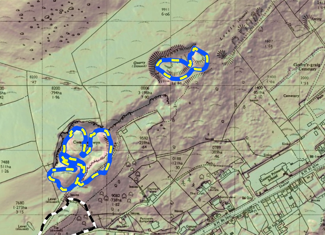
By December 2021, the Cilmaengwyn site appeared within the Welsh Government’s non-coal dataset.
It was recorded as:
A quarry-based feature (sandstone)
With a defined reference (L44A)
And a measured area of approximately 1,847 m²
This aligns with the revised boundary submitted earlier that year.
Governance Statements
At a Governance and Audit Committee meeting in November 2021, the council reaffirmed its approach.
It confirmed that:
“…further specialist advice [had been] commissioned… to deal with the risk represented by the tip.”
The same report emphasised the importance of transparency:
“Meetings where decisions are made… are accurately recorded in the interests of openness and transparency.”
By this stage, the revised boundary had been known internally for several months.
It is not referenced within the report.
A Consistent Absence
Across this period — from March 2021 through to early 2022 — a consistent pattern can be observed.
The revised boundary was:
Submitted to the national programme
Recorded within official datasets
And materially reduced the apparent extent of the tip
Yet it was not:
Presented at key meetings
Referenced in internal correspondence
Reflected in commissioned technical work
Included in reports placed before decision-makers
This is not a single omission.
It is a repeated absence across multiple stages of the decision-making process.
The Key Question
Given that the revised boundary had been formally submitted to the national programme:
why does it not appear to have been incorporated into the council’s subsequent decision-making?
Closing
Taken together, the record from this period shows that the revised boundary was not simply overlooked at a single point in time.
It was absent across correspondence, committee discussions, commissioned work and formal reporting over many months.
By the end of 2021, the smaller, quarry-based boundary had been formally recorded within the national programme and was known within official systems.
Yet decisions continued to be taken on the basis of a materially different understanding of the site.
The extent to which that revised information was considered — and how it informed subsequent decisions — is not evident from the available documentation.